Bridge Statistics for Boynton Beach, Florida (FL)
Condition, Traffic, Stress, Structural Evaluation, Project Costs
- New bridges - historical statistics
- 61950-1959
- 41960-1969
- 121970-1979
- 71980-1989
- 231990-1999
- 42000-2009
- 12010-2019
- 12020-2022
- Reconstructed bridges - Historical Statistics
- 11970-1979
- 11980-1989
- 21990-1999
- 02000-2009
- 22010-2019
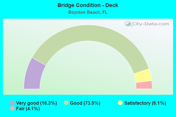
- Bridge Condition - Deck
- 16.3%Very good
- 73.5%Good
- 6.1%Satisfactory
- 4.1%Fair
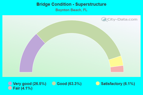
- Bridge Condition - Superstructure
- 26.5%Very good
- 63.3%Good
- 6.1%Satisfactory
- 4.1%Fair
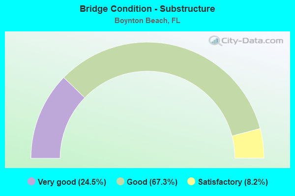
- Bridge Condition - Substructure
- 24.5%Very good
- 67.3%Good
- 8.2%Satisfactory
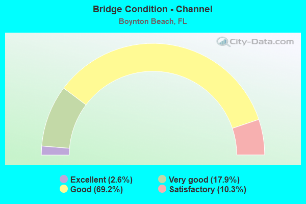
- Bridge Condition - Channel
- 2.6%Excellent
- 17.9%Very good
- 69.2%Good
- 10.3%Satisfactory
Find on map >> Show street view
Structure Number: 70087, Location: 8.4 MI E/O SR-29 (Lat: 26.768333, Lng: -81.304167), Route carried "on" structure: State highway 80, Year Built: 2018, Status: Open, Structure Length: 2.56m (8.40ft), Average Daily Traffic: 5,550 (year 2020), Truck Traffic: 12%, Average Future Daily Traffic: 9,629 (year 2042), Design Load: HL 93, Features Intersected: GOODNO DRAINAGE CANAL
Minimum Vertical Clearance: 30+ m (98+ ft), Kilometerpoint: 28.561, Lanes on structure: 2, Base Highway Network: Yes, Owner: State Highway Agency, Approaching Roadway Width: 12.8m (42.0ft), Material/Design: Concrete continuous, Design/Construction: Slab, Number Of Spans In Main Unit: 3, Length of Maximum Span: 8.5m (27.9ft), Curb or Sidewalk Widths: Left: 0.0m, Right: 1.5m (4.9ft), Curb-To-Curb Width: 12.8m (42.0ft), Out-to-Out Width: 15.5m (50.9ft)
Condition: Deck: Good, Superstructure: Good, Substructure: Good, Channel: Excellent, Operating Rating: 54.5 metric tons, Method Used To Determine Operating Rating: Load and Resistance Factor (LRFR), Inventory Rating: 42.1 metric tons, Method Used To Determine Inventory Rating: Load and Resistance Factor (LRFR), Structural Evaluation: Better than present minimum criteria, Deck Geometry: Equal to present desirable criteria, Waterway Adequacy: Superior to present desirable criteria, Approach Roadway Alignment: Equal to present desirable criteria, Designated Inspection Frequency: Every 24 months, Underwater Inspection Frequency: Every 24 months, Inspection Date: August 2020, Underwater Inspection Date: July 2020, Deck Structure Type: Concrete Cast-file-Place
Find on map >> Show street view
Structure Number: 70091, Location: 2.9 MI W/O CR-833 (Lat: 26.752683, Lng: -81.129869), Route carried "on" structure: State highway 80, Year Built: 2020, Status: Open, Structure Length: 2.07m (6.79ft), Average Daily Traffic: 5,550 (year 2020), Truck Traffic: 12%, Average Future Daily Traffic: 9,629 (year 2042), Design Load: HL 93, Features Intersected: HENDRY-HILLIARD CANAL
Minimum Vertical Clearance: 30+ m (98+ ft), Kilometerpoint: 46.368, Lanes on structure: 4, Base Highway Network: Yes, Owner: State Highway Agency, Approaching Roadway Width: 21.0m (68.9ft), Material/Design: Concrete continuous, Design/Construction: Slab, Number Of Spans In Main Unit: 2, Length of Maximum Span: 10.4m (34.1ft), Curb-To-Curb Width: 21.0m (68.9ft), Out-to-Out Width: 21.9m (71.9ft)
Condition: Deck: Very good, Superstructure: Very good, Substructure: Very good, Channel: Good, Operating Rating: 46.1 metric tons, Method Used To Determine Operating Rating: Load and Resistance Factor (LRFR), Inventory Rating: 35.6 metric tons, Method Used To Determine Inventory Rating: Load and Resistance Factor (LRFR), Structural Evaluation: Equal to present desirable criteria, Deck Geometry: Superior to present desirable criteria, Waterway Adequacy: Equal to present desirable criteria, Approach Roadway Alignment: Equal to present desirable criteria, Designated Inspection Frequency: Every 24 months, Underwater Inspection Frequency: Every 23 months, Inspection Date: March 2020, Underwater Inspection Date: March 2020, Deck Structure Type: Concrete Cast-file-Place, Wearing Surface/Protective System: Wearing Surface: Monolithic Concrete
Find on map >> Show street view
Structure Number: 930001, Location: 0.7 Mi N of Boynton Bch (Lat: 26.539150, Lng: -80.057467), Route carried "on" structure: US 1, Year Built: 1963, Year Reconstructed: 1997, Status: Open, Structure Length: 4.79m (15.72ft), Average Daily Traffic: 18,200 (year 2020), Truck Traffic: 9%, Average Future Daily Traffic: 31,577 (year 2042), Design Load: HS 20+Mod, Features Intersected: Boynton Canal C16
Minimum Vertical Clearance: 30+ m (98+ ft), Kilometerpoint: 24.264, Lanes on structure: 5, Owner: State Highway Agency, Approaching Roadway Width: 25.6m (84.0ft), Skew: 20 degrees, Material/Design: Concrete, Design/Construction: Slab, Number Of Spans In Main Unit: 5, Length of Maximum Span: 9.6m (31.5ft), Curb or Sidewalk Widths: Left: 2.3m (7.5ft), Right: 2.3m (7.5ft), Curb-To-Curb Width: 25.6m (84.0ft), Out-to-Out Width: 31.1m (102.0ft)
Condition: Deck: Good, Superstructure: Good, Substructure: Good, Channel: Satisfactory, Inventory Rating: 83.7 metric tons, Method Used To Determine Inventory Rating: Load Factor (LF), Structural Evaluation: Better than present minimum criteria, Deck Geometry: Superior to present desirable criteria, Waterway Adequacy: Superior to present desirable criteria, Approach Roadway Alignment: Equal to present desirable criteria, Designated Inspection Frequency: Every 24 months, Underwater Inspection Frequency: Every 24 months, Inspection Date: November 2020, Underwater Inspection Date: November 2020, Deck Structure Type: Concrete Cast-file-Place
Find on map >> Show street view
Structure Number: 930214, Location: 0.25MI E OF US 1 (Lat: 26.514500, Lng: -80.055669), Route carried "on" structure: County highway 792, Year Built: 1967, Status: Open, Structure Length: 13.90m (45.60ft), Average Daily Traffic: 9,625 (year 2021), Truck Traffic: 11%, Average Future Daily Traffic: 13,200 (year 2042), Design Load: HS 20, Features Intersected: INTRACOASTAL WATERWAY, Facility Carried by Structure: WOOLBRIGHT ROAD
Minimum Vertical Clearance: 30+ m (98+ ft), Kilometerpoint: 0.266, Lanes on structure: 2, Owner: County Highway Agency, Approaching Roadway Width: 8.5m (27.9ft), Navigation Control: Yes ( Vertical Clearance: 6.1m (20.0ft), Horizontal Clearance: 27.4m (89.9ft)), Material/Design: Steel, Design/Construction: Movable - Bascule, Number Of Spans In Main Unit: 1, Number Of Approach Spans: 6, Length of Maximum Span: 44.4m (145.7ft), Curb or Sidewalk Widths: Left: 1.2m (3.9ft), Right: 1.2m (3.9ft), Curb-To-Curb Width: 8.6m (28.2ft), Out-to-Out Width: 11.6m (38.1ft)
Condition: Deck: Good, Superstructure: Good, Substructure: Good, Channel: Good, Operating Rating: 36.7 metric tons, Method Used To Determine Operating Rating: Load Factor (LF), Inventory Rating: 22.0 metric tons, Method Used To Determine Inventory Rating: Load Factor (LF), Structural Evaluation: Somewhat better than minimum adequacy, Deck Geometry: Meets minimum limits, Waterway Adequacy: Better than present minimum criteria, Approach Roadway Alignment: Equal to present desirable criteria, Designated Inspection Frequency: Every 24 months, Critical Feature Inspection Frequency: Every 24 months, Underwater Inspection Frequency: Every 24 months, Other Special Inspection Frequency: Every 12 months, Inspection Date: May 2021, Critical Feature Inspection Date: May 2021, Underwater Inspection Date: May 2021, Other Special Inspection Date: May 2021, Deck Structure Type: Open Grating
Find on map >> Show street view
Structure Number: 930237, Location: 0.7 mi. W of I-95 (Lat: 26.527867, Lng: -80.084544), Route carried "on" structure: State highway 804, Year Built: 1960, Year Reconstructed: 1977, Status: Open, Structure Length: 2.29m (7.51ft), Average Daily Traffic: 30,500 (year 2020), Truck Traffic: 4%, Average Future Daily Traffic: 52,918 (year 2042), Design Load: HS 20, Features Intersected: Lake Ida / Canal E-4, Facility Carried by Structure: Boynton Bch Blvd
Minimum Vertical Clearance: 30+ m (98+ ft), Kilometerpoint: 12.056, Lanes on structure: 6, Base Highway Network: Yes, Owner: State Highway Agency, Approaching Roadway Width: 28.8m (94.5ft), Skew: 20 degrees, Material/Design: Prestressed concrete, Design/Construction: Slab, Number Of Spans In Main Unit: 3, Length of Maximum Span: 7.6m (24.9ft), Curb or Sidewalk Widths: Left: 1.6m (5.2ft), Right: 1.6m (5.2ft), Curb-To-Curb Width: 28.8m (94.5ft), Out-to-Out Width: 32.7m (107.3ft)
Condition: Deck: Good, Superstructure: Good, Substructure: Good, Channel: Satisfactory, Operating Rating: 56.1 metric tons, Method Used To Determine Operating Rating: Load Factor (LF), Inventory Rating: 33.7 metric tons, Method Used To Determine Inventory Rating: Load Factor (LF), Structural Evaluation: Better than present minimum criteria, Deck Geometry: Superior to present desirable criteria, Waterway Adequacy: Superior to present desirable criteria, Approach Roadway Alignment: Equal to present desirable criteria, Designated Inspection Frequency: Every 24 months, Underwater Inspection Frequency: Every 24 months, Inspection Date: March 2020, Underwater Inspection Date: March 2020, Deck Structure Type: Concrete Precast Panels, Wearing Surface/Protective System: Wearing Surface: Bituminous
Find on map >> Show street view
Structure Number: 930285, Location: 1 mile West of US 1 (Lat: 26.528911, Lng: -80.073094), Route carried "on" structure: State highway 804, Year Built: 1976, Status: Open, Structure Length: 8.40m (27.56ft), Average Daily Traffic: 55,500 (year 2020), Truck Traffic: 3%, Average Future Daily Traffic: 96,292 (year 2042), Design Load: HS 20+Mod, Features Intersected: I 95 SR 9
Minimum Vertical Clearance: 30+ m (98+ ft), Kilometerpoint: 13.177, Lanes on structure: 6, Lanes under structure: 10, Owner: State Highway Agency, Approaching Roadway Width: 21.3m (69.9ft), Material/Design: Prestressed concrete, Design/Construction: Stringer/Multi-beam, Number Of Spans In Main Unit: 4, Length of Maximum Span: 30.5m (100.1ft), Curb or Sidewalk Widths: Left: 1.8m (5.9ft), Right: 1.8m (5.9ft), Curb-To-Curb Width: 24.8m (81.4ft), Out-to-Out Width: 29.2m (95.8ft)
Condition: Deck: Very good, Superstructure: Satisfactory, Substructure: Good, Operating Rating: 45.1 metric tons, Method Used To Determine Operating Rating: Load and Resistance Factor (LRFR), Inventory Rating: 29.0 metric tons, Method Used To Determine Inventory Rating: Load and Resistance Factor (LRFR), Structural Evaluation: Equal to present minimum criteria, Deck Geometry: Somewhat better than minimum adequacy, Underclear: Somewhat better than minimum adequacy, Approach Roadway Alignment: Equal to present desirable criteria, Designated Inspection Frequency: Every 24 months, Inspection Date: September 2020, Deck Structure Type: Concrete Cast-file-Place, Wearing Surface/Protective System: Wearing Surface: Bituminous
Find on map >> Show street view
Structure Number: 930287, Location: 0.7 mile North of SR 804 (Lat: 26.539236, Lng: -80.072875), Route carried "on" structure: Interstate 95, Year Built: 1975, Year Reconstructed: 2002, Status: Open, Structure Length: 7.59m (24.90ft), Average Daily Traffic: 92,500 (year 2021), Truck Traffic: 9%, Average Future Daily Traffic: 160,488 (year 2042), Design Load: HS 20+Mod, Features Intersected: Boynton Canal C-16
Minimum Vertical Clearance: 30+ m (98+ ft), Kilometerpoint: 24.847, Lanes on structure: 12, Base Highway Network: Yes, Owner: State Highway Agency, Approaching Roadway Width: 53.2m (174.5ft), Skew: 31 degrees, Material/Design: Prestressed concrete, Design/Construction: Stringer/Multi-beam, Number Of Spans In Main Unit: 6, Length of Maximum Span: 13.6m (44.6ft), Curb-To-Curb Width: 60.5m (198.5ft), Out-to-Out Width: 62.5m (205.1ft)
Condition: Deck: Good, Superstructure: Good, Substructure: Good, Channel: Good, Operating Rating: 51.5 metric tons, Method Used To Determine Operating Rating: Load Factor (LF), Inventory Rating: 31.2 metric tons, Method Used To Determine Inventory Rating: Load Factor (LF), Structural Evaluation: Better than present minimum criteria, Deck Geometry: Superior to present desirable criteria, Waterway Adequacy: Superior to present desirable criteria, Approach Roadway Alignment: Equal to present desirable criteria, Designated Inspection Frequency: Every 24 months, Underwater Inspection Frequency: Every 24 months, Inspection Date: April 2021, Underwater Inspection Date: April 2021, Deck Structure Type: Concrete Cast-file-Place
Find on map >> Show street view
Structure Number: 930289, Location: Just West of I 95 (Lat: 26.528919, Lng: -80.074436), Route carried "on" structure: State highway 804, Year Built: 1976, Status: Open, Structure Length: 7.06m (23.16ft), Average Daily Traffic: 55,500 (year 2020), Truck Traffic: 3%, Average Future Daily Traffic: 96,292 (year 2042), Design Load: HS 20+Mod, Features Intersected: CSX RR
Minimum Vertical Clearance: 30+ m (98+ ft), Kilometerpoint: 13.057, Lanes on structure: 7, Base Highway Network: Yes, Owner: State Highway Agency, Approaching Roadway Width: 21.3m (69.9ft), Skew: 20 degrees, Material/Design: Prestressed concrete, Design/Construction: Stringer/Multi-beam, Number Of Spans In Main Unit: 3, Length of Maximum Span: 30.5m (100.1ft), Curb or Sidewalk Widths: Left: 1.9m (6.2ft), Right: 1.9m (6.2ft), Curb-To-Curb Width: 28.2m (92.5ft), Out-to-Out Width: 32.6m (107.0ft)
Condition: Deck: Good, Superstructure: Good, Substructure: Very good, Operating Rating: 54.5 metric tons, Method Used To Determine Operating Rating: Load and Resistance Factor (LRFR), Inventory Rating: 31.7 metric tons, Method Used To Determine Inventory Rating: Load and Resistance Factor (LRFR), Structural Evaluation: Better than present minimum criteria, Deck Geometry: Somewhat better than minimum adequacy, Underclear: Better than present minimum criteria, Approach Roadway Alignment: Equal to present desirable criteria, Designated Inspection Frequency: Every 24 months, Inspection Date: September 2020, Deck Structure Type: Concrete Cast-file-Place, Wearing Surface/Protective System: Wearing Surface: Bituminous
Find on map >> Show street view
Structure Number: 9303, Location: W of I 95 on Woolbright (Lat: 26.514497, Lng: -80.074086), Route carried "on" structure: City street , Year Built: 1975, Year Reconstructed: 2018, Status: Open, Structure Length: 4.34m (14.24ft), Average Daily Traffic: 44,000 (year 2020), Truck Traffic: 5%, Average Future Daily Traffic: 76,340 (year 2042), Design Load: HS 20, Features Intersected: C.S.X. R/R, Facility Carried by Structure: Woolbright Road
Minimum Vertical Clearance: 30+ m (98+ ft), Kilometerpoint: 1.609, Lanes on structure: 8, Owner: State Highway Agency, Approaching Roadway Width: 41.1m (134.8ft), Skew: 21 degrees, Material/Design: Prestressed concrete, Design/Construction: Stringer/Multi-beam, Number Of Spans In Main Unit: 3, Length of Maximum Span: 15.3m (50.2ft), Curb or Sidewalk Widths: Left: 1.8m (5.9ft), Right: 1.8m (5.9ft), Curb-To-Curb Width: 41.1m (134.8ft), Out-to-Out Width: 42.9m (140.7ft)
Condition: Deck: Good, Superstructure: Very good, Substructure: Very good, Operating Rating: 44.1 metric tons, Method Used To Determine Operating Rating: Load and Resistance Factor (LRFR), Inventory Rating: 33.9 metric tons, Method Used To Determine Inventory Rating: Load and Resistance Factor (LRFR), Structural Evaluation: Equal to present desirable criteria, Deck Geometry: Superior to present desirable criteria, Underclear: Better than present minimum criteria, Approach Roadway Alignment: Equal to present desirable criteria, Designated Inspection Frequency: Every 24 months, Inspection Date: December 2020, Deck Structure Type: Concrete Cast-file-Place
Find on map >> Show street view
Structure Number: 930301, Location: I 95 Exit 56 (Lat: 26.514517, Lng: -80.072203), Route carried "on" structure: City street , Year Built: 1975, Status: Open, Structure Length: 8.28m (27.17ft), Average Daily Traffic: 44,000 (year 2020), Truck Traffic: 5%, Average Future Daily Traffic: 76,340 (year 2042), Design Load: HS 20, Features Intersected: I 95 SR 9, Facility Carried by Structure: Woolbright Road
Minimum Vertical Clearance: 30+ m (98+ ft), Kilometerpoint: 1.777, Lanes on structure: 7, Lanes under structure: 10, Owner: State Highway Agency, Approaching Roadway Width: 32.3m (106.0ft), Skew: 20 degrees, Material/Design: Prestressed concrete, Design/Construction: Stringer/Multi-beam, Number Of Spans In Main Unit: 4, Length of Maximum Span: 30.4m (99.7ft), Curb or Sidewalk Widths: Left: 1.8m (5.9ft), Right: 1.9m (6.2ft), Curb-To-Curb Width: 32.3m (106.0ft), Out-to-Out Width: 39.3m (128.9ft)
Condition: Deck: Good, Superstructure: Good, Substructure: Good, Operating Rating: 41.2 metric tons, Method Used To Determine Operating Rating: Load and Resistance Factor (LRFR), Inventory Rating: 28.4 metric tons, Method Used To Determine Inventory Rating: Load and Resistance Factor (LRFR), Structural Evaluation: Better than present minimum criteria, Deck Geometry: Superior to present desirable criteria, Underclear: Equal to present minimum criteria, Approach Roadway Alignment: Equal to present desirable criteria, Designated Inspection Frequency: Every 24 months, Inspection Date: December 2020, Deck Structure Type: Concrete Cast-file-Place
Find on map >> Show street view
Structure Number: 930302, Location: 0.25 MI. W OF I-95 (Lat: 26.507497, Lng: -80.078725), Route carried "on" structure: County highway , Year Built: 1975, Status: Open, Structure Length: 4.23m (13.88ft), Average Daily Traffic: 13,000 (year 2020), Truck Traffic: 2%, Average Future Daily Traffic: 22,555 (year 2042), Design Load: HS 20, Features Intersected: LWDD E-4 CANAL, Facility Carried by Structure: SW 23RD AVE.
Minimum Vertical Clearance: 30+ m (98+ ft), Kilometerpoint: 4.406, Lanes on structure: 3, Owner: County Highway Agency, Approaching Roadway Width: 13.5m (44.3ft), Skew: 1 degrees, Material/Design: Prestressed concrete, Design/Construction: Stringer/Multi-beam, Number Of Spans In Main Unit: 3, Length of Maximum Span: 14.0m (45.9ft), Curb or Sidewalk Widths: Left: 1.5m (4.9ft), Right: 1.5m (4.9ft), Curb-To-Curb Width: 13.5m (44.3ft), Out-to-Out Width: 17.2m (56.4ft)
Condition: Deck: Good, Superstructure: Good, Substructure: Satisfactory, Channel: Good, Operating Rating: 65.3 metric tons, Method Used To Determine Operating Rating: Load Factor (LF), Inventory Rating: 39.0 metric tons, Method Used To Determine Inventory Rating: Load Factor (LF), Structural Evaluation: Equal to present minimum criteria, Deck Geometry: Somewhat better than minimum adequacy, Waterway Adequacy: Equal to present desirable criteria, Approach Roadway Alignment: Equal to present desirable criteria, Designated Inspection Frequency: Every 24 months, Underwater Inspection Frequency: Every 24 months, Inspection Date: April 2020, Underwater Inspection Date: April 2020, Deck Structure Type: Concrete Cast-file-Place
Find on map >> Show street view
Structure Number: 930303, Location: Just West of I 95 (Lat: 26.507683, Lng: -80.076544), Route carried "on" structure: City street , Year Built: 1975, Status: Open, Structure Length: 4.32m (14.17ft), Average Daily Traffic: 14,800 (year 2020), Truck Traffic: 7%, Average Future Daily Traffic: 25,678 (year 2042), Design Load: HS 20, Features Intersected: CSX Railroad, Facility Carried by Structure: SW 23 Ave Golf Rd
Minimum Vertical Clearance: 30+ m (98+ ft), Kilometerpoint: 4.624, Lanes on structure: 2, Owner: State Highway Agency, Approaching Roadway Width: 13.4m (44.0ft), Skew: 1 degrees, Material/Design: Prestressed concrete, Design/Construction: Stringer/Multi-beam, Number Of Spans In Main Unit: 3, Length of Maximum Span: 15.1m (49.5ft), Curb or Sidewalk Widths: Left: 1.5m (4.9ft), Right: 1.5m (4.9ft), Curb-To-Curb Width: 13.4m (44.0ft), Out-to-Out Width: 17.2m (56.4ft)
Condition: Deck: Good, Superstructure: Very good, Substructure: Very good, Operating Rating: 50.2 metric tons, Method Used To Determine Operating Rating: Load Factor (LF), Inventory Rating: 30.0 metric tons, Method Used To Determine Inventory Rating: Load Factor (LF), Structural Evaluation: Better than present minimum criteria, Deck Geometry: Equal to present minimum criteria, Underclear: Somewhat better than minimum adequacy, Approach Roadway Alignment: Equal to present desirable criteria, Designated Inspection Frequency: Every 24 months, Inspection Date: March 2020, Deck Structure Type: Concrete Cast-file-Place
Find on map >> Show street view
Structure Number: 930304, Location: Over I 95 1 mi S of SR804 (Lat: 26.507700, Lng: -80.074750), Route carried "on" structure: City street , Year Built: 1975, Status: Open, Structure Length: 9.87m (32.38ft), Average Daily Traffic: 14,800 (year 2020), Truck Traffic: 7%, Average Future Daily Traffic: 25,678 (year 2042), Design Load: HS 20, Features Intersected: I 95 SR 9, Facility Carried by Structure: SW 23 Ave Golf Rd
Minimum Vertical Clearance: 30+ m (98+ ft), Kilometerpoint: 4.770, Lanes on structure: 2, Lanes under structure: 12, Owner: State Highway Agency, Approaching Roadway Width: 13.4m (44.0ft), Skew: 3 degrees, Material/Design: Prestressed concrete, Design/Construction: Stringer/Multi-beam, Number Of Spans In Main Unit: 4, Length of Maximum Span: 36.3m (119.1ft), Curb or Sidewalk Widths: Left: 1.5m (4.9ft), Right: 1.5m (4.9ft), Curb-To-Curb Width: 13.4m (44.0ft), Out-to-Out Width: 17.2m (56.4ft)
Condition: Deck: Good, Superstructure: Good, Substructure: Good, Operating Rating: 60.9 metric tons, Method Used To Determine Operating Rating: Load Factor (LF), Inventory Rating: 36.5 metric tons, Method Used To Determine Inventory Rating: Load Factor (LF), Structural Evaluation: Better than present minimum criteria, Deck Geometry: Equal to present minimum criteria, Underclear: High priority of corrective action, Approach Roadway Alignment: Equal to present desirable criteria, Designated Inspection Frequency: Every 24 months, Inspection Date: March 2020, Deck Structure Type: Concrete Cast-file-Place
Find on map >> Show street view
Structure Number: 93037, Location: 1 Mile S of Boynton Inlet (Lat: 26.527044, Lng: -80.053975), Route carried "on" structure: State highway 804, Year Built: 2001, Status: Open, Structure Length: 10.82m (35.50ft), Average Daily Traffic: 6,100 (year 2021), Truck Traffic: 5%, Average Future Daily Traffic: 10,584 (year 2042), Design Load: HS 20+Mod, Features Intersected: Intracoastal Waterway
Minimum Vertical Clearance: 30+ m (98+ ft), Kilometerpoint: 15.278, Lanes on structure: 2, Owner: State Highway Agency, Approaching Roadway Width: 11.7m (38.4ft), Navigation Control: Yes ( Vertical Clearance: 6.4m (21.0ft), Horizontal Clearance: 38.1m (125.0ft)), Material/Design: Steel, Design/Construction: Movable - Bascule, Number Of Spans In Main Unit: 1, Number Of Approach Spans: 3, Length of Maximum Span: 45.9m (150.6ft), Curb or Sidewalk Widths: Left: 1.8m (5.9ft), Right: 1.8m (5.9ft), Curb-To-Curb Width: 11.7m (38.4ft), Out-to-Out Width: 16.7m (54.8ft)
Condition: Deck: Very good, Superstructure: Good, Substructure: Very good, Channel: Good, Operating Rating: 65.1 metric tons, Method Used To Determine Operating Rating: Load Factor (LF), Inventory Rating: 39.0 metric tons, Method Used To Determine Inventory Rating: Load Factor (LF), Structural Evaluation: Better than present minimum criteria, Deck Geometry: Somewhat better than minimum adequacy, Waterway Adequacy: Superior to present desirable criteria, Approach Roadway Alignment: Equal to present minimum criteria, Designated Inspection Frequency: Every 24 months, Critical Feature Inspection Frequency: Every 24 months, Underwater Inspection Frequency: Every 24 months, Other Special Inspection Frequency: Every 12 months, Inspection Date: April 2021, Critical Feature Inspection Date: April 2021, Underwater Inspection Date: April 2021, Other Special Inspection Date: April 2021, Deck Structure Type: Concrete Cast-file-Place
Find on map >> Show street view
Structure Number: 930428, Location: 6.2 MILES SOUTH OF SR-802 (Lat: 26.528053, Lng: -80.172589), Route carried "on" structure: State highway 91, Year Built: 1992, Status: Open, Structure Length: 7.03m (23.06ft), Average Daily Traffic: 83,000 (year 2021), Truck Traffic: 13%, Average Future Daily Traffic: 144,005 (year 2042), Design Load: HS 20+Mod, Features Intersected: SR 804 BOYNTON BCH BLVD
Minimum Vertical Clearance: 30+ m (98+ ft), Kilometerpoint: 22.127, Lanes on structure: 9, Lanes under structure: 7, Base Highway Network: Yes, Owner: State Toll Authority, Approaching Roadway Width: 51.8m (169.9ft), Skew: 30 degrees, Material/Design: Prestressed concrete, Design/Construction: Stringer/Multi-beam, Number Of Spans In Main Unit: 4, Length of Maximum Span: 25.3m (83.0ft), Curb-To-Curb Width: 49.8m (163.4ft), Out-to-Out Width: 52.0m (170.6ft)
Condition: Deck: Good, Superstructure: Good, Substructure: Good, Operating Rating: 37.4 metric tons, Method Used To Determine Operating Rating: Load and Resistance Factor (LRFR), Inventory Rating: 20.0 metric tons, Method Used To Determine Inventory Rating: Load and Resistance Factor (LRFR), Structural Evaluation: Somewhat better than minimum adequacy, Deck Geometry: Superior to present desirable criteria, Underclear: Equal to present minimum criteria, Approach Roadway Alignment: Equal to present desirable criteria, Designated Inspection Frequency: Every 24 months, Inspection Date: October 2021, Deck Structure Type: Concrete Cast-file-Place
Find on map >> Show street view
Structure Number: 930429, Location: 6.2 MILES SOUTH OF SR-802 (Lat: 26.524450, Lng: -80.172150), Route carried "on" structure: Ramp State highway 91, Year Built: 1992, Status: Open, Structure Length: 7.16m (23.49ft), Average Daily Traffic: 8,500 (year 2021), Truck Traffic: 13%, Average Future Daily Traffic: 14,748 (year 2042), Design Load: HS 20+Mod, Features Intersected: CANAL E-2-E(BOYN BC INT)
Minimum Vertical Clearance: 30+ m (98+ ft), Kilometerpoint: 0.019, Lanes on structure: 1, Toll: On toll road, Owner: State Toll Authority, Approaching Roadway Width: 8.2m (26.9ft), Skew: 4 degrees, Material/Design: Prestressed concrete, Design/Construction: Stringer/Multi-beam, Number Of Spans In Main Unit: 3, Length of Maximum Span: 31.4m (103.0ft), Curb-To-Curb Width: 8.2m (26.9ft), Out-to-Out Width: 9.1m (29.9ft)
Condition: Deck: Good, Superstructure: Very good, Substructure: Good, Channel: Very good, Operating Rating: 44.1 metric tons, Method Used To Determine Operating Rating: Load and Resistance Factor (LRFR), Inventory Rating: 31.7 metric tons, Method Used To Determine Inventory Rating: Load and Resistance Factor (LRFR), Structural Evaluation: Better than present minimum criteria, Deck Geometry: Superior to present desirable criteria, Waterway Adequacy: Equal to present desirable criteria, Approach Roadway Alignment: Equal to present minimum criteria, Designated Inspection Frequency: Every 24 months, Underwater Inspection Frequency: Every 24 months, Inspection Date: October 2021, Underwater Inspection Date: October 2021, Deck Structure Type: Concrete Cast-file-Place
Find on map >> Show street view
Structure Number: 93043, Location: 6.2 MILES SOUTH OF SR-802 (Lat: 26.526461, Lng: -80.172158), Route carried "on" structure: Ramp State highway 91, Year Built: 1992, Status: Open, Structure Length: 4.05m (13.29ft), Average Daily Traffic: 2,200 (year 2021), Truck Traffic: 13%, Average Future Daily Traffic: 3,817 (year 2042), Design Load: HS 20, Features Intersected: CANAL E-2-E(BOYN BC INT)
Minimum Vertical Clearance: 30+ m (98+ ft), Kilometerpoint: 0.307, Lanes on structure: 1, Toll: On toll road, Owner: State Toll Authority, Approaching Roadway Width: 8.5m (27.9ft), Skew: 3 degrees, Material/Design: Prestressed concrete, Design/Construction: Stringer/Multi-beam, Number Of Spans In Main Unit: 3, Length of Maximum Span: 16.2m (53.1ft), Curb-To-Curb Width: 8.5m (27.9ft), Out-to-Out Width: 9.3m (30.5ft)
Condition: Deck: Good, Superstructure: Very good, Substructure: Good, Channel: Very good, Operating Rating: 48.7 metric tons, Method Used To Determine Operating Rating: Load Factor (LF), Inventory Rating: 33.3 metric tons, Method Used To Determine Inventory Rating: Load Factor (LF), Structural Evaluation: Better than present minimum criteria, Deck Geometry: Superior to present desirable criteria, Waterway Adequacy: Equal to present desirable criteria, Approach Roadway Alignment: Equal to present minimum criteria, Designated Inspection Frequency: Every 24 months, Underwater Inspection Frequency: Every 24 months, Inspection Date: October 2021, Underwater Inspection Date: October 2021, Deck Structure Type: Concrete Cast-file-Place
Find on map >> Show street view
Structure Number: 930431, Location: 6.2 MILES SOUTH OF SR-802 (Lat: 26.526522, Lng: -80.172975), Route carried "on" structure: Ramp State highway 91, Year Built: 1992, Status: Open, Structure Length: 4.51m (14.80ft), Average Daily Traffic: 2,200 (year 2021), Truck Traffic: 13%, Average Future Daily Traffic: 3,817 (year 2042), Design Load: HS 20+Mod, Features Intersected: CANAL E-2-W(BOYN BC INT)
Minimum Vertical Clearance: 30+ m (98+ ft), Kilometerpoint: 0.000, Lanes on structure: 1, Toll: On toll road, Owner: State Toll Authority, Approaching Roadway Width: 8.2m (26.9ft), Skew: 4 degrees, Material/Design: Prestressed concrete, Design/Construction: Stringer/Multi-beam, Number Of Spans In Main Unit: 3, Length of Maximum Span: 21.3m (69.9ft), Curb-To-Curb Width: 8.2m (26.9ft), Out-to-Out Width: 9.1m (29.9ft)
Condition: Deck: Good, Superstructure: Very good, Substructure: Good, Channel: Very good, Operating Rating: 50.0 metric tons, Method Used To Determine Operating Rating: Load and Resistance Factor (LRFR), Inventory Rating: 37.9 metric tons, Method Used To Determine Inventory Rating: Load and Resistance Factor (LRFR), Structural Evaluation: Better than present minimum criteria, Deck Geometry: Superior to present desirable criteria, Waterway Adequacy: Equal to present desirable criteria, Approach Roadway Alignment: Equal to present minimum criteria, Designated Inspection Frequency: Every 24 months, Underwater Inspection Frequency: Every 24 months, Inspection Date: October 2021, Underwater Inspection Date: October 2021, Deck Structure Type: Concrete Cast-file-Place
Find on map >> Show street view
Structure Number: 930432, Location: 6.2 MILES SOUTH OF SR-802 (Lat: 26.531053, Lng: -80.173036), Route carried "on" structure: Ramp State highway 91, Year Built: 1992, Status: Open, Structure Length: 4.15m (13.62ft), Average Daily Traffic: 8,500 (year 2021), Truck Traffic: 13%, Average Future Daily Traffic: 14,748 (year 2042), Design Load: HS 20+Mod, Features Intersected: CANAL E-2-W(BOYN BC INT)
Minimum Vertical Clearance: 30+ m (98+ ft), Kilometerpoint: 0.502, Lanes on structure: 1, Toll: On toll road, Owner: State Toll Authority, Approaching Roadway Width: 8.5m (27.9ft), Skew: 3 degrees, Material/Design: Prestressed concrete, Design/Construction: Stringer/Multi-beam, Number Of Spans In Main Unit: 3, Length of Maximum Span: 23.2m (76.1ft), Curb-To-Curb Width: 8.5m (27.9ft), Out-to-Out Width: 9.3m (30.5ft)
Condition: Deck: Good, Superstructure: Very good, Substructure: Good, Channel: Good, Operating Rating: 37.2 metric tons, Method Used To Determine Operating Rating: Load and Resistance Factor (LRFR), Inventory Rating: 33.3 metric tons, Method Used To Determine Inventory Rating: Load and Resistance Factor (LRFR), Structural Evaluation: Better than present minimum criteria, Deck Geometry: Superior to present desirable criteria, Waterway Adequacy: Equal to present desirable criteria, Approach Roadway Alignment: Equal to present minimum criteria, Designated Inspection Frequency: Every 24 months, Underwater Inspection Frequency: Every 24 months, Inspection Date: October 2021, Underwater Inspection Date: October 2021, Deck Structure Type: Concrete Cast-file-Place
Find on map >> Show street view
Structure Number: 930433, Location: 1.5 mile North of SR 804 (Lat: 26.550656, Lng: -80.070764), Route carried "on" structure: City street , Year Built: 1992, Status: Open, Structure Length: 3.88m (12.73ft), Average Daily Traffic: 47,500 (year 2021), Truck Traffic: 4%, Average Future Daily Traffic: 82,412 (year 2042), Design Load: HS 20+Mod, Features Intersected: CSX RR, Facility Carried by Structure: E Gateway Blvd
Minimum Vertical Clearance: 30+ m (98+ ft), Kilometerpoint: 2.100, Lanes on structure: 8, Owner: State Highway Agency, Approaching Roadway Width: 23.7m (77.8ft), Skew: 20 degrees, Material/Design: Prestressed concrete, Design/Construction: Stringer/Multi-beam, Number Of Spans In Main Unit: 1, Length of Maximum Span: 38.8m (127.3ft), Curb or Sidewalk Widths: Left: 1.5m (4.9ft), Right: 2.4m (7.9ft), Curb-To-Curb Width: 41.5m (136.2ft), Out-to-Out Width: 46.4m (152.2ft)
Condition: Deck: Good, Superstructure: Good, Substructure: Good, Inventory Rating: 72.2 metric tons, Method Used To Determine Inventory Rating: Load Factor (LF), Structural Evaluation: Better than present minimum criteria, Deck Geometry: Superior to present desirable criteria, Underclear: Better than present minimum criteria, Approach Roadway Alignment: Equal to present desirable criteria, Designated Inspection Frequency: Every 24 months, Inspection Date: March 2021, Deck Structure Type: Concrete Cast-file-Place
Find on map >> Show street view
Structure Number: 930434, Location: 1.5 miles North of SR 804 (Lat: 26.550583, Lng: -80.070111), Route carried "on" structure: City street , Year Built: 1992, Status: Open, Structure Length: 6.52m (21.39ft), Average Daily Traffic: 47,500 (year 2021), Truck Traffic: 4%, Average Future Daily Traffic: 82,412 (year 2042), Design Load: HS 20+Mod, Features Intersected: I 95 SR 9, Facility Carried by Structure: E Gateway Blvd
Minimum Vertical Clearance: 7.22m (23.69ft), Kilometerpoint: 2.161, Lanes on structure: 8, Lanes under structure: 10, Owner: State Highway Agency, Approaching Roadway Width: 19.5m (64.0ft), Skew: 20 degrees, Material/Design: Prestressed concrete, Design/Construction: Stringer/Multi-beam, Number Of Spans In Main Unit: 2, Length of Maximum Span: 33.2m (108.9ft), Curb or Sidewalk Widths: Left: 1.5m (4.9ft), Right: 2.4m (7.9ft), Curb-To-Curb Width: 34.1m (111.9ft), Out-to-Out Width: 39.0m (128.0ft)
Condition: Deck: Good, Superstructure: Good, Substructure: Good, Inventory Rating: 61.0 metric tons, Method Used To Determine Inventory Rating: Load Factor (LF), Structural Evaluation: Better than present minimum criteria, Deck Geometry: Equal to present minimum criteria, Underclear: Equal to present minimum criteria, Approach Roadway Alignment: Equal to present desirable criteria, Designated Inspection Frequency: Every 24 months, Inspection Date: March 2021, Deck Structure Type: Concrete Cast-file-Place
Find on map >> Show street view
Structure Number: 930435, Location: 700 ft S of Gateway Blvd (Lat: 26.549444, Lng: -80.070000), Route carried "on" structure: Ramp Interstate 95, Year Built: 1992, Status: Open, Structure Length: 22.34m (73.29ft), Average Daily Traffic: 14,500 (year 2021), Truck Traffic: 5%, Average Future Daily Traffic: 25,158 (year 2042), Design Load: HS 20+Mod, Features Intersected: None
Minimum Vertical Clearance: 30+ m (98+ ft), Kilometerpoint: 0.304, Lanes on structure: 3, Owner: State Highway Agency, Approaching Roadway Width: 10.9m (35.8ft), Material/Design: Prestressed concrete, Design/Construction: Stringer/Multi-beam, Number Of Spans In Main Unit: 8, Length of Maximum Span: 28.4m (93.2ft), Curb-To-Curb Width: 14.6m (47.9ft), Out-to-Out Width: 15.6m (51.2ft)
Condition: Deck: Good, Superstructure: Good, Substructure: Good, Inventory Rating: 64.8 metric tons, Method Used To Determine Inventory Rating: Load Factor (LF), Structural Evaluation: Better than present minimum criteria, Deck Geometry: Better than present minimum criteria, Approach Roadway Alignment: Equal to present desirable criteria, Designated Inspection Frequency: Every 24 months, Inspection Date: March 2021, Deck Structure Type: Concrete Cast-file-Place
Find on map >> Show street view
Structure Number: 930438, Location: 0.5 MILES WEST OF SR-809 (Lat: 26.528083, Lng: -80.130972), Route carried "on" structure: State highway 804, Year Built: 1992, Status: Open, Structure Length: 2.17m (7.12ft), Average Daily Traffic: 46,500 (year 2020), Truck Traffic: 5%, Average Future Daily Traffic: 80,678 (year 2042), Design Load: HS 20, Features Intersected: LWDD E-3 CANAL, Facility Carried by Structure: Boynton Bch Blvd.
Minimum Vertical Clearance: 30+ m (98+ ft), Kilometerpoint: 7.409, Lanes on structure: 6, Base Highway Network: Yes, Owner: State Highway Agency, Approaching Roadway Width: 30.0m (98.4ft), Skew: 20 degrees, Material/Design: Concrete continuous, Design/Construction: Slab, Number Of Spans In Main Unit: 3, Length of Maximum Span: 10.7m (35.1ft), Curb or Sidewalk Widths: Left: 2.3m (7.5ft), Right: 2.3m (7.5ft), Curb-To-Curb Width: 30.0m (98.4ft), Out-to-Out Width: 35.5m (116.5ft)
Condition: Deck: Good, Superstructure: Good, Substructure: Good, Channel: Good, Operating Rating: 46.0 metric tons, Method Used To Determine Operating Rating: Load Factor (LF), Inventory Rating: 27.2 metric tons, Method Used To Determine Inventory Rating: Load Factor (LF), Structural Evaluation: Equal to present minimum criteria, Deck Geometry: Superior to present desirable criteria, Waterway Adequacy: Superior to present desirable criteria, Approach Roadway Alignment: Equal to present desirable criteria, Designated Inspection Frequency: Every 24 months, Underwater Inspection Frequency: Every 24 months, Inspection Date: September 2020, Underwater Inspection Date: September 2020, Deck Structure Type: Concrete Cast-file-Place
Find on map >> Show street view
Structure Number: 930448, Location: BOYNTON BCH WEST OF TPK (Lat: 26.528056, Lng: -80.173039), Route carried "on" structure: State highway 804, Year Built: 1992, Status: Open, Structure Length: 0.80m (2.62ft), Average Daily Traffic: 36,500 (year 2018), Truck Traffic: 4%, Average Future Daily Traffic: 63,328 (year 2040), Features Intersected: E-2-W canal, Facility Carried by Structure: Boynton Bch Blvd
Minimum Vertical Clearance: 30+ m (98+ ft), Kilometerpoint: 3.124, Lanes on structure: 7, Owner: State Highway Agency, Approaching Roadway Width: 23.0m (75.5ft), Skew: 10 degrees, Material/Design: Aluminum, Iron, Design/Construction: Culvert, Number Of Spans In Main Unit: 1, Length of Maximum Span: 8.0m (26.2ft), Curb or Sidewalk Widths: Left: 2.4m (7.9ft), Right: 2.4m (7.9ft)
Condition: Channel: Satisfactory, Culverts: Satisfactory, Operating Rating: 54.3 metric tons, Method Used To Determine Operating Rating: Load Testing, Inventory Rating: 32.7 metric tons, Method Used To Determine Inventory Rating: Load Testing, Structural Evaluation: Equal to present minimum criteria, Waterway Adequacy: Superior to present desirable criteria, Approach Roadway Alignment: Equal to present desirable criteria, Designated Inspection Frequency: Every 24 months, Underwater Inspection Frequency: Every 24 months, Inspection Date: May 2020, Underwater Inspection Date: May 2020
Find on map >> Show street view
Structure Number: 930449, Location: BOYNTON BCH EAST OF TPK (Lat: 26.528069, Lng: -80.172156), Route carried "on" structure: State highway 804, Year Built: 1992, Status: Open, Structure Length: 0.80m (2.62ft), Average Daily Traffic: 47,500 (year 2018), Truck Traffic: 5%, Average Future Daily Traffic: 82,413 (year 2040), Features Intersected: E-2-W canal, Facility Carried by Structure: Boynton Bch Blvd
Minimum Vertical Clearance: 30+ m (98+ ft), Kilometerpoint: 3.299, Lanes on structure: 7, Owner: State Highway Agency, Approaching Roadway Width: 23.0m (75.5ft), Skew: 10 degrees, Material/Design: Aluminum, Iron, Design/Construction: Culvert, Number Of Spans In Main Unit: 1, Length of Maximum Span: 8.0m (26.2ft), Curb or Sidewalk Widths: Left: 2.4m (7.9ft), Right: 2.4m (7.9ft)
Condition: Channel: Satisfactory, Culverts: Satisfactory, Operating Rating: 54.3 metric tons, Method Used To Determine Operating Rating: Load Testing, Inventory Rating: 32.7 metric tons, Method Used To Determine Inventory Rating: Load Testing, Structural Evaluation: Equal to present minimum criteria, Waterway Adequacy: Superior to present desirable criteria, Approach Roadway Alignment: Equal to present desirable criteria, Designated Inspection Frequency: Every 24 months, Underwater Inspection Frequency: Every 24 months, Inspection Date: May 2020, Underwater Inspection Date: May 2020
Find on map >> Show street view
Structure Number: 93101, Location: 0.7 MI NORTH OF SR-804 (Lat: 26.538933, Lng: -80.172722), Route carried "on" structure: State highway 91, Year Built: 2006, Status: Open, Structure Length: 2.65m (8.69ft), Average Daily Traffic: 71,600 (year 2021), Truck Traffic: 16%, Average Future Daily Traffic: 124,226 (year 2042), Design Load: HS 20, Features Intersected: BOYNTON CANAL
Minimum Vertical Clearance: 30+ m (98+ ft), Kilometerpoint: 23.350, Lanes on structure: 6, Base Highway Network: Yes, Toll: On toll road, Owner: State Toll Authority, Approaching Roadway Width: 43.9m (144.0ft), Skew: 10 degrees, Material/Design: Prestressed concrete, Design/Construction: Stringer/Multi-beam, Number Of Spans In Main Unit: 1, Length of Maximum Span: 26.5m (86.9ft), Curb-To-Curb Width: 43.9m (144.0ft), Out-to-Out Width: 45.4m (149.0ft)
Condition: Deck: Good, Superstructure: Very good, Substructure: Very good, Channel: Very good, Operating Rating: 80.1 metric tons, Method Used To Determine Operating Rating: Load Factor (LF), Inventory Rating: 50.0 metric tons, Method Used To Determine Inventory Rating: Load Factor (LF), Structural Evaluation: Equal to present desirable criteria, Deck Geometry: Superior to present desirable criteria, Waterway Adequacy: Equal to present minimum criteria, Approach Roadway Alignment: Equal to present desirable criteria, Designated Inspection Frequency: Every 24 months, Inspection Date: October 2021, Deck Structure Type: Concrete Cast-file-Place
Find on map >> Show street view
Structure Number: 934344, Location: 0.5MI. W OF I-95 (Lat: 26.572272, Lng: -80.080294), Route carried "on" structure: County highway , Year Built: 1989, Status: Open, Structure Length: 3.21m (10.53ft), Average Daily Traffic: 41,500 (year 2020), Truck Traffic: 5%, Average Future Daily Traffic: 72,002 (year 2042), Design Load: H 20, Features Intersected: LAKEWOOD E4 CANAL, Facility Carried by Structure: HYPOLUXO RD.
Minimum Vertical Clearance: 30+ m (98+ ft), Kilometerpoint: 3.286, Lanes on structure: 6, Owner: County Highway Agency, Approaching Roadway Width: 21.9m (71.9ft), Skew: 21 degrees, Material/Design: Prestressed concrete, Design/Construction: Slab, Number Of Spans In Main Unit: 3, Length of Maximum Span: 10.7m (35.1ft), Curb or Sidewalk Widths: Left: 2.6m (8.5ft), Right: 1.7m (5.6ft), Curb-To-Curb Width: 31.1m (102.0ft), Out-to-Out Width: 32.4m (106.3ft)
Condition: Deck: Fair, Superstructure: Fair, Substructure: Good, Channel: Good, Operating Rating: 45.4 metric tons, Method Used To Determine Operating Rating: Load Factor (LF), Inventory Rating: 38.1 metric tons, Method Used To Determine Inventory Rating: Load Factor (LF), Structural Evaluation: Somewhat better than minimum adequacy, Deck Geometry: Superior to present desirable criteria, Waterway Adequacy: Equal to present desirable criteria, Approach Roadway Alignment: Equal to present desirable criteria, Designated Inspection Frequency: Every 24 months, Underwater Inspection Frequency: Every 24 months, Inspection Date: April 2020, Underwater Inspection Date: April 2020, Deck Structure Type: Concrete Precast Panels, Wearing Surface/Protective System: Wearing Surface: Bituminous
Find on map >> Show street view
Structure Number: 934363, Location: 0.5MI W of SR-809 Mil Trl (Lat: 26.549508, Lng: -80.130878), Route carried "on" structure: County highway , Year Built: 2002, Status: Open, Structure Length: 2.13m (6.99ft), Average Daily Traffic: 15,700 (year 2021), Truck Traffic: 4%, Average Future Daily Traffic: 18,840 (year 2042), Design Load: HS 20+Mod, Features Intersected: LWDD E-3 Canal, Facility Carried by Structure: Gateway Blvd.
Minimum Vertical Clearance: 30+ m (98+ ft), Kilometerpoint: 1.920, Lanes on structure: 4, Owner: County Highway Agency, Approaching Roadway Width: 18.6m (61.0ft), Skew: 20 degrees, Material/Design: Prestressed concrete, Design/Construction: Slab, Number Of Spans In Main Unit: 3, Length of Maximum Span: 10.7m (35.1ft), Curb or Sidewalk Widths: Left: 2.0m (6.6ft), Right: 2.0m (6.6ft), Curb-To-Curb Width: 18.6m (61.0ft), Out-to-Out Width: 29.7m (97.4ft)
Condition: Deck: Good, Superstructure: Good, Substructure: Good, Channel: Good, Operating Rating: 85.0 metric tons, Method Used To Determine Operating Rating: Load Factor (LF), Inventory Rating: 51.1 metric tons, Method Used To Determine Inventory Rating: Load Factor (LF), Structural Evaluation: Better than present minimum criteria, Deck Geometry: Equal to present minimum criteria, Waterway Adequacy: Equal to present desirable criteria, Approach Roadway Alignment: Equal to present desirable criteria, Designated Inspection Frequency: Every 24 months, Underwater Inspection Frequency: Every 24 months, Inspection Date: August 2021, Underwater Inspection Date: August 2021, Deck Structure Type: Concrete Precast Panels, Wearing Surface/Protective System: Wearing Surface: Bituminous
Find on map >> Show street view
Structure Number: 934461, Location: 0.2MI W OF I-95 (Lat: 26.514306, Lng: -80.078533), Route carried "on" structure: County highway , Year Built: 1971, Status: Open, Structure Length: 1.84m (6.04ft), Average Daily Traffic: 44,000 (year 2020), Truck Traffic: 6%, Average Future Daily Traffic: 76,340 (year 2042), Design Load: HS 20, Features Intersected: LWDD E-4 CANAL, Facility Carried by Structure: SW 15TH AVE
Minimum Vertical Clearance: 30+ m (98+ ft), Kilometerpoint: 1.178, Lanes on structure: 6, Owner: County Highway Agency, Approaching Roadway Width: 22.2m (72.8ft), Skew: 20 degrees, Material/Design: Prestressed concrete, Design/Construction: Slab, Number Of Spans In Main Unit: 3, Length of Maximum Span: 6.3m (20.7ft), Curb or Sidewalk Widths: Left: 1.1m (3.6ft), Right: 1.1m (3.6ft), Curb-To-Curb Width: 22.2m (72.8ft), Out-to-Out Width: 26.5m (86.9ft)
Condition: Deck: Good, Superstructure: Good, Substructure: Good, Channel: Good, Operating Rating: 84.3 metric tons, Method Used To Determine Operating Rating: Load Factor (LF), Inventory Rating: 50.3 metric tons, Method Used To Determine Inventory Rating: Load Factor (LF), Structural Evaluation: Better than present minimum criteria, Deck Geometry: Meets minimum limits, Waterway Adequacy: Better than present minimum criteria, Approach Roadway Alignment: Better than present minimum criteria, Designated Inspection Frequency: Every 24 months, Underwater Inspection Frequency: Every 24 months, Inspection Date: April 2020, Underwater Inspection Date: April 2020, Deck Structure Type: Concrete Precast Panels, Wearing Surface/Protective System: Wearing Surface: Bituminous
Find on map >> Show street view
Structure Number: 934468, Location: 0.7MI W OF CONGRESS AVE. (Lat: 26.513261, Lng: -80.102317), Route carried "on" structure: County highway , Year Built: 1991, Status: Open, Structure Length: 1.77m (5.81ft), Average Daily Traffic: 25,000 (year 2020), Truck Traffic: 2%, Average Future Daily Traffic: 43,375 (year 2042), Design Load: HS 20, Features Intersected: QUAIL COVEY ROAD, Facility Carried by Structure: Woolbright Road EB
Minimum Vertical Clearance: 30+ m (98+ ft), Kilometerpoint: 3.705, Lanes on structure: 2, Lanes under structure: 2, Owner: County Highway Agency, Approaching Roadway Width: 9.0m (29.5ft), Material/Design: Prestressed concrete, Design/Construction: Stringer/Multi-beam, Number Of Spans In Main Unit: 1, Length of Maximum Span: 17.7m (58.1ft), Curb or Sidewalk Widths: Left: 0.0m, Right: 2.0m (6.6ft), Curb-To-Curb Width: 10.2m (33.5ft), Out-to-Out Width: 13.1m (43.0ft)
Condition: Deck: Very good, Superstructure: Very good, Substructure: Very good, Operating Rating: 51.7 metric tons, Method Used To Determine Operating Rating: Load Factor (LF), Inventory Rating: 46.3 metric tons, Method Used To Determine Inventory Rating: Load Factor (LF), Structural Evaluation: Equal to present desirable criteria, Deck Geometry: Somewhat better than minimum adequacy, Underclear: Equal to present minimum criteria, Approach Roadway Alignment: Equal to present desirable criteria, Designated Inspection Frequency: Every 24 months, Inspection Date: July 2020, Deck Structure Type: Concrete Cast-file-Place
Find on map >> Show street view
Structure Number: 934469, Location: 0.7MI W OF CONGRESS AVE (Lat: 26.513397, Lng: -80.102328), Route carried "on" structure: County highway , Year Built: 1991, Status: Open, Structure Length: 1.77m (5.81ft), Average Daily Traffic: 25,000 (year 2020), Truck Traffic: 2%, Average Future Daily Traffic: 43,375 (year 2042), Design Load: HS 20, Features Intersected: QUAIL COVEY ROAD, Facility Carried by Structure: Woolbright Road WB
Minimum Vertical Clearance: 30+ m (98+ ft), Kilometerpoint: 3.705, Lanes on structure: 2, Lanes under structure: 2, Owner: County Highway Agency, Approaching Roadway Width: 8.9m (29.2ft), Material/Design: Prestressed concrete, Design/Construction: Stringer/Multi-beam, Number Of Spans In Main Unit: 1, Length of Maximum Span: 17.7m (58.1ft), Curb or Sidewalk Widths: Left: 2.0m (6.6ft), Right: 0.0m, Curb-To-Curb Width: 10.1m (33.1ft), Out-to-Out Width: 13.1m (43.0ft)
Condition: Deck: Very good, Superstructure: Very good, Substructure: Very good, Operating Rating: 51.7 metric tons, Method Used To Determine Operating Rating: Load Factor (LF), Inventory Rating: 46.3 metric tons, Method Used To Determine Inventory Rating: Load Factor (LF), Structural Evaluation: Equal to present desirable criteria, Deck Geometry: Somewhat better than minimum adequacy, Underclear: Meets minimum limits, Approach Roadway Alignment: Equal to present desirable criteria, Designated Inspection Frequency: Every 24 months, Inspection Date: July 2020, Deck Structure Type: Concrete Cast-file-Place
Find on map >> Show street view
Structure Number: 934487, Location: 0.8Mi W OF MILITARY TRAIL (Lat: 26.552867, Lng: -80.130903), Route carried "on" structure: County highway , Year Built: 1981, Status: Open, Structure Length: 1.95m (6.40ft), Average Daily Traffic: 9,000 (year 2020), Truck Traffic: 2%, Average Future Daily Traffic: 15,615 (year 2042), Design Load: HS 20, Features Intersected: LWDD E-3 CANAL, Facility Carried by Structure: LE CHALET BLVD
Minimum Vertical Clearance: 30+ m (98+ ft), Kilometerpoint: 2.000, Lanes on structure: 4, Owner: County Highway Agency, Approaching Roadway Width: 13.1m (43.0ft), Skew: 21 degrees, Material/Design: Prestressed concrete, Design/Construction: Slab, Number Of Spans In Main Unit: 3, Length of Maximum Span: 6.5m (21.3ft), Curb or Sidewalk Widths: Left: 1.2m (3.9ft), Right: 1.2m (3.9ft), Curb-To-Curb Width: 13.5m (44.3ft), Out-to-Out Width: 17.7m (58.1ft)
Condition: Deck: Fair, Superstructure: Fair, Substructure: Good, Channel: Good, Inventory Rating: 59.9 metric tons, Method Used To Determine Inventory Rating: Allowable Stress (AS), Structural Evaluation: Somewhat better than minimum adequacy, Deck Geometry: High priority of replacement, Waterway Adequacy: Equal to present desirable criteria, Approach Roadway Alignment: Equal to present desirable criteria, Designated Inspection Frequency: Every 24 months, Underwater Inspection Frequency: Every 24 months, Inspection Date: June 2020, Underwater Inspection Date: June 2020, Deck Structure Type: Concrete Precast Panels, Wearing Surface/Protective System: Wearing Surface: Bituminous
Find on map >> Show street view
Structure Number: 934491, Location: 0.8Mi NORTH OF CR-804 (Lat: 26.539333, Lng: -80.090706), Route carried "on" structure: County highway 807, Year Built: 1982, Status: Open, Structure Length: 3.84m (12.60ft), Average Daily Traffic: 36,500 (year 2020), Truck Traffic: 2%, Average Future Daily Traffic: 63,327 (year 2042), Design Load: HS 20, Features Intersected: BOYNTON CANAL C-16, Facility Carried by Structure: CONGRESS AVE
Minimum Vertical Clearance: 30+ m (98+ ft), Kilometerpoint: 1.276, Lanes on structure: 6, Base Highway Network: Yes, Owner: County Highway Agency, Approaching Roadway Width: 24.0m (78.7ft), Skew: 20 degrees, Material/Design: Prestressed concrete, Design/Construction: Slab, Number Of Spans In Main Unit: 3, Length of Maximum Span: 12.8m (42.0ft), Curb or Sidewalk Widths: Left: 1.5m (4.9ft), Right: 2.5m (8.2ft), Curb-To-Curb Width: 24.5m (80.4ft), Out-to-Out Width: 35.6m (116.8ft)
Condition: Deck: Good, Superstructure: Good, Substructure: Good, Channel: Good, Operating Rating: 62.0 metric tons, Method Used To Determine Operating Rating: Load Factor (LF), Inventory Rating: 37.2 metric tons, Method Used To Determine Inventory Rating: Load Factor (LF), Structural Evaluation: Better than present minimum criteria, Deck Geometry: Somewhat better than minimum adequacy, Waterway Adequacy: Better than present minimum criteria, Approach Roadway Alignment: Equal to present desirable criteria, Designated Inspection Frequency: Every 24 months, Underwater Inspection Frequency: Every 24 months, Inspection Date: June 2020, Underwater Inspection Date: June 2020, Deck Structure Type: Concrete Precast Panels, Wearing Surface/Protective System: Wearing Surface: Bituminous
Find on map >> Show street view
Structure Number: 934499, Location: 0.6Mi NORTH OF SR-804 (Lat: 26.539222, Lng: -80.064453), Route carried "on" structure: County highway , Year Built: 1959, Year Reconstructed: 1987, Status: Open, Structure Length: 4.56m (14.96ft), Average Daily Traffic: 10,900 (year 2020), Truck Traffic: 2%, Average Future Daily Traffic: 18,912 (year 2042), Design Load: H 20, Features Intersected: LWDD C-16 CANAL, Facility Carried by Structure: SEACREST BLVD.
Minimum Vertical Clearance: 30+ m (98+ ft), Kilometerpoint: 0.061, Lanes on structure: 4, Owner: County Highway Agency, Approaching Roadway Width: 18.2m (59.7ft), Material/Design: Prestressed concrete, Design/Construction: Slab, Number Of Spans In Main Unit: 5, Length of Maximum Span: 9.1m (29.9ft), Curb or Sidewalk Widths: Left: 2.2m (7.2ft), Right: 1.3m (4.3ft), Curb-To-Curb Width: 20.2m (66.3ft), Out-to-Out Width: 25.1m (82.3ft)
Condition: Deck: Good, Superstructure: Good, Substructure: Good, Channel: Good, Operating Rating: 50.7 metric tons, Method Used To Determine Operating Rating: Allowable Stress (AS), Inventory Rating: 45.5 metric tons, Method Used To Determine Inventory Rating: Allowable Stress (AS), Structural Evaluation: Better than present minimum criteria, Deck Geometry: Better than present minimum criteria, Waterway Adequacy: Better than present minimum criteria, Approach Roadway Alignment: Equal to present desirable criteria, Designated Inspection Frequency: Every 24 months, Underwater Inspection Frequency: Every 24 months, Inspection Date: June 2020, Underwater Inspection Date: June 2020, Deck Structure Type: Concrete Precast Panels, Wearing Surface/Protective System: Wearing Surface: Bituminous
Find on map >> Show street view
Structure Number: 934913, Location: 0.7MI N OF BOYNTON BH BL (Lat: 26.539131, Lng: -80.147331), Route carried "on" structure: County highway , Year Built: 1991, Status: Open, Structure Length: 2.74m (8.99ft), Average Daily Traffic: 15,500 (year 2020), Truck Traffic: 3%, Average Future Daily Traffic: 26,893 (year 2042), Design Load: HS 20, Features Intersected: BOYNTON CANAL, Facility Carried by Structure: JOG ROAD (SB)
Minimum Vertical Clearance: 30+ m (98+ ft), Kilometerpoint: 1.181, Lanes on structure: 3, Owner: County Highway Agency, Approaching Roadway Width: 11.7m (38.4ft), Material/Design: Prestressed concrete, Design/Construction: Stringer/Multi-beam, Number Of Spans In Main Unit: 1, Length of Maximum Span: 27.4m (89.9ft), Curb or Sidewalk Widths: Left: 1.9m (6.2ft), Right: 0.0m, Curb-To-Curb Width: 14.0m (45.9ft), Out-to-Out Width: 18.5m (60.7ft)
Condition: Deck: Very good, Superstructure: Very good, Substructure: Very good, Channel: Good, Operating Rating: 37.2 metric tons, Method Used To Determine Operating Rating: Load Factor (LF), Inventory Rating: 22.3 metric tons, Method Used To Determine Inventory Rating: Load Factor (LF), Structural Evaluation: Somewhat better than minimum adequacy, Deck Geometry: Somewhat better than minimum adequacy, Waterway Adequacy: Equal to present desirable criteria, Approach Roadway Alignment: Equal to present desirable criteria, Designated Inspection Frequency: Every 24 months, Inspection Date: Febuary 2020, Deck Structure Type: Concrete Cast-file-Place
Find on map >> Show street view
Structure Number: 934914, Location: 0.8Mi N OF BOYNTON BCH B (Lat: 26.538856, Lng: -80.106564), Route carried "on" structure: County highway , Year Built: 1980, Year Reconstructed: 2010, Status: Open, Structure Length: 0.95m (3.12ft), Average Daily Traffic: 14,600 (year 2020), Truck Traffic: 2%, Average Future Daily Traffic: 25,331 (year 2042), Design Load: HL 93, Features Intersected: BOYNTON CANAL C-16, Facility Carried by Structure: LAWRENCE ROAD
Minimum Vertical Clearance: 30+ m (98+ ft), Kilometerpoint: 2.831, Lanes on structure: 4, Owner: County Highway Agency, Approaching Roadway Width: 16.0m (52.5ft), Material/Design: Prestressed concrete, Design/Construction: Slab, Number Of Spans In Main Unit: 1, Length of Maximum Span: 9.5m (31.2ft), Curb or Sidewalk Widths: Left: 1.8m (5.9ft), Right: 1.8m (5.9ft), Curb-To-Curb Width: 16.1m (52.8ft), Out-to-Out Width: 20.4m (66.9ft)
Condition: Deck: Good, Superstructure: Good, Substructure: Good, Channel: Good, Operating Rating: 40.8 metric tons, Method Used To Determine Operating Rating: Load and Resistance Factor (LRFR), Inventory Rating: 36.9 metric tons, Method Used To Determine Inventory Rating: Load and Resistance Factor (LRFR), Structural Evaluation: Better than present minimum criteria, Deck Geometry: Meets minimum limits, Waterway Adequacy: Equal to present desirable criteria, Approach Roadway Alignment: Equal to present desirable criteria, Designated Inspection Frequency: Every 24 months, Underwater Inspection Frequency: Every 24 months, Inspection Date: June 2020, Underwater Inspection Date: June 2020, Deck Structure Type: Concrete Precast Panels, Wearing Surface/Protective System: Wearing Surface: Bituminous
Find on map >> Show street view
Structure Number: 934934, Location: 0.7Mi N OF SR-804 (Lat: 26.538928, Lng: -80.122900), Route carried "on" structure: County highway , Year Built: 1991, Status: Open, Structure Length: 3.84m (12.60ft), Average Daily Traffic: 34,000 (year 2020), Truck Traffic: 4%, Average Future Daily Traffic: 58,990 (year 2042), Design Load: HS 20, Features Intersected: C. Stanley Weaver Canal, Facility Carried by Structure: MILITARY TR. SB
Minimum Vertical Clearance: 30+ m (98+ ft), Kilometerpoint: 23.677, Lanes on structure: 3, Owner: County Highway Agency, Approaching Roadway Width: 12.6m (41.3ft), Material/Design: Concrete continuous, Design/Construction: Slab, Number Of Spans In Main Unit: 3, Length of Maximum Span: 12.9m (42.3ft), Curb or Sidewalk Widths: Left: 1.5m (4.9ft), Right: 0.0m, Curb-To-Curb Width: 12.6m (41.3ft), Out-to-Out Width: 15.2m (49.9ft)
Condition: Deck: Good, Superstructure: Good, Substructure: Good, Channel: Very good, Operating Rating: 67.1 metric tons, Method Used To Determine Operating Rating: Load Factor (LF), Inventory Rating: 39.9 metric tons, Method Used To Determine Inventory Rating: Load Factor (LF), Structural Evaluation: Better than present minimum criteria, Deck Geometry: Meets minimum limits, Waterway Adequacy: Better than present minimum criteria, Approach Roadway Alignment: Equal to present desirable criteria, Designated Inspection Frequency: Every 24 months, Underwater Inspection Frequency: Every 24 months, Inspection Date: April 2020, Underwater Inspection Date: April 2020, Deck Structure Type: Concrete Cast-file-Place
Find on map >> Show street view
Structure Number: 934935, Location: 0.7Mi N OF SR-804 (Lat: 26.538928, Lng: -80.122714), Route carried "on" structure: County highway , Year Built: 1991, Status: Open, Structure Length: 3.84m (12.60ft), Average Daily Traffic: 10,000 (year 2020), Truck Traffic: 10%, Average Future Daily Traffic: 12,000 (year 2042), Design Load: HS 20, Features Intersected: C. Stanley Weaver Canal, Facility Carried by Structure: MILITARY TR. NB
Minimum Vertical Clearance: 30+ m (98+ ft), Kilometerpoint: 23.677, Lanes on structure: 3, Base Highway Network: Yes, Owner: County Highway Agency, Approaching Roadway Width: 13.4m (44.0ft), Material/Design: Concrete continuous, Design/Construction: Slab, Number Of Spans In Main Unit: 3, Length of Maximum Span: 13.1m (43.0ft), Curb or Sidewalk Widths: Left: 0.0m, Right: 2.6m (8.5ft), Curb-To-Curb Width: 13.4m (44.0ft), Out-to-Out Width: 17.4m (57.1ft)
Condition: Deck: Good, Superstructure: Good, Substructure: Good, Channel: Good, Operating Rating: 68.9 metric tons, Method Used To Determine Operating Rating: Load Factor (LF), Inventory Rating: 41.7 metric tons, Method Used To Determine Inventory Rating: Load Factor (LF), Structural Evaluation: Better than present minimum criteria, Deck Geometry: Somewhat better than minimum adequacy, Waterway Adequacy: Better than present minimum criteria, Approach Roadway Alignment: Equal to present desirable criteria, Designated Inspection Frequency: Every 24 months, Underwater Inspection Frequency: Every 24 months, Inspection Date: April 2020, Underwater Inspection Date: April 2020, Deck Structure Type: Concrete Cast-file-Place
Find on map >> Show street view
Structure Number: 934942, Location: 0.3MI E of CONGRESS AVE. (Lat: 26.557228, Lng: -80.085050), Route carried "on" structure: County highway , Year Built: 1990, Status: Open, Structure Length: 3.30m (10.83ft), Average Daily Traffic: 6,000 (year 2020), Truck Traffic: 7%, Average Future Daily Traffic: 10,410 (year 2042), Design Load: HS 20, Features Intersected: E-4 CANAL, Facility Carried by Structure: MINER RD.
Minimum Vertical Clearance: 30+ m (98+ ft), Kilometerpoint: 2.066, Lanes on structure: 2, Owner: County Highway Agency, Approaching Roadway Width: 9.7m (31.8ft), Material/Design: Prestressed concrete, Design/Construction: Slab, Number Of Spans In Main Unit: 3, Length of Maximum Span: 11.1m (36.4ft), Curb or Sidewalk Widths: Left: 0.0m, Right: 2.6m (8.5ft), Curb-To-Curb Width: 12.5m (41.0ft), Out-to-Out Width: 16.0m (52.5ft)
Condition: Deck: Good, Superstructure: Good, Substructure: Good, Channel: Good, Operating Rating: 42.6 metric tons, Method Used To Determine Operating Rating: Allowable Stress (AS), Inventory Rating: 25.4 metric tons, Method Used To Determine Inventory Rating: Allowable Stress (AS), Structural Evaluation: Equal to present minimum criteria, Deck Geometry: Somewhat better than minimum adequacy, Waterway Adequacy: Superior to present desirable criteria, Approach Roadway Alignment: Equal to present desirable criteria, Designated Inspection Frequency: Every 24 months, Underwater Inspection Frequency: Every 24 months, Inspection Date: August 2020, Underwater Inspection Date: August 2020, Deck Structure Type: Concrete Precast Panels
Find on map >> Show street view
Structure Number: 934948, Location: 0.5Mi WEST OF CR-809 (Lat: 26.487856, Lng: -80.130850), Route carried "on" structure: City street , Year Built: 1997, Status: Open, Structure Length: 2.29m (7.51ft), Average Daily Traffic: 6,400 (year 2020), Truck Traffic: 2%, Average Future Daily Traffic: 11,104 (year 2042), Design Load: HS 25 or greater, Features Intersected: E-3 CANAL, Facility Carried by Structure: FLAVOR PICT ROAD
Minimum Vertical Clearance: 30+ m (98+ ft), Kilometerpoint: 3.449, Lanes on structure: 2, Owner: County Highway Agency, Approaching Roadway Width: 12.0m (39.4ft), Material/Design: Prestressed concrete, Design/Construction: Slab, Number Of Spans In Main Unit: 3, Length of Maximum Span: 10.7m (35.1ft), Curb or Sidewalk Widths: Left: 2.0m (6.6ft), Right: 0.0m, Curb-To-Curb Width: 13.6m (44.6ft), Out-to-Out Width: 17.0m (55.8ft)
Condition: Deck: Good, Superstructure: Good, Substructure: Very good, Channel: Very good, Operating Rating: 70.3 metric tons, Method Used To Determine Operating Rating: Load Factor (LF), Inventory Rating: 42.2 metric tons, Method Used To Determine Inventory Rating: Load Factor (LF), Structural Evaluation: Better than present minimum criteria, Deck Geometry: Superior to present desirable criteria, Waterway Adequacy: Equal to present desirable criteria, Approach Roadway Alignment: Better than present minimum criteria, Designated Inspection Frequency: Every 24 months, Underwater Inspection Frequency: Every 24 months, Inspection Date: June 2020, Underwater Inspection Date: June 2020, Deck Structure Type: Concrete Precast Panels, Wearing Surface/Protective System: Wearing Surface: Bituminous
Find on map >> Show street view
Structure Number: 934951, Location: 0.7MI N OF BOYNTON BEACH (Lat: 26.539103, Lng: -80.147142), Route carried "on" structure: County highway , Year Built: 1996, Status: Open, Structure Length: 2.87m (9.42ft), Average Daily Traffic: 15,500 (year 2020), Truck Traffic: 3%, Average Future Daily Traffic: 26,893 (year 2042), Design Load: HS 20+Mod, Features Intersected: BOYNTON CANAL, Facility Carried by Structure: JOG ROAD (NB)
Minimum Vertical Clearance: 30+ m (98+ ft), Kilometerpoint: 1.181, Lanes on structure: 3, Owner: County Highway Agency, Approaching Roadway Width: 12.3m (40.4ft), Skew: 1 degrees, Material/Design: Prestressed concrete, Design/Construction: Stringer/Multi-beam, Number Of Spans In Main Unit: 1, Length of Maximum Span: 28.7m (94.2ft), Curb or Sidewalk Widths: Left: 0.0m, Right: 1.8m (5.9ft), Curb-To-Curb Width: 13.1m (43.0ft), Out-to-Out Width: 16.2m (53.1ft)
Condition: Deck: Very good, Superstructure: Very good, Substructure: Very good, Channel: Good, Operating Rating: 89.2 metric tons, Method Used To Determine Operating Rating: Load Factor (LF), Inventory Rating: 53.5 metric tons, Method Used To Determine Inventory Rating: Load Factor (LF), Structural Evaluation: Equal to present desirable criteria, Deck Geometry: Meets minimum limits, Waterway Adequacy: Equal to present desirable criteria, Approach Roadway Alignment: Equal to present desirable criteria, Designated Inspection Frequency: Every 24 months, Inspection Date: Febuary 2020, Deck Structure Type: Concrete Cast-file-Place