Bridge Statistics for Boynton Beach, Florida (FL)
Condition, Traffic, Stress, Structural Evaluation, Project Costs
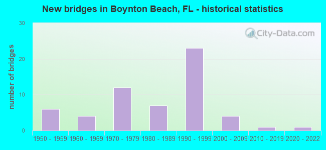
- New bridges - historical statistics
- 61950-1959
- 41960-1969
- 121970-1979
- 71980-1989
- 231990-1999
- 42000-2009
- 12010-2019
- 12020-2022
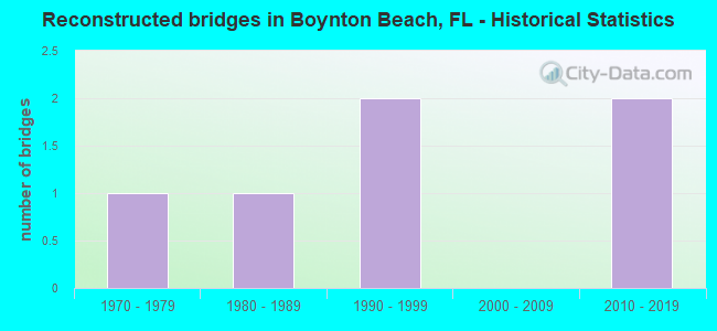
- Reconstructed bridges - Historical Statistics
- 11970-1979
- 11980-1989
- 21990-1999
- 02000-2009
- 22010-2019
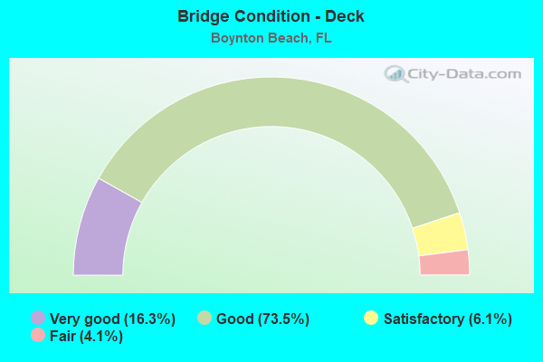
- Bridge Condition - Deck
- 16.3%Very good
- 73.5%Good
- 6.1%Satisfactory
- 4.1%Fair
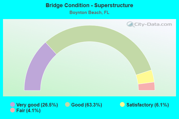
- Bridge Condition - Superstructure
- 26.5%Very good
- 63.3%Good
- 6.1%Satisfactory
- 4.1%Fair
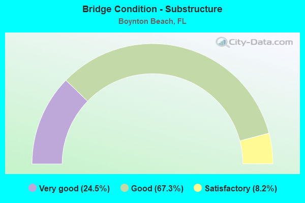
- Bridge Condition - Substructure
- 24.5%Very good
- 67.3%Good
- 8.2%Satisfactory
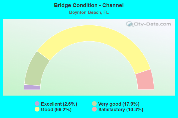
- Bridge Condition - Channel
- 2.6%Excellent
- 17.9%Very good
- 69.2%Good
- 10.3%Satisfactory
Find on map >> Show street view
Structure Number: 934981, Location: 0.4Mi. East of Congress A (Lat: 26.531750, Lng: -80.084167), Route carried "on" structure: County highway , Year Built: 2009, Status: Open, Structure Length: 2.03m (6.66ft), Average Daily Traffic: 18,500 (year 2020), Truck Traffic: 3%, Average Future Daily Traffic: 32,098 (year 2042), Design Load: HL 93, Features Intersected: E-4 Canal, Facility Carried by Structure: Old Boynton Road
Minimum Vertical Clearance: 30+ m (98+ ft), Kilometerpoint: 3.798, Lanes on structure: 3, Owner: County Highway Agency, Approaching Roadway Width: 13.7m (44.9ft), Material/Design: Prestressed concrete, Design/Construction: Stringer/Multi-beam, Number Of Spans In Main Unit: 1, Length of Maximum Span: 20.3m (66.6ft), Curb or Sidewalk Widths: Left: 2.0m (6.6ft), Right: 2.0m (6.6ft), Curb-To-Curb Width: 13.7m (44.9ft), Out-to-Out Width: 18.4m (60.4ft)
Condition: Deck: Very good, Superstructure: Very good, Substructure: Very good, Channel: Very good, Operating Rating: 44.5 metric tons, Method Used To Determine Operating Rating: Load and Resistance Factor (LRFR), Inventory Rating: 40.8 metric tons, Method Used To Determine Inventory Rating: Load and Resistance Factor (LRFR), Structural Evaluation: Equal to present desirable criteria, Deck Geometry: Somewhat better than minimum adequacy, Waterway Adequacy: Equal to present desirable criteria, Approach Roadway Alignment: Equal to present desirable criteria, Designated Inspection Frequency: Every 24 months, Underwater Inspection Frequency: Every 24 months, Inspection Date: Febuary 2020, Underwater Inspection Date: Febuary 2020, Deck Structure Type: Concrete Cast-file-Place
Find on map >> Show street view
Structure Number: 9353, Location: 0.4MI E OF CONGRESS AVE (Lat: 26.524361, Lng: -80.084233), Route carried "on" structure: City street , Year Built: 1969, Status: Posted for load-capacity, Structure Length: 3.82m (12.53ft), Average Daily Traffic: 2,600 (year 2021), Truck Traffic: 2%, Average Future Daily Traffic: 3,120 (year 2042), Design Load: HS 20, Features Intersected: LWDD E-4 CANAL, Facility Carried by Structure: WEST OCEAN DRIVE
Minimum Vertical Clearance: 30+ m (98+ ft), Kilometerpoint: 0.000, Lanes on structure: 2, Owner: City or Municipal Highway Agency, Approaching Roadway Width: 6.7m (22.0ft), Skew: 1 degrees, Material/Design: Prestressed concrete, Design/Construction: Slab, Number Of Spans In Main Unit: 5, Length of Maximum Span: 7.7m (25.3ft), Curb or Sidewalk Widths: Left: 1.2m (3.9ft), Right: 1.2m (3.9ft), Curb-To-Curb Width: 8.5m (27.9ft), Out-to-Out Width: 11.5m (37.7ft)
Condition: Deck: Good, Superstructure: Good, Substructure: Good, Channel: Good, Inventory Rating: 68.0 metric tons, Method Used To Determine Inventory Rating: Load Factor (LF), Structural Evaluation: Better than present minimum criteria, Deck Geometry: Meets minimum limits, Waterway Adequacy: Better than present minimum criteria, Approach Roadway Alignment: Equal to present desirable criteria, Designated Inspection Frequency: Every 24 months, Underwater Inspection Frequency: Every 24 months, Inspection Date: August 2021, Underwater Inspection Date: August 2021, Deck Structure Type: Concrete Precast Panels, Wearing Surface/Protective System: Wearing Surface: Bituminous
Find on map >> Show street view
Structure Number: 935301, Location: 0.1MI S OF OLD BOYNTON (Lat: 26.531275, Lng: -80.083592), Route carried "on" structure: City street , Year Built: 1956, Status: Posted for load, Structure Length: 0.76m (2.49ft), Average Daily Traffic: 1,000 (year 2021), Truck Traffic: 2%, Average Future Daily Traffic: 1,200 (year 2042), Features Intersected: SUBDIVISION CANAL, Facility Carried by Structure: CORAL DRIVE
Minimum Vertical Clearance: 30+ m (98+ ft), Kilometerpoint: 0.000, Lanes on structure: 2, Owner: City or Municipal Highway Agency, Approaching Roadway Width: 6.4m (21.0ft), Material/Design: Concrete, Design/Construction: Tee Beam, Number Of Spans In Main Unit: 1, Length of Maximum Span: 7.6m (24.9ft), Curb-To-Curb Width: 6.7m (22.0ft), Out-to-Out Width: 7.7m (25.3ft)
Condition: Deck: Good, Superstructure: Good, Substructure: Good, Channel: Good, Operating Rating: 25.5 metric tons, Method Used To Determine Operating Rating: Load Factor (LF), Inventory Rating: 15.3 metric tons, Method Used To Determine Inventory Rating: Load Factor (LF), Structural Evaluation: Meets minimum limits, Deck Geometry: Meets minimum limits, Waterway Adequacy: Equal to present desirable criteria, Approach Roadway Alignment: Equal to present desirable criteria, Bridge Posting: Required (Relationship of Operating Rating to Maximum Legal Load: > 39.9% below), Designated Inspection Frequency: Every 24 months, Other Special Inspection Frequency: Every 12 months, Inspection Date: August 2021, Other Special Inspection Date: August 2021, Deck Structure Type: Concrete Cast-file-Place, Wearing Surface/Protective System: Wearing Surface: Bituminous
Find on map >> Show street view
Structure Number: 935302, Location: 0.1MI S OF OLD BOYNTON (Lat: 26.531256, Lng: -80.084972), Route carried "on" structure: City street , Year Built: 1956, Status: Open, Structure Length: 0.76m (2.49ft), Average Daily Traffic: 364 (year 2021), Truck Traffic: 4%, Average Future Daily Traffic: 607 (year 2042), Features Intersected: SUBDIVISION CANAL, Facility Carried by Structure: VENICE DRIVE
Minimum Vertical Clearance: 30+ m (98+ ft), Kilometerpoint: 0.000, Lanes on structure: 2, Owner: City or Municipal Highway Agency, Approaching Roadway Width: 6.3m (20.7ft), Material/Design: Concrete, Design/Construction: Tee Beam, Number Of Spans In Main Unit: 1, Length of Maximum Span: 7.6m (24.9ft), Curb-To-Curb Width: 6.7m (22.0ft), Out-to-Out Width: 7.7m (25.3ft)
Condition: Deck: Good, Superstructure: Good, Substructure: Good, Channel: Good, Operating Rating: 50.5 metric tons, Method Used To Determine Operating Rating: Load Factor (LF), Inventory Rating: 30.3 metric tons, Method Used To Determine Inventory Rating: Load Factor (LF), Structural Evaluation: Better than present minimum criteria, Deck Geometry: Meets minimum limits, Waterway Adequacy: Equal to present desirable criteria, Approach Roadway Alignment: Equal to present desirable criteria, Designated Inspection Frequency: Every 24 months, Inspection Date: August 2021, Deck Structure Type: Concrete Cast-file-Place, Wearing Surface/Protective System: Wearing Surface: Bituminous
Find on map >> Show street view
Structure Number: 935303, Location: 200FT N of NW 22ND STR (Lat: 26.486439, Lng: -80.078811), Route carried "on" structure: City street , Year Built: 1955, Status: Open, Structure Length: 1.83m (6.00ft), Average Daily Traffic: 416 (year 2021), Truck Traffic: 2%, Average Future Daily Traffic: 694 (year 2042), Design Load: HS 20, Features Intersected: CANAL N. END LAKE IDA, Facility Carried by Structure: S. LAKE DRIVE
Minimum Vertical Clearance: 30+ m (98+ ft), Kilometerpoint: 0.000, Lanes on structure: 2, Owner: City or Municipal Highway Agency, Approaching Roadway Width: 6.0m (19.7ft), Material/Design: Concrete, Design/Construction: Tee Beam, Number Of Spans In Main Unit: 3, Length of Maximum Span: 6.1m (20.0ft), Curb-To-Curb Width: 6.6m (21.7ft), Out-to-Out Width: 7.4m (24.3ft)
Condition: Deck: Satisfactory, Superstructure: Good, Substructure: Satisfactory, Channel: Good, Operating Rating: 51.7 metric tons, Method Used To Determine Operating Rating: Load Factor (LF), Inventory Rating: 30.8 metric tons, Method Used To Determine Inventory Rating: Load Factor (LF), Structural Evaluation: Equal to present minimum criteria, Deck Geometry: High priority of corrective action, Waterway Adequacy: Equal to present minimum criteria, Approach Roadway Alignment: Equal to present minimum criteria, Designated Inspection Frequency: Every 24 months, Underwater Inspection Frequency: Every 24 months, Inspection Date: August 2021, Underwater Inspection Date: August 2021, Deck Structure Type: Concrete Cast-file-Place, Wearing Surface/Protective System: Wearing Surface: Bituminous
Find on map >> Show street view
Structure Number: 935305, Location: 100FT E OF SOUTH LAKE DR (Lat: 26.495556, Lng: -80.078014), Route carried "on" structure: City street , Year Built: 1958, Status: Posted for load-capacity, Structure Length: 1.86m (6.10ft), Average Daily Traffic: 936 (year 2021), Truck Traffic: 2%, Average Future Daily Traffic: 1,124 (year 2042), Design Load: HS 20, Features Intersected: CANAL E-4, Facility Carried by Structure: MISSION HILL ROAD
Minimum Vertical Clearance: 30+ m (98+ ft), Kilometerpoint: 0.000, Lanes on structure: 2, Owner: City or Municipal Highway Agency, Approaching Roadway Width: 6.1m (20.0ft), Material/Design: Concrete, Design/Construction: Stringer/Multi-beam, Number Of Spans In Main Unit: 3, Length of Maximum Span: 6.4m (21.0ft), Curb-To-Curb Width: 5.5m (18.0ft), Out-to-Out Width: 6.5m (21.3ft)
Condition: Deck: Satisfactory, Superstructure: Satisfactory, Substructure: Satisfactory, Channel: Good, Operating Rating: 51.7 metric tons, Method Used To Determine Operating Rating: Load Factor (LF), Inventory Rating: 30.8 metric tons, Method Used To Determine Inventory Rating: Load Factor (LF), Structural Evaluation: Equal to present minimum criteria, Deck Geometry: High priority of replacement, Waterway Adequacy: Better than present minimum criteria, Approach Roadway Alignment: Equal to present desirable criteria, Designated Inspection Frequency: Every 24 months, Inspection Date: August 2021, Deck Structure Type: Concrete Cast-file-Place, Wearing Surface/Protective System: Wearing Surface: Bituminous
Find on map >> Show street view
Structure Number: 935306, Location: 150 FT E of SW 10TH ST (Lat: 26.507103, Lng: -80.078725), Route carried "on" structure: City street , Year Built: 1952, Status: Posted for load, Structure Length: 1.86m (6.10ft), Average Daily Traffic: 101 (year 2021), Truck Traffic: 1%, Average Future Daily Traffic: 121 (year 2042), Design Load: HS 20, Features Intersected: LAKE IDA CANAL, Facility Carried by Structure: SW 22ND WAY
Minimum Vertical Clearance: 30+ m (98+ ft), Kilometerpoint: 0.000, Lanes on structure: 2, Owner: City or Municipal Highway Agency, Approaching Roadway Width: 6.7m (22.0ft), Material/Design: Concrete, Design/Construction: Box Beam or Girders - Single/Spread, Number Of Spans In Main Unit: 3, Length of Maximum Span: 6.3m (20.7ft), Curb or Sidewalk Widths: Left: 0.2m (0.7ft), Right: 0.2m (0.7ft), Curb-To-Curb Width: 6.7m (22.0ft), Out-to-Out Width: 7.7m (25.3ft)
Condition: Deck: Satisfactory, Superstructure: Satisfactory, Substructure: Satisfactory, Channel: Good, Operating Rating: 27.2 metric tons, Method Used To Determine Operating Rating: Load Factor (LF), Inventory Rating: 16.3 metric tons, Method Used To Determine Inventory Rating: Load Factor (LF), Structural Evaluation: Somewhat better than minimum adequacy, Deck Geometry: Meets minimum limits, Waterway Adequacy: Better than present minimum criteria, Approach Roadway Alignment: Equal to present desirable criteria, Bridge Posting: Required (Relationship of Operating Rating to Maximum Legal Load: 30.0 - 39.9% below), Designated Inspection Frequency: Every 24 months, Underwater Inspection Frequency: Every 24 months, Other Special Inspection Frequency: Every 12 months, Inspection Date: August 2021, Underwater Inspection Date: August 2021, Other Special Inspection Date: August 2021, Deck Structure Type: Concrete Cast-file-Place, Wearing Surface/Protective System: Wearing Surface: Bituminous
Find on map >> Show street view
Structure Number: 935307, Location: 0.3MI E OF CONGRESS BLVD (Lat: 26.546797, Lng: -80.085800), Route carried "on" structure: City street , Year Built: 1988, Status: Open, Structure Length: 3.05m (10.01ft), Average Daily Traffic: 18,000 (year 2021), Truck Traffic: 4%, Average Future Daily Traffic: 21,600 (year 2042), Design Load: HS 20, Features Intersected: CANAL E-4, Facility Carried by Structure: GATEWAY BLVD (WB)
Minimum Vertical Clearance: 30+ m (98+ ft), Kilometerpoint: 0.480, Lanes on structure: 3, Owner: City or Municipal Highway Agency, Approaching Roadway Width: 11.6m (38.1ft), Material/Design: Prestressed concrete, Design/Construction: Slab, Number Of Spans In Main Unit: 3, Length of Maximum Span: 10.7m (35.1ft), Curb or Sidewalk Widths: Left: 1.6m (5.2ft), Right: 0.0m, Curb-To-Curb Width: 12.5m (41.0ft), Out-to-Out Width: 15.2m (49.9ft)
Condition: Deck: Good, Superstructure: Good, Substructure: Good, Channel: Good, Operating Rating: 41.7 metric tons, Method Used To Determine Operating Rating: Allowable Stress (AS), Inventory Rating: 25.4 metric tons, Method Used To Determine Inventory Rating: Allowable Stress (AS), Structural Evaluation: Equal to present minimum criteria, Deck Geometry: Meets minimum limits, Waterway Adequacy: Better than present minimum criteria, Approach Roadway Alignment: Equal to present desirable criteria, Designated Inspection Frequency: Every 24 months, Underwater Inspection Frequency: Every 24 months, Inspection Date: August 2021, Underwater Inspection Date: August 2021, Deck Structure Type: Concrete Precast Panels
Find on map >> Show street view
Structure Number: 935308, Location: 0.3MI E OF CONGRESS BLVD (Lat: 26.546622, Lng: -80.085794), Route carried "on" structure: City street , Year Built: 1988, Status: Open, Structure Length: 3.05m (10.01ft), Average Daily Traffic: 18,000 (year 2021), Truck Traffic: 4%, Average Future Daily Traffic: 21,600 (year 2042), Design Load: HS 20, Features Intersected: CANAL E-4, Facility Carried by Structure: GATEWAY BLVD (EB)
Minimum Vertical Clearance: 30+ m (98+ ft), Kilometerpoint: 0.480, Lanes on structure: 3, Owner: City or Municipal Highway Agency, Approaching Roadway Width: 12.8m (42.0ft), Material/Design: Prestressed concrete, Design/Construction: Slab, Number Of Spans In Main Unit: 3, Length of Maximum Span: 10.7m (35.1ft), Curb or Sidewalk Widths: Left: 0.0m, Right: 2.5m (8.2ft), Curb-To-Curb Width: 13.1m (43.0ft), Out-to-Out Width: 16.9m (55.4ft)
Condition: Deck: Good, Superstructure: Good, Substructure: Good, Channel: Good, Operating Rating: 41.7 metric tons, Method Used To Determine Operating Rating: Allowable Stress (AS), Inventory Rating: 25.4 metric tons, Method Used To Determine Inventory Rating: Allowable Stress (AS), Structural Evaluation: Equal to present minimum criteria, Deck Geometry: Meets minimum limits, Waterway Adequacy: Better than present minimum criteria, Approach Roadway Alignment: Equal to present desirable criteria, Designated Inspection Frequency: Every 24 months, Underwater Inspection Frequency: Every 24 months, Inspection Date: August 2021, Underwater Inspection Date: August 2021, Deck Structure Type: Concrete Precast Panels
Find on map >> Show street view
Structure Number: 936375, Location: 0.19Mi. E of Congress Ave (Lat: 26.549028, Lng: -80.086167), Route carried "on" structure: City street , Year Built: 1988, Status: Open, Structure Length: 3.08m (10.10ft), Average Daily Traffic: 2,880 (year 2020), Truck Traffic: 1%, Average Future Daily Traffic: 3,600 (year 2042), Design Load: HL 93, Features Intersected: LWDD E-4 Canal, Facility Carried by Structure: Quantum Blvd.
Minimum Vertical Clearance: 30+ m (98+ ft), Kilometerpoint: 0.000, Lanes on structure: 4, Owner: City or Municipal Highway Agency, Approaching Roadway Width: 19.7m (64.6ft), Skew: 20 degrees, Material/Design: Prestressed concrete, Design/Construction: Slab, Number Of Spans In Main Unit: 3, Length of Maximum Span: 12.2m (40.0ft), Curb or Sidewalk Widths: Left: 1.5m (4.9ft), Right: 2.3m (7.5ft), Curb-To-Curb Width: 19.7m (64.6ft), Out-to-Out Width: 27.1m (88.9ft)
Condition: Deck: Good, Superstructure: Good, Substructure: Good, Channel: Good, Operating Rating: 30.4 metric tons, Method Used To Determine Operating Rating: Load and Resistance Factor (LRFR), Inventory Rating: 26.1 metric tons, Method Used To Determine Inventory Rating: Load and Resistance Factor (LRFR), Structural Evaluation: Equal to present minimum criteria, Deck Geometry: Better than present minimum criteria, Waterway Adequacy: Equal to present desirable criteria, Approach Roadway Alignment: Equal to present desirable criteria, Designated Inspection Frequency: Every 24 months, Underwater Inspection Frequency: Every 24 months, Inspection Date: October 2020, Underwater Inspection Date: October 2020, Deck Structure Type: Concrete Precast Panels, Wearing Surface/Protective System: Wearing Surface: Bituminous
Find on map >> Show street view
Structure Number: 930285, Location: 1 mile West of US 1 (Lat: 26.528911, Lng: -80.073094), Route carried "under" structure: Interstate 95, Year Built: 1976, Structure Length: 0. m, Average Daily Traffic: 196,000 (year 2020), Truck Traffic: 9%, Features Intersected: I 95 SR 9, Facility Carried by Structure: SR 804 Boyton B B
Minimum Vertical Clearance: 5.15m (16.90ft), Kilometerpoint: 23.770, Lanes on structure: 6, Lanes under structure: 10, Material/Design: Prestressed concrete, Design/Construction: Stringer/Multi-beam, Length of Maximum Span: 30.5m (100.1ft)
Find on map >> Show street view
Structure Number: 930301, Location: I 95 Exit 56 (Lat: 26.514517, Lng: -80.072203), Route carried "under" structure: Interstate 95, Year Built: 1975, Structure Length: 0. m, Average Daily Traffic: 179,596 (year 2020), Truck Traffic: 8%, Features Intersected: I 95 SR 9, Facility Carried by Structure: Woolbright Road
Minimum Vertical Clearance: 5.97m (19.59ft), Kilometerpoint: 22.169, Lanes on structure: 7, Lanes under structure: 10, Material/Design: Prestressed concrete, Design/Construction: Stringer/Multi-beam, Length of Maximum Span: 30.4m (99.7ft)
Find on map >> Show street view
Structure Number: 930304, Location: Over I 95 1 mi S of SR804 (Lat: 26.507700, Lng: -80.074750), Route carried "under" structure: Interstate 95, Year Built: 1975, Structure Length: 0. m, Average Daily Traffic: 179,596 (year 2020), Truck Traffic: 8%, Features Intersected: I 95 SR 9, Facility Carried by Structure: SW 23 Ave Golf Rd
Minimum Vertical Clearance: 5.85m (19.19ft), Kilometerpoint: 21.372, Lanes on structure: 2, Lanes under structure: 12, Material/Design: Prestressed concrete, Design/Construction: Stringer/Multi-beam, Length of Maximum Span: 36.3m (119.1ft)
Find on map >> Show street view
Structure Number: 930428, Location: 6.2 MILES SOUTH OF SR-802 (Lat: 26.528053, Lng: -80.172589), Route carried "under" structure: State highway 804, Year Built: 1992, Structure Length: 0. m, Average Daily Traffic: 36,000 (year 2021), Truck Traffic: 7%, Features Intersected: SR 804 BOYNTON BCH BLVD, Facility Carried by Structure: SR91 N/S TPK 87.3
Minimum Vertical Clearance: 5.18m (16.99ft), Kilometerpoint: 3.244, Lanes on structure: 9, Lanes under structure: 7, Toll: On toll road, Material/Design: Prestressed concrete, Design/Construction: Stringer/Multi-beam, Length of Maximum Span: 25.3m (83.0ft)
Find on map >> Show street view
Structure Number: 930434, Location: 1.5 miles North of SR 804 (Lat: 26.550583, Lng: -80.070111), Route carried "under" structure: Interstate 95, Year Built: 1992, Structure Length: 0. m, Average Daily Traffic: 234,000 (year 2021), Truck Traffic: 8%, Features Intersected: I 95 SR 9, Facility Carried by Structure: E Gateway Blvd
Minimum Vertical Clearance: 8.26m (27.10ft), Kilometerpoint: 26.202, Lanes on structure: 8, Lanes under structure: 10, Material/Design: Prestressed concrete, Design/Construction: Stringer/Multi-beam, Length of Maximum Span: 33.2m (108.9ft)
Find on map >> Show street view
Structure Number: 934468, Location: 0.7MI W OF CONGRESS AVE. (Lat: 26.513261, Lng: -80.102317), Route carried "under" structure: County highway , Year Built: 1991, Structure Length: 0. m, Average Daily Traffic: 101 (year 2020), Truck Traffic: 2%, Features Intersected: QUAIL COVEY ROAD, Facility Carried by Structure: Woolbright Road EB
Minimum Vertical Clearance: 4.50m (14.76ft), Kilometerpoint: 0.000, Lanes on structure: 2, Lanes under structure: 2, Material/Design: Prestressed concrete, Design/Construction: Stringer/Multi-beam, Length of Maximum Span: 17.7m (58.1ft)
Find on map >> Show street view
Structure Number: 934469, Location: 0.7MI W OF CONGRESS AVE (Lat: 26.513397, Lng: -80.102328), Route carried "under" structure: County highway , Year Built: 1991, Structure Length: 0. m, Average Daily Traffic: 101 (year 2020), Truck Traffic: 2%, Features Intersected: QUAIL COVEY ROAD, Facility Carried by Structure: Woolbright Road WB
Minimum Vertical Clearance: 4.56m (14.96ft), Kilometerpoint: 0.000, Lanes on structure: 2, Lanes under structure: 2, Material/Design: Prestressed concrete, Design/Construction: Stringer/Multi-beam, Length of Maximum Span: 17.7m (58.1ft)