Bridge Statistics for Brookhaven, Mississippi (MS)
Condition, Traffic, Stress, Structural Evaluation, Project Costs
- National Bridge Inventory (NBI) Statistics
- 104Number of bridges
- 1,089ft / 332mTotal length
- $7,837,302,000Total costs
- 444,920Total average daily traffic
- 85,483Total average daily truck traffic
- National Bridge Inventory (NBI) Registered Bridges for Brookhaven
- No street view available for this location
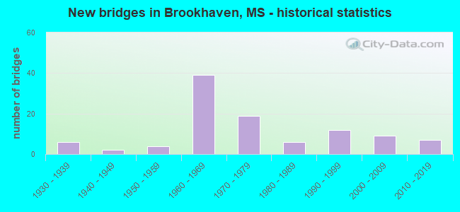
- New bridges - historical statistics
- 61930-1939
- 21940-1949
- 41950-1959
- 391960-1969
- 191970-1979
- 61980-1989
- 121990-1999
- 92000-2009
- 72010-2019
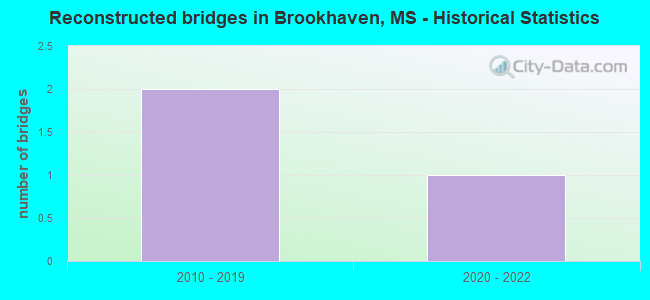
- Reconstructed bridges - Historical Statistics
- 22010-2019
- 12020-2022
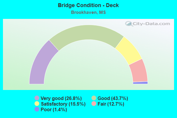
- Bridge Condition - Deck
- 26.8%Very good
- 43.7%Good
- 15.5%Satisfactory
- 12.7%Fair
- 1.4%Poor
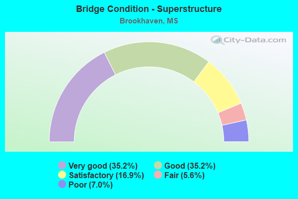
- Bridge Condition - Superstructure
- 35.2%Very good
- 35.2%Good
- 16.9%Satisfactory
- 5.6%Fair
- 7.0%Poor
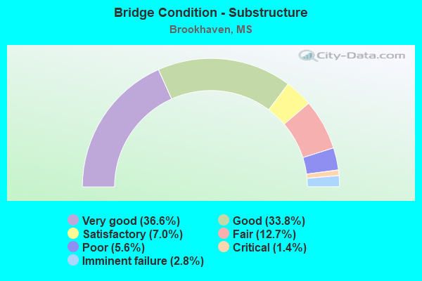
- Bridge Condition - Substructure
- 36.6%Very good
- 33.8%Good
- 7.0%Satisfactory
- 12.7%Fair
- 5.6%Poor
- 1.4%Critical
- 2.8%Imminent failure
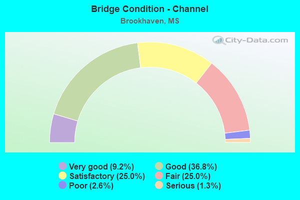
- Bridge Condition - Channel
- 9.2%Very good
- 36.8%Good
- 25.0%Satisfactory
- 25.0%Fair
- 2.6%Poor
- 1.3%Serious
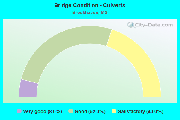
- Bridge Condition - Culverts
- 8.0%Very good
- 52.0%Good
- 40.0%Satisfactory
Find on map >> Show street view
Structure Number: SA430000000027, Location: SEC 35 T 8N R 8E (Lat: 31.615806, Lng: -90.368000), Route carried "on" structure: County highway 103, Year Built: 1972, Status: Temporarily open, Structure Length: 1.74m (5.71ft), Average Daily Traffic: 150 (year 2021), Truck Traffic: 8%, Average Future Daily Traffic: 165 (year 2042), Design Load: H 15, Features Intersected: LITTLE FAIR RIVER, Facility Carried by Structure: BEESON ROAD
Minimum Vertical Clearance: 30+ m (98+ ft), Kilometerpoint: 8.046, Lanes on structure: 2, Owner: County Highway Agency, Approaching Roadway Width: 6.7m (22.0ft), Material/Design: Concrete, Design/Construction: Channel Beam, Number Of Spans In Main Unit: 3, Length of Maximum Span: 5.8m (19.0ft), Curb or Sidewalk Widths: Left: 0.2m (0.7ft), Right: 0.2m (0.7ft), Curb-To-Curb Width: 7.1m (23.3ft), Out-to-Out Width: 7.6m (24.9ft)
Condition: Deck: Very good, Superstructure: Very good, Substructure: Imminent failure, Channel: Good, Deck Geometry: Meets minimum limits, Approach Roadway Alignment: Equal to present desirable criteria, Bridge Posting: Required (Relationship of Operating Rating to Maximum Legal Load: > 39.9% below), Length Of Structure Improvement: 1.74m (5.71ft), Designated Inspection Frequency: Every 12 months, Inspection Date: September 2021, Bridge Improvement Cost: $55,000, Roadway Improvement Cost: $25,000, Total Project Cost: $89,000, Deck Structure Type: Concrete Precast Panels, Wearing Surface/Protective System: Wearing Surface: Bituminous
Find on map >> Show street view
Structure Number: SA4300000000271, Location: SEC 36 T 8N R 8E B (Lat: 31.615972, Lng: -90.358278), Route carried "on" structure: County highway 116, Year Built: 1969, Status: Posted for load, Structure Length: 1.74m (5.71ft), Average Daily Traffic: 400 (year 2019), Truck Traffic: 8%, Average Future Daily Traffic: 440 (year 2041), Design Load: H 15, Features Intersected: LITTLE FAIR RIVER, Facility Carried by Structure: CALLENDER RD NE
Minimum Vertical Clearance: 30+ m (98+ ft), Kilometerpoint: 0.804, Lanes on structure: 2, Owner: County Highway Agency, Approaching Roadway Width: 6.7m (22.0ft), Material/Design: Concrete, Design/Construction: Channel Beam, Number Of Spans In Main Unit: 3, Length of Maximum Span: 5.8m (19.0ft), Curb or Sidewalk Widths: Left: 0.2m (0.7ft), Right: 0.2m (0.7ft), Curb-To-Curb Width: 7.1m (23.3ft), Out-to-Out Width: 7.6m (24.9ft)
Condition: Deck: Fair, Superstructure: Poor, Substructure: Fair, Channel: Good, Operating Rating: 8.0 metric tons, Method Used To Determine Operating Rating: Load Factor (LF), Inventory Rating: 4.8 metric tons, Method Used To Determine Inventory Rating: Load Factor (LF), Structural Evaluation: High priority of replacement, Deck Geometry: Meets minimum limits, Waterway Adequacy: Better than present minimum criteria, Approach Roadway Alignment: Equal to present desirable criteria, Bridge Posting: Required (Relationship of Operating Rating to Maximum Legal Load: > 39.9% below), Length Of Structure Improvement: 1.74m (5.71ft), Designated Inspection Frequency: Every 12 months, Inspection Date: October 2021, Bridge Improvement Cost: $55,000, Roadway Improvement Cost: $25,000, Total Project Cost: $89,000, Deck Structure Type: Concrete Precast Panels
Find on map >> Show street view
Structure Number: SA4300000000301, Location: SEC 6 T 7N R 8E (Lat: 31.610556, Lng: -90.434722), Route carried "on" structure: County highway 1114, Year Built: 1978, Status: Posted for load, Structure Length: 0.94m (3.08ft), Average Daily Traffic: 200 (year 2013), Truck Traffic: 8%, Average Future Daily Traffic: 300 (year 2034), Design Load: H 15, Features Intersected: TRIB E BOGUE CHITTO RIV, Facility Carried by Structure: BRIGNAL ROAD
Minimum Vertical Clearance: 30+ m (98+ ft), Kilometerpoint: 1.448, Lanes on structure: 2, Owner: County Highway Agency, Approaching Roadway Width: 7.3m (24.0ft), Material/Design: Concrete, Design/Construction: Channel Beam, Number Of Spans In Main Unit: 1, Length of Maximum Span: 9.4m (30.8ft), Curb or Sidewalk Widths: Left: 0.2m (0.7ft), Right: 0.2m (0.7ft), Curb-To-Curb Width: 7.1m (23.3ft), Out-to-Out Width: 7.5m (24.6ft)
Condition: Deck: Fair, Superstructure: Fair, Substructure: Satisfactory, Channel: Satisfactory, Operating Rating: 31.1 metric tons, Method Used To Determine Operating Rating: Load Factor (LF), Inventory Rating: 18.7 metric tons, Method Used To Determine Inventory Rating: Load Factor (LF), Structural Evaluation: Somewhat better than minimum adequacy, Deck Geometry: Meets minimum limits, Waterway Adequacy: Better than present minimum criteria, Approach Roadway Alignment: Equal to present desirable criteria, Bridge Posting: Required (Relationship of Operating Rating to Maximum Legal Load: 10.0 - 19.9% below), Length Of Structure Improvement: 1.74m (5.71ft), Designated Inspection Frequency: Every 24 months, Inspection Date: October 2021, Bridge Improvement Cost: $64,000, Roadway Improvement Cost: $15,000, Total Project Cost: $88,000, Deck Structure Type: Concrete Precast Panels
Find on map >> Show street view
Structure Number: SA4300000000302, Location: SEC 6 T 7N R 8E B (Lat: 31.599444, Lng: -90.435750), Route carried "on" structure: City street , Year Built: 2000, Status: Open, Structure Length: 34.12m (111.94ft), Average Daily Traffic: 3,000 (year 2013), Truck Traffic: 20%, Average Future Daily Traffic: 4,500 (year 2035), Design Load: HS 20, Features Intersected: CN RR BRIGNALL RD 1ST ST, Facility Carried by Structure: INDUSTRIAL PARK RD
Minimum Vertical Clearance: 6.90m (22.64ft), Kilometerpoint: 0.825, Lanes on structure: 2, Lanes under structure: 4, Owner: City or Municipal Highway Agency, Approaching Roadway Width: 12.3m (40.4ft), Material/Design: Prestressed concrete, Design/Construction: Stringer/Multi-beam, Number Of Spans In Main Unit: 23, Length of Maximum Span: 33.5m (109.9ft), Curb or Sidewalk Widths: Left: 0.2m (0.7ft), Right: 0.2m (0.7ft), Curb-To-Curb Width: 12.3m (40.4ft), Out-to-Out Width: 13.2m (43.3ft)
Condition: Deck: Good, Superstructure: Good, Substructure: Good, Operating Rating: 64.4 metric tons, Method Used To Determine Operating Rating: Load Factor (LF), Inventory Rating: 22.7 metric tons, Method Used To Determine Inventory Rating: Load Factor (LF), Structural Evaluation: Equal to present minimum criteria, Deck Geometry: Equal to present minimum criteria, Underclear: Better than present minimum criteria, Approach Roadway Alignment: Equal to present desirable criteria, Designated Inspection Frequency: Every 24 months, Inspection Date: March 2020, Deck Structure Type: Concrete Cast-file-Place, Wearing Surface/Protective System: Wearing Surface: Monolithic Concrete
Find on map >> Show street view
Structure Number: SA4300000000309, Location: SEC 1 T 7N R 7E (Lat: 31.605542, Lng: -90.455428), Route carried "on" structure: County highway 109, Year Built: 2009, Status: Open, Structure Length: 2.83m (9.28ft), Average Daily Traffic: 155 (year 2021), Truck Traffic: 8%, Average Future Daily Traffic: 225 (year 2041), Design Load: HS 20, Features Intersected: WEST BOGUE CHITTO RIVER, Facility Carried by Structure: FIELD LARK LANE
Minimum Vertical Clearance: 30+ m (98+ ft), Kilometerpoint: 1.448, Lanes on structure: 2, Owner: County Highway Agency, Approaching Roadway Width: 6.7m (22.0ft), Material/Design: Concrete, Design/Construction: Channel Beam, Number Of Spans In Main Unit: 3, Length of Maximum Span: 9.4m (30.8ft), Curb or Sidewalk Widths: Left: 0.2m (0.7ft), Right: 0.2m (0.7ft), Curb-To-Curb Width: 8.1m (26.6ft), Out-to-Out Width: 8.5m (27.9ft)
Condition: Deck: Good, Superstructure: Good, Substructure: Very good, Channel: Satisfactory, Operating Rating: 93.4 metric tons, Method Used To Determine Operating Rating: Load Factor (LF), Inventory Rating: 55.9 metric tons, Method Used To Determine Inventory Rating: Load Factor (LF), Structural Evaluation: Better than present minimum criteria, Deck Geometry: Somewhat better than minimum adequacy, Waterway Adequacy: Equal to present desirable criteria, Approach Roadway Alignment: Equal to present desirable criteria, Designated Inspection Frequency: Every 24 months, Inspection Date: October 2021, Deck Structure Type: Concrete Precast Panels
Find on map >> Show street view
Structure Number: SA4300000000311, Location: SEC 10 T 7N R 7E (Lat: 31.593639, Lng: -90.494028), Route carried "on" structure: County highway 248, Year Built: 2003, Year Reconstructed: 2020, Status: Open, Structure Length: 0.94m (3.08ft), Average Daily Traffic: 500 (year 2019), Truck Traffic: 10%, Average Future Daily Traffic: 570 (year 2041), Design Load: H 15, Features Intersected: TRIB OF BOGUE CHITTO RIV, Facility Carried by Structure: CALIFORNIA RD NW
Minimum Vertical Clearance: 30+ m (98+ ft), Kilometerpoint: 7.886, Lanes on structure: 2, Owner: County Highway Agency, Approaching Roadway Width: 6.7m (22.0ft), Material/Design: Concrete, Design/Construction: Channel Beam, Number Of Spans In Main Unit: 1, Length of Maximum Span: 9.4m (30.8ft), Curb or Sidewalk Widths: Left: 0.2m (0.7ft), Right: 0.2m (0.7ft), Curb-To-Curb Width: 7.1m (23.3ft), Out-to-Out Width: 7.5m (24.6ft)
Condition: Deck: Good, Superstructure: Satisfactory, Substructure: Good, Channel: Good, Operating Rating: 55.2 metric tons, Method Used To Determine Operating Rating: Load Factor (LF), Inventory Rating: 33.0 metric tons, Method Used To Determine Inventory Rating: Load Factor (LF), Structural Evaluation: Equal to present minimum criteria, Deck Geometry: Meets minimum limits, Waterway Adequacy: Better than present minimum criteria, Approach Roadway Alignment: Equal to present minimum criteria, Length Of Structure Improvement: 1.52m (4.99ft), Designated Inspection Frequency: Every 24 months, Inspection Date: January 2022, Bridge Improvement Cost: $49,000, Roadway Improvement Cost: $20,000, Total Project Cost: $77,000, Deck Structure Type: Concrete Precast Panels
Find on map >> Show street view
Structure Number: SA4300000000314, Location: SEC 10 T 6N R 8E (Lat: 31.503528, Lng: -90.383028), Route carried "on" structure: County highway 141, Year Built: 2007, Status: Open, Structure Length: 1.16m (3.81ft), Average Daily Traffic: 60 (year 2022), Average Future Daily Traffic: 90 (year 2043), Design Load: HS 20, Features Intersected: BOONE CREEK, Facility Carried by Structure: DOUGLAS TR SE
Minimum Vertical Clearance: 30+ m (98+ ft), Kilometerpoint: 4.506, Lanes on structure: 2, Owner: County Highway Agency, Approaching Roadway Width: 6.1m (20.0ft), Material/Design: Concrete, Design/Construction: Channel Beam, Number Of Spans In Main Unit: 2, Length of Maximum Span: 5.8m (19.0ft), Curb or Sidewalk Widths: Left: 0.2m (0.7ft), Right: 0.2m (0.7ft), Curb-To-Curb Width: 7.1m (23.3ft), Out-to-Out Width: 7.5m (24.6ft)
Condition: Deck: Good, Superstructure: Good, Substructure: Good, Channel: Very good, Operating Rating: 89.5 metric tons, Method Used To Determine Operating Rating: Load Factor (LF), Inventory Rating: 53.6 metric tons, Method Used To Determine Inventory Rating: Load Factor (LF), Structural Evaluation: Better than present minimum criteria, Deck Geometry: Somewhat better than minimum adequacy, Waterway Adequacy: Equal to present desirable criteria, Approach Roadway Alignment: Equal to present minimum criteria, Length Of Structure Improvement: 1.16m (3.81ft), Designated Inspection Frequency: Every 24 months, Inspection Date: January 2022, Bridge Improvement Cost: $17,000, Roadway Improvement Cost: $10,000, Total Project Cost: $29,000, Deck Structure Type: Concrete Precast Panels, Wearing Surface/Protective System: Wearing Surface: Bituminous
Find on map >> Show street view
Structure Number: SA4300000000326, Location: SEC 28 T 7N R 7E (Lat: 31.552483, Lng: -90.501861), Route carried "on" structure: County highway 227, Year Built: 2011, Status: Open, Structure Length: 2.47m (8.10ft), Average Daily Traffic: 1,000 (year 2019), Truck Traffic: 8%, Average Future Daily Traffic: 1,125 (year 2041), Design Load: HL 93, Features Intersected: DOOLITTLE CREEK, Facility Carried by Structure: FERN LN NW
Minimum Vertical Clearance: 30+ m (98+ ft), Kilometerpoint: 0.804, Lanes on structure: 2, Owner: County Highway Agency, Approaching Roadway Width: 8.5m (27.9ft), Material/Design: Concrete, Design/Construction: Channel Beam, Number Of Spans In Main Unit: 3, Length of Maximum Span: 9.4m (30.8ft), Curb or Sidewalk Widths: Left: 0.2m (0.7ft), Right: 0.2m (0.7ft), Curb-To-Curb Width: 8.5m (27.9ft), Out-to-Out Width: 8.9m (29.2ft)
Condition: Deck: Very good, Superstructure: Very good, Substructure: Very good, Channel: Very good, Operating Rating: 43.7 metric tons, Method Used To Determine Operating Rating: Load and Resistance Factor Rating (LRFR) rating reported by rating factor(RF) method using HL-93 loadings, Inventory Rating: 33.7 metric tons, Method Used To Determine Inventory Rating: Load and Resistance Factor Rating (LRFR) rating reported by rating factor(RF) method using HL-93 loadings, Structural Evaluation: Equal to present desirable criteria, Deck Geometry: Somewhat better than minimum adequacy, Waterway Adequacy: Equal to present desirable criteria, Approach Roadway Alignment: Equal to present desirable criteria, Designated Inspection Frequency: Every 24 months, Inspection Date: November 2021, Deck Structure Type: Concrete Precast Panels
Find on map >> Show street view
Structure Number: SA4300000000327, Location: SEC 19 T 8N R 8E (Lat: 31.655889, Lng: -90.439583), Route carried "on" structure: County highway 105, Year Built: 2012, Status: Open, Structure Length: 2.83m (9.28ft), Average Daily Traffic: 40 (year 2010), Average Future Daily Traffic: 60 (year 2030), Design Load: HL 93, Features Intersected: TRIBUTARY BAYOU PIERRE, Facility Carried by Structure: FOREST TRL NE
Minimum Vertical Clearance: 30+ m (98+ ft), Kilometerpoint: 0.804, Lanes on structure: 2, Owner: County Highway Agency, Approaching Roadway Width: 8.5m (27.9ft), Material/Design: Concrete, Design/Construction: Channel Beam, Number Of Spans In Main Unit: 3, Length of Maximum Span: 9.4m (30.8ft), Curb or Sidewalk Widths: Left: 0.2m (0.7ft), Right: 0.2m (0.7ft), Curb-To-Curb Width: 8.5m (27.9ft), Out-to-Out Width: 8.9m (29.2ft)
Condition: Deck: Very good, Superstructure: Very good, Substructure: Good, Channel: Good, Operating Rating: 43.7 metric tons, Method Used To Determine Operating Rating: Load and Resistance Factor Rating (LRFR) rating reported by rating factor(RF) method using HL-93 loadings, Inventory Rating: 33.7 metric tons, Method Used To Determine Inventory Rating: Load and Resistance Factor Rating (LRFR) rating reported by rating factor(RF) method using HL-93 loadings, Structural Evaluation: Better than present minimum criteria, Deck Geometry: Better than present minimum criteria, Waterway Adequacy: Equal to present desirable criteria, Approach Roadway Alignment: Equal to present desirable criteria, Designated Inspection Frequency: Every 24 months, Inspection Date: January 2021, Deck Structure Type: Concrete Precast Panels
Find on map >> Show street view
Structure Number: SA4300000000334, Location: SEC 16 T 7N R 7E (Lat: 31.582711, Lng: -90.504517), Route carried "on" structure: County highway , Year Built: 1979, Status: Posted for load, Structure Length: 1.83m (6.00ft), Average Daily Traffic: 20 (year 2019), Average Future Daily Traffic: 30 (year 2039), Design Load: H 10, Features Intersected: DRAINAGE, Facility Carried by Structure: OPELOUSA LN NW
Minimum Vertical Clearance: 30+ m (98+ ft), Kilometerpoint: 2.600, Lanes on structure: 2, Owner: County Highway Agency, Approaching Roadway Width: 5.9m (19.4ft), Material/Design: Wood or Timber, Design/Construction: Stringer/Multi-beam, Number Of Spans In Main Unit: 3, Length of Maximum Span: 6.1m (20.0ft), Curb-To-Curb Width: 6.3m (20.7ft), Out-to-Out Width: 6.3m (20.7ft)
Condition: Deck: Satisfactory, Superstructure: Poor, Substructure: Fair, Channel: Fair, Operating Rating: 11.8 metric tons, Method Used To Determine Operating Rating: Allowable Stress (AS), Inventory Rating: 8.5 metric tons, Method Used To Determine Inventory Rating: Allowable Stress (AS), Structural Evaluation: High priority of corrective action, Deck Geometry: Somewhat better than minimum adequacy, Waterway Adequacy: Equal to present desirable criteria, Approach Roadway Alignment: Equal to present minimum criteria, Bridge Posting: Required (Relationship of Operating Rating to Maximum Legal Load: > 39.9% below), Designated Inspection Frequency: Every 12 months, Inspection Date: October 2021, Deck Structure Type: Wood or Timber
Find on map >> Show street view
Structure Number: SA4300000000336, Location: SEC 7 T 6N R 8E (Lat: 31.507683, Lng: -90.441125), Route carried "on" structure: County highway 431, Year Built: 2017, Status: Open, Structure Length: 1.16m (3.81ft), Average Daily Traffic: 45 (year 2021), Average Future Daily Traffic: 50 (year 2040), Design Load: HS 20, Features Intersected: DRAIN, Facility Carried by Structure: MARWOOD LOOP SE
Minimum Vertical Clearance: 30+ m (98+ ft), Kilometerpoint: 0.482, Lanes on structure: 2, Owner: County Highway Agency, Approaching Roadway Width: 7.2m (23.6ft), Material/Design: Concrete, Design/Construction: Channel Beam, Number Of Spans In Main Unit: 2, Length of Maximum Span: 5.8m (19.0ft), Curb or Sidewalk Widths: Left: 0.2m (0.7ft), Right: 0.2m (0.7ft), Curb-To-Curb Width: 7.2m (23.6ft), Out-to-Out Width: 7.3m (24.0ft)
Condition: Deck: Satisfactory, Superstructure: Good, Substructure: Good, Channel: Good, Operating Rating: 89.5 metric tons, Method Used To Determine Operating Rating: Load Factor (LF), Inventory Rating: 53.6 metric tons, Method Used To Determine Inventory Rating: Load Factor (LF), Structural Evaluation: Better than present minimum criteria, Deck Geometry: Somewhat better than minimum adequacy, Waterway Adequacy: Equal to present desirable criteria, Approach Roadway Alignment: Equal to present desirable criteria, Designated Inspection Frequency: Every 24 months, Inspection Date: Febuary 2021, Deck Structure Type: Concrete Precast Panels
Find on map >> Show street view
Structure Number: SA430000000A18, Location: SEC 28 T 7N R 7E (Lat: 31.545106, Lng: -90.511314), Route carried "on" structure: Alternate County highway , Year Built: 2019, Status: Open, Structure Length: 1.61m (5.28ft), Average Daily Traffic: 50 (year 2021), Truck Traffic: 8%, Average Future Daily Traffic: 75 (year 2043), Design Load: HL 93, Features Intersected: DOOLITTLE CREEK, Facility Carried by Structure: ROLLINS DR NW
Minimum Vertical Clearance: 30+ m (98+ ft), Kilometerpoint: 1.287, Lanes on structure: 2, Owner: County Highway Agency, Approaching Roadway Width: 6.1m (20.0ft), Skew: 1 degrees, Material/Design: Concrete, Design/Construction: Culvert, Number Of Spans In Main Unit: 3, Length of Maximum Span: 4.9m (16.1ft)
Condition: Channel: Good, Culverts: Very good, Operating Rating: 97.2 metric tons, Method Used To Determine Operating Rating: Load and Resistance Factor Rating (LRFR) rating reported by rating factor(RF) method using HL-93 loadings, Inventory Rating: 79.1 metric tons, Method Used To Determine Inventory Rating: Load and Resistance Factor Rating (LRFR) rating reported by rating factor(RF) method using HL-93 loadings, Structural Evaluation: Equal to present desirable criteria, Waterway Adequacy: Equal to present desirable criteria, Approach Roadway Alignment: Better than present minimum criteria, Length Of Structure Improvement: 1.83m (6.00ft), Designated Inspection Frequency: Every 24 months, Inspection Date: October 2020, Bridge Improvement Cost: $300,000, Roadway Improvement Cost: $50,000, Total Project Cost: $350,000 ( Estimate for 2021)
Find on map >> Show street view
Structure Number: SA430000000A19, Location: SEC 17 T 7N R 8E (Lat: 31.581194, Lng: -90.421981), Route carried "on" structure: County highway 119, Year Built: 2019, Status: Open, Structure Length: 2.10m (6.89ft), Average Daily Traffic: 275 (year 2021), Truck Traffic: 8%, Average Future Daily Traffic: 360 (year 2043), Design Load: HL 93, Features Intersected: TRIB E BOGUE CHITTO RIV, Facility Carried by Structure: WILLIAMS ST NE
Minimum Vertical Clearance: 30+ m (98+ ft), Kilometerpoint: 0.804, Lanes on structure: 2, Owner: City or Municipal Highway Agency, Approaching Roadway Width: 6.7m (22.0ft), Material/Design: Concrete, Design/Construction: Channel Beam, Number Of Spans In Main Unit: 3, Length of Maximum Span: 9.4m (30.8ft), Curb or Sidewalk Widths: Left: 0.2m (0.7ft), Right: 0.2m (0.7ft), Curb-To-Curb Width: 8.2m (26.9ft), Out-to-Out Width: 8.6m (28.2ft)
Condition: Deck: Good, Superstructure: Satisfactory, Substructure: Good, Channel: Very good, Operating Rating: 43.7 metric tons, Method Used To Determine Operating Rating: Load and Resistance Factor Rating (LRFR) rating reported by rating factor(RF) method using HL-93 loadings, Inventory Rating: 33.7 metric tons, Method Used To Determine Inventory Rating: Load and Resistance Factor Rating (LRFR) rating reported by rating factor(RF) method using HL-93 loadings, Structural Evaluation: Equal to present minimum criteria, Deck Geometry: Somewhat better than minimum adequacy, Waterway Adequacy: Superior to present desirable criteria, Approach Roadway Alignment: Equal to present desirable criteria, Designated Inspection Frequency: Every 24 months, Inspection Date: September 2021, Deck Structure Type: Concrete Precast Panels, Wearing Surface/Protective System: Wearing Surface: Bituminous
Find on map >> Show street view
Structure Number: SA430000000A303, Location: SEC 19 T 7N R 8E (Lat: 31.560083, Lng: -90.436139), Route carried "on" structure: County highway 182, Year Built: 2014, Status: Open, Structure Length: 0.62m (2.03ft), Average Daily Traffic: 80 (year 2021), Truck Traffic: 10%, Average Future Daily Traffic: 100 (year 2042), Features Intersected: BRANCH OF E BOGUE CHITTO, Facility Carried by Structure: WASHINGTON ST NE
Minimum Vertical Clearance: 30+ m (98+ ft), Kilometerpoint: 1.125, Lanes on structure: 2, Owner: City or Municipal Highway Agency, Approaching Roadway Width: 5.4m (17.7ft), Material/Design: Steel, Design/Construction: Culvert, Number Of Spans In Main Unit: 2, Length of Maximum Span: 2.9m (9.5ft)
Condition: Channel: Fair, Culverts: Good, Operating Rating: 43.2 metric tons, Method Used To Determine Operating Rating: Field evaluation and documented engineering judgment, Inventory Rating: 35.6 metric tons, Method Used To Determine Inventory Rating: Field evaluation and documented engineering judgment, Structural Evaluation: Better than present minimum criteria, Waterway Adequacy: Better than present minimum criteria, Approach Roadway Alignment: Better than present minimum criteria, Designated Inspection Frequency: Every 24 months, Inspection Date: January 2021
Find on map >> Show street view
Structure Number: 11000550430375A, Location: I 55 OVER US 84 (Lat: 31.542319, Lng: -90.479969), Route carried "under" structure: US 84, Year Built: 1966, Structure Length: 0. m, Average Daily Traffic: 3,700 (year 2017), Truck Traffic: 8%, Features Intersected: US 84, Facility Carried by Structure: I 55
Minimum Vertical Clearance: 5.40m (17.72ft), Kilometerpoint: 22.664, Lanes on structure: 2, Lanes under structure: 4, Material/Design: Concrete continuous, Design/Construction: Box Beam or Girders - Single/Spread, Length of Maximum Span: 25.3m (83.0ft)
Find on map >> Show street view
Structure Number: 11000550430375A, Location: I 55 OVER US 84 (Lat: 31.542069, Lng: -90.479969), Route carried "under" structure: US 84, Year Built: 1966, Structure Length: 0. m, Average Daily Traffic: 3,700 (year 2017), Truck Traffic: 8%, Features Intersected: US 84, Facility Carried by Structure: I 55
Minimum Vertical Clearance: 5.83m (19.13ft), Kilometerpoint: 15.226, Lanes on structure: 2, Lanes under structure: 4, Material/Design: Concrete continuous, Design/Construction: Box Beam or Girders - Single/Spread, Length of Maximum Span: 25.3m (83.0ft)
Find on map >> Show street view
Structure Number: 11000550430375B, Location: I 55 OVER US 84 (Lat: 31.542519, Lng: -90.479689), Route carried "under" structure: US 84, Year Built: 1966, Structure Length: 0. m, Average Daily Traffic: 3,700 (year 2017), Truck Traffic: 10%, Features Intersected: US 84, Facility Carried by Structure: I 55
Minimum Vertical Clearance: 5.03m (16.50ft), Kilometerpoint: 22.629, Lanes on structure: 2, Lanes under structure: 4, Material/Design: Concrete continuous, Design/Construction: Box Beam or Girders - Single/Spread, Length of Maximum Span: 25.3m (83.0ft)
Find on map >> Show street view
Structure Number: 11000550430375B, Location: I 55 OVER US 84 (Lat: 31.542281, Lng: -90.479689), Route carried "under" structure: US 84, Year Built: 1966, Structure Length: 0. m, Average Daily Traffic: 3,700 (year 2017), Truck Traffic: 10%, Features Intersected: US 84, Facility Carried by Structure: I 55
Minimum Vertical Clearance: 5.44m (17.85ft), Kilometerpoint: 15.261, Lanes on structure: 2, Lanes under structure: 4, Material/Design: Concrete continuous, Design/Construction: Box Beam or Girders - Single/Spread, Length of Maximum Span: 25.3m (83.0ft)
Find on map >> Show street view
Structure Number: 11000550430407A, Location: I 55 OVER SR 550 (Lat: 31.588550, Lng: -90.470619), Route carried "under" structure: State highway 550, Year Built: 1966, Structure Length: 0. m, Average Daily Traffic: 5,300 (year 2017), Truck Traffic: 3%, Features Intersected: SR 550, Facility Carried by Structure: I 55
Minimum Vertical Clearance: 4.74m (15.55ft), Kilometerpoint: 29.094, Lanes on structure: 2, Lanes under structure: 2, Material/Design: Prestressed concrete, Design/Construction: Stringer/Multi-beam, Length of Maximum Span: 18.3m (60.0ft)
Find on map >> Show street view
Structure Number: 11000550430407B, Location: I 55 OVER SR 550 (Lat: 31.588361, Lng: -90.470381), Route carried "under" structure: State highway 550, Year Built: 1966, Structure Length: 0. m, Average Daily Traffic: 5,300 (year 2017), Truck Traffic: 8%, Features Intersected: SR 550, Facility Carried by Structure: I 55
Minimum Vertical Clearance: 5.07m (16.63ft), Kilometerpoint: 29.124, Lanes on structure: 2, Lanes under structure: 2, Material/Design: Prestressed concrete, Design/Construction: Stringer/Multi-beam, Length of Maximum Span: 18.3m (60.0ft)
Find on map >> Show street view
Structure Number: 41000550430358, Location: 11.4 MI N PIKE CL (Lat: 31.517142, Lng: -90.479550), Route carried "under" structure: Interstate 55, Year Built: 1966, Structure Length: 0. m, Average Daily Traffic: 10,500 (year 2017), Truck Traffic: 10%, Features Intersected: I 55, Facility Carried by Structure: KATIE DUNN ROAD
Minimum Vertical Clearance: 5.26m (17.26ft), Kilometerpoint: 1.653, Lanes on structure: 2, Lanes under structure: 4, Material/Design: Prestressed concrete, Design/Construction: Stringer/Multi-beam, Length of Maximum Span: 21.3m (69.9ft)
Find on map >> Show street view
Structure Number: 41000550430358, Location: 11.4 MI N PIKE CL (Lat: 31.517142, Lng: -90.479550), Route carried "under" structure: Interstate 55, Year Built: 1966, Structure Length: 0. m, Average Daily Traffic: 9,000 (year 2017), Truck Traffic: 10%, Features Intersected: I 55, Facility Carried by Structure: KATIE DUNN ROAD
Minimum Vertical Clearance: 5.10m (16.73ft), Kilometerpoint: 1.653, Lanes on structure: 2, Lanes under structure: 4, Material/Design: Prestressed concrete, Design/Construction: Stringer/Multi-beam, Length of Maximum Span: 21.3m (69.9ft)