Bridge Statistics for Castle Rock, Colorado (CO)
Condition, Traffic, Stress, Structural Evaluation, Project Costs
- National Bridge Inventory (NBI) Statistics
- 64Number of bridges
- 1,119ft / 341mTotal length
- $4,597,000Total costs
- 1,184,861Total average daily traffic
- 85,786Total average daily truck traffic
- National Bridge Inventory (NBI) Registered Bridges for Castle Rock
- No street view available for this location
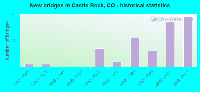
- New bridges - historical statistics
- 11920-1929
- 11930-1939
- 71960-1969
- 21970-1979
- 111980-1989
- 61990-1999
- 172000-2009
- 192010-2019
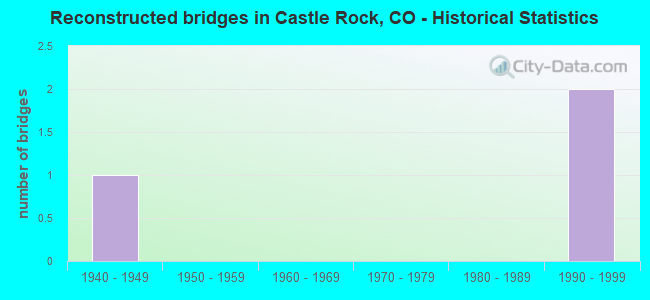
- Reconstructed bridges - Historical Statistics
- 11940-1949
- 01950-1959
- 01960-1969
- 01970-1979
- 01980-1989
- 21990-1999
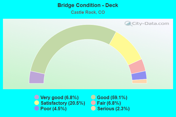
- Bridge Condition - Deck
- 6.8%Very good
- 59.1%Good
- 20.5%Satisfactory
- 6.8%Fair
- 4.5%Poor
- 2.3%Serious
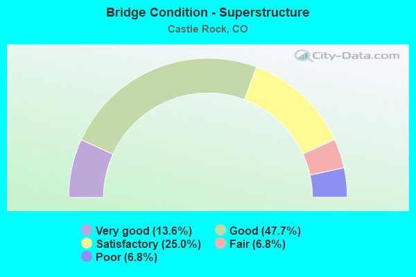
- Bridge Condition - Superstructure
- 13.6%Very good
- 47.7%Good
- 25.0%Satisfactory
- 6.8%Fair
- 6.8%Poor
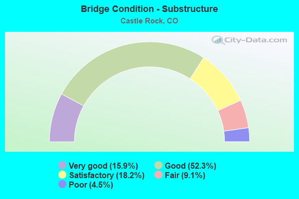
- Bridge Condition - Substructure
- 15.9%Very good
- 52.3%Good
- 18.2%Satisfactory
- 9.1%Fair
- 4.5%Poor
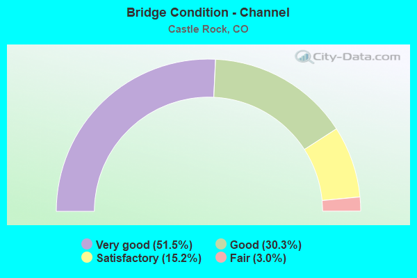
- Bridge Condition - Channel
- 51.5%Very good
- 30.3%Good
- 15.2%Satisfactory
- 3.0%Fair
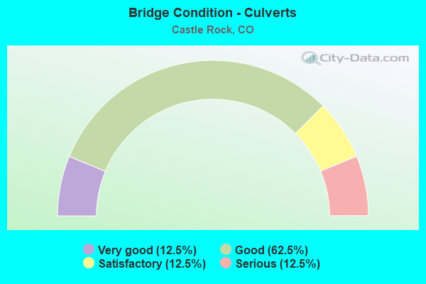
- Bridge Condition - Culverts
- 12.5%Very good
- 62.5%Good
- 12.5%Satisfactory
- 12.5%Serious
Find on map >> Show street view
Structure Number: CAS BUNAVISTA-1, Location: 0.1 MI SW OF ROCKY MNT DR (Lat: 39.407978, Lng: -104.918383), Route carried "on" structure: City street , Year Built: 1989, Status: Open, Structure Length: 0.64m (2.10ft), Average Daily Traffic: 152 (year 2021), Average Future Daily Traffic: 204 (year 2041), Features Intersected: LOCAL DRAINAGE, Facility Carried by Structure: BUENA VISTA BLVD
Minimum Vertical Clearance: 30+ m (98+ ft), Kilometerpoint: 0.069, Lanes on structure: 2, Owner: Town or Township Highway Agency, Approaching Roadway Width: 11.0m (36.1ft), Material/Design: Concrete, Design/Construction: Culvert, Number Of Spans In Main Unit: 2, Length of Maximum Span: 3.0m (9.8ft), Curb or Sidewalk Widths: Left: 1.4m (4.6ft), Right: 1.4m (4.6ft), Curb-To-Curb Width: 11.0m (36.1ft), Out-to-Out Width: 26.2m (86.0ft)
Condition: Channel: Very good, Culverts: Good, Operating Rating: 80.6 metric tons, Method Used To Determine Operating Rating: Load Factor (LF), Inventory Rating: 48.4 metric tons, Method Used To Determine Inventory Rating: Load Factor (LF), Structural Evaluation: Better than present minimum criteria, Deck Geometry: Equal to present desirable criteria, Waterway Adequacy: Equal to present desirable criteria, Approach Roadway Alignment: Equal to present desirable criteria, Designated Inspection Frequency: Every 24 months, Inspection Date: Febuary 2021
Find on map >> Show street view
Structure Number: CAS BUS-0.1, Location: JUST SOUTH OF SCOTT BLVD (Lat: 39.390186, Lng: -104.855211), Route carried "on" structure: City street , Year Built: 2002, Status: Open, Structure Length: 2.33m (7.64ft), Average Daily Traffic: 531 (year 2021), Truck Traffic: 90%, Average Future Daily Traffic: 712 (year 2041), Design Load: HS 25 or greater, Features Intersected: LOCAL DRAINAGE, Facility Carried by Structure: BUS ENTRANCE
Minimum Vertical Clearance: 30+ m (98+ ft), Kilometerpoint: 0.401, Lanes on structure: 2, Owner: Town or Township Highway Agency, Approaching Roadway Width: 11.1m (36.4ft), Skew: 9 degrees, Material/Design: Concrete continuous, Design/Construction: Slab, Number Of Spans In Main Unit: 2, Length of Maximum Span: 11.2m (36.7ft), Curb or Sidewalk Widths: Left: 1.7m (5.6ft), Right: 0.0m, Curb-To-Curb Width: 8.5m (27.9ft), Out-to-Out Width: 11.0m (36.1ft)
Condition: Deck: Satisfactory, Superstructure: Satisfactory, Substructure: Good, Channel: Very good, Operating Rating: 92.3 metric tons, Method Used To Determine Operating Rating: Load Factor (LF), Inventory Rating: 55.3 metric tons, Method Used To Determine Inventory Rating: Load Factor (LF), Structural Evaluation: Equal to present minimum criteria, Deck Geometry: High priority of corrective action, Waterway Adequacy: Equal to present desirable criteria, Approach Roadway Alignment: Equal to present desirable criteria, Designated Inspection Frequency: Every 24 months, Inspection Date: Febuary 2021, Deck Structure Type: Concrete Cast-file-Place, Wearing Surface/Protective System: Wearing Surface: Bituminous, Deck Protection: Epoxy Coated Reinforcing
Find on map >> Show street view
Structure Number: CAS CASOAK 4.5A, Location: 0.2 MI W PLEASANT VIEW DR (Lat: 39.422447, Lng: -104.789908), Route carried "on" structure: City street , Year Built: 2019, Status: Open, Structure Length: 1.98m (6.50ft), Average Daily Traffic: 2,205 (year 2021), Average Future Daily Traffic: 2,955 (year 2041), Design Load: HL 93, Features Intersected: MCMURDO GULCH, Facility Carried by Structure: CASTLE OAK DRIVE
Minimum Vertical Clearance: 30+ m (98+ ft), Kilometerpoint: 5.790, Lanes on structure: 3, Owner: Town or Township Highway Agency, Approaching Roadway Width: 20.7m (67.9ft), Skew: 2 degrees, Material/Design: Concrete, Design/Construction: Culvert, Number Of Spans In Main Unit: 5, Length of Maximum Span: 4.0m (13.1ft), Curb or Sidewalk Widths: Left: 3.7m (12.1ft), Right: 2.4m (7.9ft), Curb-To-Curb Width: 24.9m (81.7ft), Out-to-Out Width: 25.8m (84.6ft)
Condition: Channel: Very good, Culverts: Good, Operating Rating: 96.9 metric tons, Method Used To Determine Operating Rating: Load and Resistance Factor Rating (LRFR) rating reported by rating factor(RF) method using HL-93 loadings, Inventory Rating: 96.9 metric tons, Method Used To Determine Inventory Rating: Load and Resistance Factor Rating (LRFR) rating reported by rating factor(RF) method using HL-93 loadings, Structural Evaluation: Better than present minimum criteria, Deck Geometry: Superior to present desirable criteria, Waterway Adequacy: Equal to present desirable criteria, Approach Roadway Alignment: Equal to present desirable criteria, Designated Inspection Frequency: Every 24 months, Inspection Date: Febuary 2021
Find on map >> Show street view
Structure Number: CAS CASOAK-2.7, Location: 2.7 MI E FOUNDERS PKWAY (Lat: 39.405194, Lng: -104.812425), Route carried "on" structure: City street , Year Built: 1975, Status: Open, Structure Length: 1.23m (4.04ft), Average Daily Traffic: 3,289 (year 2021), Average Future Daily Traffic: 4,407 (year 2041), Features Intersected: MCMURDO GULCH, Facility Carried by Structure: CASTLE OAK DRIVE
Minimum Vertical Clearance: 30+ m (98+ ft), Kilometerpoint: 2.707, Lanes on structure: 2, Owner: Town or Township Highway Agency, Approaching Roadway Width: 9.1m (29.9ft), Material/Design: Steel, Design/Construction: Stringer/Multi-beam, Number Of Spans In Main Unit: 1, Length of Maximum Span: 11.6m (38.1ft), Curb-To-Curb Width: 9.1m (29.9ft), Out-to-Out Width: 9.1m (29.9ft)
Condition: Deck: Good, Superstructure: Fair, Substructure: Satisfactory, Channel: Good, Operating Rating: 30.3 metric tons, Method Used To Determine Operating Rating: Load Factor (LF), Inventory Rating: 18.1 metric tons, Method Used To Determine Inventory Rating: Load Factor (LF), Structural Evaluation: Somewhat better than minimum adequacy, Deck Geometry: Meets minimum limits, Waterway Adequacy: Equal to present desirable criteria, Approach Roadway Alignment: Somewhat better than minimum adequacy, Designated Inspection Frequency: Every 24 months, Inspection Date: Febuary 2021, Deck Structure Type: Corrugated Steel, Wearing Surface/Protective System: Wearing Surface: Other
Find on map >> Show street view
Structure Number: CAS CASOAK-3.3, Location: .1 MI S OF JUNIPER PLACE (Lat: 39.414350, Lng: -104.806681), Route carried "on" structure: City street , Year Built: 1975, Status: Open, Structure Length: 1.23m (4.04ft), Average Daily Traffic: 3,289 (year 2021), Average Future Daily Traffic: 4,407 (year 2041), Features Intersected: MCMURDO GULCH, Facility Carried by Structure: CASTLE OAK DRIVE
Minimum Vertical Clearance: 30+ m (98+ ft), Kilometerpoint: 3.848, Lanes on structure: 2, Owner: Town or Township Highway Agency, Approaching Roadway Width: 9.1m (29.9ft), Material/Design: Steel, Design/Construction: Stringer/Multi-beam, Number Of Spans In Main Unit: 1, Length of Maximum Span: 11.6m (38.1ft), Curb-To-Curb Width: 9.0m (29.5ft), Out-to-Out Width: 9.1m (29.9ft)
Condition: Deck: Good, Superstructure: Fair, Substructure: Satisfactory, Channel: Good, Operating Rating: 30.3 metric tons, Method Used To Determine Operating Rating: Load Factor (LF), Inventory Rating: 18.1 metric tons, Method Used To Determine Inventory Rating: Load Factor (LF), Structural Evaluation: Somewhat better than minimum adequacy, Deck Geometry: Meets minimum limits, Waterway Adequacy: Equal to present desirable criteria, Approach Roadway Alignment: Equal to present desirable criteria, Designated Inspection Frequency: Every 24 months, Inspection Date: Febuary 2021, Deck Structure Type: Corrugated Steel, Wearing Surface/Protective System: Wearing Surface: Other
Find on map >> Show street view
Structure Number: CAS CASOAK-5.6A, Location: 0.4 MI W OF HIGHWAY 83 (Lat: 39.416811, Lng: -104.769122), Route carried "on" structure: City street , Year Built: 2006, Status: Open, Structure Length: 9.31m (30.54ft), Average Daily Traffic: 3,995 (year 2021), Average Future Daily Traffic: 5,353 (year 2041), Design Load: HS 20, Features Intersected: CHERRY CREEK, Facility Carried by Structure: CASTLE OAK DRIVE
Minimum Vertical Clearance: 30+ m (98+ ft), Kilometerpoint: 7.846, Lanes on structure: 2, Owner: Town or Township Highway Agency, Approaching Roadway Width: 10.9m (35.8ft), Material/Design: Prestressed concrete continuous, Design/Construction: Stringer/Multi-beam, Number Of Spans In Main Unit: 3, Length of Maximum Span: 29.8m (97.8ft), Curb or Sidewalk Widths: Left: 3.0m (9.8ft), Right: 0.0m, Curb-To-Curb Width: 11.0m (36.1ft), Out-to-Out Width: 14.9m (48.9ft)
Condition: Deck: Good, Superstructure: Good, Substructure: Good, Channel: Fair, Operating Rating: 62.5 metric tons, Method Used To Determine Operating Rating: Load Factor (LF), Inventory Rating: 33.0 metric tons, Method Used To Determine Inventory Rating: Load Factor (LF), Structural Evaluation: Better than present minimum criteria, Deck Geometry: Somewhat better than minimum adequacy, Waterway Adequacy: Equal to present desirable criteria, Approach Roadway Alignment: Equal to present desirable criteria, Designated Inspection Frequency: Every 24 months, Inspection Date: Febuary 2021, Deck Structure Type: Concrete Precast Panels, Wearing Surface/Protective System: Wearing Surface: Bituminous, Membrane: Built-up, Deck Protection: Epoxy Coated Reinforcing
Find on map >> Show street view
Structure Number: CAS CASRKPWY-1, Location: N OF CASTLE ROCK (Lat: 39.424222, Lng: -104.875769), Route carried "on" structure: Interstate , Year Built: 2015, Status: Open, Structure Length: 3.26m (10.70ft), Average Daily Traffic: 64,883 (year 2021), Truck Traffic: 9%, Average Future Daily Traffic: 86,943 (year 2041), Design Load: HS 25 or greater, Features Intersected: N MEADOWS PARKWAY, Facility Carried by Structure: I-25 ML NBND
Minimum Vertical Clearance: 30+ m (98+ ft), Kilometerpoint: 297.663, Lanes on structure: 5, Lanes under structure: 3, Owner: Town or Township Highway Agency, Approaching Roadway Width: 19.8m (65.0ft), Skew: 3 degrees, Material/Design: Prestressed concrete, Design/Construction: Stringer/Multi-beam, Number Of Spans In Main Unit: 1, Length of Maximum Span: 31.5m (103.3ft), Curb-To-Curb Width: 27.0m (88.6ft), Out-to-Out Width: 27.9m (91.5ft)
Condition: Deck: Very good, Superstructure: Good, Substructure: Good, Operating Rating: 68.9 metric tons, Method Used To Determine Operating Rating: Load and Resistance Factor (LRFR), Inventory Rating: 35.9 metric tons, Method Used To Determine Inventory Rating: Load and Resistance Factor (LRFR), Structural Evaluation: Better than present minimum criteria, Deck Geometry: Superior to present desirable criteria, Underclear: Somewhat better than minimum adequacy, Approach Roadway Alignment: Equal to present desirable criteria, Designated Inspection Frequency: Every 24 months, Inspection Date: March 2021, Deck Structure Type: Concrete Precast Panels, Wearing Surface/Protective System: Wearing Surface: Epoxy Overlay, Deck Protection: Epoxy Coated Reinforcing
Find on map >> Show street view
Structure Number: CAS CASRKPWY-2, Location: N OF CASTLE ROCK (Lat: 39.429747, Lng: -104.876008), Route carried "on" structure: Interstate , Year Built: 2015, Status: Open, Structure Length: 3.26m (10.70ft), Average Daily Traffic: 64,883 (year 2021), Truck Traffic: 9%, Average Future Daily Traffic: 86,943 (year 2041), Design Load: HS 25 or greater, Features Intersected: N MEADOWS PARKWAY, Facility Carried by Structure: I-25 ML SBND
Minimum Vertical Clearance: 30+ m (98+ ft), Kilometerpoint: 297.650, Lanes on structure: 4, Lanes under structure: 3, Base Highway Network: Yes, Owner: Town or Township Highway Agency, Approaching Roadway Width: 19.8m (65.0ft), Skew: 3 degrees, Material/Design: Prestressed concrete, Design/Construction: Stringer/Multi-beam, Number Of Spans In Main Unit: 1, Length of Maximum Span: 31.5m (103.3ft), Curb-To-Curb Width: 20.3m (66.6ft), Out-to-Out Width: 21.2m (69.6ft)
Condition: Deck: Very good, Superstructure: Good, Substructure: Good, Operating Rating: 68.9 metric tons, Method Used To Determine Operating Rating: Load and Resistance Factor (LRFR), Inventory Rating: 35.9 metric tons, Method Used To Determine Inventory Rating: Load and Resistance Factor (LRFR), Structural Evaluation: Better than present minimum criteria, Deck Geometry: Equal to present minimum criteria, Underclear: Meets minimum limits, Approach Roadway Alignment: Equal to present desirable criteria, Designated Inspection Frequency: Every 24 months, Inspection Date: March 2021, Deck Structure Type: Concrete Cast-file-Place, Wearing Surface/Protective System: Wearing Surface: Monolithic Concrete, Deck Protection: Epoxy Coated Reinforcing
Find on map >> Show street view
Structure Number: CAS CASRKPWY-3, Location: NBND ON RAMP A (Lat: 39.420211, Lng: -104.888297), Route carried "on" structure: Ramp US , Year Built: 2014, Status: Open, Structure Length: 11.69m (38.35ft), Average Daily Traffic: 4,317 (year 2022), Truck Traffic: 1%, Average Future Daily Traffic: 5,785 (year 2042), Design Load: HL 93, Features Intersected: TERRAIN, Facility Carried by Structure: US 85 NB ON RAMP
Minimum Vertical Clearance: 30.18m (99.02ft), Kilometerpoint: 1.394, Lanes on structure: 2, Base Highway Network: Yes, Owner: Town or Township Highway Agency, Approaching Roadway Width: 16.0m (52.5ft), Material/Design: Prestressed concrete continuous, Design/Construction: Stringer/Multi-beam, Number Of Spans In Main Unit: 4, Length of Maximum Span: 32.0m (105.0ft), Curb-To-Curb Width: 11.6m (38.1ft), Out-to-Out Width: 12.5m (41.0ft)
Condition: Deck: Good, Superstructure: Good, Substructure: Very good, Operating Rating: 43.1 metric tons, Method Used To Determine Operating Rating: Load and Resistance Factor Rating (LRFR) rating reported by rating factor(RF) method using HL-93 loadings, Inventory Rating: 33.0 metric tons, Method Used To Determine Inventory Rating: Load and Resistance Factor Rating (LRFR) rating reported by rating factor(RF) method using HL-93 loadings, Structural Evaluation: Better than present minimum criteria, Deck Geometry: Superior to present desirable criteria, Approach Roadway Alignment: Equal to present desirable criteria, Designated Inspection Frequency: Every 24 months, Inspection Date: April 2021, Deck Structure Type: Concrete Cast-file-Place, Wearing Surface/Protective System: Wearing Surface: Monolithic Concrete, Deck Protection: Epoxy Coated Reinforcing
Find on map >> Show street view
Structure Number: CAS CASRKPWY-4, Location: US85 NBND OFFRAMP (Lat: 39.420769, Lng: -104.889142), Route carried "on" structure: Ramp US , Year Built: 2014, Status: Open, Structure Length: 7.51m (24.64ft), Average Daily Traffic: 1,877 (year 2022), Truck Traffic: 1%, Average Future Daily Traffic: 2,515 (year 2042), Design Load: HL 93, Features Intersected: TERRAIN, Facility Carried by Structure: US 85 OFF RAMP
Minimum Vertical Clearance: 30+ m (98+ ft), Kilometerpoint: 1.394, Lanes on structure: 2, Base Highway Network: Yes, Owner: Town or Township Highway Agency, Approaching Roadway Width: 12.4m (40.7ft), Material/Design: Prestressed concrete continuous, Design/Construction: Stringer/Multi-beam, Number Of Spans In Main Unit: 2, Length of Maximum Span: 37.8m (124.0ft), Curb-To-Curb Width: 12.4m (40.7ft), Out-to-Out Width: 13.3m (43.6ft)
Condition: Deck: Good, Superstructure: Very good, Substructure: Very good, Operating Rating: 61.6 metric tons, Method Used To Determine Operating Rating: Load and Resistance Factor Rating (LRFR) rating reported by rating factor(RF) method using HL-93 loadings, Inventory Rating: 42.1 metric tons, Method Used To Determine Inventory Rating: Load and Resistance Factor Rating (LRFR) rating reported by rating factor(RF) method using HL-93 loadings, Structural Evaluation: Equal to present desirable criteria, Deck Geometry: Superior to present desirable criteria, Approach Roadway Alignment: Equal to present desirable criteria, Designated Inspection Frequency: Every 24 months, Inspection Date: April 2021, Deck Structure Type: Concrete Cast-file-Place, Wearing Surface/Protective System: Wearing Surface: Monolithic Concrete, Deck Protection: Epoxy Coated Reinforcing
Find on map >> Show street view
Structure Number: CAS CASRKPWY-5, Location: SBND ON RAMP C (Lat: 39.419722, Lng: -104.887500), Route carried "on" structure: Ramp US , Year Built: 2014, Status: Open, Structure Length: 7.51m (24.64ft), Average Daily Traffic: 1,862 (year 2022), Truck Traffic: 3%, Average Future Daily Traffic: 2,495 (year 2042), Design Load: HL 93, Features Intersected: TERRAIN, Facility Carried by Structure: US 85 SB ON RAMP
Minimum Vertical Clearance: 30+ m (98+ ft), Kilometerpoint: 3.727, Lanes on structure: 2, Base Highway Network: Yes, Owner: Town or Township Highway Agency, Approaching Roadway Width: 7.3m (24.0ft), Material/Design: Prestressed concrete continuous, Design/Construction: Stringer/Multi-beam, Number Of Spans In Main Unit: 2, Length of Maximum Span: 38.6m (126.6ft), Curb-To-Curb Width: 8.8m (28.9ft), Out-to-Out Width: 9.8m (32.2ft)
Condition: Deck: Good, Superstructure: Very good, Substructure: Very good, Operating Rating: 64.8 metric tons, Method Used To Determine Operating Rating: Load and Resistance Factor Rating (LRFR) rating reported by rating factor(RF) method using HL-93 loadings, Inventory Rating: 35.6 metric tons, Method Used To Determine Inventory Rating: Load and Resistance Factor Rating (LRFR) rating reported by rating factor(RF) method using HL-93 loadings, Structural Evaluation: Equal to present desirable criteria, Deck Geometry: Meets minimum limits, Approach Roadway Alignment: Equal to present desirable criteria, Designated Inspection Frequency: Every 24 months, Inspection Date: March 2021, Deck Structure Type: Concrete Precast Panels, Wearing Surface/Protective System: Wearing Surface: Monolithic Concrete, Membrane: Built-up, Deck Protection: Epoxy Coated Reinforcing
Find on map >> Show street view
Structure Number: CAS CASRKPWY-6, Location: SBND OFF RAMP D (Lat: 39.422028, Lng: -104.892944), Route carried "on" structure: Ramp US , Year Built: 2014, Status: Open, Structure Length: 21.87m (71.75ft), Average Daily Traffic: 2,540 (year 2022), Truck Traffic: 3%, Average Future Daily Traffic: 3,403 (year 2042), Design Load: HL 93, Features Intersected: TERRAIN, Facility Carried by Structure: US 85 SB OFF RAMP
Minimum Vertical Clearance: 30+ m (98+ ft), Kilometerpoint: 3.727, Lanes on structure: 2, Base Highway Network: Yes, Owner: Town or Township Highway Agency, Approaching Roadway Width: 7.3m (24.0ft), Material/Design: Prestressed concrete continuous, Design/Construction: Stringer/Multi-beam, Number Of Spans In Main Unit: 7, Length of Maximum Span: 34.8m (114.2ft), Curb-To-Curb Width: 8.8m (28.9ft), Out-to-Out Width: 9.8m (32.2ft)
Condition: Deck: Good, Superstructure: Very good, Substructure: Very good, Operating Rating: 65.1 metric tons, Method Used To Determine Operating Rating: Load and Resistance Factor Rating (LRFR) rating reported by rating factor(RF) method using HL-93 loadings, Inventory Rating: 34.7 metric tons, Method Used To Determine Inventory Rating: Load and Resistance Factor Rating (LRFR) rating reported by rating factor(RF) method using HL-93 loadings, Structural Evaluation: Equal to present desirable criteria, Deck Geometry: Meets minimum limits, Approach Roadway Alignment: Equal to present desirable criteria, Designated Inspection Frequency: Every 24 months, Inspection Date: March 2021, Deck Structure Type: Concrete Precast Panels, Wearing Surface/Protective System: Wearing Surface: Monolithic Concrete
Find on map >> Show street view
Structure Number: CAS CASRKPWY-7, Location: N Meadows Pkwy (Lat: 39.421075, Lng: -104.887958), Route carried "on" structure: Ramp US , Year Built: 2014, Status: Open, Structure Length: 10.05m (32.97ft), Average Daily Traffic: 14,973 (year 2022), Truck Traffic: 3%, Average Future Daily Traffic: 20,063 (year 2042), Design Load: HL 93, Features Intersected: US 85 and UPRR, Facility Carried by Structure: Castle Rock Pkwy
Minimum Vertical Clearance: 30+ m (98+ ft), Kilometerpoint: 3.759, Lanes on structure: 3, Lanes under structure: 2, Base Highway Network: Yes, Owner: Town or Township Highway Agency, Approaching Roadway Width: 31.4m (103.0ft), Material/Design: Prestressed concrete continuous, Design/Construction: Stringer/Multi-beam, Number Of Spans In Main Unit: 3, Length of Maximum Span: 41.8m (137.1ft), Curb or Sidewalk Widths: Left: 3.2m (10.5ft), Right: 3.2m (10.5ft), Curb-To-Curb Width: 27.5m (90.2ft), Out-to-Out Width: 38.7m (127.0ft)
Condition: Deck: Very good, Superstructure: Good, Substructure: Very good, Operating Rating: 45.4 metric tons, Method Used To Determine Operating Rating: Load and Resistance Factor Rating (LRFR) rating reported by rating factor(RF) method using HL-93 loadings, Inventory Rating: 32.4 metric tons, Method Used To Determine Inventory Rating: Load and Resistance Factor Rating (LRFR) rating reported by rating factor(RF) method using HL-93 loadings, Structural Evaluation: Better than present minimum criteria, Deck Geometry: Superior to present desirable criteria, Approach Roadway Alignment: Equal to present desirable criteria, Designated Inspection Frequency: Every 24 months, Inspection Date: March 2021, Deck Structure Type: Concrete Precast Panels, Wearing Surface/Protective System: Wearing Surface: Integral Concrete, Membrane: Built-up, Deck Protection: Epoxy Coated Reinforcing
Find on map >> Show street view
Structure Number: CAS FIFTH-I25, Location: 0.1 MI W OF WILCOX (Lat: 39.374758, Lng: -104.864711), Route carried "on" structure: City street , Year Built: 2001, Status: Open, Structure Length: 17.15m (56.27ft), Average Daily Traffic: 6,973 (year 2021), Truck Traffic: 2%, Average Future Daily Traffic: 9,344 (year 2041), Design Load: HS 25 or greater, Features Intersected: I25 ML AND E. PLUM CK, Facility Carried by Structure: 5TH ST.
Minimum Vertical Clearance: 30+ m (98+ ft), Kilometerpoint: 0.024, Lanes on structure: 2, Lanes under structure: 8, Owner: Town or Township Highway Agency, Approaching Roadway Width: 9.1m (29.9ft), Material/Design: Steel continuous, Design/Construction: Stringer/Multi-beam, Number Of Spans In Main Unit: 3, Length of Maximum Span: 65.9m (216.2ft), Curb or Sidewalk Widths: Left: 0.0m, Right: 2.4m (7.9ft), Curb-To-Curb Width: 9.1m (29.9ft), Out-to-Out Width: 12.5m (41.0ft)
Condition: Deck: Good, Superstructure: Good, Substructure: Good, Operating Rating: 60.2 metric tons, Method Used To Determine Operating Rating: Load Factor (LF), Inventory Rating: 36.1 metric tons, Method Used To Determine Inventory Rating: Load Factor (LF), Structural Evaluation: Better than present minimum criteria, Deck Geometry: Meets minimum limits, Underclear: Superior to present desirable criteria, Waterway Adequacy: Superior to present desirable criteria, Approach Roadway Alignment: Equal to present desirable criteria, Designated Inspection Frequency: Every 24 months, Inspection Date: Febuary 2021, Deck Structure Type: Concrete Precast Panels, Wearing Surface/Protective System: Wearing Surface: Bituminous, Membrane: Built-up, Deck Protection: Epoxy Coated Reinforcing
Find on map >> Show street view
Structure Number: CAS FRONT-RR, Location: N OF 6TH STREET (Lat: 39.376194, Lng: -104.858483), Route carried "on" structure: City street , Year Built: 2004, Status: Open, Structure Length: 22.93m (75.23ft), Average Daily Traffic: 12,441 (year 2021), Truck Traffic: 5%, Average Future Daily Traffic: 16,671 (year 2041), Design Load: HS 20, Features Intersected: RAILROAD / 7TH ST, Facility Carried by Structure: FRONT ST
Minimum Vertical Clearance: 30+ m (98+ ft), Kilometerpoint: 2.549, Lanes on structure: 2, Lanes under structure: 2, Owner: Town or Township Highway Agency, Approaching Roadway Width: 12.3m (40.4ft), Skew: 9 degrees, Material/Design: Prestressed concrete continuous, Design/Construction: Stringer/Multi-beam, Number Of Spans In Main Unit: 5, Number Of Approach Spans: 1, Length of Maximum Span: 42.6m (139.8ft), Curb or Sidewalk Widths: Left: 0.0m, Right: 2.6m (8.5ft), Curb-To-Curb Width: 12.2m (40.0ft), Out-to-Out Width: 15.7m (51.5ft)
Condition: Deck: Good, Superstructure: Good, Substructure: Good, Operating Rating: 50.4 metric tons, Method Used To Determine Operating Rating: Load Factor (LF), Inventory Rating: 30.2 metric tons, Method Used To Determine Inventory Rating: Load Factor (LF), Structural Evaluation: Better than present minimum criteria, Deck Geometry: Somewhat better than minimum adequacy, Underclear: Meets minimum limits, Approach Roadway Alignment: Equal to present desirable criteria, Designated Inspection Frequency: Every 24 months, Inspection Date: Febuary 2021, Deck Structure Type: Concrete Cast-file-Place, Wearing Surface/Protective System: Wearing Surface: Bituminous, Membrane: Built-up, Deck Protection: Epoxy Coated Reinforcing
Find on map >> Show street view
Structure Number: CAS GILBERT-.2, Location: 0.1 MILE S. OF SOUTH ST. (Lat: 39.368356, Lng: -104.852500), Route carried "on" structure: City street , Year Built: 1985, Status: Open, Structure Length: 1.31m (4.30ft), Average Daily Traffic: 7,806 (year 2021), Truck Traffic: 4%, Average Future Daily Traffic: 10,460 (year 2041), Features Intersected: SELLARS GULCH TRIBUTARY, Facility Carried by Structure: SOUTH GILBERT ST
Minimum Vertical Clearance: 30+ m (98+ ft), Kilometerpoint: 1.469, Lanes on structure: 2, Owner: Town or Township Highway Agency, Approaching Roadway Width: 12.5m (41.0ft), Material/Design: Prestressed concrete, Design/Construction: Tee Beam, Number Of Spans In Main Unit: 1, Length of Maximum Span: 12.2m (40.0ft), Curb or Sidewalk Widths: Left: 0.6m (2.0ft), Right: 3.0m (9.8ft), Curb-To-Curb Width: 12.8m (42.0ft), Out-to-Out Width: 17.1m (56.1ft)
Condition: Deck: Good, Superstructure: Satisfactory, Substructure: Good, Channel: Very good, Operating Rating: 36.3 metric tons, Method Used To Determine Operating Rating: Field evaluation and documented engineering judgment, Inventory Rating: 32.7 metric tons, Method Used To Determine Inventory Rating: Field evaluation and documented engineering judgment, Structural Evaluation: Equal to present minimum criteria, Deck Geometry: Somewhat better than minimum adequacy, Waterway Adequacy: Equal to present desirable criteria, Approach Roadway Alignment: Equal to present desirable criteria, Designated Inspection Frequency: Every 24 months, Inspection Date: Febuary 2021, Deck Structure Type: Concrete Cast-file-Place, Wearing Surface/Protective System: Wearing Surface: Bituminous
Find on map >> Show street view
Structure Number: CAS MEADOWS-1, Location: JUST WEST OF HIGHWAY 85 (Lat: 39.407133, Lng: -104.876658), Route carried "on" structure: City street , Year Built: 1987, Status: Open, Structure Length: 19.96m (65.49ft), Average Daily Traffic: 13,927 (year 2021), Truck Traffic: 4%, Average Future Daily Traffic: 18,662 (year 2041), Design Load: HS 20, Features Intersected: EAST PLUM CREEK AND RR, Facility Carried by Structure: EB MEADOWS PRKY
Minimum Vertical Clearance: 30+ m (98+ ft), Kilometerpoint: 0.261, Lanes on structure: 2, Owner: Town or Township Highway Agency, Approaching Roadway Width: 8.2m (26.9ft), Material/Design: Prestressed concrete continuous, Design/Construction: Stringer/Multi-beam, Number Of Spans In Main Unit: 6, Length of Maximum Span: 39.3m (128.9ft), Curb or Sidewalk Widths: Left: 0.0m, Right: 2.4m (7.9ft), Curb-To-Curb Width: 8.2m (26.9ft), Out-to-Out Width: 11.3m (37.1ft)
Condition: Deck: Good, Superstructure: Good, Substructure: Good, Channel: Very good, Operating Rating: 36.2 metric tons, Method Used To Determine Operating Rating: Load Factor (LF), Inventory Rating: 21.8 metric tons, Method Used To Determine Inventory Rating: Load Factor (LF), Structural Evaluation: Somewhat better than minimum adequacy, Deck Geometry: High priority of corrective action, Underclear: Superior to present desirable criteria, Waterway Adequacy: Superior to present desirable criteria, Approach Roadway Alignment: Equal to present desirable criteria, Length Of Structure Improvement: 19.96m (65.49ft), Designated Inspection Frequency: Every 24 months, Inspection Date: Febuary 2021, Deck Structure Type: Concrete Cast-file-Place, Wearing Surface/Protective System: Wearing Surface: Bituminous, Membrane: Built-up, Deck Protection: Epoxy Coated Reinforcing
Find on map >> Show street view
Structure Number: CAS MEADOWS-2, Location: JUST WEST OF HIGHWAY 85 (Lat: 39.407281, Lng: -104.876917), Route carried "on" structure: City street , Year Built: 1987, Status: Open, Structure Length: 19.96m (65.49ft), Average Daily Traffic: 13,297 (year 2021), Truck Traffic: 4%, Average Future Daily Traffic: 17,818 (year 2041), Design Load: HS 20, Features Intersected: EAST PLUM CREEK AND RR, Facility Carried by Structure: WB MEADOWS PRKY
Minimum Vertical Clearance: 30+ m (98+ ft), Kilometerpoint: 0.259, Lanes on structure: 2, Owner: Town or Township Highway Agency, Approaching Roadway Width: 8.2m (26.9ft), Material/Design: Prestressed concrete continuous, Design/Construction: Stringer/Multi-beam, Number Of Spans In Main Unit: 6, Length of Maximum Span: 39.3m (128.9ft), Curb or Sidewalk Widths: Left: 2.4m (7.9ft), Right: 0.0m, Curb-To-Curb Width: 8.2m (26.9ft), Out-to-Out Width: 11.3m (37.1ft)
Condition: Deck: Good, Superstructure: Good, Substructure: Good, Channel: Very good, Operating Rating: 36.2 metric tons, Method Used To Determine Operating Rating: Load Factor (LF), Inventory Rating: 21.8 metric tons, Method Used To Determine Inventory Rating: Load Factor (LF), Structural Evaluation: Somewhat better than minimum adequacy, Deck Geometry: High priority of corrective action, Underclear: Superior to present desirable criteria, Waterway Adequacy: Superior to present desirable criteria, Approach Roadway Alignment: Equal to present desirable criteria, Length Of Structure Improvement: 19.96m (65.49ft), Designated Inspection Frequency: Every 24 months, Inspection Date: Febuary 2021, Deck Structure Type: Concrete Cast-file-Place, Wearing Surface/Protective System: Wearing Surface: Bituminous, Membrane: Built-up
Find on map >> Show street view
Structure Number: CAS MEADOWS-3, Location: MEADOWS BLVD N OF MEADOWS (Lat: 39.407714, Lng: -104.889106), Route carried "on" structure: City street , Year Built: 1986, Status: Open, Structure Length: 0.76m (2.49ft), Average Daily Traffic: 6,672 (year 2022), Truck Traffic: 4%, Average Future Daily Traffic: 8,941 (year 2042), Design Load: HS 20, Features Intersected: EAST PLUM CREEK TRIBUTAR, Facility Carried by Structure: MEADOWS BLVD
Minimum Vertical Clearance: 30+ m (98+ ft), Kilometerpoint: 2.624, Lanes on structure: 5, Owner: Town or Township Highway Agency, Approaching Roadway Width: 16.5m (54.1ft), Skew: 23 degrees, Material/Design: Concrete, Design/Construction: Culvert, Number Of Spans In Main Unit: 1, Length of Maximum Span: 7.6m (24.9ft), Curb or Sidewalk Widths: Left: 2.6m (8.5ft), Right: 2.7m (8.9ft), Curb-To-Curb Width: 29.3m (96.1ft), Out-to-Out Width: 30.8m (101.0ft)
Condition: Channel: Satisfactory, Culverts: Good, Inventory Rating: 67.0 metric tons, Method Used To Determine Inventory Rating: Load Factor (LF), Structural Evaluation: Better than present minimum criteria, Deck Geometry: Superior to present desirable criteria, Waterway Adequacy: Equal to present desirable criteria, Approach Roadway Alignment: Equal to present desirable criteria, Designated Inspection Frequency: Every 48 months, Inspection Date: Febuary 2019
Find on map >> Show street view
Structure Number: CAS MEADOWS-4, Location: 1.3 MI W OF MEADOWS PKWY (Lat: 39.400275, Lng: -104.906283), Route carried "on" structure: City street , Year Built: 1987, Status: Open, Structure Length: 0.65m (2.13ft), Average Daily Traffic: 4,911 (year 2022), Truck Traffic: 4%, Average Future Daily Traffic: 6,581 (year 2042), Design Load: HS 20, Features Intersected: EAST PLUM CREEK TRIBUTAR, Facility Carried by Structure: MEADOWS BLVD
Minimum Vertical Clearance: 30+ m (98+ ft), Kilometerpoint: 5.074, Lanes on structure: 4, Owner: Town or Township Highway Agency, Approaching Roadway Width: 16.5m (54.1ft), Skew: 21 degrees, Material/Design: Concrete, Design/Construction: Culvert, Number Of Spans In Main Unit: 1, Length of Maximum Span: 6.5m (21.3ft), Curb or Sidewalk Widths: Left: 1.8m (5.9ft), Right: 0.0m, Curb-To-Curb Width: 29.0m (95.1ft), Out-to-Out Width: 30.5m (100.1ft)
Condition: Channel: Very good, Culverts: Very good, Operating Rating: 96.8 metric tons, Method Used To Determine Operating Rating: Load Factor (LF), Inventory Rating: 58.1 metric tons, Method Used To Determine Inventory Rating: Load Factor (LF), Structural Evaluation: Equal to present desirable criteria, Deck Geometry: Superior to present desirable criteria, Waterway Adequacy: Equal to present desirable criteria, Approach Roadway Alignment: Equal to present desirable criteria, Designated Inspection Frequency: Every 48 months, Inspection Date: Febuary 2019
Find on map >> Show street view
Structure Number: CAS MEADOWS-5, Location: 0.2 MI W OF COACHLINE ROA (Lat: 39.390939, Lng: -104.901417), Route carried "on" structure: City street , Year Built: 1987, Status: Open, Structure Length: 0.61m (2.00ft), Average Daily Traffic: 8,602 (year 2022), Truck Traffic: 4%, Average Future Daily Traffic: 11,527 (year 2042), Design Load: HS 20, Features Intersected: EAST PLUM CREEK TRIBUTAR, Facility Carried by Structure: MEADOWS BLVD
Minimum Vertical Clearance: 30+ m (98+ ft), Kilometerpoint: 6.259, Lanes on structure: 4, Owner: Town or Township Highway Agency, Approaching Roadway Width: 16.5m (54.1ft), Skew: 20 degrees, Material/Design: Concrete, Design/Construction: Culvert, Number Of Spans In Main Unit: 1, Length of Maximum Span: 6.1m (20.0ft), Curb or Sidewalk Widths: Left: 2.4m (7.9ft), Right: 1.5m (4.9ft), Curb-To-Curb Width: 28.8m (94.5ft), Out-to-Out Width: 30.3m (99.4ft)
Condition: Channel: Very good, Culverts: Good, Operating Rating: 90.5 metric tons, Method Used To Determine Operating Rating: Load Factor (LF), Inventory Rating: 54.2 metric tons, Method Used To Determine Inventory Rating: Load Factor (LF), Structural Evaluation: Better than present minimum criteria, Deck Geometry: Superior to present desirable criteria, Waterway Adequacy: Equal to present desirable criteria, Approach Roadway Alignment: Equal to present desirable criteria, Designated Inspection Frequency: Every 48 months, Inspection Date: Febuary 2019
Find on map >> Show street view
Structure Number: CAS OLD85-I25, Location: JUST W OF FRONT ST. (Lat: 39.400250, Lng: -104.862206), Route carried "on" structure: City street , Year Built: 2002, Status: Open, Structure Length: 7.88m (25.85ft), Average Daily Traffic: 9,179 (year 2022), Truck Traffic: 10%, Average Future Daily Traffic: 12,300 (year 2042), Design Load: HS 25 or greater, Features Intersected: I25 ML, Facility Carried by Structure: SANTE FE DR.
Minimum Vertical Clearance: 30+ m (98+ ft), Kilometerpoint: 1.570, Lanes on structure: 4, Lanes under structure: 8, Owner: Town or Township Highway Agency, Approaching Roadway Width: 20.7m (67.9ft), Skew: 1 degrees, Material/Design: Prestressed concrete continuous, Design/Construction: Stringer/Multi-beam, Number Of Spans In Main Unit: 2, Length of Maximum Span: 38.4m (126.0ft), Curb or Sidewalk Widths: Left: 2.6m (8.5ft), Right: 0.0m, Curb-To-Curb Width: 20.7m (67.9ft), Out-to-Out Width: 24.2m (79.4ft)
Condition: Deck: Good, Superstructure: Good, Substructure: Good, Operating Rating: 58.5 metric tons, Method Used To Determine Operating Rating: Load Factor (LF), Inventory Rating: 16.1 metric tons, Method Used To Determine Inventory Rating: Load Factor (LF), Structural Evaluation: High priority of corrective action, Deck Geometry: Superior to present desirable criteria, Underclear: Superior to present desirable criteria, Approach Roadway Alignment: Equal to present desirable criteria, Designated Inspection Frequency: Every 24 months, Inspection Date: Febuary 2021, Deck Structure Type: Concrete Cast-file-Place, Wearing Surface/Protective System: Wearing Surface: Bituminous, Membrane: Preformed Fabric, Deck Protection: Epoxy Coated Reinforcing
Find on map >> Show street view
Structure Number: CAS OMAN-0.3, Location: 0.1 MI S OF SOUTH STREET (Lat: 39.368858, Lng: -104.849589), Route carried "on" structure: City street , Year Built: 1992, Status: Open, Structure Length: 2.13m (6.99ft), Average Daily Traffic: 1,106 (year 2021), Truck Traffic: 2%, Average Future Daily Traffic: 1,482 (year 2041), Design Load: HS 20, Features Intersected: SELLERS GULCH TRIBUTARY, Facility Carried by Structure: OMAN ROAD
Minimum Vertical Clearance: 30+ m (98+ ft), Kilometerpoint: 0.063, Lanes on structure: 2, Owner: Town or Township Highway Agency, Approaching Roadway Width: 12.2m (40.0ft), Material/Design: Prestressed concrete, Design/Construction: Box Beam or Girders - Single/Spread, Number Of Spans In Main Unit: 1, Length of Maximum Span: 19.8m (65.0ft), Curb or Sidewalk Widths: Left: 2.4m (7.9ft), Right: 1.5m (4.9ft), Curb-To-Curb Width: 12.2m (40.0ft), Out-to-Out Width: 16.6m (54.5ft)
Condition: Deck: Good, Superstructure: Good, Substructure: Good, Channel: Very good, Operating Rating: 63.0 metric tons, Method Used To Determine Operating Rating: Load Factor (LF), Inventory Rating: 35.4 metric tons, Method Used To Determine Inventory Rating: Load Factor (LF), Structural Evaluation: Better than present minimum criteria, Deck Geometry: Better than present minimum criteria, Waterway Adequacy: Equal to present desirable criteria, Approach Roadway Alignment: Equal to present desirable criteria, Designated Inspection Frequency: Every 48 months, Inspection Date: Febuary 2019, Deck Structure Type: Concrete Cast-file-Place, Wearing Surface/Protective System: Wearing Surface: Bituminous, Membrane: Built-up, Deck Protection: Epoxy Coated Reinforcing
Find on map >> Show street view
Structure Number: CAS PERRY-0.65, Location: 0.1 MI S OF SECOND STREET (Lat: 39.369942, Lng: -104.858578), Route carried "on" structure: City street , Year Built: 1998, Status: Open, Structure Length: 3.74m (12.27ft), Average Daily Traffic: 8,618 (year 2021), Truck Traffic: 9%, Average Future Daily Traffic: 11,548 (year 2041), Design Load: HS 25 or greater, Features Intersected: SELLARS GULCH, Facility Carried by Structure: PERRY STREET
Minimum Vertical Clearance: 30+ m (98+ ft), Kilometerpoint: 1.856, Lanes on structure: 2, Owner: Town or Township Highway Agency, Approaching Roadway Width: 11.0m (36.1ft), Skew: 4 degrees, Material/Design: Prestressed concrete, Design/Construction: Stringer/Multi-beam, Number Of Spans In Main Unit: 1, Length of Maximum Span: 36.1m (118.4ft), Curb or Sidewalk Widths: Left: 2.8m (9.2ft), Right: 2.8m (9.2ft), Curb-To-Curb Width: 12.3m (40.4ft), Out-to-Out Width: 19.0m (62.3ft)
Condition: Deck: Satisfactory, Superstructure: Good, Substructure: Good, Channel: Very good, Operating Rating: 71.0 metric tons, Method Used To Determine Operating Rating: Load Factor (LF), Inventory Rating: 42.5 metric tons, Method Used To Determine Inventory Rating: Load Factor (LF), Structural Evaluation: Better than present minimum criteria, Deck Geometry: Somewhat better than minimum adequacy, Waterway Adequacy: Equal to present desirable criteria, Approach Roadway Alignment: Equal to present desirable criteria, Designated Inspection Frequency: Every 24 months, Inspection Date: Febuary 2021, Deck Structure Type: Concrete Precast Panels, Wearing Surface/Protective System: Wearing Surface: Bituminous, Deck Protection: Epoxy Coated Reinforcing
Find on map >> Show street view
Structure Number: CAS PLMCKPW-.1, Location: .1 MI W OF LAKE GULCH RD (Lat: 39.356989, Lng: -104.843550), Route carried "on" structure: City street , Year Built: 1987, Status: Open, Structure Length: 1.97m (6.46ft), Average Daily Traffic: 14,950 (year 2021), Truck Traffic: 6%, Average Future Daily Traffic: 20,032 (year 2041), Design Load: HS 20+Mod, Features Intersected: SELLARS GULCH, Facility Carried by Structure: PLUM CREEK PKWY
Minimum Vertical Clearance: 30+ m (98+ ft), Kilometerpoint: 4.450, Lanes on structure: 4, Owner: Town or Township Highway Agency, Approaching Roadway Width: 18.3m (60.0ft), Skew: 30 degrees, Material/Design: Steel, Design/Construction: Culvert, Number Of Spans In Main Unit: 6, Length of Maximum Span: 3.9m (12.8ft), Curb or Sidewalk Widths: Left: 3.0m (9.8ft), Right: 2.4m (7.9ft), Out-to-Out Width: 52.4m (171.9ft)
Condition: Channel: Good, Culverts: Serious, Structural Evaluation: High priority of corrective action, Waterway Adequacy: Equal to present desirable criteria, Approach Roadway Alignment: Equal to present desirable criteria, Designated Inspection Frequency: Every 12 months, Inspection Date: Febuary 2021
Find on map >> Show street view
Structure Number: CAS PLMCKPW-.3, Location: 0.3 MI EAST OF WILCOX ST (Lat: 39.363828, Lng: -104.859217), Route carried "on" structure: City street , Year Built: 1983, Year Reconstructed: 2002, Status: Open, Structure Length: 4.47m (14.67ft), Average Daily Traffic: 22,093 (year 2021), Truck Traffic: 9%, Average Future Daily Traffic: 29,605 (year 2041), Design Load: HS 20, Features Intersected: RAILROAD, Facility Carried by Structure: PLUM CREEK PKWY
Minimum Vertical Clearance: 30+ m (98+ ft), Kilometerpoint: 2.879, Lanes on structure: 4, Owner: Town or Township Highway Agency, Approaching Roadway Width: 15.1m (49.5ft), Skew: 1 degrees, Material/Design: Prestressed concrete, Design/Construction: Tee Beam, Number Of Spans In Main Unit: 3, Length of Maximum Span: 13.4m (44.0ft), Curb or Sidewalk Widths: Left: 1.7m (5.6ft), Right: 1.5m (4.9ft), Curb-To-Curb Width: 14.5m (47.6ft), Out-to-Out Width: 18.7m (61.4ft)
Condition: Deck: Fair, Superstructure: Fair, Substructure: Satisfactory, Operating Rating: 69.6 metric tons, Method Used To Determine Operating Rating: Load Factor (LF), Inventory Rating: 37.8 metric tons, Method Used To Determine Inventory Rating: Load Factor (LF), Structural Evaluation: Somewhat better than minimum adequacy, Deck Geometry: High priority of replacement, Underclear: Equal to present minimum criteria, Approach Roadway Alignment: Equal to present desirable criteria, Designated Inspection Frequency: Every 24 months, Inspection Date: Febuary 2021, Deck Structure Type: Concrete Cast-file-Place, Wearing Surface/Protective System: Wearing Surface: Bituminous
Find on map >> Show street view
Structure Number: CAS PLMCKPW-.7, Location: 0.6 MI E OF LAKE GULCH RD (Lat: 39.361167, Lng: -104.830717), Route carried "on" structure: City street , Year Built: 2009, Status: Open, Structure Length: 0.70m (2.30ft), Average Daily Traffic: 5,195 (year 2021), Truck Traffic: 9%, Average Future Daily Traffic: 6,961 (year 2041), Features Intersected: WILDLIFE CROSSING, Facility Carried by Structure: PLUM CREEK PARKWAY
Minimum Vertical Clearance: 30+ m (98+ ft), Kilometerpoint: 5.720, Lanes on structure: 2, Owner: Town or Township Highway Agency, Approaching Roadway Width: 8.6m (28.2ft), Skew: 1 degrees, Material/Design: Concrete, Design/Construction: Frame, Number Of Spans In Main Unit: 1, Length of Maximum Span: 6.7m (22.0ft), Curb or Sidewalk Widths: Left: 2.6m (8.5ft), Right: 0.0m, Curb-To-Curb Width: 8.6m (28.2ft), Out-to-Out Width: 32.6m (107.0ft)
Condition: Deck: Good, Superstructure: Good, Substructure: Good, Channel: Good, Operating Rating: 36.3 metric tons, Method Used To Determine Operating Rating: Field evaluation and documented engineering judgment, Inventory Rating: 32.7 metric tons, Method Used To Determine Inventory Rating: Field evaluation and documented engineering judgment, Structural Evaluation: Better than present minimum criteria, Deck Geometry: High priority of replacement, Waterway Adequacy: Equal to present desirable criteria, Approach Roadway Alignment: Equal to present desirable criteria, Designated Inspection Frequency: Every 24 months, Inspection Date: Febuary 2021, Deck Structure Type: Concrete Cast-file-Place, Wearing Surface/Protective System: Wearing Surface: Bituminous
Find on map >> Show street view
Structure Number: CAS PLMCKPW-1.5, Location: JUST E OF I-25 (Lat: 39.366222, Lng: -104.864906), Route carried "on" structure: City street , Year Built: 2009, Status: Open, Structure Length: 6.26m (20.54ft), Average Daily Traffic: 31,996 (year 2021), Truck Traffic: 9%, Average Future Daily Traffic: 42,875 (year 2041), Design Load: HL 93, Features Intersected: EAST PLUM CREEK, Facility Carried by Structure: PLUM CREEK PARKWAY
Minimum Vertical Clearance: 30+ m (98+ ft), Kilometerpoint: 2.305, Lanes on structure: 5, Owner: Town or Township Highway Agency, Approaching Roadway Width: 20.1m (65.9ft), Skew: 1 degrees, Material/Design: Prestressed concrete continuous, Design/Construction: Stringer/Multi-beam, Number Of Spans In Main Unit: 3, Length of Maximum Span: 19.9m (65.3ft), Curb or Sidewalk Widths: Left: 3.2m (10.5ft), Right: 3.2m (10.5ft), Curb-To-Curb Width: 21.3m (69.9ft), Out-to-Out Width: 28.7m (94.2ft)
Condition: Deck: Good, Superstructure: Good, Substructure: Good, Channel: Good, Operating Rating: 51.8 metric tons, Method Used To Determine Operating Rating: Load and Resistance Factor Rating (LRFR) rating reported by rating factor(RF) method using HL-93 loadings, Inventory Rating: 38.9 metric tons, Method Used To Determine Inventory Rating: Load and Resistance Factor Rating (LRFR) rating reported by rating factor(RF) method using HL-93 loadings, Structural Evaluation: Better than present minimum criteria, Deck Geometry: Somewhat better than minimum adequacy, Waterway Adequacy: Equal to present desirable criteria, Approach Roadway Alignment: Somewhat better than minimum adequacy, Designated Inspection Frequency: Every 24 months, Inspection Date: Febuary 2021, Deck Structure Type: Concrete Precast Panels, Wearing Surface/Protective System: Wearing Surface: Bituminous
Find on map >> Show street view
Structure Number: CAS WILCOX-0.19, Location: .1 MI S PLUM CREEK PKWAY (Lat: 39.363608, Lng: -104.864586), Route carried "on" structure: City street , Year Built: 1966, Status: Open, Structure Length: 3.75m (12.30ft), Average Daily Traffic: 11,059 (year 2021), Truck Traffic: 9%, Average Future Daily Traffic: 14,819 (year 2041), Features Intersected: EAST PLUM CREEK, Facility Carried by Structure: WILCOX STREET
Minimum Vertical Clearance: 30+ m (98+ ft), Kilometerpoint: 0.406, Lanes on structure: 2, Owner: Town or Township Highway Agency, Approaching Roadway Width: 9.8m (32.2ft), Material/Design: Concrete, Design/Construction: Tee Beam, Number Of Spans In Main Unit: 3, Length of Maximum Span: 11.9m (39.0ft), Curb-To-Curb Width: 7.3m (24.0ft), Out-to-Out Width: 8.5m (27.9ft)
Condition: Deck: Fair, Superstructure: Satisfactory, Substructure: Satisfactory, Channel: Good, Operating Rating: 36.0 metric tons, Method Used To Determine Operating Rating: Load Factor (LF), Inventory Rating: 21.6 metric tons, Method Used To Determine Inventory Rating: Load Factor (LF), Structural Evaluation: Somewhat better than minimum adequacy, Deck Geometry: High priority of replacement, Waterway Adequacy: Equal to present desirable criteria, Approach Roadway Alignment: Equal to present desirable criteria, Designated Inspection Frequency: Every 24 months, Inspection Date: Febuary 2021, Deck Structure Type: Concrete Cast-file-Place, Wearing Surface/Protective System: Wearing Surface: Bituminous
Find on map >> Show street view
Structure Number: CAS WILCOX-0.6, Location: S OF 2ND ST INTERSECTION (Lat: 39.370803, Lng: -104.859911), Route carried "on" structure: City street , Year Built: 1987, Status: Open, Structure Length: 3.05m (10.01ft), Average Daily Traffic: 9,964 (year 2021), Truck Traffic: 9%, Average Future Daily Traffic: 13,352 (year 2041), Design Load: HS 20, Features Intersected: SELLARS GULCH, Facility Carried by Structure: WILCOX STREET
Minimum Vertical Clearance: 30+ m (98+ ft), Kilometerpoint: 1.328, Lanes on structure: 2, Owner: Town or Township Highway Agency, Approaching Roadway Width: 14.0m (45.9ft), Skew: 2 degrees, Material/Design: Prestressed concrete, Design/Construction: Stringer/Multi-beam, Number Of Spans In Main Unit: 1, Length of Maximum Span: 29.0m (95.1ft), Curb or Sidewalk Widths: Left: 2.7m (8.9ft), Right: 3.0m (9.8ft), Curb-To-Curb Width: 14.6m (47.9ft), Out-to-Out Width: 21.3m (69.9ft)
Condition: Deck: Good, Superstructure: Good, Substructure: Good, Channel: Very good, Operating Rating: 62.6 metric tons, Method Used To Determine Operating Rating: Load Factor (LF), Inventory Rating: 37.2 metric tons, Method Used To Determine Inventory Rating: Load Factor (LF), Structural Evaluation: Better than present minimum criteria, Deck Geometry: Superior to present desirable criteria, Waterway Adequacy: Equal to present desirable criteria, Approach Roadway Alignment: Equal to present desirable criteria, Designated Inspection Frequency: Every 24 months, Inspection Date: Febuary 2021, Deck Structure Type: Concrete Cast-file-Place, Wearing Surface/Protective System: Wearing Surface: Bituminous, Membrane: Built-up
Find on map >> Show street view
Structure Number: CASNMEADOWS-PC, Location: 0.1 MI S OF US 85 (Lat: 39.418989, Lng: -104.889783), Route carried "on" structure: City street , Year Built: 2015, Status: Open, Structure Length: 23.08m (75.72ft), Average Daily Traffic: 13,877 (year 2021), Average Future Daily Traffic: 18,595 (year 2041), Design Load: HS 25 or greater, Features Intersected: EAST PLUM CREEK, Facility Carried by Structure: N MEADOWS PARKWAY
Minimum Vertical Clearance: 30+ m (98+ ft), Kilometerpoint: 3.873, Lanes on structure: 2, Owner: Town or Township Highway Agency, Approaching Roadway Width: 13.4m (44.0ft), Material/Design: Prestressed concrete continuous, Design/Construction: Stringer/Multi-beam, Number Of Spans In Main Unit: 6, Length of Maximum Span: 44.2m (145.0ft), Curb or Sidewalk Widths: Left: 3.2m (10.5ft), Right: 0.0m, Curb-To-Curb Width: 12.2m (40.0ft), Out-to-Out Width: 13.1m (43.0ft)
Condition: Deck: Good, Superstructure: Very good, Substructure: Very good, Channel: Good, Operating Rating: 36.3 metric tons, Method Used To Determine Operating Rating: Field evaluation and documented engineering judgment, Inventory Rating: 32.7 metric tons, Method Used To Determine Inventory Rating: Field evaluation and documented engineering judgment, Structural Evaluation: Equal to present desirable criteria, Deck Geometry: Somewhat better than minimum adequacy, Waterway Adequacy: Superior to present desirable criteria, Approach Roadway Alignment: Equal to present desirable criteria, Designated Inspection Frequency: Every 24 months, Inspection Date: March 2021, Deck Structure Type: Concrete Precast Panels, Wearing Surface/Protective System: Wearing Surface: Monolithic Concrete, Deck Protection: Epoxy Coated Reinforcing
Find on map >> Show street view
Structure Number: CASNMEADOWS-RR, Location: 0.5 MI S OF US 85 (Lat: 39.415400, Lng: -104.894817), Route carried "on" structure: City street , Year Built: 2015, Status: Open, Structure Length: 6.87m (22.54ft), Average Daily Traffic: 14,853 (year 2021), Average Future Daily Traffic: 19,903 (year 2041), Design Load: HL 93, Features Intersected: RAILROAD TRACK, Facility Carried by Structure: N MEADOWS PARKWAY
Minimum Vertical Clearance: 30+ m (98+ ft), Kilometerpoint: 3.270, Lanes on structure: 2, Owner: Town or Township Highway Agency, Maintenance Responsibility: County Highway Agency, Approaching Roadway Width: 13.4m (44.0ft), Material/Design: Prestressed concrete continuous, Design/Construction: Stringer/Multi-beam, Number Of Spans In Main Unit: 3, Length of Maximum Span: 30.0m (98.4ft), Curb or Sidewalk Widths: Left: 3.2m (10.5ft), Right: 0.0m, Curb-To-Curb Width: 9.1m (29.9ft), Out-to-Out Width: 13.3m (43.6ft)
Condition: Deck: Good, Superstructure: Very good, Substructure: Very good, Operating Rating: 36.3 metric tons, Method Used To Determine Operating Rating: Field evaluation and documented engineering judgment, Inventory Rating: 32.7 metric tons, Method Used To Determine Inventory Rating: Field evaluation and documented engineering judgment, Structural Evaluation: Equal to present desirable criteria, Deck Geometry: Meets minimum limits, Underclear: Superior to present desirable criteria, Approach Roadway Alignment: Equal to present minimum criteria, Designated Inspection Frequency: Every 24 months, Inspection Date: March 2021, Deck Structure Type: Concrete Precast Panels, Wearing Surface/Protective System: Wearing Surface: Monolithic Concrete
Find on map >> Show street view
Structure Number: DOU012-04.08, Location: 0.4 MI W COUNTY ROAD 105 (Lat: 39.369097, Lng: -104.965497), Route carried "on" structure: County highway , Year Built: 1965, Status: Open, Structure Length: 1.23m (4.04ft), Average Daily Traffic: 71 (year 2021), Average Future Daily Traffic: 94 (year 2041), Features Intersected: WEST PLUM CREEK, Facility Carried by Structure: PINE CLIFF ROAD
Minimum Vertical Clearance: 30+ m (98+ ft), Kilometerpoint: 5.792, Lanes on structure: 2, Owner: County Highway Agency, Approaching Roadway Width: 4.9m (16.1ft), Material/Design: Steel, Design/Construction: Stringer/Multi-beam, Number Of Spans In Main Unit: 1, Length of Maximum Span: 11.9m (39.0ft), Curb-To-Curb Width: 5.9m (19.4ft), Out-to-Out Width: 6.1m (20.0ft)
Condition: Deck: Satisfactory, Superstructure: Satisfactory, Substructure: Fair, Channel: Satisfactory, Operating Rating: 34.1 metric tons, Method Used To Determine Operating Rating: Load Factor (LF), Inventory Rating: 20.5 metric tons, Method Used To Determine Inventory Rating: Load Factor (LF), Structural Evaluation: Somewhat better than minimum adequacy, Deck Geometry: Meets minimum limits, Waterway Adequacy: Equal to present desirable criteria, Approach Roadway Alignment: Equal to present desirable criteria, Designated Inspection Frequency: Every 24 months, Inspection Date: Febuary 2021, Deck Structure Type: Corrugated Steel, Wearing Surface/Protective System: Wearing Surface: Gravel
Find on map >> Show street view
Structure Number: DOU105-23.50A, Location: 0.1 MI S WOLFENSBERGER RD (Lat: 39.369594, Lng: -104.956469), Route carried "on" structure: County highway , Year Built: 1990, Status: Open, Structure Length: 3.15m (10.33ft), Average Daily Traffic: 4,343 (year 2021), Truck Traffic: 9%, Average Future Daily Traffic: 5,819 (year 2041), Design Load: HS 20, Features Intersected: OAKLAND SCHOOL GULCH, Facility Carried by Structure: COUNTY ROAD 105
Minimum Vertical Clearance: 30+ m (98+ ft), Kilometerpoint: 30.256, Lanes on structure: 2, Owner: County Highway Agency, Approaching Roadway Width: 7.3m (24.0ft), Skew: 1 degrees, Material/Design: Prestressed concrete, Design/Construction: Stringer/Multi-beam, Number Of Spans In Main Unit: 1, Length of Maximum Span: 29.7m (97.4ft), Curb-To-Curb Width: 11.0m (36.1ft), Out-to-Out Width: 11.8m (38.7ft)
Condition: Deck: Good, Superstructure: Satisfactory, Substructure: Good, Channel: Very good, Operating Rating: 69.7 metric tons, Method Used To Determine Operating Rating: Load Factor (LF), Inventory Rating: 37.1 metric tons, Method Used To Determine Inventory Rating: Load Factor (LF), Structural Evaluation: Equal to present minimum criteria, Deck Geometry: Somewhat better than minimum adequacy, Waterway Adequacy: Better than present minimum criteria, Approach Roadway Alignment: Equal to present desirable criteria, Designated Inspection Frequency: Every 24 months, Inspection Date: Febuary 2021, Deck Structure Type: Concrete Cast-file-Place, Wearing Surface/Protective System: Wearing Surface: Bituminous, Membrane: Built-up, Deck Protection: Epoxy Coated Reinforcing
Find on map >> Show street view
Structure Number: DOU107-00.30A, Location: 0.2 MI W OF I-25 (Lat: 39.391333, Lng: -104.862047), Route carried "on" structure: County highway , Year Built: 1988, Status: Open, Structure Length: 0.63m (2.07ft), Average Daily Traffic: 2,833 (year 2021), Truck Traffic: 4%, Average Future Daily Traffic: 3,797 (year 2041), Design Load: HS 20, Features Intersected: BRANCH OF PLUM CREEK, Facility Carried by Structure: LIGGETT ROAD
Minimum Vertical Clearance: 30+ m (98+ ft), Kilometerpoint: 0.543, Lanes on structure: 2, Owner: County Highway Agency, Approaching Roadway Width: 6.7m (22.0ft), Material/Design: Concrete, Design/Construction: Culvert, Number Of Spans In Main Unit: 2, Length of Maximum Span: 3.0m (9.8ft), Curb-To-Curb Width: 11.3m (37.1ft), Out-to-Out Width: 12.2m (40.0ft)
Condition: Channel: Good, Culverts: Satisfactory, Operating Rating: 42.0 metric tons, Method Used To Determine Operating Rating: Load Factor (LF), Inventory Rating: 25.1 metric tons, Method Used To Determine Inventory Rating: Load Factor (LF), Structural Evaluation: Equal to present minimum criteria, Deck Geometry: Somewhat better than minimum adequacy, Waterway Adequacy: Better than present minimum criteria, Approach Roadway Alignment: Equal to present desirable criteria, Designated Inspection Frequency: Every 24 months, Inspection Date: January 2021
Find on map >> Show street view
Structure Number: DOU32A-00.44A, Location: 0.1 MI W OF LAKE GULCH RD (Lat: 39.339197, Lng: -104.829919), Route carried "on" structure: County highway , Year Built: 1999, Status: Open, Structure Length: 4.58m (15.03ft), Average Daily Traffic: 5,296 (year 2021), Truck Traffic: 9%, Average Future Daily Traffic: 7,097 (year 2041), Features Intersected: SELLARS GULCH, Facility Carried by Structure: CRYSTAL VALLEY PKW
Minimum Vertical Clearance: 30+ m (98+ ft), Kilometerpoint: 0.072, Lanes on structure: 2, Owner: County Highway Agency, Approaching Roadway Width: 9.4m (30.8ft), Material/Design: Wood or Timber, Design/Construction: Stringer/Multi-beam, Number Of Spans In Main Unit: 4, Length of Maximum Span: 11.0m (36.1ft), Curb-To-Curb Width: 11.0m (36.1ft), Out-to-Out Width: 11.6m (38.1ft)
Condition: Deck: Satisfactory, Superstructure: Good, Substructure: Good, Channel: Very good, Operating Rating: 56.6 metric tons, Method Used To Determine Operating Rating: Load Factor (LF), Inventory Rating: 38.8 metric tons, Method Used To Determine Inventory Rating: Load Factor (LF), Structural Evaluation: Better than present minimum criteria, Deck Geometry: Meets minimum limits, Waterway Adequacy: Equal to present desirable criteria, Approach Roadway Alignment: Equal to present desirable criteria, Designated Inspection Frequency: Every 24 months, Inspection Date: January 2021, Deck Structure Type: Wood or Timber, Wearing Surface/Protective System: Wearing Surface: Bituminous
Find on map >> Show street view
Structure Number: DOU38A-01.27A, Location: 0.2 MI W OF LAKE GULCH RD (Lat: 39.353322, Lng: -104.838706), Route carried "on" structure: County highway , Year Built: 2013, Status: Open, Structure Length: 1.61m (5.28ft), Average Daily Traffic: 273 (year 2021), Truck Traffic: 9%, Average Future Daily Traffic: 366 (year 2041), Design Load: HL 93, Features Intersected: SELLARS GULCH, Facility Carried by Structure: HAYSTACK ROAD
Minimum Vertical Clearance: 30.45m (99.90ft), Kilometerpoint: 0.271, Lanes on structure: 2, Owner: County Highway Agency, Approaching Roadway Width: 7.0m (23.0ft), Skew: 2 degrees, Material/Design: Concrete, Design/Construction: Culvert, Number Of Spans In Main Unit: 3, Length of Maximum Span: 5.2m (17.1ft), Curb-To-Curb Width: 11.0m (36.1ft), Out-to-Out Width: 11.7m (38.4ft)
Condition: Channel: Very good, Culverts: Good, Operating Rating: 36.3 metric tons, Method Used To Determine Operating Rating: Field evaluation and documented engineering judgment, Inventory Rating: 29.6 metric tons, Method Used To Determine Inventory Rating: Field evaluation and documented engineering judgment, Structural Evaluation: Better than present minimum criteria, Deck Geometry: Equal to present desirable criteria, Waterway Adequacy: Equal to present desirable criteria, Approach Roadway Alignment: Equal to present desirable criteria, Designated Inspection Frequency: Every 24 months, Inspection Date: Febuary 2021
Find on map >> Show street view
Structure Number: DOU58B-00.88, Location: .2 MI E I-25 FRONTAGE RD (Lat: 39.338653, Lng: -104.871267), Route carried "on" structure: County highway , Year Built: 1966, Year Reconstructed: 2002, Status: Open, Structure Length: 1.25m (4.10ft), Average Daily Traffic: 12 (year 2021), Average Future Daily Traffic: 16 (year 2041), Features Intersected: EAST PLUM CREEK, Facility Carried by Structure: DOUGLAS LANE
Minimum Vertical Clearance: 30+ m (98+ ft), Kilometerpoint: 0.317, Lanes on structure: 2, Owner: County Highway Agency, Approaching Roadway Width: 7.6m (24.9ft), Material/Design: Steel, Design/Construction: Stringer/Multi-beam, Number Of Spans In Main Unit: 1, Length of Maximum Span: 11.8m (38.7ft), Curb-To-Curb Width: 7.2m (23.6ft), Out-to-Out Width: 8.1m (26.6ft)
Condition: Deck: Good, Superstructure: Satisfactory, Substructure: Fair, Channel: Good, Operating Rating: 55.0 metric tons, Method Used To Determine Operating Rating: Load Factor (LF), Inventory Rating: 32.9 metric tons, Method Used To Determine Inventory Rating: Load Factor (LF), Structural Evaluation: Somewhat better than minimum adequacy, Deck Geometry: Somewhat better than minimum adequacy, Waterway Adequacy: Better than present minimum criteria, Approach Roadway Alignment: Equal to present desirable criteria, Designated Inspection Frequency: Every 24 months, Inspection Date: January 2021, Deck Structure Type: Concrete Cast-file-Place, Wearing Surface/Protective System: Wearing Surface: Monolithic Concrete, Deck Protection: Epoxy Coated Reinforcing
Find on map >> Show street view
Structure Number: DOUCVP-00.2, Location: .15 MI E OF FRONTAGE RD (Lat: 39.338083, Lng: -104.870214), Route carried "on" structure: County highway , Year Built: 2008, Status: Open, Structure Length: 30.99m (101.67ft), Average Daily Traffic: 12,887 (year 2021), Truck Traffic: 9%, Average Future Daily Traffic: 17,269 (year 2041), Design Load: HS 25 or greater, Features Intersected: EAST PLUM CREEK AND RR, Facility Carried by Structure: CRYSTAL VALLEY PKY
Minimum Vertical Clearance: 30+ m (98+ ft), Kilometerpoint: 0.383, Lanes on structure: 4, Owner: County Highway Agency, Approaching Roadway Width: 17.1m (56.1ft), Skew: 10 degrees, Material/Design: Prestressed concrete continuous, Design/Construction: Stringer/Multi-beam, Number Of Spans In Main Unit: 7, Length of Maximum Span: 42.7m (140.1ft), Curb or Sidewalk Widths: Left: 3.2m (10.5ft), Right: 2.0m (6.6ft), Curb-To-Curb Width: 17.1m (56.1ft), Out-to-Out Width: 31.1m (102.0ft)
Condition: Deck: Satisfactory, Superstructure: Good, Substructure: Good, Channel: Satisfactory, Operating Rating: 77.4 metric tons, Method Used To Determine Operating Rating: Load Factor (LF), Inventory Rating: 24.1 metric tons, Method Used To Determine Inventory Rating: Load Factor (LF), Structural Evaluation: Somewhat better than minimum adequacy, Deck Geometry: Somewhat better than minimum adequacy, Underclear: Superior to present desirable criteria, Waterway Adequacy: Equal to present desirable criteria, Approach Roadway Alignment: Equal to present desirable criteria, Designated Inspection Frequency: Every 24 months, Inspection Date: January 2021, Deck Structure Type: Concrete Cast-file-Place, Wearing Surface/Protective System: Wearing Surface: Bituminous, Membrane: Built-up, Deck Protection: Epoxy Coated Reinforcing
Find on map >> Show street view
Structure Number: G-17-A, Location: 2.9 MI. N. OF JCT S.H. 67 (Lat: 39.473247, Lng: -104.989750), Route carried "on" structure: US 85B, Year Built: 1924, Year Reconstructed: 1954, Status: Open, Structure Length: 4.33m (14.21ft), Average Daily Traffic: 16,000 (year 2020), Truck Traffic: 8%, Average Future Daily Traffic: 20,960 (year 2040), Design Load: H 15, Features Intersected: SAND CREEK, Facility Carried by Structure: US 85 ML
Minimum Vertical Clearance: 30+ m (98+ ft), Kilometerpoint: 13.913, Lanes on structure: 2, Base Highway Network: Yes, Owner: State Highway Agency, Approaching Roadway Width: 7.3m (24.0ft), Material/Design: Concrete, Design/Construction: Slab, Number Of Spans In Main Unit: 7, Length of Maximum Span: 6.2m (20.3ft), Curb-To-Curb Width: 9.1m (29.9ft), Out-to-Out Width: 10.4m (34.1ft)
Condition: Deck: Poor, Superstructure: Poor, Substructure: Poor, Channel: Good, Operating Rating: 39.0 metric tons, Method Used To Determine Operating Rating: Load Factor (LF), Inventory Rating: 22.7 metric tons, Method Used To Determine Inventory Rating: Load Factor (LF), Structural Evaluation: Meets minimum limits, Deck Geometry: High priority of corrective action, Waterway Adequacy: Equal to present desirable criteria, Approach Roadway Alignment: Equal to present desirable criteria, Length Of Structure Improvement: 17.50m (57.41ft), Designated Inspection Frequency: Every 12 months, Inspection Date: Febuary 2021, Bridge Improvement Cost: $1,595,000, Roadway Improvement Cost: $159,000, Total Project Cost: $2,392,000 ( Estimate for 2015), Deck Structure Type: Concrete Cast-file-Place, Wearing Surface/Protective System: Wearing Surface: Bituminous