Bridge Statistics for Castle Rock, Colorado (CO)
Condition, Traffic, Stress, Structural Evaluation, Project Costs
- National Bridge Inventory (NBI) Statistics
- 64Number of bridges
- 1,119ft / 341mTotal length
- $4,597,000Total costs
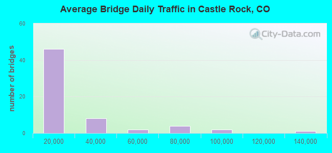
- 1,184,861Total average daily traffic
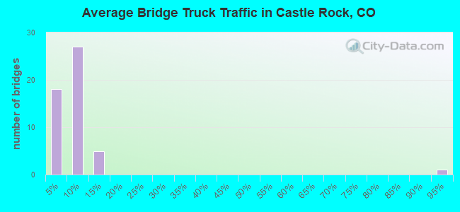
- 85,786Total average daily truck traffic
- National Bridge Inventory (NBI) Registered Bridges for Castle Rock
- No street view available for this location
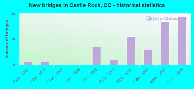
- New bridges - historical statistics
- 11920-1929
- 11930-1939
- 71960-1969
- 21970-1979
- 111980-1989
- 61990-1999
- 172000-2009
- 192010-2019
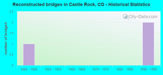
- Reconstructed bridges - Historical Statistics
- 11940-1949
- 01950-1959
- 01960-1969
- 01970-1979
- 01980-1989
- 21990-1999
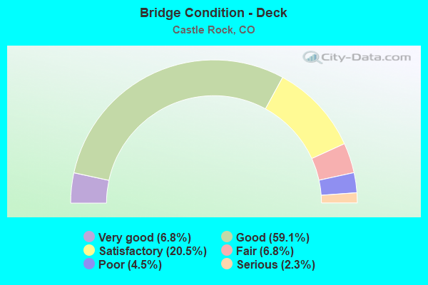
- Bridge Condition - Deck
- 6.8%Very good
- 59.1%Good
- 20.5%Satisfactory
- 6.8%Fair
- 4.5%Poor
- 2.3%Serious
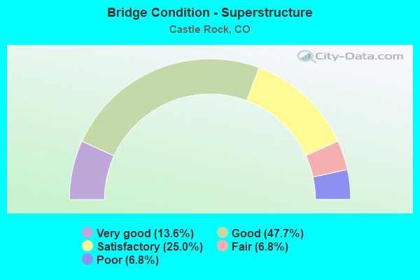
- Bridge Condition - Superstructure
- 13.6%Very good
- 47.7%Good
- 25.0%Satisfactory
- 6.8%Fair
- 6.8%Poor
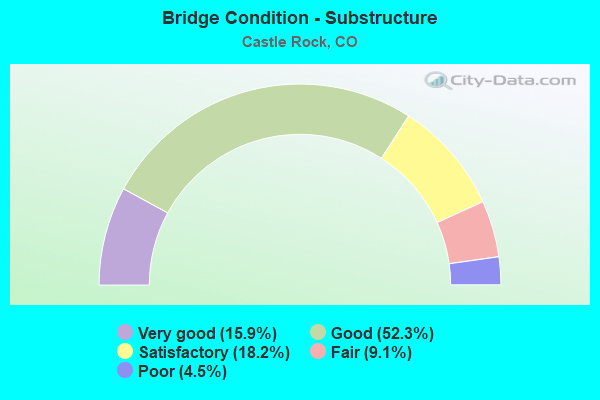
- Bridge Condition - Substructure
- 15.9%Very good
- 52.3%Good
- 18.2%Satisfactory
- 9.1%Fair
- 4.5%Poor
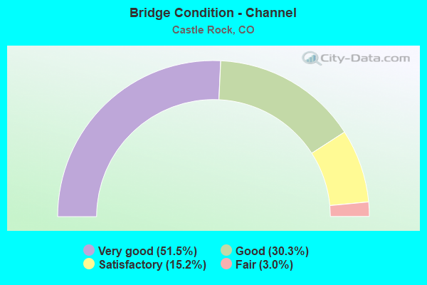
- Bridge Condition - Channel
- 51.5%Very good
- 30.3%Good
- 15.2%Satisfactory
- 3.0%Fair
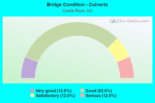
- Bridge Condition - Culverts
- 12.5%Very good
- 62.5%Good
- 12.5%Satisfactory
- 12.5%Serious
Find on map >> Show street view
Structure Number: G-17-AC, Location: 0.5 MI N CASTLE ROCK BUS. (Lat: 39.387844, Lng: -104.860597), Route carried "on" structure: County highway , Year Built: 1964, Status: Open, Structure Length: 6.53m (21.42ft), Average Daily Traffic: 2,731 (year 2021), Truck Traffic: 11%, Average Future Daily Traffic: 3,660 (year 2041), Design Load: HS 20, Features Intersected: I 25 ML, Facility Carried by Structure: CR107 (Liggett RD)
Minimum Vertical Clearance: 30+ m (98+ ft), Kilometerpoint: 0.131, Lanes on structure: 2, Lanes under structure: 6, Owner: State Highway Agency, Approaching Roadway Width: 9.1m (29.9ft), Skew: 9 degrees, Material/Design: Steel, Design/Construction: Stringer/Multi-beam, Number Of Spans In Main Unit: 4, Length of Maximum Span: 19.1m (62.7ft), Curb or Sidewalk Widths: Left: 0.6m (2.0ft), Right: 0.6m (2.0ft), Curb-To-Curb Width: 9.1m (29.9ft), Out-to-Out Width: 10.4m (34.1ft)
Condition: Deck: Serious, Superstructure: Poor, Substructure: Poor, Operating Rating: 49.9 metric tons, Method Used To Determine Operating Rating: Load Factor (LF), Inventory Rating: 29.8 metric tons, Method Used To Determine Inventory Rating: Load Factor (LF), Structural Evaluation: Meets minimum limits, Deck Geometry: Meets minimum limits, Underclear: Equal to present minimum criteria, Approach Roadway Alignment: Somewhat better than minimum adequacy, Length Of Structure Improvement: 6.52m (21.39ft), Designated Inspection Frequency: Every 12 months, Inspection Date: August 2021, Bridge Improvement Cost: $1,083,000, Roadway Improvement Cost: $108,000, Total Project Cost: $1,624,000 ( Estimate for 2017), Deck Structure Type: Concrete Cast-file-Place, Wearing Surface/Protective System: Wearing Surface: Bituminous
Find on map >> Show street view
Structure Number: G-17-AG, Location: 5.1 MI N CASTLE ROCK BUS. (Lat: 39.449922, Lng: -104.875336), Route carried "on" structure: City street , Year Built: 1965, Status: Open, Structure Length: 5.16m (16.93ft), Average Daily Traffic: 5,917 (year 2021), Truck Traffic: 10%, Average Future Daily Traffic: 7,928 (year 2041), Design Load: HS 20, Features Intersected: I 25 ML, Facility Carried by Structure: HAPPY CANYON ROAD
Minimum Vertical Clearance: 30+ m (98+ ft), Kilometerpoint: 0.028, Lanes on structure: 2, Lanes under structure: 8, Owner: State Highway Agency, Approaching Roadway Width: 9.8m (32.2ft), Material/Design: Prestressed concrete, Design/Construction: Stringer/Multi-beam, Number Of Spans In Main Unit: 2, Length of Maximum Span: 25.9m (85.0ft), Curb or Sidewalk Widths: Left: 0.6m (2.0ft), Right: 0.6m (2.0ft), Curb-To-Curb Width: 8.5m (27.9ft), Out-to-Out Width: 9.8m (32.2ft)
Condition: Deck: Poor, Superstructure: Satisfactory, Substructure: Fair, Operating Rating: 47.4 metric tons, Method Used To Determine Operating Rating: Load Factor (LF), Inventory Rating: 22.7 metric tons, Method Used To Determine Inventory Rating: Load Factor (LF), Structural Evaluation: Somewhat better than minimum adequacy, Deck Geometry: High priority of replacement, Underclear: Somewhat better than minimum adequacy, Approach Roadway Alignment: Equal to present minimum criteria, Designated Inspection Frequency: Every 24 months, Inspection Date: August 2021, Deck Structure Type: Concrete Cast-file-Place, Wearing Surface/Protective System: Wearing Surface: Bituminous, Membrane: Preformed Fabric
Find on map >> Show street view
Structure Number: G-17-AL, Location: 2.7 ME S OF JCT SH 67 (Lat: 39.394214, Lng: -104.949903), Route carried "on" structure: State highway 105B, Year Built: 1938, Status: Temporarily open, Structure Length: 2.85m (9.35ft), Average Daily Traffic: 2,600 (year 2020), Truck Traffic: 5%, Average Future Daily Traffic: 3,406 (year 2040), Design Load: H 15, Features Intersected: DRAW, Facility Carried by Structure: SH 105 ML
Minimum Vertical Clearance: 30+ m (98+ ft), Kilometerpoint: 2.763, Lanes on structure: 2, Owner: State Highway Agency, Approaching Roadway Width: 6.1m (20.0ft), Material/Design: Wood or Timber, Design/Construction: Stringer/Multi-beam, Number Of Spans In Main Unit: 4, Length of Maximum Span: 7.0m (23.0ft), Curb-To-Curb Width: 7.6m (24.9ft), Out-to-Out Width: 7.9m (25.9ft)
Condition: Deck: Fair, Superstructure: Poor, Substructure: Fair, Channel: Very good, Operating Rating: 35.2 metric tons, Method Used To Determine Operating Rating: Allowable Stress (AS), Inventory Rating: 24.1 metric tons, Method Used To Determine Inventory Rating: Allowable Stress (AS), Structural Evaluation: Meets minimum limits, Deck Geometry: High priority of replacement, Waterway Adequacy: Equal to present desirable criteria, Approach Roadway Alignment: Equal to present desirable criteria, Length Of Structure Improvement: 3.78m (12.40ft), Designated Inspection Frequency: Every 24 months, Inspection Date: April 2021, Bridge Improvement Cost: $387,000, Roadway Improvement Cost: $39,000, Total Project Cost: $581,000, Deck Structure Type: Wood or Timber, Wearing Surface/Protective System: Wearing Surface: Bituminous
Find on map >> Show street view
Structure Number: G-17-AM, Location: JCT I25 (Lat: 39.412347, Lng: -104.868347), Route carried "on" structure: State highway 86B, Year Built: 1999, Status: Open, Structure Length: 7.07m (23.20ft), Average Daily Traffic: 36,000 (year 2020), Truck Traffic: 3%, Average Future Daily Traffic: 36,720 (year 2040), Design Load: HS 20, Features Intersected: I 25 ML
Minimum Vertical Clearance: 30+ m (98+ ft), Kilometerpoint: 0.039, Lanes on structure: 7, Lanes under structure: 8, Base Highway Network: Yes, Owner: State Highway Agency, Approaching Roadway Width: 27.6m (90.6ft), Skew: 20 degrees, Material/Design: Prestressed concrete, Design/Construction: Box Beam or Girders - Multiple, Number Of Spans In Main Unit: 2, Length of Maximum Span: 35.0m (114.8ft), Curb or Sidewalk Widths: Left: 2.5m (8.2ft), Right: 2.5m (8.2ft), Curb-To-Curb Width: 27.6m (90.6ft), Out-to-Out Width: 34.8m (114.2ft)
Condition: Deck: Satisfactory, Superstructure: Satisfactory, Substructure: Satisfactory, Operating Rating: 71.5 metric tons, Method Used To Determine Operating Rating: Load Factor (LF), Inventory Rating: 14.8 metric tons, Method Used To Determine Inventory Rating: Load Factor (LF), Structural Evaluation: High priority of corrective action, Deck Geometry: Somewhat better than minimum adequacy, Underclear: Somewhat better than minimum adequacy, Approach Roadway Alignment: Equal to present desirable criteria, Designated Inspection Frequency: Every 24 months, Inspection Date: November 2021, Deck Structure Type: Concrete Cast-file-Place, Wearing Surface/Protective System: Wearing Surface: Monolithic Concrete, Deck Protection: Epoxy Coated Reinforcing
Find on map >> Show street view
Structure Number: G-17-BH, Location: N. OF CASTLE ROCK BUS. RT (Lat: 39.380033, Lng: -104.861089), Route carried "on" structure: City street , Year Built: 2002, Status: Open, Structure Length: 6.18m (20.28ft), Average Daily Traffic: 21,632 (year 2021), Truck Traffic: 11%, Average Future Daily Traffic: 28,987 (year 2041), Design Load: HS 25 or greater, Features Intersected: I 25 ML, Facility Carried by Structure: WOLFENSBERGER RD.
Minimum Vertical Clearance: 30+ m (98+ ft), Kilometerpoint: 0.114, Lanes on structure: 6, Lanes under structure: 6, Owner: State Highway Agency, Approaching Roadway Width: 24.7m (81.0ft), Skew: 20 degrees, Material/Design: Prestressed concrete continuous, Design/Construction: Box Beam or Girders - Multiple, Number Of Spans In Main Unit: 2, Length of Maximum Span: 31.4m (103.0ft), Curb or Sidewalk Widths: Left: 0.0m, Right: 2.4m (7.9ft), Curb-To-Curb Width: 24.7m (81.0ft), Out-to-Out Width: 28.0m (91.9ft)
Condition: Deck: Satisfactory, Superstructure: Satisfactory, Substructure: Satisfactory, Operating Rating: 64.0 metric tons, Method Used To Determine Operating Rating: Load Factor (LF), Inventory Rating: 38.4 metric tons, Method Used To Determine Inventory Rating: Load Factor (LF), Structural Evaluation: Equal to present minimum criteria, Deck Geometry: Somewhat better than minimum adequacy, Underclear: Meets minimum limits, Approach Roadway Alignment: Equal to present desirable criteria, Designated Inspection Frequency: Every 24 months, Inspection Date: August 2021, Deck Structure Type: Concrete Cast-file-Place, Wearing Surface/Protective System: Wearing Surface: Monolithic Concrete, Deck Protection: Epoxy Coated Reinforcing
Find on map >> Show street view
Structure Number: G-17-BI, Location: W OF I25 IN CASTLE ROCK (Lat: 39.380322, Lng: -104.861678), Route carried "on" structure: Interstate 25A, Year Built: 2003, Status: Open, Structure Length: 5.94m (19.49ft), Average Daily Traffic: 82,000 (year 2020), Truck Traffic: 6%, Average Future Daily Traffic: 124,640 (year 2040), Design Load: HS 25 or greater, Features Intersected: PLUM CREEK, Facility Carried by Structure: WOLFENSBERGER
Minimum Vertical Clearance: 30+ m (98+ ft), Kilometerpoint: 0.317, Lanes on structure: 5, Base Highway Network: Yes, Owner: State Highway Agency, Approaching Roadway Width: 27.1m (88.9ft), Skew: 20 degrees, Material/Design: Steel continuous, Design/Construction: Stringer/Multi-beam, Number Of Spans In Main Unit: 2, Length of Maximum Span: 29.3m (96.1ft), Curb or Sidewalk Widths: Left: 0.0m, Right: 2.4m (7.9ft), Curb-To-Curb Width: 24.4m (80.1ft), Out-to-Out Width: 27.1m (88.9ft)
Condition: Deck: Satisfactory, Superstructure: Satisfactory, Substructure: Satisfactory, Channel: Very good, Inventory Rating: 28.8 metric tons, Method Used To Determine Inventory Rating: Load Factor (LF), Structural Evaluation: Equal to present minimum criteria, Deck Geometry: Equal to present minimum criteria, Waterway Adequacy: Equal to present desirable criteria, Approach Roadway Alignment: Equal to present desirable criteria, Designated Inspection Frequency: Every 24 months, Inspection Date: August 2021, Deck Structure Type: Concrete Cast-file-Place, Wearing Surface/Protective System: Wearing Surface: Monolithic Concrete, Deck Protection: Epoxy Coated Reinforcing
Find on map >> Show street view
Structure Number: G-17-CE, Location: 1 MI W OF FRANKTOWN (Lat: 39.393378, Lng: -104.773164), Route carried "on" structure: State highway 86A, Year Built: 2002, Status: Open, Structure Length: 1.21m (3.97ft), Average Daily Traffic: 10,000 (year 2020), Truck Traffic: 3%, Average Future Daily Traffic: 11,400 (year 2040), Design Load: HS 25 or greater, Features Intersected: Mitchell Gulch, Facility Carried by Structure: SH 86 ML
Minimum Vertical Clearance: 30+ m (98+ ft), Kilometerpoint: 6.294, Lanes on structure: 2, Base Highway Network: Yes, Owner: State Highway Agency, Approaching Roadway Width: 7.9m (25.9ft), Material/Design: Prestressed concrete, Design/Construction: Box Beam or Girders - Multiple, Number Of Spans In Main Unit: 1, Length of Maximum Span: 11.4m (37.4ft), Curb-To-Curb Width: 12.2m (40.0ft), Out-to-Out Width: 13.1m (43.0ft)
Condition: Deck: Good, Superstructure: Good, Substructure: Good, Channel: Very good, Operating Rating: 85.4 metric tons, Method Used To Determine Operating Rating: Load Factor (LF), Inventory Rating: 47.9 metric tons, Method Used To Determine Inventory Rating: Load Factor (LF), Structural Evaluation: Better than present minimum criteria, Deck Geometry: Somewhat better than minimum adequacy, Waterway Adequacy: Equal to present desirable criteria, Approach Roadway Alignment: Equal to present desirable criteria, Designated Inspection Frequency: Every 24 months, Inspection Date: November 2021, Deck Structure Type: Other, Wearing Surface/Protective System: Wearing Surface: Bituminous, Membrane: Preformed Fabric
Find on map >> Show street view
Structure Number: G-17-CT, Location: 6.7 MI N CASTLE ROCK BUS. (Lat: 39.471958, Lng: -104.873083), Route carried "on" structure: City street , Year Built: 2005, Status: Open, Structure Length: 7.56m (24.80ft), Average Daily Traffic: 18,692 (year 2021), Truck Traffic: 3%, Average Future Daily Traffic: 25,048 (year 2041), Design Load: HL 93, Features Intersected: I 25 ML, Facility Carried by Structure: CASTLE PINES PKWY
Minimum Vertical Clearance: 30+ m (98+ ft), Kilometerpoint: 3.847, Lanes on structure: 6, Lanes under structure: 9, Owner: State Highway Agency, Approaching Roadway Width: 29.9m (98.1ft), Skew: 20 degrees, Material/Design: Prestressed concrete, Design/Construction: Stringer/Multi-beam, Number Of Spans In Main Unit: 2, Length of Maximum Span: 38.1m (125.0ft), Curb or Sidewalk Widths: Left: 1.7m (5.6ft), Right: 1.7m (5.6ft), Curb-To-Curb Width: 25.6m (84.0ft), Out-to-Out Width: 29.9m (98.1ft)
Condition: Deck: Satisfactory, Superstructure: Satisfactory, Substructure: Satisfactory, Operating Rating: 48.6 metric tons, Method Used To Determine Operating Rating: Load and Resistance Factor Rating (LRFR) rating reported by rating factor(RF) method using HL-93 loadings, Inventory Rating: 38.9 metric tons, Method Used To Determine Inventory Rating: Load and Resistance Factor Rating (LRFR) rating reported by rating factor(RF) method using HL-93 loadings, Structural Evaluation: Equal to present minimum criteria, Deck Geometry: Somewhat better than minimum adequacy, Underclear: High priority of corrective action, Approach Roadway Alignment: Equal to present desirable criteria, Designated Inspection Frequency: Every 24 months, Inspection Date: August 2021, Deck Structure Type: Concrete Cast-file-Place, Wearing Surface/Protective System: Wearing Surface: Monolithic Concrete, Deck Protection: Epoxy Coated Reinforcing
Find on map >> Show street view
Structure Number: G-17-DX, Location: WEST OF CASTLE ROCK BUS.D (Lat: 39.371375, Lng: -104.863744), Route carried "on" structure: Interstate 25A, Year Built: 2010, Status: Open, Structure Length: 6.48m (21.26ft), Average Daily Traffic: 41,000 (year 2020), Truck Traffic: 6%, Average Future Daily Traffic: 62,320 (year 2040), Design Load: HS 25 or greater, Features Intersected: EAST PLUM CREEK, Facility Carried by Structure: I 25 ML NBND
Minimum Vertical Clearance: 30+ m (98+ ft), Kilometerpoint: 291.451, Lanes on structure: 4, Base Highway Network: Yes, Owner: State Highway Agency, Approaching Roadway Width: 19.7m (64.6ft), Skew: 32 degrees, Material/Design: Prestressed concrete continuous, Design/Construction: Stringer/Multi-beam, Number Of Spans In Main Unit: 2, Length of Maximum Span: 32.0m (105.0ft), Curb-To-Curb Width: 19.7m (64.6ft), Out-to-Out Width: 20.6m (67.6ft)
Condition: Deck: Good, Superstructure: Very good, Substructure: Good, Channel: Satisfactory, Operating Rating: 49.1 metric tons, Method Used To Determine Operating Rating: Load Factor (LF), Inventory Rating: 29.5 metric tons, Method Used To Determine Inventory Rating: Load Factor (LF), Structural Evaluation: Better than present minimum criteria, Deck Geometry: Equal to present minimum criteria, Waterway Adequacy: Equal to present desirable criteria, Approach Roadway Alignment: Equal to present desirable criteria, Designated Inspection Frequency: Every 24 months, Inspection Date: May 2021, Deck Structure Type: Concrete Precast Panels, Wearing Surface/Protective System: Wearing Surface: Monolithic Concrete, Deck Protection: Epoxy Coated Reinforcing
Find on map >> Show street view
Structure Number: G-17-DY, Location: 0.6 MI. S. CASTLE ROCK BU (Lat: 39.371472, Lng: -104.863944), Route carried "on" structure: Interstate 25A, Year Built: 2010, Status: Open, Structure Length: 6.48m (21.26ft), Average Daily Traffic: 41,000 (year 2020), Truck Traffic: 6%, Average Future Daily Traffic: 62,320 (year 2040), Design Load: HS 25 or greater, Features Intersected: EAST PLUM CREEK, Facility Carried by Structure: I 25 ML SBND
Minimum Vertical Clearance: 30+ m (98+ ft), Kilometerpoint: 291.457, Lanes on structure: 4, Base Highway Network: Yes, Owner: State Highway Agency, Approaching Roadway Width: 19.7m (64.6ft), Skew: 32 degrees, Material/Design: Prestressed concrete continuous, Design/Construction: Stringer/Multi-beam, Number Of Spans In Main Unit: 2, Length of Maximum Span: 32.0m (105.0ft), Curb-To-Curb Width: 19.7m (64.6ft), Out-to-Out Width: 20.6m (67.6ft)
Condition: Deck: Good, Superstructure: Good, Substructure: Good, Channel: Satisfactory, Operating Rating: 58.0 metric tons, Method Used To Determine Operating Rating: Load and Resistance Factor Rating (LRFR) rating reported by rating factor(RF) method using HL-93 loadings, Inventory Rating: 44.7 metric tons, Method Used To Determine Inventory Rating: Load and Resistance Factor Rating (LRFR) rating reported by rating factor(RF) method using HL-93 loadings, Structural Evaluation: Better than present minimum criteria, Deck Geometry: Equal to present minimum criteria, Waterway Adequacy: Equal to present desirable criteria, Approach Roadway Alignment: Equal to present desirable criteria, Designated Inspection Frequency: Every 24 months, Inspection Date: June 2021, Deck Structure Type: Concrete Precast Panels, Wearing Surface/Protective System: Wearing Surface: Monolithic Concrete, Deck Protection: Epoxy Coated Reinforcing
Find on map >> Show street view
Structure Number: G-17-DZ, Location: S. END OF CASTLE ROCK (Lat: 39.366239, Lng: -104.865611), Route carried "on" structure: Interstate 25A, Year Built: 2010, Status: Open, Structure Length: 4.11m (13.48ft), Average Daily Traffic: 33,000 (year 2020), Truck Traffic: 9%, Average Future Daily Traffic: 46,860 (year 2040), Design Load: HS 25 or greater, Features Intersected: PLUM CREEK PARKWAY, Facility Carried by Structure: I 25 ML SBND
Minimum Vertical Clearance: 30+ m (98+ ft), Kilometerpoint: 290.860, Lanes on structure: 3, Lanes under structure: 6, Base Highway Network: Yes, Owner: State Highway Agency, Approaching Roadway Width: 17.2m (56.4ft), Skew: 30 degrees, Material/Design: Prestressed concrete, Design/Construction: Box Beam or Girders - Multiple, Number Of Spans In Main Unit: 1, Length of Maximum Span: 40.4m (132.5ft), Curb-To-Curb Width: 17.2m (56.4ft), Out-to-Out Width: 18.1m (59.4ft)
Condition: Deck: Good, Superstructure: Good, Substructure: Good, Inventory Rating: 58.2 metric tons, Method Used To Determine Inventory Rating: Load Factor (LF), Structural Evaluation: Better than present minimum criteria, Deck Geometry: Better than present minimum criteria, Underclear: Superior to present desirable criteria, Approach Roadway Alignment: Equal to present desirable criteria, Designated Inspection Frequency: Every 24 months, Inspection Date: May 2021, Deck Structure Type: Concrete Cast-file-Place, Wearing Surface/Protective System: Wearing Surface: Monolithic Concrete, Deck Protection: Epoxy Coated Reinforcing
Find on map >> Show street view
Structure Number: G-17-EA, Location: 8.9 MI N. OF JCT S.H. 18 (Lat: 39.366194, Lng: -104.865400), Route carried "on" structure: Interstate 25A, Year Built: 2010, Status: Open, Structure Length: 4.11m (13.48ft), Average Daily Traffic: 33,000 (year 2020), Truck Traffic: 9%, Average Future Daily Traffic: 46,860 (year 2040), Design Load: HS 25 or greater, Features Intersected: PLUM CREEK PARKWAY, Facility Carried by Structure: I 25 ML NBND
Minimum Vertical Clearance: 30+ m (98+ ft), Kilometerpoint: 290.860, Lanes on structure: 3, Lanes under structure: 6, Base Highway Network: Yes, Owner: State Highway Agency, Approaching Roadway Width: 17.2m (56.4ft), Skew: 30 degrees, Material/Design: Prestressed concrete, Design/Construction: Box Beam or Girders - Multiple, Number Of Spans In Main Unit: 1, Length of Maximum Span: 40.4m (132.5ft), Curb-To-Curb Width: 17.2m (56.4ft), Out-to-Out Width: 18.1m (59.4ft)
Condition: Deck: Good, Superstructure: Good, Substructure: Good, Inventory Rating: 66.6 metric tons, Method Used To Determine Inventory Rating: Load Factor (LF), Structural Evaluation: Better than present minimum criteria, Deck Geometry: Better than present minimum criteria, Underclear: Superior to present desirable criteria, Approach Roadway Alignment: Equal to present desirable criteria, Designated Inspection Frequency: Every 24 months, Inspection Date: May 2021, Deck Structure Type: Concrete Cast-file-Place, Wearing Surface/Protective System: Wearing Surface: Monolithic Concrete, Deck Protection: Epoxy Coated Reinforcing
Find on map >> Show street view
Structure Number: CAS CASRKPWY-1, Location: N OF CASTLE ROCK (Lat: 39.424222, Lng: -104.875769), Route carried "under" structure: City street , Year Built: 2015, Structure Length: 0. m, Average Daily Traffic: 1,000 (year 2018), Truck Traffic: 1%, Features Intersected: N MEADOWS PARKWAY, Facility Carried by Structure: I-25 ML NBND
Minimum Vertical Clearance: 16.93m (55.54ft), Kilometerpoint: 0.000, Lanes on structure: 5, Lanes under structure: 2, Material/Design: Prestressed concrete, Design/Construction: Stringer/Multi-beam, Length of Maximum Span: 31.5m (103.3ft)
Find on map >> Show street view
Structure Number: CAS CASRKPWY-2, Location: N OF CASTLE ROCK (Lat: 39.429747, Lng: -104.876008), Route carried "under" structure: City street , Year Built: 2015, Structure Length: 0. m, Average Daily Traffic: 1,000 (year 2018), Features Intersected: N MEADOWS PARKWAY, Facility Carried by Structure: I-25 ML SBND
Minimum Vertical Clearance: 16.93m (55.54ft), Kilometerpoint: 0.000, Lanes on structure: 4, Lanes under structure: 2, Material/Design: Prestressed concrete, Design/Construction: Stringer/Multi-beam, Length of Maximum Span: 31.5m (103.3ft)
Find on map >> Show street view
Structure Number: CAS CASRKPWY-3, Location: NBND ON RAMP A (Lat: 39.420211, Lng: -104.888297), Route carried "under" structure: City street , Year Built: 2014, Structure Length: 0. m, Average Daily Traffic: 20,000 (year 2018), Features Intersected: TERRAIN, Facility Carried by Structure: US 85 NB ON RAMP
Minimum Vertical Clearance: 16.93m (55.54ft), Kilometerpoint: 0.000, Lanes on structure: 2, Material/Design: Prestressed concrete continuous, Design/Construction: Stringer/Multi-beam, Length of Maximum Span: 32.0m (105.0ft)
Find on map >> Show street view
Structure Number: CAS CASRKPWY-4, Location: US85 NBND OFFRAMP (Lat: 39.420769, Lng: -104.889142), Route carried "under" structure: 85B, Year Built: 2014, Structure Length: 0. m, Average Daily Traffic: 20,000 (year 2018), Features Intersected: TERRAIN, Facility Carried by Structure: US 85 OFF RAMP
Minimum Vertical Clearance: 16.93m (55.54ft), Kilometerpoint: 1.394, Lanes on structure: 2, Material/Design: Prestressed concrete continuous, Design/Construction: Stringer/Multi-beam, Length of Maximum Span: 37.8m (124.0ft)
Find on map >> Show street view
Structure Number: CAS FIFTH-I25, Location: 0.1 MI W OF WILCOX (Lat: 39.374758, Lng: -104.864711), Route carried "under" structure: Interstate 25A, Year Built: 2001, Structure Length: 0. m, Average Daily Traffic: 68,100 (year 2008), Truck Traffic: 9%, Features Intersected: I25 ML AND E. PLUM CK, Facility Carried by Structure: 5TH ST.
Minimum Vertical Clearance: 30+ m (98+ ft), Kilometerpoint: 0.023, Lanes on structure: 2, Lanes under structure: 4, Material/Design: Steel continuous, Design/Construction: Stringer/Multi-beam, Length of Maximum Span: 65.9m (216.2ft)
Find on map >> Show street view
Structure Number: CAS FRONT-RR, Location: N OF 6TH STREET (Lat: 39.376194, Lng: -104.858483), Route carried "under" structure: City street , Year Built: 2004, Structure Length: 0. m, Features Intersected: RAILROAD / 7TH ST, Facility Carried by Structure: FRONT ST
Minimum Vertical Clearance: 4.98m (16.34ft), Kilometerpoint: 0.000, Lanes on structure: 2, Lanes under structure: 2, Material/Design: Prestressed concrete continuous, Design/Construction: Stringer/Multi-beam, Length of Maximum Span: 42.6m (139.8ft)
Find on map >> Show street view
Structure Number: CAS OLD85-I25, Location: JUST W OF FRONT ST. (Lat: 39.400250, Lng: -104.862206), Route carried "under" structure: Interstate 25A, Year Built: 2002, Structure Length: 0. m, Average Daily Traffic: 76,300 (year 2008), Truck Traffic: 10%, Features Intersected: I25 ML, Facility Carried by Structure: SANTE FE DR.
Minimum Vertical Clearance: 30+ m (98+ ft), Kilometerpoint: 1.572, Lanes on structure: 4, Lanes under structure: 8, Material/Design: Prestressed concrete continuous, Design/Construction: Stringer/Multi-beam, Length of Maximum Span: 38.4m (126.0ft)
Find on map >> Show street view
Structure Number: G-17-AC, Location: 0.5 MI N CASTLE ROCK BUS. (Lat: 39.387844, Lng: -104.860597), Route carried "under" structure: Interstate 25A, Year Built: 1964, Structure Length: 0. m, Average Daily Traffic: 2,799 (year 2016), Truck Traffic: 9%, Features Intersected: I 25 ML, Facility Carried by Structure: CR107 (Liggett RD)
Minimum Vertical Clearance: 5.18m (16.99ft), Kilometerpoint: 0.130, Lanes on structure: 2, Lanes under structure: 4, Material/Design: Steel, Design/Construction: Stringer/Multi-beam, Length of Maximum Span: 19.1m (62.7ft)
Find on map >> Show street view
Structure Number: G-17-AG, Location: 5.1 MI N CASTLE ROCK BUS. (Lat: 39.449922, Lng: -104.875336), Route carried "under" structure: Interstate 25A, Year Built: 1965, Structure Length: 0. m, Average Daily Traffic: 130,000 (year 2018), Truck Traffic: 9%, Features Intersected: I 25 ML, Facility Carried by Structure: HAPPY CANYON ROAD
Minimum Vertical Clearance: 5.51m (18.08ft), Kilometerpoint: 0.029, Lanes on structure: 2, Lanes under structure: 6, Material/Design: Prestressed concrete, Design/Construction: Stringer/Multi-beam, Length of Maximum Span: 25.9m (85.0ft)
Find on map >> Show street view
Structure Number: G-17-AM, Location: JCT I25 (Lat: 39.412347, Lng: -104.868347), Route carried "under" structure: Interstate 25A, Year Built: 1999, Structure Length: 0. m, Average Daily Traffic: 81,000 (year 2011), Truck Traffic: 9%, Features Intersected: I 25 ML, Facility Carried by Structure: SH 86B ML
Minimum Vertical Clearance: 5.56m (18.24ft), Kilometerpoint: 296.397, Lanes on structure: 7, Lanes under structure: 6, Material/Design: Prestressed concrete, Design/Construction: Box Beam or Girders - Multiple, Length of Maximum Span: 35.0m (114.8ft)
Find on map >> Show street view
Structure Number: G-17-BH, Location: N. OF CASTLE ROCK BUS. RT (Lat: 39.380033, Lng: -104.861089), Route carried "under" structure: Interstate 25A, Year Built: 2002, Structure Length: 0. m, Average Daily Traffic: 12,025 (year 2016), Truck Traffic: 9%, Features Intersected: I 25 ML, Facility Carried by Structure: WOLFENSBERGER RD.
Minimum Vertical Clearance: 30+ m (98+ ft), Kilometerpoint: 0.114, Lanes on structure: 6, Lanes under structure: 4, Material/Design: Prestressed concrete continuous, Design/Construction: Box Beam or Girders - Multiple, Length of Maximum Span: 31.4m (103.0ft)
Find on map >> Show street view
Structure Number: G-17-CT, Location: 6.7 MI N CASTLE ROCK BUS. (Lat: 39.471958, Lng: -104.873083), Route carried "under" structure: Interstate 25A, Year Built: 2005, Structure Length: 0. m, Average Daily Traffic: 17,035 (year 2016), Truck Traffic: 9%, Features Intersected: I 25 ML, Facility Carried by Structure: CASTLE PINES PKWY
Minimum Vertical Clearance: 5.28m (17.32ft), Kilometerpoint: 3.848, Lanes on structure: 6, Lanes under structure: 4, Material/Design: Prestressed concrete, Design/Construction: Stringer/Multi-beam, Length of Maximum Span: 38.1m (125.0ft)