Bridge Statistics for Cedar Falls, Iowa (IA)
Condition, Traffic, Stress, Structural Evaluation, Project Costs
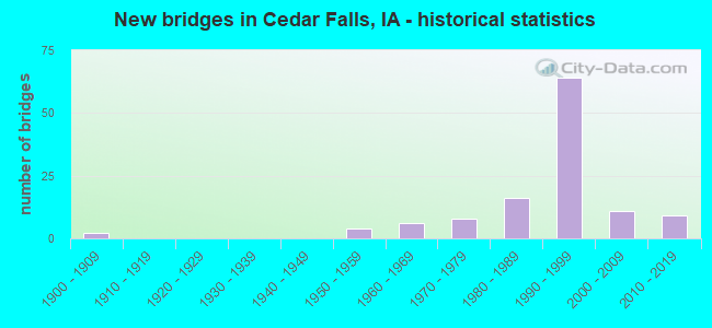
- New bridges - historical statistics
- 21900-1909
- 41950-1959
- 61960-1969
- 81970-1979
- 161980-1989
- 641990-1999
- 112000-2009
- 92010-2019
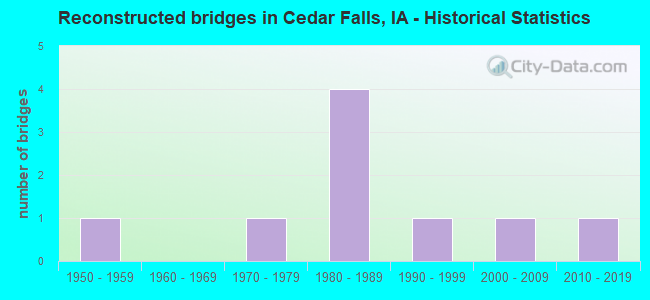
- Reconstructed bridges - Historical Statistics
- 11950-1959
- 01960-1969
- 11970-1979
- 41980-1989
- 11990-1999
- 12000-2009
- 12010-2019
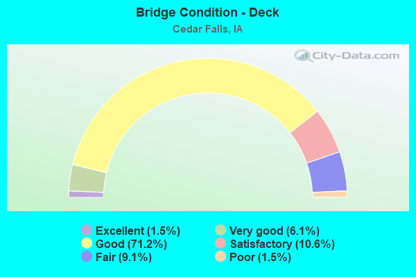
- Bridge Condition - Deck
- 1.5%Excellent
- 6.1%Very good
- 71.2%Good
- 10.6%Satisfactory
- 9.1%Fair
- 1.5%Poor
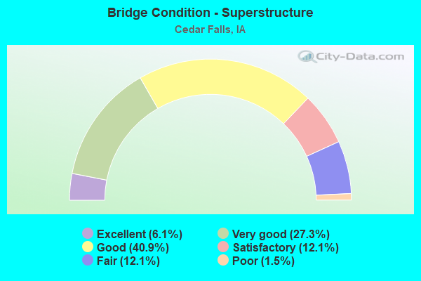
- Bridge Condition - Superstructure
- 6.1%Excellent
- 27.3%Very good
- 40.9%Good
- 12.1%Satisfactory
- 12.1%Fair
- 1.5%Poor
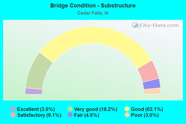
- Bridge Condition - Substructure
- 3.0%Excellent
- 18.2%Very good
- 62.1%Good
- 9.1%Satisfactory
- 4.5%Fair
- 3.0%Poor
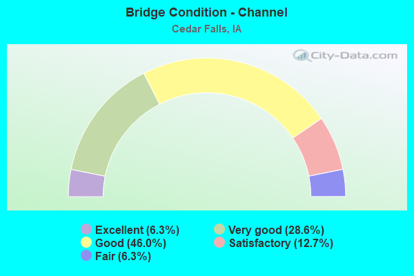
- Bridge Condition - Channel
- 6.3%Excellent
- 28.6%Very good
- 46.0%Good
- 12.7%Satisfactory
- 6.3%Fair
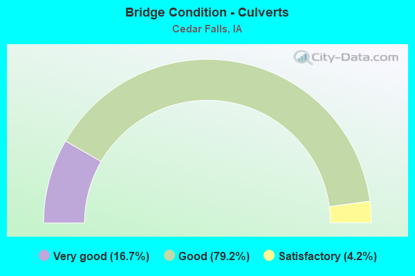
- Bridge Condition - Culverts
- 16.7%Very good
- 79.2%Good
- 4.2%Satisfactory
Find on map >> Show street view
Structure Number: 1045, Location: A15000600 (Lat: 42.469536, Lng: -92.468919), Route carried "on" structure: City street , Year Built: 1900, Year Reconstructed: 2008, Status: Open, Structure Length: 0.91m (2.99ft), Average Daily Traffic: 1,050 (year 2021), Average Future Daily Traffic: 1,050 (year 2040), Features Intersected: S BR DRY RUN, Facility Carried by Structure: W RIDGEWAY AVE
Minimum Vertical Clearance: 30+ m (98+ ft), Kilometerpoint: 0.575, Lanes on structure: 2, Owner: City or Municipal Highway Agency, Approaching Roadway Width: 8.5m (27.9ft), Material/Design: Steel, Design/Construction: Stringer/Multi-beam, Number Of Spans In Main Unit: 1, Length of Maximum Span: 8.8m (28.9ft), Curb-To-Curb Width: 8.3m (27.2ft), Out-to-Out Width: 8.5m (27.9ft)
Condition: Deck: Fair, Superstructure: Fair, Substructure: Poor, Channel: Satisfactory, Operating Rating: 48.5 metric tons, Method Used To Determine Operating Rating: Load Factor (LF), Inventory Rating: 29.0 metric tons, Method Used To Determine Inventory Rating: Load Factor (LF), Structural Evaluation: Meets minimum limits, Deck Geometry: Meets minimum limits, Waterway Adequacy: Equal to present minimum criteria, Approach Roadway Alignment: Equal to present desirable criteria, Length Of Structure Improvement: 5.10m (16.73ft), Designated Inspection Frequency: Every 24 months, Inspection Date: March 2020, Bridge Improvement Cost: $103,000, Roadway Improvement Cost: $17,000, Deck Structure Type: Concrete Cast-file-Place, Wearing Surface/Protective System: Wearing Surface: Monolithic Concrete
Find on map >> Show street view
Structure Number: 1071, Location: A27500731 (Lat: 42.525053, Lng: -92.440917), Route carried "on" structure: City street , Year Built: 1994, Status: Open, Structure Length: 4.33m (14.21ft), Average Daily Traffic: 5,600 (year 2021), Average Future Daily Traffic: 5,600 (year 2040), Design Load: HS 20, Features Intersected: DRY RUN CREEK, Facility Carried by Structure: WATERLOO RD
Minimum Vertical Clearance: 30+ m (98+ ft), Kilometerpoint: 1.799, Lanes on structure: 4, Owner: City or Municipal Highway Agency, Approaching Roadway Width: 15.9m (52.2ft), Skew: 1 degrees, Material/Design: Prestressed concrete continuous, Design/Construction: Stringer/Multi-beam, Number Of Spans In Main Unit: 3, Length of Maximum Span: 15.9m (52.2ft), Curb or Sidewalk Widths: Left: 2.4m (7.9ft), Right: 2.4m (7.9ft), Curb-To-Curb Width: 17.1m (56.1ft), Out-to-Out Width: 26.3m (86.3ft)
Condition: Deck: Good, Superstructure: Good, Substructure: Very good, Channel: Very good, Operating Rating: 41.8 metric tons, Method Used To Determine Operating Rating: Load Factor (LF), Inventory Rating: 25.0 metric tons, Method Used To Determine Inventory Rating: Load Factor (LF), Structural Evaluation: Equal to present minimum criteria, Deck Geometry: Somewhat better than minimum adequacy, Waterway Adequacy: Equal to present desirable criteria, Approach Roadway Alignment: Equal to present desirable criteria, Designated Inspection Frequency: Every 24 months, Inspection Date: March 2020, Deck Structure Type: Concrete Cast-file-Place, Wearing Surface/Protective System: Wearing Surface: Monolithic Concrete, Deck Protection: Epoxy Coated Reinforcing
Find on map >> Show street view
Structure Number: 1091, Location: BTWN FRANKLIN & CLAY ST (Lat: 42.519731, Lng: -92.449061), Route carried "on" structure: City street , Year Built: 2018, Status: Open, Structure Length: 1.32m (4.33ft), Average Daily Traffic: 726 (year 2013), Average Future Daily Traffic: 726 (year 2040), Design Load: HL 93, Features Intersected: DRY RUN CREEK, Facility Carried by Structure: 20TH ST
Minimum Vertical Clearance: 30+ m (98+ ft), Kilometerpoint: 0.948, Lanes on structure: 2, Owner: City or Municipal Highway Agency, Approaching Roadway Width: 9.8m (32.2ft), Skew: 3 degrees, Material/Design: Concrete continuous, Design/Construction: Culvert, Number Of Spans In Main Unit: 3, Length of Maximum Span: 4.2m (13.8ft), Curb or Sidewalk Widths: Left: 0.0m, Right: 2.4m (7.9ft), Curb-To-Curb Width: 9.0m (29.5ft), Out-to-Out Width: 12.0m (39.4ft)
Condition: Channel: Very good, Culverts: Very good, Operating Rating: 40.2 metric tons, Method Used To Determine Operating Rating: Load and Resistance Factor Rating (LRFR) rating reported by rating factor(RF) method using HL-93 loadings, Inventory Rating: 31.1 metric tons, Method Used To Determine Inventory Rating: Load and Resistance Factor Rating (LRFR) rating reported by rating factor(RF) method using HL-93 loadings, Structural Evaluation: Better than present minimum criteria, Deck Geometry: Somewhat better than minimum adequacy, Waterway Adequacy: Better than present minimum criteria, Approach Roadway Alignment: Equal to present desirable criteria, Designated Inspection Frequency: Every 24 months, Inspection Date: March 2020, Wearing Surface/Protective System: Wearing Surface: Monolithic Concrete, Deck Protection: Epoxy Coated Reinforcing
Find on map >> Show street view
Structure Number: 1101, Location: 000000000 (Lat: 42.521908, Lng: -92.443372), Route carried "on" structure: City street , Year Built: 1992, Status: Open, Structure Length: 4.05m (13.29ft), Average Daily Traffic: 4,160 (year 2021), Average Future Daily Traffic: 4,160 (year 2040), Design Load: HS 20, Features Intersected: DRY RUN CREEK, Facility Carried by Structure: E 18TH ST
Minimum Vertical Clearance: 30+ m (98+ ft), Kilometerpoint: 1.838, Lanes on structure: 5, Owner: City or Municipal Highway Agency, Approaching Roadway Width: 24.7m (81.0ft), Skew: 20 degrees, Material/Design: Concrete continuous, Design/Construction: Slab, Number Of Spans In Main Unit: 3, Length of Maximum Span: 15.5m (50.9ft), Curb or Sidewalk Widths: Left: 1.5m (4.9ft), Right: 1.5m (4.9ft), Curb-To-Curb Width: 29.3m (96.1ft), Out-to-Out Width: 33.8m (110.9ft)
Condition: Deck: Good, Superstructure: Good, Substructure: Good, Channel: Good, Operating Rating: 77.5 metric tons, Method Used To Determine Operating Rating: Load Factor (LF), Inventory Rating: 46.4 metric tons, Method Used To Determine Inventory Rating: Load Factor (LF), Structural Evaluation: Better than present minimum criteria, Deck Geometry: Superior to present desirable criteria, Waterway Adequacy: Better than present minimum criteria, Approach Roadway Alignment: Equal to present desirable criteria, Designated Inspection Frequency: Every 24 months, Inspection Date: March 2020, Deck Structure Type: Concrete Cast-file-Place, Wearing Surface/Protective System: Wearing Surface: Monolithic Concrete, Deck Protection: Epoxy Coated Reinforcing
Find on map >> Show street view
Structure Number: 1104, Location: A53050770 (Lat: 42.554008, Lng: -92.495417), Route carried "on" structure: City street , Year Built: 1999, Status: Open, Structure Length: 4.72m (15.49ft), Average Daily Traffic: 2,140 (year 2021), Average Future Daily Traffic: 2,140 (year 2040), Design Load: HS 20, Features Intersected: CC RR, Facility Carried by Structure: UNION RD
Minimum Vertical Clearance: 30+ m (98+ ft), Kilometerpoint: 6.954, Lanes on structure: 2, Owner: City or Municipal Highway Agency, Approaching Roadway Width: 11.0m (36.1ft), Skew: 2 degrees, Material/Design: Prestressed concrete continuous, Design/Construction: Stringer/Multi-beam, Number Of Spans In Main Unit: 3, Length of Maximum Span: 21.0m (68.9ft), Curb-To-Curb Width: 11.0m (36.1ft), Out-to-Out Width: 11.9m (39.0ft)
Condition: Deck: Good, Superstructure: Very good, Substructure: Very good, Operating Rating: 45.1 metric tons, Method Used To Determine Operating Rating: Load Factor (LF), Inventory Rating: 27.0 metric tons, Method Used To Determine Inventory Rating: Load Factor (LF), Structural Evaluation: Equal to present minimum criteria, Deck Geometry: Somewhat better than minimum adequacy, Underclear: High priority of replacement, Approach Roadway Alignment: Equal to present minimum criteria, Length Of Structure Improvement: 3.40m (11.15ft), Designated Inspection Frequency: Every 24 months, Inspection Date: March 2020, Bridge Improvement Cost: $404,000, Roadway Improvement Cost: $61,000, Deck Structure Type: Concrete Cast-file-Place, Wearing Surface/Protective System: Wearing Surface: Monolithic Concrete, Deck Protection: Epoxy Coated Reinforcing
Find on map >> Show street view
Structure Number: 1111, Location: 000000000 (Lat: 42.518992, Lng: -92.458869), Route carried "on" structure: City street , Year Built: 2016, Status: Open, Structure Length: 0.87m (2.85ft), Average Daily Traffic: 112 (year 1981), Average Future Daily Traffic: 112 (year 2040), Design Load: HL 93, Features Intersected: DRAINAGE, Facility Carried by Structure: MERNER AVE
Minimum Vertical Clearance: 30+ m (98+ ft), Kilometerpoint: 0.249, Lanes on structure: 2, Owner: City or Municipal Highway Agency, Approaching Roadway Width: 9.4m (30.8ft), Material/Design: Concrete continuous, Design/Construction: Culvert, Number Of Spans In Main Unit: 2, Length of Maximum Span: 4.3m (14.1ft)
Condition: Channel: Very good, Culverts: Very good, Operating Rating: 43.1 metric tons, Method Used To Determine Operating Rating: Load and Resistance Factor Rating (LRFR) rating reported by rating factor(RF) method using HL-93 loadings, Inventory Rating: 33.4 metric tons, Method Used To Determine Inventory Rating: Load and Resistance Factor Rating (LRFR) rating reported by rating factor(RF) method using HL-93 loadings, Structural Evaluation: Equal to present desirable criteria, Waterway Adequacy: Better than present minimum criteria, Approach Roadway Alignment: Equal to present desirable criteria, Designated Inspection Frequency: Every 24 months, Inspection Date: March 2020
Find on map >> Show street view
Structure Number: 1121, Location: 000000000 (Lat: 42.519239, Lng: -92.455781), Route carried "on" structure: City street , Year Built: 2007, Status: Open, Structure Length: 0.76m (2.49ft), Average Daily Traffic: 9,800 (year 2014), Average Future Daily Traffic: 9,800 (year 2040), Design Load: HS 20, Features Intersected: DRAINAGE, Facility Carried by Structure: COLLEGE ST
Minimum Vertical Clearance: 30+ m (98+ ft), Kilometerpoint: 0.884, Lanes on structure: 2, Owner: City or Municipal Highway Agency, Approaching Roadway Width: 8.8m (28.9ft), Material/Design: Concrete continuous, Design/Construction: Culvert, Number Of Spans In Main Unit: 2, Length of Maximum Span: 3.7m (12.1ft)
Condition: Channel: Good, Culverts: Very good, Operating Rating: 41.2 metric tons, Method Used To Determine Operating Rating: Load Factor (LF), Inventory Rating: 24.5 metric tons, Method Used To Determine Inventory Rating: Load Factor (LF), Structural Evaluation: Equal to present minimum criteria, Waterway Adequacy: Equal to present desirable criteria, Approach Roadway Alignment: Equal to present desirable criteria, Designated Inspection Frequency: Every 24 months, Inspection Date: March 2020
Find on map >> Show street view
Structure Number: 113, Location: 000000000 (Lat: 42.519253, Lng: -92.454706), Route carried "on" structure: City street , Year Built: 1900, Year Reconstructed: 1955, Status: Posted for load, Structure Length: 0.91m (2.99ft), Average Daily Traffic: 486 (year 2013), Average Future Daily Traffic: 486 (year 2040), Features Intersected: DRAINAGE, Facility Carried by Structure: OLIVE ST
Minimum Vertical Clearance: 30+ m (98+ ft), Kilometerpoint: 0.676, Lanes on structure: 2, Owner: City or Municipal Highway Agency, Approaching Roadway Width: 7.3m (24.0ft), Material/Design: Concrete continuous, Design/Construction: Slab, Number Of Spans In Main Unit: 2, Length of Maximum Span: 5.2m (17.1ft), Curb-To-Curb Width: 7.4m (24.3ft), Out-to-Out Width: 8.0m (26.2ft)
Condition: Deck: Poor, Superstructure: Poor, Substructure: Satisfactory, Channel: Fair, Operating Rating: 24.4 metric tons, Method Used To Determine Operating Rating: Load Factor (LF), Inventory Rating: 14.6 metric tons, Method Used To Determine Inventory Rating: Load Factor (LF), Structural Evaluation: Meets minimum limits, Deck Geometry: Meets minimum limits, Waterway Adequacy: Equal to present minimum criteria, Approach Roadway Alignment: Better than present minimum criteria, Bridge Posting: Required (Relationship of Operating Rating to Maximum Legal Load: 10.0 - 19.9% below), Length Of Structure Improvement: 5.10m (16.73ft), Designated Inspection Frequency: Every 24 months, Inspection Date: March 2020, Bridge Improvement Cost: $98,000, Roadway Improvement Cost: $16,000, Deck Structure Type: Concrete Cast-file-Place, Wearing Surface/Protective System: Wearing Surface: Bituminous
Find on map >> Show street view
Structure Number: 1141, Location: BTWN 20TH & 21ST STREETS (Lat: 42.519253, Lng: -92.453414), Route carried "on" structure: City street , Year Built: 2019, Status: Open, Structure Length: 0.87m (2.85ft), Average Daily Traffic: 770 (year 1989), Average Future Daily Traffic: 770 (year 2040), Design Load: HL 93, Features Intersected: DRAINAGE, Facility Carried by Structure: WALNUT ST
Minimum Vertical Clearance: 30+ m (98+ ft), Kilometerpoint: 0.884, Lanes on structure: 2, Owner: City or Municipal Highway Agency, Approaching Roadway Width: 10.7m (35.1ft), Material/Design: Concrete continuous, Design/Construction: Culvert, Number Of Spans In Main Unit: 2, Length of Maximum Span: 4.3m (14.1ft)
Condition: Channel: Very good, Culverts: Very good, Operating Rating: 34.7 metric tons, Method Used To Determine Operating Rating: Load and Resistance Factor Rating (LRFR) rating reported by rating factor(RF) method using HL-93 loadings, Inventory Rating: 26.9 metric tons, Method Used To Determine Inventory Rating: Load and Resistance Factor Rating (LRFR) rating reported by rating factor(RF) method using HL-93 loadings, Structural Evaluation: Equal to present minimum criteria, Waterway Adequacy: Better than present minimum criteria, Approach Roadway Alignment: Equal to present desirable criteria, Designated Inspection Frequency: Every 24 months, Inspection Date: March 2020
Find on map >> Show street view
Structure Number: 116, Location: 000000000 (Lat: 42.519864, Lng: -92.448181), Route carried "on" structure: City street , Year Built: 1957, Status: Open, Structure Length: 0.70m (2.30ft), Average Daily Traffic: 320 (year 2021), Average Future Daily Traffic: 320 (year 2040), Features Intersected: DRAINAGE, Facility Carried by Structure: CLAY ST
Minimum Vertical Clearance: 30+ m (98+ ft), Kilometerpoint: 0.435, Lanes on structure: 2, Owner: City or Municipal Highway Agency, Approaching Roadway Width: 9.1m (29.9ft), Material/Design: Concrete continuous, Design/Construction: Slab, Number Of Spans In Main Unit: 2, Length of Maximum Span: 3.0m (9.8ft), Curb or Sidewalk Widths: Left: 7.3m (24.0ft), Right: 2.7m (8.9ft), Curb-To-Curb Width: 9.1m (29.9ft), Out-to-Out Width: 19.1m (62.7ft)
Condition: Deck: Fair, Superstructure: Fair, Substructure: Fair, Channel: Fair, Operating Rating: 33.5 metric tons, Method Used To Determine Operating Rating: Load Factor (LF), Inventory Rating: 20.0 metric tons, Method Used To Determine Inventory Rating: Load Factor (LF), Structural Evaluation: Somewhat better than minimum adequacy, Deck Geometry: Equal to present minimum criteria, Waterway Adequacy: Equal to present minimum criteria, Approach Roadway Alignment: Equal to present minimum criteria, Length Of Structure Improvement: 2.30m (7.55ft), Designated Inspection Frequency: Every 24 months, Inspection Date: March 2020, Bridge Improvement Cost: $24,000, Roadway Improvement Cost: $1,000, Deck Structure Type: Concrete Cast-file-Place, Wearing Surface/Protective System: Wearing Surface: Monolithic Concrete
Find on map >> Show street view
Structure Number: 117, Location: 000000000 (Lat: 42.507675, Lng: -92.445992), Route carried "on" structure: City street , Year Built: 1968, Status: Open, Structure Length: 1.28m (4.20ft), Average Daily Traffic: 6,300 (year 2014), Average Future Daily Traffic: 6,300 (year 2040), Features Intersected: S DRY RUN, Facility Carried by Structure: SO MAIN ST RD
Minimum Vertical Clearance: 30+ m (98+ ft), Kilometerpoint: 2.284, Lanes on structure: 2, Owner: City or Municipal Highway Agency, Approaching Roadway Width: 10.7m (35.1ft), Material/Design: Prestressed concrete, Design/Construction: Tee Beam, Number Of Spans In Main Unit: 1, Length of Maximum Span: 12.2m (40.0ft), Curb or Sidewalk Widths: Left: 1.7m (5.6ft), Right: 1.7m (5.6ft), Curb-To-Curb Width: 14.8m (48.6ft), Out-to-Out Width: 18.6m (61.0ft)
Condition: Deck: Fair, Superstructure: Fair, Substructure: Poor, Channel: Good, Operating Rating: 52.6 metric tons, Method Used To Determine Operating Rating: Load Factor (LF), Inventory Rating: 31.5 metric tons, Method Used To Determine Inventory Rating: Load Factor (LF), Structural Evaluation: Meets minimum limits, Deck Geometry: Superior to present desirable criteria, Waterway Adequacy: Equal to present minimum criteria, Approach Roadway Alignment: Equal to present minimum criteria, Designated Inspection Frequency: Every 24 months, Inspection Date: March 2020, Bridge Improvement Cost: $3,000, Roadway Improvement Cost: $1,000, Deck Structure Type: Concrete Cast-file-Place, Wearing Surface/Protective System: Wearing Surface: Monolithic Concrete
Find on map >> Show street view
Structure Number: 1184, Location: 000000000 (Lat: 42.490292, Lng: -92.411781), Route carried "on" structure: City street , Year Built: 1983, Status: Open, Structure Length: 0.87m (2.85ft), Average Daily Traffic: 10,200 (year 2017), Average Future Daily Traffic: 10,200 (year 2040), Design Load: HS 20, Features Intersected: DRAINAGE, Facility Carried by Structure: CEDARHEIGHTSDR
Minimum Vertical Clearance: 30+ m (98+ ft), Kilometerpoint: 2.160, Lanes on structure: 2, Owner: City or Municipal Highway Agency, Approaching Roadway Width: 13.4m (44.0ft), Skew: 3 degrees, Material/Design: Concrete continuous, Design/Construction: Culvert, Number Of Spans In Main Unit: 2, Length of Maximum Span: 3.7m (12.1ft)
Condition: Channel: Satisfactory, Culverts: Good, Operating Rating: 47.6 metric tons, Method Used To Determine Operating Rating: Load and Resistance Factor Rating (LRFR) rating reported by rating factor(RF) method using HL-93 loadings, Inventory Rating: 36.9 metric tons, Method Used To Determine Inventory Rating: Load and Resistance Factor Rating (LRFR) rating reported by rating factor(RF) method using HL-93 loadings, Structural Evaluation: Better than present minimum criteria, Waterway Adequacy: Equal to present minimum criteria, Approach Roadway Alignment: Equal to present desirable criteria, Designated Inspection Frequency: Every 24 months, Inspection Date: March 2020
Find on map >> Show street view
Structure Number: 14571, Location: 6.1 mi. W of Jct. US 218 (Lat: 42.542392, Lng: -92.545631), Route carried "on" structure: State highway 57, Year Built: 2010, Status: Open, Structure Length: 4.05m (13.29ft), Average Daily Traffic: 2,350 (year 2020), Truck Traffic: 6%, Average Future Daily Traffic: 2,350 (year 2041), Design Load: HL 93, Features Intersected: STREAM
Minimum Vertical Clearance: 30+ m (98+ ft), Kilometerpoint: 60.484, Lanes on structure: 2, Base Highway Network: Yes, Owner: State Highway Agency, Approaching Roadway Width: 12.2m (40.0ft), Material/Design: Concrete continuous, Design/Construction: Slab, Number Of Spans In Main Unit: 3, Length of Maximum Span: 15.5m (50.9ft), Curb-To-Curb Width: 12.2m (40.0ft), Out-to-Out Width: 13.2m (43.3ft)
Condition: Deck: Good, Superstructure: Good, Substructure: Very good, Channel: Excellent, Operating Rating: 44.4 metric tons, Method Used To Determine Operating Rating: Assigned ratings based on Load and Resistance Factor Design (LRFD) reported in metric tons, Inventory Rating: 32.7 metric tons, Method Used To Determine Inventory Rating: Assigned ratings based on Load and Resistance Factor Design (LRFD) reported in metric tons, Structural Evaluation: Better than present minimum criteria, Deck Geometry: Equal to present minimum criteria, Waterway Adequacy: Superior to present desirable criteria, Approach Roadway Alignment: Equal to present desirable criteria, Designated Inspection Frequency: Every 20 months, Inspection Date: Febuary 2021, Deck Structure Type: Concrete Cast-file-Place, Wearing Surface/Protective System: Wearing Surface: Monolithic Concrete, Deck Protection: Epoxy Coated Reinforcing
Find on map >> Show street view
Structure Number: 14575, Location: 0.8 MI. W OF JCT. 218 (Lat: 42.537783, Lng: -92.444072), Route carried "on" structure: State highway 57, Year Built: 1974, Status: Open, Structure Length: 27.37m (89.80ft), Average Daily Traffic: 13,100 (year 2020), Truck Traffic: 4%, Average Future Daily Traffic: 13,100 (year 2041), Design Load: HS 20, Features Intersected: CEDAR RIVER
Minimum Vertical Clearance: 30+ m (98+ ft), Kilometerpoint: 68.939, Lanes on structure: 4, Base Highway Network: Yes, Owner: State Highway Agency, Approaching Roadway Width: 14.9m (48.9ft), Skew: 35 degrees, Material/Design: Steel continuous, Design/Construction: Stringer/Multi-beam, Number Of Spans In Main Unit: 6, Length of Maximum Span: 48.8m (160.1ft), Curb or Sidewalk Widths: Left: 1.5m (4.9ft), Right: 0.3m (1.0ft), Curb-To-Curb Width: 9.0m (29.5ft), Out-to-Out Width: 22.1m (72.5ft)
Condition: Deck: Satisfactory, Superstructure: Satisfactory, Substructure: Good, Channel: Good, Operating Rating: 51.8 metric tons, Method Used To Determine Operating Rating: Load Factor (LF), Inventory Rating: 31.5 metric tons, Method Used To Determine Inventory Rating: Load Factor (LF), Structural Evaluation: Equal to present minimum criteria, Deck Geometry: High priority of replacement, Waterway Adequacy: Equal to present minimum criteria, Approach Roadway Alignment: Equal to present desirable criteria, Designated Inspection Frequency: Every 24 months, Inspection Date: August 2021, Deck Structure Type: Concrete Cast-file-Place, Wearing Surface/Protective System: Wearing Surface: Low Slump Concrete
Find on map >> Show street view
Structure Number: 14595, Location: 0.2 mi. E of jct. IA 27 (Lat: 42.537442, Lng: -92.422994), Route carried "on" structure: US 218, Year Built: 1974, Year Reconstructed: 1992, Status: Open, Structure Length: 16.25m (53.31ft), Average Daily Traffic: 2,345 (year 2020), Truck Traffic: 22%, Average Future Daily Traffic: 2,345 (year 2041), Design Load: HS 20, Features Intersected: CEDAR RIVER OVERFLOW
Minimum Vertical Clearance: 30+ m (98+ ft), Kilometerpoint: 139.226, Lanes on structure: 3, Owner: State Highway Agency, Approaching Roadway Width: 17.1m (56.1ft), Material/Design: Concrete continuous, Design/Construction: Slab, Number Of Spans In Main Unit: 11, Length of Maximum Span: 15.2m (49.9ft), Curb-To-Curb Width: 17.1m (56.1ft), Out-to-Out Width: 18.1m (59.4ft)
Condition: Deck: Satisfactory, Superstructure: Satisfactory, Substructure: Satisfactory, Channel: Good, Operating Rating: 58.5 metric tons, Method Used To Determine Operating Rating: Load Factor (LF), Inventory Rating: 35.1 metric tons, Method Used To Determine Inventory Rating: Load Factor (LF), Structural Evaluation: Equal to present minimum criteria, Deck Geometry: Superior to present desirable criteria, Waterway Adequacy: Equal to present desirable criteria, Approach Roadway Alignment: Equal to present desirable criteria, Designated Inspection Frequency: Every 24 months, Inspection Date: July 2021, Deck Structure Type: Concrete Cast-file-Place, Wearing Surface/Protective System: Wearing Surface: Low Slump Concrete
Find on map >> Show street view
Structure Number: 14601, Location: 000000000 (Lat: 42.541997, Lng: -92.426353), Route carried "on" structure: City street , Year Built: 2005, Status: Open, Structure Length: 4.05m (13.29ft), Average Daily Traffic: 2,400 (year 2017), Average Future Daily Traffic: 2,400 (year 2040), Design Load: HS 20, Features Intersected: CEDAR RIVER OVERFLOW, Facility Carried by Structure: LINCOLN ST
Minimum Vertical Clearance: 30+ m (98+ ft), Kilometerpoint: 1.550, Lanes on structure: 2, Owner: City or Municipal Highway Agency, Approaching Roadway Width: 14.6m (47.9ft), Material/Design: Concrete continuous, Design/Construction: Slab, Number Of Spans In Main Unit: 3, Length of Maximum Span: 15.5m (50.9ft), Curb or Sidewalk Widths: Left: 3.0m (9.8ft), Right: 0.0m, Curb-To-Curb Width: 9.8m (32.2ft), Out-to-Out Width: 14.0m (45.9ft)
Condition: Deck: Good, Superstructure: Good, Substructure: Very good, Channel: Very good, Operating Rating: 86.0 metric tons, Method Used To Determine Operating Rating: Load Factor (LF), Inventory Rating: 51.5 metric tons, Method Used To Determine Inventory Rating: Load Factor (LF), Structural Evaluation: Better than present minimum criteria, Deck Geometry: Meets minimum limits, Waterway Adequacy: Meets minimum limits, Approach Roadway Alignment: Equal to present minimum criteria, Length Of Structure Improvement: 12.50m (41.01ft), Designated Inspection Frequency: Every 24 months, Inspection Date: March 2020, Bridge Improvement Cost: $337,000, Roadway Improvement Cost: $52,000, Deck Structure Type: Concrete Cast-file-Place, Wearing Surface/Protective System: Wearing Surface: Monolithic Concrete, Deck Protection: Epoxy Coated Reinforcing
Find on map >> Show street view
Structure Number: 14605, Location: 0.2 MI. E OF IA. 27 (Lat: 42.537686, Lng: -92.421025), Route carried "on" structure: State highway 57, Year Built: 1974, Year Reconstructed: 1992, Status: Open, Structure Length: 16.25m (53.31ft), Average Daily Traffic: 3,600 (year 2020), Truck Traffic: 1%, Average Future Daily Traffic: 3,600 (year 2041), Design Load: HS 20, Features Intersected: CEDAR RIVER OVERFLOW
Minimum Vertical Clearance: 30+ m (98+ ft), Kilometerpoint: 0.200, Lanes on structure: 3, Owner: State Highway Agency, Approaching Roadway Width: 17.1m (56.1ft), Material/Design: Concrete continuous, Design/Construction: Slab, Number Of Spans In Main Unit: 11, Length of Maximum Span: 15.2m (49.9ft), Curb-To-Curb Width: 17.1m (56.1ft), Out-to-Out Width: 18.1m (59.4ft)
Condition: Deck: Satisfactory, Superstructure: Satisfactory, Substructure: Satisfactory, Channel: Excellent, Operating Rating: 59.7 metric tons, Method Used To Determine Operating Rating: Load Factor (LF), Inventory Rating: 35.8 metric tons, Method Used To Determine Inventory Rating: Load Factor (LF), Structural Evaluation: Equal to present minimum criteria, Deck Geometry: Superior to present desirable criteria, Waterway Adequacy: Equal to present desirable criteria, Approach Roadway Alignment: Equal to present desirable criteria, Designated Inspection Frequency: Every 24 months, Inspection Date: July 2021, Deck Structure Type: Concrete Cast-file-Place, Wearing Surface/Protective System: Wearing Surface: Low Slump Concrete
Find on map >> Show street view
Structure Number: 1489, Location: 000000000 (Lat: 42.513019, Lng: -92.444869), Route carried "on" structure: City street , Year Built: 1971, Status: Open, Structure Length: 1.40m (4.59ft), Average Daily Traffic: 7,800 (year 2021), Average Future Daily Traffic: 7,800 (year 2040), Design Load: HS 20, Features Intersected: DRY RUN CREEK, Facility Carried by Structure: UNIVERSITY AVE
Minimum Vertical Clearance: 30+ m (98+ ft), Kilometerpoint: 5.156, Lanes on structure: 6, Owner: City or Municipal Highway Agency, Approaching Roadway Width: 27.1m (88.9ft), Skew: 20 degrees, Material/Design: Steel, Design/Construction: Stringer/Multi-beam, Number Of Spans In Main Unit: 1, Length of Maximum Span: 12.5m (41.0ft), Curb or Sidewalk Widths: Left: 1.5m (4.9ft), Right: 1.5m (4.9ft), Curb-To-Curb Width: 29.3m (96.1ft), Out-to-Out Width: 33.5m (109.9ft)
Condition: Deck: Good, Superstructure: Satisfactory, Substructure: Satisfactory, Channel: Satisfactory, Operating Rating: 50.3 metric tons, Method Used To Determine Operating Rating: Load Factor (LF), Inventory Rating: 30.1 metric tons, Method Used To Determine Inventory Rating: Load Factor (LF), Structural Evaluation: Equal to present minimum criteria, Deck Geometry: Superior to present desirable criteria, Waterway Adequacy: Better than present minimum criteria, Approach Roadway Alignment: Equal to present desirable criteria, Length Of Structure Improvement: 2.90m (9.51ft), Designated Inspection Frequency: Every 24 months, Inspection Date: March 2020, Bridge Improvement Cost: $760,000, Roadway Improvement Cost: $76,000, Deck Structure Type: Concrete Cast-file-Place, Wearing Surface/Protective System: Wearing Surface: Low Slump Concrete
Find on map >> Show street view
Structure Number: 149, Location: 000000000 (Lat: 42.515708, Lng: -92.445850), Route carried "on" structure: City street , Year Built: 1962, Year Reconstructed: 1983, Status: Open, Structure Length: 1.59m (5.22ft), Average Daily Traffic: 11,000 (year 2021), Average Future Daily Traffic: 11,000 (year 2040), Design Load: HS 20, Features Intersected: DRY RUN CREEK, Facility Carried by Structure: MAIN ST
Minimum Vertical Clearance: 30+ m (98+ ft), Kilometerpoint: 0.299, Lanes on structure: 4, Owner: City or Municipal Highway Agency, Approaching Roadway Width: 14.6m (47.9ft), Material/Design: Concrete continuous, Design/Construction: Culvert, Number Of Spans In Main Unit: 2, Length of Maximum Span: 7.9m (25.9ft), Curb or Sidewalk Widths: Left: 1.9m (6.2ft), Right: 0.0m, Curb-To-Curb Width: 18.6m (61.0ft), Out-to-Out Width: 22.0m (72.2ft)
Condition: Channel: Satisfactory, Culverts: Good, Operating Rating: 42.1 metric tons, Method Used To Determine Operating Rating: Assigned rating based on Load Factor Design (LFD) reported by rating factor (RF) using MS18 loading, Inventory Rating: 32.4 metric tons, Method Used To Determine Inventory Rating: Assigned rating based on Load Factor Design (LFD) reported by rating factor (RF) using MS18 loading, Structural Evaluation: Better than present minimum criteria, Deck Geometry: Equal to present minimum criteria, Waterway Adequacy: Better than present minimum criteria, Approach Roadway Alignment: Equal to present desirable criteria, Designated Inspection Frequency: Every 24 months, Inspection Date: March 2020
Find on map >> Show street view
Structure Number: 14921, Location: 000000000 (Lat: 42.538414, Lng: -92.449647), Route carried "on" structure: City street , Year Built: 1988, Status: Open, Structure Length: 18.87m (61.91ft), Average Daily Traffic: 5,400 (year 2021), Average Future Daily Traffic: 5,400 (year 2040), Design Load: HS 20, Features Intersected: CEDAR RIVER, Facility Carried by Structure: CENTER ST
Minimum Vertical Clearance: 30+ m (98+ ft), Kilometerpoint: 0.064, Lanes on structure: 4, Owner: City or Municipal Highway Agency, Approaching Roadway Width: 13.4m (44.0ft), Skew: 1 degrees, Material/Design: Prestressed concrete continuous, Design/Construction: Stringer/Multi-beam, Number Of Spans In Main Unit: 7, Length of Maximum Span: 29.6m (97.1ft), Curb or Sidewalk Widths: Left: 3.0m (9.8ft), Right: 0.0m, Curb-To-Curb Width: 17.1m (56.1ft), Out-to-Out Width: 21.3m (69.9ft)
Condition: Deck: Good, Superstructure: Good, Substructure: Good, Channel: Good, Operating Rating: 66.0 metric tons, Method Used To Determine Operating Rating: Load Factor (LF), Inventory Rating: 39.5 metric tons, Method Used To Determine Inventory Rating: Load Factor (LF), Structural Evaluation: Better than present minimum criteria, Deck Geometry: Somewhat better than minimum adequacy, Waterway Adequacy: Better than present minimum criteria, Approach Roadway Alignment: Equal to present minimum criteria, Designated Inspection Frequency: Every 24 months, Underwater Inspection Frequency: Every 60 months, Inspection Date: March 2020, Underwater Inspection Date: August 2020, Deck Structure Type: Concrete Cast-file-Place, Wearing Surface/Protective System: Wearing Surface: Monolithic Concrete, Deck Protection: Epoxy Coated Reinforcing
Find on map >> Show street view
Structure Number: 1501, Location: 000000000 (Lat: 42.506306, Lng: -92.466592), Route carried "on" structure: City street , Year Built: 1969, Status: Open, Structure Length: 0.83m (2.72ft), Average Daily Traffic: 3,600 (year 2021), Average Future Daily Traffic: 3,600 (year 2040), Design Load: HS 20, Features Intersected: DRAINAGE DITCH, Facility Carried by Structure: UNIVERSITY AVE
Minimum Vertical Clearance: 30+ m (98+ ft), Kilometerpoint: 3.093, Lanes on structure: 3, Owner: City or Municipal Highway Agency, Approaching Roadway Width: 28.3m (92.8ft), Skew: 22 degrees, Material/Design: Concrete continuous, Design/Construction: Culvert, Number Of Spans In Main Unit: 2, Length of Maximum Span: 3.7m (12.1ft)
Condition: Channel: Fair, Culverts: Good, Operating Rating: 43.4 metric tons, Method Used To Determine Operating Rating: Load Factor (LF), Inventory Rating: 25.9 metric tons, Method Used To Determine Inventory Rating: Load Factor (LF), Structural Evaluation: Equal to present minimum criteria, Waterway Adequacy: Equal to present minimum criteria, Approach Roadway Alignment: Equal to present desirable criteria, Designated Inspection Frequency: Every 24 months, Inspection Date: March 2020, Bridge Improvement Cost: $1,000, Roadway Improvement Cost: $7,000
Find on map >> Show street view
Structure Number: 15051, Location: 000000000 (Lat: 42.474597, Lng: -92.465475), Route carried "on" structure: City street , Year Built: 1988, Status: Open, Structure Length: 1.63m (5.35ft), Average Daily Traffic: 6,300 (year 2021), Average Future Daily Traffic: 6,300 (year 2040), Design Load: HS 20, Features Intersected: DRAINAGE DITCH, Facility Carried by Structure: HUDSON RD
Minimum Vertical Clearance: 30+ m (98+ ft), Kilometerpoint: 1.133, Lanes on structure: 4, Owner: City or Municipal Highway Agency, Approaching Roadway Width: 12.8m (42.0ft), Skew: 3 degrees, Material/Design: Concrete continuous, Design/Construction: Culvert, Number Of Spans In Main Unit: 3, Length of Maximum Span: 4.6m (15.1ft)
Condition: Channel: Good, Culverts: Satisfactory, Operating Rating: 46.3 metric tons, Method Used To Determine Operating Rating: Load Factor (LF), Inventory Rating: 27.8 metric tons, Method Used To Determine Inventory Rating: Load Factor (LF), Structural Evaluation: Equal to present minimum criteria, Waterway Adequacy: Equal to present minimum criteria, Approach Roadway Alignment: Equal to present desirable criteria, Designated Inspection Frequency: Every 24 months, Inspection Date: March 2020
Find on map >> Show street view
Structure Number: 1507, Location: 000000000 (Lat: 42.513036, Lng: -92.450506), Route carried "on" structure: City street , Year Built: 1969, Year Reconstructed: 2015, Status: Open, Structure Length: 3.20m (10.50ft), Average Daily Traffic: 7,000 (year 2021), Average Future Daily Traffic: 7,000 (year 2040), Design Load: HS 20, Features Intersected: SMALL STREAM, Facility Carried by Structure: UNIVERSITY AVE
Minimum Vertical Clearance: 30+ m (98+ ft), Kilometerpoint: 4.694, Lanes on structure: 4, Owner: City or Municipal Highway Agency, Approaching Roadway Width: 25.9m (85.0ft), Skew: 1 degrees, Material/Design: Concrete continuous, Design/Construction: Slab, Number Of Spans In Main Unit: 3, Length of Maximum Span: 12.5m (41.0ft), Curb or Sidewalk Widths: Left: 0.0m, Right: 1.5m (4.9ft), Curb-To-Curb Width: 21.9m (71.9ft), Out-to-Out Width: 23.8m (78.1ft)
Condition: Deck: Good, Superstructure: Good, Substructure: Good, Channel: Very good, Operating Rating: 52.6 metric tons, Method Used To Determine Operating Rating: Load Factor (LF), Inventory Rating: 31.5 metric tons, Method Used To Determine Inventory Rating: Load Factor (LF), Structural Evaluation: Better than present minimum criteria, Deck Geometry: Superior to present desirable criteria, Waterway Adequacy: Better than present minimum criteria, Approach Roadway Alignment: Equal to present desirable criteria, Length Of Structure Improvement: 10.50m (34.45ft), Designated Inspection Frequency: Every 24 months, Inspection Date: March 2020, Bridge Improvement Cost: $16,000, Roadway Improvement Cost: $1,000, Deck Structure Type: Concrete Cast-file-Place, Wearing Surface/Protective System: Wearing Surface: Low Slump Concrete
Find on map >> Show street view
Structure Number: 3622, Location: 2.4 mi. S of S jct. US 34 (Lat: 40.970875, Lng: -95.800003), Route carried "on" structure: Interstate 29, Year Built: 1971, Status: Open, Structure Length: 2.53m (8.30ft), Average Daily Traffic: 6,250 (year 2020), Truck Traffic: 31%, Average Future Daily Traffic: 6,250 (year 2040), Design Load: HS 20, Features Intersected: HAYNIE SLOUGH
Minimum Vertical Clearance: 30+ m (98+ ft), Kilometerpoint: 195.764, Lanes on structure: 2, Owner: State Highway Agency, Approaching Roadway Width: 12.2m (40.0ft), Material/Design: Concrete continuous, Design/Construction: Slab, Number Of Spans In Main Unit: 3, Length of Maximum Span: 9.4m (30.8ft), Curb-To-Curb Width: 12.2m (40.0ft), Out-to-Out Width: 13.2m (43.3ft)
Condition: Deck: Satisfactory, Superstructure: Satisfactory, Substructure: Good, Channel: Good, Operating Rating: 69.1 metric tons, Method Used To Determine Operating Rating: Load Factor (LF), Inventory Rating: 41.3 metric tons, Method Used To Determine Inventory Rating: Load Factor (LF), Structural Evaluation: Equal to present minimum criteria, Deck Geometry: Better than present minimum criteria, Waterway Adequacy: Equal to present desirable criteria, Approach Roadway Alignment: Equal to present desirable criteria, Designated Inspection Frequency: Every 24 months, Inspection Date: June 2020, Deck Structure Type: Concrete Cast-file-Place, Wearing Surface/Protective System: Wearing Surface: Low Slump Concrete
Find on map >> Show street view
Structure Number: 75331, Location: 88-14-07-06-10 (Lat: 42.444522, Lng: -92.533975), Route carried "on" structure: County highway , Year Built: 1982, Status: Open, Structure Length: 0.73m (2.40ft), Average Daily Traffic: 200 (year 2021), Average Future Daily Traffic: 200 (year 2038), Design Load: HS 20, Features Intersected: TRIB TO BLACK HAWK CREEK, Facility Carried by Structure: GRUNDY RD
Minimum Vertical Clearance: 30+ m (98+ ft), Kilometerpoint: 16.378, Lanes on structure: 2, Owner: County Highway Agency, Approaching Roadway Width: 7.3m (24.0ft), Skew: 4 degrees, Material/Design: Concrete continuous, Design/Construction: Culvert, Number Of Spans In Main Unit: 2, Length of Maximum Span: 3.4m (11.2ft)
Condition: Channel: Very good, Culverts: Good, Operating Rating: 62.8 metric tons, Method Used To Determine Operating Rating: Load Factor (LF), Inventory Rating: 37.6 metric tons, Method Used To Determine Inventory Rating: Load Factor (LF), Structural Evaluation: Better than present minimum criteria, Waterway Adequacy: Better than present minimum criteria, Approach Roadway Alignment: Equal to present desirable criteria, Designated Inspection Frequency: Every 48 months, Inspection Date: March 2018
Find on map >> Show street view
Structure Number: 75861, Location: 89-14-05-03-10 (Lat: 42.555828, Lng: -92.516169), Route carried "on" structure: County highway , Year Built: 2004, Status: Open, Structure Length: 1.25m (4.10ft), Average Daily Traffic: 100 (year 2017), Average Future Daily Traffic: 100 (year 2038), Design Load: HS 20, Features Intersected: TRIB TO BEAVER CREEK, Facility Carried by Structure: WESTBROOK RD
Minimum Vertical Clearance: 30+ m (98+ ft), Kilometerpoint: 3.130, Lanes on structure: 2, Owner: County Highway Agency, Approaching Roadway Width: 9.1m (29.9ft), Material/Design: Steel, Design/Construction: Stringer/Multi-beam, Number Of Spans In Main Unit: 1, Length of Maximum Span: 11.9m (39.0ft), Curb-To-Curb Width: 9.6m (31.5ft), Out-to-Out Width: 9.7m (31.8ft)
Condition: Deck: Good, Superstructure: Good, Substructure: Very good, Channel: Very good, Operating Rating: 66.9 metric tons, Method Used To Determine Operating Rating: Allowable Stress (AS), Inventory Rating: 42.7 metric tons, Method Used To Determine Inventory Rating: Allowable Stress (AS), Structural Evaluation: Better than present minimum criteria, Deck Geometry: Better than present minimum criteria, Waterway Adequacy: Equal to present desirable criteria, Approach Roadway Alignment: Equal to present desirable criteria, Designated Inspection Frequency: Every 48 months, Inspection Date: December 2018, Deck Structure Type: Concrete Cast-file-Place, Wearing Surface/Protective System: Wearing Surface: Monolithic Concrete
Find on map >> Show street view
Structure Number: 75871, Location: 89-14-06-01-10 (Lat: 42.555833, Lng: -92.547944), Route carried "on" structure: County highway , Year Built: 1984, Status: Open, Structure Length: 2.35m (7.71ft), Average Daily Traffic: 45 (year 2021), Truck Traffic: 11%, Average Future Daily Traffic: 45 (year 2040), Design Load: H 15, Features Intersected: TRIB TO BEAVER CREEK, Facility Carried by Structure: WESTBROOK RD
Minimum Vertical Clearance: 30+ m (98+ ft), Kilometerpoint: 0.521, Lanes on structure: 2, Owner: County Highway Agency, Approaching Roadway Width: 6.7m (22.0ft), Material/Design: Concrete continuous, Design/Construction: Slab, Number Of Spans In Main Unit: 3, Length of Maximum Span: 8.8m (28.9ft), Curb-To-Curb Width: 7.3m (24.0ft), Out-to-Out Width: 7.6m (24.9ft)
Condition: Deck: Good, Superstructure: Good, Substructure: Good, Channel: Good, Operating Rating: 37.0 metric tons, Method Used To Determine Operating Rating: Load Factor (LF), Inventory Rating: 22.1 metric tons, Method Used To Determine Inventory Rating: Load Factor (LF), Structural Evaluation: Equal to present minimum criteria, Deck Geometry: Equal to present minimum criteria, Waterway Adequacy: Equal to present desirable criteria, Approach Roadway Alignment: Better than present minimum criteria, Designated Inspection Frequency: Every 24 months, Inspection Date: November 2020, Deck Structure Type: Concrete Cast-file-Place, Wearing Surface/Protective System: Wearing Surface: Monolithic Concrete
Find on map >> Show street view
Structure Number: 75911, Location: 89-14-19-01-10 (Lat: 42.513328, Lng: -92.537272), Route carried "on" structure: County highway , Year Built: 1994, Status: Open, Structure Length: 1.28m (4.20ft), Average Daily Traffic: 870 (year 2021), Truck Traffic: 6%, Average Future Daily Traffic: 870 (year 2038), Design Load: HS 20, Features Intersected: TRIB TO BEAVER CREEK, Facility Carried by Structure: W 27TH ST
Minimum Vertical Clearance: 30+ m (98+ ft), Kilometerpoint: 1.403, Lanes on structure: 2, Owner: County Highway Agency, Approaching Roadway Width: 9.1m (29.9ft), Skew: 1 degrees, Material/Design: Concrete continuous, Design/Construction: Culvert, Number Of Spans In Main Unit: 3, Length of Maximum Span: 3.7m (12.1ft)
Condition: Channel: Very good, Culverts: Good, Operating Rating: 44.7 metric tons, Method Used To Determine Operating Rating: Load and Resistance Factor Rating (LRFR) rating reported by rating factor(RF) method using HL-93 loadings, Inventory Rating: 34.7 metric tons, Method Used To Determine Inventory Rating: Load and Resistance Factor Rating (LRFR) rating reported by rating factor(RF) method using HL-93 loadings, Structural Evaluation: Better than present minimum criteria, Waterway Adequacy: Equal to present desirable criteria, Approach Roadway Alignment: Equal to present desirable criteria, Designated Inspection Frequency: Every 48 months, Inspection Date: December 2018
Find on map >> Show street view
Structure Number: 75921, Location: 89-14-20-02-10 (Lat: 42.502736, Lng: -92.534267), Route carried "on" structure: County highway , Year Built: 1997, Status: Open, Structure Length: 0.79m (2.59ft), Average Daily Traffic: 60 (year 2017), Average Future Daily Traffic: 60 (year 2038), Design Load: HS 20, Features Intersected: TRIB TO BEAVER CREEK, Facility Carried by Structure: GRUNDY RD
Minimum Vertical Clearance: 30+ m (98+ ft), Kilometerpoint: 22.880, Lanes on structure: 2, Owner: County Highway Agency, Approaching Roadway Width: 7.3m (24.0ft), Material/Design: Steel, Design/Construction: Stringer/Multi-beam, Number Of Spans In Main Unit: 1, Length of Maximum Span: 6.1m (20.0ft), Curb-To-Curb Width: 9.1m (29.9ft), Out-to-Out Width: 9.6m (31.5ft)
Condition: Deck: Very good, Superstructure: Very good, Substructure: Very good, Channel: Good, Inventory Rating: 64.2 metric tons, Method Used To Determine Inventory Rating: Allowable Stress (AS), Structural Evaluation: Equal to present desirable criteria, Deck Geometry: Better than present minimum criteria, Waterway Adequacy: Equal to present desirable criteria, Approach Roadway Alignment: Better than present minimum criteria, Designated Inspection Frequency: Every 48 months, Inspection Date: December 2018, Deck Structure Type: Concrete Cast-file-Place, Wearing Surface/Protective System: Wearing Surface: Monolithic Concrete
Find on map >> Show street view
Structure Number: 75941, Location: 89-14-27-04-10 (Lat: 42.484847, Lng: -92.494969), Route carried "on" structure: County highway , Year Built: 1994, Status: Open, Structure Length: 1.07m (3.51ft), Average Daily Traffic: 1,170 (year 2021), Truck Traffic: 9%, Average Future Daily Traffic: 1,170 (year 2040), Features Intersected: TRIB TO DRY RUN CREEK, Facility Carried by Structure: S UNION RD
Minimum Vertical Clearance: 30+ m (98+ ft), Kilometerpoint: 4.513, Lanes on structure: 2, Owner: County Highway Agency, Approaching Roadway Width: 7.3m (24.0ft), Skew: 3 degrees, Material/Design: Steel, Design/Construction: Stringer/Multi-beam, Number Of Spans In Main Unit: 1, Length of Maximum Span: 9.8m (32.2ft), Curb-To-Curb Width: 9.1m (29.9ft), Out-to-Out Width: 9.8m (32.2ft)
Condition: Deck: Good, Superstructure: Good, Substructure: Good, Channel: Very good, Operating Rating: 75.4 metric tons, Method Used To Determine Operating Rating: Allowable Stress (AS), Inventory Rating: 49.5 metric tons, Method Used To Determine Inventory Rating: Allowable Stress (AS), Structural Evaluation: Better than present minimum criteria, Deck Geometry: Somewhat better than minimum adequacy, Waterway Adequacy: Equal to present desirable criteria, Approach Roadway Alignment: Equal to present desirable criteria, Designated Inspection Frequency: Every 24 months, Inspection Date: November 2020, Deck Structure Type: Concrete Cast-file-Place
Find on map >> Show street view
Structure Number: 75971, Location: 89-14-33-02-10 (Lat: 42.482539, Lng: -92.514497), Route carried "on" structure: County highway , Year Built: 1978, Year Reconstructed: 1990, Status: Open, Structure Length: 1.19m (3.90ft), Average Daily Traffic: 35 (year 2017), Average Future Daily Traffic: 35 (year 2040), Features Intersected: TRIB TO DRY RUN CREEK, Facility Carried by Structure: HEARST RD
Minimum Vertical Clearance: 30+ m (98+ ft), Kilometerpoint: 1.437, Lanes on structure: 2, Owner: County Highway Agency, Approaching Roadway Width: 7.3m (24.0ft), Material/Design: Wood or Timber, Design/Construction: Stringer/Multi-beam, Number Of Spans In Main Unit: 2, Length of Maximum Span: 5.8m (19.0ft), Curb-To-Curb Width: 6.7m (22.0ft), Out-to-Out Width: 7.0m (23.0ft)
Condition: Deck: Good, Superstructure: Satisfactory, Substructure: Fair, Channel: Good, Operating Rating: 64.0 metric tons, Method Used To Determine Operating Rating: Allowable Stress (AS), Inventory Rating: 47.1 metric tons, Method Used To Determine Inventory Rating: Allowable Stress (AS), Structural Evaluation: Somewhat better than minimum adequacy, Deck Geometry: Somewhat better than minimum adequacy, Waterway Adequacy: Equal to present desirable criteria, Approach Roadway Alignment: Equal to present minimum criteria, Designated Inspection Frequency: Every 24 months, Inspection Date: November 2020, Deck Structure Type: Wood or Timber, Wearing Surface/Protective System: Wearing Surface: Wood or Timber
Find on map >> Show street view
Structure Number: 76831, Location: 90-14-28-06 (Lat: 42.571581, Lng: -92.507658), Route carried "on" structure: County highway , Year Built: 1980, Status: Open, Structure Length: 5.40m (17.72ft), Average Daily Traffic: 1,420 (year 2021), Truck Traffic: 9%, Average Future Daily Traffic: 1,420 (year 2040), Design Load: H 20, Features Intersected: BEAVER CREEK OVERFLOW, Facility Carried by Structure: N UNION RD
Minimum Vertical Clearance: 30+ m (98+ ft), Kilometerpoint: 1.722, Lanes on structure: 2, Owner: County Highway Agency, Approaching Roadway Width: 10.4m (34.1ft), Material/Design: Concrete continuous, Design/Construction: Slab, Number Of Spans In Main Unit: 4, Length of Maximum Span: 14.9m (48.9ft), Curb-To-Curb Width: 9.7m (31.8ft), Out-to-Out Width: 10.7m (35.1ft)
Condition: Deck: Satisfactory, Superstructure: Satisfactory, Substructure: Good, Channel: Good, Operating Rating: 52.1 metric tons, Method Used To Determine Operating Rating: Load Factor (LF), Inventory Rating: 31.2 metric tons, Method Used To Determine Inventory Rating: Load Factor (LF), Structural Evaluation: Equal to present minimum criteria, Deck Geometry: Somewhat better than minimum adequacy, Waterway Adequacy: Equal to present minimum criteria, Approach Roadway Alignment: Meets minimum limits, Designated Inspection Frequency: Every 24 months, Inspection Date: September 2020, Deck Structure Type: Concrete Cast-file-Place, Wearing Surface/Protective System: Wearing Surface: Monolithic Concrete, Deck Protection: Epoxy Coated Reinforcing
Find on map >> Show street view
Structure Number: 76841, Location: 90-14-28-06 (Lat: 42.573125, Lng: -92.506839), Route carried "on" structure: County highway , Year Built: 1954, Year Reconstructed: 1980, Status: Open, Structure Length: 7.74m (25.39ft), Average Daily Traffic: 1,420 (year 2021), Truck Traffic: 9%, Average Future Daily Traffic: 1,420 (year 2040), Design Load: H 20, Features Intersected: BEAVER CREEK, Facility Carried by Structure: N UNION RD
Minimum Vertical Clearance: 30+ m (98+ ft), Kilometerpoint: 1.905, Lanes on structure: 2, Owner: County Highway Agency, Approaching Roadway Width: 10.4m (34.1ft), Material/Design: Steel continuous, Design/Construction: Stringer/Multi-beam, Number Of Spans In Main Unit: 3, Length of Maximum Span: 29.9m (98.1ft), Curb-To-Curb Width: 9.7m (31.8ft), Out-to-Out Width: 10.7m (35.1ft)
Condition: Deck: Fair, Superstructure: Satisfactory, Substructure: Good, Channel: Good, Operating Rating: 52.8 metric tons, Method Used To Determine Operating Rating: Load Factor (LF), Inventory Rating: 31.7 metric tons, Method Used To Determine Inventory Rating: Load Factor (LF), Structural Evaluation: Equal to present minimum criteria, Deck Geometry: Somewhat better than minimum adequacy, Waterway Adequacy: Better than present minimum criteria, Approach Roadway Alignment: Equal to present minimum criteria, Designated Inspection Frequency: Every 24 months, Inspection Date: September 2020, Deck Structure Type: Concrete Cast-file-Place, Wearing Surface/Protective System: Wearing Surface: Monolithic Concrete, Deck Protection: Epoxy Coated Reinforcing
Find on map >> Show street view
Structure Number: 7686, Location: 90-14-31-02-10 (Lat: 42.566953, Lng: -92.554586), Route carried "on" structure: County highway , Year Built: 1955, Status: Open, Structure Length: 3.96m (12.99ft), Average Daily Traffic: 110 (year 2017), Average Future Daily Traffic: 110 (year 2040), Design Load: H 15, Features Intersected: BEAVER CREEK, Facility Carried by Structure: N BUTLER RD
Minimum Vertical Clearance: 30+ m (98+ ft), Kilometerpoint: 5.966, Lanes on structure: 2, Owner: County Highway Agency, Approaching Roadway Width: 7.9m (25.9ft), Material/Design: Prestressed concrete, Design/Construction: Stringer/Multi-beam, Number Of Spans In Main Unit: 3, Length of Maximum Span: 13.4m (44.0ft), Curb-To-Curb Width: 6.1m (20.0ft), Out-to-Out Width: 6.7m (22.0ft)
Condition: Deck: Fair, Superstructure: Good, Substructure: Satisfactory, Channel: Good, Operating Rating: 49.4 metric tons, Method Used To Determine Operating Rating: Load Factor (LF), Inventory Rating: 25.1 metric tons, Method Used To Determine Inventory Rating: Load Factor (LF), Structural Evaluation: Equal to present minimum criteria, Deck Geometry: Meets minimum limits, Waterway Adequacy: Equal to present desirable criteria, Approach Roadway Alignment: Equal to present desirable criteria, Length Of Structure Improvement: 15.00m (49.21ft), Designated Inspection Frequency: Every 24 months, Inspection Date: September 2020, Bridge Improvement Cost: $300,000, Roadway Improvement Cost: $20,000, Deck Structure Type: Concrete Cast-file-Place, Wearing Surface/Protective System: Wearing Surface: Monolithic Concrete
Find on map >> Show street view
Structure Number: 165471, Location: 089150101 (Lat: 42.555867, Lng: -92.554911), Route carried "on" structure: County highway , Year Built: 2009, Status: Open, Structure Length: 1.71m (5.61ft), Average Daily Traffic: 70 (year 2017), Average Future Daily Traffic: 70 (year 2040), Design Load: HS 20, Features Intersected: HAMMERS CREEK, Facility Carried by Structure: LOCAL
Minimum Vertical Clearance: 30+ m (98+ ft), Kilometerpoint: 37.243, Lanes on structure: 2, Owner: County Highway Agency, Approaching Roadway Width: 6.7m (22.0ft), Material/Design: Prestressed concrete, Design/Construction: Tee Beam, Number Of Spans In Main Unit: 1, Length of Maximum Span: 16.8m (55.1ft), Curb-To-Curb Width: 8.5m (27.9ft), Out-to-Out Width: 8.5m (27.9ft)
Condition: Deck: Very good, Superstructure: Very good, Substructure: Very good, Channel: Satisfactory, Operating Rating: 54.2 metric tons, Method Used To Determine Operating Rating: Load Factor (LF), Inventory Rating: 30.1 metric tons, Method Used To Determine Inventory Rating: Load Factor (LF), Structural Evaluation: Better than present minimum criteria, Deck Geometry: Better than present minimum criteria, Waterway Adequacy: Better than present minimum criteria, Approach Roadway Alignment: Better than present minimum criteria, Designated Inspection Frequency: Every 24 months, Inspection Date: March 2020, Deck Structure Type: Concrete Cast-file-Place, Wearing Surface/Protective System: Wearing Surface: Monolithic Concrete
Find on map >> Show street view
Structure Number: 501581, Location: 000000000 (Lat: 42.538458, Lng: -92.445406), Route carried "on" structure: City street , Year Built: 1997, Status: Open, Structure Length: 14.97m (49.11ft), Average Daily Traffic: 3,450 (year 2021), Average Future Daily Traffic: 3,450 (year 2040), Design Load: HS 20, Features Intersected: CEDAR RIVER, Facility Carried by Structure: LINCOLN-MAIN ST
Minimum Vertical Clearance: 30+ m (98+ ft), Kilometerpoint: 0.066, Lanes on structure: 2, Owner: City or Municipal Highway Agency, Approaching Roadway Width: 10.1m (33.1ft), Material/Design: Prestressed concrete continuous, Design/Construction: Stringer/Multi-beam, Number Of Spans In Main Unit: 5, Length of Maximum Span: 31.1m (102.0ft), Curb or Sidewalk Widths: Left: 3.0m (9.8ft), Right: 1.8m (5.9ft), Curb-To-Curb Width: 9.8m (32.2ft), Out-to-Out Width: 16.1m (52.8ft)
Condition: Deck: Good, Superstructure: Good, Substructure: Good, Channel: Very good, Operating Rating: 72.5 metric tons, Method Used To Determine Operating Rating: Load Factor (LF), Inventory Rating: 43.4 metric tons, Method Used To Determine Inventory Rating: Load Factor (LF), Structural Evaluation: Better than present minimum criteria, Deck Geometry: Meets minimum limits, Waterway Adequacy: Equal to present desirable criteria, Approach Roadway Alignment: Equal to present minimum criteria, Designated Inspection Frequency: Every 24 months, Underwater Inspection Frequency: Every 60 months, Inspection Date: March 2020, Underwater Inspection Date: August 2020, Deck Structure Type: Concrete Cast-file-Place, Wearing Surface/Protective System: Wearing Surface: Monolithic Concrete, Deck Protection: Epoxy Coated Reinforcing
Find on map >> Show street view
Structure Number: 50159, Location: 000000000 (Lat: 42.518858, Lng: -92.450828), Route carried "on" structure: City street , Year Built: 1956, Status: Open, Structure Length: 0.70m (2.30ft), Average Daily Traffic: 363 (year 1981), Average Future Daily Traffic: 363 (year 2040), Features Intersected: SMALL STREAM, Facility Carried by Structure: TREMONT ST
Minimum Vertical Clearance: 30+ m (98+ ft), Kilometerpoint: 0.647, Lanes on structure: 2, Owner: City or Municipal Highway Agency, Approaching Roadway Width: 7.3m (24.0ft), Material/Design: Concrete continuous, Design/Construction: Slab, Number Of Spans In Main Unit: 2, Length of Maximum Span: 3.0m (9.8ft), Curb or Sidewalk Widths: Left: 2.7m (8.9ft), Right: 2.7m (8.9ft), Curb-To-Curb Width: 9.1m (29.9ft), Out-to-Out Width: 14.6m (47.9ft)
Condition: Deck: Fair, Superstructure: Fair, Substructure: Fair, Channel: Good, Operating Rating: 33.6 metric tons, Method Used To Determine Operating Rating: Load Factor (LF), Inventory Rating: 20.1 metric tons, Method Used To Determine Inventory Rating: Load Factor (LF), Structural Evaluation: Somewhat better than minimum adequacy, Deck Geometry: Equal to present minimum criteria, Waterway Adequacy: Equal to present minimum criteria, Approach Roadway Alignment: Equal to present minimum criteria, Designated Inspection Frequency: Every 24 months, Inspection Date: March 2020, Bridge Improvement Cost: $12,000, Roadway Improvement Cost: $1,000, Deck Structure Type: Concrete Cast-file-Place, Wearing Surface/Protective System: Wearing Surface: Bituminous
Find on map >> Show street view
Structure Number: 503291, Location: BTWN 20TH & 22ND STREETS (Lat: 42.519067, Lng: -92.460603), Route carried "on" structure: City street , Year Built: 2019, Status: Open, Structure Length: 0.88m (2.89ft), Average Daily Traffic: 1,586 (year 2013), Average Future Daily Traffic: 1,586 (year 2040), Design Load: HL 93, Features Intersected: UNIV BR DRY RUN, Facility Carried by Structure: CAMPUS ST
Minimum Vertical Clearance: 30+ m (98+ ft), Kilometerpoint: 0.256, Lanes on structure: 2, Owner: City or Municipal Highway Agency, Approaching Roadway Width: 10.7m (35.1ft), Material/Design: Concrete continuous, Design/Construction: Culvert, Number Of Spans In Main Unit: 2, Length of Maximum Span: 4.3m (14.1ft), Curb or Sidewalk Widths: Left: 1.2m (3.9ft), Right: 0.0m
Condition: Channel: Very good, Culverts: Good, Operating Rating: 37.9 metric tons, Method Used To Determine Operating Rating: Load and Resistance Factor Rating (LRFR) rating reported by rating factor(RF) method using HL-93 loadings, Inventory Rating: 29.2 metric tons, Method Used To Determine Inventory Rating: Load and Resistance Factor Rating (LRFR) rating reported by rating factor(RF) method using HL-93 loadings, Structural Evaluation: Better than present minimum criteria, Waterway Adequacy: Better than present minimum criteria, Approach Roadway Alignment: Equal to present desirable criteria, Designated Inspection Frequency: Every 24 months, Inspection Date: March 2020
Find on map >> Show street view
Structure Number: 50422, Location: 000000000 (Lat: 42.484069, Lng: -92.460347), Route carried "on" structure: City street , Year Built: 1990, Status: Open, Structure Length: 0.70m (2.30ft), Average Daily Traffic: 7,200 (year 2021), Average Future Daily Traffic: 7,200 (year 2040), Design Load: HS 20, Features Intersected: STREAM, Facility Carried by Structure: VIKING RD
Minimum Vertical Clearance: 30+ m (98+ ft), Kilometerpoint: 1.735, Lanes on structure: 4, Owner: City or Municipal Highway Agency, Approaching Roadway Width: 14.9m (48.9ft), Material/Design: Concrete continuous, Design/Construction: Culvert, Number Of Spans In Main Unit: 2, Length of Maximum Span: 3.0m (9.8ft)
Condition: Channel: Good, Culverts: Good, Operating Rating: 44.7 metric tons, Method Used To Determine Operating Rating: Load and Resistance Factor Rating (LRFR) rating reported by rating factor(RF) method using HL-93 loadings, Inventory Rating: 34.7 metric tons, Method Used To Determine Inventory Rating: Load and Resistance Factor Rating (LRFR) rating reported by rating factor(RF) method using HL-93 loadings, Structural Evaluation: Better than present minimum criteria, Waterway Adequacy: Better than present minimum criteria, Approach Roadway Alignment: Equal to present desirable criteria, Designated Inspection Frequency: Every 24 months, Inspection Date: March 2020
Find on map >> Show street view
Structure Number: 504225, Location: 000000000 (Lat: 42.498686, Lng: -92.454217), Route carried "on" structure: City street , Year Built: 1990, Status: Open, Structure Length: 1.01m (3.31ft), Average Daily Traffic: 6,000 (year 2021), Average Future Daily Traffic: 6,000 (year 2040), Design Load: HS 20, Features Intersected: DRY RUN CREEK, Facility Carried by Structure: GREENHILL RD
Minimum Vertical Clearance: 30+ m (98+ ft), Kilometerpoint: 1.857, Lanes on structure: 4, Owner: City or Municipal Highway Agency, Approaching Roadway Width: 15.2m (49.9ft), Skew: 1 degrees, Material/Design: Concrete continuous, Design/Construction: Culvert, Number Of Spans In Main Unit: 3, Length of Maximum Span: 3.0m (9.8ft)
Condition: Channel: Satisfactory, Culverts: Good, Operating Rating: 92.3 metric tons, Method Used To Determine Operating Rating: Load and Resistance Factor Rating (LRFR) rating reported by rating factor(RF) method using HL-93 loadings, Inventory Rating: 71.3 metric tons, Method Used To Determine Inventory Rating: Load and Resistance Factor Rating (LRFR) rating reported by rating factor(RF) method using HL-93 loadings, Structural Evaluation: Better than present minimum criteria, Waterway Adequacy: Better than present minimum criteria, Approach Roadway Alignment: Equal to present desirable criteria, Designated Inspection Frequency: Every 24 months, Inspection Date: March 2020
Find on map >> Show street view
Structure Number: 50423, Location: 000000000 (Lat: 42.498106, Lng: -92.413506), Route carried "on" structure: City street , Year Built: 1990, Status: Open, Structure Length: 0.76m (2.49ft), Average Daily Traffic: 10,300 (year 2017), Average Future Daily Traffic: 10,300 (year 2040), Design Load: HS 20, Features Intersected: STREAM, Facility Carried by Structure: GREENHILL RD
Minimum Vertical Clearance: 30+ m (98+ ft), Kilometerpoint: 5.208, Lanes on structure: 4, Owner: City or Municipal Highway Agency, Approaching Roadway Width: 6.9m (22.6ft), Material/Design: Concrete continuous, Design/Construction: Culvert, Number Of Spans In Main Unit: 2, Length of Maximum Span: 3.7m (12.1ft), Curb-To-Curb Width: 6.9m (22.6ft), Out-to-Out Width: 11.1m (36.4ft)
Condition: Channel: Good, Culverts: Good, Operating Rating: 42.1 metric tons, Method Used To Determine Operating Rating: Assigned rating based on Load Factor Design (LFD) reported by rating factor (RF) using MS18 loading, Inventory Rating: 32.4 metric tons, Method Used To Determine Inventory Rating: Assigned rating based on Load Factor Design (LFD) reported by rating factor (RF) using MS18 loading, Structural Evaluation: Better than present minimum criteria, Deck Geometry: High priority of replacement, Waterway Adequacy: Equal to present minimum criteria, Approach Roadway Alignment: Equal to present desirable criteria, Designated Inspection Frequency: Every 24 months, Inspection Date: March 2020
Find on map >> Show street view
Structure Number: 5051, Location: 0.14 MI W OF LEXINGTON DR (Lat: 42.521169, Lng: -92.484778), Route carried "on" structure: City street , Year Built: 2009, Status: Open, Structure Length: 1.34m (4.40ft), Average Daily Traffic: 36 (year 2009), Average Future Daily Traffic: 36 (year 2040), Design Load: HS 20, Features Intersected: UNIV BR DRY RUN CREEK, Facility Carried by Structure: WATERBURY DR
Minimum Vertical Clearance: 30+ m (98+ ft), Kilometerpoint: 0.179, Lanes on structure: 2, Owner: City or Municipal Highway Agency, Approaching Roadway Width: 9.4m (30.8ft), Skew: 4 degrees, Material/Design: Concrete, Design/Construction: Culvert, Number Of Spans In Main Unit: 3, Length of Maximum Span: 2.4m (7.9ft)
Condition: Channel: Good, Culverts: Good, Operating Rating: 42.1 metric tons, Method Used To Determine Operating Rating: Assigned rating based on Load Factor Design (LFD) reported by rating factor (RF) using MS18 loading, Inventory Rating: 32.4 metric tons, Method Used To Determine Inventory Rating: Assigned rating based on Load Factor Design (LFD) reported by rating factor (RF) using MS18 loading, Structural Evaluation: Better than present minimum criteria, Waterway Adequacy: Better than present minimum criteria, Approach Roadway Alignment: Equal to present desirable criteria, Designated Inspection Frequency: Every 24 months, Inspection Date: March 2020