Bridge Statistics for Cedar Falls, Iowa (IA)
Condition, Traffic, Stress, Structural Evaluation, Project Costs
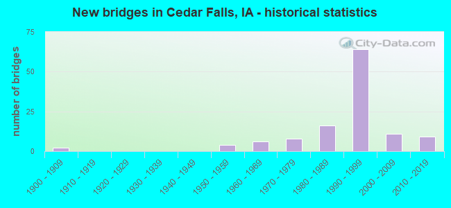
- New bridges - historical statistics
- 21900-1909
- 41950-1959
- 61960-1969
- 81970-1979
- 161980-1989
- 641990-1999
- 112000-2009
- 92010-2019
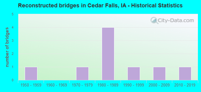
- Reconstructed bridges - Historical Statistics
- 11950-1959
- 01960-1969
- 11970-1979
- 41980-1989
- 11990-1999
- 12000-2009
- 12010-2019
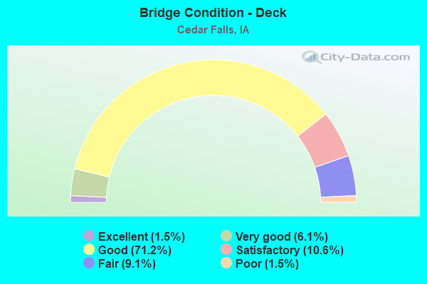
- Bridge Condition - Deck
- 1.5%Excellent
- 6.1%Very good
- 71.2%Good
- 10.6%Satisfactory
- 9.1%Fair
- 1.5%Poor
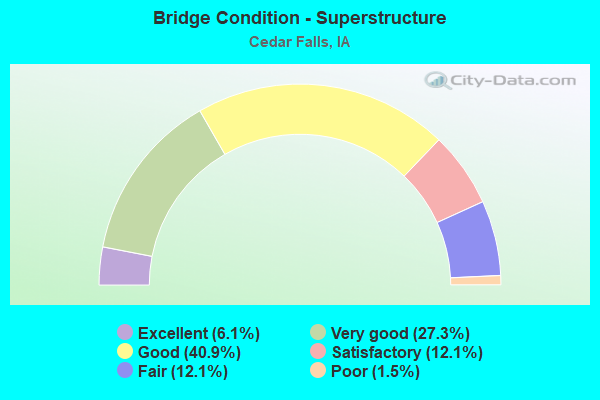
- Bridge Condition - Superstructure
- 6.1%Excellent
- 27.3%Very good
- 40.9%Good
- 12.1%Satisfactory
- 12.1%Fair
- 1.5%Poor
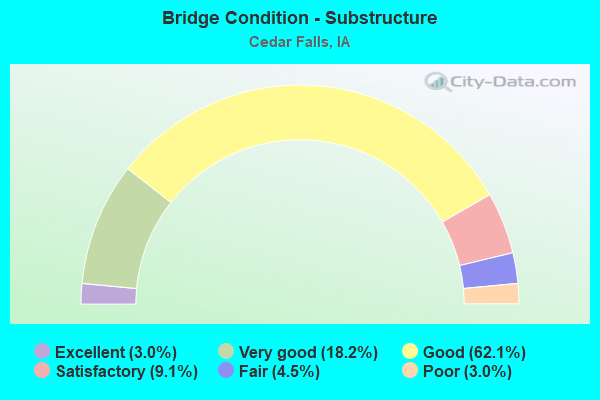
- Bridge Condition - Substructure
- 3.0%Excellent
- 18.2%Very good
- 62.1%Good
- 9.1%Satisfactory
- 4.5%Fair
- 3.0%Poor
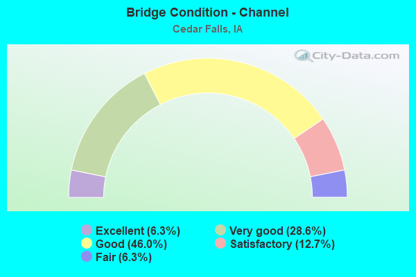
- Bridge Condition - Channel
- 6.3%Excellent
- 28.6%Very good
- 46.0%Good
- 12.7%Satisfactory
- 6.3%Fair
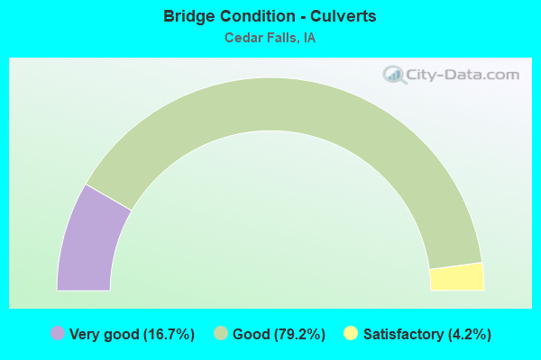
- Bridge Condition - Culverts
- 16.7%Very good
- 79.2%Good
- 4.2%Satisfactory
Find on map >> Show street view
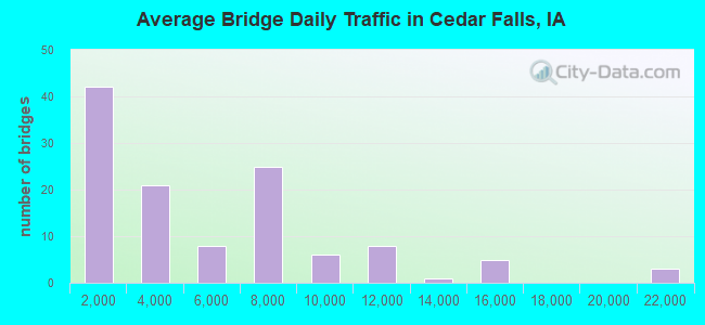
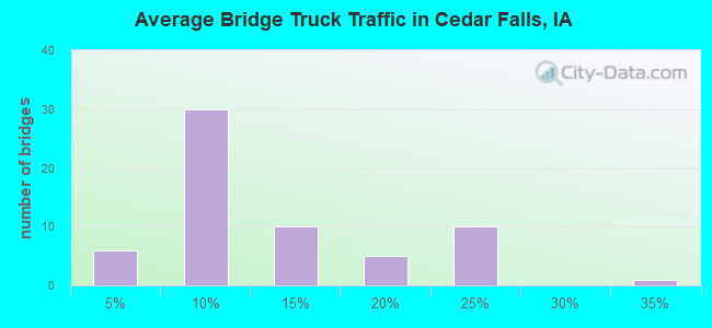
Structure Number: 605645, Location: At the Jct. Iowa #27 & 58 (Lat: 42.464681, Lng: -92.444092), Route carried "on" structure: US 20, Year Built: 1984, Status: Open, Structure Length: 5.67m (18.60ft), Average Daily Traffic: 6,550 (year 2020), Truck Traffic: 18%, Average Future Daily Traffic: 6,550 (year 2041), Design Load: HS 20, Features Intersected: IA 58
Minimum Vertical Clearance: 30+ m (98+ ft), Kilometerpoint: 152.390, Lanes on structure: 2, Lanes under structure: 4, Owner: State Highway Agency, Approaching Roadway Width: 12.2m (40.0ft), Skew: 2 degrees, Material/Design: Prestressed concrete, Design/Construction: Stringer/Multi-beam, Number Of Spans In Main Unit: 3, Length of Maximum Span: 28.0m (91.9ft), Curb-To-Curb Width: 12.2m (40.0ft), Out-to-Out Width: 13.2m (43.3ft)
Condition: Deck: Satisfactory, Superstructure: Fair, Substructure: Good, Operating Rating: 83.7 metric tons, Method Used To Determine Operating Rating: Load Factor (LF), Inventory Rating: 32.7 metric tons, Method Used To Determine Inventory Rating: Load Factor (LF), Structural Evaluation: Somewhat better than minimum adequacy, Deck Geometry: Better than present minimum criteria, Underclear: Meets minimum limits, Approach Roadway Alignment: Equal to present desirable criteria, Designated Inspection Frequency: Every 24 months, Inspection Date: Febuary 2021, Deck Structure Type: Concrete Cast-file-Place, Wearing Surface/Protective System: Wearing Surface: Monolithic Concrete, Deck Protection: Epoxy Coated Reinforcing
Find on map >> Show street view
Structure Number: 60696, Location: AT JUNCTION SR D18 (Lat: 42.463819, Lng: -92.533794), Route carried "on" structure: US 20, Year Built: 2000, Status: Open, Structure Length: 5.00m (16.40ft), Average Daily Traffic: 6,000 (year 2020), Truck Traffic: 21%, Average Future Daily Traffic: 6,000 (year 2040), Design Load: HS 20, Features Intersected: GRUNDY RD
Minimum Vertical Clearance: 30+ m (98+ ft), Kilometerpoint: 159.776, Lanes on structure: 2, Lanes under structure: 2, Owner: State Highway Agency, Approaching Roadway Width: 12.2m (40.0ft), Material/Design: Prestressed concrete, Design/Construction: Stringer/Multi-beam, Number Of Spans In Main Unit: 3, Length of Maximum Span: 20.4m (66.9ft), Curb-To-Curb Width: 12.0m (39.4ft), Out-to-Out Width: 13.0m (42.7ft)
Condition: Deck: Very good, Superstructure: Excellent, Substructure: Very good, Operating Rating: 62.1 metric tons, Method Used To Determine Operating Rating: Load Factor (LF), Inventory Rating: 37.3 metric tons, Method Used To Determine Inventory Rating: Load Factor (LF), Structural Evaluation: Equal to present desirable criteria, Deck Geometry: Better than present minimum criteria, Underclear: Superior to present desirable criteria, Approach Roadway Alignment: Better than present minimum criteria, Designated Inspection Frequency: Every 24 months, Inspection Date: August 2020, Deck Structure Type: Concrete Cast-file-Place, Wearing Surface/Protective System: Wearing Surface: Monolithic Concrete, Deck Protection: Epoxy Coated Reinforcing
Find on map >> Show street view
Structure Number: 606965, Location: AT JUNCTION WITH SR D18 (Lat: 42.463553, Lng: -92.534381), Route carried "on" structure: US 20, Year Built: 2000, Status: Open, Structure Length: 5.00m (16.40ft), Average Daily Traffic: 6,000 (year 2020), Truck Traffic: 21%, Average Future Daily Traffic: 6,000 (year 2040), Design Load: HS 20, Features Intersected: GRUNDY RD
Minimum Vertical Clearance: 30+ m (98+ ft), Kilometerpoint: 323.364, Lanes on structure: 2, Lanes under structure: 2, Base Highway Network: Yes, Owner: State Highway Agency, Approaching Roadway Width: 12.2m (40.0ft), Material/Design: Prestressed concrete, Design/Construction: Stringer/Multi-beam, Number Of Spans In Main Unit: 3, Length of Maximum Span: 20.4m (66.9ft), Curb-To-Curb Width: 12.0m (39.4ft), Out-to-Out Width: 13.0m (42.7ft)
Condition: Deck: Good, Superstructure: Excellent, Substructure: Very good, Operating Rating: 62.1 metric tons, Method Used To Determine Operating Rating: Load Factor (LF), Inventory Rating: 37.3 metric tons, Method Used To Determine Inventory Rating: Load Factor (LF), Structural Evaluation: Equal to present desirable criteria, Deck Geometry: Better than present minimum criteria, Underclear: Superior to present desirable criteria, Approach Roadway Alignment: Better than present minimum criteria, Designated Inspection Frequency: Every 24 months, Inspection Date: August 2020, Deck Structure Type: Concrete Cast-file-Place, Wearing Surface/Protective System: Wearing Surface: Monolithic Concrete, Deck Protection: Epoxy Coated Reinforcing
Find on map >> Show street view
Structure Number: 60759, Location: 1.2 MI. S OF JCT. US 218 (Lat: 42.526075, Lng: -92.436997), Route carried "on" structure: Ramp State highway 27, Year Built: 1992, Status: Open, Structure Length: 16.89m (55.41ft), Average Daily Traffic: 2,760 (year 2020), Truck Traffic: 3%, Average Future Daily Traffic: 2,760 (year 2041), Design Load: HS 20, Features Intersected: DRY RUN CREEK & CEDAR RV
Minimum Vertical Clearance: 30+ m (98+ ft), Kilometerpoint: 0.208, Lanes on structure: 2, Owner: State Highway Agency, Approaching Roadway Width: 11.0m (36.1ft), Material/Design: Prestressed concrete, Design/Construction: Stringer/Multi-beam, Number Of Spans In Main Unit: 5, Length of Maximum Span: 32.3m (106.0ft), Curb-To-Curb Width: 11.0m (36.1ft), Out-to-Out Width: 11.9m (39.0ft)
Condition: Deck: Good, Superstructure: Very good, Substructure: Good, Channel: Good, Operating Rating: 88.5 metric tons, Method Used To Determine Operating Rating: Load Factor (LF), Inventory Rating: 43.7 metric tons, Method Used To Determine Inventory Rating: Load Factor (LF), Structural Evaluation: Better than present minimum criteria, Deck Geometry: Better than present minimum criteria, Waterway Adequacy: Equal to present desirable criteria, Approach Roadway Alignment: Equal to present desirable criteria, Designated Inspection Frequency: Every 24 months, Inspection Date: July 2021, Deck Structure Type: Concrete Cast-file-Place, Wearing Surface/Protective System: Wearing Surface: Monolithic Concrete, Deck Protection: Epoxy Coated Reinforcing
Find on map >> Show street view
Structure Number: 607595, Location: 1.3 MI.S.OF JCT.US 218 (Lat: 42.525125, Lng: -92.437992), Route carried "on" structure: Ramp State highway 27, Year Built: 1992, Status: Open, Structure Length: 14.72m (48.29ft), Average Daily Traffic: 2,900 (year 2020), Truck Traffic: 3%, Average Future Daily Traffic: 2,900 (year 2041), Design Load: HS 20+Mod, Features Intersected: DRY RUN CREEK & BIKE PAT
Minimum Vertical Clearance: 30+ m (98+ ft), Kilometerpoint: 0.206, Lanes on structure: 2, Owner: State Highway Agency, Approaching Roadway Width: 12.2m (40.0ft), Material/Design: Prestressed concrete, Design/Construction: Stringer/Multi-beam, Number Of Spans In Main Unit: 5, Length of Maximum Span: 31.1m (102.0ft), Curb-To-Curb Width: 11.0m (36.1ft), Out-to-Out Width: 11.9m (39.0ft)
Condition: Deck: Good, Superstructure: Very good, Substructure: Good, Channel: Good, Operating Rating: 88.0 metric tons, Method Used To Determine Operating Rating: Load Factor (LF), Inventory Rating: 50.4 metric tons, Method Used To Determine Inventory Rating: Load Factor (LF), Structural Evaluation: Better than present minimum criteria, Deck Geometry: Better than present minimum criteria, Waterway Adequacy: Equal to present desirable criteria, Approach Roadway Alignment: Equal to present minimum criteria, Designated Inspection Frequency: Every 24 months, Inspection Date: July 2021, Deck Structure Type: Concrete Cast-file-Place, Wearing Surface/Protective System: Wearing Surface: Monolithic Concrete, Deck Protection: Epoxy Coated Reinforcing
Find on map >> Show street view
Structure Number: 69975, Location: 0.3 mi. S of Univ. Ave. (Lat: 42.507389, Lng: -92.456567), Route carried "on" structure: State lands road , Year Built: 1978, Status: Open, Structure Length: 5.46m (17.91ft), Design Load: H 20, Features Intersected: DRY RUN CREEK (UNI), Facility Carried by Structure: JENNINGS DR
Minimum Vertical Clearance: 30+ m (98+ ft), Kilometerpoint: 1.566, Lanes on structure: 2, Owner: State Highway Agency, Approaching Roadway Width: 7.3m (24.0ft), Material/Design: Prestressed concrete, Design/Construction: Stringer/Multi-beam, Number Of Spans In Main Unit: 3, Length of Maximum Span: 19.2m (63.0ft), Curb or Sidewalk Widths: Left: 0.0m, Right: 1.8m (5.9ft), Curb-To-Curb Width: 9.1m (29.9ft), Out-to-Out Width: 11.8m (38.7ft)
Condition: Deck: Good, Superstructure: Good, Substructure: Good, Channel: Good, Operating Rating: 65.3 metric tons, Method Used To Determine Operating Rating: Load Factor (LF), Inventory Rating: 39.0 metric tons, Method Used To Determine Inventory Rating: Load Factor (LF), Structural Evaluation: Better than present minimum criteria, Deck Geometry: Better than present minimum criteria, Waterway Adequacy: Better than present minimum criteria, Approach Roadway Alignment: Equal to present minimum criteria, Designated Inspection Frequency: Every 24 months, Inspection Date: April 2021, Deck Structure Type: Concrete Cast-file-Place, Wearing Surface/Protective System: Wearing Surface: Monolithic Concrete
Find on map >> Show street view
Structure Number: 70088, Location: 4.2 M S of Jct US 218 (Lat: 42.484036, Lng: -92.446144), Route carried "on" structure: City street , Year Built: 2019, Status: Open, Structure Length: 3.60m (11.81ft), Average Daily Traffic: 14,600 (year 2021), Average Future Daily Traffic: 14,600 (year 2040), Design Load: HL 93, Features Intersected: IA 27 & 58, Facility Carried by Structure: VIKING ROAD
Minimum Vertical Clearance: 30+ m (98+ ft), Kilometerpoint: 2.903, Lanes on structure: 6, Lanes under structure: 4, Owner: State Highway Agency, Approaching Roadway Width: 26.8m (87.9ft), Material/Design: Prestressed concrete, Design/Construction: Stringer/Multi-beam, Number Of Spans In Main Unit: 1, Length of Maximum Span: 35.1m (115.2ft), Curb-To-Curb Width: 26.8m (87.9ft), Out-to-Out Width: 69.5m (228.0ft)
Condition: Deck: Excellent, Superstructure: Excellent, Substructure: Excellent, Operating Rating: 42.1 metric tons, Method Used To Determine Operating Rating: Load and Resistance Factor Rating (LRFR) rating reported by rating factor(RF) method using HL-93 loadings, Inventory Rating: 32.4 metric tons, Method Used To Determine Inventory Rating: Load and Resistance Factor Rating (LRFR) rating reported by rating factor(RF) method using HL-93 loadings, Structural Evaluation: Equal to present desirable criteria, Deck Geometry: Better than present minimum criteria, Underclear: Superior to present desirable criteria, Approach Roadway Alignment: Equal to present desirable criteria, Designated Inspection Frequency: Every 24 months, Inspection Date: May 2020, Deck Structure Type: Concrete Cast-file-Place, Wearing Surface/Protective System: Wearing Surface: Monolithic Concrete, Deck Protection: Epoxy Coated Reinforcing
Find on map >> Show street view
Structure Number: 601245, Location: AT JCT. IA 57 & US 218 (Lat: 42.537075, Lng: -92.425947), Route carried "under" structure: Ramp State highway 27, Year Built: 1994, Structure Length: 0. m, Average Daily Traffic: 500 (year 2020), Truck Traffic: 9%, Features Intersected: IA 57
Minimum Vertical Clearance: 30+ m (98+ ft), Kilometerpoint: 0.533, Lanes on structure: 3, Lanes under structure: 7, Material/Design: Prestressed concrete, Design/Construction: Stringer/Multi-beam, Length of Maximum Span: 30.8m (101.0ft)
Find on map >> Show street view
Structure Number: 601245, Location: AT JCT. IA 57 & US 218 (Lat: 42.537075, Lng: -92.425947), Route carried "under" structure: US 218, Year Built: 1994, Structure Length: 0. m, Average Daily Traffic: 2,345 (year 2020), Truck Traffic: 22%, Features Intersected: IA 57, Facility Carried by Structure: NB IA 27
Minimum Vertical Clearance: 30+ m (98+ ft), Kilometerpoint: 138.985, Lanes on structure: 3, Lanes under structure: 7, Material/Design: Prestressed concrete, Design/Construction: Stringer/Multi-beam, Length of Maximum Span: 30.8m (101.0ft)
Find on map >> Show street view
Structure Number: 601245, Location: AT JCT. IA 57 & US 218 (Lat: 42.537075, Lng: -92.425947), Route carried "under" structure: Ramp State highway 27, Year Built: 1994, Structure Length: 0. m, Average Daily Traffic: 405 (year 2020), Truck Traffic: 5%, Features Intersected: IA 57
Minimum Vertical Clearance: 30+ m (98+ ft), Kilometerpoint: 0.003, Lanes on structure: 3, Lanes under structure: 7, Material/Design: Prestressed concrete, Design/Construction: Stringer/Multi-beam, Length of Maximum Span: 30.8m (101.0ft)
Find on map >> Show street view
Structure Number: 60125, Location: AT JCT. IA. 57 & US 218 (Lat: 42.537922, Lng: -92.425950), Route carried "under" structure: State highway 57, Year Built: 1994, Structure Length: 0. m, Average Daily Traffic: 6,800 (year 2020), Truck Traffic: 1%, Features Intersected: IA 57, Facility Carried by Structure: IA 27 SB
Minimum Vertical Clearance: 30+ m (98+ ft), Kilometerpoint: 70.410, Lanes on structure: 3, Lanes under structure: 7, Material/Design: Prestressed concrete, Design/Construction: Stringer/Multi-beam, Length of Maximum Span: 30.8m (101.0ft)
Find on map >> Show street view
Structure Number: 60125, Location: AT JCT. IA. 57 & US 218 (Lat: 42.537922, Lng: -92.425950), Route carried "under" structure: Ramp State highway 27, Year Built: 1994, Structure Length: 0. m, Average Daily Traffic: 500 (year 2020), Truck Traffic: 9%, Features Intersected: IA 57
Minimum Vertical Clearance: 30+ m (98+ ft), Kilometerpoint: 0.552, Lanes on structure: 3, Lanes under structure: 7, Material/Design: Prestressed concrete, Design/Construction: Stringer/Multi-beam, Length of Maximum Span: 30.8m (101.0ft)
Find on map >> Show street view
Structure Number: 60125, Location: AT JCT. IA. 57 & US 218 (Lat: 42.537922, Lng: -92.425950), Route carried "under" structure: Ramp US 218, Year Built: 1994, Structure Length: 0. m, Average Daily Traffic: 2,255 (year 2020), Truck Traffic: 18%, Features Intersected: IA 57, Facility Carried by Structure: IA 27 SB
Minimum Vertical Clearance: 30+ m (98+ ft), Kilometerpoint: 138.962, Lanes on structure: 3, Lanes under structure: 7, Material/Design: Prestressed concrete, Design/Construction: Stringer/Multi-beam, Length of Maximum Span: 30.8m (101.0ft)
Find on map >> Show street view
Structure Number: 60126, Location: .3 mi S of University Ave (Lat: 42.508961, Lng: -92.446128), Route carried "under" structure: City street , Year Built: 1993, Structure Length: 0. m, Average Daily Traffic: 3,150 (year 2014), Features Intersected: SO MAIN ST, Facility Carried by Structure: NB IA 27
Minimum Vertical Clearance: 30+ m (98+ ft), Kilometerpoint: 2.441, Lanes on structure: 3, Lanes under structure: 2, Material/Design: Steel continuous, Design/Construction: Stringer/Multi-beam, Length of Maximum Span: 30.2m (99.1ft)
Find on map >> Show street view
Structure Number: 601265, Location: .3 mi S of University Ave (Lat: 42.509617, Lng: -92.445428), Route carried "under" structure: City street , Year Built: 1993, Structure Length: 0. m, Average Daily Traffic: 3,150 (year 2014), Features Intersected: SO MAIN ST, Facility Carried by Structure: SB IA 27
Minimum Vertical Clearance: 30+ m (98+ ft), Kilometerpoint: 2.461, Lanes on structure: 3, Lanes under structure: 2, Material/Design: Steel continuous, Design/Construction: Stringer/Multi-beam, Length of Maximum Span: 30.2m (99.1ft)
Find on map >> Show street view
Structure Number: 601275, Location: 2.1 MI. S of U.S. 218 (Lat: 42.512678, Lng: -92.443275), Route carried "under" structure: City street , Year Built: 1993, Structure Length: 0. m, Average Daily Traffic: 8,200 (year 2021), Features Intersected: UNIVERSITY AVE, Facility Carried by Structure: IA 27
Minimum Vertical Clearance: 30+ m (98+ ft), Kilometerpoint: 5.275, Lanes on structure: 4, Lanes under structure: 7, Material/Design: Steel continuous, Design/Construction: Stringer/Multi-beam, Length of Maximum Span: 42.7m (140.1ft)
Find on map >> Show street view
Structure Number: 60147, Location: 0.2 mi N of University Av (Lat: 42.515519, Lng: -92.442869), Route carried "under" structure: City street , Year Built: 1994, Structure Length: 0. m, Average Daily Traffic: 1,175 (year 2021), Features Intersected: SEERLEY BLVD, Facility Carried by Structure: NB IA 27
Minimum Vertical Clearance: 30+ m (98+ ft), Kilometerpoint: 0.241, Lanes on structure: 3, Lanes under structure: 2, Material/Design: Prestressed concrete, Design/Construction: Stringer/Multi-beam, Length of Maximum Span: 18.6m (61.0ft)
Find on map >> Show street view
Structure Number: 601475, Location: 0.2 mi N of University Av (Lat: 42.516028, Lng: -92.442956), Route carried "under" structure: City street , Year Built: 1994, Structure Length: 0. m, Average Daily Traffic: 1,175 (year 2021), Features Intersected: SEERLEY BLVD, Facility Carried by Structure: SB IA 27
Minimum Vertical Clearance: 30+ m (98+ ft), Kilometerpoint: 0.212, Lanes on structure: 3, Lanes under structure: 2, Material/Design: Prestressed concrete, Design/Construction: Stringer/Multi-beam, Length of Maximum Span: 18.6m (61.0ft)
Find on map >> Show street view
Structure Number: 60149, Location: 1.6 mi. S of US 218 (Lat: 42.521506, Lng: -92.441936), Route carried "under" structure: City street , Year Built: 1994, Structure Length: 0. m, Average Daily Traffic: 1,645 (year 2021), Features Intersected: 18TH ST, Facility Carried by Structure: NB IA 27
Minimum Vertical Clearance: 30+ m (98+ ft), Kilometerpoint: 1.957, Lanes on structure: 2, Lanes under structure: 5, Material/Design: Prestressed concrete, Design/Construction: Stringer/Multi-beam, Length of Maximum Span: 32.3m (106.0ft)
Find on map >> Show street view
Structure Number: 601495, Location: 1.6 Mi. S of US 218 (Lat: 42.522100, Lng: -92.441867), Route carried "under" structure: City street , Year Built: 1994, Structure Length: 0. m, Average Daily Traffic: 1,645 (year 2021), Features Intersected: 18TH ST, Facility Carried by Structure: SB IA 27
Minimum Vertical Clearance: 30+ m (98+ ft), Kilometerpoint: 1.941, Lanes on structure: 2, Lanes under structure: 4, Material/Design: Prestressed concrete, Design/Construction: Stringer/Multi-beam, Length of Maximum Span: 32.3m (106.0ft)
Find on map >> Show street view
Structure Number: 601525, Location: 1.3 mi. S of Jct. US 218 (Lat: 42.523917, Lng: -92.440378), Route carried "under" structure: City street , Year Built: 1995, Structure Length: 0. m, Average Daily Traffic: 2,500 (year 2021), Features Intersected: WATERLOO RD, Facility Carried by Structure: NB IA 27
Minimum Vertical Clearance: 30+ m (98+ ft), Kilometerpoint: 1.682, Lanes on structure: 2, Lanes under structure: 5, Material/Design: Prestressed concrete, Design/Construction: Stringer/Multi-beam, Length of Maximum Span: 32.3m (106.0ft)
Find on map >> Show street view
Structure Number: 60153, Location: 1.3 mi. S of Jct. US 218 (Lat: 42.524431, Lng: -92.439964), Route carried "under" structure: City street , Year Built: 1995, Structure Length: 0. m, Average Daily Traffic: 2,500 (year 2021), Features Intersected: WATERLOO RD, Facility Carried by Structure: SB IA 27
Minimum Vertical Clearance: 30+ m (98+ ft), Kilometerpoint: 1.693, Lanes on structure: 2, Lanes under structure: 5, Material/Design: Prestressed concrete, Design/Construction: Stringer/Multi-beam, Length of Maximum Span: 32.3m (106.0ft)
Find on map >> Show street view
Structure Number: 601555, Location: AT JCT. OF IA #57 (Lat: 42.537822, Lng: -92.428722), Route carried "under" structure: State highway 57, Year Built: 1995, Structure Length: 0. m, Average Daily Traffic: 14,600 (year 2020), Truck Traffic: 2%, Features Intersected: IA 57, Facility Carried by Structure: RAMP J (SB)
Minimum Vertical Clearance: 30+ m (98+ ft), Kilometerpoint: 70.190, Lanes on structure: 2, Lanes under structure: 4, Material/Design: Prestressed concrete, Design/Construction: Stringer/Multi-beam, Length of Maximum Span: 30.8m (101.0ft)
Find on map >> Show street view
Structure Number: 60156, Location: 0.1 MI. N OF JCT. IA. #57 (Lat: 42.539531, Lng: -92.425081), Route carried "under" structure: US 218, Year Built: 1995, Structure Length: 0. m, Average Daily Traffic: 4,690 (year 2020), Truck Traffic: 22%, Features Intersected: IA 58
Minimum Vertical Clearance: 30+ m (98+ ft), Kilometerpoint: 138.190, Lanes on structure: 2, Lanes under structure: 4, Material/Design: Prestressed concrete, Design/Construction: Stringer/Multi-beam, Length of Maximum Span: 21.0m (68.9ft)
Find on map >> Show street view
Structure Number: 601565, Location: 0.3 mi. N of jct. IA 57 (Lat: 42.540564, Lng: -92.425219), Route carried "under" structure: City street , Year Built: 1995, Structure Length: 0. m, Average Daily Traffic: 1,200 (year 2017), Features Intersected: LINCOLN ST & OVERFLO, Facility Carried by Structure: NB US 218
Minimum Vertical Clearance: 30+ m (98+ ft), Kilometerpoint: 1.667, Lanes on structure: 2, Lanes under structure: 2, Material/Design: Prestressed concrete, Design/Construction: Stringer/Multi-beam, Length of Maximum Span: 32.6m (107.0ft)
Find on map >> Show street view
Structure Number: 60157, Location: 0.3 Mi. N of Jct. IA 57 (Lat: 42.542292, Lng: -92.425031), Route carried "under" structure: City street , Year Built: 1995, Structure Length: 0. m, Average Daily Traffic: 1,200 (year 2017), Features Intersected: LINCOLN ST & OVERFLO, Facility Carried by Structure: SB US 218
Minimum Vertical Clearance: 30+ m (98+ ft), Kilometerpoint: 1.650, Lanes on structure: 2, Lanes under structure: 2, Material/Design: Prestressed concrete, Design/Construction: Stringer/Multi-beam, Length of Maximum Span: 32.6m (107.0ft)
Find on map >> Show street view
Structure Number: 601575, Location: 0.1 MI. N OF JCT. IA #57 (Lat: 42.542350, Lng: -92.425169), Route carried "under" structure: City street , Year Built: 1995, Structure Length: 0. m, Average Daily Traffic: 2,400 (year 2017), Features Intersected: LINCOLN ST & OVERFLO, Facility Carried by Structure: RAMP A (SB)
Minimum Vertical Clearance: 30+ m (98+ ft), Kilometerpoint: 1.637, Lanes on structure: 1, Lanes under structure: 2, Material/Design: Prestressed concrete, Design/Construction: Stringer/Multi-beam, Length of Maximum Span: 32.6m (107.0ft)
Find on map >> Show street view
Structure Number: 6016, Location: 1.7 mi N of IA 57 & IA 58 (Lat: 42.561236, Lng: -92.426456), Route carried "under" structure: US 218, Year Built: 1995, Structure Length: 0. m, Average Daily Traffic: 20,800 (year 2020), Truck Traffic: 13%, Features Intersected: US 218, Facility Carried by Structure: LONE TREE RD
Minimum Vertical Clearance: 30+ m (98+ ft), Kilometerpoint: 302.941, Lanes on structure: 2, Lanes under structure: 4, Material/Design: Steel continuous, Design/Construction: Stringer/Multi-beam, Length of Maximum Span: 34.7m (113.8ft)
Find on map >> Show street view
Structure Number: 601605, Location: At Jct. Dunkerton Rd. (Lat: 42.570811, Lng: -92.428447), Route carried "under" structure: US 218, Year Built: 1995, Structure Length: 0. m, Average Daily Traffic: 21,300 (year 2020), Truck Traffic: 13%, Features Intersected: US 218, Facility Carried by Structure: DUNKERTON RD
Minimum Vertical Clearance: 30+ m (98+ ft), Kilometerpoint: 304.034, Lanes on structure: 2, Lanes under structure: 4, Material/Design: Steel continuous, Design/Construction: Stringer/Multi-beam, Length of Maximum Span: 34.1m (111.9ft)
Find on map >> Show street view
Structure Number: 60563, Location: At jct. U.S. 20 (Lat: 42.465269, Lng: -92.465700), Route carried "under" structure: US 20, Year Built: 1984, Structure Length: 0. m, Average Daily Traffic: 5,600 (year 2020), Truck Traffic: 21%, Features Intersected: US 20, Facility Carried by Structure: SB IA 58
Minimum Vertical Clearance: 30+ m (98+ ft), Kilometerpoint: 329.011, Lanes on structure: 2, Lanes under structure: 4, Material/Design: Prestressed concrete, Design/Construction: Stringer/Multi-beam, Length of Maximum Span: 29.6m (97.1ft)
Find on map >> Show street view
Structure Number: 60563, Location: At jct. U.S. 20 (Lat: 42.465269, Lng: -92.465700), Route carried "under" structure: Ramp US 20, Year Built: 1984, Structure Length: 0. m, Average Daily Traffic: 940 (year 2020), Truck Traffic: 8%, Features Intersected: US 20, Facility Carried by Structure: SB IA 58
Minimum Vertical Clearance: 30+ m (98+ ft), Kilometerpoint: 0.566, Lanes on structure: 2, Lanes under structure: 4, Material/Design: Prestressed concrete, Design/Construction: Stringer/Multi-beam, Length of Maximum Span: 29.6m (97.1ft)
Find on map >> Show street view
Structure Number: 605635, Location: At the Jct. U.S. 20 (Lat: 42.464522, Lng: -92.465533), Route carried "under" structure: US 20, Year Built: 1984, Structure Length: 0. m, Average Daily Traffic: 5,600 (year 2020), Truck Traffic: 21%, Features Intersected: U.S. 20, Facility Carried by Structure: NB IA 58
Minimum Vertical Clearance: 30+ m (98+ ft), Kilometerpoint: 329.027, Lanes on structure: 2, Lanes under structure: 5, Material/Design: Prestressed concrete, Design/Construction: Stringer/Multi-beam, Length of Maximum Span: 29.3m (96.1ft)
Find on map >> Show street view
Structure Number: 60564, Location: At the Jct. Iowa #27 & 58 (Lat: 42.464442, Lng: -92.444553), Route carried "under" structure: State highway 58, Year Built: 1984, Structure Length: 0. m, Average Daily Traffic: 720 (year 2020), Truck Traffic: 11%, Features Intersected: IA 58, Facility Carried by Structure: US 20 EB
Minimum Vertical Clearance: 30+ m (98+ ft), Kilometerpoint: 9.695, Lanes on structure: 2, Lanes under structure: 4, Material/Design: Prestressed concrete, Design/Construction: Stringer/Multi-beam, Length of Maximum Span: 28.0m (91.9ft)
Find on map >> Show street view
Structure Number: 605645, Location: At the Jct. Iowa #27 & 58 (Lat: 42.464681, Lng: -92.444092), Route carried "under" structure: State highway 58, Year Built: 1984, Structure Length: 0. m, Average Daily Traffic: 720 (year 2020), Truck Traffic: 11%, Features Intersected: IA 58, Facility Carried by Structure: WB US 20
Minimum Vertical Clearance: 30+ m (98+ ft), Kilometerpoint: 9.725, Lanes on structure: 2, Lanes under structure: 4, Material/Design: Prestressed concrete, Design/Construction: Stringer/Multi-beam, Length of Maximum Span: 28.0m (91.9ft)
Find on map >> Show street view
Structure Number: 60696, Location: AT JUNCTION SR D18 (Lat: 42.463819, Lng: -92.533794), Route carried "under" structure: County highway , Year Built: 2000, Structure Length: 0. m, Average Daily Traffic: 535 (year 2021), Features Intersected: GRUNDY RD, Facility Carried by Structure: US 20 WB
Minimum Vertical Clearance: 30+ m (98+ ft), Kilometerpoint: 18.512, Lanes on structure: 2, Lanes under structure: 2, Material/Design: Prestressed concrete, Design/Construction: Stringer/Multi-beam, Length of Maximum Span: 20.4m (66.9ft)
Find on map >> Show street view
Structure Number: 606965, Location: AT JUNCTION WITH SR D18 (Lat: 42.463553, Lng: -92.534381), Route carried "under" structure: County highway , Year Built: 2000, Structure Length: 0. m, Average Daily Traffic: 535 (year 2021), Features Intersected: GRUNDY RD, Facility Carried by Structure: US 20 EB
Minimum Vertical Clearance: 30+ m (98+ ft), Kilometerpoint: 18.485, Lanes on structure: 2, Lanes under structure: 2, Material/Design: Prestressed concrete, Design/Construction: Stringer/Multi-beam, Length of Maximum Span: 20.4m (66.9ft)
Find on map >> Show street view
Structure Number: 70088, Location: 4.2 M S of Jct US 218 (Lat: 42.484036, Lng: -92.446144), Route carried "under" structure: State highway 27, Year Built: 2019, Structure Length: 0. m, Average Daily Traffic: 10,000 (year 2020), Truck Traffic: 8%, Features Intersected: IA 27 & 58, Facility Carried by Structure: VIKING ROAD
Minimum Vertical Clearance: 30+ m (98+ ft), Kilometerpoint: 271.395, Lanes on structure: 6, Lanes under structure: 4, Material/Design: Prestressed concrete, Design/Construction: Stringer/Multi-beam, Length of Maximum Span: 35.1m (115.2ft)