Bridge Statistics for Clanton, Alabama (AL)
Condition, Traffic, Stress, Structural Evaluation, Project Costs
- National Bridge Inventory (NBI) Statistics
- 92Number of bridges
- 1,030ft / 314mTotal length
- $108,514,000Total costs
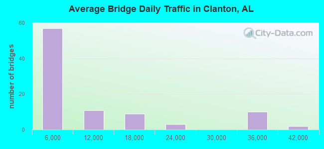
- 765,151Total average daily traffic
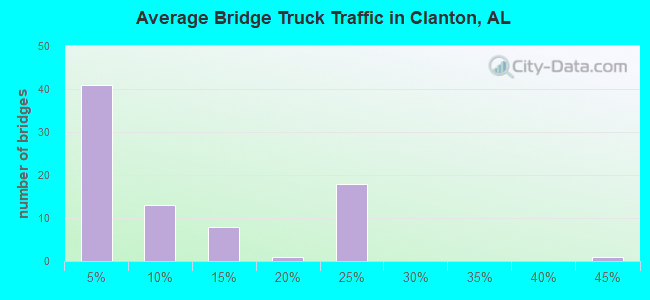
- 139,430Total average daily truck traffic
- National Bridge Inventory (NBI) Registered Bridges for Clanton
- No street view available for this location
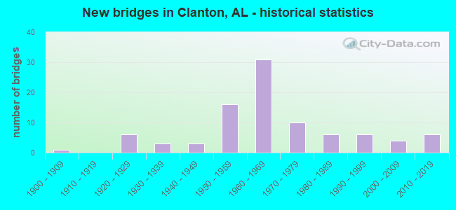
- New bridges - historical statistics
- 11900-1909
- 61920-1929
- 31930-1939
- 31940-1949
- 161950-1959
- 311960-1969
- 101970-1979
- 61980-1989
- 61990-1999
- 42000-2009
- 62010-2019
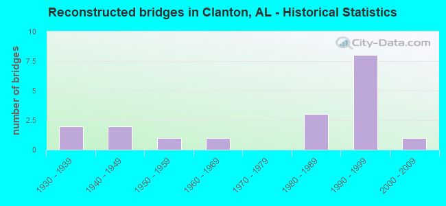
- Reconstructed bridges - Historical Statistics
- 21930-1939
- 21940-1949
- 11950-1959
- 11960-1969
- 01970-1979
- 31980-1989
- 81990-1999
- 12000-2009
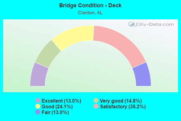
- Bridge Condition - Deck
- 13.0%Excellent
- 14.8%Very good
- 24.1%Good
- 35.2%Satisfactory
- 13.0%Fair
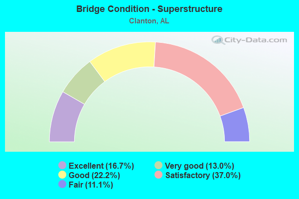
- Bridge Condition - Superstructure
- 16.7%Excellent
- 13.0%Very good
- 22.2%Good
- 37.0%Satisfactory
- 11.1%Fair
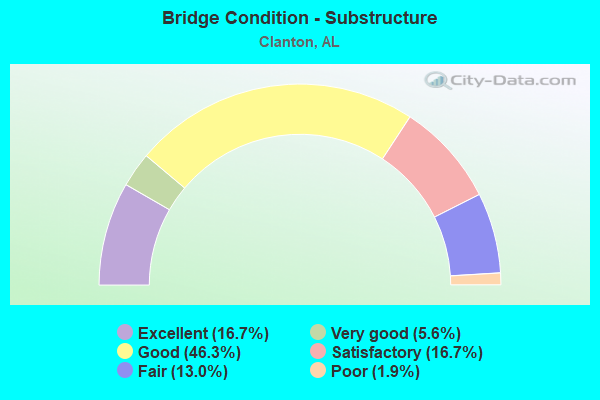
- Bridge Condition - Substructure
- 16.7%Excellent
- 5.6%Very good
- 46.3%Good
- 16.7%Satisfactory
- 13.0%Fair
- 1.9%Poor
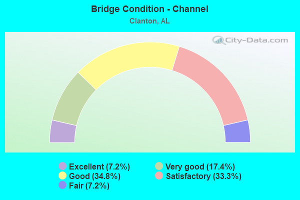
- Bridge Condition - Channel
- 7.2%Excellent
- 17.4%Very good
- 34.8%Good
- 33.3%Satisfactory
- 7.2%Fair
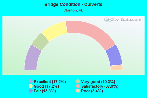
- Bridge Condition - Culverts
- 17.2%Excellent
- 10.3%Very good
- 17.2%Good
- 37.9%Satisfactory
- 13.8%Fair
- 3.4%Poor
Find on map >> Show street view
Structure Number: 9554, Location: .8 MI S AL 22 (Lat: 32.826361, Lng: -86.653194), Route carried "on" structure: City street , Year Built: 1968, Status: Open, Structure Length: 1.19m (3.90ft), Average Daily Traffic: 1,000 (year 2007), Truck Traffic: 1%, Average Future Daily Traffic: 1,400 (year 2041), Design Load: HS 20, Features Intersected: POLY CREEK, Facility Carried by Structure: HINKLE ROAD
Minimum Vertical Clearance: 30+ m (98+ ft), Kilometerpoint: 0.010, Lanes on structure: 2, Owner: City or Municipal Highway Agency, Approaching Roadway Width: 6.7m (22.0ft), Material/Design: Concrete, Design/Construction: Culvert, Number Of Spans In Main Unit: 3, Length of Maximum Span: 3.7m (12.1ft)
Condition: Channel: Fair, Culverts: Poor, Operating Rating: 33.5 metric tons, Method Used To Determine Operating Rating: Load Factor (LF), Inventory Rating: 20.1 metric tons, Method Used To Determine Inventory Rating: Load Factor (LF), Structural Evaluation: Meets minimum limits, Waterway Adequacy: Better than present minimum criteria, Approach Roadway Alignment: Better than present minimum criteria, Length Of Structure Improvement: 1.86m (6.10ft), Designated Inspection Frequency: Every 24 months, Other Special Inspection Frequency: Every 12 months, Inspection Date: March 2021, Other Special Inspection Date: March 2021, Bridge Improvement Cost: $387,000, Roadway Improvement Cost: $39,000, Total Project Cost: $426,000 ( Estimate for 2022)
Find on map >> Show street view
Structure Number: 9621, Location: 1 MI WEST BURBANK (Lat: 31.209631, Lng: -88.404564), Route carried "on" structure: County highway 8, Year Built: 1968, Status: Open, Structure Length: 0.79m (2.59ft), Average Daily Traffic: 160 (year 1992), Truck Traffic: 10%, Average Future Daily Traffic: 200 (year 2041), Design Load: HS 20, Features Intersected: GUM BRANCH
Minimum Vertical Clearance: 30+ m (98+ ft), Kilometerpoint: 0.010, Lanes on structure: 2, Owner: County Highway Agency, Approaching Roadway Width: 8.5m (27.9ft), Material/Design: Concrete, Design/Construction: Culvert, Number Of Spans In Main Unit: 3, Length of Maximum Span: 2.4m (7.9ft)
Condition: Channel: Good, Culverts: Satisfactory, Operating Rating: 35.7 metric tons, Method Used To Determine Operating Rating: Load Factor (LF), Inventory Rating: 21.5 metric tons, Method Used To Determine Inventory Rating: Load Factor (LF), Structural Evaluation: Equal to present minimum criteria, Waterway Adequacy: Equal to present desirable criteria, Approach Roadway Alignment: Equal to present desirable criteria, Length Of Structure Improvement: 1.45m (4.76ft), Designated Inspection Frequency: Every 24 months, Inspection Date: November 2021, Bridge Improvement Cost: $293,000, Roadway Improvement Cost: $29,000, Total Project Cost: $322,000 ( Estimate for 2022)
Find on map >> Show street view
Structure Number: 9712, Location: 0.1 M E JCT SR 36 & I 65 (Lat: 34.449106, Lng: -86.900025), Route carried "on" structure: State highway 36, Year Built: 1968, Status: Open, Structure Length: 1.31m (4.30ft), Average Daily Traffic: 11,780 (year 2021), Truck Traffic: 5%, Average Future Daily Traffic: 14,260 (year 2033), Design Load: H 20, Features Intersected: SHOALS CREEK
Minimum Vertical Clearance: 30+ m (98+ ft), Kilometerpoint: 37.803, Lanes on structure: 2, Base Highway Network: Yes, Owner: State Highway Agency, Approaching Roadway Width: 13.4m (44.0ft), Skew: 1 degrees, Material/Design: Concrete continuous, Design/Construction: Culvert, Number Of Spans In Main Unit: 4, Length of Maximum Span: 3.0m (9.8ft)
Condition: Channel: Satisfactory, Culverts: Satisfactory, Operating Rating: 88.9 metric tons, Method Used To Determine Operating Rating: Load Factor (LF), Inventory Rating: 88.9 metric tons, Method Used To Determine Inventory Rating: Load Factor (LF), Structural Evaluation: Equal to present minimum criteria, Waterway Adequacy: Equal to present minimum criteria, Approach Roadway Alignment: Equal to present desirable criteria, Length Of Structure Improvement: 1.98m (6.50ft), Designated Inspection Frequency: Every 24 months, Inspection Date: August 2021, Bridge Improvement Cost: $1,662,000, Roadway Improvement Cost: $166,000, Total Project Cost: $1,828,000 ( Estimate for 2022), Wearing Surface/Protective System: Wearing Surface: Bituminous
Find on map >> Show street view
Structure Number: 9715, Location: 1.6 MI E JCT 80 MI (Lat: 32.455506, Lng: -85.009947), Route carried "on" structure: US 280, Year Built: 1968, Status: Open, Structure Length: 7.53m (24.70ft), Average Daily Traffic: 16,690 (year 2009), Truck Traffic: 7%, Average Future Daily Traffic: 27,350 (year 2033), Design Load: HS 20, Features Intersected: US 431
Minimum Vertical Clearance: 30+ m (98+ ft), Kilometerpoint: 219.206, Lanes on structure: 2, Lanes under structure: 4, Base Highway Network: Yes, Owner: State Highway Agency, Approaching Roadway Width: 14.0m (45.9ft), Skew: 1 degrees, Material/Design: Concrete continuous, Design/Construction: Tee Beam, Number Of Spans In Main Unit: 4, Length of Maximum Span: 20.7m (67.9ft), Curb or Sidewalk Widths: Left: 0.4m (1.3ft), Right: 0.4m (1.3ft), Curb-To-Curb Width: 14.6m (47.9ft), Out-to-Out Width: 15.5m (50.9ft)
Condition: Deck: Fair, Superstructure: Satisfactory, Substructure: Good, Operating Rating: 48.4 metric tons, Method Used To Determine Operating Rating: Load Factor (LF), Inventory Rating: 28.5 metric tons, Method Used To Determine Inventory Rating: Load Factor (LF), Structural Evaluation: Equal to present minimum criteria, Deck Geometry: Superior to present desirable criteria, Underclear: Equal to present minimum criteria, Approach Roadway Alignment: Equal to present minimum criteria, Length Of Structure Improvement: 8.55m (28.05ft), Designated Inspection Frequency: Every 24 months, Inspection Date: July 2021, Bridge Improvement Cost: $2,931,000, Roadway Improvement Cost: $293,000, Total Project Cost: $3,224,000 ( Estimate for 2022), Deck Structure Type: Concrete Cast-file-Place
Find on map >> Show street view
Structure Number: 9718, Location: 2.9 MI E JCT CO 64 (Lat: 30.563303, Lng: -87.893997), Route carried "on" structure: US 98, Year Built: 1968, Status: Open, Structure Length: 1.83m (6.00ft), Average Daily Traffic: 30,936 (year 2020), Truck Traffic: 4%, Average Future Daily Traffic: 46,404 (year 2040), Design Load: HS 20, Features Intersected: ROCK CREEK
Minimum Vertical Clearance: 30+ m (98+ ft), Kilometerpoint: 68.090, Lanes on structure: 4, Owner: State Highway Agency, Approaching Roadway Width: 17.3m (56.8ft), Skew: 13 degrees, Material/Design: Concrete, Design/Construction: Culvert, Number Of Spans In Main Unit: 5, Length of Maximum Span: 3.0m (9.8ft)
Condition: Channel: Fair, Culverts: Fair, Operating Rating: 88.9 metric tons, Method Used To Determine Operating Rating: Load Factor (LF), Inventory Rating: 88.9 metric tons, Method Used To Determine Inventory Rating: Load Factor (LF), Structural Evaluation: Somewhat better than minimum adequacy, Waterway Adequacy: Equal to present minimum criteria, Approach Roadway Alignment: Equal to present desirable criteria, Length Of Structure Improvement: 2.54m (8.33ft), Designated Inspection Frequency: Every 24 months, Other Special Inspection Frequency: Every 12 months, Inspection Date: November 2020, Other Special Inspection Date: November 2021, Bridge Improvement Cost: $3,555,000, Roadway Improvement Cost: $356,000, Total Project Cost: $3,911,000 ( Estimate for 2022)
Find on map >> Show street view
Structure Number: 9802, Location: 0.2 MI E CO RD 59 (Lat: 30.376839, Lng: -88.158858), Route carried "on" structure: State highway 188, Year Built: 1968, Status: Open, Structure Length: 18.44m (60.50ft), Average Daily Traffic: 3,166 (year 2019), Truck Traffic: 1%, Average Future Daily Traffic: 4,749 (year 2039), Design Load: HS 20, Features Intersected: WEST FOWL RIVER
Minimum Vertical Clearance: 30+ m (98+ ft), Kilometerpoint: 27.084, Lanes on structure: 2, Owner: State Highway Agency, Approaching Roadway Width: 8.2m (26.9ft), Material/Design: Steel, Design/Construction: Stringer/Multi-beam, Number Of Spans In Main Unit: 1, Number Of Approach Spans: 16, Length of Maximum Span: 18.6m (61.0ft), Curb-To-Curb Width: 8.6m (28.2ft), Out-to-Out Width: 10.2m (33.5ft)
Condition: Deck: Satisfactory, Superstructure: Fair, Substructure: Fair, Channel: Satisfactory, Operating Rating: 44.3 metric tons, Method Used To Determine Operating Rating: Load Factor (LF), Inventory Rating: 26.5 metric tons, Method Used To Determine Inventory Rating: Load Factor (LF), Structural Evaluation: Somewhat better than minimum adequacy, Deck Geometry: Meets minimum limits, Waterway Adequacy: Equal to present desirable criteria, Approach Roadway Alignment: Better than present minimum criteria, Length Of Structure Improvement: 19.10m (62.66ft), Designated Inspection Frequency: Every 24 months, Underwater Inspection Frequency: Every 24 months, Inspection Date: September 2020, Underwater Inspection Date: October 2021, Bridge Improvement Cost: $4,321,000, Roadway Improvement Cost: $432,000, Total Project Cost: $4,753,000 ( Estimate for 2022), Deck Structure Type: Concrete Cast-file-Place
Find on map >> Show street view
Structure Number: 9803, Location: 1 MILE S OF CROSSTON (Lat: 33.715517, Lng: -86.738700), Route carried "on" structure: County highway 224, Year Built: 1968, Status: Open, Structure Length: 1.29m (4.23ft), Average Daily Traffic: 1,488 (year 2020), Truck Traffic: 10%, Average Future Daily Traffic: 2,050 (year 2040), Design Load: HS 20, Features Intersected: NORTH CREEK, Facility Carried by Structure: NEW CASTLE ROAD
Minimum Vertical Clearance: 30+ m (98+ ft), Kilometerpoint: 0.010, Lanes on structure: 2, Owner: County Highway Agency, Approaching Roadway Width: 6.3m (20.7ft), Material/Design: Concrete continuous, Design/Construction: Culvert, Number Of Spans In Main Unit: 4, Length of Maximum Span: 3.1m (10.2ft)
Condition: Channel: Satisfactory, Culverts: Fair, Operating Rating: 62.7 metric tons, Method Used To Determine Operating Rating: Load Factor (LF), Inventory Rating: 34.4 metric tons, Method Used To Determine Inventory Rating: Load Factor (LF), Structural Evaluation: Somewhat better than minimum adequacy, Waterway Adequacy: Better than present minimum criteria, Approach Roadway Alignment: Equal to present desirable criteria, Length Of Structure Improvement: 1.96m (6.43ft), Designated Inspection Frequency: Every 24 months, Inspection Date: April 2020, Bridge Improvement Cost: $509,000, Roadway Improvement Cost: $51,000, Total Project Cost: $560,000 ( Estimate for 2022)
Find on map >> Show street view
Structure Number: 10894, Location: 1 MI SE REFUGE CHURCH (Lat: 32.871350, Lng: -86.545806), Route carried "on" structure: County highway , Year Built: 1973, Status: Posted for load, Structure Length: 1.37m (4.49ft), Average Daily Traffic: 125 (year 1985), Truck Traffic: 1%, Average Future Daily Traffic: 150 (year 2029), Design Load: H 15, Features Intersected: HOG CREEK, Facility Carried by Structure: CO RD 459
Minimum Vertical Clearance: 30+ m (98+ ft), Kilometerpoint: 0.010, Lanes on structure: 2, Owner: County Highway Agency, Approaching Roadway Width: 7.9m (25.9ft), Skew: 4 degrees, Material/Design: Wood or Timber, Design/Construction: Stringer/Multi-beam, Number Of Spans In Main Unit: 3, Length of Maximum Span: 4.6m (15.1ft), Curb-To-Curb Width: 7.3m (24.0ft), Out-to-Out Width: 7.7m (25.3ft)
Condition: Deck: Fair, Superstructure: Satisfactory, Substructure: Fair, Channel: Good, Operating Rating: 18.7 metric tons, Method Used To Determine Operating Rating: Allowable Stress (AS), Inventory Rating: 12.3 metric tons, Method Used To Determine Inventory Rating: Allowable Stress (AS), Structural Evaluation: Meets minimum limits, Deck Geometry: Somewhat better than minimum adequacy, Waterway Adequacy: Better than present minimum criteria, Approach Roadway Alignment: Somewhat better than minimum adequacy, Bridge Posting: Required (Relationship of Operating Rating to Maximum Legal Load: > 39.9% below), Length Of Structure Improvement: 2.04m (6.69ft), Designated Inspection Frequency: Every 24 months, Other Special Inspection Frequency: Every 12 months, Inspection Date: January 2021, Other Special Inspection Date: January 2022, Bridge Improvement Cost: $350,000, Roadway Improvement Cost: $35,000, Total Project Cost: $385,000 ( Estimate for 2022), Deck Structure Type: Concrete Cast-file-Place
Find on map >> Show street view
Structure Number: 11137, Location: 1MI NO REFUGE CHURCH (Lat: 32.894128, Lng: -86.567006), Route carried "on" structure: County highway , Year Built: 1974, Status: Closed, Structure Length: 3.99m (13.09ft), Average Daily Traffic: 130 (year 1985), Truck Traffic: 1%, Average Future Daily Traffic: 150 (year 2033), Design Load: H 15, Features Intersected: WALNUT CREEK, Facility Carried by Structure: CO RD 251
Minimum Vertical Clearance: 30+ m (98+ ft), Kilometerpoint: 0.010, Lanes on structure: 2, Owner: County Highway Agency, Approaching Roadway Width: 8.5m (27.9ft), Skew: 4 degrees, Material/Design: Wood or Timber, Design/Construction: Stringer/Multi-beam, Number Of Spans In Main Unit: 9, Length of Maximum Span: 4.6m (15.1ft), Curb-To-Curb Width: 7.3m (24.0ft), Out-to-Out Width: 7.7m (25.3ft)
Condition: Deck: Fair, Superstructure: Fair, Substructure: Poor, Channel: Satisfactory, Deck Geometry: Somewhat better than minimum adequacy, Waterway Adequacy: Equal to present minimum criteria, Approach Roadway Alignment: Somewhat better than minimum adequacy, Bridge Posting: Required (Relationship of Operating Rating to Maximum Legal Load: > 39.9% below), Length Of Structure Improvement: 4.94m (16.21ft), Designated Inspection Frequency: Every 24 months, Other Special Inspection Frequency: Every 12 months, Inspection Date: November 2018, Other Special Inspection Date: November 2018, Bridge Improvement Cost: $847,000, Roadway Improvement Cost: $85,000, Total Project Cost: $932,000 ( Estimate for 2022), Deck Structure Type: Concrete Cast-file-Place
Find on map >> Show street view
Structure Number: 11182, Location: 0.2MI N US 31 (Lat: 32.834689, Lng: -86.627753), Route carried "on" structure: City street , Year Built: 1974, Status: Posted for load, Structure Length: 3.11m (10.20ft), Average Daily Traffic: 7,200 (year 2007), Truck Traffic: 1%, Average Future Daily Traffic: 12,240 (year 2041), Design Load: H 15, Features Intersected: STREAM, Facility Carried by Structure: 6TH STREET
Minimum Vertical Clearance: 30+ m (98+ ft), Kilometerpoint: 0.000, Lanes on structure: 2, Owner: City or Municipal Highway Agency, Approaching Roadway Width: 11.6m (38.1ft), Material/Design: Concrete, Design/Construction: Channel Beam, Number Of Spans In Main Unit: 3, Length of Maximum Span: 10.4m (34.1ft), Curb or Sidewalk Widths: Left: 1.6m (5.2ft), Right: 1.6m (5.2ft), Curb-To-Curb Width: 8.7m (28.5ft), Out-to-Out Width: 11.9m (39.0ft)
Condition: Deck: Satisfactory, Superstructure: Satisfactory, Substructure: Satisfactory, Channel: Good, Operating Rating: 41.8 metric tons, Method Used To Determine Operating Rating: Load Factor (LF), Inventory Rating: 19.5 metric tons, Method Used To Determine Inventory Rating: Load Factor (LF), Structural Evaluation: Meets minimum limits, Deck Geometry: High priority of replacement, Waterway Adequacy: Equal to present desirable criteria, Approach Roadway Alignment: Equal to present desirable criteria, Length Of Structure Improvement: 3.96m (12.99ft), Designated Inspection Frequency: Every 24 months, Other Special Inspection Frequency: Every 12 months, Inspection Date: March 2021, Other Special Inspection Date: March 2021, Bridge Improvement Cost: $1,059,000, Roadway Improvement Cost: $106,000, Total Project Cost: $1,165,000 ( Estimate for 2022), Deck Structure Type: Concrete Precast Panels, Wearing Surface/Protective System: Wearing Surface: Bituminous
Find on map >> Show street view
Structure Number: 12144, Location: 0.4 MI E US 31 (Lat: 32.849739, Lng: -86.627439), Route carried "on" structure: City street , Year Built: 1979, Status: Open, Structure Length: 0.67m (2.20ft), Average Daily Traffic: 5,760 (year 2015), Truck Traffic: 5%, Average Future Daily Traffic: 8,000 (year 2041), Design Load: H 15, Features Intersected: STREAM, Facility Carried by Structure: OLLIE AVENUE
Minimum Vertical Clearance: 30+ m (98+ ft), Kilometerpoint: 0.000, Lanes on structure: 2, Owner: City or Municipal Highway Agency, Approaching Roadway Width: 9.1m (29.9ft), Material/Design: Concrete, Design/Construction: Culvert, Number Of Spans In Main Unit: 2, Length of Maximum Span: 3.0m (9.8ft), Curb or Sidewalk Widths: Left: 1.2m (3.9ft), Right: 1.2m (3.9ft), Curb-To-Curb Width: 6.8m (22.3ft), Out-to-Out Width: 9.3m (30.5ft)
Condition: Channel: Fair, Culverts: Fair, Operating Rating: 62.8 metric tons, Method Used To Determine Operating Rating: Load Factor (LF), Inventory Rating: 37.6 metric tons, Method Used To Determine Inventory Rating: Load Factor (LF), Structural Evaluation: Somewhat better than minimum adequacy, Deck Geometry: High priority of replacement, Waterway Adequacy: Somewhat better than minimum adequacy, Approach Roadway Alignment: Equal to present minimum criteria, Length Of Structure Improvement: 1.30m (4.27ft), Designated Inspection Frequency: Every 24 months, Inspection Date: March 2021, Bridge Improvement Cost: $165,000, Roadway Improvement Cost: $17,000, Total Project Cost: $182,000 ( Estimate for 2022)
Find on map >> Show street view
Structure Number: 12349, Location: 0.3 MI W OF US 31 (Lat: 32.851500, Lng: -86.639167), Route carried "on" structure: City street , Year Built: 1980, Status: Open, Structure Length: 0.85m (2.79ft), Average Daily Traffic: 2,500 (year 2007), Truck Traffic: 1%, Average Future Daily Traffic: 5,765 (year 2041), Design Load: H 15, Features Intersected: STREAM, Facility Carried by Structure: TOWN AVE * 16TH A
Minimum Vertical Clearance: 30+ m (98+ ft), Kilometerpoint: 0.000, Lanes on structure: 2, Owner: City or Municipal Highway Agency, Approaching Roadway Width: 6.1m (20.0ft), Skew: 1 degrees, Material/Design: Concrete, Design/Construction: Culvert, Number Of Spans In Main Unit: 2, Length of Maximum Span: 4.3m (14.1ft), Curb or Sidewalk Widths: Left: 1.2m (3.9ft), Right: 1.2m (3.9ft), Curb-To-Curb Width: 7.3m (24.0ft), Out-to-Out Width: 9.8m (32.2ft)
Condition: Channel: Fair, Culverts: Satisfactory, Operating Rating: 65.0 metric tons, Method Used To Determine Operating Rating: Load Factor (LF), Inventory Rating: 39.0 metric tons, Method Used To Determine Inventory Rating: Load Factor (LF), Structural Evaluation: Equal to present minimum criteria, Deck Geometry: High priority of replacement, Waterway Adequacy: Equal to present desirable criteria, Approach Roadway Alignment: Better than present minimum criteria, Length Of Structure Improvement: 1.52m (4.99ft), Designated Inspection Frequency: Every 24 months, Inspection Date: March 2021, Bridge Improvement Cost: $298,000, Roadway Improvement Cost: $30,000, Total Project Cost: $328,000 ( Estimate for 2022), Deck Structure Type: Concrete Cast-file-Place
Find on map >> Show street view
Structure Number: 13183, Location: CR89 0.5 NW WALNUT CRK CH (Lat: 32.859978, Lng: -86.599592), Route carried "on" structure: County highway , Year Built: 1984, Status: Open, Structure Length: 3.08m (10.10ft), Average Daily Traffic: 200 (year 1983), Truck Traffic: 1%, Average Future Daily Traffic: 275 (year 2029), Design Load: H 20, Features Intersected: WALNUT CREEK, Facility Carried by Structure: CR89 GENE WYATT RD
Minimum Vertical Clearance: 30+ m (98+ ft), Kilometerpoint: 0.010, Lanes on structure: 2, Owner: County Highway Agency, Approaching Roadway Width: 8.5m (27.9ft), Material/Design: Concrete, Design/Construction: Channel Beam, Number Of Spans In Main Unit: 6, Length of Maximum Span: 5.2m (17.1ft), Curb-To-Curb Width: 6.0m (19.7ft), Out-to-Out Width: 6.4m (21.0ft)
Condition: Deck: Good, Superstructure: Very good, Substructure: Good, Channel: Good, Operating Rating: 74.1 metric tons, Method Used To Determine Operating Rating: Load Factor (LF), Inventory Rating: 44.5 metric tons, Method Used To Determine Inventory Rating: Load Factor (LF), Structural Evaluation: Better than present minimum criteria, Deck Geometry: High priority of corrective action, Waterway Adequacy: Better than present minimum criteria, Approach Roadway Alignment: Somewhat better than minimum adequacy, Length Of Structure Improvement: 3.93m (12.89ft), Designated Inspection Frequency: Every 24 months, Inspection Date: December 2021, Bridge Improvement Cost: $565,000, Roadway Improvement Cost: $57,000, Total Project Cost: $622,000 ( Estimate for 2022), Deck Structure Type: Concrete Precast Panels
Find on map >> Show street view
Structure Number: 14169, Location: CR251 .1 M NE BRIDGE# 63 (Lat: 32.896308, Lng: -86.563253), Route carried "on" structure: County highway , Year Built: 1987, Status: Posted for load, Structure Length: 1.34m (4.40ft), Average Daily Traffic: 130 (year 1985), Truck Traffic: 1%, Average Future Daily Traffic: 150 (year 2029), Features Intersected: ROCKEY CREEK, Facility Carried by Structure: CO RD 251
Minimum Vertical Clearance: 30+ m (98+ ft), Kilometerpoint: 0.010, Lanes on structure: 1, Owner: County Highway Agency, Approaching Roadway Width: 6.1m (20.0ft), Material/Design: Steel, Design/Construction: Stringer/Multi-beam, Number Of Spans In Main Unit: 1, Length of Maximum Span: 13.4m (44.0ft), Curb-To-Curb Width: 4.9m (16.1ft), Out-to-Out Width: 4.9m (16.1ft)
Condition: Deck: Satisfactory, Superstructure: Satisfactory, Substructure: Fair, Channel: Good, Operating Rating: 20.6 metric tons, Method Used To Determine Operating Rating: Allowable Stress (AS), Inventory Rating: 12.3 metric tons, Method Used To Determine Inventory Rating: Allowable Stress (AS), Structural Evaluation: Meets minimum limits, Deck Geometry: High priority of replacement, Waterway Adequacy: Better than present minimum criteria, Approach Roadway Alignment: Somewhat better than minimum adequacy, Bridge Posting: Required (Relationship of Operating Rating to Maximum Legal Load: > 39.9% below), Length Of Structure Improvement: 2.02m (6.63ft), Designated Inspection Frequency: Every 24 months, Other Special Inspection Frequency: Every 12 months, Inspection Date: November 2021, Other Special Inspection Date: November 2021, Bridge Improvement Cost: $221,000, Roadway Improvement Cost: $22,000, Total Project Cost: $243,000 ( Estimate for 2022), Deck Structure Type: Wood or Timber, Wearing Surface/Protective System: Wearing Surface: Wood or Timber
Find on map >> Show street view
Structure Number: 1417, Location: CR7 .75 M SW BETHEL CH (Lat: 32.758850, Lng: -86.595719), Route carried "on" structure: County highway , Year Built: 1987, Status: Open, Structure Length: 1.34m (4.40ft), Average Daily Traffic: 200 (year 1985), Truck Traffic: 1%, Average Future Daily Traffic: 250 (year 2029), Design Load: H 15, Features Intersected: SOUTH PRONG CREEK, Facility Carried by Structure: CR7 GRADY FRIDAYRD
Minimum Vertical Clearance: 30+ m (98+ ft), Kilometerpoint: 0.010, Lanes on structure: 2, Owner: County Highway Agency, Approaching Roadway Width: 7.0m (23.0ft), Material/Design: Concrete, Design/Construction: Culvert, Number Of Spans In Main Unit: 4, Length of Maximum Span: 3.7m (12.1ft), Curb-To-Curb Width: 13.2m (43.3ft), Out-to-Out Width: 13.4m (44.0ft)
Condition: Channel: Excellent, Culverts: Excellent, Operating Rating: 66.0 metric tons, Method Used To Determine Operating Rating: Load Factor (LF), Inventory Rating: 39.6 metric tons, Method Used To Determine Inventory Rating: Load Factor (LF), Structural Evaluation: Superior to present desirable criteria, Deck Geometry: Superior to present desirable criteria, Waterway Adequacy: Superior to present desirable criteria, Approach Roadway Alignment: Somewhat better than minimum adequacy, Length Of Structure Improvement: 2.02m (6.63ft), Designated Inspection Frequency: Every 24 months, Inspection Date: Febuary 2021, Bridge Improvement Cost: $512,000, Roadway Improvement Cost: $51,000, Total Project Cost: $563,000 ( Estimate for 2022), Wearing Surface/Protective System: Wearing Surface: Bituminous
Find on map >> Show street view
Structure Number: 14783, Location: 1.9 MI N JCT SR 145 (Lat: 32.912233, Lng: -86.640400), Route carried "on" structure: Interstate 65, Year Built: 1989, Status: Open, Structure Length: 8.46m (27.76ft), Average Daily Traffic: 19,900 (year 2013), Truck Traffic: 23%, Average Future Daily Traffic: 25,212 (year 2033), Design Load: HS 20, Features Intersected: YELLOW LEAF CREEK
Minimum Vertical Clearance: 30+ m (98+ ft), Kilometerpoint: 344.041, Lanes on structure: 2, Base Highway Network: Yes, Owner: State Highway Agency, Approaching Roadway Width: 12.8m (42.0ft), Skew: 13 degrees, Material/Design: Prestressed concrete, Design/Construction: Stringer/Multi-beam, Number Of Spans In Main Unit: 5, Length of Maximum Span: 17.2m (56.4ft), Curb-To-Curb Width: 12.2m (40.0ft), Out-to-Out Width: 13.0m (42.7ft)
Condition: Deck: Good, Superstructure: Very good, Substructure: Good, Channel: Good, Operating Rating: 66.2 metric tons, Method Used To Determine Operating Rating: Load Factor (LF), Inventory Rating: 38.3 metric tons, Method Used To Determine Inventory Rating: Load Factor (LF), Structural Evaluation: Better than present minimum criteria, Deck Geometry: Better than present minimum criteria, Waterway Adequacy: Equal to present minimum criteria, Approach Roadway Alignment: Equal to present desirable criteria, Length Of Structure Improvement: 9.45m (31.00ft), Designated Inspection Frequency: Every 24 months, Inspection Date: September 2021, Bridge Improvement Cost: $2,721,000, Roadway Improvement Cost: $272,000, Total Project Cost: $2,993,000 ( Estimate for 2022), Deck Structure Type: Concrete Cast-file-Place
Find on map >> Show street view
Structure Number: 1506, Location: 1.9 MI N JCT SR 145 (Lat: 32.912017, Lng: -86.640533), Route carried "on" structure: Interstate 65, Year Built: 1990, Status: Open, Structure Length: 8.46m (27.76ft), Average Daily Traffic: 19,900 (year 2013), Truck Traffic: 23%, Average Future Daily Traffic: 25,212 (year 2033), Design Load: HS 20, Features Intersected: YELLOW LEAF CREEK
Minimum Vertical Clearance: 30+ m (98+ ft), Kilometerpoint: 344.041, Lanes on structure: 2, Base Highway Network: Yes, Owner: State Highway Agency, Approaching Roadway Width: 12.8m (42.0ft), Skew: 13 degrees, Material/Design: Prestressed concrete, Design/Construction: Stringer/Multi-beam, Number Of Spans In Main Unit: 5, Length of Maximum Span: 17.2m (56.4ft), Curb-To-Curb Width: 12.2m (40.0ft), Out-to-Out Width: 13.0m (42.7ft)
Condition: Deck: Good, Superstructure: Very good, Substructure: Good, Channel: Good, Operating Rating: 66.2 metric tons, Method Used To Determine Operating Rating: Load Factor (LF), Inventory Rating: 38.3 metric tons, Method Used To Determine Inventory Rating: Load Factor (LF), Structural Evaluation: Better than present minimum criteria, Deck Geometry: Better than present minimum criteria, Waterway Adequacy: Equal to present minimum criteria, Approach Roadway Alignment: Equal to present desirable criteria, Length Of Structure Improvement: 9.45m (31.00ft), Designated Inspection Frequency: Every 24 months, Inspection Date: September 2021, Bridge Improvement Cost: $2,721,000, Roadway Improvement Cost: $272,000, Total Project Cost: $2,993,000 ( Estimate for 2022), Deck Structure Type: Concrete Cast-file-Place
Find on map >> Show street view
Structure Number: 15064, Location: CR76 1 ME MORNING STAR CH (Lat: 32.808244, Lng: -86.677989), Route carried "on" structure: County highway , Year Built: 1990, Status: Open, Structure Length: 1.34m (4.40ft), Average Daily Traffic: 420 (year 1989), Truck Traffic: 1%, Average Future Daily Traffic: 620 (year 2029), Design Load: HS 20, Features Intersected: OTHO BRANCH, Facility Carried by Structure: CR76 MORNINGSTARRD
Minimum Vertical Clearance: 30+ m (98+ ft), Kilometerpoint: 0.010, Lanes on structure: 2, Owner: County Highway Agency, Approaching Roadway Width: 8.5m (27.9ft), Material/Design: Concrete, Design/Construction: Culvert, Number Of Spans In Main Unit: 2, Length of Maximum Span: 3.0m (9.8ft), Curb-To-Curb Width: 13.2m (43.3ft), Out-to-Out Width: 13.4m (44.0ft)
Condition: Channel: Good, Culverts: Excellent, Operating Rating: 88.9 metric tons, Method Used To Determine Operating Rating: Load Factor (LF), Inventory Rating: 62.3 metric tons, Method Used To Determine Inventory Rating: Load Factor (LF), Structural Evaluation: Superior to present desirable criteria, Deck Geometry: Superior to present desirable criteria, Waterway Adequacy: Equal to present desirable criteria, Approach Roadway Alignment: Better than present minimum criteria, Length Of Structure Improvement: 2.02m (6.63ft), Designated Inspection Frequency: Every 24 months, Inspection Date: Febuary 2022, Bridge Improvement Cost: $512,000, Roadway Improvement Cost: $51,000, Total Project Cost: $563,000 ( Estimate for 2022), Wearing Surface/Protective System: Wearing Surface: Bituminous
Find on map >> Show street view
Structure Number: 16506, Location: CR18W 1 MI NE HIGHLAND CH (Lat: 32.815022, Lng: -86.666106), Route carried "on" structure: County highway , Year Built: 1971, Year Reconstructed: 1993, Status: Open, Structure Length: 2.06m (6.76ft), Average Daily Traffic: 200 (year 1999), Truck Traffic: 1%, Average Future Daily Traffic: 300 (year 2029), Features Intersected: BRANCH OF POLY CRK, Facility Carried by Structure: CR18W HAROLD CULP
Minimum Vertical Clearance: 30+ m (98+ ft), Kilometerpoint: 0.010, Lanes on structure: 2, Toll: Toll bridge is a segment, Owner: County Highway Agency, Approaching Roadway Width: 9.1m (29.9ft), Material/Design: Concrete, Design/Construction: Culvert, Number Of Spans In Main Unit: 3, Length of Maximum Span: 3.0m (9.8ft)
Condition: Channel: Good, Culverts: Very good, Operating Rating: 64.1 metric tons, Method Used To Determine Operating Rating: Load Factor (LF), Inventory Rating: 38.5 metric tons, Method Used To Determine Inventory Rating: Load Factor (LF), Structural Evaluation: Equal to present desirable criteria, Waterway Adequacy: Better than present minimum criteria, Approach Roadway Alignment: Better than present minimum criteria, Length Of Structure Improvement: 2.83m (9.28ft), Designated Inspection Frequency: Every 24 months, Inspection Date: Febuary 2022, Bridge Improvement Cost: $734,000, Roadway Improvement Cost: $73,000, Total Project Cost: $807,000 ( Estimate for 2022), Wearing Surface/Protective System: Wearing Surface: Bituminous
Find on map >> Show street view
Structure Number: 16507, Location: CR7 .2 M SW MAPLES SPR CH (Lat: 32.790603, Lng: -86.600344), Route carried "on" structure: County highway , Year Built: 1971, Year Reconstructed: 1992, Status: Open, Structure Length: 0.61m (2.00ft), Average Daily Traffic: 100 (year 1999), Average Future Daily Traffic: 300 (year 2029), Features Intersected: CR 7 BR OF CHESTNUT CRK, Facility Carried by Structure: CR7 HUMPBACK ROAD
Minimum Vertical Clearance: 0.00m, Kilometerpoint: 0.010, Lanes on structure: 2, Toll: Toll bridge is a segment, Owner: County Highway Agency, Approaching Roadway Width: 6.7m (22.0ft), Material/Design: Concrete, Design/Construction: Culvert, Number Of Spans In Main Unit: 2, Length of Maximum Span: 3.0m (9.8ft), Curb-To-Curb Width: 6.1m (20.0ft), Out-to-Out Width: 6.1m (20.0ft)
Condition: Channel: Excellent, Culverts: Excellent, Operating Rating: 88.9 metric tons, Method Used To Determine Operating Rating: Load Factor (LF), Inventory Rating: 88.9 metric tons, Method Used To Determine Inventory Rating: Load Factor (LF), Structural Evaluation: Superior to present desirable criteria, Deck Geometry: High priority of corrective action, Waterway Adequacy: Superior to present desirable criteria, Approach Roadway Alignment: Equal to present desirable criteria, Length Of Structure Improvement: 1.22m (4.00ft), Designated Inspection Frequency: Every 24 months, Inspection Date: Febuary 2021, Bridge Improvement Cost: $310,000, Roadway Improvement Cost: $31,000, Total Project Cost: $341,000 ( Estimate for 2022)
Find on map >> Show street view
Structure Number: 16508, Location: CR75 1.2 M N HIGHLAND CH (Lat: 32.808247, Lng: -86.677978), Route carried "on" structure: County highway , Year Built: 1979, Year Reconstructed: 1993, Status: Open, Structure Length: 1.34m (4.40ft), Average Daily Traffic: 100 (year 1999), Average Future Daily Traffic: 150 (year 2029), Features Intersected: POLEY CREEK, Facility Carried by Structure: CR75 WILLIE HAMILT
Minimum Vertical Clearance: 0.00m, Kilometerpoint: 0.010, Lanes on structure: 2, Toll: Toll bridge is a segment, Owner: County Highway Agency, Approaching Roadway Width: 13.4m (44.0ft), Material/Design: Concrete, Design/Construction: Culvert, Number Of Spans In Main Unit: 3, Length of Maximum Span: 4.3m (14.1ft), Curb-To-Curb Width: 6.7m (22.0ft), Out-to-Out Width: 6.7m (22.0ft)
Condition: Channel: Good, Culverts: Very good, Operating Rating: 75.4 metric tons, Method Used To Determine Operating Rating: Load Factor (LF), Inventory Rating: 45.2 metric tons, Method Used To Determine Inventory Rating: Load Factor (LF), Structural Evaluation: Equal to present desirable criteria, Deck Geometry: High priority of replacement, Waterway Adequacy: Better than present minimum criteria, Approach Roadway Alignment: Equal to present desirable criteria, Length Of Structure Improvement: 2.02m (6.63ft), Designated Inspection Frequency: Every 24 months, Inspection Date: Febuary 2022, Bridge Improvement Cost: $512,000, Roadway Improvement Cost: $51,000, Total Project Cost: $563,000 ( Estimate for 2022)
Find on map >> Show street view
Structure Number: 16854, Location: CR47 1MI NE MAPLE SPRINGS (Lat: 32.801986, Lng: -86.596531), Route carried "on" structure: County highway , Year Built: 1966, Year Reconstructed: 1996, Status: Open, Structure Length: 3.11m (10.20ft), Average Daily Traffic: 400 (year 1996), Truck Traffic: 7%, Average Future Daily Traffic: 710 (year 2029), Design Load: HS 20, Features Intersected: CHESTNUT CREEK, Facility Carried by Structure: CR47 MAPLE SPRG RD
Minimum Vertical Clearance: 30+ m (98+ ft), Kilometerpoint: 0.010, Lanes on structure: 2, Owner: County Highway Agency, Approaching Roadway Width: 6.7m (22.0ft), Material/Design: Concrete, Design/Construction: Channel Beam, Number Of Spans In Main Unit: 3, Length of Maximum Span: 10.4m (34.1ft), Curb-To-Curb Width: 8.5m (27.9ft), Out-to-Out Width: 8.5m (27.9ft)
Condition: Deck: Very good, Superstructure: Very good, Substructure: Excellent, Channel: Very good, Operating Rating: 71.7 metric tons, Method Used To Determine Operating Rating: Load Factor (LF), Inventory Rating: 43.0 metric tons, Method Used To Determine Inventory Rating: Load Factor (LF), Structural Evaluation: Equal to present desirable criteria, Deck Geometry: Equal to present minimum criteria, Waterway Adequacy: Better than present minimum criteria, Approach Roadway Alignment: Somewhat better than minimum adequacy, Length Of Structure Improvement: 3.96m (12.99ft), Designated Inspection Frequency: Every 24 months, Inspection Date: December 2020, Bridge Improvement Cost: $733,000, Roadway Improvement Cost: $73,000, Total Project Cost: $806,000 ( Estimate for 2022), Deck Structure Type: Concrete Precast Panels
Find on map >> Show street view
Structure Number: 16855, Location: CR431 .5MI SW HWY 31 *I65 (Lat: 32.799147, Lng: -86.581942), Route carried "on" structure: County highway , Year Built: 1981, Year Reconstructed: 1996, Status: Open, Structure Length: 3.11m (10.20ft), Average Daily Traffic: 400 (year 1996), Truck Traffic: 7%, Average Future Daily Traffic: 399 (year 2030), Design Load: HS 20, Features Intersected: CO RD 431 CHESTNUT CRK, Facility Carried by Structure: CR431 BH WELLS RD
Minimum Vertical Clearance: 30+ m (98+ ft), Kilometerpoint: 0.010, Lanes on structure: 2, Owner: County Highway Agency, Approaching Roadway Width: 6.7m (22.0ft), Material/Design: Concrete, Design/Construction: Channel Beam, Number Of Spans In Main Unit: 3, Length of Maximum Span: 10.4m (34.1ft), Curb-To-Curb Width: 8.5m (27.9ft), Out-to-Out Width: 8.5m (27.9ft)
Condition: Deck: Very good, Superstructure: Very good, Substructure: Very good, Channel: Very good, Operating Rating: 74.1 metric tons, Method Used To Determine Operating Rating: Load Factor (LF), Inventory Rating: 44.5 metric tons, Method Used To Determine Inventory Rating: Load Factor (LF), Structural Evaluation: Equal to present desirable criteria, Deck Geometry: Equal to present minimum criteria, Waterway Adequacy: Better than present minimum criteria, Approach Roadway Alignment: Equal to present desirable criteria, Length Of Structure Improvement: 3.96m (12.99ft), Designated Inspection Frequency: Every 24 months, Inspection Date: December 2020, Bridge Improvement Cost: $733,000, Roadway Improvement Cost: $73,000, Total Project Cost: $806,000 ( Estimate for 2022), Deck Structure Type: Concrete Precast Panels
Find on map >> Show street view
Structure Number: 17296, Location: CR15 .5 M SE ISABELLA SCH (Lat: 32.824358, Lng: -86.779053), Route carried "on" structure: County highway , Year Built: 1998, Status: Open, Structure Length: 5.18m (16.99ft), Average Daily Traffic: 940 (year 1997), Average Future Daily Traffic: 1,400 (year 2030), Design Load: HS 20, Features Intersected: BENSON CREEK, Facility Carried by Structure: COUNTY ROAD 15
Minimum Vertical Clearance: 7.56m (24.80ft), Kilometerpoint: 0.000, Lanes on structure: 2, Owner: County Highway Agency, Approaching Roadway Width: 6.7m (22.0ft), Material/Design: Concrete, Design/Construction: Channel Beam, Number Of Spans In Main Unit: 5, Length of Maximum Span: 10.4m (34.1ft), Curb-To-Curb Width: 8.5m (27.9ft), Out-to-Out Width: 8.5m (27.9ft)
Condition: Deck: Excellent, Superstructure: Very good, Substructure: Very good, Channel: Very good, Operating Rating: 71.7 metric tons, Method Used To Determine Operating Rating: Load Factor (LF), Inventory Rating: 43.0 metric tons, Method Used To Determine Inventory Rating: Load Factor (LF), Structural Evaluation: Equal to present desirable criteria, Deck Geometry: Somewhat better than minimum adequacy, Waterway Adequacy: Better than present minimum criteria, Approach Roadway Alignment: Somewhat better than minimum adequacy, Length Of Structure Improvement: 6.20m (20.34ft), Designated Inspection Frequency: Every 24 months, Inspection Date: January 2022, Bridge Improvement Cost: $1,148,000, Roadway Improvement Cost: $115,000, Total Project Cost: $1,263,000 ( Estimate for 2022), Deck Structure Type: Concrete Precast Panels
Find on map >> Show street view
Structure Number: 17472, Location: 0.6 MI E OF HWY 31 (Lat: 32.859208, Lng: -86.630511), Route carried "on" structure: City street , Year Built: 1998, Status: Open, Structure Length: 1.04m (3.41ft), Average Daily Traffic: 6,000 (year 2015), Truck Traffic: 2%, Average Future Daily Traffic: 9,000 (year 2041), Design Load: HS 20, Features Intersected: BLACK SNAKE CREEK, Facility Carried by Structure: FRIENDSHIP ROAD
Minimum Vertical Clearance: 30+ m (98+ ft), Kilometerpoint: 0.000, Lanes on structure: 2, Owner: City or Municipal Highway Agency, Approaching Roadway Width: 7.5m (24.6ft), Material/Design: Concrete, Design/Construction: Channel Beam, Number Of Spans In Main Unit: 1, Length of Maximum Span: 10.4m (34.1ft), Curb-To-Curb Width: 7.3m (24.0ft), Out-to-Out Width: 7.3m (24.0ft)
Condition: Deck: Satisfactory, Superstructure: Satisfactory, Substructure: Satisfactory, Channel: Satisfactory, Operating Rating: 72.8 metric tons, Method Used To Determine Operating Rating: Load Factor (LF), Inventory Rating: 43.7 metric tons, Method Used To Determine Inventory Rating: Load Factor (LF), Structural Evaluation: Equal to present minimum criteria, Deck Geometry: High priority of replacement, Waterway Adequacy: Equal to present desirable criteria, Approach Roadway Alignment: Equal to present desirable criteria, Length Of Structure Improvement: 1.71m (5.61ft), Designated Inspection Frequency: Every 24 months, Inspection Date: March 2021, Bridge Improvement Cost: $281,000, Roadway Improvement Cost: $28,000, Total Project Cost: $309,000 ( Estimate for 2022), Deck Structure Type: Concrete Precast Panels
Find on map >> Show street view
Structure Number: 17521, Location: CR7 1 MI NW MAPLE SPR.CH. (Lat: 32.802514, Lng: -86.605153), Route carried "on" structure: County highway , Year Built: 2000, Status: Open, Structure Length: 3.11m (10.20ft), Average Daily Traffic: 1,200 (year 1999), Truck Traffic: 3%, Average Future Daily Traffic: 1,580 (year 2030), Design Load: HS 20, Features Intersected: BR. OF CHESTNUT CREEK, Facility Carried by Structure: CR7 HUMPBACK RD.
Minimum Vertical Clearance: 30.18m (99.02ft), Kilometerpoint: 0.010, Lanes on structure: 2, Owner: County Highway Agency, Approaching Roadway Width: 8.5m (27.9ft), Material/Design: Concrete, Design/Construction: Channel Beam, Number Of Spans In Main Unit: 3, Length of Maximum Span: 10.4m (34.1ft), Curb-To-Curb Width: 8.5m (27.9ft), Out-to-Out Width: 9.3m (30.5ft)
Condition: Deck: Very good, Superstructure: Very good, Substructure: Good, Channel: Very good, Operating Rating: 82.7 metric tons, Method Used To Determine Operating Rating: Load Factor (LF), Inventory Rating: 49.6 metric tons, Method Used To Determine Inventory Rating: Load Factor (LF), Structural Evaluation: Better than present minimum criteria, Deck Geometry: Somewhat better than minimum adequacy, Waterway Adequacy: Equal to present desirable criteria, Approach Roadway Alignment: Equal to present desirable criteria, Length Of Structure Improvement: 3.96m (12.99ft), Designated Inspection Frequency: Every 24 months, Inspection Date: January 2022, Bridge Improvement Cost: $815,000, Roadway Improvement Cost: $82,000, Total Project Cost: $897,000 ( Estimate for 2022), Deck Structure Type: Concrete Precast Panels
Find on map >> Show street view
Structure Number: 17851, Location: WEST SIDE OF CLANTON (Lat: 32.831556, Lng: -86.638278), Route carried "on" structure: City street , Year Built: 1999, Status: Open, Structure Length: 1.77m (5.81ft), Average Daily Traffic: 1,000 (year 2007), Truck Traffic: 2%, Average Future Daily Traffic: 1,400 (year 2041), Design Load: HS 20, Features Intersected: POLEY CREEK, Facility Carried by Structure: OLD SAMARIA ROAD
Minimum Vertical Clearance: 30+ m (98+ ft), Kilometerpoint: 0.000, Lanes on structure: 2, Owner: City or Municipal Highway Agency, Approaching Roadway Width: 6.2m (20.3ft), Material/Design: Concrete, Design/Construction: Channel Beam, Number Of Spans In Main Unit: 1, Number Of Approach Spans: 1, Length of Maximum Span: 10.4m (34.1ft), Curb-To-Curb Width: 7.5m (24.6ft), Out-to-Out Width: 8.3m (27.2ft)
Condition: Deck: Satisfactory, Superstructure: Satisfactory, Substructure: Satisfactory, Channel: Good, Operating Rating: 69.0 metric tons, Method Used To Determine Operating Rating: Load Factor (LF), Inventory Rating: 41.4 metric tons, Method Used To Determine Inventory Rating: Load Factor (LF), Structural Evaluation: Equal to present minimum criteria, Deck Geometry: Meets minimum limits, Waterway Adequacy: Equal to present desirable criteria, Approach Roadway Alignment: Better than present minimum criteria, Length Of Structure Improvement: 2.47m (8.10ft), Designated Inspection Frequency: Every 24 months, Inspection Date: March 2021, Bridge Improvement Cost: $458,000, Roadway Improvement Cost: $46,000, Total Project Cost: $504,000 ( Estimate for 2022), Deck Structure Type: Concrete Precast Panels
Find on map >> Show street view
Structure Number: 18011, Location: CR500 .5 MNW VERBENA CEM (Lat: 32.759914, Lng: -86.530756), Route carried "on" structure: County highway , Year Built: 1978, Year Reconstructed: 2000, Status: Posted for load, Structure Length: 1.83m (6.00ft), Average Daily Traffic: 100 (year 2000), Average Future Daily Traffic: 150 (year 2030), Features Intersected: SOUTH PRONG CREEK, Facility Carried by Structure: CR 500
Minimum Vertical Clearance: 30+ m (98+ ft), Kilometerpoint: 0.010, Lanes on structure: 2, Owner: County Highway Agency, Approaching Roadway Width: 6.1m (20.0ft), Material/Design: Steel continuous, Design/Construction: Stringer/Multi-beam, Number Of Spans In Main Unit: 2, Length of Maximum Span: 9.1m (29.9ft), Curb-To-Curb Width: 6.4m (21.0ft), Out-to-Out Width: 6.7m (22.0ft)
Condition: Deck: Excellent, Superstructure: Good, Substructure: Good, Channel: Very good, Operating Rating: 27.4 metric tons, Method Used To Determine Operating Rating: Load Factor (LF), Inventory Rating: 21.0 metric tons, Method Used To Determine Inventory Rating: Load Factor (LF), Structural Evaluation: Equal to present minimum criteria, Deck Geometry: Somewhat better than minimum adequacy, Waterway Adequacy: Better than present minimum criteria, Approach Roadway Alignment: Equal to present minimum criteria, Bridge Posting: Required (Relationship of Operating Rating to Maximum Legal Load: 10.0 - 19.9% below), Length Of Structure Improvement: 2.54m (8.33ft), Designated Inspection Frequency: Every 24 months, Other Special Inspection Frequency: Every 12 months, Inspection Date: November 2021, Other Special Inspection Date: November 2021, Bridge Improvement Cost: $366,000, Roadway Improvement Cost: $37,000, Total Project Cost: $403,000 ( Estimate for 2022), Deck Structure Type: Wood or Timber, Wearing Surface/Protective System: Wearing Surface: Wood or Timber, Deck Protection: Other
Find on map >> Show street view
Structure Number: 18177, Location: CR456 1 MI N/W REFUGE CH (Lat: 32.890383, Lng: -86.579208), Route carried "on" structure: County highway , Year Built: 1955, Year Reconstructed: 2001, Status: Open, Structure Length: 1.83m (6.00ft), Average Daily Traffic: 100 (year 2001), Average Future Daily Traffic: 125 (year 2030), Design Load: HS 20, Features Intersected: WALNUT CREEK, Facility Carried by Structure: CR456
Minimum Vertical Clearance: 30+ m (98+ ft), Kilometerpoint: 0.010, Lanes on structure: 1, Owner: County Highway Agency, Approaching Roadway Width: 6.1m (20.0ft), Material/Design: Steel, Design/Construction: Stringer/Multi-beam, Number Of Spans In Main Unit: 2, Length of Maximum Span: 9.1m (29.9ft), Curb-To-Curb Width: 4.3m (14.1ft), Out-to-Out Width: 4.9m (16.1ft)
Condition: Deck: Very good, Superstructure: Excellent, Substructure: Very good, Channel: Good, Operating Rating: 60.4 metric tons, Method Used To Determine Operating Rating: Load Factor (LF), Inventory Rating: 36.2 metric tons, Method Used To Determine Inventory Rating: Load Factor (LF), Structural Evaluation: Equal to present desirable criteria, Deck Geometry: Equal to present minimum criteria, Waterway Adequacy: Equal to present desirable criteria, Approach Roadway Alignment: Equal to present minimum criteria, Length Of Structure Improvement: 2.54m (8.33ft), Designated Inspection Frequency: Every 24 months, Inspection Date: December 2020, Bridge Improvement Cost: $279,000, Roadway Improvement Cost: $28,000, Total Project Cost: $307,000 ( Estimate for 2022), Deck Structure Type: Wood or Timber, Wearing Surface/Protective System: Wearing Surface: Wood or Timber
Find on map >> Show street view
Structure Number: 18567, Location: CR77 1 MI NW BELL LANE CH (Lat: 32.899800, Lng: -86.642711), Route carried "on" structure: County highway 77, Year Built: 1964, Year Reconstructed: 2001, Status: Open, Structure Length: 6.09m (19.98ft), Average Daily Traffic: 430 (year 1900), Truck Traffic: 2%, Average Future Daily Traffic: 640 (year 2028), Design Load: HS 20, Features Intersected: YELLOW LEAF CRK.
Minimum Vertical Clearance: 0.00m, Kilometerpoint: 0.002, Lanes on structure: 2, Owner: County Highway Agency, Approaching Roadway Width: 6.7m (22.0ft), Material/Design: Concrete, Design/Construction: Channel Beam, Number Of Spans In Main Unit: 5, Length of Maximum Span: 10.4m (34.1ft), Curb-To-Curb Width: 7.9m (25.9ft), Out-to-Out Width: 8.5m (27.9ft)
Condition: Deck: Excellent, Superstructure: Excellent, Substructure: Excellent, Channel: Very good, Operating Rating: 79.7 metric tons, Method Used To Determine Operating Rating: Load Factor (LF), Inventory Rating: 47.7 metric tons, Method Used To Determine Inventory Rating: Load Factor (LF), Structural Evaluation: Superior to present desirable criteria, Deck Geometry: High priority of corrective action, Waterway Adequacy: Better than present minimum criteria, Approach Roadway Alignment: Better than present minimum criteria, Length Of Structure Improvement: 7.13m (23.39ft), Designated Inspection Frequency: Every 24 months, Inspection Date: October 2021, Bridge Improvement Cost: $1,370,000, Roadway Improvement Cost: $137,000, Total Project Cost: $1,507,000 ( Estimate for 2022), Deck Structure Type: Concrete Precast Panels
Find on map >> Show street view
Structure Number: 18571, Location: 0.5 MI S JCT CO RD 51 (Lat: 32.931283, Lng: -86.615067), Route carried "on" structure: State highway 145, Year Built: 2015, Status: Open, Structure Length: 7.62m (25.00ft), Average Daily Traffic: 3,040 (year 2016), Truck Traffic: 10%, Average Future Daily Traffic: 3,739 (year 2036), Design Load: HL 93, Features Intersected: YELLOW LEAF CREEK
Minimum Vertical Clearance: 30+ m (98+ ft), Kilometerpoint: 11.182, Lanes on structure: 2, Base Highway Network: Yes, Owner: State Highway Agency, Approaching Roadway Width: 13.1m (43.0ft), Skew: 2 degrees, Material/Design: Prestressed concrete, Design/Construction: Stringer/Multi-beam, Number Of Spans In Main Unit: 2, Number Of Approach Spans: 2, Length of Maximum Span: 25.8m (84.6ft), Curb-To-Curb Width: 7.9m (25.9ft), Out-to-Out Width: 14.3m (46.9ft)
Condition: Deck: Very good, Superstructure: Excellent, Substructure: Excellent, Channel: Excellent, Operating Rating: 87.8 metric tons, Method Used To Determine Operating Rating: Load and Resistance Factor (LRFR), Inventory Rating: 63.8 metric tons, Method Used To Determine Inventory Rating: Load and Resistance Factor (LRFR), Structural Evaluation: Superior to present desirable criteria, Deck Geometry: High priority of corrective action, Waterway Adequacy: Better than present minimum criteria, Approach Roadway Alignment: Equal to present desirable criteria, Length Of Structure Improvement: 8.64m (28.35ft), Designated Inspection Frequency: Every 24 months, Inspection Date: August 2021, Bridge Improvement Cost: $2,725,000, Roadway Improvement Cost: $273,000, Total Project Cost: $2,998,000 ( Estimate for 2022), Deck Structure Type: Concrete Cast-file-Place
Find on map >> Show street view
Structure Number: 18764, Location: CR43 1.5MI.SE OFCOLLINSCH (Lat: 32.919667, Lng: -86.641858), Route carried "on" structure: County highway 43, Year Built: 1970, Year Reconstructed: 2002, Status: Open, Structure Length: 7.32m (24.02ft), Average Daily Traffic: 450 (year 2004), Average Future Daily Traffic: 490 (year 2028), Design Load: HS 20, Features Intersected: YELLOW LEAF CREEK
Minimum Vertical Clearance: 0.00m, Kilometerpoint: 0.002, Lanes on structure: 2, Owner: County Highway Agency, Approaching Roadway Width: 6.7m (22.0ft), Material/Design: Prestressed concrete, Design/Construction: Stringer/Multi-beam, Number Of Spans In Main Unit: 3, Length of Maximum Span: 24.4m (80.1ft), Curb-To-Curb Width: 7.9m (25.9ft), Out-to-Out Width: 8.5m (27.9ft)
Condition: Deck: Excellent, Superstructure: Excellent, Substructure: Excellent, Channel: Very good, Operating Rating: 78.5 metric tons, Method Used To Determine Operating Rating: Load Factor (LF), Inventory Rating: 34.9 metric tons, Method Used To Determine Inventory Rating: Load Factor (LF), Structural Evaluation: Superior to present desirable criteria, Deck Geometry: High priority of corrective action, Waterway Adequacy: Better than present minimum criteria, Approach Roadway Alignment: Better than present minimum criteria, Length Of Structure Improvement: 8.34m (27.36ft), Designated Inspection Frequency: Every 24 months, Inspection Date: October 2021, Bridge Improvement Cost: $1,601,000, Roadway Improvement Cost: $160,000, Total Project Cost: $1,761,000 ( Estimate for 2022), Deck Structure Type: Concrete Cast-file-Place
Find on map >> Show street view
Structure Number: 18767, Location: CR97 1MI SW PROVIDENCE CH (Lat: 32.832911, Lng: -86.535558), Route carried "on" structure: County highway 97, Year Built: 1970, Year Reconstructed: 2002, Status: Open, Structure Length: 1.83m (6.00ft), Average Daily Traffic: 1,200 (year 1999), Truck Traffic: 5%, Average Future Daily Traffic: 1,240 (year 2028), Design Load: HS 20, Features Intersected: CARGYLE CREEK
Minimum Vertical Clearance: 0.00m, Kilometerpoint: 0.002, Lanes on structure: 2, Owner: County Highway Agency, Approaching Roadway Width: 18.3m (60.0ft), Material/Design: Concrete, Design/Construction: Culvert, Number Of Spans In Main Unit: 3, Length of Maximum Span: 4.6m (15.1ft), Curb-To-Curb Width: 6.7m (22.0ft), Out-to-Out Width: 18.3m (60.0ft)
Condition: Channel: Very good, Culverts: Excellent, Operating Rating: 70.0 metric tons, Method Used To Determine Operating Rating: Load Factor (LF), Inventory Rating: 42.0 metric tons, Method Used To Determine Inventory Rating: Load Factor (LF), Structural Evaluation: Superior to present desirable criteria, Deck Geometry: High priority of replacement, Waterway Adequacy: Better than present minimum criteria, Approach Roadway Alignment: Superior to present desirable criteria, Length Of Structure Improvement: 2.54m (8.33ft), Designated Inspection Frequency: Every 24 months, Inspection Date: October 2021, Bridge Improvement Cost: $940,000, Roadway Improvement Cost: $94,000, Total Project Cost: $1,034,000 ( Estimate for 2022)
Find on map >> Show street view
Structure Number: 1887, Location: CR83 2MNW OF CLANTON (Lat: 32.846317, Lng: -86.667297), Route carried "on" structure: County highway 83, Year Built: 1969, Year Reconstructed: 2004, Status: Open, Structure Length: 1.13m (3.71ft), Average Daily Traffic: 319 (year 2003), Truck Traffic: 6%, Average Future Daily Traffic: 475 (year 2029), Design Load: HS 20, Features Intersected: GOOSE POND CREEK
Minimum Vertical Clearance: 30+ m (98+ ft), Kilometerpoint: 0.000, Lanes on structure: 2, Owner: State Park, Forest, or Reservation Agency, Maintenance Responsibility: County Highway Agency, Approaching Roadway Width: 8.5m (27.9ft), Material/Design: Concrete, Design/Construction: Culvert, Number Of Spans In Main Unit: 3, Length of Maximum Span: 3.7m (12.1ft), Curb-To-Curb Width: 8.5m (27.9ft), Out-to-Out Width: 9.4m (30.8ft)
Condition: Channel: Good, Culverts: Excellent, Operating Rating: 88.9 metric tons, Method Used To Determine Operating Rating: Load Factor (LF), Inventory Rating: 62.4 metric tons, Method Used To Determine Inventory Rating: Load Factor (LF), Structural Evaluation: Superior to present desirable criteria, Deck Geometry: Equal to present minimum criteria, Waterway Adequacy: Equal to present desirable criteria, Approach Roadway Alignment: Somewhat better than minimum adequacy, Length Of Structure Improvement: 1.80m (5.91ft), Designated Inspection Frequency: Every 24 months, Inspection Date: Febuary 2021, Bridge Improvement Cost: $322,000, Roadway Improvement Cost: $32,000, Total Project Cost: $354,000 ( Estimate for 2022)
Find on map >> Show street view
Structure Number: 19284, Location: CR49 0.5M S CITY LIMITS (Lat: 32.800367, Lng: -86.622444), Route carried "on" structure: County highway 49, Year Built: 1951, Status: Open, Structure Length: 1.31m (4.30ft), Average Daily Traffic: 2,740 (year 2004), Truck Traffic: 5%, Average Future Daily Traffic: 3,340 (year 2033), Features Intersected: CR 49
Minimum Vertical Clearance: 30+ m (98+ ft), Kilometerpoint: 0.000, Lanes on structure: 2, Owner: County Highway Agency, Approaching Roadway Width: 6.7m (22.0ft), Material/Design: Concrete, Design/Construction: Culvert, Number Of Spans In Main Unit: 4, Length of Maximum Span: 3.0m (9.8ft)
Condition: Channel: Satisfactory, Culverts: Good, Operating Rating: 88.9 metric tons, Method Used To Determine Operating Rating: Load Factor (LF), Inventory Rating: 57.8 metric tons, Method Used To Determine Inventory Rating: Load Factor (LF), Structural Evaluation: Better than present minimum criteria, Waterway Adequacy: Equal to present minimum criteria, Approach Roadway Alignment: Equal to present minimum criteria, Length Of Structure Improvement: 1.98m (6.50ft), Designated Inspection Frequency: Every 24 months, Inspection Date: January 2022, Bridge Improvement Cost: $343,000, Roadway Improvement Cost: $34,000, Total Project Cost: $377,000 ( Estimate for 2022)
Find on map >> Show street view
Structure Number: 19897, Location: CR530 2.5 MI NE OF MIDWAY (Lat: 32.737875, Lng: -86.451272), Route carried "on" structure: County highway 530, Year Built: 2007, Status: Open, Structure Length: 1.22m (4.00ft), Average Daily Traffic: 125 (year 2005), Truck Traffic: 1%, Average Future Daily Traffic: 350 (year 2028), Design Load: HS 20, Features Intersected: MOUNTAIN CREEK.
Minimum Vertical Clearance: 30+ m (98+ ft), Kilometerpoint: 0.000, Lanes on structure: 2, Owner: County Highway Agency, Approaching Roadway Width: 8.5m (27.9ft), Material/Design: Concrete, Design/Construction: Channel Beam, Number Of Spans In Main Unit: 1, Length of Maximum Span: 12.2m (40.0ft), Curb or Sidewalk Widths: Left: 4.3m (14.1ft), Right: 4.3m (14.1ft), Curb-To-Curb Width: 8.5m (27.9ft), Out-to-Out Width: 8.5m (27.9ft)
Condition: Deck: Excellent, Superstructure: Excellent, Substructure: Excellent, Channel: Very good, Operating Rating: 75.4 metric tons, Method Used To Determine Operating Rating: Load Factor (LF), Inventory Rating: 45.3 metric tons, Method Used To Determine Inventory Rating: Load Factor (LF), Structural Evaluation: Superior to present desirable criteria, Deck Geometry: Equal to present minimum criteria, Waterway Adequacy: Superior to present desirable criteria, Approach Roadway Alignment: Equal to present desirable criteria, Length Of Structure Improvement: 1.89m (6.20ft), Designated Inspection Frequency: Every 24 months, Inspection Date: October 2021, Bridge Improvement Cost: $363,000, Roadway Improvement Cost: $36,000, Total Project Cost: $399,000 ( Estimate for 2022), Deck Structure Type: Concrete Precast Panels, Wearing Surface/Protective System: Wearing Surface: Low Slump Concrete
Find on map >> Show street view
Structure Number: 20134, Location: CR723 .2 MI. W AL HWY 31 (Lat: 32.713931, Lng: -86.485361), Route carried "on" structure: County highway 755, Year Built: 1925, Status: Posted for load, Structure Length: 7.18m (23.56ft), Average Daily Traffic: 11 (year 2017), Average Future Daily Traffic: 16 (year 2037), Design Load: H 15, Features Intersected: CSX RR, Facility Carried by Structure: COUNTY ROAD 723
Minimum Vertical Clearance: 30+ m (98+ ft), Kilometerpoint: 0.000, Lanes on structure: 2, Owner: County Highway Agency, Approaching Roadway Width: 9.1m (29.9ft), Material/Design: Concrete, Design/Construction: Tee Beam, Number Of Spans In Main Unit: 1, Number Of Approach Spans: 6, Length of Maximum Span: 12.2m (40.0ft), Curb-To-Curb Width: 5.5m (18.0ft), Out-to-Out Width: 6.1m (20.0ft)
Condition: Deck: Fair, Superstructure: Satisfactory, Substructure: Fair, Operating Rating: 40.0 metric tons, Method Used To Determine Operating Rating: Load Factor (LF), Inventory Rating: 23.9 metric tons, Method Used To Determine Inventory Rating: Load Factor (LF), Structural Evaluation: Somewhat better than minimum adequacy, Deck Geometry: Meets minimum limits, Underclear: Superior to present desirable criteria, Approach Roadway Alignment: Somewhat better than minimum adequacy, Bridge Posting: Required (Relationship of Operating Rating to Maximum Legal Load: 0.1 - 9.9% below), Length Of Structure Improvement: 8.21m (26.94ft), Designated Inspection Frequency: Every 24 months, Other Special Inspection Frequency: Every 12 months, Inspection Date: October 2020, Other Special Inspection Date: October 2021, Bridge Improvement Cost: $1,126,000, Roadway Improvement Cost: $113,000, Total Project Cost: $1,239,000 ( Estimate for 2022), Deck Structure Type: Concrete Cast-file-Place, Wearing Surface/Protective System: Wearing Surface: Bituminous
Find on map >> Show street view
Structure Number: 20139, Location: 0.5 MI S AL 22 (Lat: 32.834250, Lng: -86.632250), Route carried "on" structure: City street , Year Built: 2008, Status: Open, Structure Length: 2.50m (8.20ft), Average Daily Traffic: 14,000 (year 2008), Truck Traffic: 1%, Average Future Daily Traffic: 19,600 (year 2041), Design Load: HS 20, Features Intersected: POLEY CREEK, Facility Carried by Structure: ENTERPRISE ROAD
Minimum Vertical Clearance: 30+ m (98+ ft), Kilometerpoint: 0.000, Lanes on structure: 2, Owner: City or Municipal Highway Agency, Approaching Roadway Width: 8.5m (27.9ft), Material/Design: Concrete, Design/Construction: Channel Beam, Number Of Spans In Main Unit: 1, Number Of Approach Spans: 2, Length of Maximum Span: 10.4m (34.1ft), Curb or Sidewalk Widths: Left: 0.0m, Right: 2.2m (7.2ft), Curb-To-Curb Width: 9.6m (31.5ft), Out-to-Out Width: 13.0m (42.7ft)
Condition: Deck: Satisfactory, Superstructure: Satisfactory, Substructure: Satisfactory, Channel: Satisfactory, Operating Rating: 51.3 metric tons, Method Used To Determine Operating Rating: Load Factor (LF), Inventory Rating: 30.8 metric tons, Method Used To Determine Inventory Rating: Load Factor (LF), Structural Evaluation: Equal to present minimum criteria, Deck Geometry: High priority of corrective action, Waterway Adequacy: Equal to present desirable criteria, Approach Roadway Alignment: Better than present minimum criteria, Length Of Structure Improvement: 3.38m (11.09ft), Designated Inspection Frequency: Every 24 months, Inspection Date: April 2021, Bridge Improvement Cost: $974,000, Roadway Improvement Cost: $97,000, Total Project Cost: $1,071,000 ( Estimate for 2022), Deck Structure Type: Concrete Precast Panels
Find on map >> Show street view
Structure Number: 20166, Location: CR199 2.1 M. N. of CR607 (Lat: 32.996828, Lng: -86.533908), Route carried "on" structure: County highway 199, Year Built: 2009, Status: Open, Structure Length: 1.22m (4.00ft), Average Daily Traffic: 153 (year 2016), Truck Traffic: 1%, Average Future Daily Traffic: 183 (year 2036), Design Load: HS 20, Features Intersected: Sawmill Branch
Minimum Vertical Clearance: 30+ m (98+ ft), Kilometerpoint: 0.000, Lanes on structure: 2, Owner: County Highway Agency, Approaching Roadway Width: 9.8m (32.2ft), Material/Design: Concrete, Design/Construction: Channel Beam, Number Of Spans In Main Unit: 1, Length of Maximum Span: 12.2m (40.0ft), Curb-To-Curb Width: 6.1m (20.0ft), Out-to-Out Width: 9.3m (30.5ft)
Condition: Deck: Excellent, Superstructure: Excellent, Substructure: Excellent, Channel: Excellent, Operating Rating: 75.4 metric tons, Method Used To Determine Operating Rating: Load Factor (LF), Inventory Rating: 45.3 metric tons, Method Used To Determine Inventory Rating: Load Factor (LF), Structural Evaluation: Superior to present desirable criteria, Deck Geometry: Meets minimum limits, Waterway Adequacy: Superior to present desirable criteria, Approach Roadway Alignment: Equal to present minimum criteria, Length Of Structure Improvement: 1.89m (6.20ft), Designated Inspection Frequency: Every 24 months, Inspection Date: March 2021, Bridge Improvement Cost: $389,000, Roadway Improvement Cost: $39,000, Total Project Cost: $428,000 ( Estimate for 2018), Deck Structure Type: Concrete Precast Panels