Bridge Statistics for Clearwater, Florida (FL)
Condition, Traffic, Stress, Structural Evaluation, Project Costs
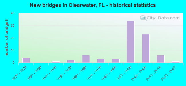
- New bridges - historical statistics
- 41920-1929
- 11940-1949
- 21950-1959
- 61960-1969
- 31970-1979
- 31980-1989
- 341990-1999
- 232000-2009
- 62010-2019
- 12020-2022
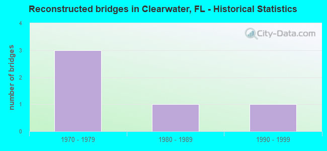
- Reconstructed bridges - Historical Statistics
- 31970-1979
- 11980-1989
- 11990-1999
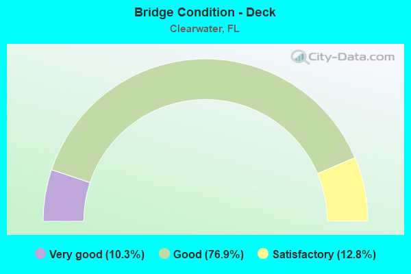
- Bridge Condition - Deck
- 10.3%Very good
- 76.9%Good
- 12.8%Satisfactory
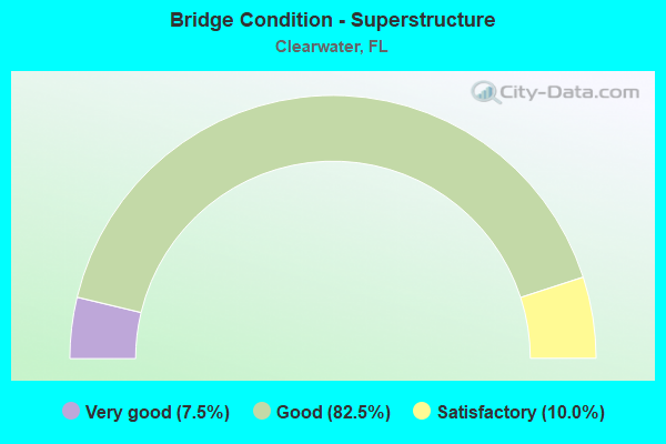
- Bridge Condition - Superstructure
- 7.5%Very good
- 82.5%Good
- 10.0%Satisfactory
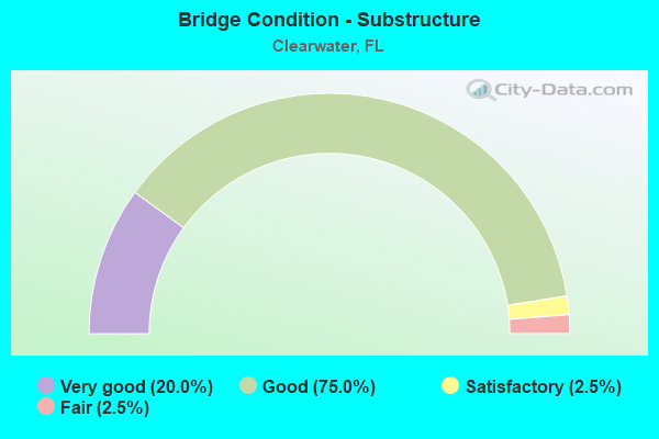
- Bridge Condition - Substructure
- 20.0%Very good
- 75.0%Good
- 2.5%Satisfactory
- 2.5%Fair
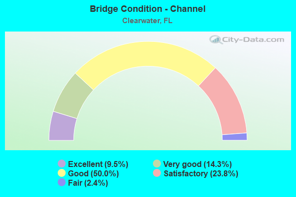
- Bridge Condition - Channel
- 9.5%Excellent
- 14.3%Very good
- 50.0%Good
- 23.8%Satisfactory
- 2.4%Fair
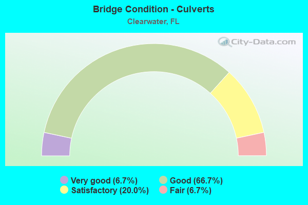
- Bridge Condition - Culverts
- 6.7%Very good
- 66.7%Good
- 20.0%Satisfactory
- 6.7%Fair
Find on map >> Show street view
Structure Number: 150007, Location: 0.9 MILE EAST OF US-19A (Lat: 27.968122, Lng: -82.781619), Route carried "on" structure: State highway 590, Year Built: 1927, Year Reconstructed: 1970, Status: Open, Structure Length: 0.92m (3.02ft), Average Daily Traffic: 18,800 (year 2020), Truck Traffic: 4%, Average Future Daily Traffic: 32,618 (year 2042), Design Load: H 15, Features Intersected: STEVENSONS CREEK
Minimum Vertical Clearance: 30+ m (98+ ft), Kilometerpoint: 1.806, Lanes on structure: 4, Owner: State Highway Agency, Approaching Roadway Width: 13.0m (42.7ft), Material/Design: Concrete, Design/Construction: Arch - Deck, Number Of Spans In Main Unit: 1, Length of Maximum Span: 9.2m (30.2ft), Curb or Sidewalk Widths: Left: 1.3m (4.3ft), Right: 1.5m (4.9ft), Curb-To-Curb Width: 13.0m (42.7ft), Out-to-Out Width: 16.7m (54.8ft)
Condition: Deck: Good, Superstructure: Good, Substructure: Good, Channel: Excellent, Operating Rating: 54.4 metric tons, Method Used To Determine Operating Rating: Load Testing, Inventory Rating: 32.7 metric tons, Method Used To Determine Inventory Rating: Load Testing, Structural Evaluation: Better than present minimum criteria, Deck Geometry: High priority of replacement, Waterway Adequacy: Equal to present desirable criteria, Approach Roadway Alignment: Equal to present desirable criteria, Designated Inspection Frequency: Every 24 months, Inspection Date: March 2020, Deck Structure Type: Concrete Cast-file-Place, Wearing Surface/Protective System: Wearing Surface: Bituminous
Find on map >> Show street view
Structure Number: 150033, Location: 0.9 MILE NORTH OF SR-60 (Lat: 27.973147, Lng: -82.729769), Route carried "on" structure: US 19, Year Built: 1948, Year Reconstructed: 1982, Status: Open, Structure Length: 1.28m (4.20ft), Average Daily Traffic: 111,000 (year 2020), Truck Traffic: 4%, Average Future Daily Traffic: 192,585 (year 2042), Design Load: H 15, Features Intersected: ALLIGATOR CREEK
Minimum Vertical Clearance: 30+ m (98+ ft), Kilometerpoint: 30.940, Lanes on structure: 8, Base Highway Network: Yes, Owner: State Highway Agency, Approaching Roadway Width: 46.0m (150.9ft), Skew: 30 degrees, Material/Design: Concrete, Design/Construction: Culvert, Number Of Spans In Main Unit: 4, Length of Maximum Span: 3.1m (10.2ft)
Condition: Channel: Satisfactory, Culverts: Good, Operating Rating: 74.8 metric tons, Method Used To Determine Operating Rating: Load Factor (LF), Inventory Rating: 44.8 metric tons, Method Used To Determine Inventory Rating: Load Factor (LF), Structural Evaluation: Better than present minimum criteria, Waterway Adequacy: Equal to present desirable criteria, Approach Roadway Alignment: Equal to present desirable criteria, Designated Inspection Frequency: Every 24 months, Inspection Date: March 2020
Find on map >> Show street view
Structure Number: 150043, Location: 0.1 MI. E OF GULF BLVD. (Lat: 27.977583, Lng: -82.823861), Route carried "on" structure: State highway 60, Year Built: 1960, Status: Open, Structure Length: 9.85m (32.32ft), Average Daily Traffic: 34,000 (year 2020), Truck Traffic: 4%, Average Future Daily Traffic: 58,990 (year 2042), Design Load: H 20, Features Intersected: CLEARWATER HARBOR
Minimum Vertical Clearance: 30+ m (98+ ft), Kilometerpoint: 0.317, Lanes on structure: 4, Base Highway Network: Yes, Owner: State Highway Agency, Approaching Roadway Width: 18.3m (60.0ft), Skew: 20 degrees, Material/Design: Prestressed concrete, Design/Construction: Slab, Number Of Spans In Main Unit: 5, Length of Maximum Span: 21.0m (68.9ft), Curb or Sidewalk Widths: Left: 1.5m (4.9ft), Right: 1.5m (4.9ft), Curb-To-Curb Width: 17.1m (56.1ft), Out-to-Out Width: 22.6m (74.1ft)
Condition: Deck: Satisfactory, Superstructure: Satisfactory, Substructure: Good, Channel: Good, Operating Rating: 39.9 metric tons, Method Used To Determine Operating Rating: Allowable Stress (AS), Inventory Rating: 29.9 metric tons, Method Used To Determine Inventory Rating: Allowable Stress (AS), Structural Evaluation: Equal to present minimum criteria, Deck Geometry: Somewhat better than minimum adequacy, Waterway Adequacy: Equal to present desirable criteria, Approach Roadway Alignment: Equal to present desirable criteria, Designated Inspection Frequency: Every 24 months, Underwater Inspection Frequency: Every 24 months, Inspection Date: March 2020, Underwater Inspection Date: Febuary 2020, Deck Structure Type: Concrete Precast Panels, Wearing Surface/Protective System: Wearing Surface: Integral Concrete
Find on map >> Show street view
Structure Number: 150082, Location: 1MI NORTH OF SR-60 (Lat: 27.976319, Lng: -82.729789), Route carried "on" structure: US 19, Year Built: 1959, Year Reconstructed: 1981, Status: Open, Structure Length: 5.93m (19.46ft), Average Daily Traffic: 111,000 (year 2020), Truck Traffic: 4%, Average Future Daily Traffic: 192,585 (year 2042), Design Load: HS 20, Features Intersected: CSX RR/EAST WEST TRAIL
Minimum Vertical Clearance: 30+ m (98+ ft), Kilometerpoint: 31.266, Lanes on structure: 8, Base Highway Network: Yes, Owner: State Highway Agency, Approaching Roadway Width: 43.0m (141.1ft), Skew: 39 degrees, Material/Design: Prestressed concrete, Design/Construction: Stringer/Multi-beam, Number Of Spans In Main Unit: 5, Length of Maximum Span: 14.7m (48.2ft), Curb-To-Curb Width: 42.2m (138.5ft), Out-to-Out Width: 45.1m (148.0ft)
Condition: Deck: Good, Superstructure: Good, Substructure: Good, Operating Rating: 70.9 metric tons, Method Used To Determine Operating Rating: Load Factor (LF), Inventory Rating: 42.5 metric tons, Method Used To Determine Inventory Rating: Load Factor (LF), Structural Evaluation: Better than present minimum criteria, Deck Geometry: Superior to present desirable criteria, Underclear: Somewhat better than minimum adequacy, Approach Roadway Alignment: Equal to present desirable criteria, Designated Inspection Frequency: Every 24 months, Inspection Date: March 2020, Deck Structure Type: Concrete Cast-file-Place
Find on map >> Show street view
Structure Number: 150111, Location: 0.25 MI. E OF US-19A (Lat: 27.960789, Lng: -82.783428), Route carried "on" structure: State highway 651, Year Built: 1952, Status: Open, Structure Length: 1.41m (4.63ft), Average Daily Traffic: 36,500 (year 2020), Truck Traffic: 5%, Average Future Daily Traffic: 63,328 (year 2042), Design Load: H 15, Features Intersected: STEVENSONS CREEK
Minimum Vertical Clearance: 30+ m (98+ ft), Kilometerpoint: 5.295, Lanes on structure: 4, Base Highway Network: Yes, Owner: State Highway Agency, Approaching Roadway Width: 21.4m (70.2ft), Skew: 20 degrees, Material/Design: Concrete, Design/Construction: Culvert, Number Of Spans In Main Unit: 4, Length of Maximum Span: 3.0m (9.8ft)
Condition: Channel: Very good, Culverts: Satisfactory, Operating Rating: 56.2 metric tons, Method Used To Determine Operating Rating: Load Factor (LF), Inventory Rating: 33.6 metric tons, Method Used To Determine Inventory Rating: Load Factor (LF), Structural Evaluation: Equal to present minimum criteria, Waterway Adequacy: Equal to present desirable criteria, Approach Roadway Alignment: Equal to present desirable criteria, Designated Inspection Frequency: Every 24 months, Underwater Inspection Frequency: Every 24 months, Inspection Date: March 2020, Underwater Inspection Date: Febuary 2020
Find on map >> Show street view
Structure Number: 150113, Location: 0.7MI WEST OF US-19 (Lat: 27.976400, Lng: -82.739736), Route carried "on" structure: State highway 590, Year Built: 1927, Status: Open, Structure Length: 1.13m (3.71ft), Average Daily Traffic: 10,900 (year 2020), Truck Traffic: 4%, Average Future Daily Traffic: 18,912 (year 2042), Design Load: HL 93, Features Intersected: ALLIGATOR CREEK
Minimum Vertical Clearance: 30+ m (98+ ft), Kilometerpoint: 6.236, Lanes on structure: 2, Owner: State Highway Agency, Approaching Roadway Width: 8.6m (28.2ft), Material/Design: Concrete, Design/Construction: Arch - Thru, Number Of Spans In Main Unit: 1, Length of Maximum Span: 11.3m (37.1ft), Curb-To-Curb Width: 8.6m (28.2ft), Out-to-Out Width: 10.6m (34.8ft)
Condition: Deck: Good, Superstructure: Good, Substructure: Good, Channel: Good, Operating Rating: 41.5 metric tons, Method Used To Determine Operating Rating: Load and Resistance Factor (LRFR), Inventory Rating: 32.7 metric tons, Method Used To Determine Inventory Rating: Load and Resistance Factor (LRFR), Structural Evaluation: Better than present minimum criteria, Deck Geometry: High priority of replacement, Waterway Adequacy: Equal to present desirable criteria, Approach Roadway Alignment: Equal to present desirable criteria, Designated Inspection Frequency: Every 24 months, Inspection Date: March 2020, Deck Structure Type: Concrete Cast-file-Place, Wearing Surface/Protective System: Wearing Surface: Bituminous
Find on map >> Show street view
Structure Number: 150138, Location: 3.0 MI EAST OF US-19 (Lat: 27.963422, Lng: -82.678478), Route carried "on" structure: State highway 60, Year Built: 1974, Year Reconstructed: 1993, Status: Open, Structure Length: 14.54m (47.70ft), Average Daily Traffic: 52,000 (year 2020), Truck Traffic: 6%, Average Future Daily Traffic: 90,220 (year 2042), Design Load: HS 20, Features Intersected: OLD TAMPA BAY
Minimum Vertical Clearance: 30.45m (99.90ft), Kilometerpoint: 12.152, Lanes on structure: 4, Base Highway Network: Yes, Owner: State Highway Agency, Approaching Roadway Width: 26.0m (85.3ft), Skew: 30 degrees, Material/Design: Prestressed concrete, Design/Construction: Stringer/Multi-beam, Number Of Spans In Main Unit: 11, Length of Maximum Span: 13.5m (44.3ft), Curb-To-Curb Width: 25.5m (83.7ft), Out-to-Out Width: 27.7m (90.9ft)
Condition: Deck: Good, Superstructure: Good, Substructure: Good, Channel: Very good, Operating Rating: 75.3 metric tons, Method Used To Determine Operating Rating: Allowable Stress (AS), Inventory Rating: 48.1 metric tons, Method Used To Determine Inventory Rating: Allowable Stress (AS), Structural Evaluation: Better than present minimum criteria, Deck Geometry: Superior to present desirable criteria, Waterway Adequacy: Equal to present desirable criteria, Approach Roadway Alignment: Equal to present desirable criteria, Designated Inspection Frequency: Every 24 months, Underwater Inspection Frequency: Every 24 months, Inspection Date: March 2020, Underwater Inspection Date: Febuary 2020, Deck Structure Type: Concrete Cast-file-Place
Find on map >> Show street view
Structure Number: 150173, Location: 1.6 MILE N OF SR-590 (Lat: 27.989722, Lng: -82.795667), Route carried "on" structure: Alternate US 19, Year Built: 1983, Status: Open, Structure Length: 3.56m (11.68ft), Average Daily Traffic: 15,700 (year 2020), Truck Traffic: 3%, Average Future Daily Traffic: 27,240 (year 2042), Design Load: HS 20+Mod, Features Intersected: STEVENSON'S CREEK
Minimum Vertical Clearance: 30+ m (98+ ft), Kilometerpoint: 2.430, Lanes on structure: 3, Owner: State Highway Agency, Approaching Roadway Width: 16.7m (54.8ft), Material/Design: Prestressed concrete, Design/Construction: Slab, Number Of Spans In Main Unit: 3, Length of Maximum Span: 11.8m (38.7ft), Curb or Sidewalk Widths: Left: 4.7m (15.4ft), Right: 0.0m, Curb-To-Curb Width: 16.4m (53.8ft), Out-to-Out Width: 22.4m (73.5ft)
Condition: Deck: Good, Superstructure: Good, Substructure: Good, Channel: Very good, Operating Rating: 60.8 metric tons, Method Used To Determine Operating Rating: Allowable Stress (AS), Inventory Rating: 45.4 metric tons, Method Used To Determine Inventory Rating: Allowable Stress (AS), Structural Evaluation: Better than present minimum criteria, Deck Geometry: Better than present minimum criteria, Waterway Adequacy: Equal to present desirable criteria, Approach Roadway Alignment: Equal to present desirable criteria, Designated Inspection Frequency: Every 24 months, Underwater Inspection Frequency: Every 24 months, Inspection Date: March 2020, Underwater Inspection Date: Febuary 2020, Deck Structure Type: Concrete Precast Panels, Wearing Surface/Protective System: Wearing Surface: Bituminous
Find on map >> Show street view
Structure Number: 150205, Location: 1.1 MI. EAST OF US-19A (Lat: 27.965642, Lng: -82.781531), Route carried "on" structure: Business State highway 60, Year Built: 1992, Status: Open, Structure Length: 1.12m (3.67ft), Average Daily Traffic: 4,600 (year 2020), Truck Traffic: 4%, Average Future Daily Traffic: 7,981 (year 2042), Design Load: HS 20+Mod, Features Intersected: STEVENSONS CREEK
Minimum Vertical Clearance: 30+ m (98+ ft), Kilometerpoint: 1.809, Lanes on structure: 5, Owner: State Highway Agency, Approaching Roadway Width: 17.4m (57.1ft), Material/Design: Concrete, Design/Construction: Culvert, Number Of Spans In Main Unit: 3, Length of Maximum Span: 4.0m (13.1ft)
Condition: Channel: Good, Culverts: Good, Operating Rating: 82.6 metric tons, Method Used To Determine Operating Rating: Load Factor (LF), Inventory Rating: 49.5 metric tons, Method Used To Determine Inventory Rating: Load Factor (LF), Structural Evaluation: Better than present minimum criteria, Waterway Adequacy: Superior to present desirable criteria, Approach Roadway Alignment: Equal to present desirable criteria, Designated Inspection Frequency: Every 24 months, Inspection Date: March 2020
Find on map >> Show street view
Structure Number: 150209, Location: INTERSECT US-19 & SR-580 (Lat: 28.019306, Lng: -82.738083), Route carried "on" structure: US 19, Year Built: 1994, Status: Open, Structure Length: 12.95m (42.49ft), Average Daily Traffic: 106,000 (year 2020), Truck Traffic: 4%, Average Future Daily Traffic: 183,910 (year 2042), Design Load: HL 93, Features Intersected: SR-580
Minimum Vertical Clearance: 30+ m (98+ ft), Kilometerpoint: 36.278, Lanes on structure: 6, Lanes under structure: 10, Base Highway Network: Yes, Owner: State Highway Agency, Approaching Roadway Width: 34.0m (111.5ft), Skew: 30 degrees, Material/Design: Prestressed concrete continuous, Design/Construction: Box Beam or Girders - Multiple, Number Of Spans In Main Unit: 3, Length of Maximum Span: 56.4m (185.0ft), Curb-To-Curb Width: 34.0m (111.5ft), Out-to-Out Width: 35.6m (116.8ft)
Condition: Deck: Good, Superstructure: Good, Substructure: Very good, Operating Rating: 66.0 metric tons, Method Used To Determine Operating Rating: Load and Resistance Factor (LRFR), Inventory Rating: 34.3 metric tons, Method Used To Determine Inventory Rating: Load and Resistance Factor (LRFR), Structural Evaluation: Better than present minimum criteria, Deck Geometry: Superior to present desirable criteria, Underclear: Equal to present minimum criteria, Approach Roadway Alignment: Equal to present desirable criteria, Designated Inspection Frequency: Every 24 months, Inspection Date: March 2020, Deck Structure Type: Concrete Cast-file-Place
Find on map >> Show street view
Structure Number: 150216, Location: 2000FT. SOUTH OF SR-580 (Lat: 28.014306, Lng: -82.736306), Route carried "on" structure: US 19, Year Built: 1994, Status: Open, Structure Length: 21.90m (71.85ft), Average Daily Traffic: 80,000 (year 2015), Truck Traffic: 3%, Average Future Daily Traffic: 138,800 (year 2037), Design Load: HS 20+Mod, Features Intersected: COUNTRYSIDE BLVD
Minimum Vertical Clearance: 6.28m (20.60ft), Kilometerpoint: 35.612, Lanes on structure: 8, Lanes under structure: 10, Base Highway Network: Yes, Owner: State Highway Agency, Approaching Roadway Width: 39.0m (128.0ft), Skew: 31 degrees, Material/Design: Prestressed concrete continuous, Design/Construction: Box Beam or Girders - Multiple, Number Of Spans In Main Unit: 5, Length of Maximum Span: 52.1m (170.9ft), Curb-To-Curb Width: 39.0m (128.0ft), Out-to-Out Width: 40.5m (132.9ft)
Condition: Deck: Good, Superstructure: Good, Substructure: Good, Operating Rating: 47.2 metric tons, Method Used To Determine Operating Rating: Load Factor (LF), Inventory Rating: 41.7 metric tons, Method Used To Determine Inventory Rating: Load Factor (LF), Structural Evaluation: Better than present minimum criteria, Deck Geometry: Superior to present desirable criteria, Underclear: Better than present minimum criteria, Approach Roadway Alignment: Equal to present desirable criteria, Designated Inspection Frequency: Every 24 months, Inspection Date: March 2020, Deck Structure Type: Concrete Cast-file-Place
Find on map >> Show street view
Structure Number: 150226, Location: 0.5MI N OF SR-60 (Lat: 27.967861, Lng: -82.729889), Route carried "on" structure: US 19, Year Built: 2005, Status: Open, Structure Length: 26.63m (87.37ft), Average Daily Traffic: 111,000 (year 2020), Truck Traffic: 4%, Average Future Daily Traffic: 192,585 (year 2042), Design Load: HS 20, Features Intersected: CR-528 (DREW ST.)
Minimum Vertical Clearance: 30+ m (98+ ft), Kilometerpoint: 30.298, Lanes on structure: 6, Lanes under structure: 10, Base Highway Network: Yes, Owner: State Highway Agency, Approaching Roadway Width: 35.0m (114.8ft), Skew: 32 degrees, Material/Design: Steel continuous, Design/Construction: Box Beam or Girders - Single/Spread, Number Of Spans In Main Unit: 5, Length of Maximum Span: 62.2m (204.1ft), Curb-To-Curb Width: 34.2m (112.2ft), Out-to-Out Width: 35.8m (117.5ft)
Condition: Deck: Very good, Superstructure: Good, Substructure: Very good, Operating Rating: 68.9 metric tons, Method Used To Determine Operating Rating: Load Factor (LF), Inventory Rating: 41.2 metric tons, Method Used To Determine Inventory Rating: Load Factor (LF), Structural Evaluation: Better than present minimum criteria, Deck Geometry: Superior to present desirable criteria, Underclear: Better than present minimum criteria, Approach Roadway Alignment: Equal to present desirable criteria, Designated Inspection Frequency: Every 24 months, Inspection Date: March 2020, Deck Structure Type: Concrete Cast-file-Place
Find on map >> Show street view
Structure Number: 150231, Location: 0.2MI N OF DREW ST. (Lat: 27.971344, Lng: -82.728094), Route carried "on" structure: State highway , Year Built: 2005, Status: Open, Structure Length: 4.48m (14.70ft), Average Daily Traffic: 300 (year 2018), Truck Traffic: 1%, Average Future Daily Traffic: 521 (year 2040), Design Load: HS 25 or greater, Features Intersected: POND 4D, Facility Carried by Structure: ACCESS ROAD A
Minimum Vertical Clearance: 30+ m (98+ ft), Kilometerpoint: 0.369, Lanes on structure: 2, Owner: State Highway Agency, Approaching Roadway Width: 9.4m (30.8ft), Skew: 9 degrees, Material/Design: Concrete continuous, Design/Construction: Slab, Number Of Spans In Main Unit: 5, Length of Maximum Span: 8.8m (28.9ft), Curb-To-Curb Width: 10.3m (33.8ft), Out-to-Out Width: 11.2m (36.7ft)
Condition: Deck: Good, Superstructure: Very good, Substructure: Very good, Channel: Excellent, Operating Rating: 60.4 metric tons, Method Used To Determine Operating Rating: Load Factor (LF), Inventory Rating: 36.3 metric tons, Method Used To Determine Inventory Rating: Load Factor (LF), Structural Evaluation: Equal to present desirable criteria, Deck Geometry: Better than present minimum criteria, Waterway Adequacy: Equal to present desirable criteria, Approach Roadway Alignment: Equal to present minimum criteria, Designated Inspection Frequency: Every 24 months, Inspection Date: March 2020, Deck Structure Type: Concrete Cast-file-Place
Find on map >> Show street view
Structure Number: 150244, Location: 0.3MI W OF US-19A/SR-595 (Lat: 27.966292, Lng: -82.806094), Route carried "on" structure: State highway 60, Year Built: 2005, Status: Open, Structure Length: 71.32m (233.99ft), Average Daily Traffic: 34,000 (year 2020), Truck Traffic: 4%, Average Future Daily Traffic: 58,990 (year 2042), Design Load: HS 20+Mod, Features Intersected: CLEARWATER HARBOR
Minimum Vertical Clearance: 30+ m (98+ ft), Kilometerpoint: 0.269, Lanes on structure: 4, Lanes under structure: 2, Base Highway Network: Yes, Owner: State Highway Agency, Approaching Roadway Width: 22.0m (72.2ft), Skew: 29 degrees, Navigation Control: Yes ( Vertical Clearance: 22.6m (74.1ft), Horizontal Clearance: 45.7m (149.9ft)), Material/Design: Prestressed concrete continuous, Design/Construction: Segmental Box Girder, Number Of Spans In Main Unit: 9, Length of Maximum Span: 109.7m (359.9ft), Curb or Sidewalk Widths: Left: 2.1m (6.9ft), Right: 3.7m (12.1ft), Curb-To-Curb Width: 22.0m (72.2ft), Out-to-Out Width: 34.3m (112.5ft)
Condition: Deck: Satisfactory, Superstructure: Good, Substructure: Good, Channel: Good, Operating Rating: 39.6 metric tons, Method Used To Determine Operating Rating: Load Factor (LF), Inventory Rating: 33.3 metric tons, Method Used To Determine Inventory Rating: Load Factor (LF), Structural Evaluation: Better than present minimum criteria, Deck Geometry: Superior to present desirable criteria, Waterway Adequacy: Equal to present desirable criteria, Approach Roadway Alignment: Equal to present desirable criteria, Designated Inspection Frequency: Every 24 months, Underwater Inspection Frequency: Every 24 months, Inspection Date: January 2022, Underwater Inspection Date: December 2021, Deck Structure Type: Other
Find on map >> Show street view
Structure Number: 150245, Location: 2.1MI NORTH OF SR-60 (Lat: 27.990806, Lng: -82.729500), Route carried "on" structure: US 19, Year Built: 2007, Status: Open, Structure Length: 15.20m (49.87ft), Average Daily Traffic: 49,500 (year 2020), Truck Traffic: 4%, Average Future Daily Traffic: 85,882 (year 2042), Design Load: HS 20+Mod, Features Intersected: SUNSET POINT RD.
Minimum Vertical Clearance: 30+ m (98+ ft), Kilometerpoint: 32.718, Lanes on structure: 3, Lanes under structure: 10, Base Highway Network: Yes, Owner: State Highway Agency, Approaching Roadway Width: 15.9m (52.2ft), Material/Design: Steel continuous, Design/Construction: Box Beam or Girders - Single/Spread, Number Of Spans In Main Unit: 3, Length of Maximum Span: 67.5m (221.5ft), Curb-To-Curb Width: 15.9m (52.2ft), Out-to-Out Width: 16.9m (55.4ft)
Condition: Deck: Satisfactory, Superstructure: Good, Substructure: Good, Operating Rating: 44.8 metric tons, Method Used To Determine Operating Rating: Load Factor (LF), Inventory Rating: 34.5 metric tons, Method Used To Determine Inventory Rating: Load Factor (LF), Structural Evaluation: Better than present minimum criteria, Deck Geometry: Better than present minimum criteria, Underclear: Equal to present minimum criteria, Approach Roadway Alignment: Equal to present desirable criteria, Designated Inspection Frequency: Every 24 months, Critical Feature Inspection Frequency: Every 12 months, Inspection Date: August 2020, Critical Feature Inspection Date: August 2021, Deck Structure Type: Concrete Cast-file-Place
Find on map >> Show street view
Structure Number: 150246, Location: 2.1MI NORTH OF SR-60 (Lat: 27.990806, Lng: -82.729667), Route carried "on" structure: US 19, Year Built: 2006, Status: Open, Structure Length: 15.20m (49.87ft), Average Daily Traffic: 49,500 (year 2020), Truck Traffic: 4%, Average Future Daily Traffic: 85,882 (year 2042), Design Load: HS 20+Mod, Features Intersected: SUNSET POINT RD.
Minimum Vertical Clearance: 30+ m (98+ ft), Kilometerpoint: 32.831, Lanes on structure: 3, Lanes under structure: 10, Base Highway Network: Yes, Owner: State Highway Agency, Approaching Roadway Width: 15.9m (52.2ft), Material/Design: Steel continuous, Design/Construction: Box Beam or Girders - Single/Spread, Number Of Spans In Main Unit: 3, Length of Maximum Span: 67.5m (221.5ft), Curb-To-Curb Width: 15.9m (52.2ft), Out-to-Out Width: 16.9m (55.4ft)
Condition: Deck: Good, Superstructure: Good, Substructure: Very good, Operating Rating: 44.8 metric tons, Method Used To Determine Operating Rating: Load Factor (LF), Inventory Rating: 34.5 metric tons, Method Used To Determine Inventory Rating: Load Factor (LF), Structural Evaluation: Better than present minimum criteria, Deck Geometry: Better than present minimum criteria, Underclear: Equal to present minimum criteria, Approach Roadway Alignment: Equal to present desirable criteria, Designated Inspection Frequency: Every 24 months, Critical Feature Inspection Frequency: Every 12 months, Inspection Date: August 2020, Critical Feature Inspection Date: August 2021, Deck Structure Type: Concrete Cast-file-Place
Find on map >> Show street view
Structure Number: 150247, Location: 1.5MI NORTH OF SR-60 (Lat: 27.982556, Lng: -82.729611), Route carried "on" structure: US 19, Year Built: 2007, Status: Open, Structure Length: 13.80m (45.28ft), Average Daily Traffic: 55,500 (year 2020), Truck Traffic: 4%, Average Future Daily Traffic: 96,292 (year 2042), Design Load: HS 20+Mod, Features Intersected: NE COACHMAN RD.
Minimum Vertical Clearance: 30+ m (98+ ft), Kilometerpoint: 31.886, Lanes on structure: 3, Lanes under structure: 8, Base Highway Network: Yes, Owner: State Highway Agency, Approaching Roadway Width: 15.9m (52.2ft), Material/Design: Steel continuous, Design/Construction: Box Beam or Girders - Single/Spread, Number Of Spans In Main Unit: 3, Length of Maximum Span: 65.0m (213.3ft), Curb-To-Curb Width: 15.9m (52.2ft), Out-to-Out Width: 16.9m (55.4ft)
Condition: Deck: Good, Superstructure: Good, Substructure: Very good, Operating Rating: 44.8 metric tons, Method Used To Determine Operating Rating: Load Factor (LF), Inventory Rating: 34.5 metric tons, Method Used To Determine Inventory Rating: Load Factor (LF), Structural Evaluation: Better than present minimum criteria, Deck Geometry: Better than present minimum criteria, Underclear: Equal to present minimum criteria, Approach Roadway Alignment: Equal to present desirable criteria, Designated Inspection Frequency: Every 24 months, Critical Feature Inspection Frequency: Every 12 months, Inspection Date: August 2020, Critical Feature Inspection Date: August 2021, Deck Structure Type: Concrete Cast-file-Place
Find on map >> Show street view
Structure Number: 150248, Location: 1.5MI NORTH OF SR-60 (Lat: 27.982556, Lng: -82.729778), Route carried "on" structure: US 19, Year Built: 2006, Status: Open, Structure Length: 13.80m (45.28ft), Average Daily Traffic: 55,500 (year 2020), Truck Traffic: 4%, Average Future Daily Traffic: 96,292 (year 2042), Design Load: HS 20+Mod, Features Intersected: NE COACHMAN RD.
Minimum Vertical Clearance: 30+ m (98+ ft), Kilometerpoint: 31.918, Lanes on structure: 3, Lanes under structure: 8, Base Highway Network: Yes, Owner: State Highway Agency, Approaching Roadway Width: 15.9m (52.2ft), Material/Design: Steel continuous, Design/Construction: Box Beam or Girders - Single/Spread, Number Of Spans In Main Unit: 3, Length of Maximum Span: 65.0m (213.3ft), Curb-To-Curb Width: 15.9m (52.2ft), Out-to-Out Width: 16.9m (55.4ft)
Condition: Deck: Very good, Superstructure: Good, Substructure: Very good, Operating Rating: 44.8 metric tons, Method Used To Determine Operating Rating: Load Factor (LF), Inventory Rating: 34.5 metric tons, Method Used To Determine Inventory Rating: Load Factor (LF), Structural Evaluation: Better than present minimum criteria, Deck Geometry: Better than present minimum criteria, Underclear: Equal to present minimum criteria, Approach Roadway Alignment: Equal to present desirable criteria, Designated Inspection Frequency: Every 24 months, Critical Feature Inspection Frequency: Every 12 months, Inspection Date: August 2020, Critical Feature Inspection Date: August 2021, Deck Structure Type: Concrete Cast-file-Place
Find on map >> Show street view
Structure Number: 15026, Location: US-19 & SR-60 INTERSECT (Lat: 27.960517, Lng: -82.730128), Route carried "on" structure: US 19, Year Built: 2014, Status: Open, Structure Length: 17.98m (58.99ft), Average Daily Traffic: 111,000 (year 2020), Truck Traffic: 4%, Average Future Daily Traffic: 192,585 (year 2042), Design Load: HL 93, Features Intersected: SR-60 (GULF TO BAY BLVD)
Minimum Vertical Clearance: 6.00m (19.69ft), Kilometerpoint: 29.454, Lanes on structure: 7, Lanes under structure: 7, Base Highway Network: Yes, Owner: State Highway Agency, Approaching Roadway Width: 35.2m (115.5ft), Skew: 30 degrees, Material/Design: Steel continuous, Design/Construction: Box Beam or Girders - Single/Spread, Number Of Spans In Main Unit: 3, Length of Maximum Span: 73.2m (240.2ft), Curb-To-Curb Width: 35.2m (115.5ft), Out-to-Out Width: 36.0m (118.1ft)
Condition: Deck: Very good, Superstructure: Very good, Substructure: Very good, Operating Rating: 45.1 metric tons, Method Used To Determine Operating Rating: Load and Resistance Factor (LRFR), Inventory Rating: 34.9 metric tons, Method Used To Determine Inventory Rating: Load and Resistance Factor (LRFR), Structural Evaluation: Equal to present desirable criteria, Deck Geometry: Superior to present desirable criteria, Underclear: Somewhat better than minimum adequacy, Approach Roadway Alignment: Equal to present desirable criteria, Designated Inspection Frequency: Every 24 months, Inspection Date: March 2020, Deck Structure Type: Concrete Cast-file-Place
Find on map >> Show street view
Structure Number: 150262, Location: 0.3 MI S OF SR-60 (Lat: 27.955225, Lng: -82.730178), Route carried "on" structure: US 19, Year Built: 2014, Status: Open, Structure Length: 6.71m (22.01ft), Average Daily Traffic: 111,000 (year 2020), Truck Traffic: 4%, Average Future Daily Traffic: 192,585 (year 2042), Design Load: HL 93, Features Intersected: SEVILLE BLVD.
Minimum Vertical Clearance: 30+ m (98+ ft), Kilometerpoint: 28.926, Lanes on structure: 6, Lanes under structure: 3, Base Highway Network: Yes, Owner: State Highway Agency, Approaching Roadway Width: 31.2m (102.4ft), Skew: 30 degrees, Material/Design: Steel, Design/Construction: Box Beam or Girders - Single/Spread, Number Of Spans In Main Unit: 1, Length of Maximum Span: 67.1m (220.1ft), Curb-To-Curb Width: 31.2m (102.4ft), Out-to-Out Width: 32.6m (107.0ft)
Condition: Deck: Very good, Superstructure: Very good, Substructure: Very good, Operating Rating: 44.1 metric tons, Method Used To Determine Operating Rating: Load and Resistance Factor (LRFR), Inventory Rating: 33.9 metric tons, Method Used To Determine Inventory Rating: Load and Resistance Factor (LRFR), Structural Evaluation: Equal to present desirable criteria, Deck Geometry: Superior to present desirable criteria, Underclear: Superior to present desirable criteria, Approach Roadway Alignment: Equal to present desirable criteria, Designated Inspection Frequency: Every 24 months, Inspection Date: March 2020, Deck Structure Type: Concrete Cast-file-Place
Find on map >> Show street view
Structure Number: 150275, Location: 1.4 MI N OF SR-686 (Lat: 27.936678, Lng: -82.730094), Route carried "on" structure: ServiceUS 19, Year Built: 2012, Status: Open, Structure Length: 5.49m (18.01ft), Average Daily Traffic: 10,800 (year 2013), Truck Traffic: 8%, Average Future Daily Traffic: 25,600 (year 2033), Design Load: HL 93, Features Intersected: ALLEN CREEK
Minimum Vertical Clearance: 30+ m (98+ ft), Kilometerpoint: 8.196, Lanes on structure: 2, Base Highway Network: Yes, Owner: State Highway Agency, Approaching Roadway Width: 8.9m (29.2ft), Material/Design: Prestressed concrete, Design/Construction: Slab, Number Of Spans In Main Unit: 5, Length of Maximum Span: 11.0m (36.1ft), Curb or Sidewalk Widths: Left: 0.0m, Right: 3.2m (10.5ft), Curb-To-Curb Width: 8.9m (29.2ft), Out-to-Out Width: 13.3m (43.6ft)
Condition: Deck: Good, Superstructure: Good, Substructure: Good, Channel: Satisfactory, Operating Rating: 45.7 metric tons, Method Used To Determine Operating Rating: Load and Resistance Factor (LRFR), Inventory Rating: 32.7 metric tons, Method Used To Determine Inventory Rating: Load and Resistance Factor (LRFR), Structural Evaluation: Better than present minimum criteria, Deck Geometry: High priority of corrective action, Waterway Adequacy: Equal to present desirable criteria, Approach Roadway Alignment: Equal to present desirable criteria, Designated Inspection Frequency: Every 24 months, Underwater Inspection Frequency: Every 24 months, Inspection Date: Febuary 2021, Underwater Inspection Date: January 2021, Deck Structure Type: Concrete Precast Panels
Find on map >> Show street view
Structure Number: 154138, Location: 1.3 MI NORTH OF SR-60 (Lat: 27.978972, Lng: -82.708833), Route carried "on" structure: County highway 611, Year Built: 1990, Status: Open, Structure Length: 4.11m (13.48ft), Average Daily Traffic: 20,750 (year 2020), Truck Traffic: 4%, Average Future Daily Traffic: 36,002 (year 2042), Design Load: HS 20, Features Intersected: ALLIGATOR CREEK
Minimum Vertical Clearance: 30+ m (98+ ft), Kilometerpoint: 2.021, Lanes on structure: 3, Base Highway Network: Yes, Owner: County Highway Agency, Approaching Roadway Width: 12.5m (41.0ft), Skew: 2 degrees, Material/Design: Prestressed concrete, Design/Construction: Stringer/Multi-beam, Number Of Spans In Main Unit: 3, Length of Maximum Span: 13.7m (44.9ft), Curb or Sidewalk Widths: Left: 0.0m, Right: 2.5m (8.2ft), Curb-To-Curb Width: 17.0m (55.8ft), Out-to-Out Width: 20.7m (67.9ft)
Condition: Deck: Good, Superstructure: Good, Substructure: Good, Channel: Good, Operating Rating: 49.9 metric tons, Method Used To Determine Operating Rating: Load Factor (LF), Inventory Rating: 44.5 metric tons, Method Used To Determine Inventory Rating: Load Factor (LF), Structural Evaluation: Better than present minimum criteria, Deck Geometry: Superior to present desirable criteria, Waterway Adequacy: Superior to present desirable criteria, Approach Roadway Alignment: Equal to present desirable criteria, Designated Inspection Frequency: Every 24 months, Inspection Date: September 2021, Deck Structure Type: Concrete Cast-file-Place
Find on map >> Show street view
Structure Number: 154139, Location: 1.3 MI NORTH OF SR-60 (Lat: 27.978889, Lng: -82.709056), Route carried "on" structure: County highway 611, Year Built: 1989, Status: Open, Structure Length: 4.11m (13.48ft), Average Daily Traffic: 20,750 (year 2020), Truck Traffic: 4%, Average Future Daily Traffic: 36,002 (year 2042), Design Load: HS 20, Features Intersected: ALLIGATOR CREEK
Minimum Vertical Clearance: 30+ m (98+ ft), Kilometerpoint: 2.021, Lanes on structure: 3, Base Highway Network: Yes, Owner: County Highway Agency, Approaching Roadway Width: 13.0m (42.7ft), Skew: 2 degrees, Material/Design: Prestressed concrete, Design/Construction: Stringer/Multi-beam, Number Of Spans In Main Unit: 3, Length of Maximum Span: 13.7m (44.9ft), Curb or Sidewalk Widths: Left: 2.5m (8.2ft), Right: 0.0m, Curb-To-Curb Width: 17.1m (56.1ft), Out-to-Out Width: 20.7m (67.9ft)
Condition: Deck: Good, Superstructure: Good, Substructure: Good, Channel: Good, Operating Rating: 49.9 metric tons, Method Used To Determine Operating Rating: Load Factor (LF), Inventory Rating: 44.5 metric tons, Method Used To Determine Inventory Rating: Load Factor (LF), Structural Evaluation: Better than present minimum criteria, Deck Geometry: Superior to present desirable criteria, Waterway Adequacy: Superior to present desirable criteria, Approach Roadway Alignment: Equal to present desirable criteria, Designated Inspection Frequency: Every 24 months, Inspection Date: September 2021, Deck Structure Type: Concrete Cast-file-Place
Find on map >> Show street view
Structure Number: 154199, Location: 0.7 MI S OF CR-576 (Lat: 27.978917, Lng: -82.783639), Route carried "on" structure: County highway 365, Year Built: 1995, Status: Open, Structure Length: 3.19m (10.47ft), Average Daily Traffic: 6,700 (year 2020), Truck Traffic: 4%, Average Future Daily Traffic: 11,625 (year 2042), Design Load: HS 20, Features Intersected: STEVENSON CREEK
Minimum Vertical Clearance: 30+ m (98+ ft), Kilometerpoint: 1.183, Lanes on structure: 2, Owner: County Highway Agency, Approaching Roadway Width: 12.2m (40.0ft), Skew: 3 degrees, Material/Design: Prestressed concrete, Design/Construction: Slab, Number Of Spans In Main Unit: 3, Length of Maximum Span: 10.6m (34.8ft), Curb or Sidewalk Widths: Left: 1.6m (5.2ft), Right: 1.6m (5.2ft), Curb-To-Curb Width: 15.5m (50.9ft), Out-to-Out Width: 20.2m (66.3ft)
Condition: Deck: Good, Superstructure: Good, Substructure: Good, Channel: Good, Structural Evaluation: Better than present minimum criteria, Deck Geometry: Superior to present desirable criteria, Waterway Adequacy: Superior to present desirable criteria, Approach Roadway Alignment: Equal to present desirable criteria, Designated Inspection Frequency: Every 24 months, Underwater Inspection Frequency: Every 24 months, Inspection Date: September 2021, Underwater Inspection Date: August 2021, Deck Structure Type: Concrete Precast Panels
Find on map >> Show street view
Structure Number: 154201, Location: 0.2 MI W OF HIGHLAND AVE (Lat: 27.949783, Lng: -82.779639), Route carried "on" structure: County highway , Year Built: 1985, Status: Open, Structure Length: 2.57m (8.43ft), Average Daily Traffic: 5,200 (year 2020), Truck Traffic: 4%, Average Future Daily Traffic: 9,022 (year 2042), Design Load: HS 20, Features Intersected: STEVENSON CREEK, Facility Carried by Structure: LAKEVIEW RD.
Minimum Vertical Clearance: 30+ m (98+ ft), Kilometerpoint: 1.603, Lanes on structure: 2, Owner: County Highway Agency, Approaching Roadway Width: 6.9m (22.6ft), Skew: 1 degrees, Material/Design: Prestressed concrete, Design/Construction: Slab, Number Of Spans In Main Unit: 2, Length of Maximum Span: 12.8m (42.0ft), Curb or Sidewalk Widths: Left: 1.5m (4.9ft), Right: 1.5m (4.9ft), Curb-To-Curb Width: 9.7m (31.8ft), Out-to-Out Width: 13.7m (44.9ft)
Condition: Deck: Good, Superstructure: Good, Substructure: Good, Channel: Satisfactory, Operating Rating: 43.3 metric tons, Method Used To Determine Operating Rating: Load Factor (LF), Inventory Rating: 27.2 metric tons, Method Used To Determine Inventory Rating: Load Factor (LF), Structural Evaluation: Equal to present minimum criteria, Deck Geometry: High priority of corrective action, Waterway Adequacy: Equal to present minimum criteria, Approach Roadway Alignment: Equal to present desirable criteria, Designated Inspection Frequency: Every 24 months, Inspection Date: September 2021, Deck Structure Type: Concrete Precast Panels, Wearing Surface/Protective System: Wearing Surface: Bituminous
Find on map >> Show street view
Structure Number: 154205, Location: 0.2 MI WEST OF BELCHER RD (Lat: 27.942222, Lng: -82.749750), Route carried "on" structure: County highway , Year Built: 1966, Status: Open, Structure Length: 0.81m (2.66ft), Average Daily Traffic: 3,900 (year 2020), Truck Traffic: 4%, Average Future Daily Traffic: 6,767 (year 2042), Design Load: HS 20, Features Intersected: ALLENS CREEK, Facility Carried by Structure: NURSERY ROAD
Minimum Vertical Clearance: 30+ m (98+ ft), Kilometerpoint: 3.534, Lanes on structure: 2, Owner: County Highway Agency, Approaching Roadway Width: 6.4m (21.0ft), Skew: 2 degrees, Material/Design: Concrete, Design/Construction: Culvert, Number Of Spans In Main Unit: 2, Length of Maximum Span: 3.9m (12.8ft), Curb or Sidewalk Widths: Left: 1.2m (3.9ft), Right: 1.8m (5.9ft)
Condition: Channel: Satisfactory, Culverts: Good, Operating Rating: 65.2 metric tons, Method Used To Determine Operating Rating: Load Factor (LF), Inventory Rating: 39.5 metric tons, Method Used To Determine Inventory Rating: Load Factor (LF), Structural Evaluation: Better than present minimum criteria, Waterway Adequacy: Equal to present desirable criteria, Approach Roadway Alignment: Equal to present desirable criteria, Designated Inspection Frequency: Every 24 months, Inspection Date: September 2021
Find on map >> Show street view
Structure Number: 154252, Location: 0.5 MI N OF DREW STREET (Lat: 27.975472, Lng: -82.734278), Route carried "on" structure: County highway , Year Built: 1925, Status: Open, Structure Length: 0.73m (2.40ft), Average Daily Traffic: 8,900 (year 2020), Truck Traffic: 4%, Average Future Daily Traffic: 5,442 (year 2042), Features Intersected: ALLIGATOR CREEK, Facility Carried by Structure: OLD COACHMAN ROAD
Minimum Vertical Clearance: 30+ m (98+ ft), Kilometerpoint: 1.670, Lanes on structure: 2, Owner: County Highway Agency, Approaching Roadway Width: 5.9m (19.4ft), Material/Design: Concrete, Design/Construction: Arch - Deck, Number Of Spans In Main Unit: 1, Length of Maximum Span: 7.3m (24.0ft), Curb-To-Curb Width: 5.9m (19.4ft), Out-to-Out Width: 7.0m (23.0ft)
Condition: Superstructure: Satisfactory, Substructure: Good, Channel: Satisfactory, Structural Evaluation: Equal to present minimum criteria, Deck Geometry: High priority of replacement, Waterway Adequacy: Better than present minimum criteria, Approach Roadway Alignment: Somewhat better than minimum adequacy, Designated Inspection Frequency: Every 24 months, Inspection Date: September 2021
Find on map >> Show street view
Structure Number: 154254, Location: 0.7 MILE EAST OF US-19 (Lat: 27.923597, Lng: -82.717625), Route carried "on" structure: County highway 438, Year Built: 1971, Status: Open, Structure Length: 0.96m (3.15ft), Average Daily Traffic: 9,300 (year 2020), Truck Traffic: 4%, Average Future Daily Traffic: 16,136 (year 2042), Features Intersected: LONG BRANCH CREEK, Facility Carried by Structure: WHITNEY RD
Minimum Vertical Clearance: 30+ m (98+ ft), Kilometerpoint: 1.276, Lanes on structure: 2, Owner: County Highway Agency, Approaching Roadway Width: 7.9m (25.9ft), Material/Design: Concrete, Design/Construction: Culvert, Number Of Spans In Main Unit: 3, Length of Maximum Span: 3.1m (10.2ft)
Condition: Channel: Satisfactory, Culverts: Satisfactory, Operating Rating: 52.7 metric tons, Method Used To Determine Operating Rating: Load Factor (LF), Inventory Rating: 31.7 metric tons, Method Used To Determine Inventory Rating: Load Factor (LF), Structural Evaluation: Equal to present minimum criteria, Waterway Adequacy: Better than present minimum criteria, Approach Roadway Alignment: Equal to present minimum criteria, Designated Inspection Frequency: Every 24 months, Inspection Date: September 2021
Find on map >> Show street view
Structure Number: 154255, Location: 1.1 MI N OF ULMERTON RD (Lat: 27.910306, Lng: -82.700803), Route carried "on" structure: County highway 611, Year Built: 1993, Status: Open, Structure Length: 6.37m (20.90ft), Average Daily Traffic: 36,500 (year 2020), Truck Traffic: 6%, Average Future Daily Traffic: 63,328 (year 2042), Design Load: HS 20, Features Intersected: SR-686/ROOSEVELT BLVD
Minimum Vertical Clearance: 11.86m (38.91ft), Kilometerpoint: 4.208, Lanes on structure: 2, Lanes under structure: 9, Base Highway Network: Yes, Owner: County Highway Agency, Approaching Roadway Width: 12.1m (39.7ft), Skew: 9 degrees, Material/Design: Prestressed concrete, Design/Construction: Stringer/Multi-beam, Number Of Spans In Main Unit: 2, Length of Maximum Span: 33.2m (108.9ft), Curb-To-Curb Width: 12.1m (39.7ft), Out-to-Out Width: 13.1m (43.0ft)
Condition: Deck: Good, Superstructure: Good, Substructure: Good, Operating Rating: 88.6 metric tons, Method Used To Determine Operating Rating: Load Factor (LF), Inventory Rating: 53.8 metric tons, Method Used To Determine Inventory Rating: Load Factor (LF), Structural Evaluation: Better than present minimum criteria, Deck Geometry: Better than present minimum criteria, Underclear: High priority of corrective action, Approach Roadway Alignment: Equal to present desirable criteria, Designated Inspection Frequency: Every 24 months, Inspection Date: September 2021, Deck Structure Type: Concrete Cast-file-Place
Find on map >> Show street view
Structure Number: 154256, Location: 0.1 MI N OF ROOSEVELT BVD (Lat: 27.911797, Lng: -82.700611), Route carried "on" structure: County highway 611, Year Built: 1993, Status: Open, Structure Length: 9.14m (29.99ft), Average Daily Traffic: 18,250 (year 2020), Truck Traffic: 6%, Average Future Daily Traffic: 31,664 (year 2042), Design Load: HS 20, Features Intersected: CROSS BAYOU CANAL
Minimum Vertical Clearance: 11.86m (38.91ft), Kilometerpoint: 4.374, Lanes on structure: 2, Base Highway Network: Yes, Owner: County Highway Agency, Approaching Roadway Width: 12.1m (39.7ft), Skew: 2 degrees, Material/Design: Concrete continuous, Design/Construction: Slab, Number Of Spans In Main Unit: 10, Length of Maximum Span: 9.4m (30.8ft), Curb-To-Curb Width: 12.1m (39.7ft), Out-to-Out Width: 12.8m (42.0ft)
Condition: Deck: Good, Superstructure: Good, Substructure: Good, Channel: Good, Operating Rating: 78.8 metric tons, Method Used To Determine Operating Rating: Load Factor (LF), Inventory Rating: 47.3 metric tons, Method Used To Determine Inventory Rating: Load Factor (LF), Structural Evaluation: Better than present minimum criteria, Deck Geometry: Better than present minimum criteria, Waterway Adequacy: Equal to present desirable criteria, Approach Roadway Alignment: Better than present minimum criteria, Designated Inspection Frequency: Every 24 months, Underwater Inspection Frequency: Every 24 months, Inspection Date: September 2021, Underwater Inspection Date: August 2021, Deck Structure Type: Concrete Cast-file-Place
Find on map >> Show street view
Structure Number: 154257, Location: 0.2MI N OF ROOSEVELT BLVD (Lat: 27.911306, Lng: -82.701233), Route carried "on" structure: Ramp Other road 611, Year Built: 1993, Status: Open, Structure Length: 12.83m (42.09ft), Average Daily Traffic: 5,300 (year 2021), Truck Traffic: 4%, Average Future Daily Traffic: 9,196 (year 2042), Design Load: HS 20, Features Intersected: CROSS BAYOU CANAL
Minimum Vertical Clearance: 5.46m (17.91ft), Kilometerpoint: 0.000, Lanes on structure: 2, Owner: County Highway Agency, Approaching Roadway Width: 7.2m (23.6ft), Material/Design: Concrete continuous, Design/Construction: Slab, Number Of Spans In Main Unit: 14, Length of Maximum Span: 9.2m (30.2ft), Curb-To-Curb Width: 16.5m (54.1ft), Out-to-Out Width: 16.7m (54.8ft)
Condition: Deck: Good, Superstructure: Good, Substructure: Good, Channel: Good, Operating Rating: 80.5 metric tons, Method Used To Determine Operating Rating: Load Factor (LF), Inventory Rating: 48.3 metric tons, Method Used To Determine Inventory Rating: Load Factor (LF), Structural Evaluation: Better than present minimum criteria, Deck Geometry: Superior to present desirable criteria, Waterway Adequacy: Equal to present desirable criteria, Approach Roadway Alignment: Better than present minimum criteria, Designated Inspection Frequency: Every 24 months, Underwater Inspection Frequency: Every 24 months, Inspection Date: September 2021, Underwater Inspection Date: August 2021, Deck Structure Type: Concrete Cast-file-Place
Find on map >> Show street view
Structure Number: 154258, Location: 0.1MI N OF ROOSEVELT BLVD (Lat: 27.912267, Lng: -82.700097), Route carried "on" structure: ServiceOther road , Year Built: 1993, Status: Open, Structure Length: 10.97m (35.99ft), Average Daily Traffic: 1,250 (year 2021), Truck Traffic: 5%, Average Future Daily Traffic: 2,169 (year 2042), Design Load: HS 20, Features Intersected: CROSS BAYOU CANAL, Facility Carried by Structure: SERVICE ROAD
Minimum Vertical Clearance: 11.86m (38.91ft), Kilometerpoint: 0.000, Lanes on structure: 2, Owner: County Highway Agency, Approaching Roadway Width: 8.5m (27.9ft), Skew: 2 degrees, Material/Design: Concrete continuous, Design/Construction: Slab, Number Of Spans In Main Unit: 12, Length of Maximum Span: 9.4m (30.8ft), Curb or Sidewalk Widths: Left: 0.0m, Right: 1.8m (5.9ft), Curb-To-Curb Width: 12.1m (39.7ft), Out-to-Out Width: 13.0m (42.7ft)
Condition: Deck: Good, Superstructure: Good, Substructure: Good, Channel: Good, Operating Rating: 75.7 metric tons, Method Used To Determine Operating Rating: Load Factor (LF), Inventory Rating: 45.4 metric tons, Method Used To Determine Inventory Rating: Load Factor (LF), Structural Evaluation: Better than present minimum criteria, Deck Geometry: Equal to present minimum criteria, Waterway Adequacy: Better than present minimum criteria, Approach Roadway Alignment: Better than present minimum criteria, Designated Inspection Frequency: Every 24 months, Underwater Inspection Frequency: Every 24 months, Inspection Date: September 2021, Underwater Inspection Date: August 2021, Deck Structure Type: Concrete Cast-file-Place
Find on map >> Show street view
Structure Number: 154259, Location: BETWEEN SR-686 & SR-60 (Lat: 27.944969, Lng: -82.704822), Route carried "on" structure: County highway 611, Year Built: 1993, Status: Open, Structure Length: 427.04m (1401.05ft), Average Daily Traffic: 32,000 (year 2019), Truck Traffic: 6%, Average Future Daily Traffic: 55,520 (year 2041), Design Load: HS 20, Features Intersected: TAMPA BAY, Facility Carried by Structure: 49TH ST. NB
Minimum Vertical Clearance: 5.63m (18.47ft), Kilometerpoint: 5.639, Lanes on structure: 2, Base Highway Network: Yes, Owner: County Highway Agency, Approaching Roadway Width: 12.1m (39.7ft), Navigation Control: Yes ( Vertical Clearance: 14.0m (45.9ft), Horizontal Clearance: 19.0m (62.3ft)), Material/Design: Prestressed concrete, Design/Construction: Stringer/Multi-beam, Number Of Spans In Main Unit: 95, Number Of Approach Spans: 115, Length of Maximum Span: 30.5m (100.1ft), Curb-To-Curb Width: 12.1m (39.7ft), Out-to-Out Width: 13.0m (42.7ft)
Condition: Deck: Satisfactory, Superstructure: Good, Substructure: Good, Channel: Good, Operating Rating: 50.6 metric tons, Method Used To Determine Operating Rating: Load Factor (LF), Inventory Rating: 28.8 metric tons, Method Used To Determine Inventory Rating: Load Factor (LF), Structural Evaluation: Better than present minimum criteria, Deck Geometry: Better than present minimum criteria, Waterway Adequacy: Better than present minimum criteria, Approach Roadway Alignment: Equal to present desirable criteria, Designated Inspection Frequency: Every 24 months, Underwater Inspection Frequency: Every 24 months, Inspection Date: Febuary 2021, Underwater Inspection Date: January 2021, Deck Structure Type: Concrete Cast-file-Place, Wearing Surface/Protective System: Deck Protection: Epoxy Coated Reinforcing
Find on map >> Show street view
Structure Number: 15426, Location: BETWEEN SR-686 AND SR-60 (Lat: 27.944922, Lng: -82.705094), Route carried "on" structure: County highway 611, Year Built: 1993, Status: Open, Structure Length: 427.04m (1401.05ft), Average Daily Traffic: 32,000 (year 2019), Truck Traffic: 6%, Average Future Daily Traffic: 55,520 (year 2041), Design Load: HS 20, Features Intersected: TAMPA BAY, Facility Carried by Structure: 49TH ST. SB
Minimum Vertical Clearance: 6.07m (19.91ft), Kilometerpoint: 5.639, Lanes on structure: 2, Base Highway Network: Yes, Owner: County Highway Agency, Approaching Roadway Width: 12.1m (39.7ft), Navigation Control: Yes ( Vertical Clearance: 14.0m (45.9ft), Horizontal Clearance: 19.0m (62.3ft)), Material/Design: Prestressed concrete, Design/Construction: Stringer/Multi-beam, Number Of Spans In Main Unit: 95, Number Of Approach Spans: 115, Length of Maximum Span: 30.5m (100.1ft), Curb-To-Curb Width: 12.1m (39.7ft), Out-to-Out Width: 13.0m (42.7ft)
Condition: Deck: Satisfactory, Superstructure: Good, Substructure: Good, Channel: Good, Operating Rating: 49.1 metric tons, Method Used To Determine Operating Rating: Load Factor (LF), Inventory Rating: 27.3 metric tons, Method Used To Determine Inventory Rating: Load Factor (LF), Structural Evaluation: Equal to present minimum criteria, Deck Geometry: Better than present minimum criteria, Waterway Adequacy: Better than present minimum criteria, Approach Roadway Alignment: Equal to present desirable criteria, Designated Inspection Frequency: Every 24 months, Underwater Inspection Frequency: Every 24 months, Inspection Date: Febuary 2021, Underwater Inspection Date: January 2021, Deck Structure Type: Concrete Cast-file-Place, Wearing Surface/Protective System: Deck Protection: Epoxy Coated Reinforcing
Find on map >> Show street view
Structure Number: 154261, Location: 1.1MI N OF ULMERTON RD (Lat: 27.910392, Lng: -82.700944), Route carried "on" structure: County highway 611, Year Built: 1993, Status: Open, Structure Length: 5.99m (19.65ft), Average Daily Traffic: 36,500 (year 2020), Truck Traffic: 6%, Average Future Daily Traffic: 63,328 (year 2042), Design Load: HS 20, Features Intersected: SR-686/ROOSEVELT BLVD
Minimum Vertical Clearance: 11.86m (38.91ft), Kilometerpoint: 4.225, Lanes on structure: 2, Lanes under structure: 9, Base Highway Network: Yes, Owner: County Highway Agency, Approaching Roadway Width: 12.1m (39.7ft), Skew: 9 degrees, Material/Design: Prestressed concrete, Design/Construction: Stringer/Multi-beam, Number Of Spans In Main Unit: 2, Length of Maximum Span: 30.9m (101.4ft), Curb-To-Curb Width: 12.1m (39.7ft), Out-to-Out Width: 13.1m (43.0ft)
Condition: Deck: Good, Superstructure: Good, Substructure: Good, Operating Rating: 85.8 metric tons, Method Used To Determine Operating Rating: Load Factor (LF), Inventory Rating: 52.3 metric tons, Method Used To Determine Inventory Rating: Load Factor (LF), Structural Evaluation: Better than present minimum criteria, Deck Geometry: Better than present minimum criteria, Underclear: High priority of corrective action, Approach Roadway Alignment: Equal to present desirable criteria, Designated Inspection Frequency: Every 24 months, Inspection Date: September 2021, Deck Structure Type: Concrete Cast-file-Place
Find on map >> Show street view
Structure Number: 154262, Location: 0.1MI N OF ROOSEVELT BLVD (Lat: 27.911661, Lng: -82.700814), Route carried "on" structure: County highway 611, Year Built: 1993, Status: Open, Structure Length: 9.14m (29.99ft), Average Daily Traffic: 18,250 (year 2020), Truck Traffic: 6%, Average Future Daily Traffic: 31,664 (year 2042), Design Load: HS 20, Features Intersected: CROSS BAYOU CANAL
Minimum Vertical Clearance: 30.45m (99.90ft), Kilometerpoint: 4.374, Lanes on structure: 2, Base Highway Network: Yes, Owner: County Highway Agency, Approaching Roadway Width: 12.3m (40.4ft), Skew: 2 degrees, Material/Design: Concrete continuous, Design/Construction: Slab, Number Of Spans In Main Unit: 10, Length of Maximum Span: 9.3m (30.5ft), Curb-To-Curb Width: 12.3m (40.4ft), Out-to-Out Width: 13.5m (44.3ft)
Condition: Deck: Good, Superstructure: Good, Substructure: Good, Channel: Good, Operating Rating: 80.5 metric tons, Method Used To Determine Operating Rating: Load Factor (LF), Inventory Rating: 48.3 metric tons, Method Used To Determine Inventory Rating: Load Factor (LF), Structural Evaluation: Better than present minimum criteria, Deck Geometry: Better than present minimum criteria, Waterway Adequacy: Equal to present desirable criteria, Approach Roadway Alignment: Better than present minimum criteria, Designated Inspection Frequency: Every 24 months, Underwater Inspection Frequency: Every 24 months, Inspection Date: September 2021, Underwater Inspection Date: August 2021, Deck Structure Type: Concrete Cast-file-Place
Find on map >> Show street view
Structure Number: 154263, Location: 0.2MI N OF ROOSEVELT BLVD (Lat: 27.911975, Lng: -82.700408), Route carried "on" structure: Ramp County highway 611, Year Built: 1993, Year Reconstructed: 2004, Status: Open, Structure Length: 5.10m (16.73ft), Average Daily Traffic: 2,400 (year 2020), Truck Traffic: 4%, Average Future Daily Traffic: 4,164 (year 2042), Design Load: HS 20, Features Intersected: CROSS BAYOU CANAL
Minimum Vertical Clearance: 30+ m (98+ ft), Kilometerpoint: 0.192, Lanes on structure: 2, Owner: County Highway Agency, Approaching Roadway Width: 12.2m (40.0ft), Skew: 1 degrees, Material/Design: Concrete continuous, Design/Construction: Slab, Number Of Spans In Main Unit: 6, Length of Maximum Span: 8.7m (28.5ft), Curb-To-Curb Width: 12.2m (40.0ft), Out-to-Out Width: 13.1m (43.0ft)
Condition: Deck: Good, Superstructure: Good, Substructure: Good, Channel: Good, Operating Rating: 39.8 metric tons, Method Used To Determine Operating Rating: Load and Resistance Factor (LRFR), Inventory Rating: 30.7 metric tons, Method Used To Determine Inventory Rating: Load and Resistance Factor (LRFR), Structural Evaluation: Better than present minimum criteria, Deck Geometry: Superior to present desirable criteria, Waterway Adequacy: Equal to present desirable criteria, Approach Roadway Alignment: Better than present minimum criteria, Designated Inspection Frequency: Every 24 months, Underwater Inspection Frequency: Every 24 months, Inspection Date: September 2021, Underwater Inspection Date: August 2021, Deck Structure Type: Concrete Cast-file-Place, Wearing Surface/Protective System: Deck Protection: Epoxy Coated Reinforcing
Find on map >> Show street view
Structure Number: 154265, Location: AT SR-60 (Lat: 27.958439, Lng: -82.709086), Route carried "on" structure: Ramp County highway 611, Year Built: 1993, Status: Open, Structure Length: 16.62m (54.53ft), Average Daily Traffic: 5,200 (year 2018), Truck Traffic: 5%, Average Future Daily Traffic: 7,150 (year 2040), Design Load: HS 20, Features Intersected: TAMPA BAY
Minimum Vertical Clearance: 30+ m (98+ ft), Kilometerpoint: 0.148, Lanes on structure: 2, Owner: County Highway Agency, Approaching Roadway Width: 12.1m (39.7ft), Material/Design: Prestressed concrete, Design/Construction: Stringer/Multi-beam, Number Of Spans In Main Unit: 11, Length of Maximum Span: 16.9m (55.4ft), Curb-To-Curb Width: 12.1m (39.7ft), Out-to-Out Width: 13.0m (42.7ft)
Condition: Deck: Good, Superstructure: Good, Substructure: Good, Channel: Excellent, Operating Rating: 72.2 metric tons, Method Used To Determine Operating Rating: Load Factor (LF), Inventory Rating: 38.0 metric tons, Method Used To Determine Inventory Rating: Load Factor (LF), Structural Evaluation: Better than present minimum criteria, Deck Geometry: Superior to present desirable criteria, Waterway Adequacy: Equal to present minimum criteria, Approach Roadway Alignment: Better than present minimum criteria, Designated Inspection Frequency: Every 24 months, Inspection Date: Febuary 2021, Deck Structure Type: Concrete Cast-file-Place, Wearing Surface/Protective System: Deck Protection: Epoxy Coated Reinforcing
Find on map >> Show street view
Structure Number: 154266, Location: MC MULLEN BOOTH @ SR-60 (Lat: 27.960703, Lng: -82.708972), Route carried "on" structure: County highway 611, Year Built: 1993, Status: Open, Structure Length: 14.44m (47.38ft), Average Daily Traffic: 64,000 (year 2019), Truck Traffic: 6%, Average Future Daily Traffic: 111,040 (year 2042), Design Load: HS 20, Features Intersected: SR-60
Minimum Vertical Clearance: 30+ m (98+ ft), Kilometerpoint: 9.672, Lanes on structure: 4, Lanes under structure: 9, Base Highway Network: Yes, Owner: County Highway Agency, Approaching Roadway Width: 24.7m (81.0ft), Skew: 30 degrees, Material/Design: Steel, Design/Construction: Stringer/Multi-beam, Number Of Spans In Main Unit: 1, Number Of Approach Spans: 3, Length of Maximum Span: 52.6m (172.6ft), Curb-To-Curb Width: 24.7m (81.0ft), Out-to-Out Width: 26.1m (85.6ft)
Condition: Deck: Good, Superstructure: Good, Substructure: Good, Operating Rating: 60.6 metric tons, Method Used To Determine Operating Rating: Load Factor (LF), Inventory Rating: 36.4 metric tons, Method Used To Determine Inventory Rating: Load Factor (LF), Structural Evaluation: Better than present minimum criteria, Deck Geometry: Superior to present desirable criteria, Underclear: Equal to present minimum criteria, Approach Roadway Alignment: Equal to present desirable criteria, Designated Inspection Frequency: Every 24 months, Inspection Date: Febuary 2021, Deck Structure Type: Concrete Cast-file-Place, Wearing Surface/Protective System: Deck Protection: Epoxy Coated Reinforcing
Find on map >> Show street view
Structure Number: 154267, Location: AT SR-60 (Lat: 27.958522, Lng: -82.708542), Route carried "on" structure: Ramp County highway 611, Year Built: 1993, Status: Open, Structure Length: 15.96m (52.36ft), Average Daily Traffic: 5,200 (year 2018), Truck Traffic: 5%, Average Future Daily Traffic: 9,022 (year 2040), Design Load: HS 20, Features Intersected: TAMPA BAY
Minimum Vertical Clearance: 30+ m (98+ ft), Kilometerpoint: 0.013, Lanes on structure: 2, Owner: County Highway Agency, Approaching Roadway Width: 12.0m (39.4ft), Material/Design: Prestressed concrete, Design/Construction: Stringer/Multi-beam, Number Of Spans In Main Unit: 11, Length of Maximum Span: 14.6m (47.9ft), Curb-To-Curb Width: 12.0m (39.4ft), Out-to-Out Width: 13.4m (44.0ft)
Condition: Deck: Good, Superstructure: Good, Substructure: Good, Channel: Good, Operating Rating: 61.3 metric tons, Method Used To Determine Operating Rating: Load Factor (LF), Inventory Rating: 33.7 metric tons, Method Used To Determine Inventory Rating: Load Factor (LF), Structural Evaluation: Better than present minimum criteria, Deck Geometry: Superior to present desirable criteria, Waterway Adequacy: Equal to present minimum criteria, Approach Roadway Alignment: Better than present minimum criteria, Designated Inspection Frequency: Every 24 months, Inspection Date: Febuary 2021, Deck Structure Type: Concrete Cast-file-Place, Wearing Surface/Protective System: Deck Protection: Epoxy Coated Reinforcing
Find on map >> Show street view
Structure Number: 154269, Location: 500 FT S OF NURSERY RD (Lat: 27.940664, Lng: -82.750633), Route carried "on" structure: ServiceOther road , Year Built: 2003, Status: Open, Structure Length: 0.72m (2.36ft), Average Daily Traffic: 6 (year 2021), Average Future Daily Traffic: 11 (year 2042), Features Intersected: ALLENS CREEK, Facility Carried by Structure: OAKADIA DRIVE
Minimum Vertical Clearance: 30.18m (99.02ft), Kilometerpoint: 0.000, Lanes on structure: 1, Owner: County Highway Agency, Approaching Roadway Width: 3.1m (10.2ft), Material/Design: Concrete, Design/Construction: Culvert, Number Of Spans In Main Unit: 2, Length of Maximum Span: 3.4m (11.2ft)
Condition: Channel: Good, Culverts: Good, Operating Rating: 34.5 metric tons, Method Used To Determine Operating Rating: Load Factor (LF), Inventory Rating: 20.7 metric tons, Method Used To Determine Inventory Rating: Load Factor (LF), Structural Evaluation: Equal to present minimum criteria, Waterway Adequacy: Equal to present desirable criteria, Approach Roadway Alignment: High priority of replacement, Designated Inspection Frequency: Every 24 months, Inspection Date: August 2021
Find on map >> Show street view
Structure Number: 154568, Location: 0.2MI EAST OF DOUGLAS AVE (Lat: 27.990056, Lng: -82.784222), Route carried "on" structure: County highway 576, Year Built: 2020, Status: Open, Structure Length: 0.66m (2.17ft), Average Daily Traffic: 7,500 (year 2021), Truck Traffic: 4%, Average Future Daily Traffic: 9,000 (year 2041), Design Load: HL 93, Features Intersected: SPRING BRANCH CREEK
Minimum Vertical Clearance: 30.18m (99.02ft), Kilometerpoint: 0.000, Lanes on structure: 2, Owner: County Highway Agency, Approaching Roadway Width: 13.2m (43.3ft), Skew: 1 degrees, Material/Design: Concrete, Design/Construction: Culvert, Number Of Spans In Main Unit: 2, Length of Maximum Span: 3.3m (10.8ft)
Condition: Channel: Very good, Culverts: Very good, Operating Rating: 56.8 metric tons, Method Used To Determine Operating Rating: Load and Resistance Factor (LRFR), Inventory Rating: 46.7 metric tons, Method Used To Determine Inventory Rating: Load and Resistance Factor (LRFR), Structural Evaluation: Equal to present desirable criteria, Waterway Adequacy: Better than present minimum criteria, Approach Roadway Alignment: Equal to present desirable criteria, Designated Inspection Frequency: Every 24 months, Inspection Date: January 2021
Find on map >> Show street view
Structure Number: 155501, Location: 1MI NORTH OF SR-60 (Lat: 27.986017, Lng: -82.818689), Route carried "on" structure: City street , Year Built: 1965, Status: Open, Structure Length: 0.82m (2.69ft), Average Daily Traffic: 6,250 (year 2019), Truck Traffic: 4%, Average Future Daily Traffic: 10,844 (year 2041), Design Load: HS 20, Features Intersected: CLEARWATER HARBOR CANAL, Facility Carried by Structure: ISLAND WAY NB
Minimum Vertical Clearance: 30+ m (98+ ft), Kilometerpoint: 1.358, Lanes on structure: 2, Owner: City or Municipal Highway Agency, Approaching Roadway Width: 6.3m (20.7ft), Material/Design: Prestressed concrete, Design/Construction: Tee Beam, Number Of Spans In Main Unit: 1, Length of Maximum Span: 8.2m (26.9ft), Curb or Sidewalk Widths: Left: 0.3m (1.0ft), Right: 1.4m (4.6ft), Curb-To-Curb Width: 7.4m (24.3ft), Out-to-Out Width: 9.8m (32.2ft)
Condition: Deck: Good, Superstructure: Satisfactory, Substructure: Good, Channel: Very good, Operating Rating: 58.4 metric tons, Method Used To Determine Operating Rating: Load Testing, Inventory Rating: 32.7 metric tons, Method Used To Determine Inventory Rating: Load Testing, Structural Evaluation: Equal to present minimum criteria, Deck Geometry: High priority of replacement, Waterway Adequacy: Better than present minimum criteria, Approach Roadway Alignment: Equal to present desirable criteria, Designated Inspection Frequency: Every 24 months, Underwater Inspection Frequency: Every 24 months, Inspection Date: January 2021, Underwater Inspection Date: December 2020, Deck Structure Type: Concrete Cast-file-Place, Wearing Surface/Protective System: Wearing Surface: Bituminous