Bridge Statistics for Clearwater, Florida (FL)
Condition, Traffic, Stress, Structural Evaluation, Project Costs
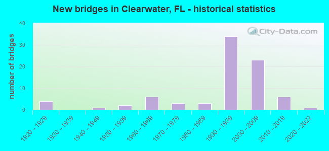
- New bridges - historical statistics
- 41920-1929
- 11940-1949
- 21950-1959
- 61960-1969
- 31970-1979
- 31980-1989
- 341990-1999
- 232000-2009
- 62010-2019
- 12020-2022
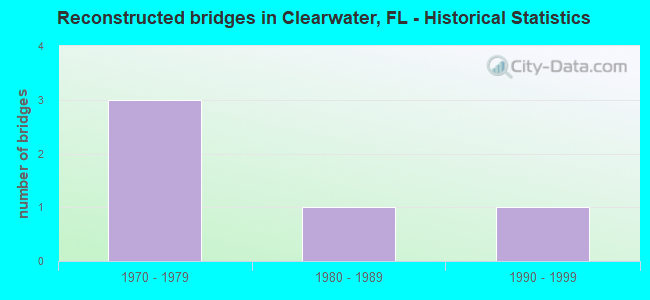
- Reconstructed bridges - Historical Statistics
- 31970-1979
- 11980-1989
- 11990-1999
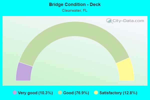
- Bridge Condition - Deck
- 10.3%Very good
- 76.9%Good
- 12.8%Satisfactory
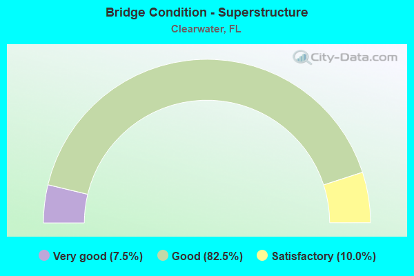
- Bridge Condition - Superstructure
- 7.5%Very good
- 82.5%Good
- 10.0%Satisfactory
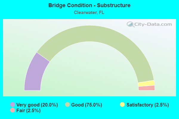
- Bridge Condition - Substructure
- 20.0%Very good
- 75.0%Good
- 2.5%Satisfactory
- 2.5%Fair
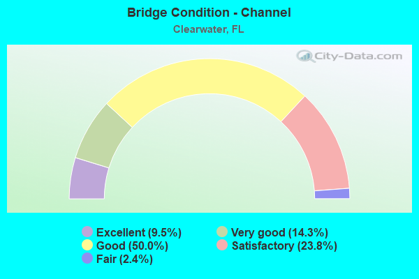
- Bridge Condition - Channel
- 9.5%Excellent
- 14.3%Very good
- 50.0%Good
- 23.8%Satisfactory
- 2.4%Fair
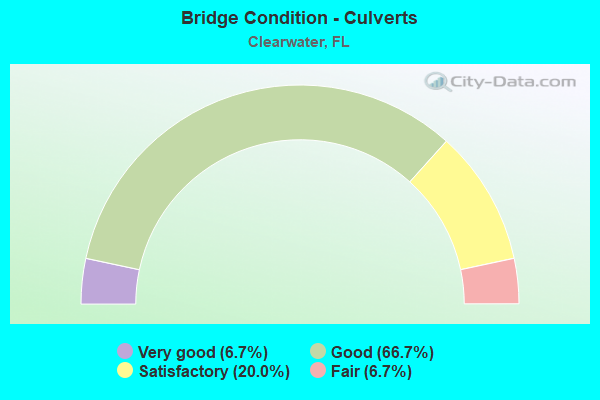
- Bridge Condition - Culverts
- 6.7%Very good
- 66.7%Good
- 20.0%Satisfactory
- 6.7%Fair
Find on map >> Show street view
Structure Number: 155502, Location: 1MI NORTH OF SR-60 (Lat: 27.985953, Lng: -82.818811), Route carried "on" structure: City street , Year Built: 1965, Status: Open, Structure Length: 0.82m (2.69ft), Average Daily Traffic: 6,250 (year 2019), Truck Traffic: 4%, Average Future Daily Traffic: 10,844 (year 2041), Design Load: HS 20, Features Intersected: CLEARWATER HARBOR CAN., Facility Carried by Structure: ISLAND WAY SB
Minimum Vertical Clearance: 30+ m (98+ ft), Kilometerpoint: 1.358, Lanes on structure: 2, Owner: City or Municipal Highway Agency, Approaching Roadway Width: 6.4m (21.0ft), Material/Design: Prestressed concrete, Design/Construction: Tee Beam, Number Of Spans In Main Unit: 1, Length of Maximum Span: 8.2m (26.9ft), Curb or Sidewalk Widths: Left: 1.4m (4.6ft), Right: 0.3m (1.0ft), Curb-To-Curb Width: 7.4m (24.3ft), Out-to-Out Width: 9.8m (32.2ft)
Condition: Deck: Good, Superstructure: Satisfactory, Substructure: Good, Channel: Very good, Operating Rating: 58.4 metric tons, Method Used To Determine Operating Rating: Load Testing, Inventory Rating: 32.7 metric tons, Method Used To Determine Inventory Rating: Load Testing, Structural Evaluation: Equal to present minimum criteria, Deck Geometry: High priority of replacement, Waterway Adequacy: Better than present minimum criteria, Approach Roadway Alignment: Better than present minimum criteria, Designated Inspection Frequency: Every 24 months, Underwater Inspection Frequency: Every 24 months, Inspection Date: January 2021, Underwater Inspection Date: December 2020, Deck Structure Type: Concrete Cast-file-Place, Wearing Surface/Protective System: Wearing Surface: Bituminous
Find on map >> Show street view
Structure Number: 155503, Location: 0.5 MILE SOUTH OF CR-576 (Lat: 27.983206, Lng: -82.788147), Route carried "on" structure: City street , Year Built: 1967, Status: Posted for load-capacity, Structure Length: 4.10m (13.45ft), Average Daily Traffic: 4,900 (year 2019), Truck Traffic: 3%, Average Future Daily Traffic: 8,502 (year 2041), Design Load: H 20, Features Intersected: STEVENSON CREEK, Facility Carried by Structure: DOUGLAS AVE.
Minimum Vertical Clearance: 30+ m (98+ ft), Kilometerpoint: 0.877, Lanes on structure: 3, Owner: City or Municipal Highway Agency, Approaching Roadway Width: 11.6m (38.1ft), Material/Design: Prestressed concrete, Design/Construction: Slab, Number Of Spans In Main Unit: 3, Length of Maximum Span: 14.0m (45.9ft), Curb or Sidewalk Widths: Left: 0.4m (1.3ft), Right: 1.4m (4.6ft), Curb-To-Curb Width: 13.6m (44.6ft), Out-to-Out Width: 16.0m (52.5ft)
Condition: Deck: Good, Superstructure: Good, Substructure: Good, Channel: Good, Operating Rating: 44.5 metric tons, Method Used To Determine Operating Rating: Load Factor (LF), Inventory Rating: 19.9 metric tons, Method Used To Determine Inventory Rating: Load Factor (LF), Structural Evaluation: Somewhat better than minimum adequacy, Deck Geometry: Somewhat better than minimum adequacy, Waterway Adequacy: Better than present minimum criteria, Approach Roadway Alignment: Equal to present minimum criteria, Designated Inspection Frequency: Every 24 months, Underwater Inspection Frequency: Every 24 months, Inspection Date: January 2021, Underwater Inspection Date: December 2020, Deck Structure Type: Concrete Precast Panels, Wearing Surface/Protective System: Wearing Surface: Bituminous
Find on map >> Show street view
Structure Number: 155504, Location: 1.0 MI SOUTH OF SR-60 (Lat: 27.950722, Lng: -82.754256), Route carried "on" structure: City street , Year Built: 1965, Status: Open, Structure Length: 0.64m (2.10ft), Average Daily Traffic: 5,600 (year 2020), Truck Traffic: 1%, Average Future Daily Traffic: 9,716 (year 2042), Features Intersected: ALLEN CREEK, Facility Carried by Structure: HERCULES AVENUE
Minimum Vertical Clearance: 30+ m (98+ ft), Kilometerpoint: 1.083, Lanes on structure: 2, Owner: City or Municipal Highway Agency, Approaching Roadway Width: 8.3m (27.2ft), Skew: 1 degrees, Material/Design: Concrete, Design/Construction: Culvert, Number Of Spans In Main Unit: 2, Length of Maximum Span: 3.2m (10.5ft)
Condition: Channel: Satisfactory, Culverts: Fair, Operating Rating: 65.7 metric tons, Method Used To Determine Operating Rating: Load Factor (LF), Inventory Rating: 39.4 metric tons, Method Used To Determine Inventory Rating: Load Factor (LF), Structural Evaluation: Somewhat better than minimum adequacy, Waterway Adequacy: Better than present minimum criteria, Approach Roadway Alignment: Equal to present minimum criteria, Designated Inspection Frequency: Every 24 months, Inspection Date: January 2021
Find on map >> Show street view
Structure Number: 155507, Location: 1.0 MILE N OF DREW ST. (Lat: 27.974139, Lng: -82.720797), Route carried "on" structure: City street , Year Built: 1975, Status: Open, Structure Length: 1.72m (5.64ft), Average Daily Traffic: 4,360 (year 2020), Truck Traffic: 1%, Average Future Daily Traffic: 7,565 (year 2042), Design Load: H 20, Features Intersected: ALLIGATOR CREEK, Facility Carried by Structure: FAIRWOOD AVE.
Minimum Vertical Clearance: 30+ m (98+ ft), Kilometerpoint: 0.000, Lanes on structure: 2, Owner: City or Municipal Highway Agency, Approaching Roadway Width: 8.2m (26.9ft), Skew: 3 degrees, Material/Design: Prestressed concrete, Design/Construction: Tee Beam, Number Of Spans In Main Unit: 1, Length of Maximum Span: 17.2m (56.4ft), Curb or Sidewalk Widths: Left: 0.0m, Right: 1.0m (3.3ft), Curb-To-Curb Width: 8.9m (29.2ft), Out-to-Out Width: 10.8m (35.4ft)
Condition: Deck: Good, Superstructure: Good, Substructure: Satisfactory, Channel: Good, Operating Rating: 43.5 metric tons, Method Used To Determine Operating Rating: Load Factor (LF), Inventory Rating: 17.9 metric tons, Method Used To Determine Inventory Rating: Load Factor (LF), Structural Evaluation: Meets minimum limits, Deck Geometry: Meets minimum limits, Waterway Adequacy: Better than present minimum criteria, Approach Roadway Alignment: Meets minimum limits, Designated Inspection Frequency: Every 24 months, Inspection Date: January 2021, Deck Structure Type: Concrete Cast-file-Place, Wearing Surface/Protective System: Wearing Surface: Bituminous
Find on map >> Show street view
Structure Number: 155509, Location: 0.2MI S OF SUNSET PT. RD (Lat: 27.987253, Lng: -82.789356), Route carried "on" structure: City street , Year Built: 1926, Status: Posted for load-capacity, Structure Length: 0.62m (2.03ft), Average Daily Traffic: 500 (year 2021), Truck Traffic: 5%, Average Future Daily Traffic: 868 (year 2042), Design Load: H 15, Features Intersected: STEVENSON CREEK, Facility Carried by Structure: OVERBROOK AVENUE
Minimum Vertical Clearance: 30+ m (98+ ft), Kilometerpoint: 0.000, Lanes on structure: 2, Owner: City or Municipal Highway Agency, Approaching Roadway Width: 7.3m (24.0ft), Skew: 4 degrees, Material/Design: Concrete, Design/Construction: Culvert, Number Of Spans In Main Unit: 1, Length of Maximum Span: 6.2m (20.3ft), Curb or Sidewalk Widths: Left: 1.7m (5.6ft), Right: 1.7m (5.6ft)
Condition: Channel: Excellent, Culverts: Satisfactory, Operating Rating: 40.9 metric tons, Method Used To Determine Operating Rating: Load Factor (LF), Inventory Rating: 24.5 metric tons, Method Used To Determine Inventory Rating: Load Factor (LF), Structural Evaluation: Equal to present minimum criteria, Waterway Adequacy: Better than present minimum criteria, Approach Roadway Alignment: Better than present minimum criteria, Designated Inspection Frequency: Every 24 months, Underwater Inspection Frequency: Every 24 months, Inspection Date: January 2021, Underwater Inspection Date: December 2020
Find on map >> Show street view
Structure Number: 15551, Location: 0.3 MI E/O SR-651 (Lat: 27.964100, Lng: -82.782006), Route carried "on" structure: City street , Year Built: 1996, Status: Open, Structure Length: 0.85m (2.79ft), Average Daily Traffic: 500 (year 2021), Average Future Daily Traffic: 903 (year 2041), Design Load: HS 20, Features Intersected: STEVENSON CREEK, Facility Carried by Structure: PIERCE STREET
Minimum Vertical Clearance: 30+ m (98+ ft), Kilometerpoint: 0.000, Lanes on structure: 2, Owner: City or Municipal Highway Agency, Approaching Roadway Width: 8.5m (27.9ft), Material/Design: Concrete, Design/Construction: Culvert, Number Of Spans In Main Unit: 1, Length of Maximum Span: 8.5m (27.9ft)
Condition: Channel: Good, Culverts: Good, Operating Rating: 47.8 metric tons, Method Used To Determine Operating Rating: Load and Resistance Factor (LRFR), Inventory Rating: 36.9 metric tons, Method Used To Determine Inventory Rating: Load and Resistance Factor (LRFR), Structural Evaluation: Better than present minimum criteria, Waterway Adequacy: Better than present minimum criteria, Approach Roadway Alignment: Equal to present desirable criteria, Designated Inspection Frequency: Every 24 months, Inspection Date: June 2021
Find on map >> Show street view
Structure Number: 155511, Location: 0.3 MI W/O SR-60 (Lat: 27.962636, Lng: -82.782536), Route carried "on" structure: City street , Year Built: 1996, Status: Open, Structure Length: 1.10m (3.61ft), Average Daily Traffic: 500 (year 2021), Truck Traffic: 1%, Average Future Daily Traffic: 903 (year 2041), Design Load: HS 20, Features Intersected: STEVENSON CREEK, Facility Carried by Structure: FRANKLIN STREET
Minimum Vertical Clearance: 30+ m (98+ ft), Kilometerpoint: 0.000, Lanes on structure: 2, Owner: City or Municipal Highway Agency, Approaching Roadway Width: 8.7m (28.5ft), Material/Design: Concrete, Design/Construction: Culvert, Number Of Spans In Main Unit: 1, Length of Maximum Span: 11.0m (36.1ft)
Condition: Channel: Satisfactory, Culverts: Good, Operating Rating: 85.5 metric tons, Method Used To Determine Operating Rating: Load and Resistance Factor (LRFR), Inventory Rating: 65.9 metric tons, Method Used To Determine Inventory Rating: Load and Resistance Factor (LRFR), Structural Evaluation: Better than present minimum criteria, Waterway Adequacy: Equal to present desirable criteria, Approach Roadway Alignment: Equal to present desirable criteria, Designated Inspection Frequency: Every 24 months, Inspection Date: June 2021
Find on map >> Show street view
Structure Number: 155522, Location: 1.0 MILE SOUTH OF SR 60 (Lat: 27.961750, Lng: -82.822833), Route carried "on" structure: County highway 699, Year Built: 1995, Status: Open, Structure Length: 76.81m (252.00ft), Average Daily Traffic: 1,000 (year 2019), Truck Traffic: 4%, Average Future Daily Traffic: 1,738 (year 2041), Design Load: HS 20+Mod, Features Intersected: CLEARWATER PASS
Minimum Vertical Clearance: 30+ m (98+ ft), Kilometerpoint: 0.000, Lanes on structure: 2, Owner: City or Municipal Highway Agency, Approaching Roadway Width: 13.4m (44.0ft), Navigation Control: Yes ( Vertical Clearance: 22.6m (74.1ft), Horizontal Clearance: 27.4m (89.9ft)), Material/Design: Prestressed concrete, Design/Construction: Stringer/Multi-beam, Number Of Spans In Main Unit: 21, Length of Maximum Span: 36.6m (120.1ft), Curb or Sidewalk Widths: Left: 1.5m (4.9ft), Right: 1.5m (4.9ft), Curb-To-Curb Width: 13.4m (44.0ft), Out-to-Out Width: 18.0m (59.1ft)
Condition: Deck: Good, Superstructure: Good, Substructure: Fair, Channel: Good, Inventory Rating: 71.5 metric tons, Method Used To Determine Inventory Rating: Load Factor (LF), Structural Evaluation: Somewhat better than minimum adequacy, Deck Geometry: Superior to present desirable criteria, Waterway Adequacy: Equal to present desirable criteria, Approach Roadway Alignment: Equal to present desirable criteria, Designated Inspection Frequency: Every 24 months, Underwater Inspection Frequency: Every 24 months, Inspection Date: January 2021, Underwater Inspection Date: December 2020, Deck Structure Type: Concrete Cast-file-Place
Find on map >> Show street view
Structure Number: 155523, Location: 0.9MI E OF FORT HARRISON (Lat: 27.975403, Lng: -82.782694), Route carried "on" structure: City street , Year Built: 1993, Status: Open, Structure Length: 1.55m (5.09ft), Average Daily Traffic: 4,300 (year 2019), Truck Traffic: 4%, Average Future Daily Traffic: 7,461 (year 2041), Features Intersected: STEVENSON CREEK, Facility Carried by Structure: PALMETTO STREET
Minimum Vertical Clearance: 30+ m (98+ ft), Kilometerpoint: 1.302, Lanes on structure: 2, Owner: City or Municipal Highway Agency, Approaching Roadway Width: 8.3m (27.2ft), Material/Design: Concrete, Design/Construction: Culvert, Number Of Spans In Main Unit: 4, Length of Maximum Span: 3.7m (12.1ft), Curb or Sidewalk Widths: Left: 1.6m (5.2ft), Right: 1.5m (4.9ft)
Condition: Channel: Good, Culverts: Good, Operating Rating: 50.4 metric tons, Method Used To Determine Operating Rating: Load Factor (LF), Inventory Rating: 30.3 metric tons, Method Used To Determine Inventory Rating: Load Factor (LF), Structural Evaluation: Better than present minimum criteria, Waterway Adequacy: Equal to present minimum criteria, Approach Roadway Alignment: Equal to present desirable criteria, Designated Inspection Frequency: Every 24 months, Underwater Inspection Frequency: Every 24 months, Inspection Date: January 2021, Underwater Inspection Date: December 2020
Find on map >> Show street view
Structure Number: 155524, Location: 0.2 MI EAST OF KEENE RD (Lat: 27.956972, Lng: -82.759250), Route carried "on" structure: City street , Year Built: 1999, Status: Open, Structure Length: 0.81m (2.66ft), Average Daily Traffic: 7,600 (year 2020), Truck Traffic: 3%, Average Future Daily Traffic: 13,186 (year 2042), Features Intersected: ALLENS CREEK, Facility Carried by Structure: DRUID RD
Minimum Vertical Clearance: 30.45m (99.90ft), Kilometerpoint: 6.003, Lanes on structure: 2, Owner: City or Municipal Highway Agency, Approaching Roadway Width: 17.7m (58.1ft), Material/Design: Concrete, Design/Construction: Culvert, Number Of Spans In Main Unit: 2, Length of Maximum Span: 4.0m (13.1ft)
Condition: Channel: Satisfactory, Culverts: Good, Operating Rating: 47.0 metric tons, Method Used To Determine Operating Rating: Load and Resistance Factor (LRFR), Inventory Rating: 36.3 metric tons, Method Used To Determine Inventory Rating: Load and Resistance Factor (LRFR), Structural Evaluation: Better than present minimum criteria, Waterway Adequacy: Better than present minimum criteria, Approach Roadway Alignment: Equal to present desirable criteria, Designated Inspection Frequency: Every 24 months, Inspection Date: June 2021
Find on map >> Show street view
Structure Number: 155525, Location: 0.2 MI W/O S HIGHLAND AVE (Lat: 27.953469, Lng: -82.779308), Route carried "on" structure: City street , Year Built: 1996, Status: Open, Structure Length: 1.10m (3.61ft), Average Daily Traffic: 240 (year 2021), Truck Traffic: 1%, Average Future Daily Traffic: 416 (year 2042), Design Load: HS 20, Features Intersected: STEVENSON CREEK, Facility Carried by Structure: JEFFORDS ST
Minimum Vertical Clearance: 30+ m (98+ ft), Kilometerpoint: 0.805, Lanes on structure: 2, Owner: City or Municipal Highway Agency, Approaching Roadway Width: 10.4m (34.1ft), Material/Design: Concrete, Design/Construction: Culvert, Number Of Spans In Main Unit: 1, Length of Maximum Span: 11.0m (36.1ft)
Condition: Channel: Fair, Culverts: Good, Operating Rating: 78.2 metric tons, Method Used To Determine Operating Rating: Load and Resistance Factor (LRFR), Inventory Rating: 60.3 metric tons, Method Used To Determine Inventory Rating: Load and Resistance Factor (LRFR), Structural Evaluation: Better than present minimum criteria, Waterway Adequacy: Better than present minimum criteria, Approach Roadway Alignment: Somewhat better than minimum adequacy, Designated Inspection Frequency: Every 24 months, Inspection Date: June 2021
Find on map >> Show street view
Structure Number: 155526, Location: 0.1 MI SOUTH OF CR-638 (Lat: 28.011306, Lng: -82.713083), Route carried "on" structure: City street , Year Built: 1996, Status: Open, Structure Length: 1.16m (3.81ft), Average Daily Traffic: 8,400 (year 2020), Truck Traffic: 3%, Average Future Daily Traffic: 14,574 (year 2042), Design Load: HS 20, Features Intersected: MULLET CREEK, Facility Carried by Structure: LANDMARK DR
Minimum Vertical Clearance: 30.45m (99.90ft), Kilometerpoint: 0.000, Lanes on structure: 2, Owner: City or Municipal Highway Agency, Approaching Roadway Width: 13.9m (45.6ft), Skew: 4 degrees, Material/Design: Concrete, Design/Construction: Culvert, Number Of Spans In Main Unit: 1, Length of Maximum Span: 11.6m (38.1ft)
Condition: Channel: Satisfactory, Culverts: Good, Operating Rating: 44.1 metric tons, Method Used To Determine Operating Rating: Load and Resistance Factor (LRFR), Inventory Rating: 34.0 metric tons, Method Used To Determine Inventory Rating: Load and Resistance Factor (LRFR), Structural Evaluation: Better than present minimum criteria, Waterway Adequacy: Equal to present minimum criteria, Approach Roadway Alignment: Equal to present desirable criteria, Designated Inspection Frequency: Every 24 months, Inspection Date: June 2021
Find on map >> Show street view
Structure Number: 150209, Location: INTERSECT US-19 & SR-580 (Lat: 28.019306, Lng: -82.738083), Route carried "under" structure: State highway 580, Year Built: 1994, Structure Length: 0. m, Average Daily Traffic: 44,000 (year 2020), Truck Traffic: 4%, Features Intersected: SR-580, Facility Carried by Structure: US-19 (SR-55)
Minimum Vertical Clearance: 4.98m (16.34ft), Kilometerpoint: 5.346, Lanes on structure: 6, Lanes under structure: 8, Material/Design: Prestressed concrete continuous, Design/Construction: Box Beam or Girders - Multiple, Length of Maximum Span: 56.4m (185.0ft)
Find on map >> Show street view
Structure Number: 150209, Location: INTERSECT US-19 & SR-580 (Lat: 28.019306, Lng: -82.738083), Route carried "under" structure: ServiceOther road , Year Built: 1994, Structure Length: 0. m, Average Daily Traffic: 11,000 (year 2018), Truck Traffic: 5%, Features Intersected: SR-580, Facility Carried by Structure: US-19 (SR-55)
Minimum Vertical Clearance: 4.93m (16.17ft), Kilometerpoint: 0.000, Lanes on structure: 6, Lanes under structure: 1, Material/Design: Prestressed concrete continuous, Design/Construction: Box Beam or Girders - Multiple, Length of Maximum Span: 56.4m (185.0ft)
Find on map >> Show street view
Structure Number: 150209, Location: INTERSECT US-19 & SR-580 (Lat: 28.019306, Lng: -82.738083), Route carried "under" structure: ServiceOther road , Year Built: 1994, Structure Length: 0. m, Average Daily Traffic: 11,000 (year 2018), Truck Traffic: 5%, Features Intersected: SR-580, Facility Carried by Structure: US-19 (SR-55)
Minimum Vertical Clearance: 5.08m (16.67ft), Kilometerpoint: 0.000, Lanes on structure: 6, Lanes under structure: 1, Material/Design: Prestressed concrete continuous, Design/Construction: Box Beam or Girders - Multiple, Length of Maximum Span: 56.4m (185.0ft)
Find on map >> Show street view
Structure Number: 150216, Location: 2000FT. SOUTH OF SR-580 (Lat: 28.014306, Lng: -82.736306), Route carried "under" structure: ServiceOther road , Year Built: 1994, Structure Length: 0. m, Average Daily Traffic: 10,000 (year 2018), Truck Traffic: 5%, Features Intersected: COUNTRYSIDE BLVD, Facility Carried by Structure: US-19 SR-55
Minimum Vertical Clearance: 5.35m (17.55ft), Kilometerpoint: 0.000, Lanes on structure: 8, Lanes under structure: 1, Material/Design: Prestressed concrete continuous, Design/Construction: Box Beam or Girders - Multiple, Length of Maximum Span: 52.1m (170.9ft)
Find on map >> Show street view
Structure Number: 150216, Location: 2000FT. SOUTH OF SR-580 (Lat: 28.014306, Lng: -82.736306), Route carried "under" structure: ServiceOther road , Year Built: 1994, Structure Length: 0. m, Average Daily Traffic: 10,000 (year 2018), Truck Traffic: 5%, Features Intersected: COUNTRYSIDE BLVD, Facility Carried by Structure: US-19 SR-55
Minimum Vertical Clearance: 5.15m (16.90ft), Kilometerpoint: 0.000, Lanes on structure: 8, Lanes under structure: 1, Material/Design: Prestressed concrete continuous, Design/Construction: Box Beam or Girders - Multiple, Length of Maximum Span: 52.1m (170.9ft)
Find on map >> Show street view
Structure Number: 150216, Location: 2000FT. SOUTH OF SR-580 (Lat: 28.014306, Lng: -82.736306), Route carried "under" structure: County highway , Year Built: 1994, Structure Length: 0. m, Average Daily Traffic: 19,000 (year 2020), Truck Traffic: 4%, Features Intersected: COUNTRYSIDE BLVD, Facility Carried by Structure: US-19 SR-55
Minimum Vertical Clearance: 5.29m (17.36ft), Kilometerpoint: 0.903, Lanes on structure: 8, Lanes under structure: 6, Material/Design: Prestressed concrete continuous, Design/Construction: Box Beam or Girders - Multiple, Length of Maximum Span: 52.1m (170.9ft)
Find on map >> Show street view
Structure Number: 150226, Location: 0.5MI N OF SR-60 (Lat: 27.967861, Lng: -82.729889), Route carried "under" structure: County highway 528, Year Built: 2005, Structure Length: 0. m, Average Daily Traffic: 27,500 (year 2020), Truck Traffic: 4%, Features Intersected: CR-528 (DREW ST.), Facility Carried by Structure: US-19 (SR-55)
Minimum Vertical Clearance: 4.97m (16.31ft), Kilometerpoint: 6.862, Lanes on structure: 6, Lanes under structure: 10, Material/Design: Steel continuous, Design/Construction: Box Beam or Girders - Single/Spread, Length of Maximum Span: 62.2m (204.1ft)
Find on map >> Show street view
Structure Number: 150244, Location: 0.3MI W OF US-19A/SR-595 (Lat: 27.966292, Lng: -82.806094), Route carried "under" structure: City street , Year Built: 2005, Structure Length: 0. m, Average Daily Traffic: 532 (year 2020), Truck Traffic: 1%, Features Intersected: CLEARWATER HARBOR, Facility Carried by Structure: SR-60
Minimum Vertical Clearance: 7.44m (24.41ft), Kilometerpoint: 0.000, Lanes on structure: 4, Lanes under structure: 2, Material/Design: Prestressed concrete continuous, Design/Construction: Segmental Box Girder, Length of Maximum Span: 109.7m (359.9ft)
Find on map >> Show street view
Structure Number: 150245, Location: 2.1MI NORTH OF SR-60 (Lat: 27.990806, Lng: -82.729500), Route carried "under" structure: Ramp US 19, Year Built: 2007, Structure Length: 0. m, Average Daily Traffic: 1,747 (year 2020), Truck Traffic: 2%, Features Intersected: SUNSET POINT RD.
Minimum Vertical Clearance: 5.27m (17.29ft), Kilometerpoint: 32.858, Lanes on structure: 3, Lanes under structure: 1, Material/Design: Steel continuous, Design/Construction: Box Beam or Girders - Single/Spread, Length of Maximum Span: 67.5m (221.5ft)
Find on map >> Show street view
Structure Number: 150245, Location: 2.1MI NORTH OF SR-60 (Lat: 27.990806, Lng: -82.729500), Route carried "under" structure: County highway 576, Year Built: 2007, Structure Length: 0. m, Average Daily Traffic: 17,300 (year 2020), Truck Traffic: 4%, Features Intersected: SUNSET POINT RD., Facility Carried by Structure: US-19 (SR-55) NB
Minimum Vertical Clearance: 5.06m (16.60ft), Kilometerpoint: 6.524, Lanes on structure: 3, Lanes under structure: 8, Material/Design: Steel continuous, Design/Construction: Box Beam or Girders - Single/Spread, Length of Maximum Span: 67.5m (221.5ft)
Find on map >> Show street view
Structure Number: 150245, Location: 2.1MI NORTH OF SR-60 (Lat: 27.990806, Lng: -82.729500), Route carried "under" structure: Ramp US 19, Year Built: 2007, Structure Length: 0. m, Average Daily Traffic: 1,747 (year 2020), Truck Traffic: 2%, Features Intersected: SUNSET POINT RD.
Minimum Vertical Clearance: 5.06m (16.60ft), Kilometerpoint: 0.000, Lanes on structure: 3, Lanes under structure: 1, Material/Design: Steel continuous, Design/Construction: Box Beam or Girders - Single/Spread, Length of Maximum Span: 67.5m (221.5ft)
Find on map >> Show street view
Structure Number: 150246, Location: 2.1MI NORTH OF SR-60 (Lat: 27.990806, Lng: -82.729667), Route carried "under" structure: County highway 576, Year Built: 2006, Structure Length: 0. m, Average Daily Traffic: 25,500 (year 2020), Truck Traffic: 4%, Features Intersected: SUNSET POINT RD., Facility Carried by Structure: US-19 (US-55) SB
Minimum Vertical Clearance: 5.06m (16.60ft), Kilometerpoint: 6.505, Lanes on structure: 3, Lanes under structure: 8, Material/Design: Steel continuous, Design/Construction: Box Beam or Girders - Single/Spread, Length of Maximum Span: 67.5m (221.5ft)
Find on map >> Show street view
Structure Number: 150246, Location: 2.1MI NORTH OF SR-60 (Lat: 27.990806, Lng: -82.729667), Route carried "under" structure: Ramp US 19, Year Built: 2006, Structure Length: 0. m, Average Daily Traffic: 1,747 (year 2020), Truck Traffic: 2%, Features Intersected: SUNSET POINT RD.
Minimum Vertical Clearance: 5.06m (16.60ft), Kilometerpoint: 0.000, Lanes on structure: 3, Lanes under structure: 1, Material/Design: Steel continuous, Design/Construction: Box Beam or Girders - Single/Spread, Length of Maximum Span: 67.5m (221.5ft)
Find on map >> Show street view
Structure Number: 150246, Location: 2.1MI NORTH OF SR-60 (Lat: 27.990806, Lng: -82.729667), Route carried "under" structure: Ramp US 19, Year Built: 2006, Structure Length: 0. m, Average Daily Traffic: 1,747 (year 2020), Truck Traffic: 2%, Features Intersected: SUNSET POINT RD.
Minimum Vertical Clearance: 5.27m (17.29ft), Kilometerpoint: 0.000, Lanes on structure: 3, Lanes under structure: 1, Material/Design: Steel continuous, Design/Construction: Box Beam or Girders - Single/Spread, Length of Maximum Span: 67.5m (221.5ft)
Find on map >> Show street view
Structure Number: 150247, Location: 1.5MI NORTH OF SR-60 (Lat: 27.982556, Lng: -82.729611), Route carried "under" structure: Ramp US 19, Year Built: 2007, Structure Length: 0. m, Average Daily Traffic: 1,747 (year 2020), Truck Traffic: 2%, Features Intersected: NE COACHMAN RD.
Minimum Vertical Clearance: 5.43m (17.81ft), Kilometerpoint: 0.414, Lanes on structure: 3, Lanes under structure: 1, Material/Design: Steel continuous, Design/Construction: Box Beam or Girders - Single/Spread, Length of Maximum Span: 65.0m (213.3ft)
Find on map >> Show street view
Structure Number: 150247, Location: 1.5MI NORTH OF SR-60 (Lat: 27.982556, Lng: -82.729611), Route carried "under" structure: State highway 590, Year Built: 2007, Structure Length: 0. m, Average Daily Traffic: 11,300 (year 2020), Truck Traffic: 4%, Features Intersected: NE COACHMAN RD., Facility Carried by Structure: US-19 (SR-55) NB
Minimum Vertical Clearance: 5.18m (16.99ft), Kilometerpoint: 7.446, Lanes on structure: 3, Lanes under structure: 6, Material/Design: Steel continuous, Design/Construction: Box Beam or Girders - Single/Spread, Length of Maximum Span: 65.0m (213.3ft)
Find on map >> Show street view
Structure Number: 150247, Location: 1.5MI NORTH OF SR-60 (Lat: 27.982556, Lng: -82.729611), Route carried "under" structure: Ramp US 19, Year Built: 2007, Structure Length: 0. m, Average Daily Traffic: 1,747 (year 2020), Truck Traffic: 2%, Features Intersected: NE COACHMAN RD.
Minimum Vertical Clearance: 4.91m (16.11ft), Kilometerpoint: 1.421, Lanes on structure: 3, Lanes under structure: 1, Material/Design: Steel continuous, Design/Construction: Box Beam or Girders - Single/Spread, Length of Maximum Span: 65.0m (213.3ft)
Find on map >> Show street view
Structure Number: 150248, Location: 1.5MI NORTH OF SR-60 (Lat: 27.982556, Lng: -82.729778), Route carried "under" structure: Ramp US 19, Year Built: 2006, Structure Length: 0. m, Average Daily Traffic: 1,747 (year 2020), Truck Traffic: 2%, Features Intersected: NE COACHMAN RD.
Minimum Vertical Clearance: 5.43m (17.81ft), Kilometerpoint: 0.414, Lanes on structure: 3, Lanes under structure: 1, Material/Design: Steel continuous, Design/Construction: Box Beam or Girders - Single/Spread, Length of Maximum Span: 65.0m (213.3ft)
Find on map >> Show street view
Structure Number: 150248, Location: 1.5MI NORTH OF SR-60 (Lat: 27.982556, Lng: -82.729778), Route carried "under" structure: Ramp US 19, Year Built: 2006, Structure Length: 0. m, Average Daily Traffic: 1,747 (year 2020), Truck Traffic: 2%, Features Intersected: NE COACHMAN RD.
Minimum Vertical Clearance: 4.91m (16.11ft), Kilometerpoint: 1.725, Lanes on structure: 3, Lanes under structure: 1, Material/Design: Steel continuous, Design/Construction: Box Beam or Girders - Single/Spread, Length of Maximum Span: 65.0m (213.3ft)
Find on map >> Show street view
Structure Number: 150248, Location: 1.5MI NORTH OF SR-60 (Lat: 27.982556, Lng: -82.729778), Route carried "under" structure: State highway 590, Year Built: 2006, Structure Length: 0. m, Average Daily Traffic: 11,300 (year 2020), Truck Traffic: 4%, Features Intersected: NE COACHMAN RD., Facility Carried by Structure: US-19 (SR-55) SB
Minimum Vertical Clearance: 5.18m (16.99ft), Kilometerpoint: 7.414, Lanes on structure: 3, Lanes under structure: 6, Material/Design: Steel continuous, Design/Construction: Box Beam or Girders - Single/Spread, Length of Maximum Span: 65.0m (213.3ft)
Find on map >> Show street view
Structure Number: 15026, Location: US-19 & SR-60 INTERSECT (Lat: 27.960517, Lng: -82.730128), Route carried "under" structure: State highway 60, Year Built: 2014, Structure Length: 0. m, Average Daily Traffic: 50,500 (year 2020), Truck Traffic: 4%, Features Intersected: SR-60 (GULF TO BAY BLVD), Facility Carried by Structure: US-19 (SR-55)
Minimum Vertical Clearance: 6.10m (20.01ft), Kilometerpoint: 7.104, Lanes on structure: 7, Lanes under structure: 6, Material/Design: Steel continuous, Design/Construction: Box Beam or Girders - Single/Spread, Length of Maximum Span: 73.2m (240.2ft)
Find on map >> Show street view
Structure Number: 150262, Location: 0.3 MI S OF SR-60 (Lat: 27.955225, Lng: -82.730178), Route carried "under" structure: City street , Year Built: 2014, Structure Length: 0. m, Average Daily Traffic: 7,500 (year 2014), Truck Traffic: 3%, Features Intersected: SEVILLE BLVD., Facility Carried by Structure: US-19 (SR-55)
Minimum Vertical Clearance: 5.03m (16.50ft), Kilometerpoint: 0.000, Lanes on structure: 6, Lanes under structure: 3, Material/Design: Steel, Design/Construction: Box Beam or Girders - Single/Spread, Length of Maximum Span: 67.1m (220.1ft)
Find on map >> Show street view
Structure Number: 154255, Location: 1.1 MI N OF ULMERTON RD (Lat: 27.910306, Lng: -82.700803), Route carried "under" structure: State highway 686, Year Built: 1993, Structure Length: 0. m, Average Daily Traffic: 32,500 (year 2020), Truck Traffic: 4%, Features Intersected: SR-686/ROOSEVELT BLVD, Facility Carried by Structure: CR-611 NB/49TH ST
Minimum Vertical Clearance: 5.06m (16.60ft), Kilometerpoint: 8.782, Lanes on structure: 2, Lanes under structure: 9, Material/Design: Prestressed concrete, Design/Construction: Stringer/Multi-beam, Length of Maximum Span: 33.2m (108.9ft)
Find on map >> Show street view
Structure Number: 154261, Location: 1.1MI N OF ULMERTON RD (Lat: 27.910392, Lng: -82.700944), Route carried "under" structure: State highway 686, Year Built: 1993, Structure Length: 0. m, Average Daily Traffic: 32,500 (year 2020), Truck Traffic: 5%, Features Intersected: SR-686/ROOSEVELT BLVD, Facility Carried by Structure: CR-611 SB/49TH ST
Minimum Vertical Clearance: 5.33m (17.49ft), Kilometerpoint: 8.763, Lanes on structure: 2, Lanes under structure: 9, Material/Design: Prestressed concrete, Design/Construction: Stringer/Multi-beam, Length of Maximum Span: 30.9m (101.4ft)
Find on map >> Show street view
Structure Number: 154266, Location: MC MULLEN BOOTH @ SR-60 (Lat: 27.960703, Lng: -82.708972), Route carried "under" structure: State highway 60, Year Built: 1993, Structure Length: 0. m, Average Daily Traffic: 5,600 (year 2019), Truck Traffic: 4%, Features Intersected: SR-60, Facility Carried by Structure: CR611 MCMULLEN BTH
Minimum Vertical Clearance: 5.97m (19.59ft), Kilometerpoint: 9.172, Lanes on structure: 4, Lanes under structure: 9, Material/Design: Steel, Design/Construction: Stringer/Multi-beam, Length of Maximum Span: 52.6m (172.6ft)
Find on map >> Show street view
Structure Number: 159012, Location: 800FT W OF MCMULLEN BOOTH (Lat: 28.049250, Lng: -82.710472), Route carried "under" structure: State highway 586, Year Built: 1999, Structure Length: 0. m, Average Daily Traffic: 33,000 (year 2020), Truck Traffic: 4%, Features Intersected: SR-586 (CURLEW RD), Facility Carried by Structure: PEDESTRIAN OVERPAS
Minimum Vertical Clearance: 5.24m (17.19ft), Kilometerpoint: 6.758, Lanes under structure: 7, Material/Design: Prestressed concrete, Design/Construction: Stringer/Multi-beam, Length of Maximum Span: 34.3m (112.5ft)
Find on map >> Show street view
Structure Number: 159018, Location: 0.1MI S OF ENTERPRISE RD (Lat: 28.008750, Lng: -82.730861), Route carried "under" structure: US 19, Year Built: 2009, Structure Length: 0. m, Average Daily Traffic: 106,000 (year 2021), Truck Traffic: 4%, Features Intersected: US-19 (SR-55), Facility Carried by Structure: DUKE ENERGY TR
Minimum Vertical Clearance: 5.33m (17.49ft), Kilometerpoint: 34.929, Lanes under structure: 11, Material/Design: Prestressed concrete, Design/Construction: Box Beam or Girders - Multiple, Length of Maximum Span: 20.8m (68.2ft)
Find on map >> Show street view
Structure Number: 15902, Location: 1.9 MI East of CR-611 (Lat: 27.963261, Lng: -82.678422), Route carried "under" structure: State highway 60, Year Built: 2015, Structure Length: 0. m, Average Daily Traffic: 52,000 (year 2020), Truck Traffic: 6%, Features Intersected: OLD TAMPA BAY
Minimum Vertical Clearance: 30.45m (99.90ft), Kilometerpoint: 12.152, Material/Design: Prestressed concrete, Design/Construction: Stringer/Multi-beam, Length of Maximum Span: 26.5m (86.9ft)