Bridge Statistics for Cleveland, Tennessee (TN)
Condition, Traffic, Stress, Structural Evaluation, Project Costs
- National Bridge Inventory (NBI) Statistics
- 148Number of bridges
- 1,201ft / 366mTotal length
- $29,278,000Total costs
- 2,101,046Total average daily traffic
- 365,424Total average daily truck traffic
- National Bridge Inventory (NBI) Registered Bridges for Cleveland
- No street view available for this location
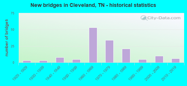
- New bridges - historical statistics
- 31920-1929
- 31930-1939
- 81940-1949
- 51950-1959
- 531960-1969
- 341970-1979
- 211980-1989
- 51990-1999
- 102000-2009
- 62010-2019
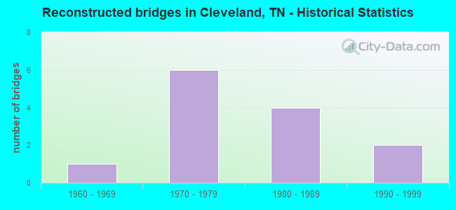
- Reconstructed bridges - Historical Statistics
- 11960-1969
- 61970-1979
- 41980-1989
- 21990-1999
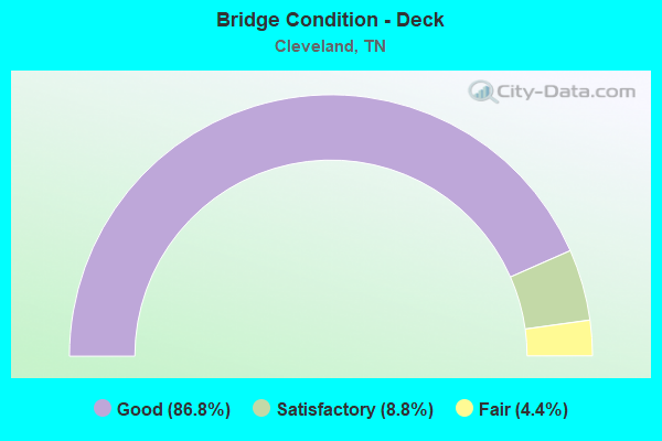
- Bridge Condition - Deck
- 86.8%Good
- 8.8%Satisfactory
- 4.4%Fair
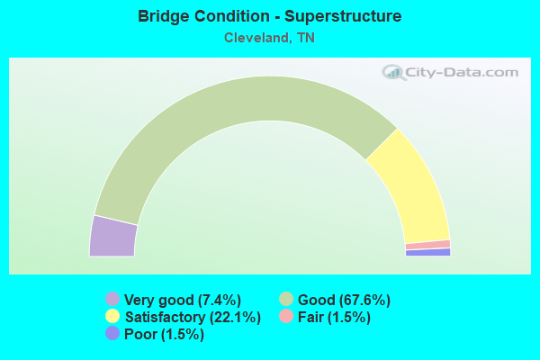
- Bridge Condition - Superstructure
- 7.4%Very good
- 67.6%Good
- 22.1%Satisfactory
- 1.5%Fair
- 1.5%Poor
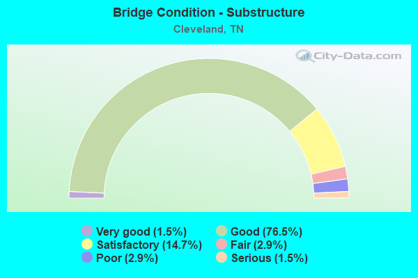
- Bridge Condition - Substructure
- 1.5%Very good
- 76.5%Good
- 14.7%Satisfactory
- 2.9%Fair
- 2.9%Poor
- 1.5%Serious
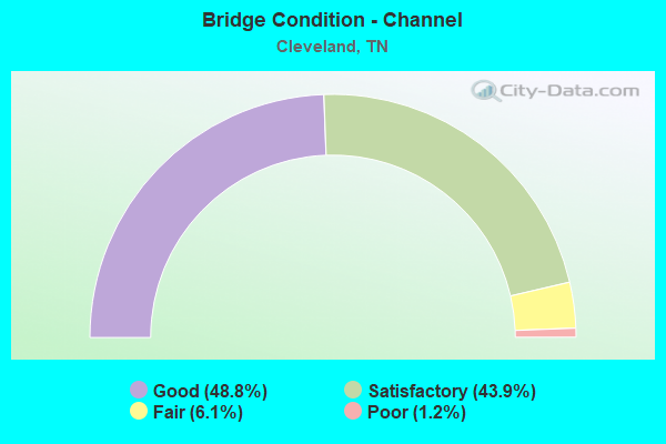
- Bridge Condition - Channel
- 48.8%Good
- 43.9%Satisfactory
- 6.1%Fair
- 1.2%Poor
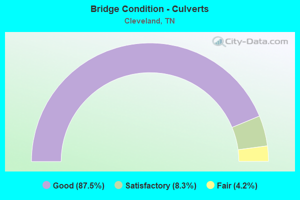
- Bridge Condition - Culverts
- 87.5%Good
- 8.3%Satisfactory
- 4.2%Fair
Find on map >> Show street view
Structure Number: 6SR0020005, Location: 1.2 MI.SW.OF CLEVELAND (Lat: 35.147233, Lng: -84.918000), Route carried "on" structure: US 11, Year Built: 2004, Status: Open, Structure Length: 4.88m (16.01ft), Average Daily Traffic: 9,159 (year 2020), Truck Traffic: 9%, Average Future Daily Traffic: 14,654 (year 2041), Design Load: HS 20, Features Intersected: CANDIES CREEK, Facility Carried by Structure: FAP 2
Minimum Vertical Clearance: 30+ m (98+ ft), Kilometerpoint: 11.040, Lanes on structure: 5, Base Highway Network: Yes, Owner: State Highway Agency, Approaching Roadway Width: 25.6m (84.0ft), Material/Design: Prestressed concrete continuous, Design/Construction: Stringer/Multi-beam, Number Of Spans In Main Unit: 2, Length of Maximum Span: 24.4m (80.1ft), Curb-To-Curb Width: 25.6m (84.0ft), Out-to-Out Width: 26.2m (86.0ft)
Condition: Deck: Good, Superstructure: Very good, Substructure: Good, Channel: Good, Operating Rating: 89.1 metric tons, Method Used To Determine Operating Rating: Load Factor (LF), Inventory Rating: 32.4 metric tons, Method Used To Determine Inventory Rating: Load Factor (LF), Structural Evaluation: Better than present minimum criteria, Deck Geometry: Superior to present desirable criteria, Waterway Adequacy: Superior to present desirable criteria, Approach Roadway Alignment: Equal to present desirable criteria, Designated Inspection Frequency: Every 24 months, Inspection Date: July 2021, Deck Structure Type: Concrete Cast-file-Place, Wearing Surface/Protective System: Wearing Surface: Monolithic Concrete, Deck Protection: Epoxy Coated Reinforcing
Find on map >> Show street view
Structure Number: 6SR0020007, Location: 0.04 MI. E OF SR-2 JCT. (Lat: 35.157967, Lng: -84.885017), Route carried "on" structure: US 11, Year Built: 2004, Status: Open, Structure Length: 0.77m (2.53ft), Average Daily Traffic: 5,979 (year 2020), Truck Traffic: 4%, Average Future Daily Traffic: 9,566 (year 2041), Design Load: HS 20, Features Intersected: SOUTH MOUSE CREEK, Facility Carried by Structure: FAU 40
Minimum Vertical Clearance: 30+ m (98+ ft), Kilometerpoint: 0.064, Lanes on structure: 4, Owner: State Highway Agency, Approaching Roadway Width: 18.3m (60.0ft), Material/Design: Concrete, Design/Construction: Culvert, Number Of Spans In Main Unit: 1, Length of Maximum Span: 7.7m (25.3ft)
Condition: Channel: Good, Culverts: Good, Operating Rating: 54.0 metric tons, Method Used To Determine Operating Rating: Field evaluation and documented engineering judgment, Inventory Rating: 32.4 metric tons, Method Used To Determine Inventory Rating: Field evaluation and documented engineering judgment, Structural Evaluation: Better than present minimum criteria, Waterway Adequacy: Better than present minimum criteria, Approach Roadway Alignment: Equal to present desirable criteria, Designated Inspection Frequency: Every 24 months, Inspection Date: July 2021
Find on map >> Show street view
Structure Number: 6SR0020009, Location: IN CLEVELAND CITY LIMITS (Lat: 35.158100, Lng: -84.878633), Route carried "on" structure: US 11, Year Built: 1925, Status: Posted for load, Structure Length: 0.70m (2.30ft), Average Daily Traffic: 5,979 (year 2020), Truck Traffic: 4%, Average Future Daily Traffic: 9,566 (year 2041), Design Load: H 15, Features Intersected: LITTLE SOUTH MOUSE CREEK, Facility Carried by Structure: FAU 40
Minimum Vertical Clearance: 30+ m (98+ ft), Kilometerpoint: 0.724, Lanes on structure: 2, Owner: State Highway Agency, Approaching Roadway Width: 8.5m (27.9ft), Material/Design: Concrete, Design/Construction: Slab, Number Of Spans In Main Unit: 1, Length of Maximum Span: 7.0m (23.0ft), Curb or Sidewalk Widths: Left: 0.0m, Right: 1.2m (3.9ft), Curb-To-Curb Width: 9.1m (29.9ft), Out-to-Out Width: 11.0m (36.1ft)
Condition: Deck: Fair, Superstructure: Satisfactory, Substructure: Satisfactory, Channel: Good, Operating Rating: 36.0 metric tons, Method Used To Determine Operating Rating: Field evaluation and documented engineering judgment, Inventory Rating: 24.3 metric tons, Method Used To Determine Inventory Rating: Field evaluation and documented engineering judgment, Structural Evaluation: Equal to present minimum criteria, Deck Geometry: High priority of corrective action, Waterway Adequacy: Equal to present minimum criteria, Approach Roadway Alignment: Equal to present desirable criteria, Length Of Structure Improvement: 0.70m (2.30ft), Designated Inspection Frequency: Every 24 months, Inspection Date: July 2021, Bridge Improvement Cost: $99,000, Roadway Improvement Cost: $10,000, Total Project Cost: $149,000 ( Estimate for 2021), Deck Structure Type: Concrete Cast-file-Place, Wearing Surface/Protective System: Wearing Surface: Bituminous
Find on map >> Show street view
Structure Number: 6SR0020011, Location: IN CLEVELAND CITY LIMITS (Lat: 35.191067, Lng: -84.851533), Route carried "on" structure: US 11, Year Built: 1925, Year Reconstructed: 1995, Status: Posted for load, Structure Length: 1.13m (3.71ft), Average Daily Traffic: 9,740 (year 2020), Truck Traffic: 4%, Average Future Daily Traffic: 15,584 (year 2042), Design Load: H 15, Features Intersected: FILLAUERS BRANCH, Facility Carried by Structure: FAS 74
Minimum Vertical Clearance: 30+ m (98+ ft), Kilometerpoint: 26.586, Lanes on structure: 3, Owner: State Highway Agency, Approaching Roadway Width: 7.3m (24.0ft), Skew: 3 degrees, Material/Design: Concrete, Design/Construction: Tee Beam, Number Of Spans In Main Unit: 2, Length of Maximum Span: 5.8m (19.0ft), Curb or Sidewalk Widths: Left: 1.6m (5.2ft), Right: 1.2m (3.9ft), Curb-To-Curb Width: 14.3m (46.9ft), Out-to-Out Width: 17.5m (57.4ft)
Condition: Deck: Good, Superstructure: Good, Substructure: Good, Channel: Satisfactory, Operating Rating: 23.3 metric tons, Method Used To Determine Operating Rating: Load and Resistance Factor Rating (LRFR) rating reported by rating factor(RF) method using HL-93 loadings, Inventory Rating: 18.1 metric tons, Method Used To Determine Inventory Rating: Load and Resistance Factor Rating (LRFR) rating reported by rating factor(RF) method using HL-93 loadings, Structural Evaluation: Meets minimum limits, Deck Geometry: Somewhat better than minimum adequacy, Waterway Adequacy: Better than present minimum criteria, Approach Roadway Alignment: Equal to present desirable criteria, Designated Inspection Frequency: Every 24 months, Inspection Date: August 2021, Deck Structure Type: Concrete Cast-file-Place, Wearing Surface/Protective System: Wearing Surface: Bituminous
Find on map >> Show street view
Structure Number: 6SR0020013, Location: .6 MI.N.OF CLEVELAND (Lat: 35.208767, Lng: -84.837350), Route carried "on" structure: US 11, Year Built: 2001, Status: Open, Structure Length: 0.68m (2.23ft), Average Daily Traffic: 7,947 (year 2020), Truck Traffic: 9%, Average Future Daily Traffic: 12,715 (year 2041), Design Load: HS 20, Features Intersected: BRANCH, Facility Carried by Structure: FAP 2
Minimum Vertical Clearance: 30+ m (98+ ft), Kilometerpoint: 21.758, Lanes on structure: 5, Base Highway Network: Yes, Owner: State Highway Agency, Approaching Roadway Width: 11.0m (36.1ft), Skew: 1 degrees, Material/Design: Concrete continuous, Design/Construction: Culvert, Number Of Spans In Main Unit: 2, Length of Maximum Span: 3.0m (9.8ft)
Condition: Channel: Good, Culverts: Good, Operating Rating: 89.1 metric tons, Method Used To Determine Operating Rating: Load Factor (LF), Inventory Rating: 32.4 metric tons, Method Used To Determine Inventory Rating: Load Factor (LF), Structural Evaluation: Better than present minimum criteria, Waterway Adequacy: Equal to present desirable criteria, Approach Roadway Alignment: Equal to present desirable criteria, Designated Inspection Frequency: Every 24 months, Inspection Date: July 2021
Find on map >> Show street view
Structure Number: 6SR0023001, Location: IN CLEVELAND CITY LIMITS (Lat: 35.189833, Lng: -84.866417), Route carried "on" structure: US 11, Year Built: 1960, Status: Open, Structure Length: 2.62m (8.60ft), Average Daily Traffic: 18,835 (year 2020), Truck Traffic: 9%, Average Future Daily Traffic: 30,136 (year 2041), Design Load: H 15, Features Intersected: SOUTH MOUSE CREEK, Facility Carried by Structure: FAP 2
Minimum Vertical Clearance: 30+ m (98+ ft), Kilometerpoint: 18.330, Lanes on structure: 2, Base Highway Network: Yes, Owner: State Highway Agency, Approaching Roadway Width: 12.2m (40.0ft), Skew: 14 degrees, Material/Design: Concrete, Design/Construction: Tee Beam, Number Of Spans In Main Unit: 3, Length of Maximum Span: 8.8m (28.9ft), Curb-To-Curb Width: 8.5m (27.9ft), Out-to-Out Width: 10.5m (34.4ft)
Condition: Deck: Good, Superstructure: Good, Substructure: Good, Channel: Good, Operating Rating: 63.0 metric tons, Method Used To Determine Operating Rating: Load Factor (LF), Inventory Rating: 32.4 metric tons, Method Used To Determine Inventory Rating: Load Factor (LF), Structural Evaluation: Better than present minimum criteria, Deck Geometry: High priority of corrective action, Waterway Adequacy: Better than present minimum criteria, Approach Roadway Alignment: Equal to present desirable criteria, Length Of Structure Improvement: 2.62m (8.60ft), Designated Inspection Frequency: Every 24 months, Inspection Date: July 2021, Bridge Improvement Cost: $213,000, Roadway Improvement Cost: $22,000, Total Project Cost: $320,000 ( Estimate for 2021), Deck Structure Type: Concrete Cast-file-Place, Wearing Surface/Protective System: Wearing Surface: Bituminous
Find on map >> Show street view
Structure Number: 6SR0023002, Location: IN CLEVELAND CITY LIMITS (Lat: 35.190067, Lng: -84.866350), Route carried "on" structure: US 11, Year Built: 1960, Status: Open, Structure Length: 2.62m (8.60ft), Average Daily Traffic: 18,835 (year 2020), Truck Traffic: 9%, Average Future Daily Traffic: 30,136 (year 2041), Design Load: HS 20, Features Intersected: SOUTH MOUSE CREEK, Facility Carried by Structure: FAP 2
Minimum Vertical Clearance: 30+ m (98+ ft), Kilometerpoint: 18.330, Lanes on structure: 2, Base Highway Network: Yes, Owner: State Highway Agency, Approaching Roadway Width: 12.2m (40.0ft), Skew: 14 degrees, Material/Design: Concrete, Design/Construction: Tee Beam, Number Of Spans In Main Unit: 3, Length of Maximum Span: 8.8m (28.9ft), Curb-To-Curb Width: 8.5m (27.9ft), Out-to-Out Width: 10.5m (34.4ft)
Condition: Deck: Good, Superstructure: Good, Substructure: Good, Channel: Good, Operating Rating: 61.2 metric tons, Method Used To Determine Operating Rating: Load Factor (LF), Inventory Rating: 32.4 metric tons, Method Used To Determine Inventory Rating: Load Factor (LF), Structural Evaluation: Better than present minimum criteria, Deck Geometry: High priority of corrective action, Waterway Adequacy: Better than present minimum criteria, Approach Roadway Alignment: Equal to present desirable criteria, Length Of Structure Improvement: 2.62m (8.60ft), Designated Inspection Frequency: Every 24 months, Inspection Date: July 2021, Bridge Improvement Cost: $213,000, Roadway Improvement Cost: $22,000, Total Project Cost: $320,000 ( Estimate for 2021), Deck Structure Type: Concrete Cast-file-Place, Wearing Surface/Protective System: Wearing Surface: Bituminous
Find on map >> Show street view
Structure Number: 6SR0400005, Location: 4 MI FROM POLK CO LINE (Lat: 35.132900, Lng: -84.749067), Route carried "on" structure: US 64, Year Built: 1971, Status: Open, Structure Length: 1.16m (3.81ft), Average Daily Traffic: 13,475 (year 2020), Truck Traffic: 9%, Average Future Daily Traffic: 21,560 (year 2041), Design Load: H 20, Features Intersected: LONDON BRANCH, Facility Carried by Structure: FAP 402 (SR 40)
Minimum Vertical Clearance: 30+ m (98+ ft), Kilometerpoint: 13.164, Lanes on structure: 2, Base Highway Network: Yes, Owner: State Highway Agency, Approaching Roadway Width: 12.8m (42.0ft), Skew: 3 degrees, Material/Design: Concrete continuous, Design/Construction: Culvert, Number Of Spans In Main Unit: 3, Length of Maximum Span: 3.0m (9.8ft)
Condition: Channel: Satisfactory, Culverts: Good, Operating Rating: 89.1 metric tons, Method Used To Determine Operating Rating: Load Factor (LF), Inventory Rating: 32.4 metric tons, Method Used To Determine Inventory Rating: Load Factor (LF), Structural Evaluation: Better than present minimum criteria, Waterway Adequacy: Equal to present desirable criteria, Approach Roadway Alignment: Equal to present desirable criteria, Designated Inspection Frequency: Every 24 months, Inspection Date: July 2021
Find on map >> Show street view
Structure Number: 6SR0404001, Location: 1 MI. EAST OFI-75 (Lat: 35.145883, Lng: -84.928817), Route carried "on" structure: County highway 60, Year Built: 1965, Status: Open, Structure Length: 7.19m (23.59ft), Average Daily Traffic: 260 (year 2022), Truck Traffic: 2%, Average Future Daily Traffic: 416 (year 2041), Design Load: H 15, Features Intersected: SR 311
Minimum Vertical Clearance: 30+ m (98+ ft), Kilometerpoint: 0.885, Lanes on structure: 2, Lanes under structure: 4, Owner: State Highway Agency, Approaching Roadway Width: 7.9m (25.9ft), Material/Design: Concrete continuous, Design/Construction: Tee Beam, Number Of Spans In Main Unit: 4, Length of Maximum Span: 21.0m (68.9ft), Curb-To-Curb Width: 7.3m (24.0ft), Out-to-Out Width: 8.7m (28.5ft)
Condition: Deck: Good, Superstructure: Good, Substructure: Good, Operating Rating: 47.7 metric tons, Method Used To Determine Operating Rating: Allowable Stress (AS), Inventory Rating: 28.8 metric tons, Method Used To Determine Inventory Rating: Allowable Stress (AS), Structural Evaluation: Better than present minimum criteria, Deck Geometry: Somewhat better than minimum adequacy, Underclear: Somewhat better than minimum adequacy, Approach Roadway Alignment: Equal to present desirable criteria, Designated Inspection Frequency: Every 24 months, Inspection Date: August 2021, Deck Structure Type: Concrete Cast-file-Place, Wearing Surface/Protective System: Wearing Surface: Monolithic Concrete
Find on map >> Show street view
Structure Number: 6SR0404003, Location: 1.8 MI.W.OF CLEVELAND (Lat: 35.141500, Lng: -84.919350), Route carried "on" structure: Bypass US 64, Year Built: 1972, Status: Open, Structure Length: 9.11m (29.89ft), Average Daily Traffic: 21,590 (year 2020), Truck Traffic: 13%, Average Future Daily Traffic: 34,544 (year 2042), Design Load: HS 20, Features Intersected: CANDIES CREEK, Facility Carried by Structure: FAP 311
Minimum Vertical Clearance: 30+ m (98+ ft), Kilometerpoint: 2.849, Lanes on structure: 4, Base Highway Network: Yes, Owner: State Highway Agency, Approaching Roadway Width: 29.9m (98.1ft), Skew: 3 degrees, Material/Design: Prestressed concrete continuous, Design/Construction: Stringer/Multi-beam, Number Of Spans In Main Unit: 4, Length of Maximum Span: 22.6m (74.1ft), Curb-To-Curb Width: 32.9m (107.9ft), Out-to-Out Width: 33.5m (109.9ft)
Condition: Deck: Good, Superstructure: Good, Substructure: Satisfactory, Channel: Satisfactory, Operating Rating: 48.6 metric tons, Method Used To Determine Operating Rating: Load Factor (LF), Inventory Rating: 29.7 metric tons, Method Used To Determine Inventory Rating: Load Factor (LF), Structural Evaluation: Equal to present minimum criteria, Deck Geometry: Superior to present desirable criteria, Waterway Adequacy: Superior to present desirable criteria, Approach Roadway Alignment: Equal to present desirable criteria, Designated Inspection Frequency: Every 24 months, Inspection Date: August 2021, Deck Structure Type: Concrete Cast-file-Place, Wearing Surface/Protective System: Wearing Surface: Bituminous
Find on map >> Show street view
Structure Number: 6SR0404005, Location: .4 MI.W.OF CLEVELAND (Lat: 35.133750, Lng: -84.897150), Route carried "on" structure: Bypass US 64, Year Built: 1972, Status: Open, Structure Length: 5.30m (17.39ft), Average Daily Traffic: 21,590 (year 2020), Truck Traffic: 13%, Average Future Daily Traffic: 34,544 (year 2042), Design Load: HS 20, Features Intersected: NORFOLK-SOUTHERN RWY
Minimum Vertical Clearance: 30+ m (98+ ft), Kilometerpoint: 5.069, Lanes on structure: 4, Base Highway Network: Yes, Owner: State Highway Agency, Approaching Roadway Width: 29.9m (98.1ft), Skew: 22 degrees, Material/Design: Prestressed concrete continuous, Design/Construction: Stringer/Multi-beam, Number Of Spans In Main Unit: 3, Length of Maximum Span: 18.3m (60.0ft), Curb-To-Curb Width: 31.1m (102.0ft), Out-to-Out Width: 31.7m (104.0ft)
Condition: Deck: Good, Superstructure: Good, Substructure: Good, Operating Rating: 50.4 metric tons, Method Used To Determine Operating Rating: Load Factor (LF), Inventory Rating: 29.7 metric tons, Method Used To Determine Inventory Rating: Load Factor (LF), Structural Evaluation: Better than present minimum criteria, Deck Geometry: Superior to present desirable criteria, Underclear: Somewhat better than minimum adequacy, Approach Roadway Alignment: Equal to present desirable criteria, Designated Inspection Frequency: Every 24 months, Inspection Date: August 2021, Deck Structure Type: Concrete Cast-file-Place, Wearing Surface/Protective System: Wearing Surface: Bituminous
Find on map >> Show street view
Structure Number: 6SR0404007, Location: .34 MI.W.OF CLEVELAND (Lat: 35.133717, Lng: -84.895900), Route carried "on" structure: Bypass US 64, Year Built: 1972, Status: Open, Structure Length: 6.13m (20.11ft), Average Daily Traffic: 21,590 (year 2020), Truck Traffic: 13%, Average Future Daily Traffic: 34,544 (year 2041), Design Load: HS 20, Features Intersected: OLD CHATTANOOGA PIKE, Facility Carried by Structure: FAP 311
Minimum Vertical Clearance: 30+ m (98+ ft), Kilometerpoint: 5.182, Lanes on structure: 4, Lanes under structure: 2, Base Highway Network: Yes, Owner: State Highway Agency, Approaching Roadway Width: 29.9m (98.1ft), Skew: 22 degrees, Material/Design: Prestressed concrete continuous, Design/Construction: Stringer/Multi-beam, Number Of Spans In Main Unit: 3, Length of Maximum Span: 22.9m (75.1ft), Curb-To-Curb Width: 31.1m (102.0ft), Out-to-Out Width: 31.7m (104.0ft)
Condition: Deck: Good, Superstructure: Good, Substructure: Good, Operating Rating: 47.7 metric tons, Method Used To Determine Operating Rating: Load Factor (LF), Inventory Rating: 28.8 metric tons, Method Used To Determine Inventory Rating: Load Factor (LF), Structural Evaluation: Better than present minimum criteria, Deck Geometry: Superior to present desirable criteria, Underclear: Superior to present desirable criteria, Approach Roadway Alignment: Equal to present desirable criteria, Designated Inspection Frequency: Every 24 months, Inspection Date: August 2021, Deck Structure Type: Concrete Cast-file-Place, Wearing Surface/Protective System: Wearing Surface: Bituminous
Find on map >> Show street view
Structure Number: 6SR0404009, Location: IN CLEVELAND CITY LIMITS (Lat: 35.132700, Lng: -84.889683), Route carried "on" structure: Bypass US 64, Year Built: 1972, Status: Open, Structure Length: 6.00m (19.69ft), Average Daily Traffic: 21,590 (year 2020), Truck Traffic: 13%, Average Future Daily Traffic: 34,544 (year 2041), Design Load: HS 20, Features Intersected: BLUE SPRING RD (NFA 1181, Facility Carried by Structure: FAP 311
Minimum Vertical Clearance: 30+ m (98+ ft), Kilometerpoint: 5.761, Lanes on structure: 4, Lanes under structure: 2, Base Highway Network: Yes, Owner: State Highway Agency, Approaching Roadway Width: 25.6m (84.0ft), Skew: 20 degrees, Material/Design: Steel continuous, Design/Construction: Stringer/Multi-beam, Number Of Spans In Main Unit: 2, Length of Maximum Span: 32.6m (107.0ft), Curb-To-Curb Width: 26.4m (86.6ft), Out-to-Out Width: 27.4m (89.9ft)
Condition: Deck: Good, Superstructure: Good, Substructure: Good, Operating Rating: 39.6 metric tons, Method Used To Determine Operating Rating: Load Factor (LF), Inventory Rating: 24.3 metric tons, Method Used To Determine Inventory Rating: Load Factor (LF), Structural Evaluation: Equal to present minimum criteria, Deck Geometry: Superior to present desirable criteria, Underclear: Meets minimum limits, Approach Roadway Alignment: Equal to present desirable criteria, Length Of Structure Improvement: 6.00m (19.69ft), Designated Inspection Frequency: Every 24 months, Inspection Date: August 2021, Bridge Improvement Cost: $2,664,000, Roadway Improvement Cost: $267,000, Total Project Cost: $3,997,000 ( Estimate for 2021), Deck Structure Type: Concrete Cast-file-Place, Wearing Surface/Protective System: Wearing Surface: Bituminous
Find on map >> Show street view
Structure Number: 6SR0404011, Location: IN CLEVELAND CITY LIMITS (Lat: 35.131483, Lng: -84.886133), Route carried "on" structure: Business US 64, Year Built: 1972, Status: Open, Structure Length: 0.85m (2.79ft), Average Daily Traffic: 27,128 (year 2020), Truck Traffic: 9%, Average Future Daily Traffic: 43,405 (year 2041), Design Load: HS 20, Features Intersected: BRANCH, Facility Carried by Structure: FAP 311
Minimum Vertical Clearance: 30+ m (98+ ft), Kilometerpoint: 6.116, Lanes on structure: 4, Base Highway Network: Yes, Owner: State Highway Agency, Approaching Roadway Width: 25.6m (84.0ft), Skew: 21 degrees, Material/Design: Concrete continuous, Design/Construction: Culvert, Number Of Spans In Main Unit: 2, Length of Maximum Span: 3.0m (9.8ft)
Condition: Channel: Satisfactory, Culverts: Good, Operating Rating: 54.0 metric tons, Method Used To Determine Operating Rating: Field evaluation and documented engineering judgment, Inventory Rating: 32.4 metric tons, Method Used To Determine Inventory Rating: Field evaluation and documented engineering judgment, Structural Evaluation: Better than present minimum criteria, Waterway Adequacy: Equal to present desirable criteria, Approach Roadway Alignment: Equal to present desirable criteria, Length Of Structure Improvement: 0.85m (2.79ft), Designated Inspection Frequency: Every 24 months, Inspection Date: August 2021, Bridge Improvement Cost: $291,000, Roadway Improvement Cost: $30,000, Total Project Cost: $437,000 ( Estimate for 2021)
Find on map >> Show street view
Structure Number: 6SR0404013, Location: IN CLEVELAND CITY LIMITS (Lat: 35.131617, Lng: -84.885733), Route carried "on" structure: Bypass US 64, Year Built: 1972, Status: Open, Structure Length: 4.63m (15.19ft), Average Daily Traffic: 27,128 (year 2020), Truck Traffic: 9%, Average Future Daily Traffic: 43,405 (year 2042), Design Load: HS 20, Features Intersected: SOUTHERN RAILWAY, Facility Carried by Structure: FAP 311 719639W
Minimum Vertical Clearance: 30+ m (98+ ft), Kilometerpoint: 6.148, Lanes on structure: 4, Base Highway Network: Yes, Owner: State Highway Agency, Approaching Roadway Width: 25.6m (84.0ft), Skew: 20 degrees, Material/Design: Prestressed concrete continuous, Design/Construction: Stringer/Multi-beam, Number Of Spans In Main Unit: 3, Length of Maximum Span: 15.5m (50.9ft), Curb-To-Curb Width: 26.5m (86.9ft), Out-to-Out Width: 27.4m (89.9ft)
Condition: Deck: Good, Superstructure: Good, Substructure: Good, Operating Rating: 54.9 metric tons, Method Used To Determine Operating Rating: Load Factor (LF), Inventory Rating: 32.4 metric tons, Method Used To Determine Inventory Rating: Load Factor (LF), Structural Evaluation: Better than present minimum criteria, Deck Geometry: Superior to present desirable criteria, Underclear: Better than present minimum criteria, Approach Roadway Alignment: Equal to present desirable criteria, Designated Inspection Frequency: Every 24 months, Inspection Date: August 2021, Deck Structure Type: Concrete Cast-file-Place, Wearing Surface/Protective System: Wearing Surface: Bituminous
Find on map >> Show street view
Structure Number: 6SR0404015, Location: IN CLEVELAND CITY LIMITS (Lat: 35.130883, Lng: -84.869350), Route carried "on" structure: Bypass US 64, Year Built: 1972, Status: Open, Structure Length: 7.74m (25.39ft), Average Daily Traffic: 27,128 (year 2020), Truck Traffic: 9%, Average Future Daily Traffic: 43,405 (year 2041), Design Load: HS 20, Features Intersected: SR 311(FAP)/SR 311(FAU), Facility Carried by Structure: FAP 311
Minimum Vertical Clearance: 30+ m (98+ ft), Kilometerpoint: 7.628, Lanes on structure: 4, Lanes under structure: 2, Base Highway Network: Yes, Owner: State Highway Agency, Approaching Roadway Width: 29.9m (98.1ft), Skew: 24 degrees, Material/Design: Steel continuous, Design/Construction: Stringer/Multi-beam, Number Of Spans In Main Unit: 3, Length of Maximum Span: 36.6m (120.1ft), Curb-To-Curb Width: 31.1m (102.0ft), Out-to-Out Width: 31.7m (104.0ft)
Condition: Deck: Good, Superstructure: Good, Substructure: Good, Operating Rating: 57.6 metric tons, Method Used To Determine Operating Rating: Load Factor (LF), Inventory Rating: 32.4 metric tons, Method Used To Determine Inventory Rating: Load Factor (LF), Structural Evaluation: Better than present minimum criteria, Deck Geometry: Superior to present desirable criteria, Underclear: Better than present minimum criteria, Approach Roadway Alignment: Equal to present desirable criteria, Designated Inspection Frequency: Every 24 months, Inspection Date: August 2021, Deck Structure Type: Concrete Cast-file-Place, Wearing Surface/Protective System: Wearing Surface: Monolithic Concrete
Find on map >> Show street view
Structure Number: 6SR0404017, Location: IN CLEVELAND (Lat: 35.133033, Lng: -84.860217), Route carried "on" structure: Bypass US 64, Year Built: 1972, Status: Open, Structure Length: 6.83m (22.41ft), Average Daily Traffic: 28,983 (year 2020), Truck Traffic: 9%, Average Future Daily Traffic: 46,373 (year 2041), Design Load: HS 20, Features Intersected: SR 60 / SR 74, Facility Carried by Structure: FAP 60
Minimum Vertical Clearance: 30+ m (98+ ft), Kilometerpoint: 18.170, Lanes on structure: 4, Lanes under structure: 4, Base Highway Network: Yes, Owner: State Highway Agency, Approaching Roadway Width: 31.7m (104.0ft), Skew: 21 degrees, Material/Design: Steel continuous, Design/Construction: Stringer/Multi-beam, Number Of Spans In Main Unit: 2, Length of Maximum Span: 36.9m (121.1ft), Curb-To-Curb Width: 31.1m (102.0ft), Out-to-Out Width: 31.7m (104.0ft)
Condition: Deck: Good, Superstructure: Good, Substructure: Good, Operating Rating: 49.5 metric tons, Method Used To Determine Operating Rating: Load Factor (LF), Inventory Rating: 29.7 metric tons, Method Used To Determine Inventory Rating: Load Factor (LF), Structural Evaluation: Better than present minimum criteria, Deck Geometry: Superior to present desirable criteria, Underclear: Better than present minimum criteria, Approach Roadway Alignment: Equal to present desirable criteria, Designated Inspection Frequency: Every 24 months, Inspection Date: July 2021, Deck Structure Type: Concrete Cast-file-Place, Wearing Surface/Protective System: Wearing Surface: Bituminous
Find on map >> Show street view
Structure Number: 6SR0404019, Location: IN CLEVELAND CITY LIMITS (Lat: 35.146733, Lng: -84.849883), Route carried "on" structure: Bypass US 64, Year Built: 1974, Status: Open, Structure Length: 4.36m (14.30ft), Average Daily Traffic: 31,707 (year 2020), Truck Traffic: 13%, Average Future Daily Traffic: 50,731 (year 2042), Design Load: HS 20, Features Intersected: BATES PIKE (NFA A712), Facility Carried by Structure: FAP 60
Minimum Vertical Clearance: 30+ m (98+ ft), Kilometerpoint: 19.956, Lanes on structure: 4, Lanes under structure: 2, Base Highway Network: Yes, Owner: State Highway Agency, Approaching Roadway Width: 40.2m (131.9ft), Skew: 22 degrees, Material/Design: Prestressed concrete continuous, Design/Construction: Box Beam or Girders - Single/Spread, Number Of Spans In Main Unit: 3, Length of Maximum Span: 23.5m (77.1ft), Curb-To-Curb Width: 39.6m (129.9ft), Out-to-Out Width: 40.2m (131.9ft)
Condition: Deck: Good, Superstructure: Good, Substructure: Good, Operating Rating: 49.5 metric tons, Method Used To Determine Operating Rating: Load Factor (LF), Inventory Rating: 29.7 metric tons, Method Used To Determine Inventory Rating: Load Factor (LF), Structural Evaluation: Better than present minimum criteria, Deck Geometry: Superior to present desirable criteria, Underclear: High priority of corrective action, Approach Roadway Alignment: Equal to present desirable criteria, Designated Inspection Frequency: Every 24 months, Inspection Date: July 2021, Deck Structure Type: Concrete Cast-file-Place, Wearing Surface/Protective System: Wearing Surface: Bituminous
Find on map >> Show street view
Structure Number: 6SR0404021, Location: IN CLEVELAND CITY LIMITS (Lat: 35.149533, Lng: -84.847883), Route carried "on" structure: Bypass US 64, Year Built: 1974, Status: Open, Structure Length: 6.10m (20.01ft), Average Daily Traffic: 31,707 (year 2020), Truck Traffic: 13%, Average Future Daily Traffic: 50,731 (year 2041), Design Load: HS 20, Features Intersected: SR 60 / SR 40, Facility Carried by Structure: FAP 60
Minimum Vertical Clearance: 30+ m (98+ ft), Kilometerpoint: 20.326, Lanes on structure: 4, Lanes under structure: 4, Base Highway Network: Yes, Owner: State Highway Agency, Approaching Roadway Width: 36.6m (120.1ft), Skew: 21 degrees, Material/Design: Prestressed concrete continuous, Design/Construction: Box Beam or Girders - Single/Spread, Number Of Spans In Main Unit: 2, Length of Maximum Span: 30.5m (100.1ft), Curb-To-Curb Width: 36.0m (118.1ft), Out-to-Out Width: 36.6m (120.1ft)
Condition: Deck: Good, Superstructure: Satisfactory, Substructure: Good, Operating Rating: 44.1 metric tons, Method Used To Determine Operating Rating: Load Factor (LF), Inventory Rating: 26.1 metric tons, Method Used To Determine Inventory Rating: Load Factor (LF), Structural Evaluation: Equal to present minimum criteria, Deck Geometry: Superior to present desirable criteria, Underclear: Meets minimum limits, Approach Roadway Alignment: Equal to present desirable criteria, Designated Inspection Frequency: Every 24 months, Inspection Date: July 2021, Deck Structure Type: Concrete Cast-file-Place, Wearing Surface/Protective System: Wearing Surface: Bituminous, Membrane: Preformed Fabric
Find on map >> Show street view
Structure Number: 6SR0600003, Location: IN CLEVELAND CITY LIMITS (Lat: 35.182533, Lng: -84.872567), Route carried "on" structure: State highway 60, Year Built: 1960, Year Reconstructed: 1990, Status: Open, Structure Length: 1.62m (5.31ft), Average Daily Traffic: 33,534 (year 2020), Truck Traffic: 9%, Average Future Daily Traffic: 53,654 (year 2041), Design Load: H 15, Features Intersected: SOUTH MOUSE CREEK
Minimum Vertical Clearance: 30+ m (98+ ft), Kilometerpoint: 25.299, Lanes on structure: 7, Base Highway Network: Yes, Owner: State Highway Agency, Approaching Roadway Width: 31.1m (102.0ft), Skew: 1 degrees, Material/Design: Concrete continuous, Design/Construction: Culvert, Number Of Spans In Main Unit: 4, Length of Maximum Span: 3.7m (12.1ft), Curb or Sidewalk Widths: Left: 1.2m (3.9ft), Right: 1.4m (4.6ft), Curb-To-Curb Width: 27.9m (91.5ft), Out-to-Out Width: 31.1m (102.0ft)
Condition: Channel: Satisfactory, Culverts: Good, Operating Rating: 77.4 metric tons, Method Used To Determine Operating Rating: Load Factor (LF), Inventory Rating: 32.4 metric tons, Method Used To Determine Inventory Rating: Load Factor (LF), Structural Evaluation: Better than present minimum criteria, Deck Geometry: Somewhat better than minimum adequacy, Waterway Adequacy: Equal to present desirable criteria, Approach Roadway Alignment: Equal to present desirable criteria, Designated Inspection Frequency: Every 24 months, Inspection Date: July 2021, Deck Structure Type: Concrete Cast-file-Place, Wearing Surface/Protective System: Wearing Surface: Bituminous
Find on map >> Show street view
Structure Number: 6SR0600005, Location: IN HOPEWELL (Lat: 35.216900, Lng: -84.882550), Route carried "on" structure: State highway 60, Year Built: 1948, Status: Open, Structure Length: 13.05m (42.81ft), Average Daily Traffic: 14,724 (year 2020), Truck Traffic: 9%, Average Future Daily Traffic: 23,558 (year 2042), Design Load: H 15, Features Intersected: CANDIES CREEK
Minimum Vertical Clearance: 30+ m (98+ ft), Kilometerpoint: 29.902, Lanes on structure: 2, Base Highway Network: Yes, Owner: State Highway Agency, Approaching Roadway Width: 10.4m (34.1ft), Material/Design: Concrete, Design/Construction: Tee Beam, Number Of Spans In Main Unit: 14, Length of Maximum Span: 13.1m (43.0ft), Curb-To-Curb Width: 7.3m (24.0ft), Out-to-Out Width: 9.2m (30.2ft)
Condition: Deck: Satisfactory, Superstructure: Satisfactory, Substructure: Poor, Channel: Satisfactory, Operating Rating: 28.5 metric tons, Method Used To Determine Operating Rating: Load and Resistance Factor Rating (LRFR) rating reported by rating factor(RF) method using HL-93 loadings, Inventory Rating: 22.0 metric tons, Method Used To Determine Inventory Rating: Load and Resistance Factor Rating (LRFR) rating reported by rating factor(RF) method using HL-93 loadings, Structural Evaluation: Meets minimum limits, Deck Geometry: High priority of replacement, Waterway Adequacy: Equal to present desirable criteria, Approach Roadway Alignment: Equal to present desirable criteria, Length Of Structure Improvement: 13.87m (45.51ft), Designated Inspection Frequency: Every 24 months, Inspection Date: July 2021, Bridge Improvement Cost: $3,653,000, Roadway Improvement Cost: $366,000, Total Project Cost: $5,480,000 ( Estimate for 2022), Deck Structure Type: Concrete Cast-file-Place, Wearing Surface/Protective System: Wearing Surface: Bituminous
Find on map >> Show street view
Structure Number: 6SR0600021, Location: 1.4 MILE N.OF CLEVELAND (Lat: 35.159633, Lng: -84.844900), Route carried "on" structure: State highway 60, Year Built: 1976, Status: Open, Structure Length: 3.23m (10.60ft), Average Daily Traffic: 31,707 (year 2020), Truck Traffic: 13%, Average Future Daily Traffic: 50,731 (year 2041), Design Load: HS 20, Features Intersected: BENTON PIKE (NFA 1154)
Minimum Vertical Clearance: 30+ m (98+ ft), Kilometerpoint: 21.533, Lanes on structure: 2, Lanes under structure: 2, Base Highway Network: Yes, Owner: State Highway Agency, Approaching Roadway Width: 12.8m (42.0ft), Material/Design: Concrete, Design/Construction: Box Beam or Girders - Single/Spread, Number Of Spans In Main Unit: 1, Length of Maximum Span: 32.3m (106.0ft), Curb-To-Curb Width: 12.8m (42.0ft), Out-to-Out Width: 13.4m (44.0ft)
Condition: Deck: Good, Superstructure: Good, Substructure: Good, Operating Rating: 44.1 metric tons, Method Used To Determine Operating Rating: Assigned rating based on Load Factor Design (LFD) reported in metric tons, Inventory Rating: 32.4 metric tons, Method Used To Determine Inventory Rating: Assigned rating based on Load Factor Design (LFD) reported in metric tons, Structural Evaluation: Better than present minimum criteria, Deck Geometry: Equal to present desirable criteria, Underclear: Superior to present desirable criteria, Approach Roadway Alignment: Equal to present desirable criteria, Designated Inspection Frequency: Every 24 months, Inspection Date: July 2021, Deck Structure Type: Concrete Cast-file-Place, Wearing Surface/Protective System: Wearing Surface: Bituminous, Membrane: Preformed Fabric
Find on map >> Show street view
Structure Number: 6SR0600023, Location: IN CLEVELAND CITY LIMITS (Lat: 35.154367, Lng: -84.844583), Route carried "on" structure: State highway 60, Year Built: 1976, Status: Open, Structure Length: 2.80m (9.19ft), Average Daily Traffic: 31,707 (year 2020), Truck Traffic: 13%, Average Future Daily Traffic: 50,731 (year 2041), Design Load: HS 20, Features Intersected: POWER LINE RD. (NFA A706
Minimum Vertical Clearance: 30+ m (98+ ft), Kilometerpoint: 20.938, Lanes on structure: 2, Lanes under structure: 2, Base Highway Network: Yes, Owner: State Highway Agency, Approaching Roadway Width: 12.8m (42.0ft), Skew: 2 degrees, Material/Design: Concrete, Design/Construction: Box Beam or Girders - Single/Spread, Number Of Spans In Main Unit: 1, Length of Maximum Span: 28.0m (91.9ft), Curb-To-Curb Width: 14.3m (46.9ft), Out-to-Out Width: 14.9m (48.9ft)
Condition: Deck: Good, Superstructure: Good, Substructure: Good, Operating Rating: 44.1 metric tons, Method Used To Determine Operating Rating: Assigned rating based on Load Factor Design (LFD) reported in metric tons, Inventory Rating: 32.4 metric tons, Method Used To Determine Inventory Rating: Assigned rating based on Load Factor Design (LFD) reported in metric tons, Structural Evaluation: Better than present minimum criteria, Deck Geometry: Superior to present desirable criteria, Underclear: Better than present minimum criteria, Approach Roadway Alignment: Equal to present desirable criteria, Designated Inspection Frequency: Every 24 months, Inspection Date: July 2021, Deck Structure Type: Concrete Cast-file-Place, Wearing Surface/Protective System: Wearing Surface: Bituminous, Membrane: Preformed Fabric
Find on map >> Show street view
Structure Number: 6SR0600024, Location: IN CLEVELAND CITY LIMITS (Lat: 35.154400, Lng: -84.844800), Route carried "on" structure: State highway 60, Year Built: 1976, Status: Open, Structure Length: 2.80m (9.19ft), Average Daily Traffic: 31,707 (year 2020), Truck Traffic: 13%, Average Future Daily Traffic: 50,731 (year 2041), Design Load: HS 20, Features Intersected: POWER LINE RD. (NFA A706
Minimum Vertical Clearance: 30+ m (98+ ft), Kilometerpoint: 20.938, Lanes on structure: 2, Lanes under structure: 2, Base Highway Network: Yes, Owner: State Highway Agency, Approaching Roadway Width: 12.8m (42.0ft), Skew: 2 degrees, Material/Design: Concrete, Design/Construction: Box Beam or Girders - Single/Spread, Number Of Spans In Main Unit: 1, Length of Maximum Span: 28.0m (91.9ft), Curb-To-Curb Width: 12.8m (42.0ft), Out-to-Out Width: 13.4m (44.0ft)
Condition: Deck: Good, Superstructure: Good, Substructure: Good, Operating Rating: 44.1 metric tons, Method Used To Determine Operating Rating: Assigned rating based on Load Factor Design (LFD) reported in metric tons, Inventory Rating: 32.4 metric tons, Method Used To Determine Inventory Rating: Assigned rating based on Load Factor Design (LFD) reported in metric tons, Structural Evaluation: Better than present minimum criteria, Deck Geometry: Equal to present desirable criteria, Underclear: Equal to present minimum criteria, Approach Roadway Alignment: Equal to present desirable criteria, Designated Inspection Frequency: Every 24 months, Inspection Date: July 2021, Deck Structure Type: Concrete Cast-file-Place, Wearing Surface/Protective System: Wearing Surface: Bituminous, Membrane: Preformed Fabric
Find on map >> Show street view
Structure Number: 6SR0600025, Location: IN CLEVELAND CITY LIMITS (Lat: 35.165717, Lng: -84.847533), Route carried "on" structure: State highway 60, Year Built: 1976, Status: Open, Structure Length: 11.55m (37.89ft), Average Daily Traffic: 28,890 (year 2020), Truck Traffic: 13%, Average Future Daily Traffic: 46,224 (year 2041), Design Load: H 20, Features Intersected: NFA A576-FAU 1156-SOU RW
Minimum Vertical Clearance: 30+ m (98+ ft), Kilometerpoint: 22.257, Lanes on structure: 3, Lanes under structure: 7, Base Highway Network: Yes, Owner: State Highway Agency, Approaching Roadway Width: 12.8m (42.0ft), Material/Design: Steel continuous, Design/Construction: Stringer/Multi-beam, Number Of Spans In Main Unit: 3, Length of Maximum Span: 42.7m (140.1ft), Curb-To-Curb Width: 12.8m (42.0ft), Out-to-Out Width: 13.4m (44.0ft)
Condition: Deck: Good, Superstructure: Good, Substructure: Satisfactory, Operating Rating: 43.2 metric tons, Method Used To Determine Operating Rating: Load Factor (LF), Inventory Rating: 26.1 metric tons, Method Used To Determine Inventory Rating: Load Factor (LF), Structural Evaluation: Equal to present minimum criteria, Deck Geometry: Meets minimum limits, Underclear: Meets minimum limits, Approach Roadway Alignment: Equal to present desirable criteria, Length Of Structure Improvement: 11.55m (37.89ft), Designated Inspection Frequency: Every 24 months, Inspection Date: July 2021, Bridge Improvement Cost: $738,000, Roadway Improvement Cost: $74,000, Total Project Cost: $1,108,000 ( Estimate for 2021), Deck Structure Type: Concrete Cast-file-Place, Wearing Surface/Protective System: Wearing Surface: Bituminous, Membrane: Preformed Fabric
Find on map >> Show street view
Structure Number: 6SR0600026, Location: IN CLEVELAND CITY LIMITS (Lat: 35.165683, Lng: -84.847800), Route carried "on" structure: State highway 60, Year Built: 1976, Status: Open, Structure Length: 11.55m (37.89ft), Average Daily Traffic: 28,890 (year 2020), Truck Traffic: 13%, Average Future Daily Traffic: 46,224 (year 2041), Design Load: H 20, Features Intersected: NFA A576-FAU 3645-SOU RW
Minimum Vertical Clearance: 30+ m (98+ ft), Kilometerpoint: 22.257, Lanes on structure: 3, Lanes under structure: 7, Base Highway Network: Yes, Owner: State Highway Agency, Approaching Roadway Width: 12.8m (42.0ft), Material/Design: Steel continuous, Design/Construction: Stringer/Multi-beam, Number Of Spans In Main Unit: 3, Length of Maximum Span: 42.7m (140.1ft), Curb-To-Curb Width: 12.8m (42.0ft), Out-to-Out Width: 13.4m (44.0ft)
Condition: Deck: Good, Superstructure: Good, Substructure: Satisfactory, Operating Rating: 43.2 metric tons, Method Used To Determine Operating Rating: Load Factor (LF), Inventory Rating: 26.1 metric tons, Method Used To Determine Inventory Rating: Load Factor (LF), Structural Evaluation: Equal to present minimum criteria, Deck Geometry: Meets minimum limits, Underclear: Somewhat better than minimum adequacy, Approach Roadway Alignment: Equal to present desirable criteria, Length Of Structure Improvement: 11.55m (37.89ft), Designated Inspection Frequency: Every 24 months, Inspection Date: July 2021, Bridge Improvement Cost: $738,000, Roadway Improvement Cost: $74,000, Total Project Cost: $1,108,000 ( Estimate for 2021), Deck Structure Type: Concrete Cast-file-Place, Wearing Surface/Protective System: Wearing Surface: Bituminous, Membrane: Preformed Fabric
Find on map >> Show street view
Structure Number: 6SR0600027, Location: CITY OF CLEVELAND (Lat: 35.176550, Lng: -84.861533), Route carried "on" structure: State highway 60, Year Built: 1975, Status: Open, Structure Length: 0.67m (2.20ft), Average Daily Traffic: 23,219 (year 2020), Truck Traffic: 13%, Average Future Daily Traffic: 37,150 (year 2041), Features Intersected: FILLAUER BRANCH
Minimum Vertical Clearance: 30+ m (98+ ft), Kilometerpoint: 24.076, Lanes on structure: 4, Base Highway Network: Yes, Owner: State Highway Agency, Approaching Roadway Width: 14.6m (47.9ft), Skew: 20 degrees, Material/Design: Concrete continuous, Design/Construction: Culvert, Number Of Spans In Main Unit: 2, Length of Maximum Span: 3.0m (9.8ft), Curb or Sidewalk Widths: Left: 1.5m (4.9ft), Right: 1.5m (4.9ft)
Condition: Channel: Good, Culverts: Good, Operating Rating: 64.8 metric tons, Method Used To Determine Operating Rating: Load Factor (LF), Inventory Rating: 32.4 metric tons, Method Used To Determine Inventory Rating: Load Factor (LF), Structural Evaluation: Better than present minimum criteria, Waterway Adequacy: Equal to present desirable criteria, Approach Roadway Alignment: Equal to present desirable criteria, Length Of Structure Improvement: 0.67m (2.20ft), Designated Inspection Frequency: Every 24 months, Inspection Date: July 2021, Bridge Improvement Cost: $253,000, Roadway Improvement Cost: $26,000, Total Project Cost: $380,000 ( Estimate for 2021)
Find on map >> Show street view
Structure Number: 6SR0740001, Location: ON GEORGIA STATE LINE (Lat: 34.988100, Lng: -84.776017), Route carried "on" structure: State highway 74, Year Built: 2011, Status: Open, Structure Length: 5.00m (16.40ft), Average Daily Traffic: 1,709 (year 2020), Truck Traffic: 13%, Average Future Daily Traffic: 2,734 (year 2041), Design Load: HL 93, Features Intersected: OVERFLOW CONASAUGA RIVER
Minimum Vertical Clearance: 30+ m (98+ ft), Kilometerpoint: 0.016, Lanes on structure: 2, Owner: State Highway Agency, Approaching Roadway Width: 10.1m (33.1ft), Material/Design: Prestressed concrete continuous, Design/Construction: Box Beam or Girders - Single/Spread, Number Of Spans In Main Unit: 3, Length of Maximum Span: 30.4m (99.7ft), Curb-To-Curb Width: 9.8m (32.2ft), Out-to-Out Width: 10.1m (33.1ft)
Condition: Deck: Good, Superstructure: Very good, Substructure: Good, Channel: Good, Operating Rating: 44.1 metric tons, Method Used To Determine Operating Rating: Assigned ratings based on Load and Resistance Factor Design (LRFD) reported by rating factor (RF) using HL93 loadings, Inventory Rating: 32.4 metric tons, Method Used To Determine Inventory Rating: Assigned ratings based on Load and Resistance Factor Design (LRFD) reported by rating factor (RF) using HL93 loadings, Structural Evaluation: Better than present minimum criteria, Deck Geometry: Somewhat better than minimum adequacy, Waterway Adequacy: Equal to present desirable criteria, Approach Roadway Alignment: Equal to present desirable criteria, Length Of Structure Improvement: 6.02m (19.75ft), Designated Inspection Frequency: Every 24 months, Inspection Date: August 2021, Bridge Improvement Cost: $1,530,000, Roadway Improvement Cost: $154,000, Total Project Cost: $2,296,000 ( Estimate for 2021), Deck Structure Type: Concrete Cast-file-Place, Wearing Surface/Protective System: Wearing Surface: Monolithic Concrete, Deck Protection: Epoxy Coated Reinforcing
Find on map >> Show street view
Structure Number: 6SR0740011, Location: 1 MI FROM SR40 (Lat: 35.148400, Lng: -84.870150), Route carried "on" structure: US 74, Year Built: 1940, Status: Open, Structure Length: 0.76m (2.49ft), Average Daily Traffic: 9,765 (year 2020), Truck Traffic: 4%, Average Future Daily Traffic: 15,624 (year 2041), Design Load: HS 20, Features Intersected: BRANCH
Minimum Vertical Clearance: 30+ m (98+ ft), Kilometerpoint: 21.324, Lanes on structure: 2, Owner: State Highway Agency, Approaching Roadway Width: 8.5m (27.9ft), Skew: 16 degrees, Material/Design: Concrete, Design/Construction: Culvert, Number Of Spans In Main Unit: 1, Length of Maximum Span: 2.7m (8.9ft), Curb or Sidewalk Widths: Left: 2.0m (6.6ft), Right: 2.2m (7.2ft), Curb-To-Curb Width: 8.5m (27.9ft), Out-to-Out Width: 12.9m (42.3ft)
Condition: Channel: Good, Culverts: Good, Operating Rating: 50.4 metric tons, Method Used To Determine Operating Rating: Load Factor (LF), Inventory Rating: 30.6 metric tons, Method Used To Determine Inventory Rating: Load Factor (LF), Structural Evaluation: Better than present minimum criteria, Deck Geometry: High priority of replacement, Waterway Adequacy: Better than present minimum criteria, Approach Roadway Alignment: Better than present minimum criteria, Length Of Structure Improvement: 0.76m (2.49ft), Designated Inspection Frequency: Every 24 months, Inspection Date: August 2021, Bridge Improvement Cost: $141,000, Roadway Improvement Cost: $15,000, Total Project Cost: $212,000 ( Estimate for 2021), Deck Structure Type: Concrete Cast-file-Place, Wearing Surface/Protective System: Wearing Surface: Bituminous
Find on map >> Show street view
Structure Number: 6SR3110001, Location: 1/2 MI. EAST OFI-75 (Lat: 35.148483, Lng: -84.937350), Route carried "on" structure: County highway 50, Year Built: 2017, Status: Open, Structure Length: 8.02m (26.31ft), Average Daily Traffic: 260 (year 2022), Truck Traffic: 2%, Average Future Daily Traffic: 416 (year 2042), Design Load: HL 93, Features Intersected: SR 311
Minimum Vertical Clearance: 30+ m (98+ ft), Kilometerpoint: 4.788, Lanes on structure: 4, Lanes under structure: 4, Owner: State Highway Agency, Approaching Roadway Width: 22.0m (72.2ft), Skew: 10 degrees, Material/Design: Prestressed concrete continuous, Design/Construction: Stringer/Multi-beam, Number Of Spans In Main Unit: 2, Length of Maximum Span: 40.1m (131.6ft), Curb-To-Curb Width: 29.3m (96.1ft), Out-to-Out Width: 29.7m (97.4ft)
Condition: Deck: Good, Superstructure: Good, Substructure: Good, Operating Rating: 44.1 metric tons, Method Used To Determine Operating Rating: Assigned ratings based on Load and Resistance Factor Design (LRFD) reported by rating factor (RF) using HL93 loadings, Inventory Rating: 32.4 metric tons, Method Used To Determine Inventory Rating: Assigned ratings based on Load and Resistance Factor Design (LRFD) reported by rating factor (RF) using HL93 loadings, Structural Evaluation: Better than present minimum criteria, Deck Geometry: Superior to present desirable criteria, Underclear: Equal to present minimum criteria, Approach Roadway Alignment: Equal to present desirable criteria, Designated Inspection Frequency: Every 24 months, Inspection Date: August 2021, Deck Structure Type: Concrete Cast-file-Place, Wearing Surface/Protective System: Wearing Surface: Bituminous
Find on map >> Show street view
Structure Number: 6SR3110003, Location: 1/2 MI. EAST OFI-75 (Lat: 35.149267, Lng: -84.936050), Route carried "on" structure: Ramp US 64, Year Built: 2017, Status: Open, Structure Length: 3.66m (12.01ft), Average Daily Traffic: 21,054 (year 2020), Truck Traffic: 13%, Average Future Daily Traffic: 33,686 (year 2041), Design Load: HL 93, Features Intersected: COLONIAL PIPELINE, Facility Carried by Structure: SR311 WB RAMP
Minimum Vertical Clearance: 30+ m (98+ ft), Kilometerpoint: 1.110, Lanes on structure: 3, Base Highway Network: Yes, Owner: State Highway Agency, Approaching Roadway Width: 17.1m (56.1ft), Material/Design: Prestressed concrete, Design/Construction: Stringer/Multi-beam, Number Of Spans In Main Unit: 1, Length of Maximum Span: 36.6m (120.1ft), Curb-To-Curb Width: 16.8m (55.1ft), Out-to-Out Width: 17.2m (56.4ft)
Condition: Deck: Good, Superstructure: Good, Substructure: Good, Operating Rating: 44.1 metric tons, Method Used To Determine Operating Rating: Assigned ratings based on Load and Resistance Factor Design (LRFD) reported by rating factor (RF) using HL93 loadings, Inventory Rating: 32.4 metric tons, Method Used To Determine Inventory Rating: Assigned ratings based on Load and Resistance Factor Design (LRFD) reported by rating factor (RF) using HL93 loadings, Structural Evaluation: Better than present minimum criteria, Deck Geometry: Superior to present desirable criteria, Approach Roadway Alignment: Equal to present desirable criteria, Designated Inspection Frequency: Every 24 months, Inspection Date: August 2021, Deck Structure Type: Concrete Cast-file-Place, Wearing Surface/Protective System: Wearing Surface: Monolithic Concrete
Find on map >> Show street view
Structure Number: 6SR3110005, Location: 1/2 MI. EAST OFI-75 (Lat: 35.147933, Lng: -84.937167), Route carried "on" structure: Ramp US 64, Year Built: 2017, Status: Open, Structure Length: 3.69m (12.11ft), Average Daily Traffic: 21,054 (year 2020), Truck Traffic: 13%, Average Future Daily Traffic: 33,686 (year 2041), Design Load: HL 93, Features Intersected: COLONIAL PIPELINE, Facility Carried by Structure: SR311 EB RAMP
Minimum Vertical Clearance: 30+ m (98+ ft), Kilometerpoint: 1.078, Lanes on structure: 2, Base Highway Network: Yes, Owner: State Highway Agency, Approaching Roadway Width: 12.8m (42.0ft), Skew: 1 degrees, Material/Design: Prestressed concrete, Design/Construction: Stringer/Multi-beam, Number Of Spans In Main Unit: 1, Length of Maximum Span: 36.9m (121.1ft), Curb-To-Curb Width: 12.8m (42.0ft), Out-to-Out Width: 13.5m (44.3ft)
Condition: Deck: Good, Superstructure: Good, Substructure: Good, Operating Rating: 44.1 metric tons, Method Used To Determine Operating Rating: Assigned ratings based on Load and Resistance Factor Design (LRFD) reported by rating factor (RF) using HL93 loadings, Inventory Rating: 32.4 metric tons, Method Used To Determine Inventory Rating: Assigned ratings based on Load and Resistance Factor Design (LRFD) reported by rating factor (RF) using HL93 loadings, Structural Evaluation: Better than present minimum criteria, Deck Geometry: Superior to present desirable criteria, Approach Roadway Alignment: Equal to present desirable criteria, Designated Inspection Frequency: Every 24 months, Inspection Date: August 2021, Deck Structure Type: Concrete Cast-file-Place, Wearing Surface/Protective System: Wearing Surface: Monolithic Concrete
Find on map >> Show street view
Structure Number: 6036340001, Location: IN CLEVELAND (Lat: 35.153733, Lng: -84.871733), Route carried "under" structure: City street 3643, Year Built: 1988, Structure Length: 0. m, Average Daily Traffic: 1,746 (year 2020), Truck Traffic: 3%, Features Intersected: PED. WALKWAY, Facility Carried by Structure: PED. WALKWAY
Minimum Vertical Clearance: 4.70m (15.42ft), Kilometerpoint: 0.274, Lanes under structure: 2, Material/Design: Steel, Design/Construction: Stringer/Multi-beam, Length of Maximum Span: 14.6m (47.9ft)
Find on map >> Show street view
Structure Number: 60A9900001, Location: IN CLEVELAND (Lat: 35.151600, Lng: -84.871867), Route carried "under" structure: City street 990, Year Built: 1988, Structure Length: 0. m, Average Daily Traffic: 200 (year 2022), Truck Traffic: 5%, Features Intersected: PED. WALKWAY, Facility Carried by Structure: PED. WALKWAY
Minimum Vertical Clearance: 4.68m (15.35ft), Kilometerpoint: 1.070, Lanes under structure: 2, Material/Design: Steel, Design/Construction: Stringer/Multi-beam, Length of Maximum Span: 16.8m (55.1ft)
Find on map >> Show street view
Structure Number: 6I00750001, Location: 4.5 MI FROM SR 311 (Lat: 35.141783, Lng: -84.985567), Route carried "under" structure: County highway 2261, Year Built: 1963, Structure Length: 0. m, Average Daily Traffic: 1,004 (year 2020), Truck Traffic: 3%, Features Intersected: I75 / BANCROFT RD, Facility Carried by Structure: I75 (SA 0606)
Minimum Vertical Clearance: 4.27m (14.01ft), Kilometerpoint: 4.394, Lanes on structure: 2, Lanes under structure: 2, Material/Design: Concrete continuous, Design/Construction: Tee Beam, Length of Maximum Span: 13.7m (44.9ft)
Find on map >> Show street view
Structure Number: 6I00750002, Location: 4.5 MI FROM SR 311 (Lat: 35.143133, Lng: -84.985417), Route carried "under" structure: County highway 2261, Year Built: 1963, Structure Length: 0. m, Average Daily Traffic: 1,004 (year 2020), Truck Traffic: 3%, Features Intersected: I75 / BANCROFT RD, Facility Carried by Structure: I75 (SA 0606)
Minimum Vertical Clearance: 4.17m (13.68ft), Kilometerpoint: 4.474, Lanes on structure: 2, Lanes under structure: 2, Material/Design: Concrete continuous, Design/Construction: Tee Beam, Length of Maximum Span: 14.0m (45.9ft)
Find on map >> Show street view
Structure Number: 6I00750003, Location: NEAR CLEVELAND TN (Lat: 35.152033, Lng: -84.947567), Route carried "under" structure: Interstate 75, Year Built: 1970, Structure Length: 0. m, Average Daily Traffic: 54,250 (year 2020), Truck Traffic: 27%, Features Intersected: SR 311, Facility Carried by Structure: FAP 311
Minimum Vertical Clearance: 5.56m (18.24ft), Kilometerpoint: 7.805, Lanes on structure: 2, Lanes under structure: 4, Material/Design: Concrete continuous, Design/Construction: Tee Beam, Length of Maximum Span: 24.7m (81.0ft)
Find on map >> Show street view
Structure Number: 6I00750007, Location: 2.8 MI FROM SR 40 (Lat: 35.164817, Lng: -84.930417), Route carried "under" structure: County highway 77, Year Built: 1965, Structure Length: 0. m, Average Daily Traffic: 780 (year 2022), Truck Traffic: 2%, Features Intersected: I75, Facility Carried by Structure: I75
Minimum Vertical Clearance: 5.11m (16.77ft), Kilometerpoint: 3.336, Lanes on structure: 2, Lanes under structure: 2, Material/Design: Prestressed concrete, Design/Construction: Stringer/Multi-beam, Length of Maximum Span: 13.7m (44.9ft)
Find on map >> Show street view
Structure Number: 6I00750008, Location: 2.8 MI FROM SR 40 (Lat: 35.164950, Lng: -84.980733), Route carried "under" structure: County highway 77, Year Built: 1965, Structure Length: 0. m, Average Daily Traffic: 780 (year 2022), Truck Traffic: 2%, Features Intersected: I75, Facility Carried by Structure: I75
Minimum Vertical Clearance: 4.35m (14.27ft), Kilometerpoint: 3.299, Lanes on structure: 2, Lanes under structure: 2, Material/Design: Prestressed concrete, Design/Construction: Stringer/Multi-beam, Length of Maximum Span: 13.7m (44.9ft)
Find on map >> Show street view
Structure Number: 6I00750011, Location: NEAR CLEVELAND TN (Lat: 35.176050, Lng: -84.916733), Route carried "under" structure: Interstate 75, Year Built: 1965, Structure Length: 0. m, Average Daily Traffic: 47,898 (year 2020), Truck Traffic: 27%, Features Intersected: SR 312 / I75, Facility Carried by Structure: FAS 312
Minimum Vertical Clearance: 5.21m (17.09ft), Kilometerpoint: 11.716, Lanes on structure: 2, Lanes under structure: 4, Material/Design: Concrete continuous, Design/Construction: Tee Beam, Length of Maximum Span: 21.0m (68.9ft)
Find on map >> Show street view
Structure Number: 6I00750017, Location: IN CLEVELAND CITY LIMITS (Lat: 35.194000, Lng: -84.887033), Route carried "under" structure: State highway 60, Year Built: 1965, Structure Length: 0. m, Average Daily Traffic: 25,106 (year 2020), Truck Traffic: 9%, Features Intersected: I75 / SR 60, Facility Carried by Structure: I75
Minimum Vertical Clearance: 4.65m (15.26ft), Kilometerpoint: 27.134, Lanes on structure: 2, Lanes under structure: 4, Material/Design: Concrete continuous, Design/Construction: Tee Beam, Length of Maximum Span: 15.5m (50.9ft)
Find on map >> Show street view
Structure Number: 6I00750018, Location: IN CLEVELAND CITY LIMITS (Lat: 35.194233, Lng: -84.887183), Route carried "under" structure: State highway 60, Year Built: 1965, Structure Length: 0. m, Average Daily Traffic: 12,524 (year 2020), Truck Traffic: 9%, Features Intersected: I75 / SR 60, Facility Carried by Structure: I75
Minimum Vertical Clearance: 5.51m (18.08ft), Kilometerpoint: 27.166, Lanes on structure: 2, Lanes under structure: 4, Material/Design: Concrete continuous, Design/Construction: Tee Beam, Length of Maximum Span: 15.5m (50.9ft)
Find on map >> Show street view
Structure Number: 6I00750019, Location: IN CLEVELAND (Lat: 35.198883, Lng: -84.877433), Route carried "under" structure: City street 3660, Year Built: 1964, Structure Length: 0. m, Average Daily Traffic: 4,359 (year 2020), Truck Traffic: 3%, Features Intersected: I75, Facility Carried by Structure: I75
Minimum Vertical Clearance: 5.28m (17.32ft), Kilometerpoint: 4.941, Lanes on structure: 2, Lanes under structure: 2, Material/Design: Concrete continuous, Design/Construction: Tee Beam, Length of Maximum Span: 14.3m (46.9ft)
Find on map >> Show street view
Structure Number: 6I0075002, Location: IN CITY OF CLEVELAND (Lat: 35.199067, Lng: -84.877783), Route carried "under" structure: City street 3660, Year Built: 1964, Structure Length: 0. m, Average Daily Traffic: 4,359 (year 2020), Truck Traffic: 3%, Features Intersected: I75, Facility Carried by Structure: I75
Minimum Vertical Clearance: 5.05m (16.57ft), Kilometerpoint: 4.909, Lanes on structure: 2, Lanes under structure: 2, Material/Design: Concrete continuous, Design/Construction: Tee Beam, Length of Maximum Span: 14.3m (46.9ft)
Find on map >> Show street view
Structure Number: 6I00750021, Location: IN CITY OF CLEVELAND (Lat: 35.212600, Lng: -84.866417), Route carried "under" structure: City street 3660, Year Built: 1968, Structure Length: 0. m, Average Daily Traffic: 18,036 (year 2020), Truck Traffic: 9%, Features Intersected: I75, Facility Carried by Structure: I75
Minimum Vertical Clearance: 4.44m (14.57ft), Kilometerpoint: 2.639, Lanes on structure: 2, Lanes under structure: 5, Material/Design: Prestressed concrete continuous, Design/Construction: Stringer/Multi-beam, Length of Maximum Span: 19.2m (63.0ft)
Find on map >> Show street view
Structure Number: 6I00750022, Location: IN THE CITY OF CLEVELAND (Lat: 35.212733, Lng: -84.866700), Route carried "under" structure: City street 3660, Year Built: 1968, Structure Length: 0. m, Average Daily Traffic: 18,036 (year 2020), Truck Traffic: 9%, Features Intersected: I75, Facility Carried by Structure: I75
Minimum Vertical Clearance: 4.80m (15.75ft), Kilometerpoint: 2.672, Lanes on structure: 2, Lanes under structure: 5, Material/Design: Prestressed concrete continuous, Design/Construction: Frame, Length of Maximum Span: 19.2m (63.0ft)
Find on map >> Show street view
Structure Number: 6I00750023, Location: 11.23 MI N OF CLEVLAND (Lat: 35.254567, Lng: -84.836217), Route carried "under" structure: County highway 164, Year Built: 1968, Structure Length: 0. m, Average Daily Traffic: 450 (year 2022), Truck Traffic: 2%, Features Intersected: I75, Facility Carried by Structure: I75
Minimum Vertical Clearance: 4.32m (14.17ft), Kilometerpoint: 0.295, Lanes on structure: 2, Lanes under structure: 2, Material/Design: Prestressed concrete continuous, Design/Construction: Stringer/Multi-beam, Length of Maximum Span: 18.9m (62.0ft)
Find on map >> Show street view
Structure Number: 6I00750024, Location: 11.23 MI FR CITY BOUNDARY (Lat: 35.255217, Lng: -84.837200), Route carried "under" structure: County highway 164, Year Built: 1968, Structure Length: 0. m, Average Daily Traffic: 450 (year 2022), Truck Traffic: 2%, Features Intersected: I75, Facility Carried by Structure: I75
Minimum Vertical Clearance: 4.37m (14.34ft), Kilometerpoint: 0.414, Lanes on structure: 2, Lanes under structure: 2, Material/Design: Prestressed concrete continuous, Design/Construction: Stringer/Multi-beam, Length of Maximum Span: 20.1m (65.9ft)
Find on map >> Show street view
Structure Number: 6SR0020003, Location: NEAR CLEVELAND TN (Lat: 35.143167, Lng: -84.923433), Route carried "under" structure: State highway 2, Year Built: 1972, Structure Length: 0. m, Average Daily Traffic: 7,009 (year 2020), Truck Traffic: 4%, Features Intersected: SR 311, Facility Carried by Structure: FAP 311
Minimum Vertical Clearance: 4.80m (15.75ft), Kilometerpoint: 10.364, Lanes on structure: 4, Lanes under structure: 4, Material/Design: Prestressed concrete continuous, Design/Construction: Stringer/Multi-beam, Length of Maximum Span: 22.9m (75.1ft)
Find on map >> Show street view
Structure Number: 6SR0400001, Location: .04 MILES E. OF SR002 (Lat: 35.157467, Lng: -84.872283), Route carried "under" structure: State highway 40, Year Built: 1969, Structure Length: 0. m, Average Daily Traffic: 12,426 (year 2020), Truck Traffic: 4%, Features Intersected: SOUTHERN RAILWAY, Facility Carried by Structure: SOU RWY 731634P
Minimum Vertical Clearance: 3.45m (11.32ft), Kilometerpoint: 1.497, Lanes under structure: 4, Material/Design: Prestressed concrete, Design/Construction: Box Beam or Girders - Multiple, Length of Maximum Span: 9.4m (30.8ft)