Bridge Statistics for Cleveland, Tennessee (TN)
Condition, Traffic, Stress, Structural Evaluation, Project Costs
- National Bridge Inventory (NBI) Statistics
- 148Number of bridges
- 1,201ft / 366mTotal length
- $29,278,000Total costs
- 2,101,046Total average daily traffic
- 365,424Total average daily truck traffic
- National Bridge Inventory (NBI) Registered Bridges for Cleveland
- No street view available for this location
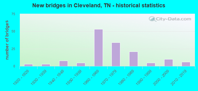
- New bridges - historical statistics
- 31920-1929
- 31930-1939
- 81940-1949
- 51950-1959
- 531960-1969
- 341970-1979
- 211980-1989
- 51990-1999
- 102000-2009
- 62010-2019
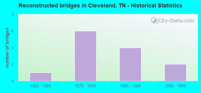
- Reconstructed bridges - Historical Statistics
- 11960-1969
- 61970-1979
- 41980-1989
- 21990-1999
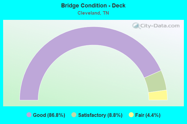
- Bridge Condition - Deck
- 86.8%Good
- 8.8%Satisfactory
- 4.4%Fair
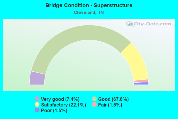
- Bridge Condition - Superstructure
- 7.4%Very good
- 67.6%Good
- 22.1%Satisfactory
- 1.5%Fair
- 1.5%Poor
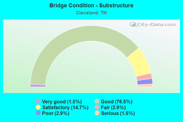
- Bridge Condition - Substructure
- 1.5%Very good
- 76.5%Good
- 14.7%Satisfactory
- 2.9%Fair
- 2.9%Poor
- 1.5%Serious
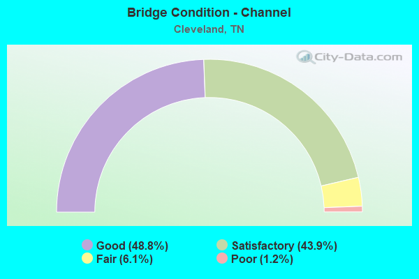
- Bridge Condition - Channel
- 48.8%Good
- 43.9%Satisfactory
- 6.1%Fair
- 1.2%Poor
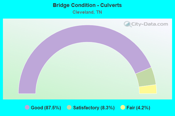
- Bridge Condition - Culverts
- 87.5%Good
- 8.3%Satisfactory
- 4.2%Fair
Find on map >> Show street view
Structure Number: 6SR0404001, Location: 1 MILE EAST OF I-75 (Lat: 35.145433, Lng: -84.928983), Route carried "under" structure: Bypass US 64, Year Built: 1965, Structure Length: 0. m, Average Daily Traffic: 21,054 (year 2020), Truck Traffic: 13%, Features Intersected: NFA A060, Facility Carried by Structure: NFA A060
Minimum Vertical Clearance: 7.67m (25.16ft), Kilometerpoint: 1.867, Lanes on structure: 2, Lanes under structure: 4, Material/Design: Concrete continuous, Design/Construction: Tee Beam, Length of Maximum Span: 15.2m (49.9ft)
Find on map >> Show street view
Structure Number: 6SR0404007, Location: IN THE CITY OF CLEVELAND (Lat: 35.133600, Lng: -84.895583), Route carried "under" structure: City street 3, Year Built: 1972, Structure Length: 0. m, Average Daily Traffic: 1,840 (year 2019), Truck Traffic: 5%, Features Intersected: SR 311
Minimum Vertical Clearance: 8.48m (27.82ft), Kilometerpoint: 13.995, Lanes on structure: 4, Lanes under structure: 2, Material/Design: Prestressed concrete continuous, Design/Construction: Stringer/Multi-beam, Length of Maximum Span: 22.9m (75.1ft)
Find on map >> Show street view
Structure Number: 6SR0404009, Location: IN THE CITY OF CLEVELAND (Lat: 35.132500, Lng: -84.889317), Route carried "under" structure: County highway 1181, Year Built: 1972, Structure Length: 0. m, Average Daily Traffic: 6,062 (year 2020), Truck Traffic: 3%, Features Intersected: SR 311, Facility Carried by Structure: FAP 311
Minimum Vertical Clearance: 4.72m (15.49ft), Kilometerpoint: 13.840, Lanes on structure: 4, Lanes under structure: 2, Material/Design: Steel continuous, Design/Construction: Stringer/Multi-beam, Length of Maximum Span: 32.6m (107.0ft)
Find on map >> Show street view
Structure Number: 6SR0404015, Location: IN CLEVELAND (Lat: 35.131217, Lng: -84.869467), Route carried "under" structure: State highway 311, Year Built: 1972, Structure Length: 0. m, Average Daily Traffic: 6,267 (year 2020), Truck Traffic: 4%, Features Intersected: SR 311(FAP)/SR 311(FAU)
Minimum Vertical Clearance: 5.66m (18.57ft), Kilometerpoint: 8.385, Lanes on structure: 4, Lanes under structure: 2, Material/Design: Steel continuous, Design/Construction: Stringer/Multi-beam, Length of Maximum Span: 36.6m (120.1ft)
Find on map >> Show street view
Structure Number: 6SR0404017, Location: IN CLEVELAND (Lat: 35.133033, Lng: -84.860217), Route carried "under" structure: State highway 74, Year Built: 1972, Structure Length: 0. m, Average Daily Traffic: 11,316 (year 2020), Truck Traffic: 4%, Features Intersected: SR 60 / SR 74, Facility Carried by Structure: FAP 60
Minimum Vertical Clearance: 5.72m (18.77ft), Kilometerpoint: 19.023, Lanes on structure: 4, Lanes under structure: 4, Material/Design: Steel continuous, Design/Construction: Stringer/Multi-beam, Length of Maximum Span: 36.9m (121.1ft)
Find on map >> Show street view
Structure Number: 6SR0404019, Location: IN THE CITY OF CLEVELAND (Lat: 35.146967, Lng: -84.850367), Route carried "under" structure: City street 712, Year Built: 1974, Structure Length: 0. m, Average Daily Traffic: 1,520 (year 2022), Truck Traffic: 5%, Features Intersected: SR 60, Facility Carried by Structure: FAP 60
Minimum Vertical Clearance: 4.67m (15.32ft), Kilometerpoint: 0.978, Lanes on structure: 4, Lanes under structure: 2, Material/Design: Prestressed concrete continuous, Design/Construction: Box Beam or Girders - Single/Spread, Length of Maximum Span: 23.5m (77.1ft)
Find on map >> Show street view
Structure Number: 6SR0404021, Location: IN CLEVELAND (Lat: 35.149750, Lng: -84.848167), Route carried "under" structure: US 64, Year Built: 1974, Structure Length: 0. m, Average Daily Traffic: 8,154 (year 2020), Truck Traffic: 4%, Features Intersected: SR 60 / SR 40, Facility Carried by Structure: FAP 60
Minimum Vertical Clearance: 5.11m (16.77ft), Kilometerpoint: 3.846, Lanes on structure: 6, Lanes under structure: 6, Material/Design: Prestressed concrete continuous, Design/Construction: Box Beam or Girders - Single/Spread, Length of Maximum Span: 30.5m (100.1ft)
Find on map >> Show street view
Structure Number: 6SR0600023, Location: IN THE CITY OF CLEVELAND (Lat: 35.154450, Lng: -84.844683), Route carried "under" structure: City street 706, Year Built: 1976, Structure Length: 0. m, Average Daily Traffic: 1,800 (year 2022), Truck Traffic: 2%, Features Intersected: SR 60 / NFA A706, Facility Carried by Structure: FAP 60
Minimum Vertical Clearance: 4.88m (16.01ft), Kilometerpoint: 1.006, Lanes on structure: 2, Lanes under structure: 2, Material/Design: Concrete, Design/Construction: Box Beam or Girders - Single/Spread, Length of Maximum Span: 27.7m (90.9ft)
Find on map >> Show street view
Structure Number: 6SR0600024, Location: IN THE CITY OF CLEVELAND (Lat: 35.154383, Lng: -84.844950), Route carried "under" structure: City street 706, Year Built: 1976, Structure Length: 0. m, Average Daily Traffic: 1,800 (year 2022), Truck Traffic: 2%, Features Intersected: SR 60 / NFA A706, Facility Carried by Structure: FAP 60
Minimum Vertical Clearance: 4.95m (16.24ft), Kilometerpoint: 1.038, Lanes on structure: 2, Lanes under structure: 2, Material/Design: Concrete, Design/Construction: Box Beam or Girders - Multiple, Length of Maximum Span: 27.7m (90.9ft)
Find on map >> Show street view
Structure Number: 6SR0600025, Location: IN THE CITY OF CLEVELAND (Lat: 35.165817, Lng: -84.847767), Route carried "under" structure: City street 576, Year Built: 1976, Structure Length: 0. m, Average Daily Traffic: 95 (year 2022), Truck Traffic: 2%, Features Intersected: SR60/ OVERHEAD BRIDGE RD, Facility Carried by Structure: FAP 60
Minimum Vertical Clearance: 5.59m (18.34ft), Kilometerpoint: 1.152, Lanes on structure: 3, Lanes under structure: 7, Material/Design: Steel continuous, Design/Construction: Stringer/Multi-beam, Length of Maximum Span: 42.7m (140.1ft)
Find on map >> Show street view
Structure Number: 6SR0600025, Location: NEAR CLEVELAND (Lat: 35.166517, Lng: -84.847900), Route carried "under" structure: County highway 1156, Year Built: 1976, Structure Length: 0. m, Average Daily Traffic: 10,170 (year 2020), Truck Traffic: 4%, Features Intersected: SR-60 / 20TH ST. N.E., Facility Carried by Structure: FAP 60
Minimum Vertical Clearance: 5.31m (17.42ft), Kilometerpoint: 0.016, Lanes on structure: 3, Lanes under structure: 2, Material/Design: Steel continuous, Design/Construction: Stringer/Multi-beam, Length of Maximum Span: 42.7m (140.1ft)
Find on map >> Show street view
Structure Number: 6SR0600026, Location: IN THE CITY OF CLEVELAND (Lat: 35.165833, Lng: -84.848083), Route carried "under" structure: City street 576, Year Built: 1976, Structure Length: 0. m, Average Daily Traffic: 95 (year 2022), Truck Traffic: 2%, Features Intersected: SR60/ OVERHEAD BRIDGE RD, Facility Carried by Structure: FAP 60
Minimum Vertical Clearance: 5.97m (19.59ft), Kilometerpoint: 1.125, Lanes on structure: 3, Lanes under structure: 7, Material/Design: Steel continuous, Design/Construction: Stringer/Multi-beam, Length of Maximum Span: 42.7m (140.1ft)
Find on map >> Show street view
Structure Number: 6SR0600026, Location: IN CLEVELAND (Lat: 35.166467, Lng: -84.848217), Route carried "under" structure: City street 3645, Year Built: 1976, Structure Length: 0. m, Average Daily Traffic: 4,409 (year 2020), Truck Traffic: 4%, Features Intersected: SR-60 / 20TH ST. N.E., Facility Carried by Structure: FAP 60
Minimum Vertical Clearance: 5.59m (18.34ft), Kilometerpoint: 3.283, Lanes on structure: 2, Lanes under structure: 6, Material/Design: Steel continuous, Design/Construction: Stringer/Multi-beam, Length of Maximum Span: 4.3m (14.1ft)
Find on map >> Show street view
Structure Number: 6SR3110001, Location: 1/2 MILE EAST OF I-75 (Lat: 35.148833, Lng: -84.937517), Route carried "under" structure: Bypass US 64, Year Built: 2017, Structure Length: 0. m, Average Daily Traffic: 21,054 (year 2020), Truck Traffic: 13%, Features Intersected: NFA A050, Facility Carried by Structure: NFA A050
Minimum Vertical Clearance: 5.08m (16.67ft), Kilometerpoint: 1.014, Lanes on structure: 4, Lanes under structure: 4, Material/Design: Prestressed concrete continuous, Design/Construction: Stringer/Multi-beam, Length of Maximum Span: 40.1m (131.6ft)