Bridge Statistics for Columbia, Missouri (MO)
Condition, Traffic, Stress, Structural Evaluation, Project Costs
- National Bridge Inventory (NBI) Statistics
- 255Number of bridges
- 2,582ft / 787mTotal length
- $8,034,000Total costs
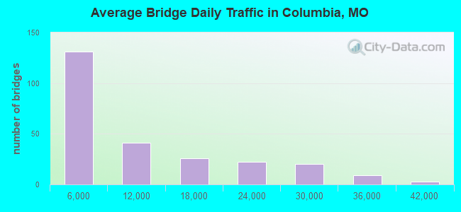
- 2,451,720Total average daily traffic
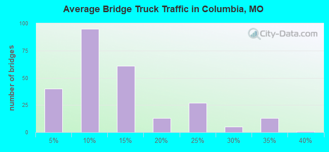
- 382,857Total average daily truck traffic
- National Bridge Inventory (NBI) Registered Bridges for Columbia
- No street view available for this location
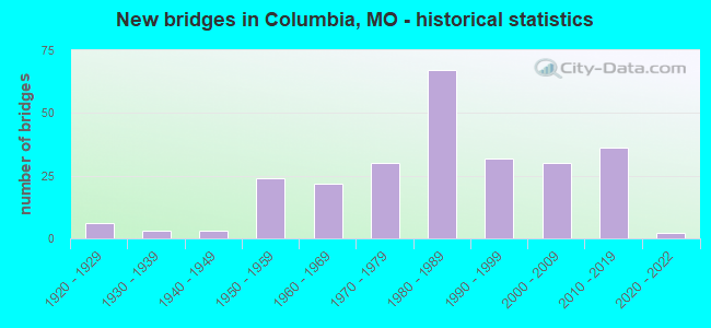
- New bridges - historical statistics
- 61920-1929
- 31930-1939
- 31940-1949
- 241950-1959
- 221960-1969
- 301970-1979
- 671980-1989
- 321990-1999
- 302000-2009
- 362010-2019
- 22020-2022
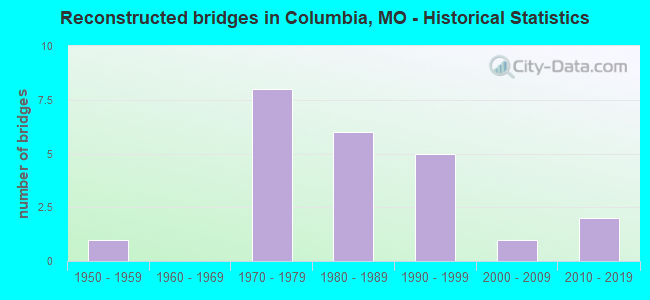
- Reconstructed bridges - Historical Statistics
- 11950-1959
- 01960-1969
- 81970-1979
- 61980-1989
- 51990-1999
- 12000-2009
- 22010-2019
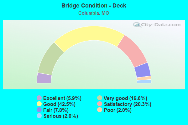
- Bridge Condition - Deck
- 5.9%Excellent
- 19.6%Very good
- 42.5%Good
- 20.3%Satisfactory
- 7.8%Fair
- 2.0%Poor
- 2.0%Serious
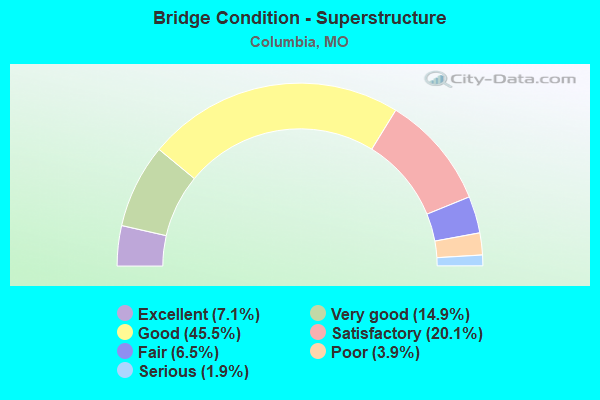
- Bridge Condition - Superstructure
- 7.1%Excellent
- 14.9%Very good
- 45.5%Good
- 20.1%Satisfactory
- 6.5%Fair
- 3.9%Poor
- 1.9%Serious
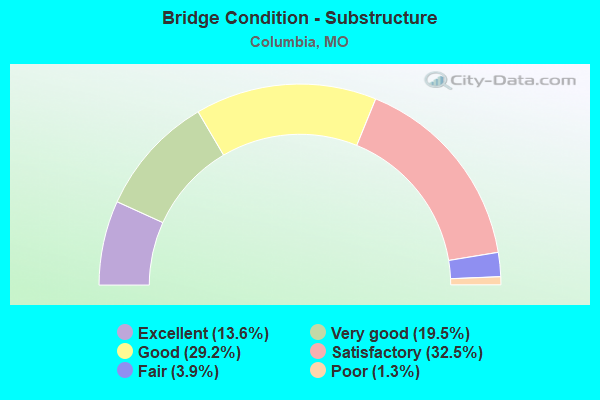
- Bridge Condition - Substructure
- 13.6%Excellent
- 19.5%Very good
- 29.2%Good
- 32.5%Satisfactory
- 3.9%Fair
- 1.3%Poor
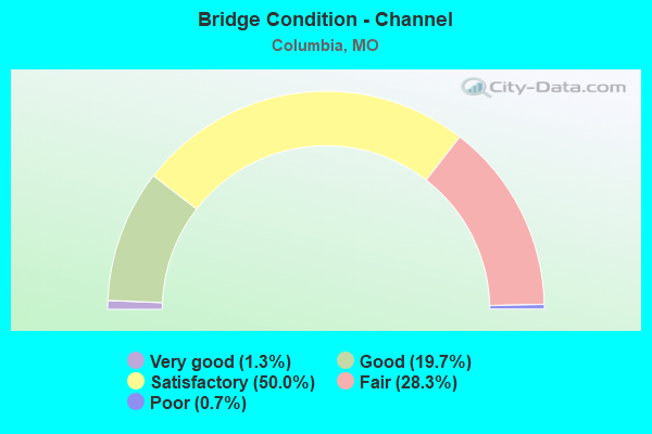
- Bridge Condition - Channel
- 1.3%Very good
- 19.7%Good
- 50.0%Satisfactory
- 28.3%Fair
- 0.7%Poor
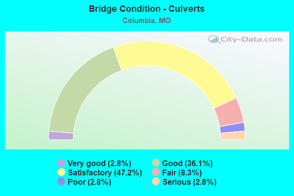
- Bridge Condition - Culverts
- 2.8%Very good
- 36.1%Good
- 47.2%Satisfactory
- 8.3%Fair
- 2.8%Poor
- 2.8%Serious
Find on map >> Show street view
Structure Number: 3362, Location: S 8 T 48 N R 12 W (Lat: 38.962736, Lng: -92.294839), Route carried "under" structure: Interstate 70, Year Built: 1992, Structure Length: 0. m, Average Daily Traffic: 16,789 (year 2021), Truck Traffic: 24%, Features Intersected: IS 70, Facility Carried by Structure: US 63 S
Minimum Vertical Clearance: 6.17m (20.24ft), Kilometerpoint: 207.184, Lanes on structure: 2, Lanes under structure: 4, Material/Design: Prestressed concrete continuous, Design/Construction: Stringer/Multi-beam, Length of Maximum Span: 35.1m (115.2ft)
Find on map >> Show street view
Structure Number: 3362, Location: S 8 T 48 N R 12 W (Lat: 38.962736, Lng: -92.294839), Route carried "under" structure: Interstate 70, Year Built: 1992, Structure Length: 0. m, Average Daily Traffic: 26,389 (year 2021), Truck Traffic: 32%, Features Intersected: IS 70, Facility Carried by Structure: US 63 S
Minimum Vertical Clearance: 5.38m (17.65ft), Kilometerpoint: 195.159, Lanes on structure: 2, Lanes under structure: 2, Material/Design: Prestressed concrete continuous, Design/Construction: Stringer/Multi-beam, Length of Maximum Span: 35.1m (115.2ft)
Find on map >> Show street view
Structure Number: 3363, Location: S 8 T 48 N R 12 W (Lat: 38.957742, Lng: -92.293203), Route carried "under" structure: US , Year Built: 1993, Structure Length: 0. m, Average Daily Traffic: 14,395 (year 2021), Truck Traffic: 8%, Features Intersected: US 63C, Facility Carried by Structure: US 63 N
Minimum Vertical Clearance: 6.12m (20.08ft), Kilometerpoint: 1.904, Lanes on structure: 2, Lanes under structure: 2, Material/Design: Prestressed concrete continuous, Design/Construction: Stringer/Multi-beam, Length of Maximum Span: 21.3m (69.9ft)
Find on map >> Show street view
Structure Number: 3363, Location: S 8 T 48 N R 12 W (Lat: 38.957742, Lng: -92.293203), Route carried "under" structure: City street , Year Built: 1993, Structure Length: 0. m, Average Daily Traffic: 8,829 (year 2021), Truck Traffic: 5%, Features Intersected: CST CONLEY RD, Facility Carried by Structure: US 63 N
Minimum Vertical Clearance: 6.12m (20.08ft), Kilometerpoint: 0.381, Lanes on structure: 2, Lanes under structure: 2, Material/Design: Prestressed concrete continuous, Design/Construction: Stringer/Multi-beam, Length of Maximum Span: 21.3m (69.9ft)
Find on map >> Show street view
Structure Number: 3364, Location: S 8 T 48 N R 12 W (Lat: 38.957406, Lng: -92.293389), Route carried "under" structure: US , Year Built: 1993, Structure Length: 0. m, Average Daily Traffic: 14,395 (year 2021), Truck Traffic: 8%, Features Intersected: US 63C, Facility Carried by Structure: US 63 S
Minimum Vertical Clearance: 5.23m (17.16ft), Kilometerpoint: 1.941, Lanes on structure: 2, Lanes under structure: 1, Material/Design: Prestressed concrete continuous, Design/Construction: Stringer/Multi-beam, Length of Maximum Span: 21.3m (69.9ft)
Find on map >> Show street view
Structure Number: 34363, Location: S 7 T 48 N R 11 W (Lat: 38.958667, Lng: -92.203972), Route carried "under" structure: Interstate 70, Year Built: 2013, Structure Length: 0. m, Average Daily Traffic: 18,385 (year 2021), Truck Traffic: 30%, Features Intersected: IS 70, Facility Carried by Structure: RT Z S
Minimum Vertical Clearance: 5.07m (16.63ft), Kilometerpoint: 215.084, Lanes on structure: 3, Lanes under structure: 2, Material/Design: Prestressed concrete continuous, Design/Construction: Box Beam or Girders - Single/Spread, Length of Maximum Span: 20.9m (68.6ft)
Find on map >> Show street view
Structure Number: 34363, Location: S 7 T 48 N R 11 W (Lat: 38.958667, Lng: -92.203972), Route carried "under" structure: Interstate 70, Year Built: 2013, Structure Length: 0. m, Average Daily Traffic: 19,089 (year 2021), Truck Traffic: 32%, Features Intersected: IS 70, Facility Carried by Structure: RT Z S
Minimum Vertical Clearance: 5.11m (16.77ft), Kilometerpoint: 187.257, Lanes on structure: 3, Lanes under structure: 2, Material/Design: Prestressed concrete continuous, Design/Construction: Box Beam or Girders - Single/Spread, Length of Maximum Span: 20.9m (68.6ft)
Find on map >> Show street view
Structure Number: 34762, Location: S 6 T 48 N R 12 W (Lat: 38.963836, Lng: -92.311564), Route carried "under" structure: Business State highway 70, Year Built: 2014, Structure Length: 0. m, Average Daily Traffic: 10,749 (year 2021), Truck Traffic: 5%, Features Intersected: LP 70, Facility Carried by Structure: RT B S
Minimum Vertical Clearance: 4.50m (14.76ft), Kilometerpoint: 3.729, Lanes on structure: 2, Lanes under structure: 2, Material/Design: Prestressed concrete, Design/Construction: Box Beam or Girders - Multiple, Length of Maximum Span: 18.3m (60.0ft)
Find on map >> Show street view
Structure Number: 35111, Location: S 1 T 48 N R 13 W (Lat: 38.968731, Lng: -92.324936), Route carried "under" structure: State highway 763, Year Built: 2015, Structure Length: 0. m, Average Daily Traffic: 9,400 (year 2021), Truck Traffic: 7%, Features Intersected: MO 763, Facility Carried by Structure: IS 70 W
Minimum Vertical Clearance: 4.85m (15.91ft), Kilometerpoint: 6.529, Lanes on structure: 2, Lanes under structure: 2, Material/Design: Steel, Design/Construction: Stringer/Multi-beam, Length of Maximum Span: 26.5m (86.9ft)
Find on map >> Show street view
Structure Number: 35111, Location: S 1 T 48 N R 13 W (Lat: 38.968731, Lng: -92.324936), Route carried "under" structure: State highway 763, Year Built: 2015, Structure Length: 0. m, Average Daily Traffic: 9,375 (year 2021), Truck Traffic: 5%, Features Intersected: MO 763, Facility Carried by Structure: IS 70 W
Minimum Vertical Clearance: 4.78m (15.68ft), Kilometerpoint: 4.112, Lanes on structure: 2, Lanes under structure: 2, Material/Design: Steel, Design/Construction: Stringer/Multi-beam, Length of Maximum Span: 26.5m (86.9ft)
Find on map >> Show street view
Structure Number: 35115, Location: S 1 T 48 N R 13 W (Lat: 38.969336, Lng: -92.338450), Route carried "under" structure: City street , Year Built: 2016, Structure Length: 0. m, Average Daily Traffic: 5,289 (year 2021), Truck Traffic: 4%, Features Intersected: CST GARTH AVE, Facility Carried by Structure: IS 70 W
Minimum Vertical Clearance: 4.93m (16.17ft), Kilometerpoint: 1.579, Lanes on structure: 3, Lanes under structure: 2, Material/Design: Steel, Design/Construction: Stringer/Multi-beam, Length of Maximum Span: 22.8m (74.8ft)
Find on map >> Show street view
Structure Number: 35122, Location: S 2 T 48 N R 13 W (Lat: 38.966592, Lng: -92.351372), Route carried "under" structure: Business State highway 70, Year Built: 2015, Structure Length: 0. m, Average Daily Traffic: 11,848 (year 2021), Truck Traffic: 5%, Features Intersected: LP 70
Minimum Vertical Clearance: 4.78m (15.68ft), Kilometerpoint: 0.259, Lanes on structure: 4, Lanes under structure: 4, Material/Design: Steel, Design/Construction: Stringer/Multi-beam, Length of Maximum Span: 25.7m (84.3ft)
Find on map >> Show street view
Structure Number: 35148, Location: S 1 T 48 N R 13 W (Lat: 38.969228, Lng: -92.338419), Route carried "under" structure: City street , Year Built: 2016, Structure Length: 0. m, Average Daily Traffic: 5,289 (year 2021), Truck Traffic: 4%, Features Intersected: CST GARTH AVE, Facility Carried by Structure: IS 70 E
Minimum Vertical Clearance: 4.65m (15.26ft), Kilometerpoint: 1.590, Lanes on structure: 3, Lanes under structure: 2, Material/Design: Steel, Design/Construction: Stringer/Multi-beam, Length of Maximum Span: 21.9m (71.9ft)
Find on map >> Show street view
Structure Number: 35154, Location: S 1 T 48 N R 13 W (Lat: 38.968614, Lng: -92.324889), Route carried "under" structure: State highway 763, Year Built: 2016, Structure Length: 0. m, Average Daily Traffic: 9,400 (year 2021), Truck Traffic: 7%, Features Intersected: MO 763, Facility Carried by Structure: IS 70 E
Minimum Vertical Clearance: 4.83m (15.85ft), Kilometerpoint: 6.542, Lanes on structure: 2, Lanes under structure: 2, Material/Design: Steel continuous, Design/Construction: Stringer/Multi-beam, Length of Maximum Span: 13.9m (45.6ft)
Find on map >> Show street view
Structure Number: 36, Location: S 10 T 48 N R 13 W (Lat: 38.968267, Lng: -92.371136), Route carried "under" structure: Interstate 70, Year Built: 1958, Structure Length: 0. m, Average Daily Traffic: 22,268 (year 2021), Truck Traffic: 24%, Features Intersected: IS 70, Facility Carried by Structure: MO 740 E
Minimum Vertical Clearance: 5.08m (16.67ft), Kilometerpoint: 200.211, Lanes on structure: 4, Lanes under structure: 2, Material/Design: Steel continuous, Design/Construction: Stringer/Multi-beam, Length of Maximum Span: 15.5m (50.9ft)
Find on map >> Show street view
Structure Number: 36, Location: S 10 T 48 N R 13 W (Lat: 38.968267, Lng: -92.371136), Route carried "under" structure: Interstate 70, Year Built: 1958, Structure Length: 0. m, Average Daily Traffic: 31,066 (year 2021), Truck Traffic: 24%, Features Intersected: IS 70, Facility Carried by Structure: MO 740 E
Minimum Vertical Clearance: 4.85m (15.91ft), Kilometerpoint: 202.115, Lanes on structure: 4, Lanes under structure: 2, Material/Design: Steel continuous, Design/Construction: Stringer/Multi-beam, Length of Maximum Span: 15.5m (50.9ft)
Find on map >> Show street view
Structure Number: 574, Location: S 8 T 48 N R 12 W (Lat: 38.961758, Lng: -92.292044), Route carried "under" structure: Interstate 70, Year Built: 1961, Structure Length: 0. m, Average Daily Traffic: 26,389 (year 2021), Truck Traffic: 32%, Features Intersected: IS 70, Facility Carried by Structure: US 63C S
Minimum Vertical Clearance: 5.18m (16.99ft), Kilometerpoint: 194.906, Lanes on structure: 6, Lanes under structure: 2, Material/Design: Steel continuous, Design/Construction: Stringer/Multi-beam, Length of Maximum Span: 17.7m (58.1ft)
Find on map >> Show street view
Structure Number: 574, Location: S 8 T 48 N R 12 W (Lat: 38.961758, Lng: -92.292044), Route carried "under" structure: Interstate 70, Year Built: 1961, Structure Length: 0. m, Average Daily Traffic: 25,676 (year 2021), Truck Traffic: 30%, Features Intersected: IS 70, Facility Carried by Structure: US 63C S
Minimum Vertical Clearance: 5.00m (16.40ft), Kilometerpoint: 207.429, Lanes on structure: 6, Lanes under structure: 2, Material/Design: Steel continuous, Design/Construction: Stringer/Multi-beam, Length of Maximum Span: 17.7m (58.1ft)
Find on map >> Show street view
Structure Number: 618, Location: S 6 T 48 N R 12 W (Lat: 38.967147, Lng: -92.308303), Route carried "under" structure: Interstate 70, Year Built: 1957, Structure Length: 0. m, Average Daily Traffic: 25,242 (year 2021), Truck Traffic: 24%, Features Intersected: IS 70, Facility Carried by Structure: RT B S
Minimum Vertical Clearance: 5.21m (17.09ft), Kilometerpoint: 196.442, Lanes on structure: 5, Lanes under structure: 2, Material/Design: Concrete continuous, Design/Construction: Slab, Length of Maximum Span: 13.4m (44.0ft)
Find on map >> Show street view
Structure Number: 618, Location: S 6 T 48 N R 12 W (Lat: 38.967147, Lng: -92.308303), Route carried "under" structure: Interstate 70, Year Built: 1957, Structure Length: 0. m, Average Daily Traffic: 27,946 (year 2021), Truck Traffic: 24%, Features Intersected: IS 70, Facility Carried by Structure: RT B S
Minimum Vertical Clearance: 5.31m (17.42ft), Kilometerpoint: 205.874, Lanes on structure: 5, Lanes under structure: 2, Material/Design: Concrete continuous, Design/Construction: Slab, Length of Maximum Span: 13.4m (44.0ft)
Find on map >> Show street view
Structure Number: 65, Location: S 1 T 48 N R 13 W (Lat: 38.969069, Lng: -92.333669), Route carried "under" structure: Interstate 70, Year Built: 1957, Structure Length: 0. m, Average Daily Traffic: 33,755 (year 2021), Truck Traffic: 24%, Features Intersected: IS 70, Facility Carried by Structure: MO 163 S
Minimum Vertical Clearance: 4.93m (16.17ft), Kilometerpoint: 203.660, Lanes on structure: 6, Lanes under structure: 2, Material/Design: Concrete continuous, Design/Construction: Slab, Length of Maximum Span: 13.4m (44.0ft)
Find on map >> Show street view
Structure Number: 65, Location: S 1 T 48 N R 13 W (Lat: 38.969069, Lng: -92.333669), Route carried "under" structure: Interstate 70, Year Built: 1957, Structure Length: 0. m, Average Daily Traffic: 32,591 (year 2021), Truck Traffic: 24%, Features Intersected: IS 70, Facility Carried by Structure: MO 163 S
Minimum Vertical Clearance: 4.90m (16.08ft), Kilometerpoint: 198.664, Lanes on structure: 6, Lanes under structure: 2, Material/Design: Concrete continuous, Design/Construction: Slab, Length of Maximum Span: 13.4m (44.0ft)
Find on map >> Show street view
Structure Number: 6586, Location: S 10 T 48 N R 12 W (Lat: 38.960119, Lng: -92.253136), Route carried "under" structure: Interstate 70, Year Built: 1957, Structure Length: 0. m, Average Daily Traffic: 21,892 (year 2021), Truck Traffic: 32%, Features Intersected: IS 70, Facility Carried by Structure: ST CHARLES RD E
Minimum Vertical Clearance: 4.85m (15.91ft), Kilometerpoint: 191.528, Lanes on structure: 3, Lanes under structure: 2, Material/Design: Steel continuous, Design/Construction: Stringer/Multi-beam, Length of Maximum Span: 17.7m (58.1ft)
Find on map >> Show street view
Structure Number: 6586, Location: S 10 T 48 N R 12 W (Lat: 38.960119, Lng: -92.253136), Route carried "under" structure: Interstate 70, Year Built: 1957, Structure Length: 0. m, Average Daily Traffic: 25,676 (year 2021), Truck Traffic: 30%, Features Intersected: IS 70, Facility Carried by Structure: ST CHARLES RD E
Minimum Vertical Clearance: 5.11m (16.77ft), Kilometerpoint: 210.804, Lanes on structure: 3, Lanes under structure: 2, Material/Design: Steel continuous, Design/Construction: Stringer/Multi-beam, Length of Maximum Span: 17.7m (58.1ft)
Find on map >> Show street view
Structure Number: 6599, Location: S 5 T 48 N R 12 W (Lat: 38.964758, Lng: -92.302342), Route carried "under" structure: Interstate 70, Year Built: 1957, Structure Length: 0. m, Average Daily Traffic: 27,946 (year 2021), Truck Traffic: 24%, Features Intersected: IS 70
Minimum Vertical Clearance: 4.70m (15.42ft), Kilometerpoint: 206.463, Lanes on structure: 2, Lanes under structure: 2, Material/Design: Steel continuous, Design/Construction: Stringer/Multi-beam, Length of Maximum Span: 21.3m (69.9ft)