Bridge Statistics for Corsicana, Texas (TX)
Condition, Traffic, Stress, Structural Evaluation, Project Costs
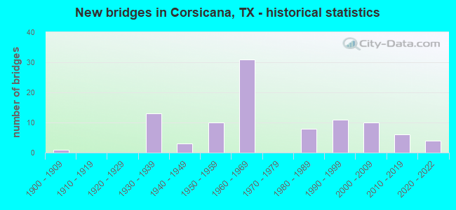
- New bridges - historical statistics
- 11900-1909
- 131930-1939
- 31940-1949
- 101950-1959
- 311960-1969
- 81980-1989
- 111990-1999
- 102000-2009
- 62010-2019
- 42020-2022
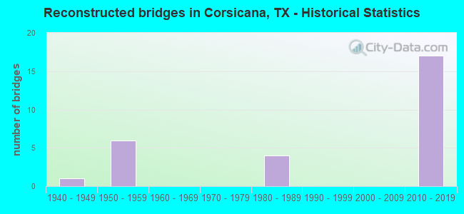
- Reconstructed bridges - Historical Statistics
- 11940-1949
- 61950-1959
- 01960-1969
- 01970-1979
- 41980-1989
- 01990-1999
- 02000-2009
- 172010-2019
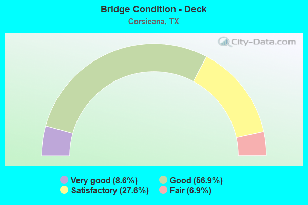
- Bridge Condition - Deck
- 8.6%Very good
- 56.9%Good
- 27.6%Satisfactory
- 6.9%Fair
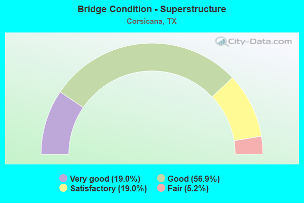
- Bridge Condition - Superstructure
- 19.0%Very good
- 56.9%Good
- 19.0%Satisfactory
- 5.2%Fair
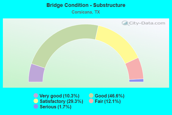
- Bridge Condition - Substructure
- 10.3%Very good
- 46.6%Good
- 29.3%Satisfactory
- 12.1%Fair
- 1.7%Serious
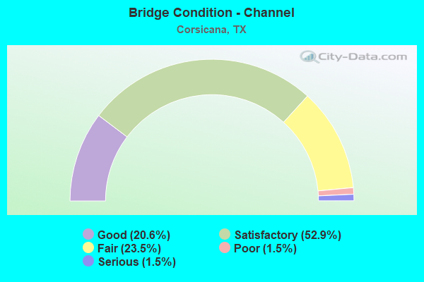
- Bridge Condition - Channel
- 20.6%Good
- 52.9%Satisfactory
- 23.5%Fair
- 1.5%Poor
- 1.5%Serious
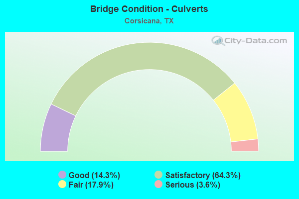
- Bridge Condition - Culverts
- 14.3%Good
- 64.3%Satisfactory
- 17.9%Fair
- 3.6%Serious
Find on map >> Show street view
Structure Number: 181750009206169, Location: 3.60 MI N OF SH 31 (Lat: 32.146081, Lng: -96.463700), Route carried "on" structure: Interstate 45, Year Built: 1964, Year Reconstructed: 2019, Status: Open, Structure Length: 5.49m (18.01ft), Average Daily Traffic: 21,465 (year 2019), Truck Traffic: 23%, Average Future Daily Traffic: 24,890 (year 2033), Design Load: HS 20, Features Intersected: BRIAR CRK
Minimum Vertical Clearance: 30+ m (98+ ft), Kilometerpoint: 39.876, Lanes on structure: 3, Owner: State Highway Agency, Approaching Roadway Width: 16.5m (54.1ft), Material/Design: Prestressed concrete, Design/Construction: Stringer/Multi-beam, Number Of Spans In Main Unit: 4, Length of Maximum Span: 13.7m (44.9ft), Curb-To-Curb Width: 16.6m (54.5ft), Out-to-Out Width: 17.7m (58.1ft)
Condition: Deck: Satisfactory, Superstructure: Good, Substructure: Satisfactory, Channel: Satisfactory, Operating Rating: 54.4 metric tons, Method Used To Determine Operating Rating: Load Factor (LF), Inventory Rating: 32.7 metric tons, Method Used To Determine Inventory Rating: Load Factor (LF), Structural Evaluation: Equal to present minimum criteria, Deck Geometry: Equal to present minimum criteria, Waterway Adequacy: Superior to present desirable criteria, Approach Roadway Alignment: Equal to present desirable criteria, Designated Inspection Frequency: Every 24 months, Inspection Date: Febuary 2020, Deck Structure Type: Concrete Cast-file-Place
Find on map >> Show street view
Structure Number: 18175000920617, Location: 3.60 MI N OF SH 31 (Lat: 32.145919, Lng: -96.464042), Route carried "on" structure: Interstate 45, Year Built: 1964, Year Reconstructed: 2019, Status: Open, Structure Length: 5.49m (18.01ft), Average Daily Traffic: 20,181 (year 2019), Truck Traffic: 23%, Average Future Daily Traffic: 24,890 (year 2033), Design Load: HS 20, Features Intersected: BRIAR CRK
Minimum Vertical Clearance: 30+ m (98+ ft), Kilometerpoint: 39.876, Lanes on structure: 3, Owner: State Highway Agency, Approaching Roadway Width: 16.5m (54.1ft), Material/Design: Prestressed concrete, Design/Construction: Stringer/Multi-beam, Number Of Spans In Main Unit: 4, Length of Maximum Span: 13.7m (44.9ft), Curb-To-Curb Width: 16.6m (54.5ft), Out-to-Out Width: 17.0m (55.8ft)
Condition: Deck: Satisfactory, Superstructure: Good, Substructure: Satisfactory, Channel: Satisfactory, Operating Rating: 54.4 metric tons, Method Used To Determine Operating Rating: Load Factor (LF), Inventory Rating: 32.7 metric tons, Method Used To Determine Inventory Rating: Load Factor (LF), Structural Evaluation: Equal to present minimum criteria, Deck Geometry: Equal to present minimum criteria, Waterway Adequacy: Superior to present desirable criteria, Approach Roadway Alignment: Equal to present desirable criteria, Designated Inspection Frequency: Every 24 months, Inspection Date: Febuary 2020, Deck Structure Type: Concrete Cast-file-Place
Find on map >> Show street view
Structure Number: 181750009206171, Location: 3.60 MI N OF SH 31 (Lat: 32.145781, Lng: -96.464339), Route carried "on" structure: ServiceInterstate 45, Year Built: 1964, Status: Open, Structure Length: 4.57m (14.99ft), Average Daily Traffic: 100 (year 2020), Truck Traffic: 22%, Average Future Daily Traffic: 80 (year 2033), Design Load: H 15, Features Intersected: BRIAR CRK
Minimum Vertical Clearance: 30+ m (98+ ft), Kilometerpoint: 39.876, Lanes on structure: 2, Owner: State Highway Agency, Approaching Roadway Width: 5.5m (18.0ft), Material/Design: Prestressed concrete, Design/Construction: Stringer/Multi-beam, Number Of Spans In Main Unit: 3, Length of Maximum Span: 15.2m (49.9ft), Curb-To-Curb Width: 7.3m (24.0ft), Out-to-Out Width: 7.8m (25.6ft)
Condition: Deck: Good, Superstructure: Good, Substructure: Good, Channel: Fair, Operating Rating: 54.4 metric tons, Method Used To Determine Operating Rating: Load Factor (LF), Inventory Rating: 31.7 metric tons, Method Used To Determine Inventory Rating: Load Factor (LF), Structural Evaluation: Better than present minimum criteria, Deck Geometry: Equal to present minimum criteria, Waterway Adequacy: Better than present minimum criteria, Approach Roadway Alignment: Equal to present desirable criteria, Designated Inspection Frequency: Every 24 months, Inspection Date: Febuary 2020, Deck Structure Type: Concrete Cast-file-Place
Find on map >> Show street view
Structure Number: 181750009206172, Location: 2.65 MI N OF SH 31 (Lat: 32.134281, Lng: -96.456297), Route carried "on" structure: County highway 242, Year Built: 1964, Status: Open, Structure Length: 6.74m (22.11ft), Average Daily Traffic: 57 (year 2008), Average Future Daily Traffic: 40 (year 2028), Design Load: H 15, Features Intersected: IH 45, Facility Carried by Structure: NE CR 100
Minimum Vertical Clearance: 30+ m (98+ ft), Kilometerpoint: 38.425, Lanes on structure: 2, Lanes under structure: 6, Owner: State Highway Agency, Approaching Roadway Width: 6.7m (22.0ft), Material/Design: Prestressed concrete, Design/Construction: Stringer/Multi-beam, Number Of Spans In Main Unit: 4, Length of Maximum Span: 18.3m (60.0ft), Curb-To-Curb Width: 7.3m (24.0ft), Out-to-Out Width: 7.8m (25.6ft)
Condition: Deck: Good, Superstructure: Good, Substructure: Good, Operating Rating: 54.4 metric tons, Method Used To Determine Operating Rating: Load Factor (LF), Inventory Rating: 31.7 metric tons, Method Used To Determine Inventory Rating: Load Factor (LF), Structural Evaluation: Better than present minimum criteria, Deck Geometry: Equal to present minimum criteria, Underclear: Equal to present minimum criteria, Approach Roadway Alignment: Equal to present desirable criteria, Designated Inspection Frequency: Every 24 months, Inspection Date: Febuary 2020, Deck Structure Type: Concrete Cast-file-Place
Find on map >> Show street view
Structure Number: 181750009206173, Location: 2.55 MI N OF SH 31 (Lat: 32.132689, Lng: -96.455247), Route carried "on" structure: Interstate 45, Year Built: 1964, Status: Open, Structure Length: 0.70m (2.30ft), Average Daily Traffic: 40,397 (year 2020), Truck Traffic: 23%, Average Future Daily Traffic: 49,780 (year 2033), Design Load: HS 20, Features Intersected: BRIAR CREEK BRANCH
Minimum Vertical Clearance: 30+ m (98+ ft), Kilometerpoint: 38.233, Lanes on structure: 6, Owner: State Highway Agency, Approaching Roadway Width: 34.1m (111.9ft), Skew: 30 degrees, Material/Design: Concrete, Design/Construction: Culvert, Number Of Spans In Main Unit: 3, Length of Maximum Span: 2.1m (6.9ft)
Condition: Channel: Satisfactory, Culverts: Satisfactory, Operating Rating: 39.9 metric tons, Method Used To Determine Operating Rating: Load Factor (LF), Inventory Rating: 23.6 metric tons, Method Used To Determine Inventory Rating: Load Factor (LF), Structural Evaluation: Somewhat better than minimum adequacy, Waterway Adequacy: Equal to present minimum criteria, Approach Roadway Alignment: Equal to present desirable criteria, Designated Inspection Frequency: Every 24 months, Inspection Date: Febuary 2020
Find on map >> Show street view
Structure Number: 181750009206174, Location: 1.70 MI N OF SH 31 (Lat: 32.122736, Lng: -96.448725), Route carried "on" structure: Interstate 45, Year Built: 1964, Status: Open, Structure Length: 1.83m (6.00ft), Average Daily Traffic: 40,397 (year 2020), Truck Traffic: 23%, Average Future Daily Traffic: 49,780 (year 2033), Design Load: HS 20, Features Intersected: BRIAR CREEK BRANCH
Minimum Vertical Clearance: 30+ m (98+ ft), Kilometerpoint: 36.949, Lanes on structure: 6, Owner: State Highway Agency, Approaching Roadway Width: 34.1m (111.9ft), Skew: 31 degrees, Material/Design: Concrete, Design/Construction: Culvert, Number Of Spans In Main Unit: 6, Length of Maximum Span: 2.7m (8.9ft)
Condition: Channel: Fair, Culverts: Satisfactory, Operating Rating: 39.9 metric tons, Method Used To Determine Operating Rating: Load Factor (LF), Inventory Rating: 23.6 metric tons, Method Used To Determine Inventory Rating: Load Factor (LF), Structural Evaluation: Somewhat better than minimum adequacy, Waterway Adequacy: Superior to present desirable criteria, Approach Roadway Alignment: Equal to present desirable criteria, Designated Inspection Frequency: Every 24 months, Inspection Date: Febuary 2020
Find on map >> Show street view
Structure Number: 181750009206175, Location: 1.70 MI N OF SH 31 (Lat: 32.122819, Lng: -96.448231), Route carried "on" structure: ServiceInterstate 45, Year Built: 1964, Status: Open, Structure Length: 1.83m (6.00ft), Average Daily Traffic: 50 (year 2010), Truck Traffic: 3%, Average Future Daily Traffic: 80 (year 2030), Design Load: HS 20, Features Intersected: BRIAR CREEK BRANCH
Minimum Vertical Clearance: 30+ m (98+ ft), Kilometerpoint: 36.949, Lanes on structure: 2, Owner: State Highway Agency, Approaching Roadway Width: 4.9m (16.1ft), Skew: 1 degrees, Material/Design: Concrete, Design/Construction: Culvert, Number Of Spans In Main Unit: 6, Length of Maximum Span: 2.7m (8.9ft)
Condition: Channel: Fair, Culverts: Satisfactory, Operating Rating: 39.9 metric tons, Method Used To Determine Operating Rating: Load Factor (LF), Inventory Rating: 23.6 metric tons, Method Used To Determine Inventory Rating: Load Factor (LF), Structural Evaluation: Equal to present minimum criteria, Waterway Adequacy: Better than present minimum criteria, Approach Roadway Alignment: Equal to present desirable criteria, Designated Inspection Frequency: Every 24 months, Inspection Date: Febuary 2020
Find on map >> Show street view
Structure Number: 181750009206176, Location: 1.25 MI N OF SH 31 (Lat: 32.116153, Lng: -96.445122), Route carried "on" structure: County highway 273, Year Built: 1964, Status: Open, Structure Length: 7.04m (23.10ft), Average Daily Traffic: 1,248 (year 2020), Average Future Daily Traffic: 650 (year 2028), Design Load: H 15, Features Intersected: IH 45, Facility Carried by Structure: WEST ROANE RD
Minimum Vertical Clearance: 30+ m (98+ ft), Kilometerpoint: 36.152, Lanes on structure: 2, Lanes under structure: 6, Owner: State Highway Agency, Approaching Roadway Width: 6.1m (20.0ft), Skew: 3 degrees, Material/Design: Prestressed concrete, Design/Construction: Stringer/Multi-beam, Number Of Spans In Main Unit: 4, Length of Maximum Span: 19.8m (65.0ft), Curb-To-Curb Width: 7.3m (24.0ft), Out-to-Out Width: 7.8m (25.6ft)
Condition: Deck: Satisfactory, Superstructure: Good, Substructure: Satisfactory, Operating Rating: 54.4 metric tons, Method Used To Determine Operating Rating: Load Factor (LF), Inventory Rating: 29.0 metric tons, Method Used To Determine Inventory Rating: Load Factor (LF), Structural Evaluation: Equal to present minimum criteria, Deck Geometry: Meets minimum limits, Underclear: Meets minimum limits, Approach Roadway Alignment: Equal to present desirable criteria, Designated Inspection Frequency: Every 24 months, Inspection Date: Febuary 2020, Deck Structure Type: Concrete Cast-file-Place
Find on map >> Show street view
Structure Number: 181750009206177, Location: 0.60 MI N OF SH 31 (Lat: 32.106314, Lng: -96.442875), Route carried "on" structure: County highway 317, Year Built: 1964, Status: Open, Structure Length: 7.01m (23.00ft), Average Daily Traffic: 284 (year 2019), Average Future Daily Traffic: 71,712 (year 2036), Design Load: H 15, Features Intersected: IH45, Facility Carried by Structure: COUNTY RD
Minimum Vertical Clearance: 30+ m (98+ ft), Kilometerpoint: 35.042, Lanes on structure: 2, Lanes under structure: 4, Owner: State Highway Agency, Approaching Roadway Width: 6.7m (22.0ft), Skew: 1 degrees, Material/Design: Prestressed concrete, Design/Construction: Stringer/Multi-beam, Number Of Spans In Main Unit: 4, Length of Maximum Span: 19.8m (65.0ft), Curb-To-Curb Width: 7.3m (24.0ft), Out-to-Out Width: 7.8m (25.6ft)
Condition: Deck: Good, Superstructure: Good, Substructure: Good, Operating Rating: 63.5 metric tons, Method Used To Determine Operating Rating: Load Factor (LF), Inventory Rating: 29.9 metric tons, Method Used To Determine Inventory Rating: Load Factor (LF), Structural Evaluation: Better than present minimum criteria, Deck Geometry: Somewhat better than minimum adequacy, Underclear: Somewhat better than minimum adequacy, Approach Roadway Alignment: Equal to present desirable criteria, Designated Inspection Frequency: Every 24 months, Inspection Date: November 2021, Deck Structure Type: Concrete Cast-file-Place
Find on map >> Show street view
Structure Number: 181750009206178, Location: 0.25 MI N OF SH 31 (Lat: 32.101550, Lng: -96.441725), Route carried "on" structure: Interstate 45, Year Built: 1964, Year Reconstructed: 2018, Status: Open, Structure Length: 3.66m (12.01ft), Average Daily Traffic: 21,677 (year 2019), Truck Traffic: 23%, Average Future Daily Traffic: 23,540 (year 2033), Design Load: HS 20, Features Intersected: POST OAK CREEK
Minimum Vertical Clearance: 30+ m (98+ ft), Kilometerpoint: 34.498, Lanes on structure: 4, Owner: State Highway Agency, Approaching Roadway Width: 18.9m (62.0ft), Skew: 1 degrees, Material/Design: Prestressed concrete, Design/Construction: Stringer/Multi-beam, Number Of Spans In Main Unit: 3, Length of Maximum Span: 12.2m (40.0ft), Curb-To-Curb Width: 19.1m (62.7ft), Out-to-Out Width: 20.1m (65.9ft)
Condition: Deck: Satisfactory, Superstructure: Good, Substructure: Good, Channel: Satisfactory, Operating Rating: 68.0 metric tons, Method Used To Determine Operating Rating: Load Factor (LF), Inventory Rating: 40.8 metric tons, Method Used To Determine Inventory Rating: Load Factor (LF), Structural Evaluation: Better than present minimum criteria, Deck Geometry: Somewhat better than minimum adequacy, Waterway Adequacy: Superior to present desirable criteria, Approach Roadway Alignment: Equal to present desirable criteria, Designated Inspection Frequency: Every 24 months, Inspection Date: November 2021, Deck Structure Type: Concrete Cast-file-Place
Find on map >> Show street view
Structure Number: 181750009206179, Location: 0.25 MI N OF SH 31 (Lat: 32.101719, Lng: -96.441989), Route carried "on" structure: Interstate 45, Year Built: 1964, Year Reconstructed: 2018, Status: Open, Structure Length: 3.66m (12.01ft), Average Daily Traffic: 18,112 (year 2019), Truck Traffic: 23%, Average Future Daily Traffic: 23,540 (year 2033), Design Load: HS 20, Features Intersected: POST OAK CREEK
Minimum Vertical Clearance: 30+ m (98+ ft), Kilometerpoint: 34.503, Lanes on structure: 3, Owner: State Highway Agency, Approaching Roadway Width: 16.5m (54.1ft), Skew: 1 degrees, Material/Design: Prestressed concrete, Design/Construction: Stringer/Multi-beam, Number Of Spans In Main Unit: 3, Length of Maximum Span: 12.2m (40.0ft), Curb-To-Curb Width: 16.6m (54.5ft), Out-to-Out Width: 17.0m (55.8ft)
Condition: Deck: Satisfactory, Superstructure: Good, Substructure: Good, Channel: Good, Operating Rating: 68.0 metric tons, Method Used To Determine Operating Rating: Load Factor (LF), Inventory Rating: 40.8 metric tons, Method Used To Determine Inventory Rating: Load Factor (LF), Structural Evaluation: Better than present minimum criteria, Deck Geometry: Equal to present minimum criteria, Waterway Adequacy: Superior to present desirable criteria, Approach Roadway Alignment: Equal to present desirable criteria, Designated Inspection Frequency: Every 24 months, Inspection Date: November 2021, Deck Structure Type: Concrete Cast-file-Place
Find on map >> Show street view
Structure Number: 18175000920618, Location: IH 45 AT SH 31 (Lat: 32.098158, Lng: -96.440981), Route carried "on" structure: Interstate 45, Year Built: 1964, Year Reconstructed: 2018, Status: Open, Structure Length: 4.88m (16.01ft), Average Daily Traffic: 21,826 (year 2019), Truck Traffic: 23%, Average Future Daily Traffic: 24,360 (year 2033), Design Load: HS 20, Features Intersected: SH 31
Minimum Vertical Clearance: 30+ m (98+ ft), Kilometerpoint: 34.115, Lanes on structure: 2, Lanes under structure: 4, Owner: State Highway Agency, Approaching Roadway Width: 17.7m (58.1ft), Skew: 1 degrees, Material/Design: Prestressed concrete, Design/Construction: Stringer/Multi-beam, Number Of Spans In Main Unit: 4, Length of Maximum Span: 13.7m (44.9ft), Curb-To-Curb Width: 17.8m (58.4ft), Out-to-Out Width: 18.9m (62.0ft)
Condition: Deck: Satisfactory, Superstructure: Satisfactory, Substructure: Good, Operating Rating: 68.0 metric tons, Method Used To Determine Operating Rating: Load Factor (LF), Inventory Rating: 40.8 metric tons, Method Used To Determine Inventory Rating: Load Factor (LF), Structural Evaluation: Equal to present minimum criteria, Deck Geometry: Superior to present desirable criteria, Underclear: Meets minimum limits, Approach Roadway Alignment: Equal to present desirable criteria, Designated Inspection Frequency: Every 24 months, Inspection Date: November 2021, Deck Structure Type: Concrete Cast-file-Place, Wearing Surface/Protective System: Wearing Surface: Bituminous
Find on map >> Show street view
Structure Number: 181750009206181, Location: IH 45 AT SH 31 (Lat: 32.098189, Lng: -96.441200), Route carried "on" structure: Interstate 45, Year Built: 1964, Year Reconstructed: 2018, Status: Open, Structure Length: 4.88m (16.01ft), Average Daily Traffic: 20,936 (year 2019), Truck Traffic: 23%, Average Future Daily Traffic: 24,360 (year 2033), Design Load: HS 20, Features Intersected: SH 31
Minimum Vertical Clearance: 30+ m (98+ ft), Kilometerpoint: 34.108, Lanes on structure: 2, Lanes under structure: 4, Owner: State Highway Agency, Approaching Roadway Width: 16.5m (54.1ft), Skew: 1 degrees, Material/Design: Prestressed concrete, Design/Construction: Stringer/Multi-beam, Number Of Spans In Main Unit: 4, Length of Maximum Span: 13.7m (44.9ft), Curb-To-Curb Width: 16.4m (53.8ft), Out-to-Out Width: 16.7m (54.8ft)
Condition: Deck: Fair, Superstructure: Good, Substructure: Good, Operating Rating: 68.0 metric tons, Method Used To Determine Operating Rating: Load Factor (LF), Inventory Rating: 40.8 metric tons, Method Used To Determine Inventory Rating: Load Factor (LF), Structural Evaluation: Better than present minimum criteria, Deck Geometry: Superior to present desirable criteria, Underclear: Meets minimum limits, Approach Roadway Alignment: Equal to present desirable criteria, Designated Inspection Frequency: Every 24 months, Inspection Date: November 2021, Deck Structure Type: Concrete Cast-file-Place, Wearing Surface/Protective System: Wearing Surface: Bituminous
Find on map >> Show street view
Structure Number: 181750009206184, Location: 0.50 MI S OF SH 31 (Lat: 32.090778, Lng: -96.438625), Route carried "on" structure: ServiceOther road 45, Year Built: 1964, Status: Open, Structure Length: 1.77m (5.81ft), Average Daily Traffic: 13,950 (year 2016), Truck Traffic: 32%, Average Future Daily Traffic: 23,070 (year 2036), Design Load: HS 20, Features Intersected: MESQUITE CREEK
Minimum Vertical Clearance: 30+ m (98+ ft), Kilometerpoint: 33.265, Lanes on structure: 2, Owner: State Highway Agency, Approaching Roadway Width: 6.1m (20.0ft), Material/Design: Concrete, Design/Construction: Culvert, Number Of Spans In Main Unit: 6, Length of Maximum Span: 2.7m (8.9ft), Curb-To-Curb Width: 11.0m (36.1ft), Out-to-Out Width: 11.4m (37.4ft)
Condition: Channel: Satisfactory, Culverts: Satisfactory, Operating Rating: 39.9 metric tons, Method Used To Determine Operating Rating: Load Factor (LF), Inventory Rating: 23.6 metric tons, Method Used To Determine Inventory Rating: Load Factor (LF), Structural Evaluation: Somewhat better than minimum adequacy, Deck Geometry: Meets minimum limits, Waterway Adequacy: Meets minimum limits, Approach Roadway Alignment: Equal to present desirable criteria, Designated Inspection Frequency: Every 24 months, Inspection Date: November 2021, Deck Structure Type: Concrete Cast-file-Place, Wearing Surface/Protective System: Wearing Surface: Bituminous
Find on map >> Show street view
Structure Number: 181750009206353, Location: 0.25 MI N OF SH 31 (Lat: 32.101611, Lng: -96.441356), Route carried "on" structure: ServiceOther road 45, Year Built: 2000, Status: Open, Structure Length: 3.60m (11.81ft), Average Daily Traffic: 3,120 (year 2016), Truck Traffic: 30%, Average Future Daily Traffic: 4,750 (year 2035), Design Load: HS 20, Features Intersected: POST OAK CREEK
Minimum Vertical Clearance: 30+ m (98+ ft), Kilometerpoint: 34.525, Lanes on structure: 2, Owner: State Highway Agency, Approaching Roadway Width: 9.1m (29.9ft), Skew: 1 degrees, Material/Design: Prestressed concrete, Design/Construction: Stringer/Multi-beam, Number Of Spans In Main Unit: 3, Length of Maximum Span: 11.9m (39.0ft), Curb-To-Curb Width: 8.8m (28.9ft), Out-to-Out Width: 9.6m (31.5ft)
Condition: Deck: Good, Superstructure: Very good, Substructure: Satisfactory, Channel: Fair, Operating Rating: 54.4 metric tons, Method Used To Determine Operating Rating: Assigned rating based on Load Factor Design (LFD) reported in metric tons, Inventory Rating: 32.7 metric tons, Method Used To Determine Inventory Rating: Assigned rating based on Load Factor Design (LFD) reported in metric tons, Structural Evaluation: Equal to present minimum criteria, Deck Geometry: High priority of replacement, Waterway Adequacy: Superior to present desirable criteria, Approach Roadway Alignment: Equal to present desirable criteria, Length Of Structure Improvement: 3.66m (12.01ft), Designated Inspection Frequency: Every 24 months, Inspection Date: November 2021, Bridge Improvement Cost: $7,000, Roadway Improvement Cost: $2,000, Total Project Cost: $9,000, Deck Structure Type: Concrete Cast-file-Place
Find on map >> Show street view
Structure Number: 181750009206354, Location: 0.25 MI N OF SH 31 (Lat: 32.101708, Lng: -96.442361), Route carried "on" structure: ServiceOther road 45, Year Built: 2000, Status: Open, Structure Length: 3.60m (11.81ft), Average Daily Traffic: 2,366 (year 2019), Truck Traffic: 30%, Average Future Daily Traffic: 4,750 (year 2036), Design Load: HS 20, Features Intersected: POST OAK CREEK
Minimum Vertical Clearance: 30+ m (98+ ft), Kilometerpoint: 34.540, Lanes on structure: 2, Owner: State Highway Agency, Approaching Roadway Width: 9.1m (29.9ft), Skew: 1 degrees, Material/Design: Prestressed concrete, Design/Construction: Stringer/Multi-beam, Number Of Spans In Main Unit: 3, Length of Maximum Span: 11.9m (39.0ft), Curb-To-Curb Width: 8.8m (28.9ft), Out-to-Out Width: 9.6m (31.5ft)
Condition: Deck: Good, Superstructure: Very good, Substructure: Good, Channel: Satisfactory, Operating Rating: 54.4 metric tons, Method Used To Determine Operating Rating: Assigned rating based on Load Factor Design (LFD) reported in metric tons, Inventory Rating: 32.7 metric tons, Method Used To Determine Inventory Rating: Assigned rating based on Load Factor Design (LFD) reported in metric tons, Structural Evaluation: Better than present minimum criteria, Deck Geometry: High priority of replacement, Waterway Adequacy: Superior to present desirable criteria, Approach Roadway Alignment: Equal to present desirable criteria, Length Of Structure Improvement: 3.66m (12.01ft), Designated Inspection Frequency: Every 24 months, Inspection Date: November 2021, Bridge Improvement Cost: $7,000, Roadway Improvement Cost: $2,000, Total Project Cost: $9,000, Deck Structure Type: Concrete Cast-file-Place
Find on map >> Show street view
Structure Number: 181750009206374, Location: 0.2 MI S OF SH 31 (Lat: 32.094550, Lng: -96.440256), Route carried "on" structure: Interstate 45, Year Built: 2003, Year Reconstructed: 2018, Status: Open, Structure Length: 11.19m (36.71ft), Average Daily Traffic: 21,826 (year 2019), Truck Traffic: 32%, Average Future Daily Traffic: 23,070 (year 2036), Design Load: HS 20, Features Intersected: UPRR
Minimum Vertical Clearance: 30+ m (98+ ft), Kilometerpoint: 33.738, Lanes on structure: 3, Owner: State Highway Agency, Approaching Roadway Width: 17.1m (56.1ft), Skew: 1 degrees, Material/Design: Prestressed concrete, Design/Construction: Stringer/Multi-beam, Number Of Spans In Main Unit: 5, Length of Maximum Span: 24.1m (79.1ft), Curb-To-Curb Width: 16.6m (54.5ft), Out-to-Out Width: 17.5m (57.4ft)
Condition: Deck: Good, Superstructure: Good, Substructure: Good, Operating Rating: 54.4 metric tons, Method Used To Determine Operating Rating: Assigned rating based on Load Factor Design (LFD) reported in metric tons, Inventory Rating: 32.7 metric tons, Method Used To Determine Inventory Rating: Assigned rating based on Load Factor Design (LFD) reported in metric tons, Structural Evaluation: Better than present minimum criteria, Deck Geometry: Equal to present minimum criteria, Underclear: Superior to present desirable criteria, Approach Roadway Alignment: Equal to present desirable criteria, Designated Inspection Frequency: Every 24 months, Inspection Date: November 2021, Deck Structure Type: Concrete Cast-file-Place
Find on map >> Show street view
Structure Number: 181750009206375, Location: 0.20 MI S OF SH 31 (Lat: 32.094564, Lng: -96.440031), Route carried "on" structure: Ramp Interstate 45, Year Built: 2003, Status: Open, Structure Length: 11.19m (36.71ft), Average Daily Traffic: 13,950 (year 2016), Truck Traffic: 32%, Average Future Daily Traffic: 23,070 (year 2036), Design Load: HS 20, Features Intersected: UPRR
Minimum Vertical Clearance: 30+ m (98+ ft), Kilometerpoint: 33.735, Lanes on structure: 1, Owner: State Highway Agency, Approaching Roadway Width: 7.3m (24.0ft), Material/Design: Prestressed concrete, Design/Construction: Stringer/Multi-beam, Number Of Spans In Main Unit: 5, Length of Maximum Span: 24.1m (79.1ft), Curb-To-Curb Width: 7.0m (23.0ft), Out-to-Out Width: 7.9m (25.9ft)
Condition: Deck: Good, Superstructure: Good, Substructure: Good, Operating Rating: 54.4 metric tons, Method Used To Determine Operating Rating: Assigned rating based on Load Factor Design (LFD) reported in metric tons, Inventory Rating: 32.7 metric tons, Method Used To Determine Inventory Rating: Assigned rating based on Load Factor Design (LFD) reported in metric tons, Structural Evaluation: Better than present minimum criteria, Deck Geometry: Equal to present minimum criteria, Underclear: Superior to present desirable criteria, Approach Roadway Alignment: Equal to present desirable criteria, Length Of Structure Improvement: 11.19m (36.71ft), Designated Inspection Frequency: Every 24 months, Inspection Date: November 2021, Bridge Improvement Cost: $18,000, Roadway Improvement Cost: $5,000, Total Project Cost: $23,000, Deck Structure Type: Concrete Cast-file-Place
Find on map >> Show street view
Structure Number: 181750009206376, Location: 0.20 MI S OF SH 31 (Lat: 32.095456, Lng: -96.440731), Route carried "on" structure: Interstate 45, Year Built: 2003, Year Reconstructed: 2018, Status: Open, Structure Length: 11.19m (36.71ft), Average Daily Traffic: 20,936 (year 2019), Truck Traffic: 32%, Average Future Daily Traffic: 23,070 (year 2035), Design Load: HS 20, Features Intersected: UPRR
Minimum Vertical Clearance: 30+ m (98+ ft), Kilometerpoint: 33.738, Lanes on structure: 4, Owner: State Highway Agency, Approaching Roadway Width: 17.1m (56.1ft), Skew: 1 degrees, Material/Design: Prestressed concrete, Design/Construction: Stringer/Multi-beam, Number Of Spans In Main Unit: 5, Length of Maximum Span: 24.1m (79.1ft), Curb-To-Curb Width: 19.2m (63.0ft), Out-to-Out Width: 19.6m (64.3ft)
Condition: Deck: Good, Superstructure: Good, Substructure: Good, Operating Rating: 54.4 metric tons, Method Used To Determine Operating Rating: Assigned rating based on Load Factor Design (LFD) reported in metric tons, Inventory Rating: 32.7 metric tons, Method Used To Determine Inventory Rating: Assigned rating based on Load Factor Design (LFD) reported in metric tons, Structural Evaluation: Better than present minimum criteria, Deck Geometry: Somewhat better than minimum adequacy, Underclear: Superior to present desirable criteria, Approach Roadway Alignment: Equal to present desirable criteria, Designated Inspection Frequency: Every 24 months, Inspection Date: November 2021, Deck Structure Type: Concrete Cast-file-Place
Find on map >> Show street view
Structure Number: 181750009213036, Location: 3.20 MI S OF IH45 (Lat: 32.103797, Lng: -96.463606), Route carried "on" structure: Business State highway 45, Year Built: 1930, Year Reconstructed: 1961, Status: Open, Structure Length: 3.93m (12.89ft), Average Daily Traffic: 10,913 (year 2020), Truck Traffic: 9%, Average Future Daily Traffic: 13,150 (year 2033), Design Load: H 15, Features Intersected: POST OAK CREEK
Minimum Vertical Clearance: 30+ m (98+ ft), Kilometerpoint: 18.723, Lanes on structure: 4, Owner: State Highway Agency, Approaching Roadway Width: 15.9m (52.2ft), Material/Design: Concrete, Design/Construction: Tee Beam, Number Of Spans In Main Unit: 4, Number Of Approach Spans: 2, Length of Maximum Span: 7.9m (25.9ft), Curb or Sidewalk Widths: Left: 0.9m (3.0ft), Right: 1.0m (3.3ft), Curb-To-Curb Width: 15.9m (52.2ft), Out-to-Out Width: 18.2m (59.7ft)
Condition: Deck: Satisfactory, Superstructure: Satisfactory, Substructure: Serious, Channel: Fair, Operating Rating: 54.4 metric tons, Method Used To Determine Operating Rating: Load Factor (LF), Inventory Rating: 32.7 metric tons, Method Used To Determine Inventory Rating: Load Factor (LF), Structural Evaluation: High priority of corrective action, Deck Geometry: Meets minimum limits, Waterway Adequacy: Equal to present minimum criteria, Approach Roadway Alignment: Equal to present desirable criteria, Designated Inspection Frequency: Every 24 months, Inspection Date: March 2020, Deck Structure Type: Concrete Cast-file-Place, Wearing Surface/Protective System: Wearing Surface: Bituminous
Find on map >> Show street view
Structure Number: 181750009213186, Location: 0.60 MI S OF SH 31 (Lat: 32.086203, Lng: -96.454147), Route carried "on" structure: Business State highway 45, Year Built: 1935, Year Reconstructed: 1952, Status: Open, Structure Length: 0.67m (2.20ft), Average Daily Traffic: 13,516 (year 2020), Truck Traffic: 9%, Average Future Daily Traffic: 16,910 (year 2033), Design Load: H 15, Features Intersected: TOWN BRANCH
Minimum Vertical Clearance: 30+ m (98+ ft), Kilometerpoint: 20.923, Lanes on structure: 4, Owner: State Highway Agency, Maintenance Responsibility: City or Municipal Highway Agency, Approaching Roadway Width: 18.9m (62.0ft), Material/Design: Concrete, Design/Construction: Culvert, Number Of Spans In Main Unit: 2, Length of Maximum Span: 3.0m (9.8ft), Curb or Sidewalk Widths: Left: 1.4m (4.6ft), Right: 1.4m (4.6ft), Curb-To-Curb Width: 19.5m (64.0ft), Out-to-Out Width: 22.3m (73.2ft)
Condition: Channel: Satisfactory, Culverts: Satisfactory, Operating Rating: 39.9 metric tons, Method Used To Determine Operating Rating: Load Factor (LF), Inventory Rating: 23.6 metric tons, Method Used To Determine Inventory Rating: Load Factor (LF), Structural Evaluation: Somewhat better than minimum adequacy, Deck Geometry: Better than present minimum criteria, Waterway Adequacy: Equal to present minimum criteria, Approach Roadway Alignment: Equal to present desirable criteria, Designated Inspection Frequency: Every 24 months, Inspection Date: November 2021, Deck Structure Type: Concrete Cast-file-Place, Wearing Surface/Protective System: Wearing Surface: Bituminous
Find on map >> Show street view
Structure Number: 181750009213187, Location: 0.90 MI S OF SH 31 (Lat: 32.081961, Lng: -96.452936), Route carried "on" structure: Business State highway 45, Year Built: 1935, Year Reconstructed: 1959, Status: Open, Structure Length: 1.46m (4.79ft), Average Daily Traffic: 2,652 (year 2020), Truck Traffic: 9%, Average Future Daily Traffic: 3,260 (year 2033), Design Load: H 15, Features Intersected: MESQUITE CREEK
Minimum Vertical Clearance: 30+ m (98+ ft), Kilometerpoint: 21.424, Lanes on structure: 4, Owner: State Highway Agency, Approaching Roadway Width: 19.5m (64.0ft), Material/Design: Concrete, Design/Construction: Culvert, Number Of Spans In Main Unit: 7, Length of Maximum Span: 1.8m (5.9ft), Curb-To-Curb Width: 20.7m (67.9ft), Out-to-Out Width: 21.1m (69.2ft)
Condition: Channel: Satisfactory, Culverts: Satisfactory, Operating Rating: 39.9 metric tons, Method Used To Determine Operating Rating: Load Factor (LF), Inventory Rating: 23.6 metric tons, Method Used To Determine Inventory Rating: Load Factor (LF), Structural Evaluation: Equal to present minimum criteria, Deck Geometry: Superior to present desirable criteria, Waterway Adequacy: Equal to present minimum criteria, Approach Roadway Alignment: Equal to present desirable criteria, Designated Inspection Frequency: Every 24 months, Inspection Date: November 2021, Deck Structure Type: Concrete Cast-file-Place
Find on map >> Show street view
Structure Number: 181750009213352, Location: BUS 45 AT SH 31 (Lat: 32.092914, Lng: -96.458639), Route carried "on" structure: Business Interstate 45, Year Built: 1999, Status: Open, Structure Length: 37.64m (123.49ft), Average Daily Traffic: 6,476 (year 2020), Truck Traffic: 9%, Average Future Daily Traffic: 17,260 (year 2036), Design Load: HS 20, Features Intersected: SH 31 & UP RR
Minimum Vertical Clearance: 30+ m (98+ ft), Kilometerpoint: 18.723, Lanes on structure: 4, Lanes under structure: 6, Owner: State Highway Agency, Approaching Roadway Width: 15.2m (49.9ft), Material/Design: Prestressed concrete, Design/Construction: Stringer/Multi-beam, Number Of Spans In Main Unit: 9, Number Of Approach Spans: 7, Length of Maximum Span: 30.5m (100.1ft), Curb-To-Curb Width: 15.3m (50.2ft), Out-to-Out Width: 16.2m (53.1ft)
Condition: Deck: Good, Superstructure: Very good, Substructure: Good, Operating Rating: 54.4 metric tons, Method Used To Determine Operating Rating: Assigned rating based on Load Factor Design (LFD) reported in metric tons, Inventory Rating: 32.7 metric tons, Method Used To Determine Inventory Rating: Assigned rating based on Load Factor Design (LFD) reported in metric tons, Structural Evaluation: Better than present minimum criteria, Deck Geometry: High priority of corrective action, Underclear: High priority of corrective action, Approach Roadway Alignment: Equal to present desirable criteria, Length Of Structure Improvement: 37.64m (123.49ft), Designated Inspection Frequency: Every 24 months, Inspection Date: November 2021, Bridge Improvement Cost: $126,000, Roadway Improvement Cost: $32,000, Total Project Cost: $158,000, Deck Structure Type: Concrete Precast Panels
Find on map >> Show street view
Structure Number: 181750009213414, Location: 0.45 Mi S of IH 45 (Lat: 32.146261, Lng: -96.468181), Route carried "on" structure: Business State highway 45, Year Built: 2020, Status: Open, Structure Length: 8.53m (27.99ft), Average Daily Traffic: 4,085 (year 2015), Truck Traffic: 9%, Average Future Daily Traffic: 7,600 (year 2035), Design Load: HL 93, Features Intersected: Briar Creek
Minimum Vertical Clearance: 30+ m (98+ ft), Kilometerpoint: 14.600, Lanes on structure: 2, Owner: State Highway Agency, Approaching Roadway Width: 11.0m (36.1ft), Material/Design: Prestressed concrete, Design/Construction: Stringer/Multi-beam, Number Of Spans In Main Unit: 4, Length of Maximum Span: 21.3m (69.9ft), Curb-To-Curb Width: 10.5m (34.4ft), Out-to-Out Width: 12.2m (40.0ft)
Condition: Deck: Very good, Superstructure: Very good, Substructure: Good, Channel: Satisfactory, Operating Rating: 54.4 metric tons, Method Used To Determine Operating Rating: Assigned ratings based on Load and Resistance Factor Design (LRFD) reported in metric tons, Inventory Rating: 32.7 metric tons, Method Used To Determine Inventory Rating: Assigned ratings based on Load and Resistance Factor Design (LRFD) reported in metric tons, Structural Evaluation: Better than present minimum criteria, Deck Geometry: Somewhat better than minimum adequacy, Waterway Adequacy: Superior to present desirable criteria, Approach Roadway Alignment: Equal to present desirable criteria, Designated Inspection Frequency: Every 24 months, Inspection Date: October 2020, Deck Structure Type: Concrete Precast Panels, Wearing Surface/Protective System: Wearing Surface: Monolithic Concrete, Deck Protection: Epoxy Coated Reinforcing
Find on map >> Show street view
Structure Number: 181750009213416, Location: 0.25 Mi S of IH 45 (Lat: 32.145722, Lng: -96.468081), Route carried "on" structure: Business State highway 45, Year Built: 2021, Status: Open, Structure Length: 8.53m (27.99ft), Average Daily Traffic: 8,170 (year 2015), Truck Traffic: 9%, Average Future Daily Traffic: 15,200 (year 2035), Design Load: HL 93, Features Intersected: Briar Creek
Minimum Vertical Clearance: 30+ m (98+ ft), Kilometerpoint: 14.033, Lanes on structure: 2, Owner: State Highway Agency, Approaching Roadway Width: 11.0m (36.1ft), Material/Design: Prestressed concrete, Design/Construction: Stringer/Multi-beam, Number Of Spans In Main Unit: 4, Length of Maximum Span: 21.3m (69.9ft), Curb-To-Curb Width: 11.3m (37.1ft), Out-to-Out Width: 12.2m (40.0ft)
Condition: Deck: Good, Superstructure: Very good, Substructure: Very good, Channel: Satisfactory, Operating Rating: 54.4 metric tons, Method Used To Determine Operating Rating: Assigned ratings based on Load and Resistance Factor Design (LRFD) reported in metric tons, Inventory Rating: 32.7 metric tons, Method Used To Determine Inventory Rating: Assigned ratings based on Load and Resistance Factor Design (LRFD) reported in metric tons, Structural Evaluation: Equal to present desirable criteria, Deck Geometry: Equal to present minimum criteria, Waterway Adequacy: Superior to present desirable criteria, Approach Roadway Alignment: Equal to present desirable criteria, Designated Inspection Frequency: Every 24 months, Inspection Date: July 2021, Deck Structure Type: Concrete Precast Panels, Wearing Surface/Protective System: Wearing Surface: Monolithic Concrete, Deck Protection: Epoxy Coated Reinforcing
Find on map >> Show street view
Structure Number: 181750009301003, Location: 3.90 MI S OF SH 31 (Lat: 32.044822, Lng: -96.448178), Route carried "on" structure: ServiceInterstate 45, Year Built: 1931, Year Reconstructed: 2019, Status: Open, Structure Length: 1.01m (3.31ft), Average Daily Traffic: 780 (year 2013), Average Future Daily Traffic: 43,890 (year 2033), Design Load: H 15, Features Intersected: ELM CREEK
Minimum Vertical Clearance: 30+ m (98+ ft), Kilometerpoint: 23.332, Lanes on structure: 2, Owner: State Highway Agency, Approaching Roadway Width: 9.8m (32.2ft), Material/Design: Concrete, Design/Construction: Culvert, Number Of Spans In Main Unit: 3, Length of Maximum Span: 3.0m (9.8ft), Curb-To-Curb Width: 9.7m (31.8ft), Out-to-Out Width: 62.5m (205.1ft)
Condition: Channel: Satisfactory, Culverts: Satisfactory, Operating Rating: 39.9 metric tons, Method Used To Determine Operating Rating: Load Factor (LF), Inventory Rating: 23.6 metric tons, Method Used To Determine Inventory Rating: Load Factor (LF), Structural Evaluation: Equal to present minimum criteria, Deck Geometry: Equal to present minimum criteria, Waterway Adequacy: Better than present minimum criteria, Approach Roadway Alignment: Equal to present desirable criteria, Length Of Structure Improvement: 1.01m (3.31ft), Designated Inspection Frequency: Every 24 months, Inspection Date: Febuary 2020, Bridge Improvement Cost: $2,000, Roadway Improvement Cost: $1,000, Total Project Cost: $3,000, Deck Structure Type: Concrete Cast-file-Place, Wearing Surface/Protective System: Wearing Surface: Bituminous
Find on map >> Show street view
Structure Number: 181750009301053, Location: 2.85 MI S OF SH 31 (Lat: 32.059897, Lng: -96.452028), Route carried "on" structure: Interstate 45, Year Built: 1958, Year Reconstructed: 2019, Status: Open, Structure Length: 3.69m (12.11ft), Average Daily Traffic: 19,338 (year 2019), Truck Traffic: 27%, Average Future Daily Traffic: 23,660 (year 2033), Design Load: HS 20, Features Intersected: 15TH ST
Minimum Vertical Clearance: 30+ m (98+ ft), Kilometerpoint: 25.038, Lanes on structure: 3, Lanes under structure: 2, Owner: State Highway Agency, Approaching Roadway Width: 16.5m (54.1ft), Material/Design: Concrete, Design/Construction: Stringer/Multi-beam, Number Of Spans In Main Unit: 4, Length of Maximum Span: 9.1m (29.9ft), Curb-To-Curb Width: 16.5m (54.1ft), Out-to-Out Width: 16.9m (55.4ft)
Condition: Deck: Satisfactory, Superstructure: Satisfactory, Substructure: Satisfactory, Operating Rating: 54.4 metric tons, Method Used To Determine Operating Rating: Assigned rating based on Load Factor Design (LFD) reported in metric tons, Inventory Rating: 32.7 metric tons, Method Used To Determine Inventory Rating: Assigned rating based on Load Factor Design (LFD) reported in metric tons, Structural Evaluation: Equal to present minimum criteria, Deck Geometry: Equal to present minimum criteria, Underclear: Somewhat better than minimum adequacy, Approach Roadway Alignment: Equal to present desirable criteria, Designated Inspection Frequency: Every 24 months, Inspection Date: Febuary 2020, Deck Structure Type: Concrete Cast-file-Place
Find on map >> Show street view
Structure Number: 181750009301054, Location: 2.85 MI S OF SH 31 (Lat: 32.059953, Lng: -96.451794), Route carried "on" structure: Interstate 45, Year Built: 1958, Year Reconstructed: 2019, Status: Open, Structure Length: 3.69m (12.11ft), Average Daily Traffic: 20,555 (year 2019), Truck Traffic: 27%, Average Future Daily Traffic: 23,660 (year 2033), Design Load: HS 20, Features Intersected: 15TH ST O PASS
Minimum Vertical Clearance: 30+ m (98+ ft), Kilometerpoint: 25.038, Lanes on structure: 3, Lanes under structure: 2, Owner: State Highway Agency, Approaching Roadway Width: 16.5m (54.1ft), Material/Design: Concrete, Design/Construction: Stringer/Multi-beam, Number Of Spans In Main Unit: 4, Length of Maximum Span: 9.1m (29.9ft), Curb-To-Curb Width: 16.6m (54.5ft), Out-to-Out Width: 17.6m (57.7ft)
Condition: Deck: Satisfactory, Superstructure: Satisfactory, Substructure: Satisfactory, Operating Rating: 54.4 metric tons, Method Used To Determine Operating Rating: Assigned rating based on Load Factor Design (LFD) reported in metric tons, Inventory Rating: 32.7 metric tons, Method Used To Determine Inventory Rating: Assigned rating based on Load Factor Design (LFD) reported in metric tons, Structural Evaluation: Equal to present minimum criteria, Deck Geometry: Equal to present minimum criteria, Underclear: Somewhat better than minimum adequacy, Approach Roadway Alignment: Equal to present desirable criteria, Designated Inspection Frequency: Every 24 months, Inspection Date: Febuary 2020, Deck Structure Type: Concrete Cast-file-Place
Find on map >> Show street view
Structure Number: 181750009301056, Location: 3.45 MI S OF SH 31 (Lat: 32.051347, Lng: -96.449531), Route carried "on" structure: Interstate 45, Year Built: 1958, Year Reconstructed: 2019, Status: Open, Structure Length: 1.13m (3.71ft), Average Daily Traffic: 39,494 (year 2020), Truck Traffic: 27%, Average Future Daily Traffic: 47,320 (year 2033), Features Intersected: DRAINAGE DITCH
Minimum Vertical Clearance: 30+ m (98+ ft), Kilometerpoint: 24.084, Lanes on structure: 6, Owner: State Highway Agency, Approaching Roadway Width: 42.7m (140.1ft), Skew: 39 degrees, Material/Design: Concrete, Design/Construction: Culvert, Number Of Spans In Main Unit: 4, Length of Maximum Span: 1.8m (5.9ft)
Condition: Channel: Good, Culverts: Fair, Operating Rating: 39.9 metric tons, Method Used To Determine Operating Rating: Load Factor (LF), Inventory Rating: 23.6 metric tons, Method Used To Determine Inventory Rating: Load Factor (LF), Structural Evaluation: Somewhat better than minimum adequacy, Waterway Adequacy: Equal to present minimum criteria, Approach Roadway Alignment: Equal to present desirable criteria, Designated Inspection Frequency: Every 24 months, Inspection Date: Febuary 2020
Find on map >> Show street view
Structure Number: 181750009301069, Location: 3.45 MI S OF SH 31 (Lat: 32.051433, Lng: -96.449117), Route carried "on" structure: ServiceInterstate 45, Year Built: 1958, Status: Open, Structure Length: 1.13m (3.71ft), Average Daily Traffic: 31,350 (year 2013), Average Future Daily Traffic: 43,890 (year 2033), Features Intersected: DRAINAGE DITCH
Minimum Vertical Clearance: 30+ m (98+ ft), Kilometerpoint: 24.095, Lanes on structure: 2, Owner: State Highway Agency, Approaching Roadway Width: 7.3m (24.0ft), Skew: 4 degrees, Material/Design: Concrete, Design/Construction: Culvert, Number Of Spans In Main Unit: 4, Length of Maximum Span: 1.8m (5.9ft), Curb-To-Curb Width: 9.4m (30.8ft), Out-to-Out Width: 10.8m (35.4ft)
Condition: Channel: Satisfactory, Culverts: Fair, Operating Rating: 39.9 metric tons, Method Used To Determine Operating Rating: Load Factor (LF), Inventory Rating: 23.6 metric tons, Method Used To Determine Inventory Rating: Load Factor (LF), Structural Evaluation: Somewhat better than minimum adequacy, Deck Geometry: High priority of corrective action, Waterway Adequacy: Better than present minimum criteria, Approach Roadway Alignment: Equal to present desirable criteria, Length Of Structure Improvement: 1.13m (3.71ft), Designated Inspection Frequency: Every 24 months, Inspection Date: Febuary 2020, Bridge Improvement Cost: $2,000, Roadway Improvement Cost: $1,000, Total Project Cost: $3,000, Deck Structure Type: Concrete Cast-file-Place, Wearing Surface/Protective System: Wearing Surface: Bituminous
Find on map >> Show street view
Structure Number: 18175000930107, Location: 3.90 MI S OF SH 31 (Lat: 32.044881, Lng: -96.447286), Route carried "on" structure: ServiceInterstate 45, Year Built: 1958, Status: Open, Structure Length: 1.31m (4.30ft), Average Daily Traffic: 31,350 (year 2013), Average Future Daily Traffic: 43,890 (year 2033), Features Intersected: ELM CREEK
Minimum Vertical Clearance: 30+ m (98+ ft), Kilometerpoint: 23.332, Lanes on structure: 2, Owner: State Highway Agency, Approaching Roadway Width: 7.3m (24.0ft), Material/Design: Concrete, Design/Construction: Culvert, Number Of Spans In Main Unit: 4, Length of Maximum Span: 3.0m (9.8ft)
Condition: Channel: Good, Culverts: Satisfactory, Operating Rating: 39.9 metric tons, Method Used To Determine Operating Rating: Load Factor (LF), Inventory Rating: 23.6 metric tons, Method Used To Determine Inventory Rating: Load Factor (LF), Structural Evaluation: Somewhat better than minimum adequacy, Waterway Adequacy: Better than present minimum criteria, Approach Roadway Alignment: Equal to present desirable criteria, Designated Inspection Frequency: Every 24 months, Inspection Date: Febuary 2020
Find on map >> Show street view
Structure Number: 181750009301072, Location: 0.85 MI S OF SH 31 (Lat: 32.085519, Lng: -96.438858), Route carried "on" structure: Interstate 45, Year Built: 1964, Year Reconstructed: 2019, Status: Open, Structure Length: 2.74m (8.99ft), Average Daily Traffic: 21,826 (year 2019), Truck Traffic: 23%, Average Future Daily Traffic: 24,360 (year 2033), Design Load: HS 20, Features Intersected: MESQUITE CRK
Minimum Vertical Clearance: 30+ m (98+ ft), Kilometerpoint: 32.702, Lanes on structure: 3, Owner: State Highway Agency, Approaching Roadway Width: 16.5m (54.1ft), Skew: 2 degrees, Material/Design: Prestressed concrete, Design/Construction: Stringer/Multi-beam, Number Of Spans In Main Unit: 2, Length of Maximum Span: 13.7m (44.9ft), Curb-To-Curb Width: 16.6m (54.5ft), Out-to-Out Width: 17.3m (56.8ft)
Condition: Deck: Good, Superstructure: Good, Substructure: Good, Channel: Fair, Operating Rating: 54.4 metric tons, Method Used To Determine Operating Rating: Load Factor (LF), Inventory Rating: 32.7 metric tons, Method Used To Determine Inventory Rating: Load Factor (LF), Structural Evaluation: Better than present minimum criteria, Deck Geometry: Equal to present minimum criteria, Waterway Adequacy: Superior to present desirable criteria, Approach Roadway Alignment: Equal to present desirable criteria, Designated Inspection Frequency: Every 24 months, Inspection Date: Febuary 2020, Deck Structure Type: Concrete Cast-file-Place
Find on map >> Show street view
Structure Number: 181750009301073, Location: 0.85 MI S OF SH 31 (Lat: 32.085536, Lng: -96.439067), Route carried "on" structure: Interstate 45, Year Built: 1964, Year Reconstructed: 2019, Status: Open, Structure Length: 2.74m (8.99ft), Average Daily Traffic: 20,936 (year 2019), Truck Traffic: 23%, Average Future Daily Traffic: 24,360 (year 2033), Design Load: HS 20, Features Intersected: MESQUITE CRK
Minimum Vertical Clearance: 30+ m (98+ ft), Kilometerpoint: 32.702, Lanes on structure: 3, Owner: State Highway Agency, Approaching Roadway Width: 16.5m (54.1ft), Skew: 2 degrees, Material/Design: Prestressed concrete, Design/Construction: Stringer/Multi-beam, Number Of Spans In Main Unit: 2, Length of Maximum Span: 13.7m (44.9ft), Curb-To-Curb Width: 16.6m (54.5ft), Out-to-Out Width: 17.4m (57.1ft)
Condition: Deck: Good, Superstructure: Good, Substructure: Good, Channel: Good, Operating Rating: 54.4 metric tons, Method Used To Determine Operating Rating: Load Factor (LF), Inventory Rating: 32.7 metric tons, Method Used To Determine Inventory Rating: Load Factor (LF), Structural Evaluation: Better than present minimum criteria, Deck Geometry: Equal to present minimum criteria, Waterway Adequacy: Superior to present desirable criteria, Approach Roadway Alignment: Equal to present desirable criteria, Designated Inspection Frequency: Every 24 months, Inspection Date: Febuary 2020, Deck Structure Type: Concrete Cast-file-Place, Wearing Surface/Protective System: Wearing Surface: Latex Concrete
Find on map >> Show street view
Structure Number: 181750009301074, Location: 1.50 MI S OF SH 31 (Lat: 32.077172, Lng: -96.442583), Route carried "on" structure: Interstate 45, Year Built: 1997, Year Reconstructed: 2018, Status: Open, Structure Length: 10.97m (35.99ft), Average Daily Traffic: 21,826 (year 2019), Truck Traffic: 23%, Average Future Daily Traffic: 24,360 (year 2033), Design Load: HS 20, Features Intersected: BNSF RR
Minimum Vertical Clearance: 30+ m (98+ ft), Kilometerpoint: 31.834, Lanes on structure: 4, Owner: State Highway Agency, Approaching Roadway Width: 21.3m (69.9ft), Material/Design: Prestressed concrete, Design/Construction: Stringer/Multi-beam, Number Of Spans In Main Unit: 4, Length of Maximum Span: 27.4m (89.9ft), Curb-To-Curb Width: 19.3m (63.3ft), Out-to-Out Width: 22.5m (73.8ft)
Condition: Deck: Good, Superstructure: Good, Substructure: Good, Operating Rating: 54.4 metric tons, Method Used To Determine Operating Rating: Assigned rating based on Load Factor Design (LFD) reported in metric tons, Inventory Rating: 32.7 metric tons, Method Used To Determine Inventory Rating: Assigned rating based on Load Factor Design (LFD) reported in metric tons, Structural Evaluation: Better than present minimum criteria, Deck Geometry: Somewhat better than minimum adequacy, Underclear: Superior to present desirable criteria, Approach Roadway Alignment: Equal to present desirable criteria, Designated Inspection Frequency: Every 24 months, Inspection Date: November 2021, Deck Structure Type: Concrete Precast Panels
Find on map >> Show street view
Structure Number: 181750009301075, Location: 1.50 MI S OF SH 31 (Lat: 32.077447, Lng: -96.442825), Route carried "on" structure: Interstate 45, Year Built: 1997, Year Reconstructed: 2018, Status: Open, Structure Length: 10.97m (35.99ft), Average Daily Traffic: 20,936 (year 2019), Truck Traffic: 23%, Average Future Daily Traffic: 24,360 (year 2033), Design Load: HS 20, Features Intersected: BNSF RR
Minimum Vertical Clearance: 30+ m (98+ ft), Kilometerpoint: 31.833, Lanes on structure: 2, Owner: State Highway Agency, Approaching Roadway Width: 16.5m (54.1ft), Material/Design: Prestressed concrete, Design/Construction: Stringer/Multi-beam, Number Of Spans In Main Unit: 4, Length of Maximum Span: 27.4m (89.9ft), Curb-To-Curb Width: 8.1m (26.6ft), Out-to-Out Width: 17.4m (57.1ft)
Condition: Deck: Good, Superstructure: Good, Substructure: Good, Operating Rating: 54.4 metric tons, Method Used To Determine Operating Rating: Assigned rating based on Load Factor Design (LFD) reported in metric tons, Inventory Rating: 32.7 metric tons, Method Used To Determine Inventory Rating: Assigned rating based on Load Factor Design (LFD) reported in metric tons, Structural Evaluation: Better than present minimum criteria, Deck Geometry: High priority of replacement, Underclear: Superior to present desirable criteria, Approach Roadway Alignment: Equal to present desirable criteria, Designated Inspection Frequency: Every 24 months, Inspection Date: November 2021, Deck Structure Type: Concrete Precast Panels
Find on map >> Show street view
Structure Number: 181750009301076, Location: JCT OF US287 (Lat: 32.074089, Lng: -96.445183), Route carried "on" structure: Interstate 45, Year Built: 1964, Year Reconstructed: 2019, Status: Open, Structure Length: 4.94m (16.21ft), Average Daily Traffic: 17,817 (year 2019), Truck Traffic: 9%, Average Future Daily Traffic: 43,880 (year 2033), Design Load: HS 20, Features Intersected: US 287
Minimum Vertical Clearance: 30+ m (98+ ft), Kilometerpoint: 31.274, Lanes on structure: 6, Lanes under structure: 4, Owner: State Highway Agency, Approaching Roadway Width: 33.5m (109.9ft), Skew: 32 degrees, Material/Design: Prestressed concrete, Design/Construction: Stringer/Multi-beam, Number Of Spans In Main Unit: 2, Number Of Approach Spans: 2, Length of Maximum Span: 14.3m (46.9ft), Curb-To-Curb Width: 33.4m (109.6ft), Out-to-Out Width: 34.7m (113.8ft)
Condition: Deck: Good, Superstructure: Satisfactory, Substructure: Satisfactory, Operating Rating: 54.4 metric tons, Method Used To Determine Operating Rating: Load Factor (LF), Inventory Rating: 32.7 metric tons, Method Used To Determine Inventory Rating: Load Factor (LF), Structural Evaluation: Equal to present minimum criteria, Deck Geometry: Superior to present desirable criteria, Underclear: Somewhat better than minimum adequacy, Approach Roadway Alignment: Equal to present desirable criteria, Designated Inspection Frequency: Every 24 months, Inspection Date: Febuary 2020, Deck Structure Type: Concrete Cast-file-Place, Wearing Surface/Protective System: Wearing Surface: Latex Concrete
Find on map >> Show street view
Structure Number: 181750009301268, Location: IH 45 SB AT BUS 45 NB (Lat: 32.065158, Lng: -96.452103), Route carried "on" structure: Interstate 45, Year Built: 2019, Status: Open, Structure Length: 10.52m (34.51ft), Average Daily Traffic: 17,400 (year 2017), Truck Traffic: 5%, Average Future Daily Traffic: 23,900 (year 2037), Design Load: HL 93, Features Intersected: BUS 45 NB
Minimum Vertical Clearance: 5.11m (16.77ft), Kilometerpoint: 0.000, Lanes on structure: 3, Lanes under structure: 1, Base Highway Network: Yes, Owner: State Highway Agency, Approaching Roadway Width: 17.1m (56.1ft), Skew: 4 degrees, Material/Design: Prestressed concrete, Design/Construction: Stringer/Multi-beam, Number Of Spans In Main Unit: 3, Length of Maximum Span: 38.1m (125.0ft), Curb-To-Curb Width: 17.1m (56.1ft), Out-to-Out Width: 17.7m (58.1ft)
Condition: Deck: Good, Superstructure: Very good, Substructure: Good, Operating Rating: 54.4 metric tons, Method Used To Determine Operating Rating: Assigned ratings based on Load and Resistance Factor Design (LRFD) reported in metric tons, Inventory Rating: 32.7 metric tons, Method Used To Determine Inventory Rating: Assigned ratings based on Load and Resistance Factor Design (LRFD) reported in metric tons, Structural Evaluation: Better than present minimum criteria, Deck Geometry: Equal to present minimum criteria, Underclear: High priority of corrective action, Approach Roadway Alignment: Equal to present desirable criteria, Designated Inspection Frequency: Every 24 months, Inspection Date: January 2021, Deck Structure Type: Concrete Precast Panels
Find on map >> Show street view
Structure Number: 181750009301269, Location: 2.25 MI S OF US 287 (Lat: 32.043375, Lng: -96.447333), Route carried "on" structure: Interstate 45, Year Built: 2020, Status: Open, Structure Length: 38.65m (126.80ft), Average Daily Traffic: 31,400 (year 2020), Truck Traffic: 9%, Average Future Daily Traffic: 50,000 (year 2040), Design Load: HL 93, Features Intersected: SH 31 Relief Route
Minimum Vertical Clearance: 30+ m (98+ ft), Kilometerpoint: 22.964, Lanes on structure: 6, Lanes under structure: 4, Owner: State Highway Agency, Approaching Roadway Width: 34.1m (111.9ft), Skew: 30 degrees, Material/Design: Prestressed concrete, Design/Construction: Stringer/Multi-beam, Number Of Spans In Main Unit: 12, Length of Maximum Span: 36.6m (120.1ft), Curb-To-Curb Width: 34.0m (111.5ft), Out-to-Out Width: 35.4m (116.1ft)
Condition: Deck: Good, Superstructure: Good, Substructure: Good, Operating Rating: 54.4 metric tons, Method Used To Determine Operating Rating: Assigned ratings based on Load and Resistance Factor Design (LRFD) reported in metric tons, Inventory Rating: 32.7 metric tons, Method Used To Determine Inventory Rating: Assigned ratings based on Load and Resistance Factor Design (LRFD) reported in metric tons, Structural Evaluation: Better than present minimum criteria, Deck Geometry: Superior to present desirable criteria, Underclear: Superior to present desirable criteria, Approach Roadway Alignment: Equal to present desirable criteria, Designated Inspection Frequency: Every 24 months, Inspection Date: April 2020, Deck Structure Type: Concrete Precast Panels, Wearing Surface/Protective System: Deck Protection: Epoxy Coated Reinforcing
Find on map >> Show street view
Structure Number: 181750012105023, Location: 6.50 MI W OF SH 31 (Lat: 32.093250, Lng: -96.563517), Route carried "on" structure: State highway 22, Year Built: 1934, Year Reconstructed: 1959, Status: Open, Structure Length: 0.88m (2.89ft), Average Daily Traffic: 3,070 (year 2020), Truck Traffic: 20%, Average Future Daily Traffic: 2,990 (year 2033), Design Load: H 15, Features Intersected: CREEK
Minimum Vertical Clearance: 30+ m (98+ ft), Kilometerpoint: 31.561, Lanes on structure: 2, Owner: State Highway Agency, Approaching Roadway Width: 12.5m (41.0ft), Material/Design: Concrete, Design/Construction: Culvert, Number Of Spans In Main Unit: 5, Length of Maximum Span: 1.5m (4.9ft)
Condition: Channel: Fair, Culverts: Fair, Operating Rating: 39.9 metric tons, Method Used To Determine Operating Rating: Load Factor (LF), Inventory Rating: 23.6 metric tons, Method Used To Determine Inventory Rating: Load Factor (LF), Structural Evaluation: Somewhat better than minimum adequacy, Waterway Adequacy: Equal to present minimum criteria, Approach Roadway Alignment: Equal to present desirable criteria, Designated Inspection Frequency: Every 24 months, Inspection Date: January 2020
Find on map >> Show street view
Structure Number: 181750012201001, Location: 0.70 MI W OF IH 45 (Lat: 32.082494, Lng: -96.451406), Route carried "on" structure: Business State highway 287, Year Built: 1930, Year Reconstructed: 1957, Status: Open, Structure Length: 1.10m (3.61ft), Average Daily Traffic: 3,310 (year 2013), Truck Traffic: 14%, Average Future Daily Traffic: 4,640 (year 2033), Design Load: H 15, Features Intersected: MESQUITE CREEK
Minimum Vertical Clearance: 30+ m (98+ ft), Kilometerpoint: 0.410, Lanes on structure: 2, Owner: State Highway Agency, Approaching Roadway Width: 12.8m (42.0ft), Material/Design: Concrete, Design/Construction: Culvert, Number Of Spans In Main Unit: 4, Length of Maximum Span: 2.4m (7.9ft), Curb-To-Curb Width: 14.4m (47.2ft), Out-to-Out Width: 15.1m (49.5ft)
Condition: Channel: Satisfactory, Culverts: Fair, Operating Rating: 39.9 metric tons, Method Used To Determine Operating Rating: Load Factor (LF), Inventory Rating: 23.6 metric tons, Method Used To Determine Inventory Rating: Load Factor (LF), Structural Evaluation: Somewhat better than minimum adequacy, Deck Geometry: Superior to present desirable criteria, Waterway Adequacy: Equal to present minimum criteria, Approach Roadway Alignment: Equal to present desirable criteria, Designated Inspection Frequency: Every 24 months, Inspection Date: January 2020, Deck Structure Type: Concrete Cast-file-Place, Wearing Surface/Protective System: Wearing Surface: Bituminous
Find on map >> Show street view
Structure Number: 181750012201002, Location: 1.30 MI SE OF IH45 (Lat: 32.059603, Lng: -96.431828), Route carried "on" structure: US 287, Year Built: 1930, Year Reconstructed: 1957, Status: Open, Structure Length: 0.70m (2.30ft), Average Daily Traffic: 6,100 (year 2013), Truck Traffic: 14%, Average Future Daily Traffic: 8,540 (year 2033), Design Load: H 15, Features Intersected: LAKE HALBERT BRANCH
Minimum Vertical Clearance: 30+ m (98+ ft), Kilometerpoint: 3.578, Lanes on structure: 2, Owner: State Highway Agency, Approaching Roadway Width: 12.2m (40.0ft), Material/Design: Concrete, Design/Construction: Culvert, Number Of Spans In Main Unit: 4, Length of Maximum Span: 1.5m (4.9ft), Curb-To-Curb Width: 13.3m (43.6ft), Out-to-Out Width: 14.5m (47.6ft)
Condition: Channel: Satisfactory, Culverts: Satisfactory, Operating Rating: 39.9 metric tons, Method Used To Determine Operating Rating: Load Factor (LF), Inventory Rating: 23.6 metric tons, Method Used To Determine Inventory Rating: Load Factor (LF), Structural Evaluation: Somewhat better than minimum adequacy, Deck Geometry: Somewhat better than minimum adequacy, Waterway Adequacy: Equal to present minimum criteria, Approach Roadway Alignment: Equal to present desirable criteria, Designated Inspection Frequency: Every 24 months, Inspection Date: January 2020, Deck Structure Type: Concrete Cast-file-Place, Wearing Surface/Protective System: Wearing Surface: Bituminous
Find on map >> Show street view
Structure Number: 181750012201003, Location: 1.80 MI SE OF IH45 (Lat: 32.054094, Lng: -96.425375), Route carried "on" structure: US 287, Year Built: 1930, Year Reconstructed: 1957, Status: Open, Structure Length: 3.72m (12.20ft), Average Daily Traffic: 6,100 (year 2013), Truck Traffic: 14%, Average Future Daily Traffic: 8,540 (year 2033), Design Load: H 15, Features Intersected: LAKE HALBERT
Minimum Vertical Clearance: 30+ m (98+ ft), Kilometerpoint: 4.422, Lanes on structure: 2, Owner: State Highway Agency, Approaching Roadway Width: 12.2m (40.0ft), Material/Design: Concrete, Design/Construction: Tee Beam, Number Of Spans In Main Unit: 5, Length of Maximum Span: 7.3m (24.0ft), Curb-To-Curb Width: 9.4m (30.8ft), Out-to-Out Width: 10.4m (34.1ft)
Condition: Deck: Fair, Superstructure: Fair, Substructure: Fair, Channel: Good, Operating Rating: 32.7 metric tons, Method Used To Determine Operating Rating: Field evaluation and documented engineering judgment, Inventory Rating: 24.5 metric tons, Method Used To Determine Inventory Rating: Field evaluation and documented engineering judgment, Structural Evaluation: Somewhat better than minimum adequacy, Deck Geometry: High priority of corrective action, Waterway Adequacy: Equal to present minimum criteria, Approach Roadway Alignment: Equal to present desirable criteria, Length Of Structure Improvement: 3.72m (12.20ft), Designated Inspection Frequency: Every 24 months, Underwater Inspection Frequency: Every 60 months, Inspection Date: March 2020, Underwater Inspection Date: June 2021, Bridge Improvement Cost: $8,000, Roadway Improvement Cost: $2,000, Total Project Cost: $10,000, Deck Structure Type: Concrete Cast-file-Place, Wearing Surface/Protective System: Wearing Surface: Bituminous