Bridge Statistics for Corsicana, Texas (TX)
Condition, Traffic, Stress, Structural Evaluation, Project Costs
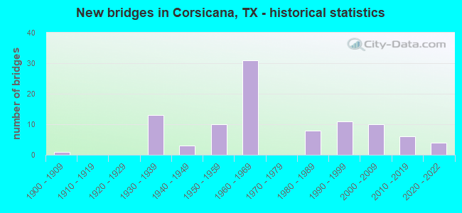
- New bridges - historical statistics
- 11900-1909
- 131930-1939
- 31940-1949
- 101950-1959
- 311960-1969
- 81980-1989
- 111990-1999
- 102000-2009
- 62010-2019
- 42020-2022
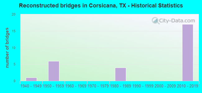
- Reconstructed bridges - Historical Statistics
- 11940-1949
- 61950-1959
- 01960-1969
- 01970-1979
- 41980-1989
- 01990-1999
- 02000-2009
- 172010-2019
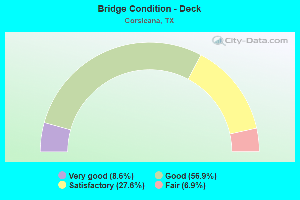
- Bridge Condition - Deck
- 8.6%Very good
- 56.9%Good
- 27.6%Satisfactory
- 6.9%Fair
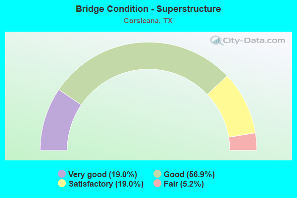
- Bridge Condition - Superstructure
- 19.0%Very good
- 56.9%Good
- 19.0%Satisfactory
- 5.2%Fair
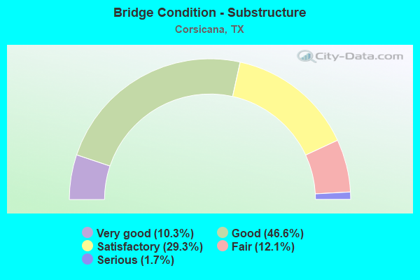
- Bridge Condition - Substructure
- 10.3%Very good
- 46.6%Good
- 29.3%Satisfactory
- 12.1%Fair
- 1.7%Serious
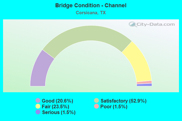
- Bridge Condition - Channel
- 20.6%Good
- 52.9%Satisfactory
- 23.5%Fair
- 1.5%Poor
- 1.5%Serious
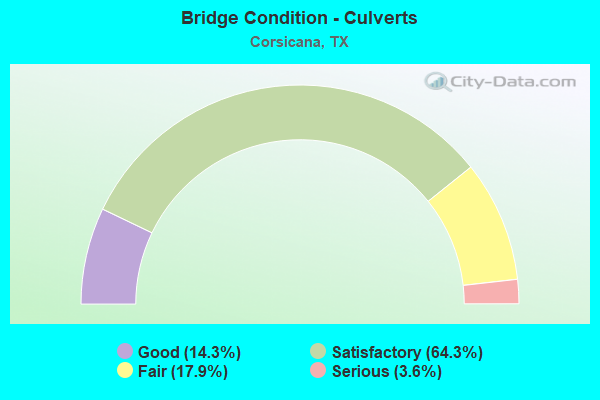
- Bridge Condition - Culverts
- 14.3%Good
- 64.3%Satisfactory
- 17.9%Fair
- 3.6%Serious
Find on map >> Show street view
Structure Number: 181750LF4439001, Location: 0.45 MI NW OF SH 22 (Lat: 32.092750, Lng: -96.490661), Route carried "on" structure: City street , Year Built: 1996, Status: Open, Structure Length: 1.49m (4.89ft), Average Daily Traffic: 173 (year 2019), Truck Traffic: 3%, Average Future Daily Traffic: 173 (year 2039), Features Intersected: TRIB POST OAK CRK, Facility Carried by Structure: N 29TH ST
Minimum Vertical Clearance: 30+ m (98+ ft), Kilometerpoint: 0.724, Lanes on structure: 2, Owner: City or Municipal Highway Agency, Approaching Roadway Width: 8.8m (28.9ft), Skew: 1 degrees, Material/Design: Steel, Design/Construction: Culvert, Number Of Spans In Main Unit: 5, Length of Maximum Span: 2.4m (7.9ft), Curb-To-Curb Width: 8.9m (29.2ft), Out-to-Out Width: 13.4m (44.0ft)
Condition: Channel: Satisfactory, Culverts: Serious, Operating Rating: 30.8 metric tons, Method Used To Determine Operating Rating: Load Factor (LF), Inventory Rating: 18.1 metric tons, Method Used To Determine Inventory Rating: Load Factor (LF), Structural Evaluation: High priority of corrective action, Deck Geometry: Equal to present minimum criteria, Waterway Adequacy: Better than present minimum criteria, Approach Roadway Alignment: Equal to present desirable criteria, Bridge Posting: Required (Relationship of Operating Rating to Maximum Legal Load: 10.0 - 19.9% below), Designated Inspection Frequency: Every 24 months, Inspection Date: June 2021, Wearing Surface/Protective System: Wearing Surface: Monolithic Concrete
Find on map >> Show street view
Structure Number: 181750LF4461001, Location: 0.30 MI SE OF ROANE RD (Lat: 32.103039, Lng: -96.455769), Route carried "on" structure: City street , Year Built: 1990, Status: Open, Structure Length: 1.28m (4.20ft), Average Daily Traffic: 173 (year 2019), Truck Traffic: 3%, Average Future Daily Traffic: 173 (year 2039), Features Intersected: POST OAK CREEK, Facility Carried by Structure: N BUNERT ST
Minimum Vertical Clearance: 30+ m (98+ ft), Kilometerpoint: 0.483, Lanes on structure: 2, Owner: City or Municipal Highway Agency, Approaching Roadway Width: 6.7m (22.0ft), Skew: 2 degrees, Material/Design: Steel, Design/Construction: Culvert, Number Of Spans In Main Unit: 5, Length of Maximum Span: 2.1m (6.9ft), Curb-To-Curb Width: 10.3m (33.8ft), Out-to-Out Width: 13.5m (44.3ft)
Condition: Channel: Satisfactory, Culverts: Satisfactory, Operating Rating: 39.9 metric tons, Method Used To Determine Operating Rating: Load Factor (LF), Inventory Rating: 23.6 metric tons, Method Used To Determine Inventory Rating: Load Factor (LF), Structural Evaluation: Equal to present minimum criteria, Deck Geometry: Better than present minimum criteria, Waterway Adequacy: Meets minimum limits, Approach Roadway Alignment: Equal to present desirable criteria, Designated Inspection Frequency: Every 24 months, Inspection Date: June 2021, Wearing Surface/Protective System: Wearing Surface: Monolithic Concrete
Find on map >> Show street view
Structure Number: 181750009206172, Location: 2.65 MI N OF SH 31 (Lat: 32.134281, Lng: -96.456297), Route carried "under" structure: Interstate 45, Year Built: 1964, Structure Length: 0. m, Average Daily Traffic: 35,560 (year 2013), Truck Traffic: 23%, Features Intersected: IH 45, Facility Carried by Structure: NE CR 100
Minimum Vertical Clearance: 5.28m (17.32ft), Kilometerpoint: 38.425, Lanes on structure: 2, Lanes under structure: 6, Material/Design: Prestressed concrete, Design/Construction: Stringer/Multi-beam, Length of Maximum Span: 18.3m (60.0ft)
Find on map >> Show street view
Structure Number: 181750009206176, Location: 1.25 MI N OF SH 31 (Lat: 32.116153, Lng: -96.445122), Route carried "under" structure: Interstate 45, Year Built: 1964, Structure Length: 0. m, Average Daily Traffic: 33,630 (year 2013), Truck Traffic: 23%, Features Intersected: IH 45, Facility Carried by Structure: WEST ROANE RD
Minimum Vertical Clearance: 5.18m (16.99ft), Kilometerpoint: 36.147, Lanes on structure: 2, Lanes under structure: 6, Material/Design: Prestressed concrete, Design/Construction: Stringer/Multi-beam, Length of Maximum Span: 19.8m (65.0ft)
Find on map >> Show street view
Structure Number: 181750009206177, Location: 0.60 MI N OF SH 31 (Lat: 32.106211, Lng: -96.442858), Route carried "under" structure: Interstate 45, Year Built: 1964, Structure Length: 0. m, Average Daily Traffic: 33,630 (year 2013), Truck Traffic: 23%, Features Intersected: IH 45, Facility Carried by Structure: COUNTY RD
Minimum Vertical Clearance: 5.16m (16.93ft), Kilometerpoint: 35.042, Lanes on structure: 2, Lanes under structure: 4, Material/Design: Prestressed concrete, Design/Construction: Stringer/Multi-beam, Length of Maximum Span: 19.8m (65.0ft)
Find on map >> Show street view
Structure Number: 18175000920618, Location: IH 45 AT SH 31 (Lat: 32.098158, Lng: -96.440981), Route carried "under" structure: State highway 31, Year Built: 1964, Structure Length: 0. m, Average Daily Traffic: 14,460 (year 2013), Truck Traffic: 11%, Features Intersected: SH 31, Facility Carried by Structure: IH 45 NB
Minimum Vertical Clearance: 4.98m (16.34ft), Kilometerpoint: 1.876, Lanes on structure: 2, Lanes under structure: 4, Material/Design: Prestressed concrete, Design/Construction: Stringer/Multi-beam, Length of Maximum Span: 13.7m (44.9ft)
Find on map >> Show street view
Structure Number: 181750009206181, Location: IH 45 AT SH 31 (Lat: 32.098189, Lng: -96.441200), Route carried "under" structure: State highway 31, Year Built: 1964, Structure Length: 0. m, Average Daily Traffic: 13,580 (year 2013), Truck Traffic: 16%, Features Intersected: SH 31, Facility Carried by Structure: IH 45 SB
Minimum Vertical Clearance: 5.13m (16.83ft), Kilometerpoint: 1.852, Lanes on structure: 2, Lanes under structure: 4, Material/Design: Prestressed concrete, Design/Construction: Stringer/Multi-beam, Length of Maximum Span: 13.7m (44.9ft)
Find on map >> Show street view
Structure Number: 181750009213352, Location: BUS 45 AT SH 31 (Lat: 32.091500, Lng: -1000.677775), Route carried "under" structure: State highway 31, Year Built: 1999, Structure Length: 0. m, Average Daily Traffic: 7,200 (year 2016), Truck Traffic: 10%, Features Intersected: SH 31 & UPRR, Facility Carried by Structure: BUS 45
Minimum Vertical Clearance: 7.54m (24.74ft), Kilometerpoint: 1.856, Lanes on structure: 4, Lanes under structure: 6, Material/Design: Prestressed concrete, Design/Construction: Stringer/Multi-beam, Length of Maximum Span: 30.5m (100.1ft)
Find on map >> Show street view
Structure Number: 181750009301053, Location: 2.85 MI S OF SH 31 (Lat: 32.059897, Lng: -96.452028), Route carried "under" structure: City street 15, Year Built: 1958, Structure Length: 0. m, Average Daily Traffic: 350 (year 2012), Truck Traffic: 10%, Features Intersected: 15th Street, Facility Carried by Structure: IH 45 SB ML
Minimum Vertical Clearance: 4.67m (15.32ft), Kilometerpoint: 25.038, Lanes on structure: 3, Lanes under structure: 2, Material/Design: Concrete, Design/Construction: Stringer/Multi-beam, Length of Maximum Span: 9.1m (29.9ft)
Find on map >> Show street view
Structure Number: 181750009301054, Location: 2.85 MI S OF SH 31 (Lat: 32.059953, Lng: -96.451794), Route carried "under" structure: City street 15, Year Built: 1958, Structure Length: 0. m, Average Daily Traffic: 350 (year 2012), Truck Traffic: 10%, Features Intersected: 15th Street, Facility Carried by Structure: IH 45 NB ML
Minimum Vertical Clearance: 5.08m (16.67ft), Kilometerpoint: 25.038, Lanes on structure: 3, Lanes under structure: 2, Material/Design: Concrete, Design/Construction: Stringer/Multi-beam, Length of Maximum Span: 9.1m (29.9ft)
Find on map >> Show street view
Structure Number: 181750009301076, Location: JCT OF US287 (Lat: 32.074089, Lng: -96.445183), Route carried "under" structure: US 287, Year Built: 1964, Structure Length: 0. m, Average Daily Traffic: 12,390 (year 2013), Truck Traffic: 8%, Features Intersected: US 287, Facility Carried by Structure: IH 45
Minimum Vertical Clearance: 4.88m (16.01ft), Kilometerpoint: 1.516, Lanes on structure: 6, Lanes under structure: 4, Material/Design: Prestressed concrete, Design/Construction: Stringer/Multi-beam, Length of Maximum Span: 14.3m (46.9ft)
Find on map >> Show street view
Structure Number: 181750009301268, Location: IH 45 SB AT BUS 45 NB (Lat: 32.065158, Lng: -96.452103), Route carried "under" structure: State highway 45, Year Built: 2019, Structure Length: 0. m, Average Daily Traffic: 17,400 (year 2018), Truck Traffic: 15%, Features Intersected: IH 45 SB AT BUS 45 NB
Minimum Vertical Clearance: 5.11m (16.77ft), Kilometerpoint: 0.000, Lanes on structure: 3, Lanes under structure: 1, Material/Design: Prestressed concrete, Design/Construction: Stringer/Multi-beam, Length of Maximum Span: 38.1m (125.0ft)
Find on map >> Show street view
Structure Number: 181750009301269, Location: 2.25 MI S OF US 287 (Lat: 32.043375, Lng: -96.447333), Route carried "under" structure: State highway 31, Year Built: 2020, Structure Length: 0. m, Average Daily Traffic: 8,100 (year 2013), Truck Traffic: 10%, Features Intersected: SH 31 RELIEF ROUTE, Facility Carried by Structure: IH 45
Minimum Vertical Clearance: 5.13m (16.83ft), Kilometerpoint: 0.002, Lanes on structure: 6, Lanes under structure: 4, Material/Design: Prestressed concrete, Design/Construction: Stringer/Multi-beam, Length of Maximum Span: 36.6m (120.1ft)