Bridge Statistics for Dalton, Georgia (GA)
Condition, Traffic, Stress, Structural Evaluation, Project Costs
- National Bridge Inventory (NBI) Statistics
- 97Number of bridges
- 1,450ft / 442mTotal length
- $164,151,000Total costs
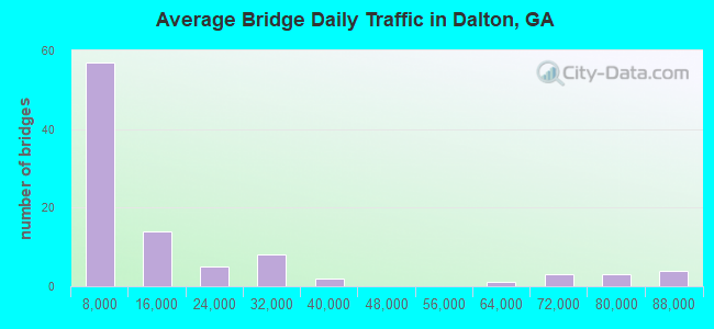
- 1,531,030Total average daily traffic
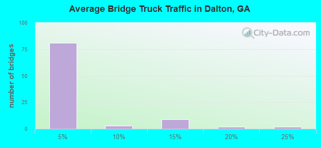
- 46,666Total average daily truck traffic
- National Bridge Inventory (NBI) Registered Bridges for Dalton
- No street view available for this location
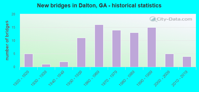
- New bridges - historical statistics
- 51920-1929
- 11930-1939
- 21940-1949
- 111950-1959
- 161960-1969
- 141970-1979
- 131980-1989
- 151990-1999
- 52000-2009
- 42010-2019
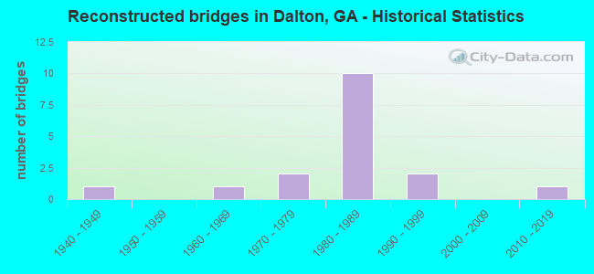
- Reconstructed bridges - Historical Statistics
- 11940-1949
- 01950-1959
- 11960-1969
- 21970-1979
- 101980-1989
- 21990-1999
- 02000-2009
- 12010-2019
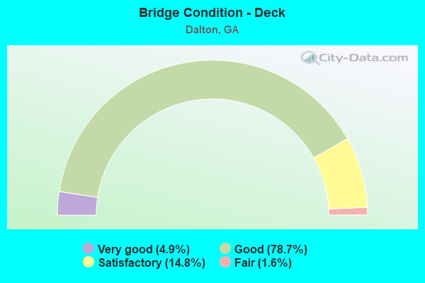
- Bridge Condition - Deck
- 4.9%Very good
- 78.7%Good
- 14.8%Satisfactory
- 1.6%Fair
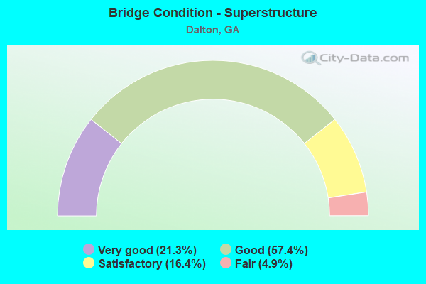
- Bridge Condition - Superstructure
- 21.3%Very good
- 57.4%Good
- 16.4%Satisfactory
- 4.9%Fair
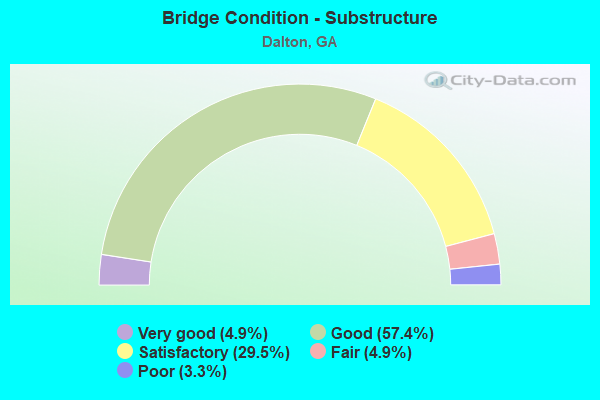
- Bridge Condition - Substructure
- 4.9%Very good
- 57.4%Good
- 29.5%Satisfactory
- 4.9%Fair
- 3.3%Poor
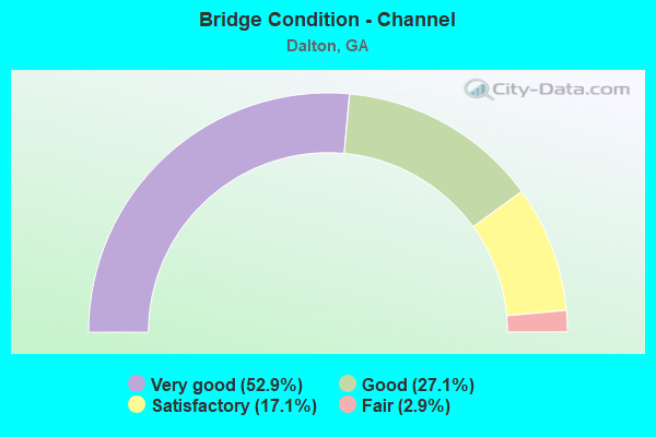
- Bridge Condition - Channel
- 52.9%Very good
- 27.1%Good
- 17.1%Satisfactory
- 2.9%Fair
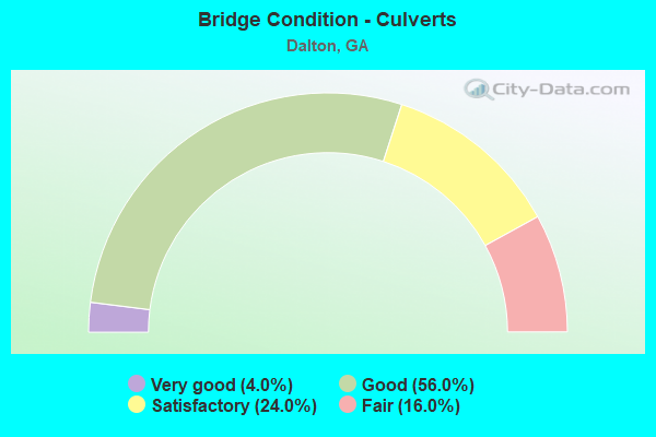
- Bridge Condition - Culverts
- 4.0%Very good
- 56.0%Good
- 24.0%Satisfactory
- 16.0%Fair
Find on map >> Show street view
Structure Number: 710061, Location: APP 8 MI SE OF MOULTRIE (Lat: 31.058078, Lng: -83.709758), Route carried "on" structure: County highway 1209, Year Built: 1956, Status: Open, Structure Length: 3.69m (12.11ft), Average Daily Traffic: 1,000 (year 2011), Truck Traffic: 1%, Average Future Daily Traffic: 1,500 (year 2031), Design Load: H 15, Features Intersected: HOG CREEK, Facility Carried by Structure: TALLOKAS ROAD
Minimum Vertical Clearance: 30+ m (98+ ft), Kilometerpoint: 3.219, Lanes on structure: 2, Base Highway Network: Yes, Owner: County Highway Agency, Approaching Roadway Width: 6.1m (20.0ft), Material/Design: Prestressed concrete, Design/Construction: Channel Beam, Number Of Spans In Main Unit: 4, Length of Maximum Span: 9.1m (29.9ft), Curb or Sidewalk Widths: Left: 0.2m (0.7ft), Right: 0.2m (0.7ft), Curb-To-Curb Width: 7.3m (24.0ft), Out-to-Out Width: 7.8m (25.6ft)
Condition: Deck: Good, Superstructure: Good, Substructure: Satisfactory, Channel: Fair, Operating Rating: 32.6 metric tons, Method Used To Determine Operating Rating: Load Factor (LF), Inventory Rating: 15.4 metric tons, Method Used To Determine Inventory Rating: Load Factor (LF), Structural Evaluation: Meets minimum limits, Deck Geometry: Meets minimum limits, Waterway Adequacy: Equal to present minimum criteria, Approach Roadway Alignment: Equal to present minimum criteria, Length Of Structure Improvement: 10.09m (33.10ft), Designated Inspection Frequency: Every 24 months, Underwater Inspection Frequency: Every 60 months, Inspection Date: January 2021, Underwater Inspection Date: March 2018, Bridge Improvement Cost: $473,000, Roadway Improvement Cost: $47,000, Total Project Cost: $709,000, Deck Structure Type: Concrete Precast Panels, Wearing Surface/Protective System: Wearing Surface: Bituminous
Find on map >> Show street view
Structure Number: 710067, Location: APP .5 MI N OF ELLENTON (Lat: 31.185719, Lng: -83.585889), Route carried "on" structure: County highway 1754, Year Built: 1959, Status: Open, Structure Length: 0.79m (2.59ft), Average Daily Traffic: 1,680 (year 2011), Truck Traffic: 1%, Average Future Daily Traffic: 2,520 (year 2031), Design Load: H 15, Features Intersected: BUCK CREEK, Facility Carried by Structure: ELLENTON-OMEGA RD
Minimum Vertical Clearance: 30+ m (98+ ft), Kilometerpoint: 3.219, Lanes on structure: 2, Base Highway Network: Yes, Owner: County Highway Agency, Approaching Roadway Width: 6.1m (20.0ft), Material/Design: Concrete, Design/Construction: Culvert, Number Of Spans In Main Unit: 3, Length of Maximum Span: 2.4m (7.9ft)
Condition: Channel: Good, Culverts: Satisfactory, Operating Rating: 41.7 metric tons, Method Used To Determine Operating Rating: Field evaluation and documented engineering judgment, Inventory Rating: 24.4 metric tons, Method Used To Determine Inventory Rating: Field evaluation and documented engineering judgment, Structural Evaluation: Equal to present minimum criteria, Waterway Adequacy: Equal to present desirable criteria, Approach Roadway Alignment: Equal to present minimum criteria, Designated Inspection Frequency: Every 24 months, Inspection Date: January 2021, Bridge Improvement Cost: $102,000, Roadway Improvement Cost: $10,000, Total Project Cost: $152,000
Find on map >> Show street view
Structure Number: 710092, Location: APP 8 MI E OF MOULTRIE (Lat: 31.173164, Lng: -83.657583), Route carried "on" structure: State highway 37, Year Built: 1993, Status: Open, Structure Length: 2.74m (8.99ft), Average Daily Traffic: 3,170 (year 2011), Truck Traffic: 1%, Average Future Daily Traffic: 4,755 (year 2031), Design Load: HS 20+Mod, Features Intersected: REEDY CREEK
Minimum Vertical Clearance: 30+ m (98+ ft), Kilometerpoint: 37.015, Lanes on structure: 2, Base Highway Network: Yes, Owner: State Highway Agency, Approaching Roadway Width: 8.5m (27.9ft), Material/Design: Concrete, Design/Construction: Tee Beam, Number Of Spans In Main Unit: 3, Length of Maximum Span: 9.1m (29.9ft), Curb-To-Curb Width: 12.2m (40.0ft), Out-to-Out Width: 13.2m (43.3ft)
Condition: Deck: Good, Superstructure: Good, Substructure: Good, Channel: Very good, Operating Rating: 60.7 metric tons, Method Used To Determine Operating Rating: Load Factor (LF), Inventory Rating: 36.2 metric tons, Method Used To Determine Inventory Rating: Load Factor (LF), Structural Evaluation: Better than present minimum criteria, Deck Geometry: Equal to present minimum criteria, Waterway Adequacy: Equal to present desirable criteria, Approach Roadway Alignment: Equal to present desirable criteria, Designated Inspection Frequency: Every 24 months, Inspection Date: Febuary 2021, Bridge Improvement Cost: $352,000, Roadway Improvement Cost: $35,000, Total Project Cost: $527,000, Deck Structure Type: Concrete Cast-file-Place
Find on map >> Show street view
Structure Number: 2130037, Location: 5.4 MI S OF SPRING PLACE (Lat: 34.681278, Lng: -84.839789), Route carried "on" structure: County highway 297, Year Built: 1979, Status: Open, Structure Length: 9.75m (31.99ft), Average Daily Traffic: 490 (year 2012), Truck Traffic: 1%, Average Future Daily Traffic: 735 (year 2032), Design Load: HS 20, Features Intersected: HOLLY CREEK, Facility Carried by Structure: FOX BRIDGE ROAD
Minimum Vertical Clearance: 30+ m (98+ ft), Kilometerpoint: 3.219, Lanes on structure: 2, Owner: County Highway Agency, Approaching Roadway Width: 6.7m (22.0ft), Material/Design: Concrete, Design/Construction: Tee Beam, Number Of Spans In Main Unit: 8, Length of Maximum Span: 12.2m (40.0ft), Curb-To-Curb Width: 12.2m (40.0ft), Out-to-Out Width: 13.2m (43.3ft)
Condition: Deck: Good, Superstructure: Good, Substructure: Satisfactory, Channel: Very good, Operating Rating: 24.4 metric tons, Method Used To Determine Operating Rating: Allowable Stress (AS), Inventory Rating: 18.1 metric tons, Method Used To Determine Inventory Rating: Allowable Stress (AS), Structural Evaluation: Somewhat better than minimum adequacy, Deck Geometry: Equal to present desirable criteria, Waterway Adequacy: Equal to present desirable criteria, Approach Roadway Alignment: Equal to present desirable criteria, Designated Inspection Frequency: Every 24 months, Underwater Inspection Frequency: Every 60 months, Inspection Date: Febuary 2022, Underwater Inspection Date: August 2021, Bridge Improvement Cost: $1,250,000, Roadway Improvement Cost: $125,000, Total Project Cost: $1,875,000, Deck Structure Type: Concrete Cast-file-Place
Find on map >> Show street view
Structure Number: 2130038, Location: MURRAY-WHITFIELD CO LINE (Lat: 34.708658, Lng: -84.863969), Route carried "on" structure: County highway 556, Year Built: 1975, Status: Open, Structure Length: 12.80m (41.99ft), Average Daily Traffic: 2,630 (year 2012), Truck Traffic: 1%, Average Future Daily Traffic: 3,945 (year 2032), Design Load: HS 20, Features Intersected: CONASAUGA RIVER, Facility Carried by Structure: AIRPORT ROAD
Minimum Vertical Clearance: 30+ m (98+ ft), Kilometerpoint: 6.437, Lanes on structure: 2, Owner: County Highway Agency, Approaching Roadway Width: 7.3m (24.0ft), Material/Design: Prestressed concrete, Design/Construction: Stringer/Multi-beam, Number Of Spans In Main Unit: 6, Length of Maximum Span: 21.3m (69.9ft), Curb or Sidewalk Widths: Left: 0.2m (0.7ft), Right: 0.2m (0.7ft), Curb-To-Curb Width: 11.9m (39.0ft), Out-to-Out Width: 13.0m (42.7ft)
Condition: Deck: Good, Superstructure: Good, Substructure: Good, Channel: Good, Operating Rating: 44.4 metric tons, Method Used To Determine Operating Rating: Load Factor (LF), Inventory Rating: 26.3 metric tons, Method Used To Determine Inventory Rating: Load Factor (LF), Structural Evaluation: Equal to present minimum criteria, Deck Geometry: Somewhat better than minimum adequacy, Waterway Adequacy: Superior to present desirable criteria, Approach Roadway Alignment: Equal to present desirable criteria, Designated Inspection Frequency: Every 24 months, Underwater Inspection Frequency: Every 60 months, Inspection Date: Febuary 2022, Underwater Inspection Date: August 2021, Bridge Improvement Cost: $1,641,000, Roadway Improvement Cost: $164,000, Total Project Cost: $2,462,000, Deck Structure Type: Concrete Cast-file-Place
Find on map >> Show street view
Structure Number: 213502, Location: 5.1 MI SW OF CHATSWORTH (Lat: 34.736697, Lng: -84.857619), Route carried "on" structure: County highway 109, Year Built: 1980, Status: Open, Structure Length: 8.78m (28.81ft), Average Daily Traffic: 950 (year 2012), Truck Traffic: 1%, Average Future Daily Traffic: 1,425 (year 2032), Design Load: HS 15, Features Intersected: CONASAUGA RIVER, Facility Carried by Structure: TIBBS BRIDGE ROAD
Minimum Vertical Clearance: 30+ m (98+ ft), Kilometerpoint: 0.000, Lanes on structure: 2, Owner: County Highway Agency, Approaching Roadway Width: 7.3m (24.0ft), Material/Design: Prestressed concrete, Design/Construction: Stringer/Multi-beam, Number Of Spans In Main Unit: 4, Length of Maximum Span: 21.9m (71.9ft), Curb-To-Curb Width: 9.1m (29.9ft), Out-to-Out Width: 10.1m (33.1ft)
Condition: Deck: Good, Superstructure: Good, Substructure: Good, Channel: Good, Operating Rating: 63.5 metric tons, Method Used To Determine Operating Rating: Load Factor (LF), Inventory Rating: 38.1 metric tons, Method Used To Determine Inventory Rating: Load Factor (LF), Structural Evaluation: Better than present minimum criteria, Deck Geometry: Equal to present minimum criteria, Waterway Adequacy: Equal to present desirable criteria, Approach Roadway Alignment: Equal to present desirable criteria, Designated Inspection Frequency: Every 24 months, Underwater Inspection Frequency: Every 60 months, Inspection Date: Febuary 2022, Underwater Inspection Date: August 2021, Bridge Improvement Cost: $1,125,000, Roadway Improvement Cost: $113,000, Total Project Cost: $1,688,000, Deck Structure Type: Concrete Cast-file-Place
Find on map >> Show street view
Structure Number: 2135043, Location: 5.1 MI SW OF CHATSWORTH (Lat: 34.707489, Lng: -84.824208), Route carried "on" structure: County highway 109, Year Built: 2007, Status: Open, Structure Length: 0.82m (2.69ft), Average Daily Traffic: 950 (year 2012), Truck Traffic: 1%, Average Future Daily Traffic: 1,425 (year 2032), Design Load: HS 20+Mod, Features Intersected: BULLPEN BRANCH, Facility Carried by Structure: BROWN BRIDGE ROAD
Minimum Vertical Clearance: 30+ m (98+ ft), Kilometerpoint: 4.828, Lanes on structure: 2, Owner: County Highway Agency, Approaching Roadway Width: 6.7m (22.0ft), Skew: 4 degrees, Material/Design: Concrete, Design/Construction: Culvert, Number Of Spans In Main Unit: 2, Length of Maximum Span: 4.0m (13.1ft)
Condition: Channel: Good, Culverts: Good, Operating Rating: 55.3 metric tons, Method Used To Determine Operating Rating: Field evaluation and documented engineering judgment, Inventory Rating: 32.6 metric tons, Method Used To Determine Inventory Rating: Field evaluation and documented engineering judgment, Structural Evaluation: Better than present minimum criteria, Waterway Adequacy: Equal to present desirable criteria, Approach Roadway Alignment: Equal to present desirable criteria, Designated Inspection Frequency: Every 24 months, Inspection Date: Febuary 2022, Bridge Improvement Cost: $109,000, Roadway Improvement Cost: $11,000, Total Project Cost: $164,000
Find on map >> Show street view
Structure Number: 3130005, Location: 6.8 MI S OF DALTON (Lat: 34.673539, Lng: -84.982608), Route carried "on" structure: US 41, Year Built: 1949, Status: Open, Structure Length: 3.96m (12.99ft), Average Daily Traffic: 7,780 (year 2011), Truck Traffic: 1%, Average Future Daily Traffic: 11,670 (year 2031), Design Load: H 15, Features Intersected: SWAMP CREEK
Minimum Vertical Clearance: 30+ m (98+ ft), Kilometerpoint: 8.047, Lanes on structure: 2, Base Highway Network: Yes, Owner: State Highway Agency, Approaching Roadway Width: 9.1m (29.9ft), Material/Design: Concrete, Design/Construction: Tee Beam, Number Of Spans In Main Unit: 5, Length of Maximum Span: 7.9m (25.9ft), Curb or Sidewalk Widths: Left: 0.6m (2.0ft), Right: 0.6m (2.0ft), Curb-To-Curb Width: 9.1m (29.9ft), Out-to-Out Width: 10.8m (35.4ft)
Condition: Deck: Satisfactory, Superstructure: Satisfactory, Substructure: Satisfactory, Channel: Good, Operating Rating: 39.0 metric tons, Method Used To Determine Operating Rating: Load Factor (LF), Inventory Rating: 23.5 metric tons, Method Used To Determine Inventory Rating: Load Factor (LF), Structural Evaluation: Somewhat better than minimum adequacy, Deck Geometry: High priority of corrective action, Waterway Adequacy: Superior to present desirable criteria, Approach Roadway Alignment: Equal to present desirable criteria, Length Of Structure Improvement: 10.39m (34.09ft), Designated Inspection Frequency: Every 24 months, Inspection Date: June 2020, Bridge Improvement Cost: $508,000, Roadway Improvement Cost: $51,000, Total Project Cost: $762,000, Deck Structure Type: Concrete Cast-file-Place
Find on map >> Show street view
Structure Number: 3130007, Location: 5.9 MI S OF DALTON (Lat: 34.687789, Lng: -84.990219), Route carried "on" structure: US 41, Year Built: 1947, Status: Open, Structure Length: 6.07m (19.91ft), Average Daily Traffic: 7,240 (year 2011), Truck Traffic: 12%, Average Future Daily Traffic: 10,860 (year 2031), Design Load: H 15, Features Intersected: NS RAILROAD (719716U)
Minimum Vertical Clearance: 30+ m (98+ ft), Kilometerpoint: 8.047, Lanes on structure: 2, Base Highway Network: Yes, Owner: State Highway Agency, Approaching Roadway Width: 9.1m (29.9ft), Skew: 2 degrees, Material/Design: Concrete, Design/Construction: Tee Beam, Number Of Spans In Main Unit: 5, Length of Maximum Span: 14.3m (46.9ft), Curb or Sidewalk Widths: Left: 0.6m (2.0ft), Right: 0.6m (2.0ft), Curb-To-Curb Width: 9.1m (29.9ft), Out-to-Out Width: 10.9m (35.8ft)
Condition: Deck: Satisfactory, Superstructure: Satisfactory, Substructure: Satisfactory, Operating Rating: 44.4 metric tons, Method Used To Determine Operating Rating: Load Factor (LF), Inventory Rating: 26.3 metric tons, Method Used To Determine Inventory Rating: Load Factor (LF), Structural Evaluation: Equal to present minimum criteria, Deck Geometry: Meets minimum limits, Underclear: Meets minimum limits, Approach Roadway Alignment: Equal to present desirable criteria, Length Of Structure Improvement: 12.53m (41.11ft), Designated Inspection Frequency: Every 24 months, Inspection Date: June 2020, Bridge Improvement Cost: $778,000, Roadway Improvement Cost: $78,000, Total Project Cost: $1,166,000, Deck Structure Type: Concrete Cast-file-Place
Find on map >> Show street view
Structure Number: 3130008, Location: 2.9 MI S OF DALTON (Lat: 34.731250, Lng: -84.977428), Route carried "on" structure: County highway 1177, Year Built: 1927, Year Reconstructed: 1949, Status: Open, Structure Length: 3.66m (12.01ft), Average Daily Traffic: 7,970 (year 2011), Truck Traffic: 9%, Average Future Daily Traffic: 11,955 (year 2031), Design Load: H 15, Features Intersected: DROWNING BEAR CREEK, Facility Carried by Structure: OLD SR 3
Minimum Vertical Clearance: 30+ m (98+ ft), Kilometerpoint: 4.828, Lanes on structure: 2, Base Highway Network: Yes, Owner: County Highway Agency, Approaching Roadway Width: 8.5m (27.9ft), Material/Design: Concrete, Design/Construction: Tee Beam, Number Of Spans In Main Unit: 4, Length of Maximum Span: 9.1m (29.9ft), Curb or Sidewalk Widths: Left: 0.6m (2.0ft), Right: 0.6m (2.0ft), Curb-To-Curb Width: 8.5m (27.9ft), Out-to-Out Width: 10.2m (33.5ft)
Condition: Deck: Good, Superstructure: Good, Substructure: Good, Channel: Satisfactory, Operating Rating: 50.8 metric tons, Method Used To Determine Operating Rating: Load Factor (LF), Inventory Rating: 30.8 metric tons, Method Used To Determine Inventory Rating: Load Factor (LF), Structural Evaluation: Better than present minimum criteria, Deck Geometry: High priority of replacement, Waterway Adequacy: Superior to present desirable criteria, Approach Roadway Alignment: Equal to present desirable criteria, Length Of Structure Improvement: 10.09m (33.10ft), Designated Inspection Frequency: Every 24 months, Inspection Date: June 2020, Bridge Improvement Cost: $469,000, Roadway Improvement Cost: $47,000, Total Project Cost: $703,000, Deck Structure Type: Concrete Cast-file-Place, Wearing Surface/Protective System: Wearing Surface: Bituminous
Find on map >> Show street view
Structure Number: 3130009, Location: 2 MI S OF DALTON (Lat: 34.744708, Lng: -84.972039), Route carried "on" structure: County highway 1177, Year Built: 1927, Status: Open, Structure Length: 1.28m (4.20ft), Average Daily Traffic: 10,300 (year 2011), Truck Traffic: 1%, Average Future Daily Traffic: 15,450 (year 2031), Design Load: H 15, Features Intersected: TAR CREEK, Facility Carried by Structure: OLD US 41
Minimum Vertical Clearance: 30+ m (98+ ft), Kilometerpoint: 6.437, Lanes on structure: 2, Base Highway Network: Yes, Owner: County Highway Agency, Approaching Roadway Width: 7.9m (25.9ft), Skew: 4 degrees, Material/Design: Concrete, Design/Construction: Culvert, Number Of Spans In Main Unit: 3, Length of Maximum Span: 4.0m (13.1ft), Curb-To-Curb Width: 9.2m (30.2ft), Out-to-Out Width: 10.1m (33.1ft)
Condition: Channel: Satisfactory, Culverts: Fair, Operating Rating: 41.7 metric tons, Method Used To Determine Operating Rating: Field evaluation and documented engineering judgment, Inventory Rating: 24.4 metric tons, Method Used To Determine Inventory Rating: Field evaluation and documented engineering judgment, Structural Evaluation: Somewhat better than minimum adequacy, Deck Geometry: High priority of corrective action, Waterway Adequacy: Equal to present desirable criteria, Approach Roadway Alignment: Equal to present desirable criteria, Length Of Structure Improvement: 7.71m (25.30ft), Designated Inspection Frequency: Every 24 months, Inspection Date: May 2020, Bridge Improvement Cost: $164,000, Roadway Improvement Cost: $16,000, Total Project Cost: $246,000
Find on map >> Show street view
Structure Number: 313001, Location: AT SOUTH DALTON CITY LIMT (Lat: 34.751658, Lng: -84.969319), Route carried "on" structure: County highway 1177, Year Built: 1927, Status: Open, Structure Length: 1.07m (3.51ft), Average Daily Traffic: 11,830 (year 2011), Truck Traffic: 1%, Average Future Daily Traffic: 17,745 (year 2031), Design Load: H 15, Features Intersected: NORTH FORK TAR CREEK, Facility Carried by Structure: OLD US 41
Minimum Vertical Clearance: 30+ m (98+ ft), Kilometerpoint: 6.437, Lanes on structure: 2, Base Highway Network: Yes, Owner: County Highway Agency, Approaching Roadway Width: 7.0m (23.0ft), Skew: 3 degrees, Material/Design: Concrete, Design/Construction: Culvert, Number Of Spans In Main Unit: 3, Length of Maximum Span: 3.4m (11.2ft), Curb-To-Curb Width: 9.4m (30.8ft), Out-to-Out Width: 10.4m (34.1ft)
Condition: Channel: Satisfactory, Culverts: Good, Operating Rating: 41.7 metric tons, Method Used To Determine Operating Rating: Field evaluation and documented engineering judgment, Inventory Rating: 24.4 metric tons, Method Used To Determine Inventory Rating: Field evaluation and documented engineering judgment, Structural Evaluation: Equal to present minimum criteria, Deck Geometry: High priority of corrective action, Waterway Adequacy: Superior to present desirable criteria, Approach Roadway Alignment: Equal to present desirable criteria, Length Of Structure Improvement: 7.50m (24.61ft), Designated Inspection Frequency: Every 24 months, Inspection Date: June 2020, Bridge Improvement Cost: $137,000, Roadway Improvement Cost: $14,000, Total Project Cost: $205,000
Find on map >> Show street view
Structure Number: 3130011, Location: IN NW DALTON (Lat: 34.794458, Lng: -84.997828), Route carried "on" structure: US 41, Year Built: 1925, Year Reconstructed: 1984, Status: Open, Structure Length: 0.76m (2.49ft), Average Daily Traffic: 36,880 (year 2011), Truck Traffic: 1%, Average Future Daily Traffic: 55,320 (year 2031), Design Load: H 15, Features Intersected: MILL CREEK TRIB
Minimum Vertical Clearance: 30+ m (98+ ft), Kilometerpoint: 32.187, Lanes on structure: 4, Base Highway Network: Yes, Owner: State Highway Agency, Approaching Roadway Width: 19.5m (64.0ft), Skew: 3 degrees, Material/Design: Concrete, Design/Construction: Culvert, Number Of Spans In Main Unit: 2, Length of Maximum Span: 3.7m (12.1ft)
Condition: Channel: Very good, Culverts: Good, Structural Evaluation: Better than present minimum criteria, Waterway Adequacy: Superior to present desirable criteria, Approach Roadway Alignment: Equal to present desirable criteria, Designated Inspection Frequency: Every 24 months, Underwater Inspection Frequency: Every 60 months, Inspection Date: June 2020, Underwater Inspection Date: June 2020, Bridge Improvement Cost: $151,000, Roadway Improvement Cost: $15,000, Total Project Cost: $226,000
Find on map >> Show street view
Structure Number: 3130012, Location: 3.7 MI NW OF DALTON (Lat: 34.803228, Lng: -85.021622), Route carried "on" structure: US 41, Year Built: 1955, Year Reconstructed: 1988, Status: Open, Structure Length: 4.57m (14.99ft), Average Daily Traffic: 19,900 (year 2011), Truck Traffic: 1%, Average Future Daily Traffic: 29,850 (year 2031), Design Load: H 15, Features Intersected: MILL CREEK
Minimum Vertical Clearance: 30+ m (98+ ft), Kilometerpoint: 35.406, Lanes on structure: 5, Base Highway Network: Yes, Owner: State Highway Agency, Approaching Roadway Width: 20.7m (67.9ft), Material/Design: Concrete, Design/Construction: Tee Beam, Number Of Spans In Main Unit: 5, Length of Maximum Span: 9.1m (29.9ft), Curb-To-Curb Width: 25.0m (82.0ft), Out-to-Out Width: 26.0m (85.3ft)
Condition: Deck: Good, Superstructure: Satisfactory, Substructure: Good, Channel: Very good, Operating Rating: 41.7 metric tons, Method Used To Determine Operating Rating: Load Factor (LF), Inventory Rating: 24.4 metric tons, Method Used To Determine Inventory Rating: Load Factor (LF), Structural Evaluation: Equal to present minimum criteria, Deck Geometry: Superior to present desirable criteria, Waterway Adequacy: Superior to present desirable criteria, Approach Roadway Alignment: Equal to present desirable criteria, Designated Inspection Frequency: Every 24 months, Inspection Date: May 2020, Bridge Improvement Cost: $1,066,000, Roadway Improvement Cost: $107,000, Total Project Cost: $1,598,000, Deck Structure Type: Concrete Cast-file-Place
Find on map >> Show street view
Structure Number: 3130016, Location: 5.9 MI SW OF DALTON (Lat: 34.689056, Lng: -84.996967), Route carried "on" structure: Ramp State highway 3, Year Built: 1963, Year Reconstructed: 1991, Status: Open, Structure Length: 0.67m (2.20ft), Average Daily Traffic: 20,590 (year 2011), Truck Traffic: 1%, Average Future Daily Traffic: 30,885 (year 2031), Design Load: HS 20+Mod, Features Intersected: LITTLE SWAMP CREEK
Minimum Vertical Clearance: 30+ m (98+ ft), Kilometerpoint: 0.000, Lanes on structure: 5, Base Highway Network: Yes, Owner: State Highway Agency, Approaching Roadway Width: 21.0m (68.9ft), Skew: 1 degrees, Material/Design: Concrete, Design/Construction: Culvert, Number Of Spans In Main Unit: 2, Length of Maximum Span: 3.4m (11.2ft)
Condition: Channel: Satisfactory, Culverts: Good, Operating Rating: 55.3 metric tons, Method Used To Determine Operating Rating: Field evaluation and documented engineering judgment, Inventory Rating: 32.6 metric tons, Method Used To Determine Inventory Rating: Field evaluation and documented engineering judgment, Structural Evaluation: Better than present minimum criteria, Waterway Adequacy: Superior to present desirable criteria, Approach Roadway Alignment: Equal to present desirable criteria, Designated Inspection Frequency: Every 24 months, Inspection Date: June 2020, Bridge Improvement Cost: $156,000, Roadway Improvement Cost: $16,000, Total Project Cost: $234,000
Find on map >> Show street view
Structure Number: 3130018, Location: AT SW DALTON CITY LIMIT (Lat: 34.761028, Lng: -85.001908), Route carried "on" structure: State highway 52, Year Built: 1964, Year Reconstructed: 1980, Status: Open, Structure Length: 6.40m (21.00ft), Average Daily Traffic: 25,590 (year 2011), Truck Traffic: 1%, Average Future Daily Traffic: 38,385 (year 2031), Design Load: HS 20+Mod, Features Intersected: I-75, Facility Carried by Structure: WALNUT AVE.
Minimum Vertical Clearance: 30+ m (98+ ft), Kilometerpoint: 0.000, Lanes on structure: 5, Lanes under structure: 6, Base Highway Network: Yes, Owner: State Highway Agency, Approaching Roadway Width: 20.7m (67.9ft), Material/Design: Steel continuous, Design/Construction: Stringer/Multi-beam, Number Of Spans In Main Unit: 4, Length of Maximum Span: 21.3m (69.9ft), Curb or Sidewalk Widths: Left: 1.8m (5.9ft), Right: 1.8m (5.9ft), Curb-To-Curb Width: 20.7m (67.9ft), Out-to-Out Width: 25.1m (82.3ft)
Condition: Deck: Good, Superstructure: Good, Substructure: Good, Operating Rating: 45.3 metric tons, Method Used To Determine Operating Rating: Allowable Stress (AS), Inventory Rating: 32.6 metric tons, Method Used To Determine Inventory Rating: Allowable Stress (AS), Structural Evaluation: Better than present minimum criteria, Deck Geometry: Somewhat better than minimum adequacy, Underclear: Meets minimum limits, Approach Roadway Alignment: Equal to present desirable criteria, Designated Inspection Frequency: Every 24 months, Inspection Date: June 2020, Other Special Inspection Date: August 2020, Bridge Improvement Cost: $1,492,000, Roadway Improvement Cost: $149,000, Total Project Cost: $2,238,000, Deck Structure Type: Concrete Cast-file-Place, Wearing Surface/Protective System: Wearing Surface: Bituminous
Find on map >> Show street view
Structure Number: 3130019, Location: IN SOUTH DALTON (Lat: 34.761536, Lng: -84.966819), Route carried "on" structure: State highway 52, Year Built: 1975, Status: Open, Structure Length: 22.83m (74.90ft), Average Daily Traffic: 27,120 (year 2011), Truck Traffic: 1%, Average Future Daily Traffic: 40,680 (year 2031), Design Load: HS 20+Mod, Features Intersected: M1501 HAMILTON ST-NS RR
Minimum Vertical Clearance: 30+ m (98+ ft), Kilometerpoint: 3.219, Lanes on structure: 5, Lanes under structure: 2, Base Highway Network: Yes, Owner: State Highway Agency, Approaching Roadway Width: 20.7m (67.9ft), Skew: 9 degrees, Material/Design: Steel, Design/Construction: Stringer/Multi-beam, Number Of Spans In Main Unit: 11, Length of Maximum Span: 23.8m (78.1ft), Curb or Sidewalk Widths: Left: 1.5m (4.9ft), Right: 1.5m (4.9ft), Curb-To-Curb Width: 20.7m (67.9ft), Out-to-Out Width: 24.6m (80.7ft)
Condition: Deck: Good, Superstructure: Good, Substructure: Good, Operating Rating: 46.2 metric tons, Method Used To Determine Operating Rating: Allowable Stress (AS), Inventory Rating: 32.6 metric tons, Method Used To Determine Inventory Rating: Allowable Stress (AS), Structural Evaluation: Better than present minimum criteria, Deck Geometry: Somewhat better than minimum adequacy, Underclear: Meets minimum limits, Approach Roadway Alignment: Equal to present desirable criteria, Designated Inspection Frequency: Every 24 months, Inspection Date: June 2020, Bridge Improvement Cost: $5,321,000, Roadway Improvement Cost: $532,000, Total Project Cost: $7,981,000, Deck Structure Type: Concrete Cast-file-Place
Find on map >> Show street view
Structure Number: 313002, Location: 3 MI E OF DALTON (Lat: 34.778042, Lng: -84.915836), Route carried "on" structure: State highway 52, Year Built: 1969, Year Reconstructed: 1980, Status: Open, Structure Length: 10.58m (34.71ft), Average Daily Traffic: 22,470 (year 2011), Truck Traffic: 1%, Average Future Daily Traffic: 33,705 (year 2031), Design Load: HS 20+Mod, Features Intersected: MILL CREEK
Minimum Vertical Clearance: 30+ m (98+ ft), Kilometerpoint: 9.656, Lanes on structure: 4, Base Highway Network: Yes, Owner: State Highway Agency, Approaching Roadway Width: 15.8m (51.8ft), Material/Design: Steel, Design/Construction: Stringer/Multi-beam, Number Of Spans In Main Unit: 1, Number Of Approach Spans: 9, Length of Maximum Span: 23.5m (77.1ft), Curb or Sidewalk Widths: Left: 1.9m (6.2ft), Right: 1.9m (6.2ft), Curb-To-Curb Width: 15.8m (51.8ft), Out-to-Out Width: 19.7m (64.6ft)
Condition: Deck: Satisfactory, Superstructure: Satisfactory, Substructure: Satisfactory, Channel: Very good, Operating Rating: 40.8 metric tons, Method Used To Determine Operating Rating: Allowable Stress (AS), Inventory Rating: 23.5 metric tons, Method Used To Determine Inventory Rating: Allowable Stress (AS), Structural Evaluation: Somewhat better than minimum adequacy, Deck Geometry: Meets minimum limits, Waterway Adequacy: Superior to present desirable criteria, Approach Roadway Alignment: Equal to present desirable criteria, Designated Inspection Frequency: Every 24 months, Inspection Date: May 2020, Bridge Improvement Cost: $2,095,000, Roadway Improvement Cost: $210,000, Total Project Cost: $3,143,000, Deck Structure Type: Concrete Cast-file-Place, Wearing Surface/Protective System: Wearing Surface: Bituminous
Find on map >> Show street view
Structure Number: 3130021, Location: 4 MI E OF DALTON (Lat: 34.779289, Lng: -84.896758), Route carried "on" structure: US 76, Year Built: 1980, Status: Open, Structure Length: 11.80m (38.71ft), Average Daily Traffic: 30,710 (year 2011), Truck Traffic: 1%, Average Future Daily Traffic: 46,065 (year 2031), Design Load: HS 20+Mod, Features Intersected: COAHULLA CREEK
Minimum Vertical Clearance: 30+ m (98+ ft), Kilometerpoint: 11.265, Lanes on structure: 2, Base Highway Network: Yes, Owner: State Highway Agency, Approaching Roadway Width: 9.8m (32.2ft), Skew: 10 degrees, Material/Design: Steel, Design/Construction: Stringer/Multi-beam, Number Of Spans In Main Unit: 2, Number Of Approach Spans: 9, Length of Maximum Span: 21.3m (69.9ft), Curb-To-Curb Width: 12.8m (42.0ft), Out-to-Out Width: 13.8m (45.3ft)
Condition: Deck: Good, Superstructure: Good, Substructure: Good, Channel: Good, Operating Rating: 48.9 metric tons, Method Used To Determine Operating Rating: Load Factor (LF), Inventory Rating: 29.0 metric tons, Method Used To Determine Inventory Rating: Load Factor (LF), Structural Evaluation: Better than present minimum criteria, Deck Geometry: Equal to present desirable criteria, Waterway Adequacy: Superior to present desirable criteria, Approach Roadway Alignment: Equal to present desirable criteria, Designated Inspection Frequency: Every 24 months, Inspection Date: June 2020, Bridge Improvement Cost: $1,512,000, Roadway Improvement Cost: $151,000, Total Project Cost: $2,268,000, Deck Structure Type: Concrete Cast-file-Place
Find on map >> Show street view
Structure Number: 3130022, Location: 4 MI E OF DALTON (Lat: 34.779539, Lng: -84.896728), Route carried "on" structure: US 76, Year Built: 1969, Year Reconstructed: 1980, Status: Open, Structure Length: 11.80m (38.71ft), Average Daily Traffic: 30,710 (year 2011), Truck Traffic: 1%, Average Future Daily Traffic: 46,065 (year 2031), Design Load: HS 20+Mod, Features Intersected: COAHULLA CREEK
Minimum Vertical Clearance: 30+ m (98+ ft), Kilometerpoint: 11.265, Lanes on structure: 2, Base Highway Network: Yes, Owner: State Highway Agency, Approaching Roadway Width: 9.8m (32.2ft), Skew: 10 degrees, Material/Design: Steel, Design/Construction: Stringer/Multi-beam, Number Of Spans In Main Unit: 2, Number Of Approach Spans: 9, Length of Maximum Span: 21.3m (69.9ft), Curb-To-Curb Width: 12.8m (42.0ft), Out-to-Out Width: 13.8m (45.3ft)
Condition: Deck: Good, Superstructure: Good, Substructure: Satisfactory, Channel: Very good, Operating Rating: 50.8 metric tons, Method Used To Determine Operating Rating: Load Factor (LF), Inventory Rating: 29.9 metric tons, Method Used To Determine Inventory Rating: Load Factor (LF), Structural Evaluation: Equal to present minimum criteria, Deck Geometry: Equal to present desirable criteria, Waterway Adequacy: Superior to present desirable criteria, Approach Roadway Alignment: Equal to present desirable criteria, Designated Inspection Frequency: Every 24 months, Inspection Date: June 2020, Bridge Improvement Cost: $1,512,000, Roadway Improvement Cost: $151,000, Total Project Cost: $2,268,000, Deck Structure Type: Concrete Cast-file-Place, Wearing Surface/Protective System: Wearing Surface: Bituminous
Find on map >> Show street view
Structure Number: 3130025, Location: IN NORTH DALTON (Lat: 34.774139, Lng: -84.967408), Route carried "on" structure: City street 1510, Year Built: 1975, Status: Open, Structure Length: 20.82m (68.31ft), Average Daily Traffic: 17,050 (year 2011), Truck Traffic: 1%, Average Future Daily Traffic: 25,575 (year 2031), Design Load: HS 20+Mod, Features Intersected: M1501- NS RR (719082A), Facility Carried by Structure: WEST WAUGH STREET
Minimum Vertical Clearance: 30+ m (98+ ft), Kilometerpoint: 0.000, Lanes on structure: 4, Lanes under structure: 2, Base Highway Network: Yes, Owner: County Highway Agency, Approaching Roadway Width: 15.8m (51.8ft), Material/Design: Steel continuous, Design/Construction: Stringer/Multi-beam, Number Of Spans In Main Unit: 8, Length of Maximum Span: 38.7m (127.0ft), Curb-To-Curb Width: 15.8m (51.8ft), Out-to-Out Width: 16.6m (54.5ft)
Condition: Deck: Good, Superstructure: Good, Substructure: Fair, Operating Rating: 38.1 metric tons, Method Used To Determine Operating Rating: Load Factor (LF), Inventory Rating: 22.6 metric tons, Method Used To Determine Inventory Rating: Load Factor (LF), Structural Evaluation: Somewhat better than minimum adequacy, Deck Geometry: Meets minimum limits, Underclear: Superior to present desirable criteria, Approach Roadway Alignment: Equal to present desirable criteria, Designated Inspection Frequency: Every 24 months, Inspection Date: June 2020, Bridge Improvement Cost: $4,124,000, Roadway Improvement Cost: $412,000, Total Project Cost: $6,186,000, Deck Structure Type: Concrete Cast-file-Place
Find on map >> Show street view
Structure Number: 3130026, Location: IN NORTH DALTON (Lat: 34.794847, Lng: -84.962158), Route carried "on" structure: City street 1061, Year Built: 1975, Status: Open, Structure Length: 6.10m (20.01ft), Average Daily Traffic: 25,620 (year 2011), Truck Traffic: 1%, Average Future Daily Traffic: 38,430 (year 2031), Design Load: HS 20+Mod, Features Intersected: MILL CREEK, Facility Carried by Structure: GLENWOOD AVENUE
Minimum Vertical Clearance: 30+ m (98+ ft), Kilometerpoint: 3.219, Lanes on structure: 5, Base Highway Network: Yes, Owner: City or Municipal Highway Agency, Approaching Roadway Width: 19.5m (64.0ft), Material/Design: Concrete, Design/Construction: Tee Beam, Number Of Spans In Main Unit: 5, Length of Maximum Span: 12.2m (40.0ft), Curb or Sidewalk Widths: Left: 1.5m (4.9ft), Right: 1.5m (4.9ft), Curb-To-Curb Width: 19.5m (64.0ft), Out-to-Out Width: 23.3m (76.4ft)
Condition: Deck: Good, Superstructure: Good, Substructure: Satisfactory, Channel: Very good, Operating Rating: 41.7 metric tons, Method Used To Determine Operating Rating: Load Factor (LF), Inventory Rating: 19.9 metric tons, Method Used To Determine Inventory Rating: Load Factor (LF), Structural Evaluation: Somewhat better than minimum adequacy, Deck Geometry: Meets minimum limits, Waterway Adequacy: Superior to present desirable criteria, Approach Roadway Alignment: Equal to present desirable criteria, Designated Inspection Frequency: Every 24 months, Inspection Date: May 2020, Bridge Improvement Cost: $1,421,000, Roadway Improvement Cost: $142,000, Total Project Cost: $2,131,000, Deck Structure Type: Concrete Cast-file-Place
Find on map >> Show street view
Structure Number: 3130034, Location: 6.4 MI W OF DALTON (Lat: 34.764489, Lng: -85.080158), Route carried "on" structure: State highway 201, Year Built: 1986, Status: Open, Structure Length: 4.88m (16.01ft), Average Daily Traffic: 3,160 (year 2011), Truck Traffic: 1%, Average Future Daily Traffic: 4,740 (year 2031), Design Load: HS 20+Mod, Features Intersected: EAST CHICKAMAUGA CREEK
Minimum Vertical Clearance: 30+ m (98+ ft), Kilometerpoint: 6.437, Lanes on structure: 2, Base Highway Network: Yes, Owner: State Highway Agency, Approaching Roadway Width: 8.5m (27.9ft), Material/Design: Concrete, Design/Construction: Tee Beam, Number Of Spans In Main Unit: 4, Length of Maximum Span: 12.2m (40.0ft), Curb-To-Curb Width: 12.2m (40.0ft), Out-to-Out Width: 13.2m (43.3ft)
Condition: Deck: Good, Superstructure: Good, Substructure: Good, Channel: Very good, Operating Rating: 57.1 metric tons, Method Used To Determine Operating Rating: Load Factor (LF), Inventory Rating: 34.4 metric tons, Method Used To Determine Inventory Rating: Load Factor (LF), Structural Evaluation: Better than present minimum criteria, Deck Geometry: Equal to present minimum criteria, Waterway Adequacy: Superior to present desirable criteria, Approach Roadway Alignment: Equal to present desirable criteria, Designated Inspection Frequency: Every 24 months, Inspection Date: April 2020, Bridge Improvement Cost: $625,000, Roadway Improvement Cost: $63,000, Total Project Cost: $938,000, Deck Structure Type: Concrete Cast-file-Place
Find on map >> Show street view
Structure Number: 3130036, Location: 6.5 MI NE OF DALTON (Lat: 34.825739, Lng: -84.872569), Route carried "on" structure: State highway 286, Year Built: 1955, Year Reconstructed: 1980, Status: Open, Structure Length: 0.98m (3.22ft), Average Daily Traffic: 5,870 (year 2011), Truck Traffic: 1%, Average Future Daily Traffic: 8,805 (year 2031), Design Load: H 15, Features Intersected: MOODY BRANCH
Minimum Vertical Clearance: 30+ m (98+ ft), Kilometerpoint: 6.437, Lanes on structure: 2, Base Highway Network: Yes, Owner: State Highway Agency, Approaching Roadway Width: 7.3m (24.0ft), Material/Design: Steel, Design/Construction: Culvert, Number Of Spans In Main Unit: 3, Length of Maximum Span: 2.7m (8.9ft)
Condition: Channel: Satisfactory, Culverts: Satisfactory, Operating Rating: 41.7 metric tons, Method Used To Determine Operating Rating: Field evaluation and documented engineering judgment, Inventory Rating: 24.4 metric tons, Method Used To Determine Inventory Rating: Field evaluation and documented engineering judgment, Structural Evaluation: Equal to present minimum criteria, Waterway Adequacy: Superior to present desirable criteria, Approach Roadway Alignment: Equal to present desirable criteria, Designated Inspection Frequency: Every 24 months, Inspection Date: May 2020, Bridge Improvement Cost: $125,000, Roadway Improvement Cost: $13,000, Total Project Cost: $188,000
Find on map >> Show street view
Structure Number: 3130039, Location: 7.4 MI S OF DALTON (Lat: 34.665636, Lng: -84.991875), Route carried "on" structure: Interstate 75, Year Built: 1961, Year Reconstructed: 1987, Status: Open, Structure Length: 6.13m (20.11ft), Average Daily Traffic: 66,210 (year 2011), Truck Traffic: 1%, Average Future Daily Traffic: 99,315 (year 2031), Design Load: HS 20+Mod, Features Intersected: SWAMP CREEK
Minimum Vertical Clearance: 30+ m (98+ ft), Kilometerpoint: 526.256, Lanes on structure: 6, Base Highway Network: Yes, Owner: State Highway Agency, Approaching Roadway Width: 34.1m (111.9ft), Skew: 30 degrees, Material/Design: Steel, Design/Construction: Stringer/Multi-beam, Number Of Spans In Main Unit: 3, Length of Maximum Span: 20.4m (66.9ft), Curb-To-Curb Width: 40.7m (133.5ft), Out-to-Out Width: 42.5m (139.4ft)
Condition: Deck: Good, Superstructure: Good, Substructure: Good, Channel: Good, Operating Rating: 37.1 metric tons, Method Used To Determine Operating Rating: Load Factor (LF), Inventory Rating: 22.6 metric tons, Method Used To Determine Inventory Rating: Load Factor (LF), Structural Evaluation: Somewhat better than minimum adequacy, Deck Geometry: Superior to present desirable criteria, Waterway Adequacy: Superior to present desirable criteria, Approach Roadway Alignment: Equal to present desirable criteria, Designated Inspection Frequency: Every 24 months, Inspection Date: June 2020, Bridge Improvement Cost: $1,642,000, Roadway Improvement Cost: $164,000, Total Project Cost: $2,463,000, Deck Structure Type: Concrete Cast-file-Place
Find on map >> Show street view
Structure Number: 3130041, Location: 7.3 MI S OF DALTON (Lat: 34.667272, Lng: -84.993672), Route carried "on" structure: Interstate 75, Year Built: 1961, Year Reconstructed: 2002, Status: Open, Structure Length: 7.74m (25.39ft), Average Daily Traffic: 66,210 (year 2011), Truck Traffic: 1%, Average Future Daily Traffic: 99,315 (year 2031), Design Load: HS 20+Mod, Features Intersected: NS RAILROAD (719719P)
Minimum Vertical Clearance: 30+ m (98+ ft), Kilometerpoint: 526.256, Lanes on structure: 6, Base Highway Network: Yes, Owner: State Highway Agency, Approaching Roadway Width: 34.1m (111.9ft), Skew: 35 degrees, Material/Design: Steel, Design/Construction: Stringer/Multi-beam, Number Of Spans In Main Unit: 5, Length of Maximum Span: 19.5m (64.0ft), Curb-To-Curb Width: 41.5m (136.2ft), Out-to-Out Width: 42.5m (139.4ft)
Condition: Deck: Satisfactory, Superstructure: Good, Substructure: Satisfactory, Operating Rating: 47.1 metric tons, Method Used To Determine Operating Rating: Load Factor (LF), Inventory Rating: 28.1 metric tons, Method Used To Determine Inventory Rating: Load Factor (LF), Structural Evaluation: Equal to present minimum criteria, Deck Geometry: Superior to present desirable criteria, Underclear: Meets minimum limits, Approach Roadway Alignment: Equal to present desirable criteria, Designated Inspection Frequency: Every 24 months, Inspection Date: June 2020, Bridge Improvement Cost: $2,075,000, Roadway Improvement Cost: $208,000, Total Project Cost: $3,113,000, Deck Structure Type: Concrete Cast-file-Place
Find on map >> Show street view
Structure Number: 3130045, Location: IN NW DALTON (Lat: 34.796186, Lng: -85.002311), Route carried "on" structure: Interstate 75, Year Built: 1964, Year Reconstructed: 2016, Status: Open, Structure Length: 7.47m (24.51ft), Average Daily Traffic: 81,110 (year 2011), Truck Traffic: 1%, Average Future Daily Traffic: 121,665 (year 2031), Design Load: HS 20+Mod, Features Intersected: MILL CREEK
Minimum Vertical Clearance: 30+ m (98+ ft), Kilometerpoint: 540.740, Lanes on structure: 9, Base Highway Network: Yes, Owner: State Highway Agency, Approaching Roadway Width: 50.8m (166.7ft), Skew: 31 degrees, Material/Design: Steel, Design/Construction: Stringer/Multi-beam, Number Of Spans In Main Unit: 5, Length of Maximum Span: 14.9m (48.9ft), Curb-To-Curb Width: 61.0m (200.1ft), Out-to-Out Width: 63.7m (209.0ft)
Condition: Deck: Good, Superstructure: Very good, Substructure: Good, Channel: Good, Operating Rating: 48.9 metric tons, Method Used To Determine Operating Rating: Load Factor (LF), Inventory Rating: 29.0 metric tons, Method Used To Determine Inventory Rating: Load Factor (LF), Structural Evaluation: Better than present minimum criteria, Deck Geometry: Superior to present desirable criteria, Waterway Adequacy: Superior to present desirable criteria, Approach Roadway Alignment: Equal to present desirable criteria, Designated Inspection Frequency: Every 24 months, Inspection Date: June 2020, Bridge Improvement Cost: $2,263,000, Roadway Improvement Cost: $226,000, Total Project Cost: $3,394,000, Deck Structure Type: Concrete Cast-file-Place
Find on map >> Show street view
Structure Number: 3130047, Location: IN NW DALTON (Lat: 34.798319, Lng: -85.004197), Route carried "on" structure: Interstate 75, Year Built: 1964, Year Reconstructed: 1987, Status: Open, Structure Length: 9.48m (31.10ft), Average Daily Traffic: 81,110 (year 2011), Truck Traffic: 1%, Average Future Daily Traffic: 121,665 (year 2031), Design Load: HS 20+Mod, Features Intersected: M-1506- CSX RR (340554R)
Minimum Vertical Clearance: 30+ m (98+ ft), Kilometerpoint: 540.740, Lanes on structure: 7, Lanes under structure: 2, Base Highway Network: Yes, Owner: State Highway Agency, Approaching Roadway Width: 34.1m (111.9ft), Skew: 33 degrees, Material/Design: Steel, Design/Construction: Stringer/Multi-beam, Number Of Spans In Main Unit: 5, Length of Maximum Span: 21.3m (69.9ft), Curb-To-Curb Width: 44.2m (145.0ft), Out-to-Out Width: 46.1m (151.2ft)
Condition: Deck: Good, Superstructure: Good, Substructure: Good, Operating Rating: 31.7 metric tons, Method Used To Determine Operating Rating: Load Factor (LF), Inventory Rating: 19.0 metric tons, Method Used To Determine Inventory Rating: Load Factor (LF), Structural Evaluation: Meets minimum limits, Deck Geometry: Superior to present desirable criteria, Underclear: High priority of corrective action, Approach Roadway Alignment: Equal to present desirable criteria, Designated Inspection Frequency: Every 24 months, Inspection Date: May 2020, Bridge Improvement Cost: $2,872,000, Roadway Improvement Cost: $287,000, Total Project Cost: $4,308,000, Deck Structure Type: Concrete Cast-file-Place, Wearing Surface/Protective System: Wearing Surface: Epoxy Overlay
Find on map >> Show street view
Structure Number: 313005, Location: 1.5 MI NE OF TUNNEL HILL (Lat: 34.860603, Lng: -85.025506), Route carried "on" structure: Interstate 75, Year Built: 1963, Year Reconstructed: 1987, Status: Open, Structure Length: 7.01m (23.00ft), Average Daily Traffic: 80,100 (year 2011), Truck Traffic: 1%, Average Future Daily Traffic: 120,150 (year 2031), Design Load: HS 20+Mod, Features Intersected: SR 201
Minimum Vertical Clearance: 30+ m (98+ ft), Kilometerpoint: 548.786, Lanes on structure: 6, Lanes under structure: 2, Base Highway Network: Yes, Owner: State Highway Agency, Approaching Roadway Width: 34.1m (111.9ft), Skew: 36 degrees, Material/Design: Steel, Design/Construction: Stringer/Multi-beam, Number Of Spans In Main Unit: 3, Length of Maximum Span: 28.0m (91.9ft), Curb-To-Curb Width: 40.7m (133.5ft), Out-to-Out Width: 42.5m (139.4ft)
Condition: Deck: Good, Superstructure: Good, Substructure: Satisfactory, Operating Rating: 35.3 metric tons, Method Used To Determine Operating Rating: Load Factor (LF), Inventory Rating: 20.8 metric tons, Method Used To Determine Inventory Rating: Load Factor (LF), Structural Evaluation: Somewhat better than minimum adequacy, Deck Geometry: Superior to present desirable criteria, Underclear: Somewhat better than minimum adequacy, Approach Roadway Alignment: Equal to present desirable criteria, Designated Inspection Frequency: Every 24 months, Inspection Date: June 2020, Bridge Improvement Cost: $1,879,000, Roadway Improvement Cost: $188,000, Total Project Cost: $2,819,000, Deck Structure Type: Concrete Cast-file-Place, Wearing Surface/Protective System: Wearing Surface: Epoxy Overlay
Find on map >> Show street view
Structure Number: 3130055, Location: 6.4 MI SOUTH OF DALTON (Lat: 34.680500, Lng: -84.963778), Route carried "on" structure: County highway 691, Year Built: 1981, Status: Open, Structure Length: 3.29m (10.79ft), Average Daily Traffic: 2,670 (year 2011), Truck Traffic: 10%, Average Future Daily Traffic: 4,005 (year 2031), Features Intersected: SWAMP CREEK, Facility Carried by Structure: OLD DIXIE HIGHWAY
Minimum Vertical Clearance: 30+ m (98+ ft), Kilometerpoint: 9.656, Lanes on structure: 2, Base Highway Network: Yes, Owner: County Highway Agency, Approaching Roadway Width: 7.0m (23.0ft), Skew: 2 degrees, Material/Design: Steel, Design/Construction: Stringer/Multi-beam, Number Of Spans In Main Unit: 2, Length of Maximum Span: 18.3m (60.0ft), Curb-To-Curb Width: 9.3m (30.5ft), Out-to-Out Width: 9.4m (30.8ft)
Condition: Deck: Very good, Superstructure: Good, Substructure: Satisfactory, Channel: Very good, Operating Rating: 43.5 metric tons, Method Used To Determine Operating Rating: Load Factor (LF), Inventory Rating: 26.3 metric tons, Method Used To Determine Inventory Rating: Load Factor (LF), Structural Evaluation: Equal to present minimum criteria, Deck Geometry: Meets minimum limits, Waterway Adequacy: Superior to present desirable criteria, Approach Roadway Alignment: Equal to present desirable criteria, Designated Inspection Frequency: Every 24 months, Inspection Date: June 2020, Bridge Improvement Cost: $422,000, Roadway Improvement Cost: $42,000, Total Project Cost: $633,000, Deck Structure Type: Concrete Cast-file-Place, Wearing Surface/Protective System: Wearing Surface: Bituminous
Find on map >> Show street view
Structure Number: 3130056, Location: 3.9 MI S OF VARNELL (Lat: 34.838536, Lng: -84.930719), Route carried "on" structure: County highway 728, Year Built: 1971, Status: Posted for load, Structure Length: 8.53m (27.99ft), Average Daily Traffic: 5,690 (year 2011), Truck Traffic: 1%, Average Future Daily Traffic: 8,535 (year 2031), Design Load: HS 20+Mod, Features Intersected: COAHULLA CREEK, Facility Carried by Structure: L. BEAVERDALE ROAD
Minimum Vertical Clearance: 30+ m (98+ ft), Kilometerpoint: 3.219, Lanes on structure: 2, Base Highway Network: Yes, Owner: County Highway Agency, Approaching Roadway Width: 7.3m (24.0ft), Material/Design: Concrete, Design/Construction: Tee Beam, Number Of Spans In Main Unit: 7, Length of Maximum Span: 12.2m (40.0ft), Curb or Sidewalk Widths: Left: 0.2m (0.7ft), Right: 0.2m (0.7ft), Curb-To-Curb Width: 13.0m (42.7ft), Out-to-Out Width: 14.3m (46.9ft)
Condition: Deck: Satisfactory, Superstructure: Good, Substructure: Satisfactory, Channel: Satisfactory, Operating Rating: 29.9 metric tons, Method Used To Determine Operating Rating: Load Factor (LF), Inventory Rating: 12.7 metric tons, Method Used To Determine Inventory Rating: Load Factor (LF), Structural Evaluation: High priority of corrective action, Deck Geometry: Somewhat better than minimum adequacy, Waterway Adequacy: Superior to present desirable criteria, Approach Roadway Alignment: Equal to present desirable criteria, Bridge Posting: Required (Relationship of Operating Rating to Maximum Legal Load: 0.1 - 9.9% below), Designated Inspection Frequency: Every 24 months, Inspection Date: May 2020, Bridge Improvement Cost: $1,094,000, Roadway Improvement Cost: $109,000, Total Project Cost: $1,641,000, Deck Structure Type: Concrete Cast-file-Place
Find on map >> Show street view
Structure Number: 3130058, Location: 3 MI SW OF DALTON (Lat: 34.739758, Lng: -85.002319), Route carried "on" structure: City street 1519, Year Built: 1963, Status: Open, Structure Length: 8.75m (28.71ft), Average Daily Traffic: 760 (year 2011), Truck Traffic: 1%, Average Future Daily Traffic: 1,140 (year 2031), Design Load: HS 20+Mod, Features Intersected: I-75, Facility Carried by Structure: DUG GAP ROAD
Minimum Vertical Clearance: 30+ m (98+ ft), Kilometerpoint: 3.219, Lanes on structure: 2, Lanes under structure: 6, Base Highway Network: Yes, Owner: State Highway Agency, Approaching Roadway Width: 6.1m (20.0ft), Skew: 1 degrees, Material/Design: Steel, Design/Construction: Stringer/Multi-beam, Number Of Spans In Main Unit: 4, Length of Maximum Span: 23.5m (77.1ft), Curb or Sidewalk Widths: Left: 0.7m (2.3ft), Right: 0.7m (2.3ft), Curb-To-Curb Width: 8.5m (27.9ft), Out-to-Out Width: 10.1m (33.1ft)
Condition: Deck: Satisfactory, Superstructure: Very good, Substructure: Good, Operating Rating: 46.2 metric tons, Method Used To Determine Operating Rating: Allowable Stress (AS), Inventory Rating: 32.6 metric tons, Method Used To Determine Inventory Rating: Allowable Stress (AS), Structural Evaluation: Better than present minimum criteria, Deck Geometry: Somewhat better than minimum adequacy, Underclear: Meets minimum limits, Approach Roadway Alignment: Equal to present desirable criteria, Designated Inspection Frequency: Every 24 months, Inspection Date: May 2020, Bridge Improvement Cost: $1,121,000, Roadway Improvement Cost: $112,000, Total Project Cost: $1,682,000, Deck Structure Type: Concrete Cast-file-Place
Find on map >> Show street view
Structure Number: 3130059, Location: IN SOUTH DALTON (Lat: 34.734458, Lng: -84.966489), Route carried "on" structure: City street 1501, Year Built: 1974, Status: Open, Structure Length: 1.01m (3.31ft), Average Daily Traffic: 1,940 (year 2011), Truck Traffic: 12%, Average Future Daily Traffic: 2,910 (year 2031), Design Load: HS 20+Mod, Features Intersected: DROWNING BEAR CREEK, Facility Carried by Structure: S. HAMILTON STREET
Minimum Vertical Clearance: 30+ m (98+ ft), Kilometerpoint: 1.609, Lanes on structure: 2, Base Highway Network: Yes, Owner: City or Municipal Highway Agency, Approaching Roadway Width: 7.3m (24.0ft), Skew: 1 degrees, Material/Design: Concrete, Design/Construction: Culvert, Number Of Spans In Main Unit: 3, Length of Maximum Span: 3.0m (9.8ft)
Condition: Channel: Very good, Culverts: Satisfactory, Operating Rating: 55.3 metric tons, Method Used To Determine Operating Rating: Field evaluation and documented engineering judgment, Inventory Rating: 32.6 metric tons, Method Used To Determine Inventory Rating: Field evaluation and documented engineering judgment, Structural Evaluation: Equal to present minimum criteria, Waterway Adequacy: Superior to present desirable criteria, Approach Roadway Alignment: Equal to present desirable criteria, Designated Inspection Frequency: Every 24 months, Inspection Date: May 2020, Bridge Improvement Cost: $129,000, Roadway Improvement Cost: $13,000, Total Project Cost: $193,000
Find on map >> Show street view
Structure Number: 313006, Location: IN SOUTH DALTON (Lat: 34.734758, Lng: -84.962597), Route carried "on" structure: City street 1502, Year Built: 1989, Status: Open, Structure Length: 1.34m (4.40ft), Average Daily Traffic: 14,080 (year 2011), Truck Traffic: 1%, Average Future Daily Traffic: 21,120 (year 2031), Design Load: HS 20+Mod, Features Intersected: DROWNING BEAR CREEK, Facility Carried by Structure: ABUTMENT ROAD
Minimum Vertical Clearance: 30+ m (98+ ft), Kilometerpoint: 3.219, Lanes on structure: 5, Base Highway Network: Yes, Owner: City or Municipal Highway Agency, Approaching Roadway Width: 19.5m (64.0ft), Material/Design: Concrete, Design/Construction: Culvert, Number Of Spans In Main Unit: 4, Length of Maximum Span: 3.0m (9.8ft)
Condition: Channel: Very good, Culverts: Good, Operating Rating: 55.3 metric tons, Method Used To Determine Operating Rating: Field evaluation and documented engineering judgment, Inventory Rating: 32.6 metric tons, Method Used To Determine Inventory Rating: Field evaluation and documented engineering judgment, Structural Evaluation: Better than present minimum criteria, Waterway Adequacy: Superior to present desirable criteria, Approach Roadway Alignment: Equal to present desirable criteria, Designated Inspection Frequency: Every 24 months, Inspection Date: May 2020, Bridge Improvement Cost: $313,000, Roadway Improvement Cost: $31,000, Total Project Cost: $469,000
Find on map >> Show street view
Structure Number: 3130061, Location: 1.7 MI S OF DALTON (Lat: 34.749589, Lng: -84.960589), Route carried "on" structure: City street 1502, Year Built: 1990, Status: Open, Structure Length: 1.34m (4.40ft), Average Daily Traffic: 13,330 (year 2011), Truck Traffic: 1%, Average Future Daily Traffic: 19,995 (year 2031), Design Load: HS 20+Mod, Features Intersected: TAR CREEK, Facility Carried by Structure: ABUTMENT ROAD
Minimum Vertical Clearance: 30+ m (98+ ft), Kilometerpoint: 4.828, Lanes on structure: 5, Base Highway Network: Yes, Owner: County Highway Agency, Approaching Roadway Width: 19.5m (64.0ft), Skew: 4 degrees, Material/Design: Concrete, Design/Construction: Culvert, Number Of Spans In Main Unit: 3, Length of Maximum Span: 4.3m (14.1ft)
Condition: Channel: Good, Culverts: Good, Operating Rating: 55.3 metric tons, Method Used To Determine Operating Rating: Field evaluation and documented engineering judgment, Inventory Rating: 32.6 metric tons, Method Used To Determine Inventory Rating: Field evaluation and documented engineering judgment, Structural Evaluation: Better than present minimum criteria, Waterway Adequacy: Superior to present desirable criteria, Approach Roadway Alignment: Equal to present desirable criteria, Designated Inspection Frequency: Every 24 months, Inspection Date: June 2020, Bridge Improvement Cost: $313,000, Roadway Improvement Cost: $31,000, Total Project Cost: $469,000
Find on map >> Show street view
Structure Number: 3130062, Location: 3.6 MI SE OF DALTON (Lat: 34.725181, Lng: -84.937875), Route carried "on" structure: City street 1503, Year Built: 1966, Year Reconstructed: 1996, Status: Open, Structure Length: 1.89m (6.20ft), Average Daily Traffic: 980 (year 2011), Truck Traffic: 6%, Average Future Daily Traffic: 1,470 (year 2031), Features Intersected: DROWNING BEAR CREEK, Facility Carried by Structure: RIVER BEND ROAD
Minimum Vertical Clearance: 30+ m (98+ ft), Kilometerpoint: 1.609, Lanes on structure: 2, Base Highway Network: Yes, Owner: County Highway Agency, Approaching Roadway Width: 6.7m (22.0ft), Material/Design: Steel, Design/Construction: Stringer/Multi-beam, Number Of Spans In Main Unit: 1, Length of Maximum Span: 18.9m (62.0ft), Curb-To-Curb Width: 8.5m (27.9ft), Out-to-Out Width: 9.5m (31.2ft)
Condition: Deck: Good, Superstructure: Satisfactory, Substructure: Good, Channel: Very good, Operating Rating: 43.5 metric tons, Method Used To Determine Operating Rating: Load Factor (LF), Inventory Rating: 26.3 metric tons, Method Used To Determine Inventory Rating: Load Factor (LF), Structural Evaluation: Equal to present minimum criteria, Deck Geometry: Somewhat better than minimum adequacy, Waterway Adequacy: Superior to present desirable criteria, Approach Roadway Alignment: Equal to present desirable criteria, Length Of Structure Improvement: 8.32m (27.30ft), Designated Inspection Frequency: Every 24 months, Inspection Date: June 2020, Bridge Improvement Cost: $242,000, Roadway Improvement Cost: $24,000, Total Project Cost: $363,000, Deck Structure Type: Concrete Cast-file-Place
Find on map >> Show street view
Structure Number: 3130063, Location: IN DALTON (Lat: 34.770728, Lng: -84.966569), Route carried "on" structure: City street 1509, Year Built: 1937, Status: Posted for load, Structure Length: 6.31m (20.70ft), Average Daily Traffic: 4,610 (year 2011), Truck Traffic: 1%, Average Future Daily Traffic: 6,915 (year 2031), Design Load: H 20, Features Intersected: NS RAILROAD (719083G), Facility Carried by Structure: GORDON STREET
Minimum Vertical Clearance: 30+ m (98+ ft), Kilometerpoint: 0.000, Lanes on structure: 2, Base Highway Network: Yes, Owner: City or Municipal Highway Agency, Approaching Roadway Width: 7.3m (24.0ft), Material/Design: Steel, Design/Construction: Stringer/Multi-beam, Number Of Spans In Main Unit: 6, Length of Maximum Span: 13.7m (44.9ft), Curb or Sidewalk Widths: Left: 1.5m (4.9ft), Right: 1.5m (4.9ft), Curb-To-Curb Width: 7.3m (24.0ft), Out-to-Out Width: 10.8m (35.4ft)
Condition: Deck: Good, Superstructure: Good, Substructure: Satisfactory, Operating Rating: 22.6 metric tons, Method Used To Determine Operating Rating: Load Factor (LF), Inventory Rating: 13.6 metric tons, Method Used To Determine Inventory Rating: Load Factor (LF), Structural Evaluation: Meets minimum limits, Deck Geometry: High priority of replacement, Underclear: Meets minimum limits, Approach Roadway Alignment: Equal to present desirable criteria, Bridge Posting: Required (Relationship of Operating Rating to Maximum Legal Load: 30.0 - 39.9% below), Length Of Structure Improvement: 12.80m (41.99ft), Designated Inspection Frequency: Every 24 months, Inspection Date: June 2020, Bridge Improvement Cost: $809,000, Roadway Improvement Cost: $81,000, Total Project Cost: $1,213,000, Deck Structure Type: Concrete Cast-file-Place
Find on map >> Show street view
Structure Number: 3130065, Location: IN WEST DALTON (Lat: 34.778939, Lng: -84.996678), Route carried "on" structure: City street 1515, Year Built: 1960, Year Reconstructed: 1978, Status: Open, Structure Length: 0.82m (2.69ft), Average Daily Traffic: 5,270 (year 2011), Truck Traffic: 4%, Average Future Daily Traffic: 7,905 (year 2031), Features Intersected: MILL CREEK TRIB, Facility Carried by Structure: TIBBS ROAD
Minimum Vertical Clearance: 30+ m (98+ ft), Kilometerpoint: 0.000, Lanes on structure: 2, Base Highway Network: Yes, Owner: City or Municipal Highway Agency, Approaching Roadway Width: 7.3m (24.0ft), Material/Design: Concrete, Design/Construction: Culvert, Number Of Spans In Main Unit: 3, Length of Maximum Span: 3.0m (9.8ft), Curb or Sidewalk Widths: Left: 1.7m (5.6ft), Right: 0.0m, Curb-To-Curb Width: 10.1m (33.1ft), Out-to-Out Width: 11.9m (39.0ft)
Condition: Channel: Very good, Culverts: Fair, Operating Rating: 41.7 metric tons, Method Used To Determine Operating Rating: Field evaluation and documented engineering judgment, Inventory Rating: 24.4 metric tons, Method Used To Determine Inventory Rating: Field evaluation and documented engineering judgment, Structural Evaluation: Somewhat better than minimum adequacy, Deck Geometry: Meets minimum limits, Waterway Adequacy: Superior to present desirable criteria, Approach Roadway Alignment: Equal to present desirable criteria, Length Of Structure Improvement: 7.25m (23.79ft), Designated Inspection Frequency: Every 24 months, Inspection Date: June 2020, Bridge Improvement Cost: $105,000, Roadway Improvement Cost: $11,000, Total Project Cost: $158,000
Find on map >> Show street view
Structure Number: 3130066, Location: IN WEST DALTON (Lat: 34.782419, Lng: -85.000619), Route carried "on" structure: City street 1515, Year Built: 1963, Year Reconstructed: 1980, Status: Open, Structure Length: 12.07m (39.60ft), Average Daily Traffic: 5,270 (year 2011), Truck Traffic: 4%, Average Future Daily Traffic: 7,905 (year 2031), Design Load: H 15, Features Intersected: I-75, Facility Carried by Structure: TIBBS ROAD
Minimum Vertical Clearance: 30+ m (98+ ft), Kilometerpoint: 0.000, Lanes on structure: 2, Lanes under structure: 6, Base Highway Network: Yes, Owner: State Highway Agency, Approaching Roadway Width: 6.7m (22.0ft), Skew: 5 degrees, Material/Design: Steel continuous, Design/Construction: Stringer/Multi-beam, Number Of Spans In Main Unit: 5, Length of Maximum Span: 30.5m (100.1ft), Curb or Sidewalk Widths: Left: 1.2m (3.9ft), Right: 0.7m (2.3ft), Curb-To-Curb Width: 7.3m (24.0ft), Out-to-Out Width: 9.8m (32.2ft)
Condition: Deck: Satisfactory, Superstructure: Good, Substructure: Satisfactory, Operating Rating: 31.7 metric tons, Method Used To Determine Operating Rating: Allowable Stress (AS), Inventory Rating: 19.9 metric tons, Method Used To Determine Inventory Rating: Allowable Stress (AS), Structural Evaluation: Somewhat better than minimum adequacy, Deck Geometry: High priority of replacement, Underclear: Somewhat better than minimum adequacy, Approach Roadway Alignment: Equal to present desirable criteria, Length Of Structure Improvement: 18.50m (60.70ft), Designated Inspection Frequency: Every 24 months, Inspection Date: June 2020, Bridge Improvement Cost: $1,547,000, Roadway Improvement Cost: $155,000, Total Project Cost: $2,321,000, Deck Structure Type: Concrete Cast-file-Place, Wearing Surface/Protective System: Wearing Surface: Bituminous
Find on map >> Show street view
Structure Number: 3130067, Location: 2.7 MI SE OF DALTON (Lat: 34.734839, Lng: -84.950819), Route carried "on" structure: City street 1517, Year Built: 1993, Status: Open, Structure Length: 1.34m (4.40ft), Average Daily Traffic: 6,850 (year 2011), Truck Traffic: 1%, Average Future Daily Traffic: 10,275 (year 2031), Features Intersected: DROWNING BEAR CREEK, Facility Carried by Structure: ANTIOCH ROAD
Minimum Vertical Clearance: 30+ m (98+ ft), Kilometerpoint: 3.219, Lanes on structure: 3, Base Highway Network: Yes, Owner: County Highway Agency, Approaching Roadway Width: 11.9m (39.0ft), Material/Design: Concrete, Design/Construction: Culvert, Number Of Spans In Main Unit: 4, Length of Maximum Span: 3.0m (9.8ft)
Condition: Channel: Satisfactory, Culverts: Good, Operating Rating: 55.3 metric tons, Method Used To Determine Operating Rating: Field evaluation and documented engineering judgment, Inventory Rating: 32.6 metric tons, Method Used To Determine Inventory Rating: Field evaluation and documented engineering judgment, Structural Evaluation: Better than present minimum criteria, Waterway Adequacy: Equal to present desirable criteria, Approach Roadway Alignment: Equal to present desirable criteria, Designated Inspection Frequency: Every 24 months, Inspection Date: May 2020, Bridge Improvement Cost: $219,000, Roadway Improvement Cost: $22,000, Total Project Cost: $328,000