Bridge Statistics for Dalton, Georgia (GA)
Condition, Traffic, Stress, Structural Evaluation, Project Costs
- National Bridge Inventory (NBI) Statistics
- 97Number of bridges
- 1,450ft / 442mTotal length
- $164,151,000Total costs
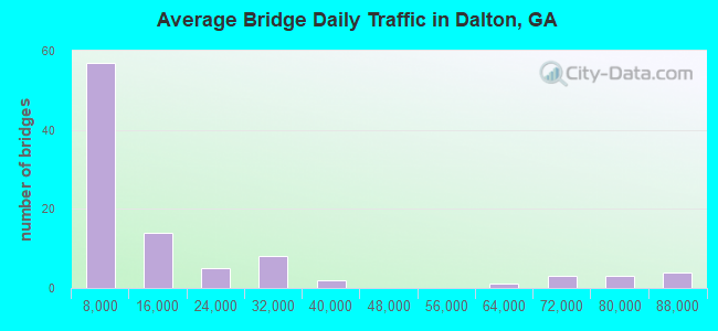
- 1,531,030Total average daily traffic
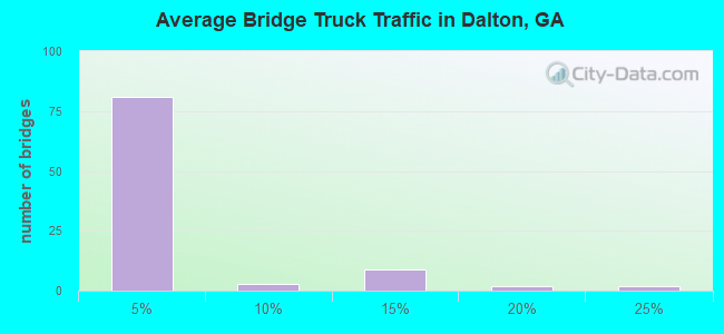
- 46,666Total average daily truck traffic
- National Bridge Inventory (NBI) Registered Bridges for Dalton
- No street view available for this location
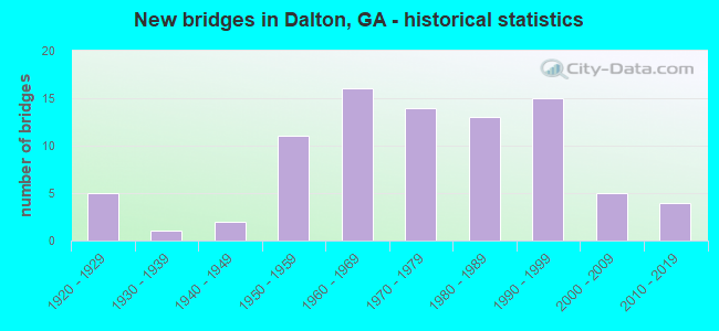
- New bridges - historical statistics
- 51920-1929
- 11930-1939
- 21940-1949
- 111950-1959
- 161960-1969
- 141970-1979
- 131980-1989
- 151990-1999
- 52000-2009
- 42010-2019
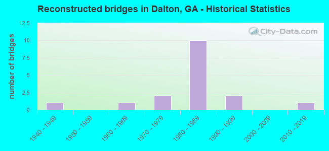
- Reconstructed bridges - Historical Statistics
- 11940-1949
- 01950-1959
- 11960-1969
- 21970-1979
- 101980-1989
- 21990-1999
- 02000-2009
- 12010-2019
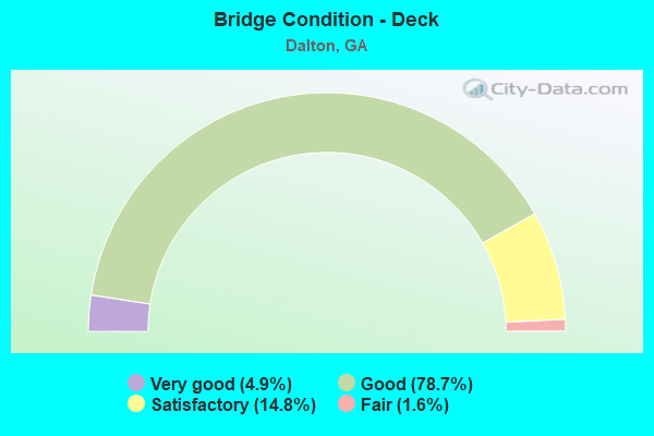
- Bridge Condition - Deck
- 4.9%Very good
- 78.7%Good
- 14.8%Satisfactory
- 1.6%Fair
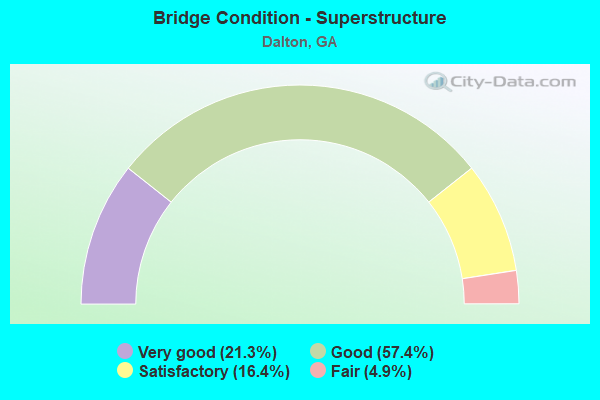
- Bridge Condition - Superstructure
- 21.3%Very good
- 57.4%Good
- 16.4%Satisfactory
- 4.9%Fair
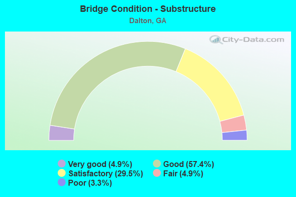
- Bridge Condition - Substructure
- 4.9%Very good
- 57.4%Good
- 29.5%Satisfactory
- 4.9%Fair
- 3.3%Poor
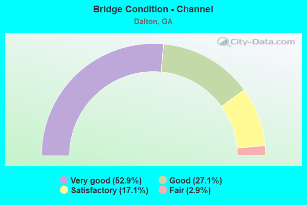
- Bridge Condition - Channel
- 52.9%Very good
- 27.1%Good
- 17.1%Satisfactory
- 2.9%Fair
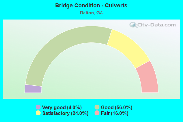
- Bridge Condition - Culverts
- 4.0%Very good
- 56.0%Good
- 24.0%Satisfactory
- 16.0%Fair
Find on map >> Show street view
Structure Number: 3135088, Location: 6.3 MI S OF DALTON (Lat: 34.680547, Lng: -84.940258), Route carried "on" structure: County highway 34, Year Built: 2004, Status: Open, Structure Length: 0.98m (3.22ft), Average Daily Traffic: 600 (year 2011), Truck Traffic: 1%, Average Future Daily Traffic: 900 (year 2031), Design Load: HS 20+Mod, Features Intersected: JOBS CREEK, Facility Carried by Structure: HICKORY ROAD
Minimum Vertical Clearance: 30+ m (98+ ft), Kilometerpoint: 0.000, Lanes on structure: 2, Base Highway Network: Yes, Owner: County Highway Agency, Approaching Roadway Width: 4.9m (16.1ft), Material/Design: Concrete, Design/Construction: Culvert, Number Of Spans In Main Unit: 3, Length of Maximum Span: 3.0m (9.8ft)
Condition: Channel: Good, Culverts: Very good, Operating Rating: 55.3 metric tons, Method Used To Determine Operating Rating: Field evaluation and documented engineering judgment, Inventory Rating: 32.6 metric tons, Method Used To Determine Inventory Rating: Field evaluation and documented engineering judgment, Structural Evaluation: Equal to present desirable criteria, Waterway Adequacy: Somewhat better than minimum adequacy, Approach Roadway Alignment: Equal to present desirable criteria, Designated Inspection Frequency: Every 24 months, Inspection Date: April 2020, Bridge Improvement Cost: $125,000, Roadway Improvement Cost: $13,000, Total Project Cost: $188,000
Find on map >> Show street view
Structure Number: 313509, Location: 3.9 MI W OF DALTON (Lat: 34.788019, Lng: -85.036369), Route carried "on" structure: City street 1519, Year Built: 2005, Status: Open, Structure Length: 0.82m (2.69ft), Average Daily Traffic: 1,270 (year 2011), Truck Traffic: 1%, Average Future Daily Traffic: 1,905 (year 2031), Design Load: H 15, Features Intersected: MILL CREEK TRIB, Facility Carried by Structure: MILL CREEK ROAD
Minimum Vertical Clearance: 30+ m (98+ ft), Kilometerpoint: 14.484, Lanes on structure: 2, Base Highway Network: Yes, Owner: County Highway Agency, Approaching Roadway Width: 6.1m (20.0ft), Skew: 4 degrees, Material/Design: Concrete, Design/Construction: Culvert, Number Of Spans In Main Unit: 3, Length of Maximum Span: 2.4m (7.9ft)
Condition: Channel: Very good, Culverts: Good, Operating Rating: 41.7 metric tons, Method Used To Determine Operating Rating: Field evaluation and documented engineering judgment, Inventory Rating: 24.4 metric tons, Method Used To Determine Inventory Rating: Field evaluation and documented engineering judgment, Structural Evaluation: Equal to present minimum criteria, Waterway Adequacy: Equal to present desirable criteria, Approach Roadway Alignment: Better than present minimum criteria, Designated Inspection Frequency: Every 24 months, Inspection Date: May 2020, Bridge Improvement Cost: $105,000, Roadway Improvement Cost: $11,000, Total Project Cost: $158,000
Find on map >> Show street view
Structure Number: 3135091, Location: 6.1 MI W OF DALTON (Lat: 34.774889, Lng: -85.077978), Route carried "on" structure: County highway 336, Year Built: 2011, Status: Open, Structure Length: 3.66m (12.01ft), Average Daily Traffic: 620 (year 2007), Truck Traffic: 1%, Average Future Daily Traffic: 930 (year 2030), Design Load: HS 20+Mod, Features Intersected: EAST CHICKAMAUGA CREEK, Facility Carried by Structure: DUNNAGAN ROAD
Minimum Vertical Clearance: 30+ m (98+ ft), Kilometerpoint: 9.656, Lanes on structure: 2, Base Highway Network: Yes, Owner: County Highway Agency, Approaching Roadway Width: 6.1m (20.0ft), Material/Design: Prestressed concrete, Design/Construction: Stringer/Multi-beam, Number Of Spans In Main Unit: 3, Length of Maximum Span: 18.3m (60.0ft), Curb-To-Curb Width: 9.7m (31.8ft), Out-to-Out Width: 10.6m (34.8ft)
Condition: Deck: Good, Superstructure: Very good, Substructure: Very good, Channel: Very good, Operating Rating: 66.2 metric tons, Method Used To Determine Operating Rating: Load Factor (LF), Inventory Rating: 22.6 metric tons, Method Used To Determine Inventory Rating: Load Factor (LF), Structural Evaluation: Equal to present minimum criteria, Deck Geometry: Equal to present minimum criteria, Waterway Adequacy: Equal to present desirable criteria, Approach Roadway Alignment: Better than present minimum criteria, Designated Inspection Frequency: Every 24 months, Inspection Date: April 2020, Bridge Improvement Cost: $469,000, Roadway Improvement Cost: $47,000, Total Project Cost: $703,000, Deck Structure Type: Concrete Cast-file-Place
Find on map >> Show street view
Structure Number: 3135094, Location: IN NW DALTON (Lat: 34.793525, Lng: -85.001086), Route carried "on" structure: Interstate 75, Year Built: 2017, Status: Open, Structure Length: 4.33m (14.21ft), Average Daily Traffic: 81,110 (year 2011), Truck Traffic: 1%, Average Future Daily Traffic: 121,665 (year 2031), Design Load: HS 20+Mod, Features Intersected: SR 3 (US 41)
Minimum Vertical Clearance: 30+ m (98+ ft), Kilometerpoint: 540.740, Lanes on structure: 7, Lanes under structure: 7, Base Highway Network: Yes, Owner: State Highway Agency, Approaching Roadway Width: 52.4m (171.9ft), Skew: 31 degrees, Material/Design: Prestressed concrete, Design/Construction: Stringer/Multi-beam, Number Of Spans In Main Unit: 1, Length of Maximum Span: 43.3m (142.1ft), Curb-To-Curb Width: 52.4m (171.9ft), Out-to-Out Width: 55.2m (181.1ft)
Condition: Deck: Good, Superstructure: Good, Substructure: Very good, Operating Rating: 96.1 metric tons, Method Used To Determine Operating Rating: Load Factor (LF), Inventory Rating: 40.8 metric tons, Method Used To Determine Inventory Rating: Load Factor (LF), Structural Evaluation: Better than present minimum criteria, Deck Geometry: Superior to present desirable criteria, Underclear: Equal to present minimum criteria, Approach Roadway Alignment: Equal to present desirable criteria, Length Of Structure Improvement: 5.21m (17.09ft), Designated Inspection Frequency: Every 24 months, Inspection Date: June 2020, Bridge Improvement Cost: $12,654,000, Roadway Improvement Cost: $1,265,000, Total Project Cost: $18,981,000 ( Estimate for 2018), Deck Structure Type: Concrete Cast-file-Place
Find on map >> Show street view
Structure Number: 3135095, Location: 6.5 MI S OF DALTON (Lat: 34.678739, Lng: -84.984889), Route carried "on" structure: US 41, Year Built: 2017, Status: Open, Structure Length: 1.46m (4.79ft), Average Daily Traffic: 7,780 (year 2011), Truck Traffic: 1%, Average Future Daily Traffic: 11,670 (year 2031), Design Load: H 15, Features Intersected: LITTLE SWAMP CREEK
Minimum Vertical Clearance: 30+ m (98+ ft), Kilometerpoint: 8.047, Lanes on structure: 2, Base Highway Network: Yes, Owner: State Highway Agency, Approaching Roadway Width: 9.1m (29.9ft), Skew: 2 degrees, Material/Design: Concrete, Design/Construction: Culvert, Number Of Spans In Main Unit: 4, Length of Maximum Span: 3.0m (9.8ft), Curb-To-Curb Width: 9.1m (29.9ft), Out-to-Out Width: 14.6m (47.9ft)
Condition: Channel: Very good, Culverts: Good, Structural Evaluation: Better than present minimum criteria, Deck Geometry: High priority of corrective action, Waterway Adequacy: Equal to present desirable criteria, Approach Roadway Alignment: Equal to present desirable criteria, Length Of Structure Improvement: 1.58m (5.18ft), Designated Inspection Frequency: Every 24 months, Inspection Date: June 2020, Bridge Improvement Cost: $3,848,000, Roadway Improvement Cost: $385,000, Total Project Cost: $5,772,000 ( Estimate for 2018)
Find on map >> Show street view
Structure Number: 3135096, Location: 8.3 MI S OF DALTON (Lat: 34.653439, Lng: -84.983900), Route carried "on" structure: County highway 691, Year Built: 2018, Status: Open, Structure Length: 6.52m (21.39ft), Average Daily Traffic: 12,530 (year 2015), Truck Traffic: 1%, Average Future Daily Traffic: 14,635 (year 2035), Design Load: HS 20+Mod, Features Intersected: I-75, Facility Carried by Structure: CARBONDALE ROAD
Minimum Vertical Clearance: 30+ m (98+ ft), Kilometerpoint: 4.828, Lanes on structure: 4, Lanes under structure: 6, Base Highway Network: Yes, Owner: State Highway Agency, Approaching Roadway Width: 18.9m (62.0ft), Skew: 10 degrees, Material/Design: Prestressed concrete, Design/Construction: Stringer/Multi-beam, Number Of Spans In Main Unit: 2, Length of Maximum Span: 32.6m (107.0ft), Curb or Sidewalk Widths: Left: 1.7m (5.6ft), Right: 1.7m (5.6ft), Curb-To-Curb Width: 18.9m (62.0ft), Out-to-Out Width: 23.0m (75.5ft)
Condition: Deck: Very good, Superstructure: Good, Substructure: Good, Operating Rating: 88.9 metric tons, Method Used To Determine Operating Rating: Load Factor (LF), Inventory Rating: 49.8 metric tons, Method Used To Determine Inventory Rating: Load Factor (LF), Structural Evaluation: Better than present minimum criteria, Deck Geometry: Equal to present minimum criteria, Underclear: Better than present minimum criteria, Approach Roadway Alignment: Equal to present desirable criteria, Length Of Structure Improvement: 7.83m (25.69ft), Designated Inspection Frequency: Every 24 months, Inspection Date: June 2020, Bridge Improvement Cost: $19,018,000, Roadway Improvement Cost: $1,902,000, Total Project Cost: $28,527,000 ( Estimate for 2018), Deck Structure Type: Concrete Cast-file-Place
Find on map >> Show street view
Structure Number: 3130018, Location: AT SW DALTON CITY LIMIT (Lat: 34.761028, Lng: -85.001908), Route carried "under" structure: Interstate 75, Structure Length: 0. m, Average Daily Traffic: 74,000 (year 1999), Truck Traffic: 12%, Features Intersected: SR 52 WALNUT AVE., Facility Carried by Structure: WALNUT AVE.
Minimum Vertical Clearance: 4.97m (16.31ft), Kilometerpoint: 537.521, Lanes on structure: 5, Length of Maximum Span: 0.0m
Find on map >> Show street view
Structure Number: 3130019, Location: IN SOUTH DALTON (Lat: 34.761536, Lng: -84.966819), Route carried "under" structure: City street 1501, Structure Length: 0. m, Average Daily Traffic: 9,200 (year 2009), Truck Traffic: 1%, Features Intersected: SR - 52, Facility Carried by Structure: SR - 52
Minimum Vertical Clearance: 5.02m (16.47ft), Kilometerpoint: 4.828, Lanes on structure: 5, Length of Maximum Span: 0.0m
Find on map >> Show street view
Structure Number: 3130025, Location: IN NORTH DALTON (Lat: 34.774139, Lng: -84.967408), Route carried "under" structure: City street 1501, Structure Length: 0. m, Average Daily Traffic: 6,500 (year 1999), Truck Traffic: 1%, Features Intersected: M-1510, Facility Carried by Structure: WEST WAUGH STREET
Minimum Vertical Clearance: 6.12m (20.08ft), Kilometerpoint: 6.437, Lanes on structure: 4, Length of Maximum Span: 0.0m
Find on map >> Show street view
Structure Number: 3130047, Location: IN NW DALTON (Lat: 34.798319, Lng: -85.004197), Route carried "under" structure: City street 1506, Structure Length: 0. m, Average Daily Traffic: 2,520 (year 2009), Truck Traffic: 1%, Features Intersected: I-75, Facility Carried by Structure: I-75
Minimum Vertical Clearance: 7.11m (23.33ft), Kilometerpoint: 0.000, Lanes on structure: 7, Length of Maximum Span: 0.0m
Find on map >> Show street view
Structure Number: 3130058, Location: 3 MI SW OF DALTON (Lat: 34.739758, Lng: -85.002319), Route carried "under" structure: Interstate 75, Structure Length: 0. m, Average Daily Traffic: 77,700 (year 1999), Truck Traffic: 1%, Features Intersected: M-1519 DUG GAP ROAD, Facility Carried by Structure: DUG GAP ROAD
Minimum Vertical Clearance: 6.17m (20.24ft), Kilometerpoint: 534.302, Lanes on structure: 2, Length of Maximum Span: 0.0m
Find on map >> Show street view
Structure Number: 3130066, Location: IN WEST DALTON (Lat: 34.782419, Lng: -85.000619), Route carried "under" structure: Interstate 75, Structure Length: 0. m, Average Daily Traffic: 74,000 (year 2009), Truck Traffic: 1%, Features Intersected: M-1515 TIBBS ROAD, Facility Carried by Structure: TIBBS ROAD
Minimum Vertical Clearance: 7.79m (25.56ft), Kilometerpoint: 539.130, Lanes on structure: 2, Length of Maximum Span: 0.0m
Find on map >> Show street view
Structure Number: 3130071, Location: IN NORTH DALTON (BYPASS) (Lat: 34.796900, Lng: -84.965719), Route carried "under" structure: City street 874, Structure Length: 0. m, Average Daily Traffic: 2,280 (year 2009), Truck Traffic: 1%, Features Intersected: SR 3 (US 41), Facility Carried by Structure: US 41, SR 3
Minimum Vertical Clearance: 8.81m (28.90ft), Kilometerpoint: 1.609, Lanes on structure: 5, Length of Maximum Span: 0.0m
Find on map >> Show street view
Structure Number: 3135074, Location: IN N DALTON AT HOSPITAL (Lat: 34.789728, Lng: -84.985878), Route carried "under" structure: City street 1521, Structure Length: 0. m, Average Daily Traffic: 3,142 (year 2011), Truck Traffic: 1%, Features Intersected: M-1521 BROADRICK DRIVE, Facility Carried by Structure: PED BRIDGE
Minimum Vertical Clearance: 4.52m (14.83ft), Kilometerpoint: 1.609, Length of Maximum Span: 0.0m
Find on map >> Show street view
Structure Number: 313508, Location: 6.2 MI SW OF DALTON (Lat: 34.687672, Lng: -85.001950), Route carried "under" structure: Interstate 75, Structure Length: 0. m, Average Daily Traffic: 68,900 (year 1997), Truck Traffic: 12%, Features Intersected: SR 3 CONN., Facility Carried by Structure: SR 3 CONN.
Minimum Vertical Clearance: 5.25m (17.22ft), Kilometerpoint: 529.474, Lanes on structure: 8, Length of Maximum Span: 0.0m
Find on map >> Show street view
Structure Number: 3135094, Location: IN NW DALTON (Lat: 34.793525, Lng: -85.001086), Route carried "under" structure: US 41, Structure Length: 0. m, Average Daily Traffic: 34,800 (year 1999), Truck Traffic: 1%, Features Intersected: I-75, Facility Carried by Structure: I-75
Minimum Vertical Clearance: 5.35m (17.55ft), Kilometerpoint: 33.796, Lanes on structure: 7, Length of Maximum Span: 0.0m
Find on map >> Show street view
Structure Number: 3135096, Location: 8.3 MI S OF DALTON (Lat: 34.653439, Lng: -84.983900), Route carried "under" structure: Interstate 75, Structure Length: 0. m, Average Daily Traffic: 63,500 (year 1999), Truck Traffic: 1%, Features Intersected: S-691 CARBONDALE ROAD, Facility Carried by Structure: CARBONDALE ROAD
Minimum Vertical Clearance: 5.28m (17.32ft), Kilometerpoint: 524.646, Lanes on structure: 4, Length of Maximum Span: 0.0m