Bridge Statistics for DeSoto, Texas (TX)
Condition, Traffic, Stress, Structural Evaluation, Project Costs
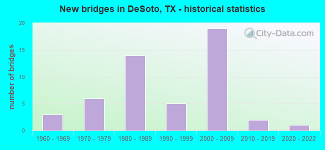
- New bridges - historical statistics
- 31960-1969
- 61970-1979
- 141980-1989
- 51990-1999
- 192000-2009
- 22010-2019
- 12020-2022
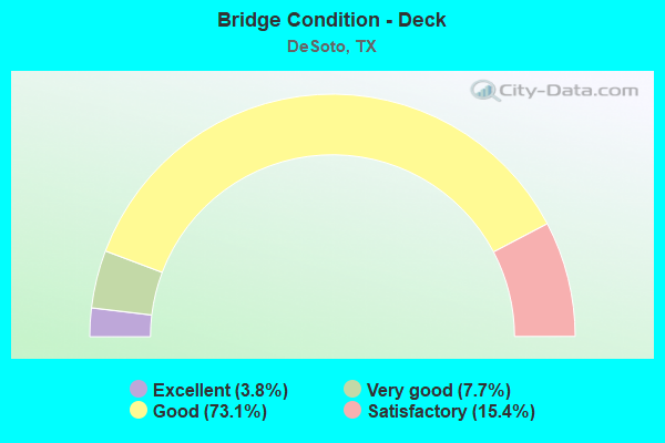
- Bridge Condition - Deck
- 3.8%Excellent
- 7.7%Very good
- 73.1%Good
- 15.4%Satisfactory
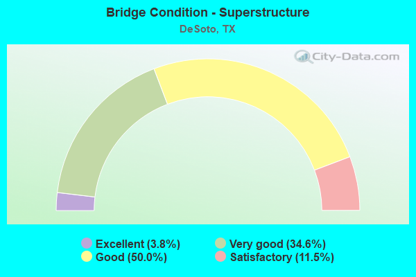
- Bridge Condition - Superstructure
- 3.8%Excellent
- 34.6%Very good
- 50.0%Good
- 11.5%Satisfactory
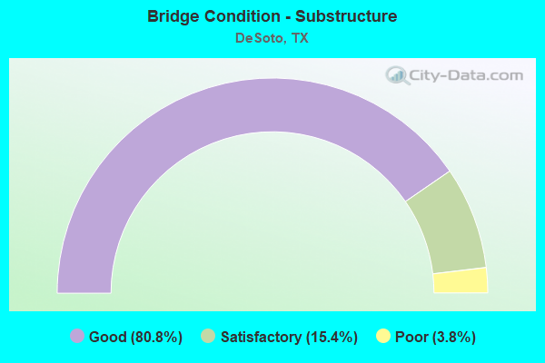
- Bridge Condition - Substructure
- 80.8%Good
- 15.4%Satisfactory
- 3.8%Poor
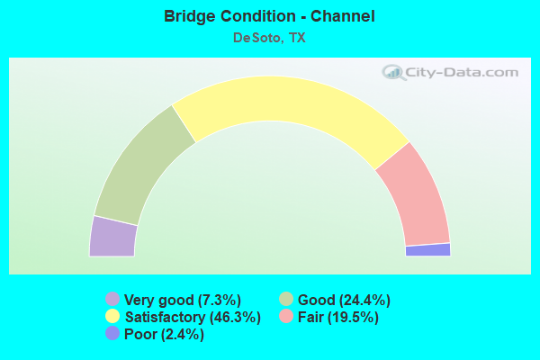
- Bridge Condition - Channel
- 7.3%Very good
- 24.4%Good
- 46.3%Satisfactory
- 19.5%Fair
- 2.4%Poor
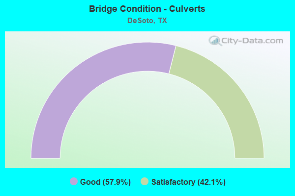
- Bridge Condition - Culverts
- 57.9%Good
- 42.1%Satisfactory
Find on map >> Show street view
Structure Number: 180570044202035, Location: 3.3 MI S OF IH 20 (Lat: 32.594406, Lng: -96.822903), Route carried "on" structure: ServiceInterstate 35, Year Built: 2005, Status: Open, Structure Length: 0.94m (3.08ft), Average Daily Traffic: 20,768 (year 2020), Truck Traffic: 4%, Average Future Daily Traffic: 26,168 (year 2040), Design Load: HS 20, Features Intersected: DRAINAGE DITCH
Minimum Vertical Clearance: 30+ m (98+ ft), Kilometerpoint: 5.462, Lanes on structure: 3, Owner: State Highway Agency, Approaching Roadway Width: 12.2m (40.0ft), Skew: 3 degrees, Material/Design: Concrete, Design/Construction: Culvert, Number Of Spans In Main Unit: 4, Length of Maximum Span: 1.8m (5.9ft), Out-to-Out Width: 12.2m (40.0ft)
Condition: Channel: Satisfactory, Culverts: Good, Operating Rating: 54.4 metric tons, Method Used To Determine Operating Rating: Assigned rating based on Load Factor Design (LFD) reported in metric tons, Inventory Rating: 32.7 metric tons, Method Used To Determine Inventory Rating: Assigned rating based on Load Factor Design (LFD) reported in metric tons, Structural Evaluation: Better than present minimum criteria, Waterway Adequacy: Better than present minimum criteria, Approach Roadway Alignment: Equal to present desirable criteria, Designated Inspection Frequency: Every 24 months, Inspection Date: November 2021
Find on map >> Show street view
Structure Number: 180570044202088, Location: 1.6 Mi S of IH 20 (Lat: 32.619161, Lng: -96.823306), Route carried "on" structure: Interstate 35, Year Built: 2005, Status: Open, Structure Length: 8.99m (29.49ft), Average Daily Traffic: 48,875 (year 2020), Truck Traffic: 16%, Average Future Daily Traffic: 97,749 (year 2040), Design Load: HS 20, Features Intersected: Wintergreen Rd
Minimum Vertical Clearance: 30+ m (98+ ft), Kilometerpoint: 7.929, Lanes on structure: 5, Lanes under structure: 7, Base Highway Network: Yes, Owner: State Highway Agency, Approaching Roadway Width: 24.4m (80.1ft), Material/Design: Prestressed concrete, Design/Construction: Stringer/Multi-beam, Number Of Spans In Main Unit: 1, Number Of Approach Spans: 2, Length of Maximum Span: 37.5m (123.0ft), Curb-To-Curb Width: 24.5m (80.4ft), Out-to-Out Width: 25.3m (83.0ft)
Condition: Deck: Good, Superstructure: Good, Substructure: Good, Operating Rating: 54.4 metric tons, Method Used To Determine Operating Rating: Assigned rating based on Load Factor Design (LFD) reported in metric tons, Inventory Rating: 32.7 metric tons, Method Used To Determine Inventory Rating: Assigned rating based on Load Factor Design (LFD) reported in metric tons, Structural Evaluation: Better than present minimum criteria, Deck Geometry: Equal to present minimum criteria, Underclear: Meets minimum limits, Approach Roadway Alignment: Equal to present desirable criteria, Designated Inspection Frequency: Every 24 months, Inspection Date: November 2021, Deck Structure Type: Concrete Cast-file-Place
Find on map >> Show street view
Structure Number: 180570044202089, Location: 3.6 Mi S of IH 20 (Lat: 32.589747, Lng: -96.822800), Route carried "on" structure: Interstate 35, Year Built: 2005, Status: Open, Structure Length: 8.96m (29.40ft), Average Daily Traffic: 21,165 (year 2020), Truck Traffic: 25%, Average Future Daily Traffic: 35,400 (year 2034), Design Load: HS 20, Features Intersected: Ten Mile Creek, Facility Carried by Structure: Beltline Rd
Minimum Vertical Clearance: 5.51m (18.08ft), Kilometerpoint: 4.828, Lanes on structure: 6, Owner: State Highway Agency, Approaching Roadway Width: 31.7m (104.0ft), Skew: 23 degrees, Material/Design: Prestressed concrete, Design/Construction: Stringer/Multi-beam, Number Of Spans In Main Unit: 2, Number Of Approach Spans: 3, Length of Maximum Span: 24.4m (80.1ft), Curb or Sidewalk Widths: Left: 1.9m (6.2ft), Right: 1.9m (6.2ft), Curb-To-Curb Width: 31.7m (104.0ft), Out-to-Out Width: 37.2m (122.0ft)
Condition: Deck: Good, Superstructure: Very good, Substructure: Good, Channel: Fair, Operating Rating: 54.4 metric tons, Method Used To Determine Operating Rating: Assigned rating based on Load Factor Design (LFD) reported in metric tons, Inventory Rating: 32.7 metric tons, Method Used To Determine Inventory Rating: Assigned rating based on Load Factor Design (LFD) reported in metric tons, Structural Evaluation: Better than present minimum criteria, Deck Geometry: Superior to present desirable criteria, Waterway Adequacy: Superior to present desirable criteria, Approach Roadway Alignment: Equal to present desirable criteria, Designated Inspection Frequency: Every 24 months, Inspection Date: November 2021, Deck Structure Type: Concrete Cast-file-Place
Find on map >> Show street view
Structure Number: 18057004420209, Location: 2.6 Mi S of IH 20 (Lat: 32.604339, Lng: -96.823131), Route carried "on" structure: City street , Year Built: 2005, Status: Open, Structure Length: 5.67m (18.60ft), Average Daily Traffic: 18,302 (year 2019), Truck Traffic: 31%, Average Future Daily Traffic: 25,623 (year 2040), Design Load: HS 20, Features Intersected: IH 35E, Facility Carried by Structure: Pleasant Run Rd WB
Minimum Vertical Clearance: 30+ m (98+ ft), Kilometerpoint: 4.414, Lanes on structure: 5, Lanes under structure: 8, Owner: State Highway Agency, Approaching Roadway Width: 12.2m (40.0ft), Material/Design: Prestressed concrete, Design/Construction: Stringer/Multi-beam, Number Of Spans In Main Unit: 2, Length of Maximum Span: 28.3m (92.8ft), Curb-To-Curb Width: 13.1m (43.0ft), Out-to-Out Width: 23.5m (77.1ft)
Condition: Deck: Good, Superstructure: Very good, Substructure: Good, Operating Rating: 54.4 metric tons, Method Used To Determine Operating Rating: Assigned rating based on Load Factor Design (LFD) reported in metric tons, Inventory Rating: 32.7 metric tons, Method Used To Determine Inventory Rating: Assigned rating based on Load Factor Design (LFD) reported in metric tons, Structural Evaluation: Better than present minimum criteria, Deck Geometry: High priority of replacement, Underclear: Equal to present minimum criteria, Approach Roadway Alignment: Equal to present desirable criteria, Designated Inspection Frequency: Every 24 months, Inspection Date: November 2021, Deck Structure Type: Concrete Cast-file-Place
Find on map >> Show street view
Structure Number: 180570044202091, Location: 2.6 Mi S of IH 20 (Lat: 32.604075, Lng: -96.823100), Route carried "on" structure: City street , Year Built: 2005, Status: Open, Structure Length: 5.67m (18.60ft), Average Daily Traffic: 21,230 (year 2020), Truck Traffic: 3%, Average Future Daily Traffic: 29,722 (year 2040), Design Load: HS 20, Features Intersected: IH 35E, Facility Carried by Structure: Pleasant Run Rd EB
Minimum Vertical Clearance: 30+ m (98+ ft), Kilometerpoint: 4.414, Lanes on structure: 5, Lanes under structure: 8, Owner: State Highway Agency, Approaching Roadway Width: 12.2m (40.0ft), Material/Design: Prestressed concrete, Design/Construction: Stringer/Multi-beam, Number Of Spans In Main Unit: 2, Length of Maximum Span: 28.3m (92.8ft), Curb-To-Curb Width: 13.1m (43.0ft), Out-to-Out Width: 23.5m (77.1ft)
Condition: Deck: Good, Superstructure: Very good, Substructure: Good, Operating Rating: 54.4 metric tons, Method Used To Determine Operating Rating: Assigned rating based on Load Factor Design (LFD) reported in metric tons, Inventory Rating: 32.7 metric tons, Method Used To Determine Inventory Rating: Assigned rating based on Load Factor Design (LFD) reported in metric tons, Structural Evaluation: Better than present minimum criteria, Deck Geometry: High priority of replacement, Underclear: Equal to present minimum criteria, Approach Roadway Alignment: Equal to present desirable criteria, Designated Inspection Frequency: Every 24 months, Inspection Date: November 2021, Deck Structure Type: Concrete Cast-file-Place
Find on map >> Show street view
Structure Number: 180570044202093, Location: 3.6 Mi S of IH 20 (Lat: 32.588964, Lng: -96.822397), Route carried "on" structure: Interstate 35, Year Built: 2005, Status: Open, Structure Length: 20.67m (67.81ft), Average Daily Traffic: 47,177 (year 2020), Truck Traffic: 16%, Average Future Daily Traffic: 94,354 (year 2040), Design Load: HS 20, Features Intersected: Ten Mile Ck & BeltlineRd
Minimum Vertical Clearance: 30+ m (98+ ft), Kilometerpoint: 4.828, Lanes on structure: 4, Lanes under structure: 8, Base Highway Network: Yes, Owner: State Highway Agency, Approaching Roadway Width: 20.7m (67.9ft), Skew: 9 degrees, Material/Design: Prestressed concrete, Design/Construction: Stringer/Multi-beam, Number Of Spans In Main Unit: 4, Number Of Approach Spans: 2, Length of Maximum Span: 40.2m (131.9ft), Curb-To-Curb Width: 20.8m (68.2ft), Out-to-Out Width: 21.6m (70.9ft)
Condition: Deck: Good, Superstructure: Good, Substructure: Satisfactory, Channel: Fair, Operating Rating: 54.4 metric tons, Method Used To Determine Operating Rating: Assigned rating based on Load Factor Design (LFD) reported in metric tons, Inventory Rating: 32.7 metric tons, Method Used To Determine Inventory Rating: Assigned rating based on Load Factor Design (LFD) reported in metric tons, Structural Evaluation: Equal to present minimum criteria, Deck Geometry: Equal to present minimum criteria, Underclear: Superior to present desirable criteria, Waterway Adequacy: Superior to present desirable criteria, Approach Roadway Alignment: Equal to present desirable criteria, Designated Inspection Frequency: Every 24 months, Inspection Date: November 2021, Deck Structure Type: Concrete Cast-file-Place
Find on map >> Show street view
Structure Number: 180570044202095, Location: 3.6 Mi S of IH 20 (Lat: 32.589631, Lng: -96.822775), Route carried "on" structure: ServiceInterstate 35, Year Built: 2005, Status: Open, Structure Length: 5.76m (18.90ft), Average Daily Traffic: 20,768 (year 2020), Truck Traffic: 4%, Average Future Daily Traffic: 26,168 (year 2040), Design Load: HS 20, Features Intersected: Ten Mile Creek
Minimum Vertical Clearance: 30+ m (98+ ft), Kilometerpoint: 4.828, Lanes on structure: 4, Owner: State Highway Agency, Approaching Roadway Width: 12.2m (40.0ft), Skew: 4 degrees, Material/Design: Prestressed concrete, Design/Construction: Stringer/Multi-beam, Number Of Spans In Main Unit: 2, Length of Maximum Span: 29.0m (95.1ft), Curb or Sidewalk Widths: Left: 1.9m (6.2ft), Right: 1.9m (6.2ft), Curb-To-Curb Width: 15.9m (52.2ft), Out-to-Out Width: 20.1m (65.9ft)
Condition: Deck: Good, Superstructure: Good, Substructure: Good, Channel: Satisfactory, Operating Rating: 54.4 metric tons, Method Used To Determine Operating Rating: Assigned rating based on Load Factor Design (LFD) reported in metric tons, Inventory Rating: 32.7 metric tons, Method Used To Determine Inventory Rating: Assigned rating based on Load Factor Design (LFD) reported in metric tons, Structural Evaluation: Better than present minimum criteria, Deck Geometry: High priority of replacement, Waterway Adequacy: Superior to present desirable criteria, Approach Roadway Alignment: Equal to present desirable criteria, Designated Inspection Frequency: Every 24 months, Inspection Date: November 2021, Deck Structure Type: Concrete Cast-file-Place
Find on map >> Show street view
Structure Number: 180570044202348, Location: 4.6 Mi S of IH 20 (Lat: 32.575039, Lng: -96.822583), Route carried "on" structure: Interstate 35, Year Built: 2008, Status: Open, Structure Length: 9.45m (31.00ft), Average Daily Traffic: 47,177 (year 2020), Truck Traffic: 16%, Average Future Daily Traffic: 94,354 (year 2040), Design Load: HS 25 or greater, Features Intersected: Parkerville Rd
Minimum Vertical Clearance: 30+ m (98+ ft), Kilometerpoint: 3.288, Lanes on structure: 3, Lanes under structure: 2, Base Highway Network: Yes, Owner: State Highway Agency, Approaching Roadway Width: 17.7m (58.1ft), Material/Design: Prestressed concrete, Design/Construction: Stringer/Multi-beam, Number Of Spans In Main Unit: 3, Length of Maximum Span: 36.0m (118.1ft), Curb-To-Curb Width: 20.8m (68.2ft), Out-to-Out Width: 21.6m (70.9ft)
Condition: Deck: Good, Superstructure: Good, Substructure: Good, Operating Rating: 68.0 metric tons, Method Used To Determine Operating Rating: Assigned rating based on Load Factor Design (LFD) reported in metric tons, Inventory Rating: 40.8 metric tons, Method Used To Determine Inventory Rating: Assigned rating based on Load Factor Design (LFD) reported in metric tons, Structural Evaluation: Better than present minimum criteria, Deck Geometry: Superior to present desirable criteria, Underclear: Superior to present desirable criteria, Approach Roadway Alignment: Equal to present desirable criteria, Designated Inspection Frequency: Every 24 months, Inspection Date: November 2021, Deck Structure Type: Concrete Cast-file-Place
Find on map >> Show street view
Structure Number: 180570104702027, Location: 0.1 Mi W of IH 35E (Lat: 32.589850, Lng: -96.823444), Route carried "on" structure: State highway 1382, Year Built: 1981, Status: Open, Structure Length: 0.79m (2.59ft), Average Daily Traffic: 21,165 (year 2020), Average Future Daily Traffic: 28,660 (year 2033), Design Load: HS 20, Features Intersected: Draw
Minimum Vertical Clearance: 30+ m (98+ ft), Kilometerpoint: 35.320, Lanes on structure: 4, Owner: State Highway Agency, Approaching Roadway Width: 14.6m (47.9ft), Skew: 29 degrees, Material/Design: Concrete, Design/Construction: Culvert, Number Of Spans In Main Unit: 2, Length of Maximum Span: 2.7m (8.9ft), Curb or Sidewalk Widths: Left: 1.8m (5.9ft), Right: 2.0m (6.6ft)
Condition: Channel: Good, Culverts: Satisfactory, Operating Rating: 39.9 metric tons, Method Used To Determine Operating Rating: Load Factor (LF), Inventory Rating: 23.6 metric tons, Method Used To Determine Inventory Rating: Load Factor (LF), Structural Evaluation: Somewhat better than minimum adequacy, Waterway Adequacy: Equal to present minimum criteria, Approach Roadway Alignment: Equal to present desirable criteria, Designated Inspection Frequency: Every 24 months, Inspection Date: December 2021
Find on map >> Show street view
Structure Number: 180570104702031, Location: 3.80 MI E OF US 67 (Lat: 32.589692, Lng: -96.877808), Route carried "on" structure: State highway 1382, Year Built: 2005, Status: Open, Structure Length: 2.71m (8.89ft), Average Daily Traffic: 21,956 (year 2019), Truck Traffic: 2%, Average Future Daily Traffic: 26,340 (year 2033), Design Load: HS 20, Features Intersected: Heath Creek
Minimum Vertical Clearance: 30+ m (98+ ft), Kilometerpoint: 24.971, Lanes on structure: 6, Owner: State Highway Agency, Approaching Roadway Width: 19.2m (63.0ft), Skew: 20 degrees, Material/Design: Prestressed concrete, Design/Construction: Stringer/Multi-beam, Number Of Spans In Main Unit: 1, Length of Maximum Span: 26.5m (86.9ft), Curb or Sidewalk Widths: Left: 1.8m (5.9ft), Right: 1.8m (5.9ft), Curb-To-Curb Width: 23.7m (77.8ft), Out-to-Out Width: 33.6m (110.2ft)
Condition: Deck: Good, Superstructure: Very good, Substructure: Good, Channel: Good, Operating Rating: 54.4 metric tons, Method Used To Determine Operating Rating: Assigned rating based on Load Factor Design (LFD) reported in metric tons, Inventory Rating: 32.7 metric tons, Method Used To Determine Inventory Rating: Assigned rating based on Load Factor Design (LFD) reported in metric tons, Structural Evaluation: Better than present minimum criteria, Deck Geometry: Somewhat better than minimum adequacy, Waterway Adequacy: Superior to present desirable criteria, Approach Roadway Alignment: Equal to present desirable criteria, Designated Inspection Frequency: Every 24 months, Inspection Date: December 2021, Deck Structure Type: Concrete Precast Panels
Find on map >> Show street view
Structure Number: 180570104702032, Location: 4.70 MI E OF US 67 (Lat: 32.589619, Lng: -96.862236), Route carried "on" structure: State highway 1382, Year Built: 2005, Status: Open, Structure Length: 3.69m (12.11ft), Average Daily Traffic: 16,004 (year 2020), Truck Traffic: 2%, Average Future Daily Traffic: 26,340 (year 2033), Design Load: HS 20, Features Intersected: Heath Creek Branch
Minimum Vertical Clearance: 30+ m (98+ ft), Kilometerpoint: 26.432, Lanes on structure: 5, Owner: State Highway Agency, Approaching Roadway Width: 24.4m (80.1ft), Skew: 20 degrees, Material/Design: Prestressed concrete, Design/Construction: Stringer/Multi-beam, Number Of Spans In Main Unit: 2, Length of Maximum Span: 20.1m (65.9ft), Curb or Sidewalk Widths: Left: 1.8m (5.9ft), Right: 1.8m (5.9ft), Curb-To-Curb Width: 24.1m (79.1ft), Out-to-Out Width: 33.6m (110.2ft)
Condition: Deck: Good, Superstructure: Very good, Substructure: Good, Channel: Good, Operating Rating: 54.4 metric tons, Method Used To Determine Operating Rating: Assigned rating based on Load Factor Design (LFD) reported in metric tons, Inventory Rating: 32.7 metric tons, Method Used To Determine Inventory Rating: Assigned rating based on Load Factor Design (LFD) reported in metric tons, Structural Evaluation: Better than present minimum criteria, Deck Geometry: Superior to present desirable criteria, Waterway Adequacy: Superior to present desirable criteria, Approach Roadway Alignment: Equal to present desirable criteria, Designated Inspection Frequency: Every 24 months, Inspection Date: December 2021, Deck Structure Type: Concrete Precast Panels
Find on map >> Show street view
Structure Number: 180570J00145001, Location: 0.3 MI W of N Polk St (Lat: 32.624242, Lng: -96.844875), Route carried "on" structure: City street , Year Built: 1998, Status: Open, Structure Length: 1.31m (4.30ft), Average Daily Traffic: 2,194 (year 2019), Truck Traffic: 3%, Average Future Daily Traffic: 3,072 (year 2039), Features Intersected: TRIB TENMILE CREEK, Facility Carried by Structure: E CENTRE PARK BLVD
Minimum Vertical Clearance: 30+ m (98+ ft), Kilometerpoint: 0.483, Lanes on structure: 5, Owner: City or Municipal Highway Agency, Approaching Roadway Width: 18.3m (60.0ft), Material/Design: Concrete, Design/Construction: Culvert, Number Of Spans In Main Unit: 4, Length of Maximum Span: 3.0m (9.8ft), Curb or Sidewalk Widths: Left: 1.5m (4.9ft), Right: 1.5m (4.9ft), Curb-To-Curb Width: 18.3m (60.0ft), Out-to-Out Width: 34.5m (113.2ft)
Condition: Channel: Good, Culverts: Good, Operating Rating: 32.7 metric tons, Method Used To Determine Operating Rating: Field evaluation and documented engineering judgment, Inventory Rating: 24.5 metric tons, Method Used To Determine Inventory Rating: Field evaluation and documented engineering judgment, Structural Evaluation: Equal to present minimum criteria, Deck Geometry: High priority of replacement, Waterway Adequacy: Superior to present desirable criteria, Approach Roadway Alignment: Equal to present desirable criteria, Designated Inspection Frequency: Every 24 months, Inspection Date: Febuary 2021, Deck Structure Type: Concrete Cast-file-Place, Wearing Surface/Protective System: Wearing Surface: Monolithic Concrete
Find on map >> Show street view
Structure Number: 180570J00175001, Location: 0.3 MI S OF PLEASANT RN (Lat: 32.600172, Lng: -96.850725), Route carried "on" structure: City street , Year Built: 1997, Status: Open, Structure Length: 2.77m (9.09ft), Average Daily Traffic: 3,480 (year 2011), Average Future Daily Traffic: 4,700 (year 2031), Features Intersected: HEATH CREEK, Facility Carried by Structure: CHATTEY RD
Minimum Vertical Clearance: 30+ m (98+ ft), Kilometerpoint: 0.483, Lanes on structure: 2, Owner: City or Municipal Highway Agency, Approaching Roadway Width: 11.0m (36.1ft), Material/Design: Concrete, Design/Construction: Stringer/Multi-beam, Number Of Spans In Main Unit: 3, Length of Maximum Span: 9.1m (29.9ft), Curb or Sidewalk Widths: Left: 1.9m (6.2ft), Right: 1.9m (6.2ft), Curb-To-Curb Width: 11.1m (36.4ft), Out-to-Out Width: 15.3m (50.2ft)
Condition: Deck: Good, Superstructure: Good, Substructure: Good, Channel: Satisfactory, Operating Rating: 32.7 metric tons, Method Used To Determine Operating Rating: Field evaluation and documented engineering judgment, Inventory Rating: 24.5 metric tons, Method Used To Determine Inventory Rating: Field evaluation and documented engineering judgment, Structural Evaluation: Equal to present minimum criteria, Deck Geometry: Somewhat better than minimum adequacy, Waterway Adequacy: Better than present minimum criteria, Approach Roadway Alignment: Equal to present desirable criteria, Designated Inspection Frequency: Every 24 months, Inspection Date: March 2021, Deck Structure Type: Concrete Cast-file-Place
Find on map >> Show street view
Structure Number: 180570J00220006, Location: 0.4 MI N OF PLEASANT RUN (Lat: 32.609867, Lng: -96.891250), Route carried "on" structure: City street , Year Built: 2009, Status: Open, Structure Length: 4.57m (14.99ft), Average Daily Traffic: 1,500 (year 2011), Average Future Daily Traffic: 2,500 (year 2031), Design Load: HS 20, Features Intersected: BEE BRANCH, Facility Carried by Structure: COCKRELL HILL SB
Minimum Vertical Clearance: 30+ m (98+ ft), Kilometerpoint: 16.367, Lanes on structure: 2, Owner: City or Municipal Highway Agency, Approaching Roadway Width: 7.3m (24.0ft), Skew: 4 degrees, Material/Design: Prestressed concrete, Design/Construction: Stringer/Multi-beam, Number Of Spans In Main Unit: 3, Length of Maximum Span: 15.2m (49.9ft), Curb or Sidewalk Widths: Left: 0.6m (2.0ft), Right: 1.7m (5.6ft), Curb-To-Curb Width: 10.1m (33.1ft), Out-to-Out Width: 13.0m (42.7ft)
Condition: Deck: Good, Superstructure: Very good, Substructure: Good, Channel: Satisfactory, Operating Rating: 54.4 metric tons, Method Used To Determine Operating Rating: Assigned rating based on Load Factor Design (LFD) reported in metric tons, Inventory Rating: 32.7 metric tons, Method Used To Determine Inventory Rating: Assigned rating based on Load Factor Design (LFD) reported in metric tons, Structural Evaluation: Better than present minimum criteria, Deck Geometry: Somewhat better than minimum adequacy, Waterway Adequacy: Superior to present desirable criteria, Approach Roadway Alignment: Equal to present desirable criteria, Designated Inspection Frequency: Every 24 months, Inspection Date: May 2021, Deck Structure Type: Concrete Cast-file-Place, Wearing Surface/Protective System: Deck Protection: Epoxy Coated Reinforcing
Find on map >> Show street view
Structure Number: 180570J00220007, Location: 0.4 MI N OF PLEASANT RUN (Lat: 32.609847, Lng: -96.891264), Route carried "on" structure: City street , Year Built: 2009, Status: Open, Structure Length: 4.57m (14.99ft), Average Daily Traffic: 1,500 (year 2011), Average Future Daily Traffic: 2,500 (year 2031), Design Load: HS 20, Features Intersected: BEE BRANCH, Facility Carried by Structure: COCKRELL HILL NB
Minimum Vertical Clearance: 30+ m (98+ ft), Kilometerpoint: 16.367, Lanes on structure: 2, Owner: City or Municipal Highway Agency, Approaching Roadway Width: 7.3m (24.0ft), Skew: 4 degrees, Material/Design: Prestressed concrete, Design/Construction: Stringer/Multi-beam, Number Of Spans In Main Unit: 3, Length of Maximum Span: 15.2m (49.9ft), Curb or Sidewalk Widths: Left: 0.6m (2.0ft), Right: 1.7m (5.6ft), Curb-To-Curb Width: 10.1m (33.1ft), Out-to-Out Width: 13.0m (42.7ft)
Condition: Deck: Good, Superstructure: Very good, Substructure: Good, Channel: Satisfactory, Operating Rating: 54.4 metric tons, Method Used To Determine Operating Rating: Assigned rating based on Load Factor Design (LFD) reported in metric tons, Inventory Rating: 32.7 metric tons, Method Used To Determine Inventory Rating: Assigned rating based on Load Factor Design (LFD) reported in metric tons, Structural Evaluation: Better than present minimum criteria, Deck Geometry: Somewhat better than minimum adequacy, Waterway Adequacy: Superior to present desirable criteria, Approach Roadway Alignment: Equal to present desirable criteria, Designated Inspection Frequency: Every 24 months, Inspection Date: May 2021, Deck Structure Type: Concrete Cast-file-Place
Find on map >> Show street view
Structure Number: 180570J00315001, Location: 0.3 MI W of N Hampton Rd (Lat: 32.582572, Lng: -96.862992), Route carried "on" structure: City street , Year Built: 1995, Status: Open, Structure Length: 0.67m (2.20ft), Average Daily Traffic: 3,787 (year 2019), Truck Traffic: 3%, Average Future Daily Traffic: 5,302 (year 2039), Design Load: HS 20, Features Intersected: TRIB HEATH CREEK, Facility Carried by Structure: EAGLE DR
Minimum Vertical Clearance: 30+ m (98+ ft), Kilometerpoint: 0.483, Lanes on structure: 4, Owner: City or Municipal Highway Agency, Approaching Roadway Width: 14.0m (45.9ft), Skew: 21 degrees, Material/Design: Steel, Design/Construction: Culvert, Number Of Spans In Main Unit: 3, Length of Maximum Span: 1.8m (5.9ft), Curb or Sidewalk Widths: Left: 2.1m (6.9ft), Right: 1.5m (4.9ft), Curb-To-Curb Width: 14.0m (45.9ft), Out-to-Out Width: 32.8m (107.6ft)
Condition: Channel: Very good, Culverts: Good, Operating Rating: 39.9 metric tons, Method Used To Determine Operating Rating: Load Factor (LF), Inventory Rating: 23.6 metric tons, Method Used To Determine Inventory Rating: Load Factor (LF), Structural Evaluation: Equal to present minimum criteria, Deck Geometry: High priority of replacement, Waterway Adequacy: Better than present minimum criteria, Approach Roadway Alignment: Equal to present desirable criteria, Designated Inspection Frequency: Every 24 months, Inspection Date: Febuary 2021, Deck Structure Type: Corrugated Steel, Wearing Surface/Protective System: Wearing Surface: Bituminous
Find on map >> Show street view
Structure Number: 180570J00475006, Location: 0.1 MI N OF PLEASANT RN (Lat: 32.606447, Lng: -96.857117), Route carried "on" structure: City street , Year Built: 1971, Year Reconstructed: 1986, Status: Open, Structure Length: 7.32m (24.02ft), Average Daily Traffic: 16,771 (year 2019), Average Future Daily Traffic: 28,000 (year 2031), Features Intersected: TEN MILE CREEK, Facility Carried by Structure: HAMPTON RD
Minimum Vertical Clearance: 30+ m (98+ ft), Kilometerpoint: 23.818, Lanes on structure: 6, Owner: City or Municipal Highway Agency, Approaching Roadway Width: 20.1m (65.9ft), Skew: 23 degrees, Material/Design: Concrete continuous, Design/Construction: Slab, Number Of Spans In Main Unit: 6, Length of Maximum Span: 12.8m (42.0ft), Curb or Sidewalk Widths: Left: 1.7m (5.6ft), Right: 1.7m (5.6ft), Curb-To-Curb Width: 20.1m (65.9ft), Out-to-Out Width: 28.3m (92.8ft)
Condition: Deck: Satisfactory, Superstructure: Satisfactory, Substructure: Satisfactory, Channel: Fair, Operating Rating: 32.7 metric tons, Method Used To Determine Operating Rating: Field evaluation and documented engineering judgment, Inventory Rating: 24.5 metric tons, Method Used To Determine Inventory Rating: Field evaluation and documented engineering judgment, Structural Evaluation: Equal to present minimum criteria, Deck Geometry: High priority of replacement, Waterway Adequacy: Equal to present minimum criteria, Approach Roadway Alignment: Equal to present desirable criteria, Length Of Structure Improvement: 7.32m (24.02ft), Designated Inspection Frequency: Every 24 months, Inspection Date: March 2021, Bridge Improvement Cost: $32,000, Roadway Improvement Cost: $8,000, Total Project Cost: $40,000, Deck Structure Type: Concrete Cast-file-Place
Find on map >> Show street view
Structure Number: 180570J00475007, Location: 0.4 MI S OF PLEASANT RN (Lat: 32.597831, Lng: -96.857219), Route carried "on" structure: City street , Year Built: 1971, Year Reconstructed: 1980, Status: Open, Structure Length: 2.65m (8.69ft), Average Daily Traffic: 20,850 (year 2011), Average Future Daily Traffic: 28,000 (year 2031), Features Intersected: HEATH CREEK, Facility Carried by Structure: HAMPTON RD
Minimum Vertical Clearance: 30+ m (98+ ft), Kilometerpoint: 24.784, Lanes on structure: 4, Owner: City or Municipal Highway Agency, Approaching Roadway Width: 14.6m (47.9ft), Skew: 20 degrees, Material/Design: Prestressed concrete, Design/Construction: Stringer/Multi-beam, Number Of Spans In Main Unit: 2, Length of Maximum Span: 13.1m (43.0ft), Curb or Sidewalk Widths: Left: 1.7m (5.6ft), Right: 1.7m (5.6ft), Curb-To-Curb Width: 14.5m (47.6ft), Out-to-Out Width: 22.9m (75.1ft)
Condition: Deck: Satisfactory, Superstructure: Good, Substructure: Good, Channel: Fair, Operating Rating: 32.7 metric tons, Method Used To Determine Operating Rating: Field evaluation and documented engineering judgment, Inventory Rating: 24.5 metric tons, Method Used To Determine Inventory Rating: Field evaluation and documented engineering judgment, Structural Evaluation: Equal to present minimum criteria, Deck Geometry: High priority of replacement, Waterway Adequacy: Equal to present minimum criteria, Approach Roadway Alignment: Equal to present desirable criteria, Length Of Structure Improvement: 2.65m (8.69ft), Designated Inspection Frequency: Every 24 months, Inspection Date: March 2021, Bridge Improvement Cost: $8,000, Roadway Improvement Cost: $2,000, Total Project Cost: $10,000, Deck Structure Type: Concrete Cast-file-Place
Find on map >> Show street view
Structure Number: 180570J00480001, Location: 0.3 MI E OF HAMPTON RD (Lat: 32.612106, Lng: -96.852083), Route carried "on" structure: City street , Year Built: 1975, Status: Open, Structure Length: 0.82m (2.69ft), Average Daily Traffic: 1,715 (year 2019), Average Future Daily Traffic: 2,500 (year 2031), Features Intersected: TEN MILE CREEK TRIB, Facility Carried by Structure: HANNA AVE
Minimum Vertical Clearance: 30+ m (98+ ft), Kilometerpoint: 0.483, Lanes on structure: 2, Owner: City or Municipal Highway Agency, Approaching Roadway Width: 11.0m (36.1ft), Skew: 3 degrees, Material/Design: Concrete, Design/Construction: Culvert, Number Of Spans In Main Unit: 4, Length of Maximum Span: 1.5m (4.9ft), Curb or Sidewalk Widths: Left: 1.2m (3.9ft), Right: 1.2m (3.9ft)
Condition: Channel: Satisfactory, Culverts: Satisfactory, Operating Rating: 32.7 metric tons, Method Used To Determine Operating Rating: Field evaluation and documented engineering judgment, Inventory Rating: 24.5 metric tons, Method Used To Determine Inventory Rating: Field evaluation and documented engineering judgment, Structural Evaluation: Equal to present minimum criteria, Waterway Adequacy: Better than present minimum criteria, Approach Roadway Alignment: Equal to present desirable criteria, Designated Inspection Frequency: Every 24 months, Inspection Date: March 2021
Find on map >> Show street view
Structure Number: 180570J00785001, Location: 0.10 MI W OF IH 35E (Lat: 32.613167, Lng: -96.824981), Route carried "on" structure: City street , Year Built: 1974, Status: Open, Structure Length: 0.67m (2.20ft), Average Daily Traffic: 330 (year 2011), Average Future Daily Traffic: 780 (year 2031), Features Intersected: TEN MILE CREEK TRIBUTARY, Facility Carried by Structure: MEADOWS PKWY
Minimum Vertical Clearance: 30+ m (98+ ft), Kilometerpoint: 0.161, Lanes on structure: 2, Owner: City or Municipal Highway Agency, Approaching Roadway Width: 11.0m (36.1ft), Material/Design: Concrete, Design/Construction: Culvert, Number Of Spans In Main Unit: 2, Length of Maximum Span: 3.0m (9.8ft)
Condition: Channel: Satisfactory, Culverts: Satisfactory, Operating Rating: 32.7 metric tons, Method Used To Determine Operating Rating: Field evaluation and documented engineering judgment, Inventory Rating: 24.5 metric tons, Method Used To Determine Inventory Rating: Field evaluation and documented engineering judgment, Structural Evaluation: Equal to present minimum criteria, Waterway Adequacy: Better than present minimum criteria, Approach Roadway Alignment: Equal to present desirable criteria, Designated Inspection Frequency: Every 24 months, Inspection Date: April 2021
Find on map >> Show street view
Structure Number: 180570J00785002, Location: 0.55 MI N OF PLEASANT RUN (Lat: 32.611958, Lng: -96.830333), Route carried "on" structure: City street , Year Built: 1974, Status: Open, Structure Length: 0.79m (2.59ft), Average Daily Traffic: 1,550 (year 2011), Average Future Daily Traffic: 3,070 (year 2031), Features Intersected: TEN MILE CREEK TRIBUTARY, Facility Carried by Structure: MEADOWS PKWY
Minimum Vertical Clearance: 30+ m (98+ ft), Kilometerpoint: 0.805, Lanes on structure: 2, Owner: City or Municipal Highway Agency, Approaching Roadway Width: 11.0m (36.1ft), Material/Design: Concrete, Design/Construction: Culvert, Number Of Spans In Main Unit: 3, Length of Maximum Span: 2.4m (7.9ft), Curb or Sidewalk Widths: Left: 1.2m (3.9ft), Right: 1.5m (4.9ft)
Condition: Channel: Fair, Culverts: Satisfactory, Operating Rating: 32.7 metric tons, Method Used To Determine Operating Rating: Field evaluation and documented engineering judgment, Inventory Rating: 24.5 metric tons, Method Used To Determine Inventory Rating: Field evaluation and documented engineering judgment, Structural Evaluation: Equal to present minimum criteria, Waterway Adequacy: Better than present minimum criteria, Approach Roadway Alignment: Equal to present desirable criteria, Designated Inspection Frequency: Every 24 months, Inspection Date: April 2021
Find on map >> Show street view
Structure Number: 180570J00785003, Location: 0.4 MI S OF PLEASANT RN (Lat: 32.599481, Lng: -96.833828), Route carried "on" structure: City street , Year Built: 1974, Status: Open, Structure Length: 5.55m (18.21ft), Average Daily Traffic: 2,900 (year 2011), Average Future Daily Traffic: 4,000 (year 2031), Features Intersected: TEN MILE CREEK, Facility Carried by Structure: MEADOWS PKWY
Minimum Vertical Clearance: 30+ m (98+ ft), Kilometerpoint: 2.253, Lanes on structure: 2, Owner: City or Municipal Highway Agency, Approaching Roadway Width: 11.0m (36.1ft), Material/Design: Concrete, Design/Construction: Stringer/Multi-beam, Number Of Spans In Main Unit: 3, Number Of Approach Spans: 2, Length of Maximum Span: 12.2m (40.0ft), Curb or Sidewalk Widths: Left: 0.3m (1.0ft), Right: 1.5m (4.9ft), Curb-To-Curb Width: 11.0m (36.1ft), Out-to-Out Width: 13.4m (44.0ft)
Condition: Deck: Good, Superstructure: Good, Substructure: Good, Channel: Satisfactory, Operating Rating: 32.7 metric tons, Method Used To Determine Operating Rating: Field evaluation and documented engineering judgment, Inventory Rating: 24.5 metric tons, Method Used To Determine Inventory Rating: Field evaluation and documented engineering judgment, Structural Evaluation: Equal to present minimum criteria, Deck Geometry: Somewhat better than minimum adequacy, Waterway Adequacy: Better than present minimum criteria, Approach Roadway Alignment: Equal to present desirable criteria, Length Of Structure Improvement: 5.55m (18.21ft), Designated Inspection Frequency: Every 24 months, Inspection Date: April 2021, Bridge Improvement Cost: $13,000, Roadway Improvement Cost: $3,000, Total Project Cost: $16,000, Deck Structure Type: Concrete Cast-file-Place
Find on map >> Show street view
Structure Number: 180570J00935005, Location: 0.2 MI W OF POLK ST (Lat: 32.604289, Lng: -96.843350), Route carried "on" structure: City street , Year Built: 1966, Year Reconstructed: 1986, Status: Posted for load, Structure Length: 6.10m (20.01ft), Average Daily Traffic: 6,000 (year 2011), Average Future Daily Traffic: 9,500 (year 2031), Features Intersected: TEN MILE CREEK, Facility Carried by Structure: PLEASANT RUN RD
Minimum Vertical Clearance: 30+ m (98+ ft), Kilometerpoint: 11.909, Lanes on structure: 5, Owner: City or Municipal Highway Agency, Approaching Roadway Width: 20.1m (65.9ft), Skew: 20 degrees, Material/Design: Concrete, Design/Construction: Stringer/Multi-beam, Number Of Spans In Main Unit: 5, Length of Maximum Span: 12.2m (40.0ft), Curb or Sidewalk Widths: Left: 1.5m (4.9ft), Right: 1.5m (4.9ft), Curb-To-Curb Width: 20.3m (66.6ft), Out-to-Out Width: 28.1m (92.2ft)
Condition: Deck: Satisfactory, Superstructure: Satisfactory, Substructure: Poor, Channel: Satisfactory, Operating Rating: 32.7 metric tons, Method Used To Determine Operating Rating: Field evaluation and documented engineering judgment, Inventory Rating: 24.5 metric tons, Method Used To Determine Inventory Rating: Field evaluation and documented engineering judgment, Structural Evaluation: Meets minimum limits, Deck Geometry: Somewhat better than minimum adequacy, Waterway Adequacy: Superior to present desirable criteria, Approach Roadway Alignment: Equal to present desirable criteria, Bridge Posting: Required (Relationship of Operating Rating to Maximum Legal Load: 10.0 - 19.9% below), Designated Inspection Frequency: Every 24 months, Inspection Date: March 2021, Deck Structure Type: Concrete Cast-file-Place, Wearing Surface/Protective System: Wearing Surface: Bituminous
Find on map >> Show street view
Structure Number: 180570J00935006, Location: 0.2 MI E OF POLK ST (Lat: 32.604175, Lng: -96.838364), Route carried "on" structure: City street , Year Built: 1986, Status: Open, Structure Length: 1.92m (6.30ft), Average Daily Traffic: 6,000 (year 2011), Average Future Daily Traffic: 9,500 (year 2031), Features Intersected: TEN MILE CRK TRIB, Facility Carried by Structure: PLEASANT RUN RD
Minimum Vertical Clearance: 30+ m (98+ ft), Kilometerpoint: 12.392, Lanes on structure: 4, Owner: City or Municipal Highway Agency, Approaching Roadway Width: 14.6m (47.9ft), Skew: 24 degrees, Material/Design: Concrete, Design/Construction: Culvert, Number Of Spans In Main Unit: 4, Length of Maximum Span: 3.0m (9.8ft), Curb or Sidewalk Widths: Left: 1.5m (4.9ft), Right: 0.0m
Condition: Channel: Satisfactory, Culverts: Good, Operating Rating: 32.7 metric tons, Method Used To Determine Operating Rating: Field evaluation and documented engineering judgment, Inventory Rating: 24.5 metric tons, Method Used To Determine Inventory Rating: Field evaluation and documented engineering judgment, Structural Evaluation: Equal to present minimum criteria, Waterway Adequacy: Equal to present minimum criteria, Approach Roadway Alignment: Equal to present desirable criteria, Designated Inspection Frequency: Every 24 months, Inspection Date: April 2021
Find on map >> Show street view
Structure Number: 180570J00935007, Location: 0.20 MI W OF IH 35E (Lat: 32.604253, Lng: -96.825956), Route carried "on" structure: City street 257, Year Built: 1985, Status: Open, Structure Length: 1.07m (3.51ft), Average Daily Traffic: 6,000 (year 2011), Average Future Daily Traffic: 11,570 (year 2031), Features Intersected: TEN MILE CREEK TRIBUTARY, Facility Carried by Structure: PLEASANT RUN RD
Minimum Vertical Clearance: 30+ m (98+ ft), Kilometerpoint: 13.679, Lanes on structure: 6, Owner: City or Municipal Highway Agency, Approaching Roadway Width: 24.4m (80.1ft), Material/Design: Concrete, Design/Construction: Culvert, Number Of Spans In Main Unit: 4, Length of Maximum Span: 2.4m (7.9ft)
Condition: Channel: Fair, Culverts: Good, Operating Rating: 32.7 metric tons, Method Used To Determine Operating Rating: Field evaluation and documented engineering judgment, Inventory Rating: 24.5 metric tons, Method Used To Determine Inventory Rating: Field evaluation and documented engineering judgment, Structural Evaluation: Equal to present minimum criteria, Waterway Adequacy: Equal to present minimum criteria, Approach Roadway Alignment: Equal to present desirable criteria, Designated Inspection Frequency: Every 24 months, Inspection Date: April 2021
Find on map >> Show street view
Structure Number: 180570J00935013, Location: 0.01 MI W OF PECAN CROSS (Lat: 32.604247, Lng: -96.827811), Route carried "on" structure: City street 257, Year Built: 1986, Status: Open, Structure Length: 1.31m (4.30ft), Average Daily Traffic: 6,000 (year 2011), Average Future Daily Traffic: 11,570 (year 2031), Features Intersected: TEN MILE CREEK TRIBUTARY, Facility Carried by Structure: PLEASANT RUN RD
Minimum Vertical Clearance: 30+ m (98+ ft), Kilometerpoint: 13.197, Lanes on structure: 5, Owner: City or Municipal Highway Agency, Approaching Roadway Width: 14.6m (47.9ft), Skew: 21 degrees, Material/Design: Concrete, Design/Construction: Culvert, Number Of Spans In Main Unit: 4, Length of Maximum Span: 3.0m (9.8ft), Curb or Sidewalk Widths: Left: 1.5m (4.9ft), Right: 0.0m
Condition: Channel: Satisfactory, Culverts: Good, Operating Rating: 32.7 metric tons, Method Used To Determine Operating Rating: Field evaluation and documented engineering judgment, Inventory Rating: 24.5 metric tons, Method Used To Determine Inventory Rating: Field evaluation and documented engineering judgment, Structural Evaluation: Equal to present minimum criteria, Waterway Adequacy: Equal to present minimum criteria, Approach Roadway Alignment: Equal to present desirable criteria, Length Of Structure Improvement: 1.28m (4.20ft), Designated Inspection Frequency: Every 24 months, Inspection Date: April 2021, Bridge Improvement Cost: $40,000, Roadway Improvement Cost: $10,000, Total Project Cost: $50,000
Find on map >> Show street view
Structure Number: 180570J00935014, Location: 0.2 MI W OF COCKRELL HILL (Lat: 32.604219, Lng: -96.894883), Route carried "on" structure: City street 57, Year Built: 2017, Status: Open, Structure Length: 3.51m (11.52ft), Average Daily Traffic: 4,050 (year 2011), Average Future Daily Traffic: 6,000 (year 1931), Design Load: HL 93, Features Intersected: BEE BRANCH, Facility Carried by Structure: PLEASANT RUN ROAD
Minimum Vertical Clearance: 30+ m (98+ ft), Kilometerpoint: 2.334, Lanes on structure: 4, Owner: City or Municipal Highway Agency, Approaching Roadway Width: 24.4m (80.1ft), Skew: 20 degrees, Material/Design: Prestressed concrete, Design/Construction: Stringer/Multi-beam, Number Of Spans In Main Unit: 1, Length of Maximum Span: 35.1m (115.2ft), Curb or Sidewalk Widths: Left: 2.0m (6.6ft), Right: 2.0m (6.6ft), Curb-To-Curb Width: 15.9m (52.2ft), Out-to-Out Width: 24.4m (80.1ft)
Condition: Deck: Good, Superstructure: Very good, Substructure: Good, Channel: Very good, Operating Rating: 54.4 metric tons, Method Used To Determine Operating Rating: Assigned ratings based on Load and Resistance Factor Design (LRFD) reported in metric tons, Inventory Rating: 32.7 metric tons, Method Used To Determine Inventory Rating: Assigned ratings based on Load and Resistance Factor Design (LRFD) reported in metric tons, Structural Evaluation: Better than present minimum criteria, Deck Geometry: Meets minimum limits, Waterway Adequacy: Better than present minimum criteria, Approach Roadway Alignment: Equal to present minimum criteria, Designated Inspection Frequency: Every 24 months, Inspection Date: April 2021, Deck Structure Type: Concrete Precast Panels
Find on map >> Show street view
Structure Number: 180570J00937001, Location: 0.1 MI E OF MEADOWS PK (Lat: 32.598253, Lng: -96.833969), Route carried "on" structure: City street , Year Built: 1985, Status: Open, Structure Length: 3.72m (12.20ft), Average Daily Traffic: 690 (year 2011), Average Future Daily Traffic: 950 (year 2031), Design Load: HS 20, Features Intersected: TRIB OF TEN MILE CREEK, Facility Carried by Structure: PLANTATION DR
Minimum Vertical Clearance: 30+ m (98+ ft), Kilometerpoint: 0.016, Lanes on structure: 2, Owner: City or Municipal Highway Agency, Approaching Roadway Width: 8.2m (26.9ft), Skew: 1 degrees, Material/Design: Concrete, Design/Construction: Stringer/Multi-beam, Number Of Spans In Main Unit: 3, Length of Maximum Span: 12.2m (40.0ft), Curb or Sidewalk Widths: Left: 1.6m (5.2ft), Right: 1.6m (5.2ft), Curb-To-Curb Width: 8.2m (26.9ft), Out-to-Out Width: 12.2m (40.0ft)
Condition: Deck: Good, Superstructure: Good, Substructure: Good, Channel: Satisfactory, Operating Rating: 68.0 metric tons, Method Used To Determine Operating Rating: Load Factor (LF), Inventory Rating: 40.8 metric tons, Method Used To Determine Inventory Rating: Load Factor (LF), Structural Evaluation: Better than present minimum criteria, Deck Geometry: Somewhat better than minimum adequacy, Waterway Adequacy: Better than present minimum criteria, Approach Roadway Alignment: Equal to present desirable criteria, Designated Inspection Frequency: Every 24 months, Inspection Date: April 2021, Deck Structure Type: Concrete Cast-file-Place
Find on map >> Show street view
Structure Number: 180570J00940016, Location: 0.4 MI N OF PLEASANT RN (Lat: 32.610578, Lng: -96.840247), Route carried "on" structure: City street , Year Built: 1986, Status: Open, Structure Length: 2.53m (8.30ft), Average Daily Traffic: 7,757 (year 2019), Average Future Daily Traffic: 8,500 (year 2031), Features Intersected: TEN MILE CREEK TRIB, Facility Carried by Structure: POLK ST
Minimum Vertical Clearance: 30+ m (98+ ft), Kilometerpoint: 2.977, Lanes on structure: 6, Owner: City or Municipal Highway Agency, Approaching Roadway Width: 20.1m (65.9ft), Skew: 25 degrees, Material/Design: Concrete, Design/Construction: Culvert, Number Of Spans In Main Unit: 5, Length of Maximum Span: 3.0m (9.8ft)
Condition: Channel: Fair, Culverts: Satisfactory, Operating Rating: 32.7 metric tons, Method Used To Determine Operating Rating: Field evaluation and documented engineering judgment, Inventory Rating: 24.5 metric tons, Method Used To Determine Inventory Rating: Field evaluation and documented engineering judgment, Structural Evaluation: Equal to present minimum criteria, Waterway Adequacy: Equal to present minimum criteria, Approach Roadway Alignment: Equal to present desirable criteria, Designated Inspection Frequency: Every 24 months, Inspection Date: March 2021
Find on map >> Show street view
Structure Number: 180570J00940018, Location: 0.2 MI S OF PLEASANT RUN (Lat: 32.601861, Lng: -96.839617), Route carried "on" structure: City street , Year Built: 2002, Status: Open, Structure Length: 8.84m (29.00ft), Average Daily Traffic: 6,200 (year 2011), Truck Traffic: 2%, Average Future Daily Traffic: 8,500 (year 2031), Features Intersected: TEN MILE CREEK, Facility Carried by Structure: POLK ST NB
Minimum Vertical Clearance: 30+ m (98+ ft), Kilometerpoint: 1.931, Lanes on structure: 3, Owner: City or Municipal Highway Agency, Approaching Roadway Width: 10.7m (35.1ft), Skew: 4 degrees, Material/Design: Prestressed concrete, Design/Construction: Stringer/Multi-beam, Number Of Spans In Main Unit: 3, Length of Maximum Span: 30.5m (100.1ft), Curb or Sidewalk Widths: Left: 1.7m (5.6ft), Right: 0.0m, Curb-To-Curb Width: 10.6m (34.8ft), Out-to-Out Width: 12.9m (42.3ft)
Condition: Deck: Very good, Superstructure: Very good, Substructure: Satisfactory, Channel: Satisfactory, Operating Rating: 32.7 metric tons, Method Used To Determine Operating Rating: Field evaluation and documented engineering judgment, Inventory Rating: 24.5 metric tons, Method Used To Determine Inventory Rating: Field evaluation and documented engineering judgment, Structural Evaluation: Equal to present minimum criteria, Deck Geometry: High priority of replacement, Waterway Adequacy: Superior to present desirable criteria, Approach Roadway Alignment: Equal to present desirable criteria, Length Of Structure Improvement: 8.84m (29.00ft), Designated Inspection Frequency: Every 24 months, Inspection Date: April 2021, Bridge Improvement Cost: $20,000, Roadway Improvement Cost: $5,000, Total Project Cost: $25,000, Deck Structure Type: Concrete Cast-file-Place
Find on map >> Show street view
Structure Number: 180570J00940019, Location: 0.2 MI S OF PLEASANT RUN (Lat: 32.602581, Lng: -96.840256), Route carried "on" structure: City street , Year Built: 1988, Status: Open, Structure Length: 8.84m (29.00ft), Average Daily Traffic: 6,200 (year 2011), Average Future Daily Traffic: 8,500 (year 2031), Design Load: HS 20, Features Intersected: TEN MILE CREEK, Facility Carried by Structure: POLK ST SB
Minimum Vertical Clearance: 30+ m (98+ ft), Kilometerpoint: 1.931, Lanes on structure: 3, Owner: City or Municipal Highway Agency, Approaching Roadway Width: 10.7m (35.1ft), Skew: 4 degrees, Material/Design: Prestressed concrete, Design/Construction: Stringer/Multi-beam, Number Of Spans In Main Unit: 3, Length of Maximum Span: 30.5m (100.1ft), Curb or Sidewalk Widths: Left: 0.0m, Right: 1.7m (5.6ft), Curb-To-Curb Width: 10.7m (35.1ft), Out-to-Out Width: 13.5m (44.3ft)
Condition: Deck: Very good, Superstructure: Good, Substructure: Good, Channel: Satisfactory, Operating Rating: 54.4 metric tons, Method Used To Determine Operating Rating: Assigned rating based on Load Factor Design (LFD) reported in metric tons, Inventory Rating: 32.7 metric tons, Method Used To Determine Inventory Rating: Assigned rating based on Load Factor Design (LFD) reported in metric tons, Structural Evaluation: Better than present minimum criteria, Deck Geometry: High priority of replacement, Waterway Adequacy: Superior to present desirable criteria, Approach Roadway Alignment: Equal to present desirable criteria, Length Of Structure Improvement: 8.84m (29.00ft), Designated Inspection Frequency: Every 24 months, Inspection Date: April 2021, Bridge Improvement Cost: $20,000, Roadway Improvement Cost: $5,000, Total Project Cost: $25,000, Deck Structure Type: Concrete Cast-file-Place
Find on map >> Show street view
Structure Number: 180570J00975001, Location: 0.1 MI W OF POLK ST (Lat: 32.610833, Lng: -96.840467), Route carried "on" structure: City street , Year Built: 1999, Status: Open, Structure Length: 1.68m (5.51ft), Average Daily Traffic: 4,500 (year 2011), Average Future Daily Traffic: 7,000 (year 2031), Features Intersected: TEN MILE CREEK TRIB, Facility Carried by Structure: RAY AVE
Minimum Vertical Clearance: 30+ m (98+ ft), Kilometerpoint: 0.966, Lanes on structure: 2, Owner: City or Municipal Highway Agency, Approaching Roadway Width: 11.0m (36.1ft), Material/Design: Concrete, Number Of Spans In Main Unit: 2, Length of Maximum Span: 7.6m (24.9ft), Curb or Sidewalk Widths: Left: 1.2m (3.9ft), Right: 1.2m (3.9ft), Curb-To-Curb Width: 10.9m (35.8ft), Out-to-Out Width: 19.5m (64.0ft)
Condition: Deck: Good, Superstructure: Good, Substructure: Good, Channel: Good, Operating Rating: 32.7 metric tons, Method Used To Determine Operating Rating: Field evaluation and documented engineering judgment, Inventory Rating: 24.5 metric tons, Method Used To Determine Inventory Rating: Field evaluation and documented engineering judgment, Structural Evaluation: Equal to present minimum criteria, Deck Geometry: Somewhat better than minimum adequacy, Waterway Adequacy: Better than present minimum criteria, Approach Roadway Alignment: Better than present minimum criteria, Designated Inspection Frequency: Every 24 months, Inspection Date: March 2021, Deck Structure Type: Concrete Precast Panels
Find on map >> Show street view
Structure Number: 180570J01163001, Location: 0.10 MI W OF IH 35E (Lat: 32.611436, Lng: -96.824986), Route carried "on" structure: City street , Year Built: 1985, Status: Open, Structure Length: 0.82m (2.69ft), Average Daily Traffic: 600 (year 2011), Average Future Daily Traffic: 1,070 (year 2031), Features Intersected: TEN MILE CREEK TRIBUTARY, Facility Carried by Structure: SOUTHPOINTE DR
Minimum Vertical Clearance: 30+ m (98+ ft), Kilometerpoint: 0.579, Lanes on structure: 2, Owner: City or Municipal Highway Agency, Approaching Roadway Width: 11.0m (36.1ft), Material/Design: Concrete, Design/Construction: Culvert, Number Of Spans In Main Unit: 3, Length of Maximum Span: 2.4m (7.9ft), Curb-To-Curb Width: 11.0m (36.1ft), Out-to-Out Width: 17.9m (58.7ft)
Condition: Channel: Good, Culverts: Satisfactory, Operating Rating: 32.7 metric tons, Method Used To Determine Operating Rating: Field evaluation and documented engineering judgment, Inventory Rating: 24.5 metric tons, Method Used To Determine Inventory Rating: Field evaluation and documented engineering judgment, Structural Evaluation: Equal to present minimum criteria, Deck Geometry: Better than present minimum criteria, Waterway Adequacy: Better than present minimum criteria, Approach Roadway Alignment: Equal to present desirable criteria, Designated Inspection Frequency: Every 24 months, Inspection Date: April 2021, Deck Structure Type: Concrete Cast-file-Place, Wearing Surface/Protective System: Wearing Surface: Monolithic Concrete
Find on map >> Show street view
Structure Number: 180570J01360001, Location: 0.2 MI S OF WINTERGREEN (Lat: 32.616233, Lng: -96.874394), Route carried "on" structure: City street , Year Built: 1989, Status: Open, Structure Length: 5.52m (18.11ft), Average Daily Traffic: 1,000 (year 2011), Average Future Daily Traffic: 2,500 (year 2031), Features Intersected: TEN MILE CREEK, Facility Carried by Structure: WESTMORELAND RD
Minimum Vertical Clearance: 30+ m (98+ ft), Kilometerpoint: 4.973, Lanes on structure: 2, Owner: City or Municipal Highway Agency, Approaching Roadway Width: 10.4m (34.1ft), Material/Design: Concrete, Design/Construction: Stringer/Multi-beam, Number Of Spans In Main Unit: 3, Number Of Approach Spans: 2, Length of Maximum Span: 12.2m (40.0ft), Curb or Sidewalk Widths: Left: 1.5m (4.9ft), Right: 0.0m, Curb-To-Curb Width: 10.2m (33.5ft), Out-to-Out Width: 12.6m (41.3ft)
Condition: Deck: Good, Superstructure: Good, Substructure: Good, Channel: Fair, Operating Rating: 32.7 metric tons, Method Used To Determine Operating Rating: Field evaluation and documented engineering judgment, Inventory Rating: 24.5 metric tons, Method Used To Determine Inventory Rating: Field evaluation and documented engineering judgment, Structural Evaluation: Equal to present minimum criteria, Deck Geometry: Equal to present minimum criteria, Waterway Adequacy: Better than present minimum criteria, Approach Roadway Alignment: Somewhat better than minimum adequacy, Designated Inspection Frequency: Every 24 months, Inspection Date: March 2021, Deck Structure Type: Concrete Cast-file-Place
Find on map >> Show street view
Structure Number: 180570J01360003, Location: 0.6 MI S OF PLEASANT RN (Lat: 32.595000, Lng: -96.874067), Route carried "on" structure: City street , Year Built: 1988, Status: Open, Structure Length: 2.77m (9.09ft), Average Daily Traffic: 530 (year 2011), Average Future Daily Traffic: 1,000 (year 2031), Features Intersected: HEATH CREEK BRANCH, Facility Carried by Structure: WESTMORELAND RD
Minimum Vertical Clearance: 30+ m (98+ ft), Kilometerpoint: 5.617, Lanes on structure: 2, Owner: City or Municipal Highway Agency, Approaching Roadway Width: 7.3m (24.0ft), Material/Design: Concrete, Design/Construction: Stringer/Multi-beam, Number Of Spans In Main Unit: 3, Length of Maximum Span: 9.1m (29.9ft), Curb-To-Curb Width: 10.2m (33.5ft), Out-to-Out Width: 11.0m (36.1ft)
Condition: Deck: Good, Superstructure: Good, Substructure: Good, Channel: Satisfactory, Operating Rating: 32.7 metric tons, Method Used To Determine Operating Rating: Field evaluation and documented engineering judgment, Inventory Rating: 24.5 metric tons, Method Used To Determine Inventory Rating: Field evaluation and documented engineering judgment, Structural Evaluation: Equal to present minimum criteria, Deck Geometry: Equal to present minimum criteria, Waterway Adequacy: Better than present minimum criteria, Approach Roadway Alignment: Equal to present desirable criteria, Designated Inspection Frequency: Every 24 months, Inspection Date: March 2021, Deck Structure Type: Concrete Cast-file-Place
Find on map >> Show street view
Structure Number: 180570J01360005, Location: 0.6 MI S OF PLEASANT RN (Lat: 32.596289, Lng: -96.874064), Route carried "on" structure: City street , Year Built: 1991, Status: Open, Structure Length: 2.83m (9.28ft), Average Daily Traffic: 530 (year 2011), Average Future Daily Traffic: 1,000 (year 2031), Features Intersected: HEATH CREEK, Facility Carried by Structure: WESTMORELAND RD
Minimum Vertical Clearance: 30+ m (98+ ft), Kilometerpoint: 5.794, Lanes on structure: 2, Owner: City or Municipal Highway Agency, Approaching Roadway Width: 7.3m (24.0ft), Skew: 1 degrees, Material/Design: Concrete, Design/Construction: Stringer/Multi-beam, Number Of Spans In Main Unit: 3, Length of Maximum Span: 9.4m (30.8ft), Curb-To-Curb Width: 10.2m (33.5ft), Out-to-Out Width: 11.0m (36.1ft)
Condition: Deck: Good, Superstructure: Good, Substructure: Good, Channel: Satisfactory, Operating Rating: 32.7 metric tons, Method Used To Determine Operating Rating: Field evaluation and documented engineering judgment, Inventory Rating: 24.5 metric tons, Method Used To Determine Inventory Rating: Field evaluation and documented engineering judgment, Structural Evaluation: Equal to present minimum criteria, Deck Geometry: Equal to present minimum criteria, Waterway Adequacy: Better than present minimum criteria, Approach Roadway Alignment: Equal to present desirable criteria, Designated Inspection Frequency: Every 24 months, Inspection Date: March 2021, Deck Structure Type: Concrete Cast-file-Place
Find on map >> Show street view
Structure Number: 180570J01405001, Location: 0.1 MI W OF IH 35E (Lat: 32.618756, Lng: -96.824933), Route carried "on" structure: City street , Year Built: 1989, Status: Open, Structure Length: 1.13m (3.71ft), Average Daily Traffic: 12,346 (year 2019), Average Future Daily Traffic: 10,830 (year 2031), Features Intersected: TEN MILE CREEK TRIBUTARY, Facility Carried by Structure: WINTERGREEN RD
Minimum Vertical Clearance: 30+ m (98+ ft), Kilometerpoint: 0.016, Lanes on structure: 5, Owner: City or Municipal Highway Agency, Approaching Roadway Width: 14.6m (47.9ft), Skew: 29 degrees, Material/Design: Concrete, Design/Construction: Culvert, Number Of Spans In Main Unit: 4, Length of Maximum Span: 2.4m (7.9ft), Curb or Sidewalk Widths: Left: 1.7m (5.6ft), Right: 1.7m (5.6ft), Curb-To-Curb Width: 22.3m (73.2ft), Out-to-Out Width: 30.5m (100.1ft)
Condition: Channel: Satisfactory, Culverts: Good, Operating Rating: 32.7 metric tons, Method Used To Determine Operating Rating: Field evaluation and documented engineering judgment, Inventory Rating: 24.5 metric tons, Method Used To Determine Inventory Rating: Field evaluation and documented engineering judgment, Structural Evaluation: Equal to present minimum criteria, Deck Geometry: Equal to present minimum criteria, Waterway Adequacy: Equal to present minimum criteria, Approach Roadway Alignment: Equal to present desirable criteria, Designated Inspection Frequency: Every 24 months, Inspection Date: April 2021, Deck Structure Type: Concrete Cast-file-Place, Wearing Surface/Protective System: Wearing Surface: Monolithic Concrete
Find on map >> Show street view
Structure Number: 180570J01405002, Location: 0.5 MI E OF COCKRELL HILL (Lat: 32.618825, Lng: -96.882897), Route carried "on" structure: City street , Year Built: 1964, Status: Open, Structure Length: 6.68m (21.92ft), Average Daily Traffic: 4,141 (year 2019), Average Future Daily Traffic: 7,000 (year 2031), Features Intersected: TEN MILE CRK/MAUK BRANCH, Facility Carried by Structure: WINTERGREEN RD
Minimum Vertical Clearance: 30+ m (98+ ft), Kilometerpoint: 5.633, Lanes on structure: 2, Owner: City or Municipal Highway Agency, Approaching Roadway Width: 6.7m (22.0ft), Skew: 4 degrees, Material/Design: Concrete, Design/Construction: Stringer/Multi-beam, Number Of Spans In Main Unit: 5, Length of Maximum Span: 12.8m (42.0ft), Curb or Sidewalk Widths: Left: 0.5m (1.6ft), Right: 0.5m (1.6ft), Curb-To-Curb Width: 8.5m (27.9ft), Out-to-Out Width: 9.5m (31.2ft)
Condition: Deck: Satisfactory, Superstructure: Satisfactory, Substructure: Satisfactory, Channel: Poor, Operating Rating: 32.7 metric tons, Method Used To Determine Operating Rating: Field evaluation and documented engineering judgment, Inventory Rating: 24.5 metric tons, Method Used To Determine Inventory Rating: Field evaluation and documented engineering judgment, Structural Evaluation: Equal to present minimum criteria, Deck Geometry: Meets minimum limits, Waterway Adequacy: Better than present minimum criteria, Approach Roadway Alignment: High priority of corrective action, Length Of Structure Improvement: 6.68m (21.92ft), Designated Inspection Frequency: Every 24 months, Inspection Date: March 2021, Bridge Improvement Cost: $12,000, Roadway Improvement Cost: $3,000, Total Project Cost: $15,000, Deck Structure Type: Concrete Cast-file-Place
Find on map >> Show street view
Structure Number: 180570J01405003, Location: 0.1 MI W OF WESTMORELAN (Lat: 32.618586, Lng: -96.875569), Route carried "on" structure: City street , Year Built: 1960, Status: Open, Structure Length: 0.67m (2.20ft), Average Daily Traffic: 3,900 (year 2011), Average Future Daily Traffic: 7,000 (year 2031), Features Intersected: TEN MILE CREEK TRIB, Facility Carried by Structure: WINTERGREEN RD
Minimum Vertical Clearance: 30+ m (98+ ft), Kilometerpoint: 6.276, Lanes on structure: 2, Owner: City or Municipal Highway Agency, Approaching Roadway Width: 7.3m (24.0ft), Material/Design: Concrete, Design/Construction: Culvert, Number Of Spans In Main Unit: 2, Length of Maximum Span: 3.0m (9.8ft)
Condition: Channel: Satisfactory, Culverts: Satisfactory, Operating Rating: 32.7 metric tons, Method Used To Determine Operating Rating: Field evaluation and documented engineering judgment, Inventory Rating: 24.5 metric tons, Method Used To Determine Inventory Rating: Field evaluation and documented engineering judgment, Structural Evaluation: Equal to present minimum criteria, Waterway Adequacy: Better than present minimum criteria, Approach Roadway Alignment: Equal to present desirable criteria, Designated Inspection Frequency: Every 24 months, Inspection Date: March 2021
Find on map >> Show street view
Structure Number: 180570J01405005, Location: 0.4 MI E OF POLK ST (Lat: 32.618739, Lng: -96.833100), Route carried "on" structure: City street , Year Built: 1989, Status: Open, Structure Length: 0.91m (2.99ft), Average Daily Traffic: 3,900 (year 2011), Average Future Daily Traffic: 8,990 (year 2031), Features Intersected: DRAINAGE DITCH, Facility Carried by Structure: WINTERGREEN RD
Minimum Vertical Clearance: 30+ m (98+ ft), Kilometerpoint: 0.644, Lanes on structure: 5, Owner: City or Municipal Highway Agency, Approaching Roadway Width: 14.6m (47.9ft), Skew: 21 degrees, Material/Design: Concrete, Design/Construction: Culvert, Number Of Spans In Main Unit: 5, Length of Maximum Span: 1.5m (4.9ft), Curb or Sidewalk Widths: Left: 1.7m (5.6ft), Right: 1.7m (5.6ft), Curb-To-Curb Width: 17.7m (58.1ft), Out-to-Out Width: 30.3m (99.4ft)
Condition: Channel: Good, Culverts: Good, Operating Rating: 32.7 metric tons, Method Used To Determine Operating Rating: Field evaluation and documented engineering judgment, Inventory Rating: 24.5 metric tons, Method Used To Determine Inventory Rating: Field evaluation and documented engineering judgment, Structural Evaluation: Equal to present minimum criteria, Deck Geometry: High priority of replacement, Waterway Adequacy: Equal to present minimum criteria, Approach Roadway Alignment: Equal to present desirable criteria, Length Of Structure Improvement: 0.85m (2.79ft), Designated Inspection Frequency: Every 24 months, Inspection Date: April 2021, Bridge Improvement Cost: $3,000, Roadway Improvement Cost: $1,000, Total Project Cost: $4,000, Deck Structure Type: Concrete Cast-file-Place, Wearing Surface/Protective System: Wearing Surface: Monolithic Concrete
Find on map >> Show street view
Structure Number: 180570J01405006, Location: 0.3 MI W OF POLK ST (Lat: 32.618678, Lng: -96.844625), Route carried "on" structure: City street , Year Built: 1989, Status: Open, Structure Length: 1.01m (3.31ft), Average Daily Traffic: 3,000 (year 2011), Average Future Daily Traffic: 5,500 (year 2031), Features Intersected: TEN MILE CREEK TRIB, Facility Carried by Structure: WINTERGREEN RD
Minimum Vertical Clearance: 30+ m (98+ ft), Kilometerpoint: 3.299, Lanes on structure: 4, Owner: City or Municipal Highway Agency, Approaching Roadway Width: 14.6m (47.9ft), Skew: 20 degrees, Material/Design: Concrete, Design/Construction: Culvert, Number Of Spans In Main Unit: 3, Length of Maximum Span: 3.0m (9.8ft), Curb or Sidewalk Widths: Left: 1.7m (5.6ft), Right: 1.7m (5.6ft)
Condition: Channel: Satisfactory, Culverts: Satisfactory, Operating Rating: 32.7 metric tons, Method Used To Determine Operating Rating: Field evaluation and documented engineering judgment, Inventory Rating: 24.5 metric tons, Method Used To Determine Inventory Rating: Field evaluation and documented engineering judgment, Structural Evaluation: Equal to present minimum criteria, Waterway Adequacy: Better than present minimum criteria, Approach Roadway Alignment: Equal to present desirable criteria, Designated Inspection Frequency: Every 24 months, Inspection Date: March 2021
Find on map >> Show street view
Structure Number: 180570J01405007, Location: 0.1 MI E OF HAMPTON RD (Lat: 32.618583, Lng: -96.855169), Route carried "on" structure: City street , Year Built: 1989, Status: Open, Structure Length: 0.98m (3.22ft), Average Daily Traffic: 3,000 (year 2011), Average Future Daily Traffic: 5,500 (year 2031), Features Intersected: TEN MILE CREEK TRIB, Facility Carried by Structure: WINTERGREEN RD
Minimum Vertical Clearance: 30+ m (98+ ft), Kilometerpoint: 4.474, Lanes on structure: 4, Owner: City or Municipal Highway Agency, Approaching Roadway Width: 14.6m (47.9ft), Skew: 21 degrees, Material/Design: Concrete, Design/Construction: Culvert, Number Of Spans In Main Unit: 3, Length of Maximum Span: 3.0m (9.8ft), Curb or Sidewalk Widths: Left: 1.7m (5.6ft), Right: 1.7m (5.6ft)
Condition: Channel: Good, Culverts: Good, Operating Rating: 32.7 metric tons, Method Used To Determine Operating Rating: Field evaluation and documented engineering judgment, Inventory Rating: 24.5 metric tons, Method Used To Determine Inventory Rating: Field evaluation and documented engineering judgment, Structural Evaluation: Equal to present minimum criteria, Waterway Adequacy: Better than present minimum criteria, Approach Roadway Alignment: Equal to present desirable criteria, Designated Inspection Frequency: Every 24 months, Inspection Date: March 2021