Bridge Statistics for DeSoto, Texas (TX)
Condition, Traffic, Stress, Structural Evaluation, Project Costs
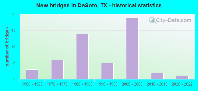
- New bridges - historical statistics
- 31960-1969
- 61970-1979
- 141980-1989
- 51990-1999
- 192000-2009
- 22010-2019
- 12020-2022
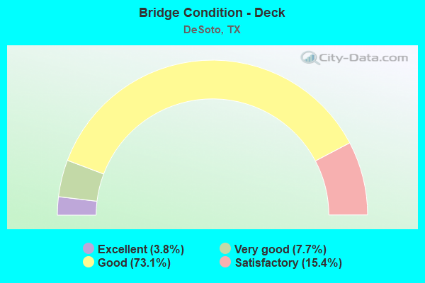
- Bridge Condition - Deck
- 3.8%Excellent
- 7.7%Very good
- 73.1%Good
- 15.4%Satisfactory
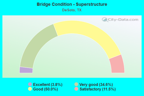
- Bridge Condition - Superstructure
- 3.8%Excellent
- 34.6%Very good
- 50.0%Good
- 11.5%Satisfactory
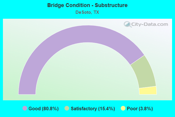
- Bridge Condition - Substructure
- 80.8%Good
- 15.4%Satisfactory
- 3.8%Poor
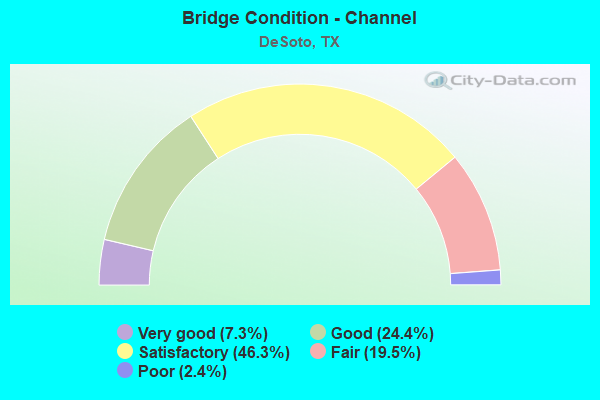
- Bridge Condition - Channel
- 7.3%Very good
- 24.4%Good
- 46.3%Satisfactory
- 19.5%Fair
- 2.4%Poor
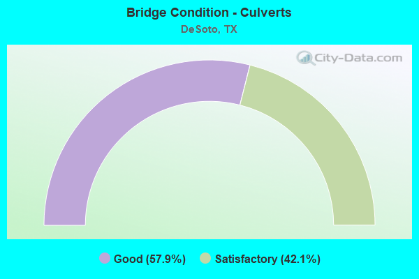
- Bridge Condition - Culverts
- 57.9%Good
- 42.1%Satisfactory
Find on map >> Show street view
Structure Number: 180570LG9078001, Location: 0.06 MI W of IH 35E (Lat: 32.621861, Lng: -96.824450), Route carried "on" structure: City street , Year Built: 2007, Status: Open, Structure Length: 1.65m (5.41ft), Average Daily Traffic: 231 (year 2019), Truck Traffic: 3%, Average Future Daily Traffic: 462 (year 2039), Design Load: HS 20, Features Intersected: TRIB TENMILE CREEK, Facility Carried by Structure: WINTERGREEN CT
Minimum Vertical Clearance: 30+ m (98+ ft), Kilometerpoint: 0.097, Lanes on structure: 2, Owner: City or Municipal Highway Agency, Approaching Roadway Width: 7.6m (24.9ft), Material/Design: Concrete, Design/Construction: Culvert, Number Of Spans In Main Unit: 5, Length of Maximum Span: 3.0m (9.8ft), Curb-To-Curb Width: 7.4m (24.3ft), Out-to-Out Width: 12.2m (40.0ft)
Condition: Channel: Good, Culverts: Good, Operating Rating: 54.4 metric tons, Method Used To Determine Operating Rating: Assigned rating based on Load Factor Design (LFD) reported in metric tons, Inventory Rating: 32.7 metric tons, Method Used To Determine Inventory Rating: Assigned rating based on Load Factor Design (LFD) reported in metric tons, Structural Evaluation: Better than present minimum criteria, Deck Geometry: Somewhat better than minimum adequacy, Waterway Adequacy: Superior to present desirable criteria, Approach Roadway Alignment: Equal to present desirable criteria, Designated Inspection Frequency: Every 24 months, Inspection Date: Febuary 2021, Deck Structure Type: Concrete Cast-file-Place, Wearing Surface/Protective System: Wearing Surface: Bituminous
Find on map >> Show street view
Structure Number: 180570LK3760001, Location: 0.05 MI S of Silver Creek (Lat: 32.595897, Lng: -96.882600), Route carried "on" structure: City street , Year Built: 2018, Status: Open, Structure Length: 1.04m (3.41ft), Average Daily Traffic: 231 (year 2019), Truck Traffic: 3%, Average Future Daily Traffic: 462 (year 2039), Features Intersected: HEATH CREEK, Facility Carried by Structure: N ELERSON RD
Minimum Vertical Clearance: 30+ m (98+ ft), Kilometerpoint: 0.080, Lanes on structure: 2, Owner: City or Municipal Highway Agency, Approaching Roadway Width: 11.0m (36.1ft), Skew: 3 degrees, Material/Design: Concrete, Design/Construction: Culvert, Number Of Spans In Main Unit: 3, Length of Maximum Span: 2.7m (8.9ft), Curb or Sidewalk Widths: Left: 0.0m, Right: 2.3m (7.5ft), Curb-To-Curb Width: 11.0m (36.1ft), Out-to-Out Width: 17.1m (56.1ft)
Condition: Channel: Very good, Culverts: Good, Operating Rating: 32.7 metric tons, Method Used To Determine Operating Rating: Field evaluation and documented engineering judgment, Inventory Rating: 24.5 metric tons, Method Used To Determine Inventory Rating: Field evaluation and documented engineering judgment, Structural Evaluation: Equal to present minimum criteria, Deck Geometry: Equal to present desirable criteria, Waterway Adequacy: Superior to present desirable criteria, Approach Roadway Alignment: Equal to present desirable criteria, Designated Inspection Frequency: Every 24 months, Inspection Date: Febuary 2021, Deck Structure Type: Concrete Cast-file-Place, Wearing Surface/Protective System: Wearing Surface: Monolithic Concrete
Find on map >> Show street view
Structure Number: 180570LZ4894001, Location: 0.10 MI E of Duncanville (Lat: 32.618608, Lng: -96.906444), Route carried "on" structure: City street , Year Built: 2021, Status: Open, Structure Length: 3.20m (10.50ft), Average Daily Traffic: 4,200 (year 2021), Truck Traffic: 3%, Average Future Daily Traffic: 5,900 (year 2021), Design Load: HL 93, Features Intersected: Stewart Branch, Facility Carried by Structure: Wintergreen Rd
Minimum Vertical Clearance: 30+ m (98+ ft), Kilometerpoint: 0.161, Lanes on structure: 4, Owner: City or Municipal Highway Agency, Approaching Roadway Width: 14.6m (47.9ft), Skew: 24 degrees, Material/Design: Prestressed concrete, Design/Construction: Stringer/Multi-beam, Number Of Spans In Main Unit: 1, Length of Maximum Span: 32.0m (105.0ft), Curb or Sidewalk Widths: Left: 1.6m (5.2ft), Right: 1.6m (5.2ft), Curb-To-Curb Width: 14.6m (47.9ft), Out-to-Out Width: 20.4m (66.9ft)
Condition: Deck: Excellent, Superstructure: Excellent, Substructure: Good, Channel: Good, Operating Rating: 54.4 metric tons, Method Used To Determine Operating Rating: Assigned ratings based on Load and Resistance Factor Design (LRFD) reported in metric tons, Inventory Rating: 32.7 metric tons, Method Used To Determine Inventory Rating: Assigned ratings based on Load and Resistance Factor Design (LRFD) reported in metric tons, Structural Evaluation: Better than present minimum criteria, Deck Geometry: High priority of replacement, Waterway Adequacy: Equal to present desirable criteria, Approach Roadway Alignment: Equal to present desirable criteria, Designated Inspection Frequency: Every 24 months, Inspection Date: June 2021, Deck Structure Type: Concrete Cast-file-Place
Find on map >> Show street view
Structure Number: 180570044202088, Location: 1.6 Mi S of IH 20 (Lat: 32.619161, Lng: -96.823306), Route carried "under" structure: City street , Year Built: 2005, Structure Length: 0. m, Average Daily Traffic: 12,346 (year 2020), Truck Traffic: 3%, Features Intersected: Wintergreen Rd, Facility Carried by Structure: IH 35E SB
Minimum Vertical Clearance: 5.72m (18.77ft), Kilometerpoint: 12.040, Lanes on structure: 5, Lanes under structure: 7, Material/Design: Prestressed concrete, Design/Construction: Stringer/Multi-beam, Length of Maximum Span: 37.5m (123.0ft)
Find on map >> Show street view
Structure Number: 18057004420209, Location: 2.6 Mi S of IH 20 (Lat: 32.604339, Lng: -96.823131), Route carried "under" structure: Interstate 35, Year Built: 2005, Structure Length: 0. m, Average Daily Traffic: 97,749 (year 2020), Truck Traffic: 16%, Features Intersected: IH 35E, Facility Carried by Structure: Pleasant Run Rd WB
Minimum Vertical Clearance: 6.35m (20.83ft), Kilometerpoint: 6.437, Lanes on structure: 5, Lanes under structure: 8, Material/Design: Prestressed concrete, Design/Construction: Stringer/Multi-beam, Length of Maximum Span: 28.3m (92.8ft)
Find on map >> Show street view
Structure Number: 180570044202091, Location: 2.6 Mi S of IH 20 (Lat: 32.604075, Lng: -96.823100), Route carried "under" structure: Interstate 35, Year Built: 2005, Structure Length: 0. m, Average Daily Traffic: 97,749 (year 2020), Truck Traffic: 16%, Features Intersected: IH 35E, Facility Carried by Structure: Pleasant Run Rd EB
Minimum Vertical Clearance: 6.19m (20.31ft), Kilometerpoint: 6.437, Lanes on structure: 5, Lanes under structure: 8, Material/Design: Prestressed concrete, Design/Construction: Stringer/Multi-beam, Length of Maximum Span: 28.3m (92.8ft)
Find on map >> Show street view
Structure Number: 180570044202093, Location: 3.6 Mi S of IH 20 (Lat: 32.588964, Lng: -96.822397), Route carried "under" structure: City street , Year Built: 2005, Structure Length: 0. m, Average Daily Traffic: 18,303 (year 2019), Truck Traffic: 3%, Features Intersected: Ten Mile Ck & BeltlineRd, Facility Carried by Structure: IH 35E SBML
Minimum Vertical Clearance: 5.51m (18.08ft), Kilometerpoint: 47.863, Lanes on structure: 4, Lanes under structure: 8, Material/Design: Prestressed concrete, Design/Construction: Stringer/Multi-beam, Length of Maximum Span: 40.2m (131.9ft)
Find on map >> Show street view
Structure Number: 180570044202348, Location: 4.6 Mi S of IH 20 (Lat: 32.575039, Lng: -96.822583), Route carried "under" structure: City street , Year Built: 2008, Structure Length: 0. m, Average Daily Traffic: 14,026 (year 2020), Truck Traffic: 3%, Features Intersected: Parkerville Rd, Facility Carried by Structure: IH 35E SB
Minimum Vertical Clearance: 5.39m (17.68ft), Kilometerpoint: 3.288, Lanes on structure: 3, Lanes under structure: 2, Material/Design: Prestressed concrete, Design/Construction: Stringer/Multi-beam, Length of Maximum Span: 36.0m (118.1ft)