Bridge Statistics for Dearborn, Michigan (MI)
Condition, Traffic, Stress, Structural Evaluation, Project Costs
- National Bridge Inventory (NBI) Statistics
- 122Number of bridges
- 1,293ft / 394mTotal length
- $1,713,000Total costs
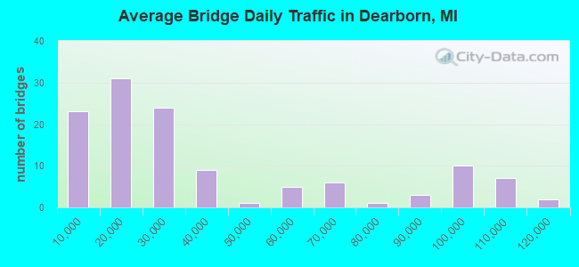
- 4,435,331Total average daily traffic
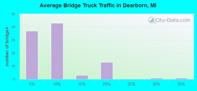
- 319,160Total average daily truck traffic
- National Bridge Inventory (NBI) Registered Bridges for Dearborn
- No street view available for this location
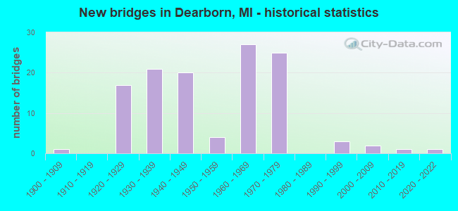
- New bridges - historical statistics
- 11900-1909
- 171920-1929
- 211930-1939
- 201940-1949
- 41950-1959
- 271960-1969
- 251970-1979
- 31990-1999
- 22000-2009
- 12010-2019
- 12020-2022
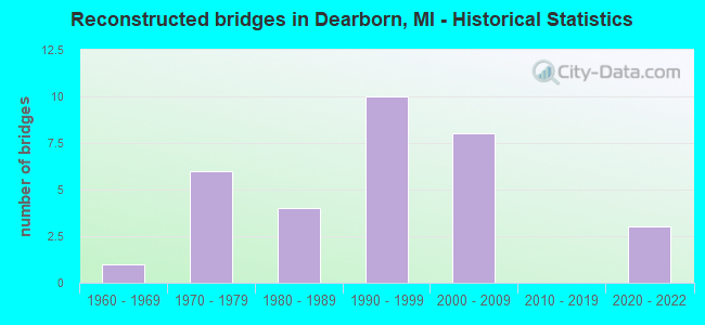
- Reconstructed bridges - Historical Statistics
- 11960-1969
- 61970-1979
- 41980-1989
- 101990-1999
- 82000-2009
- 02010-2019
- 32020-2022
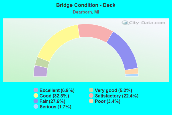
- Bridge Condition - Deck
- 6.9%Excellent
- 5.2%Very good
- 32.8%Good
- 22.4%Satisfactory
- 27.6%Fair
- 3.4%Poor
- 1.7%Serious
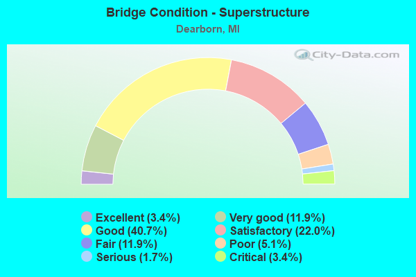
- Bridge Condition - Superstructure
- 3.4%Excellent
- 11.9%Very good
- 40.7%Good
- 22.0%Satisfactory
- 11.9%Fair
- 5.1%Poor
- 1.7%Serious
- 3.4%Critical
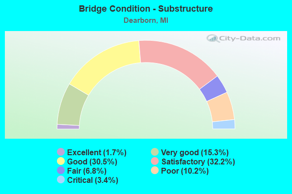
- Bridge Condition - Substructure
- 1.7%Excellent
- 15.3%Very good
- 30.5%Good
- 32.2%Satisfactory
- 6.8%Fair
- 10.2%Poor
- 3.4%Critical
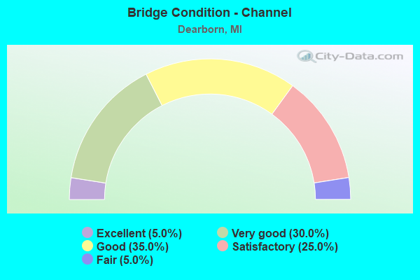
- Bridge Condition - Channel
- 5.0%Excellent
- 30.0%Very good
- 35.0%Good
- 25.0%Satisfactory
- 5.0%Fair
Find on map >> Show street view
Structure Number: 11675, Location: IN DEARBORN (Lat: 42.307386, Lng: -83.214608), Route carried "on" structure: ServiceState highway 39, Year Built: 1963, Status: Open, Structure Length: 10.36m (33.99ft), Average Daily Traffic: 19,480 (year 1982), Truck Traffic: 3%, Average Future Daily Traffic: 19,480 (year 2000), Design Load: HS 20+Mod, Features Intersected: ROUGE RIVER
Minimum Vertical Clearance: 30.48m (100.00ft), Kilometerpoint: 5.039, Lanes on structure: 2, Owner: State Highway Agency, Approaching Roadway Width: 11.0m (36.1ft), Material/Design: Steel continuous, Design/Construction: Stringer/Multi-beam, Number Of Spans In Main Unit: 5, Length of Maximum Span: 27.4m (89.9ft), Curb or Sidewalk Widths: Left: 1.7m (5.6ft), Right: 0.0m, Curb-To-Curb Width: 9.1m (29.9ft), Out-to-Out Width: 12.0m (39.4ft)
Condition: Deck: Satisfactory, Superstructure: Satisfactory, Substructure: Good, Channel: Very good, Operating Rating: 54.8 metric tons, Method Used To Determine Operating Rating: Load Factor (LF) rating reported by rating factor (RF) method using MS18 loading, Inventory Rating: 32.7 metric tons, Method Used To Determine Inventory Rating: Load Factor (LF) rating reported by rating factor (RF) method using MS18 loading, Structural Evaluation: Equal to present minimum criteria, Deck Geometry: Meets minimum limits, Waterway Adequacy: Equal to present desirable criteria, Approach Roadway Alignment: Equal to present desirable criteria, Designated Inspection Frequency: Every 24 months, Inspection Date: October 2021, Deck Structure Type: Concrete Cast-file-Place, Wearing Surface/Protective System: Wearing Surface: Bituminous
Find on map >> Show street view
Structure Number: 11683, Location: IN DEARBORN (Lat: 42.298478, Lng: -83.206022), Route carried "on" structure: County highway 2057, Year Built: 1964, Year Reconstructed: 2005, Status: Open, Structure Length: 5.48m (17.98ft), Average Daily Traffic: 30,000 (year 2005), Truck Traffic: 6%, Average Future Daily Traffic: 30,200 (year 2026), Design Load: HS 20, Features Intersected: M-39, Facility Carried by Structure: ROTUNDA DRIVE
Minimum Vertical Clearance: 30.48m (100.00ft), Kilometerpoint: 3.071, Lanes on structure: 8, Lanes under structure: 6, Owner: State Highway Agency, Approaching Roadway Width: 14.6m (47.9ft), Material/Design: Prestressed concrete, Design/Construction: Box Beam or Girders - Single/Spread, Number Of Spans In Main Unit: 4, Length of Maximum Span: 16.7m (54.8ft), Curb or Sidewalk Widths: Left: 3.0m (9.8ft), Right: 3.0m (9.8ft), Curb-To-Curb Width: 35.9m (117.8ft), Out-to-Out Width: 42.7m (140.1ft)
Condition: Deck: Very good, Superstructure: Good, Substructure: Good, Operating Rating: 59.9 metric tons, Method Used To Determine Operating Rating: Load Factor (LF) rating reported by rating factor (RF) method using MS18 loading, Inventory Rating: 36.0 metric tons, Method Used To Determine Inventory Rating: Load Factor (LF) rating reported by rating factor (RF) method using MS18 loading, Structural Evaluation: Better than present minimum criteria, Deck Geometry: Superior to present desirable criteria, Underclear: High priority of corrective action, Approach Roadway Alignment: Equal to present desirable criteria, Designated Inspection Frequency: Every 24 months, Inspection Date: May 2020, Deck Structure Type: Concrete Cast-file-Place, Wearing Surface/Protective System: Wearing Surface: Monolithic Concrete, Membrane: Epoxy, Deck Protection: Epoxy Coated Reinforcing
Find on map >> Show street view
Structure Number: 11684, Location: 0.25 MILES S OF RIVER RD (Lat: 42.305006, Lng: -83.212503), Route carried "on" structure: Other road , Year Built: 1964, Year Reconstructed: 2001, Status: Open, Structure Length: 5.55m (18.21ft), Average Daily Traffic: 4,500 (year 1988), Average Future Daily Traffic: 270 (year 1977), Design Load: HS 25 or greater, Features Intersected: M-39, Facility Carried by Structure: VILLAGE RD
Minimum Vertical Clearance: 30.48m (100.00ft), Kilometerpoint: 3.600, Lanes on structure: 4, Lanes under structure: 6, Owner: State Highway Agency, Approaching Roadway Width: 14.1m (46.3ft), Material/Design: Steel continuous, Design/Construction: Stringer/Multi-beam, Number Of Spans In Main Unit: 4, Length of Maximum Span: 18.3m (60.0ft), Curb or Sidewalk Widths: Left: 1.6m (5.2ft), Right: 1.6m (5.2ft), Curb-To-Curb Width: 14.1m (46.3ft), Out-to-Out Width: 18.0m (59.1ft)
Condition: Deck: Very good, Superstructure: Good, Substructure: Satisfactory, Operating Rating: 71.1 metric tons, Method Used To Determine Operating Rating: Load Factor (LF), Inventory Rating: 42.6 metric tons, Method Used To Determine Inventory Rating: Load Factor (LF), Structural Evaluation: Equal to present minimum criteria, Deck Geometry: High priority of replacement, Underclear: High priority of corrective action, Approach Roadway Alignment: Equal to present desirable criteria, Designated Inspection Frequency: Every 24 months, Inspection Date: November 2021, Deck Structure Type: Concrete Cast-file-Place, Wearing Surface/Protective System: Wearing Surface: Monolithic Concrete, Deck Protection: Epoxy Coated Reinforcing
Find on map >> Show street view
Structure Number: 11685, Location: IN DEARBORN (Lat: 42.321561, Lng: -83.215217), Route carried "on" structure: County highway 2057, Year Built: 1964, Year Reconstructed: 1996, Status: Open, Structure Length: 5.41m (17.75ft), Average Daily Traffic: 15,457 (year 2010), Truck Traffic: 3%, Average Future Daily Traffic: 17,003 (year 2025), Design Load: HS 20, Features Intersected: M-39, Facility Carried by Structure: HUBBARD AV EB
Minimum Vertical Clearance: 30.48m (100.00ft), Kilometerpoint: 1.410, Lanes on structure: 4, Lanes under structure: 6, Owner: State Highway Agency, Approaching Roadway Width: 14.6m (47.9ft), Skew: 10 degrees, Material/Design: Steel continuous, Design/Construction: Stringer/Multi-beam, Number Of Spans In Main Unit: 4, Length of Maximum Span: 18.1m (59.4ft), Curb or Sidewalk Widths: Left: 0.0m, Right: 3.0m (9.8ft), Curb-To-Curb Width: 17.2m (56.4ft), Out-to-Out Width: 21.2m (69.6ft)
Condition: Deck: Satisfactory, Superstructure: Satisfactory, Substructure: Poor, Operating Rating: 65.1 metric tons, Method Used To Determine Operating Rating: Load Factor (LF) rating reported by rating factor (RF) method using MS18 loading, Inventory Rating: 38.9 metric tons, Method Used To Determine Inventory Rating: Load Factor (LF) rating reported by rating factor (RF) method using MS18 loading, Structural Evaluation: Meets minimum limits, Deck Geometry: Somewhat better than minimum adequacy, Underclear: High priority of corrective action, Approach Roadway Alignment: Equal to present desirable criteria, Designated Inspection Frequency: Every 24 months, Other Special Inspection Frequency: Every 24 months, Inspection Date: November 2021, Other Special Inspection Date: November 2020, Deck Structure Type: Concrete Cast-file-Place, Wearing Surface/Protective System: Wearing Surface: Monolithic Concrete
Find on map >> Show street view
Structure Number: 11686, Location: IN DEARBORN (Lat: 42.321761, Lng: -83.215225), Route carried "on" structure: County highway 2057, Year Built: 1964, Year Reconstructed: 1996, Status: Open, Structure Length: 5.41m (17.75ft), Average Daily Traffic: 15,457 (year 2010), Truck Traffic: 3%, Average Future Daily Traffic: 17,003 (year 2025), Design Load: HS 20, Features Intersected: M-39, Facility Carried by Structure: HUBBARD AV WB
Minimum Vertical Clearance: 30.48m (100.00ft), Kilometerpoint: 1.399, Lanes on structure: 4, Lanes under structure: 6, Owner: State Highway Agency, Approaching Roadway Width: 14.6m (47.9ft), Skew: 10 degrees, Material/Design: Steel continuous, Design/Construction: Stringer/Multi-beam, Number Of Spans In Main Unit: 4, Length of Maximum Span: 18.1m (59.4ft), Curb or Sidewalk Widths: Left: 0.0m, Right: 3.0m (9.8ft), Curb-To-Curb Width: 17.2m (56.4ft), Out-to-Out Width: 21.2m (69.6ft)
Condition: Deck: Good, Superstructure: Good, Substructure: Poor, Operating Rating: 65.8 metric tons, Method Used To Determine Operating Rating: Load Factor (LF) rating reported by rating factor (RF) method using MS18 loading, Inventory Rating: 39.2 metric tons, Method Used To Determine Inventory Rating: Load Factor (LF) rating reported by rating factor (RF) method using MS18 loading, Structural Evaluation: Meets minimum limits, Deck Geometry: Somewhat better than minimum adequacy, Underclear: High priority of corrective action, Approach Roadway Alignment: Equal to present desirable criteria, Designated Inspection Frequency: Every 24 months, Other Special Inspection Frequency: Every 24 months, Inspection Date: November 2021, Other Special Inspection Date: November 2020, Deck Structure Type: Concrete Cast-file-Place, Wearing Surface/Protective System: Wearing Surface: Monolithic Concrete
Find on map >> Show street view
Structure Number: 12049, Location: DEARBORN E/SOUTHFIELD (Lat: 42.301161, Lng: -83.199125), Route carried "on" structure: County highway 2057, Year Built: 1964, Status: Posted for load, Structure Length: 11.46m (37.60ft), Average Daily Traffic: 30,846 (year 1995), Truck Traffic: 5%, Average Future Daily Traffic: 25,463 (year 2015), Design Load: HS 20, Features Intersected: ROUGE RIVER (RE-LOCATED), Facility Carried by Structure: ROTUNDA DRIVE
Minimum Vertical Clearance: 30.48m (100.00ft), Kilometerpoint: 3.713, Lanes on structure: 7, Owner: County Highway Agency, Approaching Roadway Width: 21.3m (69.9ft), Skew: 2 degrees, Material/Design: Prestressed concrete, Design/Construction: Stringer/Multi-beam, Number Of Spans In Main Unit: 6, Length of Maximum Span: 19.2m (63.0ft), Curb or Sidewalk Widths: Left: 2.5m (8.2ft), Right: 2.5m (8.2ft), Curb-To-Curb Width: 24.1m (79.1ft), Out-to-Out Width: 29.7m (97.4ft)
Condition: Deck: Fair, Superstructure: Satisfactory, Substructure: Poor, Channel: Satisfactory, Operating Rating: 54.4 metric tons, Method Used To Determine Operating Rating: Load Factor (LF) rating reported by rating factor (RF) method using MS18 loading, Inventory Rating: 27.9 metric tons, Method Used To Determine Inventory Rating: Load Factor (LF) rating reported by rating factor (RF) method using MS18 loading, Structural Evaluation: Meets minimum limits, Deck Geometry: High priority of replacement, Waterway Adequacy: Equal to present desirable criteria, Approach Roadway Alignment: Equal to present desirable criteria, Bridge Posting: Required (Relationship of Operating Rating to Maximum Legal Load: 10.0 - 19.9% below), Designated Inspection Frequency: Every 12 months, Underwater Inspection Frequency: Every 60 months, Inspection Date: May 2021, Underwater Inspection Date: August 2019, Deck Structure Type: Concrete Cast-file-Place, Wearing Surface/Protective System: Wearing Surface: Bituminous
Find on map >> Show street view
Structure Number: 1205, Location: DEARBORN N/I-94 (Lat: 42.305622, Lng: -83.186867), Route carried "on" structure: County highway 2057, Year Built: 1961, Status: Open, Structure Length: 3.32m (10.89ft), Average Daily Traffic: 21,821 (year 1997), Truck Traffic: 5%, Average Future Daily Traffic: 24,000 (year 2015), Design Load: HS 20+Mod, Features Intersected: ROTUNDA DRIVE, Facility Carried by Structure: GREENFIELD ROAD
Minimum Vertical Clearance: 30.48m (100.00ft), Kilometerpoint: 4.152, Lanes on structure: 10, Lanes under structure: 4, Base Highway Network: Yes (Inventory Route: 165, Subroute: 2), Owner: County Highway Agency, Approaching Roadway Width: 27.4m (89.9ft), Material/Design: Steel continuous, Design/Construction: Stringer/Multi-beam, Number Of Spans In Main Unit: 2, Length of Maximum Span: 16.7m (54.8ft), Curb or Sidewalk Widths: Left: 3.0m (9.8ft), Right: 3.0m (9.8ft), Curb-To-Curb Width: 27.4m (89.9ft), Out-to-Out Width: 45.4m (149.0ft)
Condition: Deck: Fair, Superstructure: Good, Substructure: Satisfactory, Operating Rating: 69.0 metric tons, Method Used To Determine Operating Rating: Load Factor (LF) rating reported by rating factor (RF) method using MS18 loading, Inventory Rating: 41.1 metric tons, Method Used To Determine Inventory Rating: Load Factor (LF) rating reported by rating factor (RF) method using MS18 loading, Structural Evaluation: Equal to present minimum criteria, Deck Geometry: High priority of replacement, Underclear: Somewhat better than minimum adequacy, Approach Roadway Alignment: Equal to present desirable criteria, Designated Inspection Frequency: Every 24 months, Inspection Date: October 2020, Deck Structure Type: Concrete Cast-file-Place, Wearing Surface/Protective System: Wearing Surface: Bituminous
Find on map >> Show street view
Structure Number: 12052, Location: DEARBORN N/I-94 (Lat: 42.314042, Lng: -83.175606), Route carried "on" structure: County highway 2057, Year Built: 1932, Year Reconstructed: 1987, Status: Open, Structure Length: 2.89m (9.48ft), Average Daily Traffic: 18,726 (year 1995), Truck Traffic: 8%, Average Future Daily Traffic: 8,923 (year 2015), Design Load: HS 20, Features Intersected: SCHAEFER ROAD, Facility Carried by Structure: ROTUNDA DRIVE
Minimum Vertical Clearance: 30.48m (100.00ft), Kilometerpoint: 6.264, Lanes on structure: 4, Lanes under structure: 4, Owner: County Highway Agency, Approaching Roadway Width: 15.2m (49.9ft), Material/Design: Prestressed concrete, Design/Construction: Stringer/Multi-beam, Number Of Spans In Main Unit: 4, Length of Maximum Span: 9.4m (30.8ft), Curb or Sidewalk Widths: Left: 1.5m (4.9ft), Right: 1.5m (4.9ft), Curb-To-Curb Width: 18.2m (59.7ft), Out-to-Out Width: 22.1m (72.5ft)
Condition: Deck: Satisfactory, Superstructure: Good, Substructure: Poor, Operating Rating: 42.4 metric tons, Method Used To Determine Operating Rating: Load Factor (LF) rating reported by rating factor (RF) method using MS18 loading, Inventory Rating: 24.6 metric tons, Method Used To Determine Inventory Rating: Load Factor (LF) rating reported by rating factor (RF) method using MS18 loading, Structural Evaluation: Meets minimum limits, Deck Geometry: Somewhat better than minimum adequacy, Underclear: High priority of corrective action, Approach Roadway Alignment: Equal to present desirable criteria, Designated Inspection Frequency: Every 12 months, Inspection Date: October 2021, Deck Structure Type: Concrete Cast-file-Place, Wearing Surface/Protective System: Wearing Surface: Monolithic Concrete, Membrane: Other, Deck Protection: Epoxy Coated Reinforcing
Find on map >> Show street view
Structure Number: 12053, Location: DEARBORN S / MICHIGAN AVE (Lat: 42.316083, Lng: -83.163111), Route carried "on" structure: County highway 2057, Year Built: 1931, Year Reconstructed: 1983, Status: Temporarily open, Structure Length: 14.57m (47.80ft), Average Daily Traffic: 8,816 (year 1992), Average Future Daily Traffic: 10,138 (year 2012), Design Load: HS 20+Mod, Features Intersected: OPEN AREA, Facility Carried by Structure: ROTUNDA DRIVE
Minimum Vertical Clearance: 30.48m (100.00ft), Kilometerpoint: 7.320, Lanes on structure: 5, Owner: County Highway Agency, Approaching Roadway Width: 23.5m (77.1ft), Material/Design: Steel, Design/Construction: Stringer/Multi-beam, Number Of Spans In Main Unit: 19, Length of Maximum Span: 7.6m (24.9ft), Curb or Sidewalk Widths: Left: 2.0m (6.6ft), Right: 2.0m (6.6ft), Curb-To-Curb Width: 19.5m (64.0ft), Out-to-Out Width: 24.3m (79.7ft)
Condition: Deck: Poor, Superstructure: Critical, Substructure: Critical, Structural Evaluation: High priority of replacement, Deck Geometry: Meets minimum limits, Approach Roadway Alignment: Equal to present desirable criteria, Designated Inspection Frequency: Every 6 months, Critical Feature Inspection Frequency: Every 12 months, Inspection Date: October 2021, Critical Feature Inspection Date: October 2021, Deck Structure Type: Concrete Cast-file-Place, Wearing Surface/Protective System: Wearing Surface: Monolithic Concrete, Deck Protection: Galvanized Reinforcing
Find on map >> Show street view
Structure Number: 12055, Location: DBN HTS W/ANN ARBOR TRAIL (Lat: 42.341714, Lng: -83.263181), Route carried "on" structure: County highway 2057, Year Built: 1957, Status: Open, Structure Length: 2.25m (7.38ft), Average Daily Traffic: 16,260 (year 2014), Truck Traffic: 7%, Average Future Daily Traffic: 16,425 (year 2034), Design Load: HS 20+Mod, Features Intersected: E N HINES DRIVE, Facility Carried by Structure: WARREN AVENUE
Minimum Vertical Clearance: 30.48m (100.00ft), Kilometerpoint: 24.004, Lanes on structure: 5, Lanes under structure: 2, Base Highway Network: Yes (Inventory Route: 471, Subroute: 70), Owner: County Highway Agency, Approaching Roadway Width: 18.7m (61.4ft), Material/Design: Concrete, Design/Construction: Frame, Number Of Spans In Main Unit: 1, Length of Maximum Span: 20.1m (65.9ft), Curb or Sidewalk Widths: Left: 2.4m (7.9ft), Right: 2.4m (7.9ft), Curb-To-Curb Width: 18.3m (60.0ft), Out-to-Out Width: 23.8m (78.1ft)
Condition: Deck: Satisfactory, Superstructure: Satisfactory, Substructure: Good, Operating Rating: 65.4 metric tons, Method Used To Determine Operating Rating: Load Factor (LF) rating reported by rating factor (RF) method using MS18 loading, Inventory Rating: 39.2 metric tons, Method Used To Determine Inventory Rating: Load Factor (LF) rating reported by rating factor (RF) method using MS18 loading, Structural Evaluation: Equal to present minimum criteria, Deck Geometry: High priority of replacement, Underclear: Meets minimum limits, Approach Roadway Alignment: Equal to present desirable criteria, Designated Inspection Frequency: Every 24 months, Inspection Date: September 2020, Deck Structure Type: Concrete Cast-file-Place, Wearing Surface/Protective System: Wearing Surface: Epoxy Overlay
Find on map >> Show street view
Structure Number: 12177, Location: DEARBORN N/MICHIGAN (Lat: 42.310889, Lng: -83.226508), Route carried "on" structure: County highway 2057, Year Built: 1975, Status: Open, Structure Length: 10.21m (33.50ft), Average Daily Traffic: 28,663 (year 1995), Truck Traffic: 5%, Average Future Daily Traffic: 27,066 (year 2015), Design Load: HS 20+Mod, Features Intersected: ROUGE RIVER, Facility Carried by Structure: EVERGREEN ROAD
Minimum Vertical Clearance: 30.48m (100.00ft), Kilometerpoint: 0.314, Lanes on structure: 8, Base Highway Network: Yes (Inventory Route: 159, Subroute: 8), Owner: County Highway Agency, Approaching Roadway Width: 30.4m (99.7ft), Skew: 10 degrees, Material/Design: Steel continuous, Design/Construction: Stringer/Multi-beam, Number Of Spans In Main Unit: 3, Length of Maximum Span: 37.8m (124.0ft), Curb or Sidewalk Widths: Left: 1.4m (4.6ft), Right: 4.8m (15.7ft), Curb-To-Curb Width: 30.5m (100.1ft), Out-to-Out Width: 51.9m (170.3ft)
Condition: Deck: Fair, Superstructure: Satisfactory, Substructure: Poor, Channel: Satisfactory, Operating Rating: 74.2 metric tons, Method Used To Determine Operating Rating: Load Factor (LF) rating reported by rating factor (RF) method using MS18 loading, Inventory Rating: 44.4 metric tons, Method Used To Determine Inventory Rating: Load Factor (LF) rating reported by rating factor (RF) method using MS18 loading, Structural Evaluation: Meets minimum limits, Deck Geometry: Somewhat better than minimum adequacy, Waterway Adequacy: Equal to present desirable criteria, Approach Roadway Alignment: Equal to present desirable criteria, Designated Inspection Frequency: Every 12 months, Underwater Inspection Frequency: Every 24 months, Inspection Date: June 2021, Underwater Inspection Date: August 2021, Deck Structure Type: Concrete Cast-file-Place, Wearing Surface/Protective System: Wearing Surface: Latex Concrete
Find on map >> Show street view
Structure Number: 12179, Location: DEARBORN N/MICHIGAN (Lat: 42.303850, Lng: -83.263361), Route carried "on" structure: County highway 2057, Year Built: 1930, Status: Open, Structure Length: 2.22m (7.28ft), Average Daily Traffic: 26,269 (year 1997), Truck Traffic: 5%, Average Future Daily Traffic: 20,547 (year 2015), Design Load: HS 20+Mod, Features Intersected: LOWER ROUGE RIVER, Facility Carried by Structure: OUTER DRIVE
Minimum Vertical Clearance: 30.48m (100.00ft), Kilometerpoint: 1.798, Lanes on structure: 5, Base Highway Network: Yes (Inventory Route: 471, Subroute: 71), Owner: County Highway Agency, Approaching Roadway Width: 22.6m (74.1ft), Material/Design: Concrete, Design/Construction: Arch - Deck, Number Of Spans In Main Unit: 1, Length of Maximum Span: 19.2m (63.0ft), Curb or Sidewalk Widths: Left: 3.1m (10.2ft), Right: 3.1m (10.2ft), Curb-To-Curb Width: 18.3m (60.0ft), Out-to-Out Width: 25.6m (84.0ft)
Condition: Superstructure: Fair, Substructure: Satisfactory, Channel: Satisfactory, Operating Rating: 52.2 metric tons, Method Used To Determine Operating Rating: Load Factor (LF) rating reported by rating factor (RF) method using MS18 loading, Inventory Rating: 31.1 metric tons, Method Used To Determine Inventory Rating: Load Factor (LF) rating reported by rating factor (RF) method using MS18 loading, Structural Evaluation: Somewhat better than minimum adequacy, Deck Geometry: High priority of replacement, Waterway Adequacy: Equal to present desirable criteria, Approach Roadway Alignment: Equal to present desirable criteria, Designated Inspection Frequency: Every 24 months, Inspection Date: September 2020
Find on map >> Show street view
Structure Number: 12229, Location: DEARBORN/DETROIT W/MILLER (Lat: 42.296703, Lng: -83.150728), Route carried "on" structure: County highway 2057, Year Built: 1927, Year Reconstructed: 1989, Status: Open, Structure Length: 6.76m (22.18ft), Average Daily Traffic: 11,218 (year 1996), Truck Traffic: 5%, Average Future Daily Traffic: 7,451 (year 2015), Features Intersected: ROUGE RIVER, Facility Carried by Structure: DIX ROAD
Minimum Vertical Clearance: 30.48m (100.00ft), Kilometerpoint: 1.780, Lanes on structure: 4, Base Highway Network: Yes (Inventory Route: 162, Subroute: 3), Owner: County Highway Agency, Approaching Roadway Width: 22.6m (74.1ft), Navigation Control: Yes ( Vertical Clearance: 3.0m (9.8ft), Horizontal Clearance: 23.0m (75.5ft)), Material/Design: Steel, Design/Construction: Movable - Bascule, Number Of Spans In Main Unit: 2, Number Of Approach Spans: 4, Length of Maximum Span: 50.0m (164.0ft), Curb or Sidewalk Widths: Left: 2.4m (7.9ft), Right: 2.4m (7.9ft), Curb-To-Curb Width: 17.1m (56.1ft), Out-to-Out Width: 22.5m (73.8ft)
Condition: Deck: Fair, Superstructure: Poor, Substructure: Fair, Channel: Good, Operating Rating: 33.0 metric tons, Method Used To Determine Operating Rating: Load and Resistance Factor Rating (LRFR) rating reported by rating factor(RF) method using HL-93 loadings, Inventory Rating: 25.3 metric tons, Method Used To Determine Inventory Rating: Load and Resistance Factor Rating (LRFR) rating reported by rating factor(RF) method using HL-93 loadings, Structural Evaluation: Meets minimum limits, Deck Geometry: Somewhat better than minimum adequacy, Waterway Adequacy: Equal to present desirable criteria, Approach Roadway Alignment: Equal to present desirable criteria, Designated Inspection Frequency: Every 12 months, Critical Feature Inspection Frequency: Every 24 months, Underwater Inspection Frequency: Every 60 months, Inspection Date: June 2021, Critical Feature Inspection Date: June 2021, Underwater Inspection Date: November 2018, Deck Structure Type: Closed Grating, Wearing Surface/Protective System: Wearing Surface: Monolithic Concrete, Deck Protection: Epoxy Coated Reinforcing
Find on map >> Show street view
Structure Number: 1223, Location: DEARBORN N/MILLER (Lat: 42.300792, Lng: -83.147644), Route carried "on" structure: City street 2057, Year Built: 1930, Status: Open, Structure Length: 4.54m (14.90ft), Average Daily Traffic: 10,257 (year 1990), Truck Traffic: 5%, Average Future Daily Traffic: 10,257 (year 2015), Design Load: HS 20+Mod, Features Intersected: DIX ROAD, Facility Carried by Structure: INDUSTRIAL ROAD
Minimum Vertical Clearance: 30.48m (100.00ft), Kilometerpoint: 3.011, Lanes on structure: 4, Lanes under structure: 6, Owner: County Highway Agency, Approaching Roadway Width: 14.6m (47.9ft), Material/Design: Steel, Design/Construction: Stringer/Multi-beam, Number Of Spans In Main Unit: 2, Number Of Approach Spans: 2, Length of Maximum Span: 12.5m (41.0ft), Curb or Sidewalk Widths: Left: 1.9m (6.2ft), Right: 5.7m (18.7ft), Curb-To-Curb Width: 14.6m (47.9ft), Out-to-Out Width: 23.7m (77.8ft)
Condition: Deck: Serious, Superstructure: Serious, Substructure: Poor, Operating Rating: 97.2 metric tons, Method Used To Determine Operating Rating: Load Factor (LF) rating reported by rating factor (RF) method using MS18 loading, Inventory Rating: 68.7 metric tons, Method Used To Determine Inventory Rating: Load Factor (LF) rating reported by rating factor (RF) method using MS18 loading, Structural Evaluation: High priority of corrective action, Deck Geometry: High priority of replacement, Underclear: High priority of corrective action, Approach Roadway Alignment: Equal to present desirable criteria, Designated Inspection Frequency: Every 12 months, Inspection Date: May 2021, Deck Structure Type: Concrete Cast-file-Place, Wearing Surface/Protective System: Wearing Surface: Bituminous
Find on map >> Show street view
Structure Number: 12233, Location: DEARBORN/MELVINDAL S/I-94 (Lat: 42.294375, Lng: -83.179089), Route carried "on" structure: County highway 2057, Year Built: 1928, Year Reconstructed: 2002, Status: Open, Structure Length: 11.06m (36.29ft), Average Daily Traffic: 11,655 (year 1997), Truck Traffic: 7%, Average Future Daily Traffic: 10,439 (year 2015), Design Load: HS 20+Mod, Features Intersected: ROUGE RIVER, Facility Carried by Structure: GREENFIELD ROAD
Minimum Vertical Clearance: 30.48m (100.00ft), Kilometerpoint: 2.796, Lanes on structure: 5, Base Highway Network: Yes (Inventory Route: 165, Subroute: 2), Owner: County Highway Agency, Approaching Roadway Width: 18.3m (60.0ft), Skew: 1 degrees, Material/Design: Prestressed concrete, Design/Construction: Tee Beam, Number Of Spans In Main Unit: 7, Number Of Approach Spans: 3, Length of Maximum Span: 16.7m (54.8ft), Curb or Sidewalk Widths: Left: 2.5m (8.2ft), Right: 2.5m (8.2ft), Curb-To-Curb Width: 18.3m (60.0ft), Out-to-Out Width: 23.9m (78.4ft)
Condition: Deck: Fair, Superstructure: Satisfactory, Substructure: Fair, Channel: Good, Operating Rating: 82.3 metric tons, Method Used To Determine Operating Rating: Load Factor (LF) rating reported by rating factor (RF) method using MS18 loading, Inventory Rating: 49.2 metric tons, Method Used To Determine Inventory Rating: Load Factor (LF) rating reported by rating factor (RF) method using MS18 loading, Structural Evaluation: Somewhat better than minimum adequacy, Deck Geometry: High priority of replacement, Waterway Adequacy: Equal to present desirable criteria, Approach Roadway Alignment: Equal to present desirable criteria, Designated Inspection Frequency: Every 24 months, Inspection Date: October 2020, Deck Structure Type: Concrete Cast-file-Place, Wearing Surface/Protective System: Wearing Surface: Bituminous
Find on map >> Show street view
Structure Number: 12237, Location: DEARBORN S/MICHIGAN (Lat: 42.318214, Lng: -83.157769), Route carried "on" structure: City street 2057, Year Built: 1925, Status: Open, Structure Length: 2.89m (9.48ft), Average Daily Traffic: 3,000 (year 1987), Truck Traffic: 5%, Average Future Daily Traffic: 21,246 (year 2015), Design Load: HS 20+Mod, Features Intersected: WYOMING AVENUE, Facility Carried by Structure: SOUTHERN AVENUE
Minimum Vertical Clearance: 30.48m (100.00ft), Kilometerpoint: 0.430, Lanes on structure: 4, Lanes under structure: 4, Owner: County Highway Agency, Approaching Roadway Width: 11.8m (38.7ft), Material/Design: Steel continuous, Design/Construction: Stringer/Multi-beam, Number Of Spans In Main Unit: 2, Number Of Approach Spans: 2, Length of Maximum Span: 9.7m (31.8ft), Curb or Sidewalk Widths: Left: 0.1m (0.3ft), Right: 2.3m (7.5ft), Curb-To-Curb Width: 10.9m (35.8ft), Out-to-Out Width: 14.7m (48.2ft)
Condition: Deck: Satisfactory, Superstructure: Fair, Substructure: Fair, Operating Rating: 50.5 metric tons, Method Used To Determine Operating Rating: Load Factor (LF) rating reported by rating factor (RF) method using MS18 loading, Inventory Rating: 30.5 metric tons, Method Used To Determine Inventory Rating: Load Factor (LF) rating reported by rating factor (RF) method using MS18 loading, Structural Evaluation: Somewhat better than minimum adequacy, Deck Geometry: High priority of replacement, Underclear: High priority of corrective action, Approach Roadway Alignment: Somewhat better than minimum adequacy, Designated Inspection Frequency: Every 24 months, Inspection Date: October 2020, Deck Structure Type: Concrete Cast-file-Place, Wearing Surface/Protective System: Wearing Surface: Integral Concrete, Deck Protection: Epoxy Coated Reinforcing
Find on map >> Show street view
Structure Number: 12239, Location: DEARBORN S/MICHIGAN (Lat: 42.317111, Lng: -83.162567), Route carried "on" structure: County highway 2057, Year Built: 1931, Year Reconstructed: 1982, Status: Temporarily open, Structure Length: 44.51m (146.03ft), Average Daily Traffic: 23,965 (year 1995), Truck Traffic: 8%, Average Future Daily Traffic: 22,000 (year 2015), Design Load: HS 20+Mod, Features Intersected: CONRAIL, Facility Carried by Structure: MILLER ROAD
Minimum Vertical Clearance: 30.48m (100.00ft), Kilometerpoint: 3.454, Lanes on structure: 6, Owner: County Highway Agency, Approaching Roadway Width: 26.5m (86.9ft), Skew: 1 degrees, Material/Design: Steel, Design/Construction: Stringer/Multi-beam, Number Of Spans In Main Unit: 48, Length of Maximum Span: 18.9m (62.0ft), Curb or Sidewalk Widths: Left: 2.1m (6.9ft), Right: 0.3m (1.0ft), Curb-To-Curb Width: 18.9m (62.0ft), Out-to-Out Width: 21.9m (71.9ft)
Condition: Deck: Fair, Superstructure: Critical, Substructure: Critical, Structural Evaluation: High priority of replacement, Deck Geometry: High priority of replacement, Approach Roadway Alignment: Equal to present desirable criteria, Designated Inspection Frequency: Every 6 months, Critical Feature Inspection Frequency: Every 12 months, Inspection Date: October 2021, Critical Feature Inspection Date: October 2021, Deck Structure Type: Concrete Cast-file-Place, Wearing Surface/Protective System: Wearing Surface: Monolithic Concrete, Deck Protection: Galvanized Reinforcing
Find on map >> Show street view
Structure Number: 1224, Location: DEARBORN N/MICHIGAN (Lat: 42.329667, Lng: -83.166444), Route carried "on" structure: County highway 2057, Year Built: 1940, Year Reconstructed: 1979, Status: Open, Structure Length: 3.38m (11.09ft), Average Daily Traffic: 7,511 (year 1997), Truck Traffic: 3%, Average Future Daily Traffic: 5,792 (year 2015), Design Load: HS 20+Mod, Features Intersected: FORD ROAD, Facility Carried by Structure: MILLER ROAD
Minimum Vertical Clearance: 30.48m (100.00ft), Kilometerpoint: 31.338, Lanes on structure: 4, Lanes under structure: 6, Owner: County Highway Agency, Approaching Roadway Width: 12.8m (42.0ft), Material/Design: Steel continuous, Design/Construction: Stringer/Multi-beam, Number Of Spans In Main Unit: 2, Length of Maximum Span: 15.5m (50.9ft), Curb or Sidewalk Widths: Left: 1.5m (4.9ft), Right: 1.5m (4.9ft), Curb-To-Curb Width: 12.8m (42.0ft), Out-to-Out Width: 16.4m (53.8ft)
Condition: Deck: Fair, Superstructure: Satisfactory, Substructure: Good, Operating Rating: 97.2 metric tons, Method Used To Determine Operating Rating: Load Factor (LF) rating reported by rating factor (RF) method using MS18 loading, Inventory Rating: 59.0 metric tons, Method Used To Determine Inventory Rating: Load Factor (LF) rating reported by rating factor (RF) method using MS18 loading, Structural Evaluation: Equal to present minimum criteria, Deck Geometry: High priority of replacement, Underclear: High priority of corrective action, Approach Roadway Alignment: Equal to present desirable criteria, Designated Inspection Frequency: Every 12 months, Inspection Date: May 2021, Deck Structure Type: Concrete Cast-file-Place, Wearing Surface/Protective System: Wearing Surface: Monolithic Concrete
Find on map >> Show street view
Structure Number: 1231, Location: IN DEARBORN (Lat: 42.301903, Lng: -83.285906), Route carried "on" structure: City street , Year Built: 1935, Year Reconstructed: 1991, Status: Open, Structure Length: 1.95m (6.40ft), Average Daily Traffic: 8,500 (year 1986), Average Future Daily Traffic: 8,500 (year 2012), Design Load: HS 20, Features Intersected: LOW BRANCH ROUGE RIVER, Facility Carried by Structure: GULLEY RD
Minimum Vertical Clearance: 30.48m (100.00ft), Kilometerpoint: 4.194, Lanes on structure: 2, Owner: City or Municipal Highway Agency, Approaching Roadway Width: 10.1m (33.1ft), Skew: 3 degrees, Material/Design: Steel, Design/Construction: Stringer/Multi-beam, Number Of Spans In Main Unit: 1, Length of Maximum Span: 19.2m (63.0ft), Curb or Sidewalk Widths: Left: 1.5m (4.9ft), Right: 1.5m (4.9ft), Curb-To-Curb Width: 10.1m (33.1ft), Out-to-Out Width: 13.8m (45.3ft)
Condition: Deck: Good, Superstructure: Good, Substructure: Good, Channel: Fair, Operating Rating: 97.2 metric tons, Method Used To Determine Operating Rating: Load Factor (LF) rating reported by rating factor (RF) method using MS18 loading, Inventory Rating: 97.2 metric tons, Method Used To Determine Inventory Rating: Load Factor (LF) rating reported by rating factor (RF) method using MS18 loading, Structural Evaluation: Better than present minimum criteria, Deck Geometry: Meets minimum limits, Waterway Adequacy: Meets minimum limits, Approach Roadway Alignment: Equal to present minimum criteria, Designated Inspection Frequency: Every 24 months, Inspection Date: January 2022, Deck Structure Type: Concrete Cast-file-Place, Wearing Surface/Protective System: Wearing Surface: Integral Concrete, Deck Protection: Epoxy Coated Reinforcing
Find on map >> Show street view
Structure Number: 12313, Location: IN DEARBORN (Lat: 42.308547, Lng: -83.252650), Route carried "on" structure: City street , Year Built: 1937, Year Reconstructed: 1995, Status: Open, Structure Length: 2.37m (7.78ft), Average Daily Traffic: 10,662 (year 1998), Truck Traffic: 5%, Average Future Daily Traffic: 19,260 (year 2018), Design Load: H 15, Features Intersected: LOW BRANCH ROUGE RIVER, Facility Carried by Structure: MILITARY RD
Minimum Vertical Clearance: 30.48m (100.00ft), Kilometerpoint: 1.608, Lanes on structure: 2, Owner: City or Municipal Highway Agency, Approaching Roadway Width: 12.2m (40.0ft), Material/Design: Concrete, Design/Construction: Slab, Number Of Spans In Main Unit: 1, Length of Maximum Span: 22.5m (73.8ft), Curb or Sidewalk Widths: Left: 1.9m (6.2ft), Right: 1.8m (5.9ft), Curb-To-Curb Width: 12.2m (40.0ft), Out-to-Out Width: 16.9m (55.4ft)
Condition: Deck: Good, Superstructure: Satisfactory, Substructure: Satisfactory, Channel: Satisfactory, Inventory Rating: 66.5 metric tons, Method Used To Determine Inventory Rating: Load Factor (LF), Structural Evaluation: Equal to present minimum criteria, Deck Geometry: Somewhat better than minimum adequacy, Waterway Adequacy: Superior to present desirable criteria, Approach Roadway Alignment: Better than present minimum criteria, Designated Inspection Frequency: Every 24 months, Inspection Date: July 2021, Deck Structure Type: Concrete Cast-file-Place, Wearing Surface/Protective System: Wearing Surface: Monolithic Concrete
Find on map >> Show street view
Structure Number: 12314, Location: IN DEARBORN (Lat: 42.312744, Lng: -83.242292), Route carried "on" structure: City street , Year Built: 1994, Year Reconstructed: 2020, Status: Open, Structure Length: 3.05m (10.01ft), Average Daily Traffic: 4,615 (year 1998), Truck Traffic: 5%, Average Future Daily Traffic: 9,575 (year 2018), Design Load: Greater than HL93, Features Intersected: LOW BRANCH ROUGE RIVER, Facility Carried by Structure: BRADY RD
Minimum Vertical Clearance: 30.48m (100.00ft), Kilometerpoint: 0.726, Lanes on structure: 3, Owner: City or Municipal Highway Agency, Approaching Roadway Width: 11.9m (39.0ft), Material/Design: Prestressed concrete, Design/Construction: Stringer/Multi-beam, Number Of Spans In Main Unit: 1, Length of Maximum Span: 29.8m (97.8ft), Curb or Sidewalk Widths: Left: 2.4m (7.9ft), Right: 2.4m (7.9ft), Curb-To-Curb Width: 11.9m (39.0ft), Out-to-Out Width: 17.6m (57.7ft)
Condition: Deck: Excellent, Superstructure: Excellent, Substructure: Good, Channel: Excellent, Operating Rating: 56.7 metric tons, Method Used To Determine Operating Rating: Load and Resistance Factor Rating (LRFR) rating reported by rating factor(RF) method using HL-93 loadings, Inventory Rating: 24.3 metric tons, Method Used To Determine Inventory Rating: Load and Resistance Factor Rating (LRFR) rating reported by rating factor(RF) method using HL-93 loadings, Structural Evaluation: Equal to present minimum criteria, Deck Geometry: High priority of corrective action, Waterway Adequacy: Equal to present minimum criteria, Approach Roadway Alignment: Equal to present minimum criteria, Designated Inspection Frequency: Every 24 months, Inspection Date: July 2021, Deck Structure Type: Concrete Cast-file-Place, Wearing Surface/Protective System: Wearing Surface: Monolithic Concrete, Deck Protection: Epoxy Coated Reinforcing
Find on map >> Show street view
Structure Number: 12321, Location: IN DEARBORN (Lat: 42.290311, Lng: -83.167303), Route carried "on" structure: City street 2057, Year Built: 1969, Year Reconstructed: 1981, Status: Open, Structure Length: 11.81m (38.75ft), Average Daily Traffic: 18,015 (year 2000), Truck Traffic: 8%, Average Future Daily Traffic: 18,555 (year 2020), Design Load: HS 25 or greater, Features Intersected: ROUGE RIVER CHANNEL, Facility Carried by Structure: SCHAEFER ROAD
Minimum Vertical Clearance: 30.48m (100.00ft), Kilometerpoint: 1.595, Lanes on structure: 4, Owner: City or Municipal Highway Agency, Approaching Roadway Width: 20.7m (67.9ft), Skew: 3 degrees, Material/Design: Steel continuous, Design/Construction: Stringer/Multi-beam, Number Of Spans In Main Unit: 5, Length of Maximum Span: 26.8m (87.9ft), Curb or Sidewalk Widths: Left: 2.4m (7.9ft), Right: 2.4m (7.9ft), Curb-To-Curb Width: 20.7m (67.9ft), Out-to-Out Width: 26.3m (86.3ft)
Condition: Deck: Fair, Superstructure: Satisfactory, Substructure: Good, Channel: Good, Operating Rating: 57.8 metric tons, Method Used To Determine Operating Rating: Load Factor (LF), Inventory Rating: 34.6 metric tons, Method Used To Determine Inventory Rating: Load Factor (LF), Structural Evaluation: Equal to present minimum criteria, Deck Geometry: Superior to present desirable criteria, Waterway Adequacy: Equal to present desirable criteria, Approach Roadway Alignment: Better than present minimum criteria, Designated Inspection Frequency: Every 24 months, Inspection Date: July 2021, Deck Structure Type: Concrete Cast-file-Place, Wearing Surface/Protective System: Wearing Surface: Monolithic Concrete, Deck Protection: Epoxy Coated Reinforcing
Find on map >> Show street view
Structure Number: 11133, Location: IN DEARBORN (Lat: 42.300008, Lng: -83.183089), Route carried "under" structure: County highway 2057, Year Built: 1971, Structure Length: 0. m, Average Daily Traffic: 13,000 (year 0000), Features Intersected: GREENFIELD RD, Facility Carried by Structure: I-94
Minimum Vertical Clearance: 4.37m (14.34ft), Kilometerpoint: 3.455, Lanes on structure: 6, Lanes under structure: 4, Material/Design: Steel, Design/Construction: Stringer/Multi-beam, Length of Maximum Span: 27.1m (88.9ft)
Find on map >> Show street view
Structure Number: 11134, Location: IN DEARBORN (Lat: 42.302672, Lng: -83.180664), Route carried "under" structure: Ramp Interstate 94, Year Built: 1971, Structure Length: 0. m, Average Daily Traffic: 16,000 (year 1978), Features Intersected: ENT TO FORD PLANT
Minimum Vertical Clearance: 4.50m (14.76ft), Kilometerpoint: 0.134, Lanes on structure: 8, Lanes under structure: 4, Material/Design: Prestressed concrete, Design/Construction: Box Beam or Girders - Multiple, Length of Maximum Span: 12.2m (40.0ft)
Find on map >> Show street view
Structure Number: 11135, Location: IN DEARBORN (Lat: 42.308528, Lng: -83.175347), Route carried "under" structure: Interstate 94, Year Built: 1978, Structure Length: 0. m, Average Daily Traffic: 87,186 (year 2007), Truck Traffic: 16%, Features Intersected: I-94, Facility Carried by Structure: SCHAEFER HWY
Minimum Vertical Clearance: 5.05m (16.57ft), Kilometerpoint: 33.945, Lanes on structure: 6, Lanes under structure: 6, Material/Design: Steel, Design/Construction: Stringer/Multi-beam, Length of Maximum Span: 51.2m (168.0ft)
Find on map >> Show street view
Structure Number: 11136, Location: IN DEARBORN (Lat: 42.315164, Lng: -83.169514), Route carried "under" structure: Interstate 94, Year Built: 1963, Structure Length: 0. m, Average Daily Traffic: 98,308 (year 2007), Truck Traffic: 15%, Features Intersected: I-94, Facility Carried by Structure: ROTUNDA DRIVE
Minimum Vertical Clearance: 4.65m (15.26ft), Kilometerpoint: 34.826, Lanes on structure: 5, Lanes under structure: 8, Material/Design: Steel, Design/Construction: Stringer/Multi-beam, Length of Maximum Span: 27.1m (88.9ft)
Find on map >> Show street view
Structure Number: 11137, Location: IN DEARBORN (Lat: 42.320653, Lng: -83.165025), Route carried "under" structure: Interstate 94, Year Built: 1970, Structure Length: 0. m, Average Daily Traffic: 98,308 (year 2007), Truck Traffic: 15%, Features Intersected: I-94, Facility Carried by Structure: MILLER RD
Minimum Vertical Clearance: 5.08m (16.67ft), Kilometerpoint: 35.550, Lanes on structure: 6, Lanes under structure: 8, Material/Design: Steel, Design/Construction: Stringer/Multi-beam, Length of Maximum Span: 20.7m (67.9ft)
Find on map >> Show street view
Structure Number: 11138, Location: IN DEARBORN (Lat: 42.324436, Lng: -83.162289), Route carried "under" structure: Interstate 94, Year Built: 1948, Structure Length: 0. m, Average Daily Traffic: 98,308 (year 2007), Truck Traffic: 15%, Features Intersected: I-94, Facility Carried by Structure: RAMP FROM US-12EB
Minimum Vertical Clearance: 4.65m (15.26ft), Kilometerpoint: 36.015, Lanes on structure: 3, Lanes under structure: 6, Material/Design: Steel, Design/Construction: Stringer/Multi-beam, Length of Maximum Span: 19.5m (64.0ft)
Find on map >> Show street view
Structure Number: 11139, Location: IN DEARBORN (Lat: 42.326242, Lng: -83.161914), Route carried "under" structure: Ramp Interstate 94, Year Built: 1944, Structure Length: 0. m, Average Daily Traffic: 22,000 (year 1978), Features Intersected: I-94 RAMP, Facility Carried by Structure: US-12 (MICHIGAN AV
Minimum Vertical Clearance: 4.52m (14.83ft), Kilometerpoint: 0.418, Lanes on structure: 9, Lanes under structure: 2, Material/Design: Steel, Design/Construction: Stringer/Multi-beam, Length of Maximum Span: 15.2m (49.9ft)
Find on map >> Show street view
Structure Number: 1114, Location: IN DEARBORN (Lat: 42.326614, Lng: -83.160603), Route carried "under" structure: Interstate 94, Year Built: 1948, Structure Length: 0. m, Average Daily Traffic: 98,308 (year 2007), Truck Traffic: 17%, Features Intersected: I-94, Facility Carried by Structure: US-12 (MICHIGAN AV
Minimum Vertical Clearance: 4.82m (15.81ft), Kilometerpoint: 36.295, Lanes on structure: 9, Lanes under structure: 6, Material/Design: Steel, Design/Construction: Stringer/Multi-beam, Length of Maximum Span: 36.3m (119.1ft)
Find on map >> Show street view
Structure Number: 11141, Location: IN DEARBORN (Lat: 42.327614, Lng: -83.159411), Route carried "under" structure: Interstate 94, Year Built: 1948, Structure Length: 0. m, Average Daily Traffic: 84,050 (year 2007), Truck Traffic: 17%, Features Intersected: I-94, Facility Carried by Structure: RAMP TO US-12
Minimum Vertical Clearance: 4.60m (15.09ft), Kilometerpoint: 36.443, Lanes on structure: 2, Lanes under structure: 6, Material/Design: Steel, Design/Construction: Stringer/Multi-beam, Length of Maximum Span: 17.6m (57.7ft)
Find on map >> Show street view
Structure Number: 11144, Location: IN DEARBORN (Lat: 42.299800, Lng: -83.182950), Route carried "under" structure: County highway 2057, Year Built: 1971, Structure Length: 0. m, Average Daily Traffic: 13,000 (year 0000), Features Intersected: GREENFIELD RD, Facility Carried by Structure: I-94 EB RAMP
Minimum Vertical Clearance: 4.42m (14.50ft), Kilometerpoint: 3.430, Lanes on structure: 2, Lanes under structure: 4, Material/Design: Steel, Design/Construction: Stringer/Multi-beam, Length of Maximum Span: 27.1m (88.9ft)
Find on map >> Show street view
Structure Number: 11157, Location: IN DEARBORN (Lat: 42.305961, Lng: -83.177664), Route carried "under" structure: Interstate 94, Year Built: 1945, Structure Length: 0. m, Average Daily Traffic: 87,186 (year 2007), Truck Traffic: 16%, Features Intersected: I-94, Facility Carried by Structure: CONRAIL
Minimum Vertical Clearance: 4.57m (14.99ft), Kilometerpoint: 33.603, Lanes under structure: 8, Material/Design: Steel, Design/Construction: Stringer/Multi-beam, Length of Maximum Span: 20.7m (67.9ft)
Find on map >> Show street view
Structure Number: 11158, Location: IN DEARBORN (Lat: 42.316403, Lng: -83.168542), Route carried "under" structure: Interstate 94, Year Built: 1944, Structure Length: 0. m, Average Daily Traffic: 98,308 (year 2007), Truck Traffic: 15%, Features Intersected: I-94, Facility Carried by Structure: CONRAIL
Minimum Vertical Clearance: 4.60m (15.09ft), Kilometerpoint: 34.985, Lanes under structure: 6, Material/Design: Steel, Design/Construction: Stringer/Multi-beam, Length of Maximum Span: 24.7m (81.0ft)
Find on map >> Show street view
Structure Number: 11159, Location: IN DEARBORN (Lat: 42.321169, Lng: -83.164939), Route carried "under" structure: Interstate 94, Year Built: 1943, Structure Length: 0. m, Average Daily Traffic: 98,308 (year 2007), Truck Traffic: 15%, Features Intersected: I-94, Facility Carried by Structure: CONRAIL(ABN DT RR)
Minimum Vertical Clearance: 4.55m (14.93ft), Kilometerpoint: 34.948, Lanes under structure: 6, Material/Design: Steel, Design/Construction: Girder and Floorbeam System, Length of Maximum Span: 20.7m (67.9ft)
Find on map >> Show street view
Structure Number: 1116, Location: IN DEARBORN (Lat: 42.321997, Lng: -83.164289), Route carried "under" structure: Interstate 94, Year Built: 1943, Structure Length: 0. m, Average Daily Traffic: 98,308 (year 2007), Truck Traffic: 15%, Features Intersected: I-94, Facility Carried by Structure: CONRAIL(ABN C&O RR
Minimum Vertical Clearance: 5.66m (18.57ft), Kilometerpoint: 35.771, Lanes under structure: 6, Material/Design: Steel, Design/Construction: Girder and Floorbeam System, Length of Maximum Span: 17.9m (58.7ft)
Find on map >> Show street view
Structure Number: 11161, Location: IN DEARBORN (Lat: 42.322300, Lng: -83.163736), Route carried "under" structure: Interstate 94, Year Built: 1944, Structure Length: 0. m, Average Daily Traffic: 98,308 (year 2007), Truck Traffic: 15%, Features Intersected: I-94, Facility Carried by Structure: CSX RR
Minimum Vertical Clearance: 5.56m (18.24ft), Kilometerpoint: 35.759, Lanes under structure: 6, Material/Design: Steel, Design/Construction: Stringer/Multi-beam, Length of Maximum Span: 20.4m (66.9ft)
Find on map >> Show street view
Structure Number: 11286, Location: IN DEARBORN (Lat: 42.297786, Lng: -83.271325), Route carried "under" structure: US 24, Year Built: 1937, Structure Length: 0. m, Average Daily Traffic: 57,728 (year 2007), Truck Traffic: 5%, Features Intersected: US-24, Facility Carried by Structure: MDOT RR CORRIDOR
Minimum Vertical Clearance: 4.72m (15.49ft), Kilometerpoint: 23.191, Lanes under structure: 6, Material/Design: Steel, Design/Construction: Girder and Floorbeam System, Length of Maximum Span: 16.4m (53.8ft)
Find on map >> Show street view
Structure Number: 11311, Location: IN DEARBORN OVER US-24 (Lat: 42.299686, Lng: -83.271603), Route carried "under" structure: US 24, Year Built: 1937, Structure Length: 0. m, Average Daily Traffic: 57,728 (year 2007), Truck Traffic: 5%, Features Intersected: US-24, Facility Carried by Structure: US-12 EB
Minimum Vertical Clearance: 5.23m (17.16ft), Kilometerpoint: 23.404, Lanes on structure: 4, Lanes under structure: 4, Material/Design: Steel, Design/Construction: Stringer/Multi-beam, Length of Maximum Span: 14.6m (47.9ft)
Find on map >> Show street view
Structure Number: 11312, Location: IN DEARBORN OVER US-24 (Lat: 42.299931, Lng: -83.271642), Route carried "under" structure: US 24, Year Built: 1937, Structure Length: 0. m, Average Daily Traffic: 57,728 (year 2007), Truck Traffic: 5%, Features Intersected: US-24, Facility Carried by Structure: US-12 WB
Minimum Vertical Clearance: 4.75m (15.58ft), Kilometerpoint: 23.431, Lanes on structure: 4, Lanes under structure: 4, Material/Design: Steel, Design/Construction: Stringer/Multi-beam, Length of Maximum Span: 14.6m (47.9ft)
Find on map >> Show street view
Structure Number: 11313, Location: IN DEARBORN OVER M-39 (Lat: 42.310775, Lng: -83.214664), Route carried "under" structure: State highway 39, Year Built: 1970, Structure Length: 0. m, Average Daily Traffic: 105,075 (year 2020), Truck Traffic: 3%, Features Intersected: M-39, Facility Carried by Structure: US-12 EB
Minimum Vertical Clearance: 4.75m (15.58ft), Kilometerpoint: 9.973, Lanes on structure: 5, Lanes under structure: 10, Material/Design: Steel, Design/Construction: Stringer/Multi-beam, Length of Maximum Span: 27.8m (91.2ft)
Find on map >> Show street view
Structure Number: 11314, Location: IN DEARBORN OVER M-39 (Lat: 42.311047, Lng: -83.214658), Route carried "under" structure: State highway 39, Year Built: 1970, Structure Length: 0. m, Average Daily Traffic: 105,075 (year 2020), Truck Traffic: 3%, Features Intersected: M-39, Facility Carried by Structure: US-12 WB
Minimum Vertical Clearance: 4.57m (14.99ft), Kilometerpoint: 10.004, Lanes on structure: 5, Lanes under structure: 10, Material/Design: Steel, Design/Construction: Stringer/Multi-beam, Length of Maximum Span: 27.8m (91.2ft)
Find on map >> Show street view
Structure Number: 11315, Location: IN DEARBORN (Lat: 42.316311, Lng: -83.194842), Route carried "under" structure: US 12, Year Built: 1961, Structure Length: 0. m, Average Daily Traffic: 40,168 (year 2007), Truck Traffic: 4%, Features Intersected: US-12, Facility Carried by Structure: GREENFIELD RD
Minimum Vertical Clearance: 4.55m (14.93ft), Kilometerpoint: 30.328, Lanes on structure: 9, Lanes under structure: 6, Material/Design: Prestressed concrete, Design/Construction: Box Beam or Girders - Single/Spread, Length of Maximum Span: 16.5m (54.1ft)
Find on map >> Show street view
Structure Number: 11317, Location: IN DEARBORN 12600 W MICH (Lat: 42.325167, Lng: -83.165722), Route carried "under" structure: US 12, Year Built: 1927, Structure Length: 0. m, Average Daily Traffic: 28,335 (year 2007), Truck Traffic: 5%, Features Intersected: US-12, Facility Carried by Structure: CSX RR
Minimum Vertical Clearance: 4.55m (14.93ft), Kilometerpoint: 2.200, Lanes under structure: 8, Material/Design: Steel, Design/Construction: Girder and Floorbeam System, Length of Maximum Span: 14.9m (48.9ft)
Find on map >> Show street view
Structure Number: 11318, Location: @ MILLER & MICHIGAN AVE (Lat: 42.325056, Lng: -83.166056), Route carried "under" structure: US 12, Year Built: 1927, Structure Length: 0. m, Average Daily Traffic: 28,335 (year 2007), Truck Traffic: 5%, Features Intersected: US-12, Facility Carried by Structure: CONRAIL
Minimum Vertical Clearance: 4.52m (14.83ft), Kilometerpoint: 2.211, Lanes under structure: 8, Material/Design: Steel, Design/Construction: Girder and Floorbeam System, Length of Maximum Span: 15.8m (51.8ft)
Find on map >> Show street view
Structure Number: 11331, Location: IN DEARBORN (Lat: 42.329267, Lng: -83.186881), Route carried "under" structure: State highway 153, Year Built: 1974, Structure Length: 0. m, Average Daily Traffic: 63,818 (year 2007), Truck Traffic: 4%, Features Intersected: M-153, Facility Carried by Structure: PED X-OVER
Minimum Vertical Clearance: 4.87m (15.98ft), Kilometerpoint: 29.655, Lanes under structure: 10, Material/Design: Steel, Design/Construction: Truss - Thru, Length of Maximum Span: 30.4m (99.7ft)
Find on map >> Show street view
Structure Number: 11333, Location: IN DEARBORN (Lat: 42.328944, Lng: -83.215350), Route carried "under" structure: State highway 39, Year Built: 1998, Structure Length: 0. m, Average Daily Traffic: 109,318 (year 2007), Truck Traffic: 4%, Features Intersected: M-39, Facility Carried by Structure: M-153
Minimum Vertical Clearance: 4.55m (14.93ft), Kilometerpoint: 11.995, Lanes on structure: 8, Lanes under structure: 10, Material/Design: Prestressed concrete, Design/Construction: Box Beam or Girders - Single/Spread, Length of Maximum Span: 19.6m (64.3ft)
Find on map >> Show street view
Structure Number: 11334, Location: IN DEARBORN (Lat: 42.329686, Lng: -83.166450), Route carried "under" structure: State highway 153, Year Built: 1940, Structure Length: 0. m, Average Daily Traffic: 30,375 (year 2020), Truck Traffic: 4%, Features Intersected: M-153, Facility Carried by Structure: MILLER RD
Minimum Vertical Clearance: 4.32m (14.17ft), Kilometerpoint: 31.343, Lanes on structure: 2, Lanes under structure: 6, Material/Design: Steel continuous, Design/Construction: Stringer/Multi-beam, Length of Maximum Span: 17.0m (55.8ft)
Find on map >> Show street view
Structure Number: 11335, Location: IN DEARBORN (Lat: 42.329194, Lng: -83.195458), Route carried "under" structure: State highway 153, Year Built: 1961, Structure Length: 0. m, Average Daily Traffic: 65,932 (year 2007), Truck Traffic: 2%, Features Intersected: M-153, Facility Carried by Structure: GREENFIELD RD
Minimum Vertical Clearance: 4.62m (15.16ft), Kilometerpoint: 28.908, Lanes on structure: 9, Lanes under structure: 6, Material/Design: Steel, Design/Construction: Stringer/Multi-beam, Length of Maximum Span: 16.9m (55.4ft)
Find on map >> Show street view
Structure Number: 11336, Location: IN DEARBORN OVER HINES DR (Lat: 42.326931, Lng: -83.245103), Route carried "under" structure: City street 2057, Year Built: 1971, Structure Length: 0. m, Average Daily Traffic: 60,140 (year 2007), Truck Traffic: 4%, Features Intersected: HINES DRIVE, Facility Carried by Structure: M-153 EB
Minimum Vertical Clearance: 4.39m (14.40ft), Kilometerpoint: 24.828, Lanes on structure: 4, Lanes under structure: 5, Material/Design: Steel, Design/Construction: Stringer/Multi-beam, Length of Maximum Span: 27.7m (90.9ft)
Find on map >> Show street view
Structure Number: 11338, Location: IN DEARBORN (Lat: 42.328511, Lng: -83.234422), Route carried "under" structure: State highway 153, Year Built: 1972, Structure Length: 0. m, Average Daily Traffic: 60,140 (year 2007), Truck Traffic: 2%, Features Intersected: M-153, Facility Carried by Structure: EVERGREEN RD NB
Minimum Vertical Clearance: 4.42m (14.50ft), Kilometerpoint: 25.734, Lanes on structure: 4, Lanes under structure: 8, Material/Design: Steel, Design/Construction: Stringer/Multi-beam, Length of Maximum Span: 36.8m (120.7ft)
Find on map >> Show street view
Structure Number: 11339, Location: IN DEARBORN (Lat: 42.328511, Lng: -83.234767), Route carried "under" structure: State highway 153, Year Built: 1972, Structure Length: 0. m, Average Daily Traffic: 60,140 (year 2007), Truck Traffic: 2%, Features Intersected: M-153, Facility Carried by Structure: EVERGREEN RD SB
Minimum Vertical Clearance: 4.42m (14.50ft), Kilometerpoint: 25.707, Lanes on structure: 4, Lanes under structure: 8, Material/Design: Steel, Design/Construction: Stringer/Multi-beam, Length of Maximum Span: 36.8m (120.7ft)
Find on map >> Show street view
Structure Number: 1134, Location: DEARBORN,300' W OF OAKMAN (Lat: 42.329608, Lng: -83.170039), Route carried "under" structure: State highway 153, Year Built: 1973, Structure Length: 0. m, Average Daily Traffic: 33,154 (year 2007), Truck Traffic: 5%, Features Intersected: M-153, Facility Carried by Structure: CSX RR
Minimum Vertical Clearance: 4.67m (15.32ft), Kilometerpoint: 31.042, Lanes under structure: 8, Material/Design: Steel, Design/Construction: Stringer/Multi-beam, Length of Maximum Span: 28.6m (93.8ft)
Find on map >> Show street view
Structure Number: 11341, Location: DEARBORN, E OF MILLER (Lat: 42.329692, Lng: -83.166122), Route carried "under" structure: State highway 153, Year Built: 1941, Structure Length: 0. m, Average Daily Traffic: 33,154 (year 2007), Truck Traffic: 5%, Features Intersected: M-153, Facility Carried by Structure: CONRAIL RR
Minimum Vertical Clearance: 4.50m (14.76ft), Kilometerpoint: 31.370, Lanes under structure: 6, Material/Design: Steel, Design/Construction: Girder and Floorbeam System, Length of Maximum Span: 17.6m (57.7ft)
Find on map >> Show street view
Structure Number: 11342, Location: IN DEARBORN (Lat: 42.299928, Lng: -83.174775), Route carried "under" structure: Other road , Year Built: 1957, Structure Length: 0. m, Average Daily Traffic: 20,000 (year 1978), Features Intersected: ENT TO FORD PLANT, Facility Carried by Structure: OLD M-39-SCHAEFER
Minimum Vertical Clearance: 4.90m (16.08ft), Kilometerpoint: 0.106, Lanes on structure: 8, Lanes under structure: 6, Material/Design: Prestressed concrete, Design/Construction: Stringer/Multi-beam, Length of Maximum Span: 13.7m (44.9ft)
Find on map >> Show street view
Structure Number: 11683, Location: IN DEARBORN (Lat: 42.298478, Lng: -83.206022), Route carried "under" structure: State highway 39, Year Built: 1964, Structure Length: 0. m, Average Daily Traffic: 114,656 (year 2007), Truck Traffic: 4%, Features Intersected: M-39, Facility Carried by Structure: ROTUNDA DRIVE
Minimum Vertical Clearance: 4.78m (15.68ft), Kilometerpoint: 8.390, Lanes on structure: 8, Lanes under structure: 6, Material/Design: Prestressed concrete, Design/Construction: Box Beam or Girders - Single/Spread, Length of Maximum Span: 16.7m (54.8ft)
Find on map >> Show street view
Structure Number: 11684, Location: 0.25 MILES S OF RIVER RD (Lat: 42.305006, Lng: -83.212503), Route carried "under" structure: State highway 39, Year Built: 1964, Structure Length: 0. m, Average Daily Traffic: 114,656 (year 2007), Truck Traffic: 4%, Features Intersected: M-39, Facility Carried by Structure: VILLAGE RD
Minimum Vertical Clearance: 5.00m (16.40ft), Kilometerpoint: 9.291, Lanes on structure: 4, Lanes under structure: 6, Material/Design: Steel continuous, Design/Construction: Stringer/Multi-beam, Length of Maximum Span: 18.3m (60.0ft)
Find on map >> Show street view
Structure Number: 11685, Location: IN DEARBORN (Lat: 42.321561, Lng: -83.215217), Route carried "under" structure: State highway 39, Year Built: 1964, Structure Length: 0. m, Average Daily Traffic: 109,318 (year 2007), Truck Traffic: 4%, Features Intersected: M-39, Facility Carried by Structure: HUBBARD AV EB
Minimum Vertical Clearance: 4.50m (14.76ft), Kilometerpoint: 11.176, Lanes on structure: 4, Lanes under structure: 6, Material/Design: Steel continuous, Design/Construction: Stringer/Multi-beam, Length of Maximum Span: 18.1m (59.4ft)
Find on map >> Show street view
Structure Number: 11686, Location: IN DEARBORN (Lat: 42.321761, Lng: -83.215225), Route carried "under" structure: State highway 39, Year Built: 1964, Structure Length: 0. m, Average Daily Traffic: 109,318 (year 2007), Truck Traffic: 4%, Features Intersected: M-39, Facility Carried by Structure: HUBBARD AV WB
Minimum Vertical Clearance: 4.47m (14.67ft), Kilometerpoint: 11.198, Lanes on structure: 4, Lanes under structure: 6, Material/Design: Steel continuous, Design/Construction: Stringer/Multi-beam, Length of Maximum Span: 18.1m (59.4ft)
Find on map >> Show street view
Structure Number: 11696, Location: IN DEARBORN (Lat: 42.309747, Lng: -83.214606), Route carried "under" structure: State highway 39, Year Built: 1929, Structure Length: 0. m, Average Daily Traffic: 105,075 (year 2020), Truck Traffic: 3%, Features Intersected: M-39, Facility Carried by Structure: MDOT RR CORRIDOR
Minimum Vertical Clearance: 4.44m (14.57ft), Kilometerpoint: 9.861, Lanes under structure: 8, Material/Design: Steel, Design/Construction: Girder and Floorbeam System, Length of Maximum Span: 10.0m (32.8ft)