Bridge Statistics for Dearborn, Michigan (MI)
Condition, Traffic, Stress, Structural Evaluation, Project Costs
- National Bridge Inventory (NBI) Statistics
- 122Number of bridges
- 1,293ft / 394mTotal length
- $1,713,000Total costs
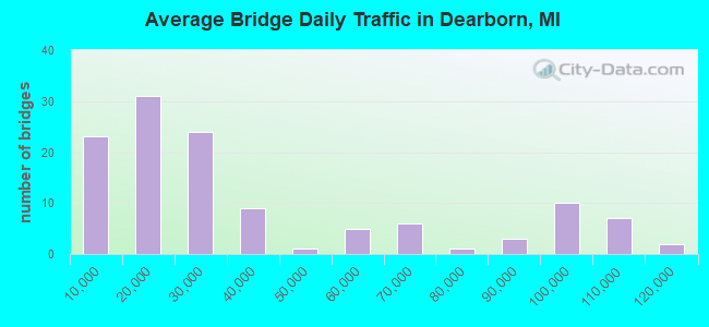
- 4,435,331Total average daily traffic
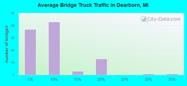
- 319,160Total average daily truck traffic
- National Bridge Inventory (NBI) Registered Bridges for Dearborn
- No street view available for this location
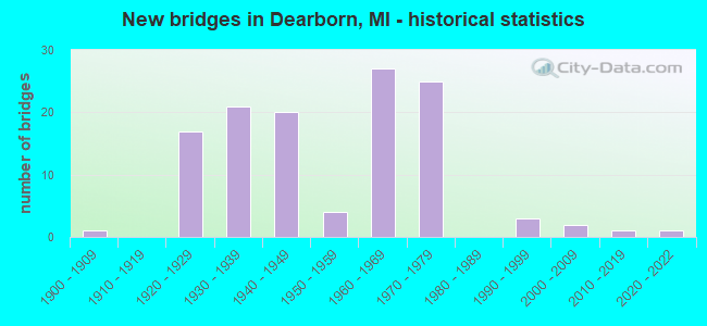
- New bridges - historical statistics
- 11900-1909
- 171920-1929
- 211930-1939
- 201940-1949
- 41950-1959
- 271960-1969
- 251970-1979
- 31990-1999
- 22000-2009
- 12010-2019
- 12020-2022
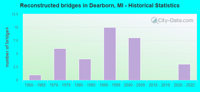
- Reconstructed bridges - Historical Statistics
- 11960-1969
- 61970-1979
- 41980-1989
- 101990-1999
- 82000-2009
- 02010-2019
- 32020-2022
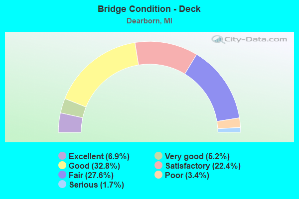
- Bridge Condition - Deck
- 6.9%Excellent
- 5.2%Very good
- 32.8%Good
- 22.4%Satisfactory
- 27.6%Fair
- 3.4%Poor
- 1.7%Serious
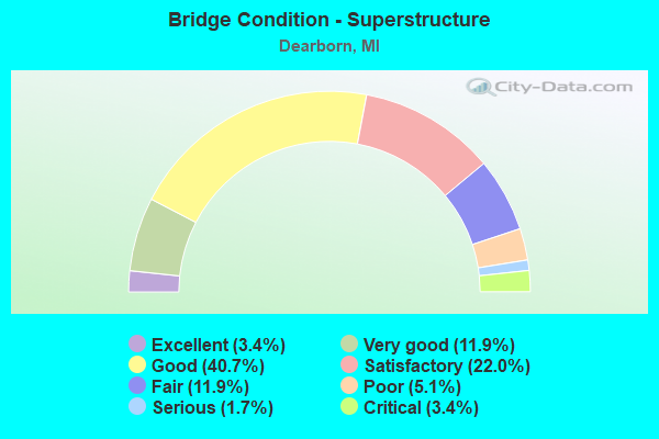
- Bridge Condition - Superstructure
- 3.4%Excellent
- 11.9%Very good
- 40.7%Good
- 22.0%Satisfactory
- 11.9%Fair
- 5.1%Poor
- 1.7%Serious
- 3.4%Critical
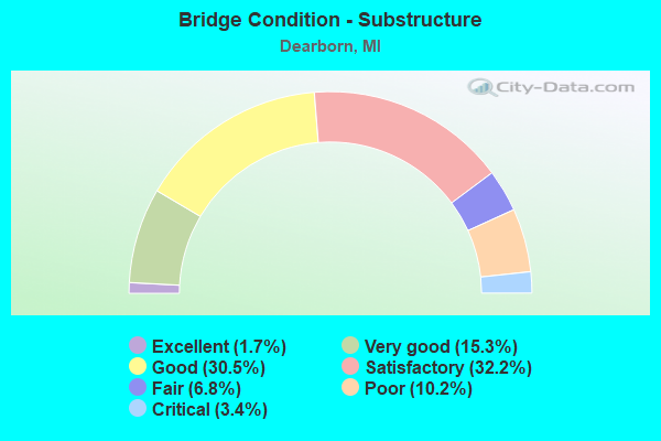
- Bridge Condition - Substructure
- 1.7%Excellent
- 15.3%Very good
- 30.5%Good
- 32.2%Satisfactory
- 6.8%Fair
- 10.2%Poor
- 3.4%Critical
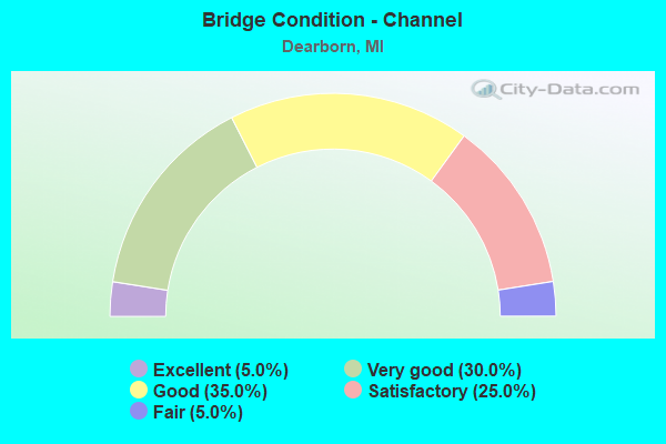
- Bridge Condition - Channel
- 5.0%Excellent
- 30.0%Very good
- 35.0%Good
- 25.0%Satisfactory
- 5.0%Fair
Find on map >> Show street view
Structure Number: 1205, Location: DEARBORN N/I-94 (Lat: 42.305622, Lng: -83.186867), Route carried "under" structure: County highway 2057, Year Built: 1961, Structure Length: 0. m, Average Daily Traffic: 21,821 (year 1997), Truck Traffic: 7%, Features Intersected: ROTUNDA DRIVE, Facility Carried by Structure: GREENFIELD ROAD
Minimum Vertical Clearance: 4.88m (16.01ft), Kilometerpoint: 4.812, Lanes on structure: 10, Lanes under structure: 4, Material/Design: Steel continuous, Design/Construction: Stringer/Multi-beam, Length of Maximum Span: 16.7m (54.8ft)
Find on map >> Show street view
Structure Number: 12051, Location: DEARBORN W/SCHAEFER (Lat: 42.308875, Lng: -83.179758), Route carried "under" structure: County highway 2057, Year Built: 1931, Structure Length: 0. m, Average Daily Traffic: 22,737 (year 1995), Truck Traffic: 5%, Features Intersected: ROTUNDA DRIVE, Facility Carried by Structure: CONRAIL
Minimum Vertical Clearance: 4.47m (14.67ft), Kilometerpoint: 5.530, Lanes under structure: 6, Material/Design: Steel, Design/Construction: Girder and Floorbeam System, Length of Maximum Span: 20.1m (65.9ft)
Find on map >> Show street view
Structure Number: 12052, Location: DEARBORN N/I-94 (Lat: 42.314042, Lng: -83.175606), Route carried "under" structure: City street 2057, Year Built: 1932, Structure Length: 0. m, Average Daily Traffic: 11,663 (year 1992), Truck Traffic: 8%, Features Intersected: SCHAEFER ROAD, Facility Carried by Structure: ROTUNDA DRIVE
Minimum Vertical Clearance: 4.72m (15.49ft), Kilometerpoint: 4.371, Lanes on structure: 4, Lanes under structure: 4, Material/Design: Prestressed concrete, Design/Construction: Stringer/Multi-beam, Length of Maximum Span: 9.4m (30.8ft)
Find on map >> Show street view
Structure Number: 12055, Location: DBN HTS W/ANN ARBOR TRAIL (Lat: 42.341714, Lng: -83.263181), Route carried "under" structure: ServiceCounty highway 14464, Year Built: 1957, Structure Length: 0. m, Average Daily Traffic: 16,370 (year 1996), Features Intersected: E N HINES DRIVE, Facility Carried by Structure: WARREN AVENUE
Minimum Vertical Clearance: 4.39m (14.40ft), Kilometerpoint: 21.925, Lanes on structure: 5, Lanes under structure: 2, Material/Design: Concrete, Design/Construction: Frame, Length of Maximum Span: 20.1m (65.9ft)
Find on map >> Show street view
Structure Number: 12057, Location: DEARBORN E/GREENFIELD (Lat: 42.343764, Lng: -83.188822), Route carried "under" structure: County highway 2057, Year Built: 1928, Structure Length: 0. m, Average Daily Traffic: 38,884 (year 1997), Truck Traffic: 5%, Features Intersected: WARREN AVENUE, Facility Carried by Structure: CSX RR
Minimum Vertical Clearance: 4.45m (14.60ft), Kilometerpoint: 0.615, Lanes under structure: 6, Material/Design: Steel, Design/Construction: Girder and Floorbeam System, Length of Maximum Span: 17.0m (55.8ft)
Find on map >> Show street view
Structure Number: 12058, Location: DRBRN & DETROIT E/WYOMING (Lat: 42.344689, Lng: -83.148425), Route carried "under" structure: County highway 2057, Year Built: 1930, Structure Length: 0. m, Average Daily Traffic: 22,930 (year 1997), Truck Traffic: 5%, Features Intersected: WARREN AVENUE, Facility Carried by Structure: CONRAIL
Minimum Vertical Clearance: 4.42m (14.50ft), Kilometerpoint: 3.945, Lanes under structure: 6, Material/Design: Steel, Design/Construction: Stringer/Multi-beam, Length of Maximum Span: 12.8m (42.0ft)
Find on map >> Show street view
Structure Number: 12193, Location: DEARBORN S/MICHIGAN (Lat: 42.305172, Lng: -83.242200), Route carried "under" structure: County highway 2507, Year Built: 1922, Structure Length: 0. m, Average Daily Traffic: 20,653 (year 1993), Truck Traffic: 5%, Features Intersected: OAKWOOD BLVD, Facility Carried by Structure: MDOT RR CORRIDOR
Minimum Vertical Clearance: 4.11m (13.48ft), Kilometerpoint: 9.149, Lanes under structure: 4, Material/Design: Steel, Design/Construction: Stringer/Multi-beam, Length of Maximum Span: 7.9m (25.9ft)
Find on map >> Show street view
Structure Number: 1223, Location: DEARBORN N/MILLER (Lat: 42.300792, Lng: -83.147644), Route carried "under" structure: County highway 2057, Year Built: 1930, Structure Length: 0. m, Average Daily Traffic: 6,789 (year 1996), Truck Traffic: 8%, Features Intersected: DIX ROAD, Facility Carried by Structure: INDUSTRIAL ROAD
Minimum Vertical Clearance: 4.52m (14.83ft), Kilometerpoint: 2.300, Lanes on structure: 4, Lanes under structure: 6, Material/Design: Steel, Design/Construction: Stringer/Multi-beam, Length of Maximum Span: 12.5m (41.0ft)
Find on map >> Show street view
Structure Number: 12232, Location: AT FORD MOTOR CO GATE 4 (Lat: 42.307453, Lng: -83.155483), Route carried "under" structure: County highway 2057, Year Built: 1942, Structure Length: 0. m, Average Daily Traffic: 9,410 (year 1992), Truck Traffic: 10%, Features Intersected: MILLER ROAD, Facility Carried by Structure: PEDESTRIAN WALKWAY
Minimum Vertical Clearance: 5.03m (16.50ft), Kilometerpoint: 2.261, Lanes under structure: 6, Material/Design: Steel, Design/Construction: Truss - Thru, Length of Maximum Span: 14.0m (45.9ft)
Find on map >> Show street view
Structure Number: 12234, Location: DEARBORN S/I-94 (Lat: 42.298053, Lng: -83.181697), Route carried "under" structure: County highway 10000, Year Built: 1925, Structure Length: 0. m, Average Daily Traffic: 12,400 (year 1997), Truck Traffic: 7%, Features Intersected: GREENFIELD ROAD, Facility Carried by Structure: GTW RR
Minimum Vertical Clearance: 4.49m (14.73ft), Kilometerpoint: 3.209, Lanes under structure: 4, Material/Design: Steel, Design/Construction: Stringer/Multi-beam, Length of Maximum Span: 11.2m (36.7ft)
Find on map >> Show street view
Structure Number: 12235, Location: DEARBORN S/MICHIGAN (Lat: 42.312939, Lng: -83.192383), Route carried "under" structure: County highway 25000, Year Built: 1927, Structure Length: 0. m, Average Daily Traffic: 21,821 (year 1997), Truck Traffic: 5%, Features Intersected: GREENFIELD ROAD, Facility Carried by Structure: CONRAIL
Minimum Vertical Clearance: 4.49m (14.73ft), Kilometerpoint: 5.087, Lanes under structure: 4, Material/Design: Steel, Design/Construction: Stringer/Multi-beam, Length of Maximum Span: 10.3m (33.8ft)
Find on map >> Show street view
Structure Number: 12236, Location: DEARBORN S/FORD (Lat: 42.328647, Lng: -83.168861), Route carried "under" structure: County highway 2057, Year Built: 1931, Structure Length: 0. m, Average Daily Traffic: 12,602 (year 1994), Truck Traffic: 5%, Features Intersected: OAKMAN BLVD, Facility Carried by Structure: CSX RR
Minimum Vertical Clearance: 4.55m (14.93ft), Kilometerpoint: 0.801, Lanes under structure: 6, Material/Design: Steel, Design/Construction: Girder and Floorbeam System, Length of Maximum Span: 21.0m (68.9ft)
Find on map >> Show street view
Structure Number: 12237, Location: DEARBORN S/MICHIGAN (Lat: 42.318214, Lng: -83.157769), Route carried "under" structure: County highway 2057, Year Built: 1925, Structure Length: 0. m, Average Daily Traffic: 12,087 (year 1996), Truck Traffic: 7%, Features Intersected: WYOMING AVENUE, Facility Carried by Structure: SOUTHERN AVENUE
Minimum Vertical Clearance: 4.45m (14.60ft), Kilometerpoint: 1.413, Lanes on structure: 4, Lanes under structure: 4, Material/Design: Steel continuous, Design/Construction: Stringer/Multi-beam, Length of Maximum Span: 9.7m (31.8ft)
Find on map >> Show street view
Structure Number: 1224, Location: DEARBORN N/MICHIGAN (Lat: 42.329667, Lng: -83.166444), Route carried "under" structure: County highway 2057, Year Built: 1940, Structure Length: 0. m, Average Daily Traffic: 53,300 (year 1989), Truck Traffic: 7%, Features Intersected: FORD ROAD, Facility Carried by Structure: MILLER ROAD
Minimum Vertical Clearance: 4.14m (13.58ft), Kilometerpoint: 0.000, Lanes on structure: 4, Lanes under structure: 6, Material/Design: Steel continuous, Design/Construction: Stringer/Multi-beam, Length of Maximum Span: 15.5m (50.9ft)
Find on map >> Show street view
Structure Number: 12241, Location: DEARBORN N/MICHIGAN (Lat: 42.325889, Lng: -83.166261), Route carried "under" structure: County highway 2057, Year Built: 1927, Structure Length: 0. m, Average Daily Traffic: 7,511 (year 1997), Truck Traffic: 5%, Features Intersected: MILLER ROAD, Facility Carried by Structure: CSX RR
Minimum Vertical Clearance: 4.42m (14.50ft), Kilometerpoint: 0.000, Lanes under structure: 4, Material/Design: Steel, Design/Construction: Girder and Floorbeam System, Length of Maximum Span: 17.0m (55.8ft)
Find on map >> Show street view
Structure Number: 12311, Location: IN DEARBORN (Lat: 42.301233, Lng: -83.257936), Route carried "under" structure: City street , Year Built: 1967, Structure Length: 0. m, Average Daily Traffic: 5,600 (year 1980), Features Intersected: NOWLIN RD, Facility Carried by Structure: MDOT RR CORRIDOR
Minimum Vertical Clearance: 4.36m (14.30ft), Kilometerpoint: 0.373, Lanes under structure: 4, Material/Design: Steel, Design/Construction: Stringer/Multi-beam, Length of Maximum Span: 14.6m (47.9ft)
Find on map >> Show street view
Structure Number: 12312, Location: IN DEARBORN (Lat: 42.303086, Lng: -83.250750), Route carried "under" structure: City street , Year Built: 1940, Structure Length: 0. m, Average Daily Traffic: 7,200 (year 1978), Features Intersected: MILITARY RD, Facility Carried by Structure: MDOT RR CORRIDOR
Minimum Vertical Clearance: 4.34m (14.24ft), Kilometerpoint: 0.982, Lanes under structure: 6, Material/Design: Steel, Design/Construction: Stringer/Multi-beam, Length of Maximum Span: 14.0m (45.9ft)
Find on map >> Show street view
Structure Number: 12315, Location: IN DEARBORN (Lat: 42.310567, Lng: -83.155044), Route carried "under" structure: City street , Year Built: 1925, Structure Length: 0. m, Average Daily Traffic: 11,060 (year 2001), Truck Traffic: 12%, Features Intersected: EAGLE RD, Facility Carried by Structure: GRAND TRUNK RR
Minimum Vertical Clearance: 4.52m (14.83ft), Kilometerpoint: 0.208, Lanes under structure: 4, Material/Design: Steel, Design/Construction: Stringer/Multi-beam, Length of Maximum Span: 9.7m (31.8ft)
Find on map >> Show street view
Structure Number: 12316, Location: IN DEARBORN (Lat: 42.310481, Lng: -83.155264), Route carried "under" structure: City street , Year Built: 1925, Structure Length: 0. m, Average Daily Traffic: 11,060 (year 2001), Truck Traffic: 12%, Features Intersected: EAGLE RD, Facility Carried by Structure: CSX RR
Minimum Vertical Clearance: 4.50m (14.76ft), Kilometerpoint: 0.187, Lanes under structure: 4, Material/Design: Steel, Design/Construction: Stringer/Multi-beam, Length of Maximum Span: 9.7m (31.8ft)
Find on map >> Show street view
Structure Number: 12317, Location: IN DEARBORN (Lat: 42.317511, Lng: -83.160614), Route carried "under" structure: City street , Year Built: 1924, Structure Length: 0. m, Average Daily Traffic: 2,600 (year 1982), Features Intersected: SOUTHERN AVENUE, Facility Carried by Structure: GRAND TRUNK RR
Minimum Vertical Clearance: 5.64m (18.50ft), Kilometerpoint: 0.171, Lanes under structure: 4, Material/Design: Steel continuous, Design/Construction: Girder and Floorbeam System, Length of Maximum Span: 33.2m (108.9ft)
Find on map >> Show street view
Structure Number: 12318, Location: IN DEARBORN (Lat: 42.317553, Lng: -83.160336), Route carried "under" structure: City street , Year Built: 1930, Structure Length: 0. m, Average Daily Traffic: 2,600 (year 1982), Features Intersected: SOUTHERN AVENUE, Facility Carried by Structure: C & O RAILROAD (W)
Minimum Vertical Clearance: 5.74m (18.83ft), Kilometerpoint: 0.193, Lanes under structure: 4, Material/Design: Steel continuous, Design/Construction: Truss - Thru, Length of Maximum Span: 33.2m (108.9ft)
Find on map >> Show street view
Structure Number: 12319, Location: IN DEARBORN (Lat: 42.317575, Lng: -83.160183), Route carried "under" structure: City street , Year Built: 1930, Structure Length: 0. m, Average Daily Traffic: 2,600 (year 1982), Features Intersected: SOUTHERN AVENUE, Facility Carried by Structure: C & O RAILROAD(E)
Minimum Vertical Clearance: 5.74m (18.83ft), Kilometerpoint: 0.208, Lanes under structure: 4, Material/Design: Steel continuous, Design/Construction: Truss - Thru, Length of Maximum Span: 33.2m (108.9ft)
Find on map >> Show street view
Structure Number: 1232, Location: IN DEARBORN (Lat: 42.341992, Lng: -83.186483), Route carried "under" structure: City street , Year Built: 1900, Structure Length: 0. m, Average Daily Traffic: 9,600 (year 1981), Features Intersected: CHASE RD, Facility Carried by Structure: C&O RAILROAD
Minimum Vertical Clearance: 4.59m (15.06ft), Kilometerpoint: 2.509, Lanes under structure: 4, Material/Design: Steel, Design/Construction: Stringer/Multi-beam, Length of Maximum Span: 21.6m (70.9ft)
Find on map >> Show street view
Structure Number: 12322, Location: IN DEARBORN (Lat: 42.334386, Lng: -83.176425), Route carried "under" structure: City street 2057, Year Built: 1925, Structure Length: 0. m, Average Daily Traffic: 15,800 (year 1982), Features Intersected: SCHAEFER ROAD, Facility Carried by Structure: GRAND TRUNK RR
Minimum Vertical Clearance: 4.34m (14.24ft), Kilometerpoint: 6.632, Lanes under structure: 4, Material/Design: Steel, Design/Construction: Girder and Floorbeam System, Length of Maximum Span: 16.7m (54.8ft)
Find on map >> Show street view
Structure Number: 12323, Location: IN DEARBORN (Lat: 42.315117, Lng: -83.175653), Route carried "under" structure: City street 2057, Year Built: 1924, Structure Length: 0. m, Average Daily Traffic: 15,800 (year 1982), Features Intersected: SCHAEFER ROAD, Facility Carried by Structure: CONRAIL RR
Minimum Vertical Clearance: 4.36m (14.30ft), Kilometerpoint: 4.519, Lanes under structure: 4, Material/Design: Steel, Design/Construction: Girder and Floorbeam System, Length of Maximum Span: 9.4m (30.8ft)