Bridge Statistics for Decatur, Alabama (AL)
Condition, Traffic, Stress, Structural Evaluation, Project Costs
- National Bridge Inventory (NBI) Statistics
- 115Number of bridges
- 3,763ft / 1,147mTotal length
- $417,653,000Total costs
- 1,430,724Total average daily traffic
- 205,848Total average daily truck traffic
- National Bridge Inventory (NBI) Registered Bridges for Decatur
- No street view available for this location
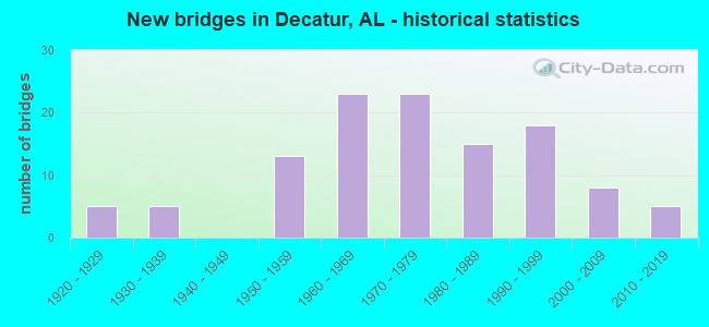
- New bridges - historical statistics
- 51920-1929
- 51930-1939
- 131950-1959
- 231960-1969
- 231970-1979
- 151980-1989
- 181990-1999
- 82000-2009
- 52010-2019
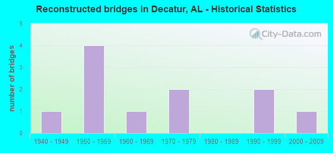
- Reconstructed bridges - Historical Statistics
- 11940-1949
- 41950-1959
- 11960-1969
- 21970-1979
- 01980-1989
- 21990-1999
- 12000-2009
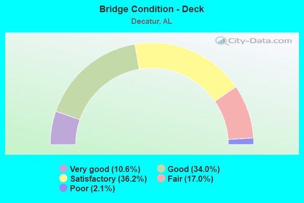
- Bridge Condition - Deck
- 10.6%Very good
- 34.0%Good
- 36.2%Satisfactory
- 17.0%Fair
- 2.1%Poor
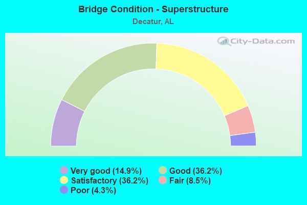
- Bridge Condition - Superstructure
- 14.9%Very good
- 36.2%Good
- 36.2%Satisfactory
- 8.5%Fair
- 4.3%Poor
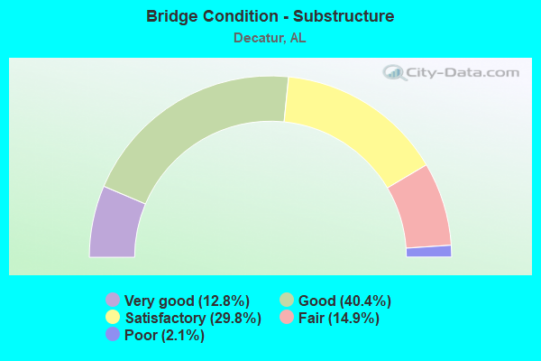
- Bridge Condition - Substructure
- 12.8%Very good
- 40.4%Good
- 29.8%Satisfactory
- 14.9%Fair
- 2.1%Poor
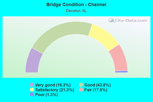
- Bridge Condition - Channel
- 16.3%Very good
- 43.8%Good
- 21.3%Satisfactory
- 17.5%Fair
- 1.3%Poor
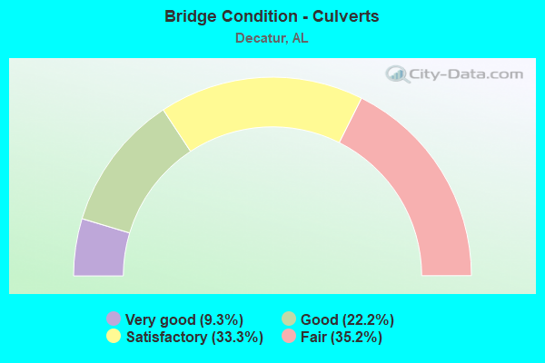
- Bridge Condition - Culverts
- 9.3%Very good
- 22.2%Good
- 33.3%Satisfactory
- 35.2%Fair
Find on map >> Show street view
Structure Number: 15675, Location: JCT MAGNOLIA * BRUSH CK (Lat: 34.578200, Lng: -86.973500), Route carried "on" structure: City street , Year Built: 1987, Status: Open, Structure Length: 0.73m (2.40ft), Average Daily Traffic: 4,176 (year 2009), Truck Traffic: 20%, Average Future Daily Traffic: 4,177 (year 2030), Design Load: H 15, Features Intersected: BRUSH CREEK, Facility Carried by Structure: MAGNOLIA STREET
Minimum Vertical Clearance: 7.56m (24.80ft), Kilometerpoint: 0.010, Lanes on structure: 2, Owner: City or Municipal Highway Agency, Approaching Roadway Width: 11.0m (36.1ft), Material/Design: Concrete, Design/Construction: Culvert, Number Of Spans In Main Unit: 2, Length of Maximum Span: 3.7m (12.1ft), Curb-To-Curb Width: 7.8m (25.6ft), Out-to-Out Width: 26.6m (87.3ft)
Condition: Channel: Good, Culverts: Fair, Operating Rating: 88.9 metric tons, Method Used To Determine Operating Rating: Load Factor (LF), Inventory Rating: 57.8 metric tons, Method Used To Determine Inventory Rating: Load Factor (LF), Structural Evaluation: Somewhat better than minimum adequacy, Deck Geometry: High priority of replacement, Waterway Adequacy: Equal to present minimum criteria, Approach Roadway Alignment: Equal to present minimum criteria, Length Of Structure Improvement: 1.38m (4.53ft), Designated Inspection Frequency: Every 24 months, Inspection Date: August 2021, Bridge Improvement Cost: $692,000, Roadway Improvement Cost: $69,000, Total Project Cost: $761,000 ( Estimate for 2022), Deck Structure Type: Concrete Cast-file-Place, Wearing Surface/Protective System: Wearing Surface: Bituminous
Find on map >> Show street view
Structure Number: 15677, Location: JCT FAIRGRD RD*CLARKS SPG (Lat: 34.559300, Lng: -87.007000), Route carried "on" structure: City street , Year Built: 1989, Status: Open, Structure Length: 1.52m (4.99ft), Average Daily Traffic: 9,753 (year 2009), Truck Traffic: 20%, Average Future Daily Traffic: 6,017 (year 2030), Design Load: H 10, Features Intersected: CLARKS SPRINGS, Facility Carried by Structure: FAIRGROUND ROAD S
Minimum Vertical Clearance: 30+ m (98+ ft), Kilometerpoint: 0.010, Lanes on structure: 2, Owner: City or Municipal Highway Agency, Approaching Roadway Width: 12.2m (40.0ft), Material/Design: Concrete, Design/Construction: Culvert, Number Of Spans In Main Unit: 4, Length of Maximum Span: 3.4m (11.2ft), Curb or Sidewalk Widths: Left: 0.2m (0.7ft), Right: 0.2m (0.7ft), Curb-To-Curb Width: 12.2m (40.0ft), Out-to-Out Width: 18.2m (59.7ft)
Condition: Channel: Satisfactory, Culverts: Satisfactory, Operating Rating: 54.6 metric tons, Method Used To Determine Operating Rating: Load Factor (LF), Inventory Rating: 32.7 metric tons, Method Used To Determine Inventory Rating: Load Factor (LF), Structural Evaluation: Equal to present minimum criteria, Deck Geometry: Somewhat better than minimum adequacy, Waterway Adequacy: Equal to present minimum criteria, Approach Roadway Alignment: Better than present minimum criteria, Length Of Structure Improvement: 2.20m (7.22ft), Designated Inspection Frequency: Every 24 months, Inspection Date: September 2021, Bridge Improvement Cost: $775,000, Roadway Improvement Cost: $78,000, Total Project Cost: $853,000 ( Estimate for 2022), Deck Structure Type: Concrete Cast-file-Place, Wearing Surface/Protective System: Wearing Surface: Bituminous
Find on map >> Show street view
Structure Number: 16284, Location: JCT BETTY ST * DRY BRANCH (Lat: 34.578400, Lng: -87.013800), Route carried "on" structure: City street , Year Built: 1995, Status: Open, Structure Length: 0.79m (2.59ft), Average Daily Traffic: 6,920 (year 2005), Truck Traffic: 15%, Average Future Daily Traffic: 9,115 (year 2028), Design Load: HS 20, Features Intersected: BETTY ST SW * DRY BRANCH, Facility Carried by Structure: BETTY ST SW
Minimum Vertical Clearance: 30+ m (98+ ft), Kilometerpoint: 0.010, Lanes on structure: 2, Owner: City or Municipal Highway Agency, Approaching Roadway Width: 11.0m (36.1ft), Material/Design: Concrete, Design/Construction: Culvert, Number Of Spans In Main Unit: 5, Length of Maximum Span: 1.2m (3.9ft), Curb or Sidewalk Widths: Left: 0.1m (0.3ft), Right: 0.1m (0.3ft), Curb-To-Curb Width: 11.0m (36.1ft), Out-to-Out Width: 14.2m (46.6ft)
Condition: Channel: Good, Culverts: Satisfactory, Operating Rating: 43.5 metric tons, Method Used To Determine Operating Rating: Field evaluation and documented engineering judgment, Inventory Rating: 32.7 metric tons, Method Used To Determine Inventory Rating: Field evaluation and documented engineering judgment, Structural Evaluation: Equal to present minimum criteria, Deck Geometry: Meets minimum limits, Waterway Adequacy: Somewhat better than minimum adequacy, Approach Roadway Alignment: Equal to present desirable criteria, Length Of Structure Improvement: 1.44m (4.72ft), Designated Inspection Frequency: Every 24 months, Inspection Date: July 2021, Bridge Improvement Cost: $300,000, Roadway Improvement Cost: $30,000, Total Project Cost: $330,000 ( Estimate for 2022), Wearing Surface/Protective System: Wearing Surface: Bituminous
Find on map >> Show street view
Structure Number: 1631, Location: 1 M N JCT SR 3 & SR 20 (Lat: 34.619369, Lng: -86.966181), Route carried "on" structure: US 31, Year Built: 1997, Status: Open, Structure Length: 11.43m (37.50ft), Average Daily Traffic: 25,465 (year 2021), Truck Traffic: 7%, Average Future Daily Traffic: 32,711 (year 2033), Design Load: HS 20, Features Intersected: Tennessee River Relief, Facility Carried by Structure: SR 3
Minimum Vertical Clearance: 7.56m (24.80ft), Kilometerpoint: 578.059, Lanes on structure: 2, Base Highway Network: Yes, Owner: State Highway Agency, Approaching Roadway Width: 12.5m (41.0ft), Skew: 10 degrees, Material/Design: Prestressed concrete continuous, Design/Construction: Stringer/Multi-beam, Number Of Spans In Main Unit: 6, Length of Maximum Span: 18.9m (62.0ft), Curb-To-Curb Width: 12.2m (40.0ft), Out-to-Out Width: 13.0m (42.7ft)
Condition: Deck: Good, Superstructure: Good, Substructure: Good, Channel: Very good, Operating Rating: 51.8 metric tons, Method Used To Determine Operating Rating: Load Factor (LF), Inventory Rating: 30.7 metric tons, Method Used To Determine Inventory Rating: Load Factor (LF), Structural Evaluation: Better than present minimum criteria, Deck Geometry: Better than present minimum criteria, Waterway Adequacy: Equal to present desirable criteria, Approach Roadway Alignment: Equal to present desirable criteria, Length Of Structure Improvement: 12.30m (40.35ft), Designated Inspection Frequency: Every 24 months, Underwater Inspection Frequency: Every 24 months, Inspection Date: May 2021, Underwater Inspection Date: July 2021, Bridge Improvement Cost: $3,543,000, Roadway Improvement Cost: $354,000, Total Project Cost: $3,897,000 ( Estimate for 2022), Deck Structure Type: Concrete Cast-file-Place
Find on map >> Show street view
Structure Number: 16311, Location: 1 M N JCT SR 3 & SR 20 (Lat: 34.619194, Lng: -86.965956), Route carried "on" structure: US 31, Year Built: 1995, Status: Open, Structure Length: 11.43m (37.50ft), Average Daily Traffic: 25,465 (year 2021), Truck Traffic: 7%, Average Future Daily Traffic: 32,711 (year 2033), Design Load: HS 20, Features Intersected: Tennessee River Relief, Facility Carried by Structure: SR 3
Minimum Vertical Clearance: 30+ m (98+ ft), Kilometerpoint: 578.059, Lanes on structure: 2, Base Highway Network: Yes, Owner: State Highway Agency, Approaching Roadway Width: 12.2m (40.0ft), Skew: 10 degrees, Material/Design: Prestressed concrete continuous, Design/Construction: Stringer/Multi-beam, Number Of Spans In Main Unit: 6, Length of Maximum Span: 18.9m (62.0ft), Curb-To-Curb Width: 12.2m (40.0ft), Out-to-Out Width: 13.1m (43.0ft)
Condition: Deck: Good, Superstructure: Good, Substructure: Very good, Channel: Very good, Operating Rating: 51.8 metric tons, Method Used To Determine Operating Rating: Load Factor (LF), Inventory Rating: 30.7 metric tons, Method Used To Determine Inventory Rating: Load Factor (LF), Structural Evaluation: Better than present minimum criteria, Deck Geometry: Better than present minimum criteria, Waterway Adequacy: Equal to present desirable criteria, Approach Roadway Alignment: Equal to present desirable criteria, Length Of Structure Improvement: 12.30m (40.35ft), Designated Inspection Frequency: Every 24 months, Underwater Inspection Frequency: Every 24 months, Inspection Date: May 2021, Underwater Inspection Date: July 2021, Bridge Improvement Cost: $3,628,000, Roadway Improvement Cost: $363,000, Total Project Cost: $3,991,000 ( Estimate for 2022), Deck Structure Type: Concrete Cast-file-Place
Find on map >> Show street view
Structure Number: 16368, Location: 0.1 M N JCT SR 3 & SR 20 (Lat: 34.611072, Lng: -86.974731), Route carried "on" structure: US 31, Year Built: 1996, Status: Open, Structure Length: 79.10m (259.51ft), Average Daily Traffic: 20,045 (year 2021), Truck Traffic: 7%, Average Future Daily Traffic: 25,749 (year 2033), Design Load: HS 20, Features Intersected: TN River & CSX RR, Facility Carried by Structure: SR 3
Minimum Vertical Clearance: 30+ m (98+ ft), Kilometerpoint: 576.974, Lanes on structure: 3, Lanes under structure: 2, Base Highway Network: Yes, Owner: State Highway Agency, Approaching Roadway Width: 12.2m (40.0ft), Skew: 10 degrees, Navigation Control: Yes ( Vertical Clearance: 17.4m (57.1ft), Horizontal Clearance: 106.7m (350.1ft)), Material/Design: Steel continuous, Design/Construction: Stringer/Multi-beam, Number Of Spans In Main Unit: 1, Number Of Approach Spans: 13, Length of Maximum Span: 109.7m (359.9ft), Curb-To-Curb Width: 12.2m (40.0ft), Out-to-Out Width: 13.1m (43.0ft)
Condition: Deck: Good, Superstructure: Good, Substructure: Good, Channel: Very good, Operating Rating: 50.7 metric tons, Method Used To Determine Operating Rating: Load Factor (LF), Inventory Rating: 33.0 metric tons, Method Used To Determine Inventory Rating: Load Factor (LF), Structural Evaluation: Better than present minimum criteria, Deck Geometry: Meets minimum limits, Underclear: Somewhat better than minimum adequacy, Waterway Adequacy: Equal to present desirable criteria, Approach Roadway Alignment: Equal to present desirable criteria, Length Of Structure Improvement: 79.10m (259.51ft), Designated Inspection Frequency: Every 24 months, Underwater Inspection Frequency: Every 24 months, Inspection Date: May 2021, Underwater Inspection Date: July 2021, Bridge Improvement Cost: $23,322,000, Roadway Improvement Cost: $2,332,000, Total Project Cost: $25,654,000 ( Estimate for 2022), Deck Structure Type: Concrete Cast-file-Place
Find on map >> Show street view
Structure Number: 17334, Location: 0.5MI WEST OF NEEL (Lat: 34.462889, Lng: -87.067742), Route carried "on" structure: County highway 4, Year Built: 1999, Status: Open, Structure Length: 0.94m (3.08ft), Average Daily Traffic: 2,400 (year 1998), Truck Traffic: 2%, Average Future Daily Traffic: 5,517 (year 2040), Design Load: HS 20, Features Intersected: NEEL CREEK
Minimum Vertical Clearance: 0.00m, Kilometerpoint: 0.000, Lanes on structure: 2, Owner: County Highway Agency, Approaching Roadway Width: 12.2m (40.0ft), Material/Design: Concrete, Design/Construction: Culvert, Number Of Spans In Main Unit: 3, Length of Maximum Span: 3.0m (9.8ft), Curb-To-Curb Width: 12.6m (41.3ft), Out-to-Out Width: 13.4m (44.0ft)
Condition: Channel: Very good, Culverts: Very good, Operating Rating: 88.9 metric tons, Method Used To Determine Operating Rating: Load Factor (LF), Inventory Rating: 65.2 metric tons, Method Used To Determine Inventory Rating: Load Factor (LF), Structural Evaluation: Equal to present desirable criteria, Deck Geometry: Equal to present minimum criteria, Waterway Adequacy: Equal to present desirable criteria, Approach Roadway Alignment: Equal to present desirable criteria, Length Of Structure Improvement: 1.61m (5.28ft), Designated Inspection Frequency: Every 24 months, Inspection Date: October 2020, Bridge Improvement Cost: $409,000, Roadway Improvement Cost: $41,000, Total Project Cost: $450,000 ( Estimate for 2022)
Find on map >> Show street view
Structure Number: 17336, Location: 1.2 KM.OF HWY.72 WEST (Lat: 34.634400, Lng: -87.094900), Route carried "on" structure: Business City street , Year Built: 1996, Status: Open, Structure Length: 1.08m (3.54ft), Average Daily Traffic: 741 (year 2005), Truck Traffic: 25%, Average Future Daily Traffic: 780 (year 2030), Design Load: HS 20, Features Intersected: TRICO.BLVD./CREEK, Facility Carried by Structure: TRICO.BLVD.
Minimum Vertical Clearance: 7.56m (24.80ft), Kilometerpoint: 0.010, Lanes on structure: 4, Owner: City or Municipal Highway Agency, Approaching Roadway Width: 21.0m (68.9ft), Skew: 2 degrees, Material/Design: Concrete, Design/Construction: Culvert, Number Of Spans In Main Unit: 2, Length of Maximum Span: 5.2m (17.1ft), Curb-To-Curb Width: 21.2m (69.6ft), Out-to-Out Width: 59.1m (193.9ft)
Condition: Channel: Fair, Culverts: Fair, Operating Rating: 88.9 metric tons, Method Used To Determine Operating Rating: Load Factor (LF), Inventory Rating: 67.3 metric tons, Method Used To Determine Inventory Rating: Load Factor (LF), Structural Evaluation: Somewhat better than minimum adequacy, Deck Geometry: Superior to present desirable criteria, Waterway Adequacy: Somewhat better than minimum adequacy, Approach Roadway Alignment: Superior to present desirable criteria, Length Of Structure Improvement: 1.75m (5.74ft), Designated Inspection Frequency: Every 24 months, Inspection Date: August 2021, Bridge Improvement Cost: $1,952,000, Roadway Improvement Cost: $195,000, Total Project Cost: $2,147,000 ( Estimate for 2022), Deck Structure Type: Concrete Precast Panels, Wearing Surface/Protective System: Wearing Surface: Bituminous
Find on map >> Show street view
Structure Number: 17337, Location: JCT.BASSETT AVE/CLARK SPG (Lat: 34.572778, Lng: -86.966667), Route carried "on" structure: Bypass City street , Year Built: 1996, Status: Open, Structure Length: 2.73m (8.96ft), Average Daily Traffic: 854 (year 2007), Truck Traffic: 25%, Average Future Daily Traffic: 1,560 (year 2033), Design Load: HS 20, Features Intersected: BASSETT AVE./CLARK SPGS., Facility Carried by Structure: BASSETT AVE.
Minimum Vertical Clearance: 0.00m, Kilometerpoint: 0.010, Lanes on structure: 2, Owner: City or Municipal Highway Agency, Approaching Roadway Width: 12.5m (41.0ft), Skew: 1 degrees, Material/Design: Concrete, Design/Construction: Culvert, Number Of Spans In Main Unit: 5, Length of Maximum Span: 27.0m (88.6ft), Curb or Sidewalk Widths: Left: 27.0m (88.6ft), Right: 26.4m (86.6ft), Curb-To-Curb Width: 12.2m (40.0ft), Out-to-Out Width: 12.5m (41.0ft)
Condition: Channel: Good, Culverts: Fair, Operating Rating: 48.4 metric tons, Method Used To Determine Operating Rating: Load Factor (LF), Inventory Rating: 29.0 metric tons, Method Used To Determine Inventory Rating: Load Factor (LF), Structural Evaluation: Somewhat better than minimum adequacy, Deck Geometry: High priority of corrective action, Waterway Adequacy: Equal to present minimum criteria, Approach Roadway Alignment: Equal to present desirable criteria, Length Of Structure Improvement: 3.65m (11.98ft), Designated Inspection Frequency: Every 24 months, Inspection Date: June 2021, Bridge Improvement Cost: $885,000, Roadway Improvement Cost: $89,000, Total Project Cost: $974,000 ( Estimate for 2022), Deck Structure Type: Concrete Cast-file-Place
Find on map >> Show street view
Structure Number: 1742, Location: .4 KM. WEST OF SPRING AVE (Lat: 34.558983, Lng: -87.004975), Route carried "on" structure: Business City street 5, Year Built: 1998, Status: Open, Structure Length: 1.40m (4.59ft), Average Daily Traffic: 764 (year 2005), Truck Traffic: 10%, Average Future Daily Traffic: 624 (year 2028), Design Load: HS 20, Features Intersected: WIMBERLY DR./BRUSH CREEK, Facility Carried by Structure: WIMBERLY DR.
Minimum Vertical Clearance: 0.00m, Kilometerpoint: 0.000, Lanes on structure: 2, Owner: City or Municipal Highway Agency, Approaching Roadway Width: 8.7m (28.5ft), Skew: 2 degrees, Material/Design: Concrete, Design/Construction: Culvert, Number Of Spans In Main Unit: 3, Length of Maximum Span: 4.7m (15.4ft), Curb or Sidewalk Widths: Left: 14.0m (45.9ft), Right: 14.0m (45.9ft), Curb-To-Curb Width: 8.7m (28.5ft), Out-to-Out Width: 8.7m (28.5ft)
Condition: Channel: Satisfactory, Culverts: Good, Operating Rating: 84.9 metric tons, Method Used To Determine Operating Rating: Load Factor (LF), Inventory Rating: 51.0 metric tons, Method Used To Determine Inventory Rating: Load Factor (LF), Structural Evaluation: Better than present minimum criteria, Deck Geometry: High priority of corrective action, Waterway Adequacy: Equal to present minimum criteria, Approach Roadway Alignment: Equal to present desirable criteria, Length Of Structure Improvement: 2.07m (6.79ft), Designated Inspection Frequency: Every 24 months, Inspection Date: June 2021, Bridge Improvement Cost: $1,401,000, Roadway Improvement Cost: $140,000, Total Project Cost: $1,541,000 ( Estimate for 2022), Deck Structure Type: Concrete Cast-file-Place, Wearing Surface/Protective System: Wearing Surface: Bituminous
Find on map >> Show street view
Structure Number: 17586, Location: 1.5 M N JCT SR 67 & SR 3 (Lat: 34.559739, Lng: -87.000022), Route carried "on" structure: Business State highway 67, Year Built: 1965, Year Reconstructed: 2001, Status: Open, Structure Length: 1.16m (3.81ft), Average Daily Traffic: 31,030 (year 2021), Truck Traffic: 6%, Average Future Daily Traffic: 40,256 (year 2033), Design Load: HS 20, Features Intersected: CLARK SPRING, Facility Carried by Structure: SPRING AVENUE
Minimum Vertical Clearance: 7.56m (24.80ft), Kilometerpoint: 65.098, Lanes on structure: 5, Base Highway Network: Yes, Owner: State Highway Agency, Approaching Roadway Width: 18.3m (60.0ft), Material/Design: Concrete, Design/Construction: Culvert, Number Of Spans In Main Unit: 3, Length of Maximum Span: 3.7m (12.1ft)
Condition: Channel: Very good, Culverts: Good, Operating Rating: 58.5 metric tons, Method Used To Determine Operating Rating: Load Factor (LF), Inventory Rating: 35.1 metric tons, Method Used To Determine Inventory Rating: Load Factor (LF), Structural Evaluation: Better than present minimum criteria, Waterway Adequacy: Better than present minimum criteria, Approach Roadway Alignment: Better than present minimum criteria, Length Of Structure Improvement: 1.84m (6.04ft), Designated Inspection Frequency: Every 24 months, Inspection Date: October 2021, Bridge Improvement Cost: $1,474,000, Roadway Improvement Cost: $147,000, Total Project Cost: $1,621,000 ( Estimate for 2022)
Find on map >> Show street view
Structure Number: 17593, Location: 2.35MI NORTH OF OAK RIDGE (Lat: 34.503842, Lng: -86.984550), Route carried "on" structure: County highway 106, Year Built: 2000, Status: Open, Structure Length: 4.15m (13.62ft), Average Daily Traffic: 1,375 (year 2004), Truck Traffic: 3%, Average Future Daily Traffic: 2,754 (year 2040), Design Load: HS 20, Features Intersected: FLINT CREEK RELIEF, Facility Carried by Structure: NORRIS MILL ROAD
Minimum Vertical Clearance: 6.00m (19.69ft), Kilometerpoint: 0.000, Lanes on structure: 2, Owner: County Highway Agency, Approaching Roadway Width: 8.5m (27.9ft), Material/Design: Concrete, Design/Construction: Channel Beam, Number Of Spans In Main Unit: 4, Length of Maximum Span: 10.4m (34.1ft), Curb or Sidewalk Widths: Left: 0.3m (1.0ft), Right: 0.3m (1.0ft), Curb-To-Curb Width: 8.5m (27.9ft), Out-to-Out Width: 9.1m (29.9ft)
Condition: Deck: Good, Superstructure: Good, Substructure: Very good, Channel: Fair, Operating Rating: 71.7 metric tons, Method Used To Determine Operating Rating: Load Factor (LF), Inventory Rating: 43.0 metric tons, Method Used To Determine Inventory Rating: Load Factor (LF), Structural Evaluation: Better than present minimum criteria, Deck Geometry: Somewhat better than minimum adequacy, Waterway Adequacy: Somewhat better than minimum adequacy, Approach Roadway Alignment: Equal to present desirable criteria, Length Of Structure Improvement: 5.12m (16.80ft), Designated Inspection Frequency: Every 24 months, Inspection Date: March 2020, Bridge Improvement Cost: $1,018,000, Roadway Improvement Cost: $102,000, Total Project Cost: $1,120,000 ( Estimate for 2022), Deck Structure Type: Concrete Precast Panels
Find on map >> Show street view
Structure Number: 17756, Location: 0.1 MI WEST SR24 (Lat: 34.598464, Lng: -87.047569), Route carried "on" structure: County highway 420, Year Built: 1952, Status: Open, Structure Length: 1.52m (4.99ft), Average Daily Traffic: 4,500 (year 1999), Truck Traffic: 8%, Average Future Daily Traffic: 8,933 (year 2041), Design Load: H 15, Features Intersected: BAKERS CREEK, Facility Carried by Structure: OLD HWY 24
Minimum Vertical Clearance: 10.00m (32.81ft), Kilometerpoint: 0.000, Lanes on structure: 2, Owner: County Highway Agency, Approaching Roadway Width: 7.3m (24.0ft), Material/Design: Concrete, Design/Construction: Culvert, Number Of Spans In Main Unit: 4, Length of Maximum Span: 3.7m (12.1ft)
Condition: Channel: Very good, Culverts: Satisfactory, Operating Rating: 64.1 metric tons, Method Used To Determine Operating Rating: Load Factor (LF), Inventory Rating: 38.5 metric tons, Method Used To Determine Inventory Rating: Load Factor (LF), Structural Evaluation: Equal to present minimum criteria, Waterway Adequacy: Equal to present desirable criteria, Approach Roadway Alignment: Better than present minimum criteria, Length Of Structure Improvement: 2.20m (7.22ft), Designated Inspection Frequency: Every 24 months, Inspection Date: January 2021, Bridge Improvement Cost: $648,000, Roadway Improvement Cost: $65,000, Total Project Cost: $713,000 ( Estimate for 2022)
Find on map >> Show street view
Structure Number: 17997, Location: 2.0 MI NE COUNTY LINE (Lat: 34.531717, Lng: -87.081067), Route carried "on" structure: County highway 1087, Year Built: 2001, Status: Open, Structure Length: 2.05m (6.73ft), Average Daily Traffic: 4,050 (year 2008), Truck Traffic: 5%, Average Future Daily Traffic: 7,939 (year 2042), Design Load: HS 20, Features Intersected: MUD TAVERN CREEK, Facility Carried by Structure: OLD MOULTON ROAD
Minimum Vertical Clearance: 9.14m (29.99ft), Kilometerpoint: 0.000, Lanes on structure: 2, Owner: County Highway Agency, Approaching Roadway Width: 12.2m (40.0ft), Skew: 3 degrees, Material/Design: Concrete, Design/Construction: Culvert, Number Of Spans In Main Unit: 4, Length of Maximum Span: 4.9m (16.1ft), Curb-To-Curb Width: 12.8m (42.0ft), Out-to-Out Width: 13.4m (44.0ft)
Condition: Channel: Good, Culverts: Very good, Operating Rating: 85.1 metric tons, Method Used To Determine Operating Rating: Load Factor (LF), Inventory Rating: 51.1 metric tons, Method Used To Determine Inventory Rating: Load Factor (LF), Structural Evaluation: Equal to present desirable criteria, Deck Geometry: Equal to present minimum criteria, Waterway Adequacy: Equal to present desirable criteria, Approach Roadway Alignment: Equal to present desirable criteria, Length Of Structure Improvement: 2.82m (9.25ft), Designated Inspection Frequency: Every 24 months, Inspection Date: Febuary 2022, Bridge Improvement Cost: $829,000, Roadway Improvement Cost: $83,000, Total Project Cost: $912,000 ( Estimate for 2022)
Find on map >> Show street view
Structure Number: 18791, Location: 1 MI SOUTH SR 67 (Lat: 34.533992, Lng: -86.921064), Route carried "on" structure: County highway 1242, Year Built: 2004, Status: Open, Structure Length: 1.47m (4.82ft), Average Daily Traffic: 50 (year 2004), Truck Traffic: 2%, Average Future Daily Traffic: 102 (year 2040), Design Load: HS 20, Features Intersected: TRIB OF FLINT CREEK, Facility Carried by Structure: RURAL GROVE ROAD
Minimum Vertical Clearance: 30+ m (98+ ft), Kilometerpoint: 0.000, Lanes on structure: 2, Owner: County Highway Agency, Approaching Roadway Width: 6.7m (22.0ft), Skew: 3 degrees, Material/Design: Concrete, Design/Construction: Culvert, Number Of Spans In Main Unit: 4, Length of Maximum Span: 3.5m (11.5ft), Curb or Sidewalk Widths: Left: 0.2m (0.7ft), Right: 0.2m (0.7ft), Curb-To-Curb Width: 12.9m (42.3ft), Out-to-Out Width: 13.5m (44.3ft)
Condition: Channel: Very good, Culverts: Very good, Operating Rating: 63.1 metric tons, Method Used To Determine Operating Rating: Load Factor (LF), Inventory Rating: 37.8 metric tons, Method Used To Determine Inventory Rating: Load Factor (LF), Structural Evaluation: Equal to present desirable criteria, Deck Geometry: Superior to present desirable criteria, Waterway Adequacy: Better than present minimum criteria, Approach Roadway Alignment: Equal to present desirable criteria, Length Of Structure Improvement: 2.15m (7.05ft), Designated Inspection Frequency: Every 24 months, Inspection Date: October 2020, Bridge Improvement Cost: $632,000, Roadway Improvement Cost: $63,000, Total Project Cost: $695,000 ( Estimate for 2022)
Find on map >> Show street view
Structure Number: 18802, Location: 3.5 MI EAST OF CO. LINE (Lat: 34.604958, Lng: -87.045994), Route carried "on" structure: County highway 1220, Year Built: 2003, Status: Open, Structure Length: 5.18m (16.99ft), Average Daily Traffic: 1,033 (year 2000), Average Future Daily Traffic: 2,235 (year 2039), Design Load: HS 20, Features Intersected: BAKERS CREEK, Facility Carried by Structure: OLD TRINITY ROAD
Minimum Vertical Clearance: 12.19m (39.99ft), Kilometerpoint: 0.000, Lanes on structure: 2, Owner: County Highway Agency, Approaching Roadway Width: 6.7m (22.0ft), Material/Design: Concrete, Design/Construction: Channel Beam, Number Of Spans In Main Unit: 5, Length of Maximum Span: 10.4m (34.1ft), Curb or Sidewalk Widths: Left: 0.4m (1.3ft), Right: 0.4m (1.3ft), Curb-To-Curb Width: 8.5m (27.9ft), Out-to-Out Width: 9.3m (30.5ft)
Condition: Deck: Good, Superstructure: Good, Substructure: Good, Channel: Very good, Operating Rating: 75.6 metric tons, Method Used To Determine Operating Rating: Load Factor (LF), Inventory Rating: 45.4 metric tons, Method Used To Determine Inventory Rating: Load Factor (LF), Structural Evaluation: Better than present minimum criteria, Deck Geometry: Somewhat better than minimum adequacy, Waterway Adequacy: Equal to present desirable criteria, Approach Roadway Alignment: Equal to present desirable criteria, Length Of Structure Improvement: 6.21m (20.37ft), Designated Inspection Frequency: Every 24 months, Inspection Date: September 2021, Bridge Improvement Cost: $1,277,000, Roadway Improvement Cost: $128,000, Total Project Cost: $1,405,000 ( Estimate for 2022), Deck Structure Type: Concrete Precast Panels
Find on map >> Show street view
Structure Number: 18979, Location: 600 FT N. POOLE VALLEY RD (Lat: 34.534200, Lng: -86.982800), Route carried "on" structure: Bypass City street , Year Built: 2002, Status: Open, Structure Length: 1.16m (3.81ft), Average Daily Traffic: 399 (year 2005), Truck Traffic: 25%, Average Future Daily Traffic: 455 (year 2028), Features Intersected: CENTRAL PARKWAY/DITCH, Facility Carried by Structure: CENTRAL PARKWAY
Minimum Vertical Clearance: 30.45m (99.90ft), Kilometerpoint: 0.016, Lanes on structure: 2, Owner: City or Municipal Highway Agency, Approaching Roadway Width: 6.7m (22.0ft), Skew: 3 degrees, Material/Design: Concrete, Design/Construction: Culvert, Number Of Spans In Main Unit: 3, Length of Maximum Span: 3.5m (11.5ft), Curb or Sidewalk Widths: Left: 0.3m (1.0ft), Right: 0.3m (1.0ft), Curb-To-Curb Width: 17.1m (56.1ft), Out-to-Out Width: 17.1m (56.1ft)
Condition: Channel: Satisfactory, Culverts: Satisfactory, Operating Rating: 62.2 metric tons, Method Used To Determine Operating Rating: Load Factor (LF), Inventory Rating: 37.4 metric tons, Method Used To Determine Inventory Rating: Load Factor (LF), Structural Evaluation: Equal to present minimum criteria, Deck Geometry: Superior to present desirable criteria, Waterway Adequacy: Somewhat better than minimum adequacy, Approach Roadway Alignment: Better than present minimum criteria, Length Of Structure Improvement: 1.83m (6.00ft), Designated Inspection Frequency: Every 24 months, Inspection Date: July 2021, Bridge Improvement Cost: $402,000, Roadway Improvement Cost: $40,000, Total Project Cost: $442,000 ( Estimate for 2022), Deck Structure Type: Concrete Cast-file-Place, Wearing Surface/Protective System: Wearing Surface: Bituminous
Find on map >> Show street view
Structure Number: 1898, Location: 1MI. EAST S.CHAPEL HILL (Lat: 34.515900, Lng: -87.349900), Route carried "on" structure: Bypass City street , Year Built: 2002, Status: Open, Structure Length: 1.95m (6.40ft), Average Daily Traffic: 228 (year 2005), Truck Traffic: 20%, Average Future Daily Traffic: 325 (year 2028), Features Intersected: MUD TAVERN ROAD/DITCH, Facility Carried by Structure: MUD TAVERN ROAD
Minimum Vertical Clearance: 30+ m (98+ ft), Kilometerpoint: 0.016, Lanes on structure: 2, Owner: City or Municipal Highway Agency, Approaching Roadway Width: 6.7m (22.0ft), Skew: 2 degrees, Material/Design: Concrete, Design/Construction: Culvert, Number Of Spans In Main Unit: 4, Length of Maximum Span: 4.6m (15.1ft), Curb or Sidewalk Widths: Left: 0.3m (1.0ft), Right: 0.3m (1.0ft), Curb-To-Curb Width: 14.3m (46.9ft), Out-to-Out Width: 14.3m (46.9ft)
Condition: Channel: Satisfactory, Culverts: Satisfactory, Operating Rating: 62.2 metric tons, Method Used To Determine Operating Rating: Load Factor (LF), Inventory Rating: 37.4 metric tons, Method Used To Determine Inventory Rating: Load Factor (LF), Structural Evaluation: Equal to present minimum criteria, Deck Geometry: Superior to present desirable criteria, Waterway Adequacy: Equal to present minimum criteria, Approach Roadway Alignment: Better than present minimum criteria, Length Of Structure Improvement: 2.69m (8.83ft), Designated Inspection Frequency: Every 24 months, Inspection Date: July 2021, Bridge Improvement Cost: $730,000, Roadway Improvement Cost: $73,000, Total Project Cost: $803,000 ( Estimate for 2022), Deck Structure Type: Concrete Cast-file-Place, Wearing Surface/Protective System: Wearing Surface: Bituminous
Find on map >> Show street view
Structure Number: 1913, Location: SEC 29 T4S R4W (Lat: 34.658542, Lng: -86.971856), Route carried "on" structure: County highway 45, Year Built: 2004, Status: Open, Structure Length: 1.22m (4.00ft), Average Daily Traffic: 1,428 (year 2014), Truck Traffic: 9%, Average Future Daily Traffic: 2,122 (year 2034), Design Load: HS 20, Features Intersected: PRYOR BRANCH, Facility Carried by Structure: HARRIS STATION RD
Minimum Vertical Clearance: 30+ m (98+ ft), Kilometerpoint: 0.016, Lanes on structure: 2, Owner: County Highway Agency, Approaching Roadway Width: 9.8m (32.2ft), Material/Design: Concrete, Design/Construction: Channel Beam, Number Of Spans In Main Unit: 1, Length of Maximum Span: 12.2m (40.0ft), Curb-To-Curb Width: 8.5m (27.9ft), Out-to-Out Width: 9.3m (30.5ft)
Condition: Deck: Very good, Superstructure: Very good, Substructure: Very good, Channel: Satisfactory, Operating Rating: 88.9 metric tons, Method Used To Determine Operating Rating: Load Factor (LF), Inventory Rating: 55.6 metric tons, Method Used To Determine Inventory Rating: Load Factor (LF), Structural Evaluation: Equal to present desirable criteria, Deck Geometry: Somewhat better than minimum adequacy, Waterway Adequacy: Equal to present desirable criteria, Approach Roadway Alignment: Equal to present desirable criteria, Length Of Structure Improvement: 1.89m (6.20ft), Designated Inspection Frequency: Every 24 months, Underwater Inspection Frequency: Every 48 months, Inspection Date: October 2020, Underwater Inspection Date: October 2018, Bridge Improvement Cost: $389,000, Roadway Improvement Cost: $39,000, Total Project Cost: $428,000 ( Estimate for 2022)
Find on map >> Show street view
Structure Number: 2016, Location: 1.0 MI S HWY 72/20 (Lat: 34.608375, Lng: -87.045169), Route carried "on" structure: County highway 1585, Year Built: 2008, Status: Open, Structure Length: 0.79m (2.59ft), Average Daily Traffic: 1,520 (year 1999), Truck Traffic: 10%, Average Future Daily Traffic: 3,040 (year 2042), Design Load: HS 20, Features Intersected: BAKERS CREEK, Facility Carried by Structure: IPSCO ROAD
Minimum Vertical Clearance: 8.99m (29.49ft), Kilometerpoint: 0.000, Lanes on structure: 2, Owner: County Highway Agency, Approaching Roadway Width: 10.6m (34.8ft), Material/Design: Steel, Design/Construction: Culvert, Number Of Spans In Main Unit: 4, Length of Maximum Span: 1.8m (5.9ft)
Condition: Channel: Satisfactory, Culverts: Very good, Operating Rating: 88.9 metric tons, Method Used To Determine Operating Rating: Load Factor (LF), Inventory Rating: 88.9 metric tons, Method Used To Determine Inventory Rating: Load Factor (LF), Structural Evaluation: Equal to present desirable criteria, Waterway Adequacy: Meets minimum limits, Approach Roadway Alignment: Equal to present desirable criteria, Length Of Structure Improvement: 1.45m (4.76ft), Designated Inspection Frequency: Every 24 months, Inspection Date: Febuary 2022, Bridge Improvement Cost: $502,000, Roadway Improvement Cost: $50,000, Total Project Cost: $552,000 ( Estimate for 2022)
Find on map >> Show street view
Structure Number: 20234, Location: 20 MIN CO RD 1072 (Lat: 34.483825, Lng: -87.059453), Route carried "on" structure: County highway 1075, Year Built: 2010, Status: Open, Structure Length: 0.80m (2.62ft), Average Daily Traffic: 690 (year 2009), Truck Traffic: 10%, Average Future Daily Traffic: 1,165 (year 2038), Design Load: HS 20, Features Intersected: CRAWFORD CREEK, Facility Carried by Structure: NEEL SCHOOL RD
Minimum Vertical Clearance: 30+ m (98+ ft), Kilometerpoint: 0.000, Lanes on structure: 2, Owner: County Highway Agency, Approaching Roadway Width: 6.7m (22.0ft), Skew: 2 degrees, Material/Design: Concrete, Design/Construction: Culvert, Number Of Spans In Main Unit: 2, Length of Maximum Span: 6.5m (21.3ft), Curb or Sidewalk Widths: Left: 0.2m (0.7ft), Right: 0.2m (0.7ft)
Condition: Channel: Very good, Culverts: Very good, Operating Rating: 36.0 metric tons, Method Used To Determine Operating Rating: Load Factor (LF), Inventory Rating: 21.6 metric tons, Method Used To Determine Inventory Rating: Load Factor (LF), Structural Evaluation: Somewhat better than minimum adequacy, Waterway Adequacy: Equal to present desirable criteria, Approach Roadway Alignment: Equal to present desirable criteria, Length Of Structure Improvement: 1.46m (4.79ft), Designated Inspection Frequency: Every 24 months, Inspection Date: May 2020, Bridge Improvement Cost: $371,000, Roadway Improvement Cost: $37,000, Total Project Cost: $408,000 ( Estimate for 2022)
Find on map >> Show street view
Structure Number: 20292, Location: 1 MI S JCT SR 67 & SR 20 (Lat: 34.609278, Lng: -87.030972), Route carried "on" structure: State highway 67, Year Built: 2012, Status: Open, Structure Length: 8.99m (29.49ft), Average Daily Traffic: 14,820 (year 2021), Truck Traffic: 10%, Average Future Daily Traffic: 19,226 (year 2033), Design Load: HS 20, Features Intersected: SOUTHERN RR
Minimum Vertical Clearance: 30+ m (98+ ft), Kilometerpoint: 71.745, Lanes on structure: 2, Base Highway Network: Yes, Owner: State Highway Agency, Approaching Roadway Width: 30.4m (99.7ft), Skew: 35 degrees, Material/Design: Steel continuous, Design/Construction: Stringer/Multi-beam, Number Of Spans In Main Unit: 3, Length of Maximum Span: 35.1m (115.2ft), Curb or Sidewalk Widths: Left: 3.0m (9.8ft), Right: 3.0m (9.8ft), Curb-To-Curb Width: 38.3m (125.7ft), Out-to-Out Width: 39.0m (128.0ft)
Condition: Deck: Good, Superstructure: Very good, Substructure: Good, Operating Rating: 63.7 metric tons, Method Used To Determine Operating Rating: Load Factor (LF), Inventory Rating: 38.2 metric tons, Method Used To Determine Inventory Rating: Load Factor (LF), Structural Evaluation: Better than present minimum criteria, Deck Geometry: Superior to present desirable criteria, Underclear: Better than present minimum criteria, Approach Roadway Alignment: Equal to present desirable criteria, Length Of Structure Improvement: 9.96m (32.68ft), Designated Inspection Frequency: Every 24 months, Inspection Date: October 2021, Bridge Improvement Cost: $8,744,000, Roadway Improvement Cost: $874,000, Total Project Cost: $9,618,000 ( Estimate for 2022), Deck Structure Type: Concrete Cast-file-Place
Find on map >> Show street view
Structure Number: 20556, Location: 1 mi S Decatur City Limit (Lat: 34.494239, Lng: -87.026178), Route carried "on" structure: County highway 1004, Year Built: 2015, Status: Open, Structure Length: 9.75m (31.99ft), Average Daily Traffic: 3,270 (year 2013), Truck Traffic: 6%, Average Future Daily Traffic: 5,582 (year 2040), Design Load: HS 20, Features Intersected: FLINT CREEK, Facility Carried by Structure: Danville Road
Minimum Vertical Clearance: 12.19m (39.99ft), Kilometerpoint: 0.000, Lanes on structure: 2, Owner: County Highway Agency, Approaching Roadway Width: 7.3m (24.0ft), Skew: 3 degrees, Material/Design: Prestressed concrete, Design/Construction: Stringer/Multi-beam, Number Of Spans In Main Unit: 4, Length of Maximum Span: 30.5m (100.1ft), Curb or Sidewalk Widths: Left: 0.4m (1.3ft), Right: 0.4m (1.3ft), Curb-To-Curb Width: 12.2m (40.0ft), Out-to-Out Width: 13.0m (42.7ft)
Condition: Deck: Very good, Superstructure: Very good, Substructure: Very good, Channel: Satisfactory, Operating Rating: 70.2 metric tons, Method Used To Determine Operating Rating: Load Factor (LF), Inventory Rating: 42.1 metric tons, Method Used To Determine Inventory Rating: Load Factor (LF), Structural Evaluation: Equal to present desirable criteria, Deck Geometry: High priority of corrective action, Waterway Adequacy: Equal to present desirable criteria, Approach Roadway Alignment: Equal to present desirable criteria, Length Of Structure Improvement: 10.69m (35.07ft), Designated Inspection Frequency: Every 24 months, Inspection Date: November 2020, Bridge Improvement Cost: $3,080,000, Roadway Improvement Cost: $308,000, Total Project Cost: $3,388,000 ( Estimate for 2022), Deck Structure Type: Concrete Cast-file-Place
Find on map >> Show street view
Structure Number: 20568, Location: 0.4 MI N JCT SR 67 & SR 3 (Lat: 34.561722, Lng: -86.980556), Route carried "on" structure: State highway 67, Year Built: 2013, Status: Open, Structure Length: 5.94m (19.49ft), Average Daily Traffic: 16,610 (year 2019), Truck Traffic: 6%, Average Future Daily Traffic: 21,548 (year 2033), Design Load: HS 20, Features Intersected: CSX Railroad
Minimum Vertical Clearance: 30+ m (98+ ft), Kilometerpoint: 63.220, Lanes on structure: 3, Base Highway Network: Yes, Owner: State Highway Agency, Approaching Roadway Width: 15.8m (51.8ft), Skew: 10 degrees, Material/Design: Prestressed concrete continuous, Design/Construction: Stringer/Multi-beam, Number Of Spans In Main Unit: 3, Length of Maximum Span: 19.8m (65.0ft), Curb-To-Curb Width: 15.8m (51.8ft), Out-to-Out Width: 16.7m (54.8ft)
Condition: Deck: Good, Superstructure: Very good, Substructure: Very good, Operating Rating: 77.0 metric tons, Method Used To Determine Operating Rating: Load Factor (LF), Inventory Rating: 54.1 metric tons, Method Used To Determine Inventory Rating: Load Factor (LF), Structural Evaluation: Equal to present desirable criteria, Deck Geometry: Better than present minimum criteria, Underclear: Superior to present desirable criteria, Approach Roadway Alignment: Equal to present desirable criteria, Length Of Structure Improvement: 6.98m (22.90ft), Designated Inspection Frequency: Every 24 months, Inspection Date: November 2021, Bridge Improvement Cost: $2,586,000, Roadway Improvement Cost: $259,000, Total Project Cost: $2,845,000 ( Estimate for 2022), Deck Structure Type: Concrete Cast-file-Place
Find on map >> Show street view
Structure Number: 20851, Location: 1.5mi South CR 087 (Lat: 34.511642, Lng: -87.077606), Route carried "on" structure: County highway 1019, Year Built: 2016, Status: Open, Structure Length: 12.19m (39.99ft), Average Daily Traffic: 2,350 (year 2015), Truck Traffic: 4%, Average Future Daily Traffic: 3,856 (year 2040), Design Load: HS 20, Features Intersected: West Flint Creek, Facility Carried by Structure: Kirby Bridge Road
Minimum Vertical Clearance: 30.18m (99.02ft), Kilometerpoint: 0.010, Lanes on structure: 2, Owner: County Highway Agency, Approaching Roadway Width: 7.3m (24.0ft), Skew: 2 degrees, Material/Design: Prestressed concrete, Design/Construction: Stringer/Multi-beam, Number Of Spans In Main Unit: 1, Number Of Approach Spans: 7, Length of Maximum Span: 36.6m (120.1ft), Curb or Sidewalk Widths: Left: 0.4m (1.3ft), Right: 0.4m (1.3ft), Curb-To-Curb Width: 12.2m (40.0ft), Out-to-Out Width: 13.0m (42.7ft)
Condition: Deck: Very good, Superstructure: Very good, Substructure: Very good, Channel: Very good, Operating Rating: 73.8 metric tons, Method Used To Determine Operating Rating: Load Factor (LF), Inventory Rating: 44.2 metric tons, Method Used To Determine Inventory Rating: Load Factor (LF), Structural Evaluation: Equal to present desirable criteria, Deck Geometry: Equal to present minimum criteria, Waterway Adequacy: Equal to present desirable criteria, Approach Roadway Alignment: Equal to present desirable criteria, Length Of Structure Improvement: 13.04m (42.78ft), Designated Inspection Frequency: Every 24 months, Inspection Date: March 2020, Bridge Improvement Cost: $3,755,000, Roadway Improvement Cost: $376,000, Total Project Cost: $4,131,000 ( Estimate for 2022), Deck Structure Type: Concrete Cast-file-Place
Find on map >> Show street view
Structure Number: 732, Location: 0.1 M N JCT SR 3 & SR 20 (Lat: 34.613333, Lng: -86.973333), Route carried "under" structure: City street , Year Built: 1961, Structure Length: 0. m, Average Daily Traffic: 1,605 (year 2003), Truck Traffic: 7%, Features Intersected: TN RIVER & CSX RR, Facility Carried by Structure: SR 3
Minimum Vertical Clearance: 6.55m (21.49ft), Kilometerpoint: 0.000, Lanes on structure: 2, Lanes under structure: 2, Material/Design: Steel continuous, Design/Construction: Truss - Thru, Length of Maximum Span: 109.7m (359.9ft)
Find on map >> Show street view
Structure Number: 8733, Location: JCT SR 20 & SR 3 (Lat: 34.629303, Lng: -86.952672), Route carried "under" structure: US 31, Year Built: 1965, Structure Length: 0. m, Average Daily Traffic: 50,930 (year 2020), Truck Traffic: 7%, Features Intersected: SR 3, Facility Carried by Structure: SR 20
Minimum Vertical Clearance: 5.21m (17.09ft), Kilometerpoint: 579.927, Lanes on structure: 2, Lanes under structure: 3, Material/Design: Steel, Design/Construction: Stringer/Multi-beam, Length of Maximum Span: 27.7m (90.9ft)
Find on map >> Show street view
Structure Number: 8746, Location: 2.3 MI E JCT SR67 * SR24 (Lat: 34.601667, Lng: -86.870000), Route carried "under" structure: City street , Year Built: 1965, Structure Length: 0. m, Average Daily Traffic: 4,020 (year 1998), Truck Traffic: 5%, Features Intersected: L*N RR;1ST AV NE *1ST SE, Facility Carried by Structure: SR 24
Minimum Vertical Clearance: 4.88m (16.01ft), Kilometerpoint: 0.000, Lanes on structure: 4, Lanes under structure: 2, Material/Design: Steel, Design/Construction: Stringer/Multi-beam, Length of Maximum Span: 30.5m (100.1ft)
Find on map >> Show street view
Structure Number: 8746, Location: 2.3 MI E JCT SR67 * SR24 (Lat: 34.601667, Lng: -86.870000), Route carried "under" structure: City street , Year Built: 1965, Structure Length: 0. m, Average Daily Traffic: 4,024 (year 1998), Truck Traffic: 4%, Features Intersected: L*N RR;1ST AV NE *1ST SE, Facility Carried by Structure: SR 24
Minimum Vertical Clearance: 4.85m (15.91ft), Kilometerpoint: 0.000, Lanes on structure: 4, Lanes under structure: 2, Material/Design: Steel, Design/Construction: Stringer/Multi-beam, Length of Maximum Span: 30.5m (100.1ft)
Find on map >> Show street view
Structure Number: 9404, Location: JCT L*N RR * 14TH ST SE (Lat: 34.578333, Lng: -86.981667), Route carried "under" structure: City street , Year Built: 1967, Structure Length: 0. m, Average Daily Traffic: 9,459 (year 1995), Truck Traffic: 20%, Features Intersected: L*N RR * 4TH AVE SE, Facility Carried by Structure: 14TH ST SE
Minimum Vertical Clearance: 7.24m (23.75ft), Kilometerpoint: 0.010, Lanes on structure: 4, Lanes under structure: 2, Material/Design: Steel, Design/Construction: Stringer/Multi-beam, Length of Maximum Span: 22.3m (73.2ft)
Find on map >> Show street view
Structure Number: 10189, Location: JCT I 65 & I 565 (Lat: 34.627361, Lng: -86.901306), Route carried "under" structure: State highway 20, Year Built: 1970, Structure Length: 0. m, Average Daily Traffic: 39,060 (year 2020), Truck Traffic: 9%, Features Intersected: I 565, Facility Carried by Structure: I 65
Minimum Vertical Clearance: 5.28m (17.32ft), Kilometerpoint: 118.276, Lanes on structure: 2, Lanes under structure: 4, Material/Design: Steel, Design/Construction: Stringer/Multi-beam, Length of Maximum Span: 41.5m (136.2ft)
Find on map >> Show street view
Structure Number: 1019, Location: JCT I 65 & I 565 (Lat: 34.627472, Lng: -86.901056), Route carried "under" structure: State highway 20, Year Built: 1970, Structure Length: 0. m, Average Daily Traffic: 39,060 (year 2020), Truck Traffic: 9%, Features Intersected: I 565, Facility Carried by Structure: I 65
Minimum Vertical Clearance: 5.44m (17.85ft), Kilometerpoint: 118.292, Lanes on structure: 2, Lanes under structure: 4, Material/Design: Steel, Design/Construction: Stringer/Multi-beam, Length of Maximum Span: 41.5m (136.2ft)
Find on map >> Show street view
Structure Number: 10687, Location: 2 MI N JCT I 565 & I 65 (Lat: 34.657417, Lng: -86.912944), Route carried "under" structure: Interstate 65, Year Built: 1972, Structure Length: 0. m, Average Daily Traffic: 25,660 (year 2020), Truck Traffic: 39%, Features Intersected: I 65, Facility Carried by Structure: GARRETT RD
Minimum Vertical Clearance: 5.33m (17.49ft), Kilometerpoint: 550.653, Lanes on structure: 2, Lanes under structure: 4, Material/Design: Steel continuous, Design/Construction: Stringer/Multi-beam, Length of Maximum Span: 30.5m (100.1ft)
Find on map >> Show street view
Structure Number: 1278, Location: JCT SR 24 & SR 67 (Lat: 34.601717, Lng: -87.031883), Route carried "under" structure: State highway 67, Year Built: 1982, Structure Length: 0. m, Average Daily Traffic: 19,750 (year 2020), Truck Traffic: 7%, Features Intersected: SR 67, Facility Carried by Structure: SR 24
Minimum Vertical Clearance: 5.72m (18.77ft), Kilometerpoint: 70.829, Lanes on structure: 2, Lanes under structure: 4, Material/Design: Prestressed concrete continuous, Design/Construction: Stringer/Multi-beam, Length of Maximum Span: 26.5m (86.9ft)
Find on map >> Show street view
Structure Number: 12781, Location: JCT SR 24 & SR 67 (Lat: 34.601497, Lng: -87.031864), Route carried "under" structure: State highway 67, Year Built: 1982, Structure Length: 0. m, Average Daily Traffic: 19,750 (year 2020), Truck Traffic: 7%, Features Intersected: SR 67, Facility Carried by Structure: SR 24
Minimum Vertical Clearance: 5.66m (18.57ft), Kilometerpoint: 70.829, Lanes on structure: 2, Lanes under structure: 4, Material/Design: Prestressed concrete continuous, Design/Construction: Stringer/Multi-beam, Length of Maximum Span: 26.5m (86.9ft)
Find on map >> Show street view
Structure Number: 15043, Location: JCT I 65 & I 565 (Lat: 34.627750, Lng: -86.900861), Route carried "under" structure: Ramp Interstate 565, Year Built: 1990, Structure Length: 0. m, Average Daily Traffic: 5,318 (year 2020), Truck Traffic: 12%, Features Intersected: I 565, Facility Carried by Structure: I 65
Minimum Vertical Clearance: 5.31m (17.42ft), Kilometerpoint: 0.805, Lanes on structure: 2, Lanes under structure: 6, Material/Design: Steel, Design/Construction: Stringer/Multi-beam, Length of Maximum Span: 41.8m (137.1ft)
Find on map >> Show street view
Structure Number: 15669, Location: JCT I 565 & I 65 (Lat: 34.629806, Lng: -86.901889), Route carried "under" structure: Interstate 65, Year Built: 1990, Structure Length: 0. m, Average Daily Traffic: 25,660 (year 2021), Truck Traffic: 39%, Features Intersected: I 65
Minimum Vertical Clearance: 5.00m (16.40ft), Kilometerpoint: 547.430, Lanes on structure: 2, Lanes under structure: 7, Material/Design: Steel continuous, Design/Construction: Stringer/Multi-beam, Length of Maximum Span: 27.1m (88.9ft)
Find on map >> Show street view
Structure Number: 1567, Location: JCT I 65 & I 565 (Lat: 34.627331, Lng: -86.903619), Route carried "under" structure: Spur Interstate 565, Year Built: 1990, Structure Length: 0. m, Average Daily Traffic: 44,033 (year 2021), Truck Traffic: 10%, Features Intersected: I 565, Facility Carried by Structure: I 65
Minimum Vertical Clearance: 6.68m (21.92ft), Kilometerpoint: 547.338, Lanes on structure: 2, Lanes under structure: 4, Material/Design: Steel continuous, Design/Construction: Stringer/Multi-beam, Length of Maximum Span: 43.3m (142.1ft)
Find on map >> Show street view
Structure Number: 16368, Location: 0.1 M N JCT SR 3 & SR 20 (Lat: 34.611072, Lng: -86.974731), Route carried "under" structure: City street , Year Built: 1996, Structure Length: 0. m, Average Daily Traffic: 1,445 (year 2021), Truck Traffic: 7%, Features Intersected: TN River & CSX RR, Facility Carried by Structure: SR 3
Minimum Vertical Clearance: 6.10m (20.01ft), Kilometerpoint: 0.000, Lanes on structure: 3, Lanes under structure: 2, Material/Design: Steel continuous, Design/Construction: Stringer/Multi-beam, Length of Maximum Span: 109.7m (359.9ft)