Bridge Statistics for Des Moines, Iowa (IA)
Condition, Traffic, Stress, Structural Evaluation, Project Costs
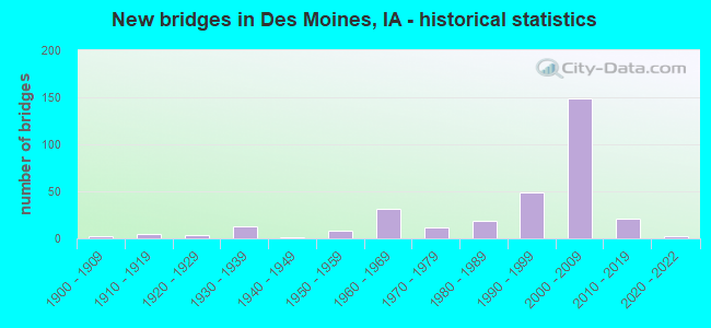
- New bridges - historical statistics
- 21900-1909
- 51910-1919
- 31920-1929
- 131930-1939
- 11940-1949
- 81950-1959
- 311960-1969
- 121970-1979
- 191980-1989
- 491990-1999
- 1492000-2009
- 212010-2019
- 22020-2022
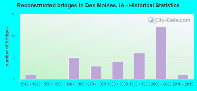
- Reconstructed bridges - Historical Statistics
- 11940-1949
- 01950-1959
- 51960-1969
- 31970-1979
- 41980-1989
- 61990-1999
- 122000-2009
- 12010-2019
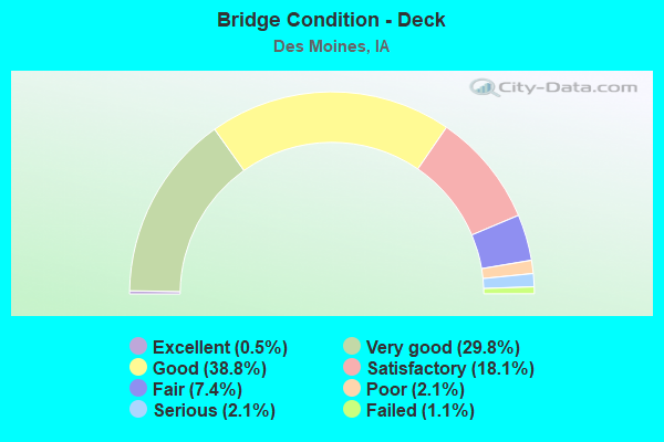
- Bridge Condition - Deck
- 0.5%Excellent
- 29.8%Very good
- 38.8%Good
- 18.1%Satisfactory
- 7.4%Fair
- 2.1%Poor
- 2.1%Serious
- 1.1%Failed
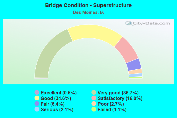
- Bridge Condition - Superstructure
- 0.5%Excellent
- 36.7%Very good
- 34.6%Good
- 16.0%Satisfactory
- 6.4%Fair
- 2.7%Poor
- 2.1%Serious
- 1.1%Failed
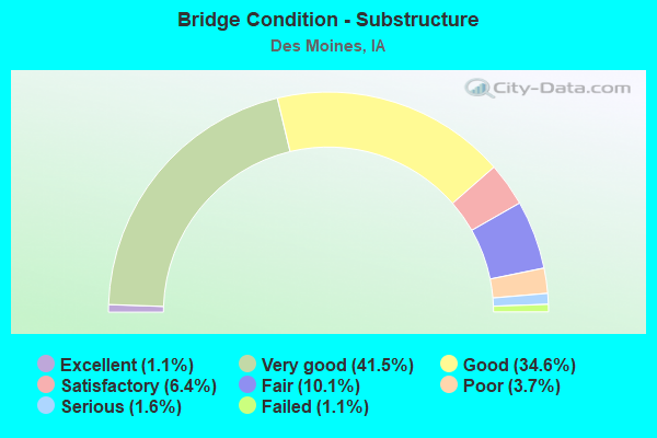
- Bridge Condition - Substructure
- 1.1%Excellent
- 41.5%Very good
- 34.6%Good
- 6.4%Satisfactory
- 10.1%Fair
- 3.7%Poor
- 1.6%Serious
- 1.1%Failed
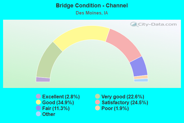
- Bridge Condition - Channel
- 2.8%Excellent
- 22.6%Very good
- 34.9%Good
- 24.5%Satisfactory
- 11.3%Fair
- 1.9%Poor
- 1.9%Serious
- 0.9%Failed
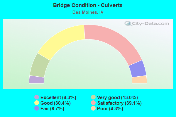
- Bridge Condition - Culverts
- 4.3%Excellent
- 13.0%Very good
- 30.4%Good
- 39.1%Satisfactory
- 8.7%Fair
- 4.3%Poor
Find on map >> Show street view
Structure Number: 60876, Location: 0.9 MI. E OF JCT. US 69 (Lat: 41.603114, Lng: -93.580914), Route carried "on" structure: Interstate 235, Year Built: 2001, Status: Open, Structure Length: 2.83m (9.28ft), Average Daily Traffic: 31,800 (year 2020), Truck Traffic: 8%, Average Future Daily Traffic: 31,800 (year 2040), Design Load: HL 93, Features Intersected: EAST 21ST STREET
Minimum Vertical Clearance: 30+ m (98+ ft), Kilometerpoint: 6.101, Lanes on structure: 4, Lanes under structure: 2, Owner: State Highway Agency, Approaching Roadway Width: 26.3m (86.3ft), Skew: 3 degrees, Material/Design: Prestressed concrete, Design/Construction: Stringer/Multi-beam, Number Of Spans In Main Unit: 1, Length of Maximum Span: 27.4m (89.9ft), Curb-To-Curb Width: 25.3m (83.0ft), Out-to-Out Width: 26.3m (86.3ft)
Condition: Deck: Very good, Superstructure: Very good, Substructure: Very good, Operating Rating: 87.2 metric tons, Method Used To Determine Operating Rating: Load Factor (LF), Inventory Rating: 49.2 metric tons, Method Used To Determine Inventory Rating: Load Factor (LF), Structural Evaluation: Equal to present desirable criteria, Deck Geometry: Superior to present desirable criteria, Underclear: High priority of corrective action, Approach Roadway Alignment: Equal to present desirable criteria, Designated Inspection Frequency: Every 24 months, Inspection Date: June 2020, Deck Structure Type: Concrete Cast-file-Place, Wearing Surface/Protective System: Wearing Surface: Monolithic Concrete, Deck Protection: Epoxy Coated Reinforcing
Find on map >> Show street view
Structure Number: 60895, Location: 4.2 mi. E of Jct. IA #28 (Lat: 41.595364, Lng: -93.624650), Route carried "on" structure: City street , Year Built: 2003, Status: Open, Structure Length: 7.74m (25.39ft), Average Daily Traffic: 3,880 (year 2018), Average Future Daily Traffic: 3,880 (year 2040), Design Load: HS 20, Features Intersected: I-235, Facility Carried by Structure: 5TH AVE
Minimum Vertical Clearance: 30+ m (98+ ft), Kilometerpoint: 1.363, Lanes on structure: 3, Lanes under structure: 8, Owner: State Highway Agency, Approaching Roadway Width: 17.1m (56.1ft), Material/Design: Steel continuous, Design/Construction: Stringer/Multi-beam, Number Of Spans In Main Unit: 2, Length of Maximum Span: 44.8m (147.0ft), Curb-To-Curb Width: 12.6m (41.3ft), Out-to-Out Width: 13.6m (44.6ft)
Condition: Deck: Good, Superstructure: Good, Substructure: Good, Operating Rating: 67.9 metric tons, Method Used To Determine Operating Rating: Load Factor (LF), Inventory Rating: 40.8 metric tons, Method Used To Determine Inventory Rating: Load Factor (LF), Structural Evaluation: Better than present minimum criteria, Deck Geometry: Meets minimum limits, Underclear: Somewhat better than minimum adequacy, Approach Roadway Alignment: Equal to present desirable criteria, Designated Inspection Frequency: Every 24 months, Inspection Date: August 2020, Deck Structure Type: Concrete Cast-file-Place, Wearing Surface/Protective System: Wearing Surface: Monolithic Concrete, Deck Protection: Epoxy Coated Reinforcing
Find on map >> Show street view
Structure Number: 609045, Location: 0.3 mi. E of Jct. IA 163 (Lat: 41.602519, Lng: -93.580831), Route carried "on" structure: Ramp Interstate 235, Year Built: 2006, Status: Open, Structure Length: 2.74m (8.99ft), Average Daily Traffic: 3,060 (year 2020), Truck Traffic: 2%, Average Future Daily Traffic: 3,060 (year 2040), Design Load: HS 20, Features Intersected: EAST 21ST STREET
Minimum Vertical Clearance: 30+ m (98+ ft), Kilometerpoint: 0.201, Lanes on structure: 1, Lanes under structure: 2, Owner: State Highway Agency, Approaching Roadway Width: 10.7m (35.1ft), Skew: 1 degrees, Material/Design: Prestressed concrete, Design/Construction: Stringer/Multi-beam, Number Of Spans In Main Unit: 1, Length of Maximum Span: 9.1m (29.9ft), Curb-To-Curb Width: 7.8m (25.6ft), Out-to-Out Width: 8.7m (28.5ft)
Condition: Deck: Very good, Superstructure: Very good, Substructure: Very good, Operating Rating: 90.5 metric tons, Method Used To Determine Operating Rating: Load Factor (LF), Inventory Rating: 54.1 metric tons, Method Used To Determine Inventory Rating: Load Factor (LF), Structural Evaluation: Equal to present desirable criteria, Deck Geometry: Better than present minimum criteria, Underclear: Better than present minimum criteria, Approach Roadway Alignment: Equal to present desirable criteria, Designated Inspection Frequency: Every 24 months, Inspection Date: October 2020, Deck Structure Type: Concrete Cast-file-Place, Wearing Surface/Protective System: Wearing Surface: Monolithic Concrete, Deck Protection: Epoxy Coated Reinforcing
Find on map >> Show street view
Structure Number: 609255, Location: 0.3 MILE E OF JCT US 69 (Lat: 41.598006, Lng: -93.589775), Route carried "on" structure: Ramp Interstate 235, Year Built: 2004, Status: Open, Structure Length: 15.82m (51.90ft), Average Daily Traffic: 6,400 (year 2020), Truck Traffic: 9%, Average Future Daily Traffic: 6,400 (year 2040), Design Load: HS 20, Features Intersected: E UNIVERSITY RAMP B, Facility Carried by Structure: E 15TH RAMP D
Minimum Vertical Clearance: 30+ m (98+ ft), Kilometerpoint: 0.571, Lanes on structure: 2, Lanes under structure: 2, Owner: State Highway Agency, Approaching Roadway Width: 7.9m (25.9ft), Material/Design: Steel continuous, Design/Construction: Stringer/Multi-beam, Number Of Spans In Main Unit: 3, Length of Maximum Span: 75.3m (247.0ft), Curb-To-Curb Width: 7.8m (25.6ft), Out-to-Out Width: 8.7m (28.5ft)
Condition: Deck: Good, Superstructure: Very good, Substructure: Very good, Operating Rating: 84.3 metric tons, Method Used To Determine Operating Rating: Load Factor (LF), Inventory Rating: 50.6 metric tons, Method Used To Determine Inventory Rating: Load Factor (LF), Structural Evaluation: Equal to present desirable criteria, Deck Geometry: High priority of replacement, Underclear: Superior to present desirable criteria, Approach Roadway Alignment: Equal to present desirable criteria, Designated Inspection Frequency: Every 24 months, Inspection Date: May 2020, Deck Structure Type: Concrete Cast-file-Place, Wearing Surface/Protective System: Wearing Surface: Monolithic Concrete, Deck Protection: Epoxy Coated Reinforcing
Find on map >> Show street view
Structure Number: 60926, Location: 0.6 MI E OF JCT US 69 NB (Lat: 41.601192, Lng: -93.584331), Route carried "on" structure: Interstate 235, Year Built: 2004, Status: Open, Structure Length: 31.88m (104.59ft), Average Daily Traffic: 33,300 (year 2020), Truck Traffic: 8%, Average Future Daily Traffic: 33,300 (year 2040), Design Load: HS 20, Features Intersected: IA 163/UNIV AVE/RAMP
Minimum Vertical Clearance: 30+ m (98+ ft), Kilometerpoint: 6.458, Lanes on structure: 3, Lanes under structure: 5, Owner: State Highway Agency, Approaching Roadway Width: 18.6m (61.0ft), Skew: 5 degrees, Material/Design: Steel continuous, Design/Construction: Stringer/Multi-beam, Number Of Spans In Main Unit: 4, Length of Maximum Span: 72.8m (238.8ft), Curb-To-Curb Width: 18.1m (59.4ft), Out-to-Out Width: 19.1m (62.7ft)
Condition: Deck: Good, Superstructure: Good, Substructure: Very good, Operating Rating: 57.6 metric tons, Method Used To Determine Operating Rating: Load Factor (LF), Inventory Rating: 34.6 metric tons, Method Used To Determine Inventory Rating: Load Factor (LF), Structural Evaluation: Better than present minimum criteria, Deck Geometry: Better than present minimum criteria, Underclear: Equal to present minimum criteria, Approach Roadway Alignment: Equal to present desirable criteria, Designated Inspection Frequency: Every 24 months, Inspection Date: December 2020, Deck Structure Type: Concrete Cast-file-Place, Wearing Surface/Protective System: Wearing Surface: Monolithic Concrete, Deck Protection: Epoxy Coated Reinforcing
Find on map >> Show street view
Structure Number: 609365, Location: 0.5 mi. E of Jct. U.S. 69 (Lat: 41.600864, Lng: -93.586803), Route carried "on" structure: Ramp Interstate 235, Year Built: 2004, Status: Open, Structure Length: 28.59m (93.80ft), Average Daily Traffic: 8,700 (year 2020), Truck Traffic: 9%, Average Future Daily Traffic: 8,700 (year 2041), Design Load: HS 25 or greater, Features Intersected: WB EXIT RAMP, UNIV. AVE., Facility Carried by Structure: UNI AVE WB ENTR
Minimum Vertical Clearance: 30+ m (98+ ft), Kilometerpoint: 0.351, Lanes on structure: 1, Lanes under structure: 5, Owner: State Highway Agency, Approaching Roadway Width: 9.1m (29.9ft), Material/Design: Steel continuous, Design/Construction: Stringer/Multi-beam, Number Of Spans In Main Unit: 5, Length of Maximum Span: 59.4m (194.9ft), Curb-To-Curb Width: 7.8m (25.6ft), Out-to-Out Width: 8.8m (28.9ft)
Condition: Deck: Very good, Superstructure: Very good, Substructure: Very good, Operating Rating: 77.5 metric tons, Method Used To Determine Operating Rating: Load Factor (LF), Inventory Rating: 46.5 metric tons, Method Used To Determine Inventory Rating: Load Factor (LF), Structural Evaluation: Equal to present desirable criteria, Deck Geometry: Better than present minimum criteria, Underclear: Superior to present desirable criteria, Approach Roadway Alignment: Equal to present desirable criteria, Designated Inspection Frequency: Every 24 months, Inspection Date: March 2021, Deck Structure Type: Concrete Cast-file-Place, Wearing Surface/Protective System: Wearing Surface: Monolithic Concrete, Deck Protection: Epoxy Coated Reinforcing
Find on map >> Show street view
Structure Number: 609395, Location: 0.4 mi. E of Jct. IA #163 (Lat: 41.604025, Lng: -93.579792), Route carried "on" structure: Interstate 235, Year Built: 2004, Status: Open, Structure Length: 5.21m (17.09ft), Average Daily Traffic: 32,750 (year 2020), Truck Traffic: 8%, Average Future Daily Traffic: 32,750 (year 2041), Design Load: HS 25 or greater, Features Intersected: EASTON BLVD
Minimum Vertical Clearance: 30+ m (98+ ft), Kilometerpoint: 17.598, Lanes on structure: 3, Lanes under structure: 2, Base Highway Network: Yes, Owner: State Highway Agency, Approaching Roadway Width: 18.3m (60.0ft), Skew: 4 degrees, Material/Design: Steel, Design/Construction: Stringer/Multi-beam, Number Of Spans In Main Unit: 1, Length of Maximum Span: 50.9m (167.0ft), Curb-To-Curb Width: 18.3m (60.0ft), Out-to-Out Width: 19.9m (65.3ft)
Condition: Deck: Very good, Superstructure: Good, Substructure: Very good, Operating Rating: 86.4 metric tons, Method Used To Determine Operating Rating: Load Factor (LF), Inventory Rating: 51.9 metric tons, Method Used To Determine Inventory Rating: Load Factor (LF), Structural Evaluation: Better than present minimum criteria, Deck Geometry: Better than present minimum criteria, Underclear: Equal to present minimum criteria, Approach Roadway Alignment: Equal to present desirable criteria, Designated Inspection Frequency: Every 24 months, Inspection Date: November 2021, Deck Structure Type: Concrete Cast-file-Place, Wearing Surface/Protective System: Wearing Surface: Monolithic Concrete, Deck Protection: Epoxy Coated Reinforcing
Find on map >> Show street view
Structure Number: 60941, Location: 078230600 (Lat: 41.600469, Lng: -93.558775), Route carried "on" structure: State highway 163, Year Built: 2003, Status: Open, Structure Length: 0.64m (2.10ft), Average Daily Traffic: 24,700 (year 2020), Truck Traffic: 5%, Average Future Daily Traffic: 24,700 (year 2041), Design Load: HS 20, Features Intersected: SMALL CREEK, Facility Carried by Structure: E UNIVERSITY
Minimum Vertical Clearance: 30+ m (98+ ft), Kilometerpoint: 3.495, Lanes on structure: 4, Base Highway Network: Yes, Owner: City or Municipal Highway Agency, Approaching Roadway Width: 12.8m (42.0ft), Skew: 2 degrees, Material/Design: Concrete, Design/Construction: Culvert, Number Of Spans In Main Unit: 2, Length of Maximum Span: 3.0m (9.8ft)
Condition: Channel: Very good, Culverts: Very good, Operating Rating: 44.1 metric tons, Method Used To Determine Operating Rating: Assigned rating based on Load Factor Design (LFD) reported in metric tons, Inventory Rating: 32.7 metric tons, Method Used To Determine Inventory Rating: Assigned rating based on Load Factor Design (LFD) reported in metric tons, Structural Evaluation: Equal to present desirable criteria, Waterway Adequacy: Equal to present minimum criteria, Approach Roadway Alignment: Equal to present desirable criteria, Length Of Structure Improvement: 2.10m (6.89ft), Designated Inspection Frequency: Every 24 months, Inspection Date: July 2021, Bridge Improvement Cost: $15,000, Roadway Improvement Cost: $2,000
Find on map >> Show street view
Structure Number: 609695, Location: 3.8 mi. E of Jct. IA 28 (Lat: 41.595628, Lng: -93.632717), Route carried "on" structure: Ramp Interstate 235, Year Built: 2005, Status: Open, Structure Length: 14.14m (46.39ft), Average Daily Traffic: 10,500 (year 2020), Truck Traffic: 3%, Average Future Daily Traffic: 10,500 (year 2041), Design Load: HS 20, Features Intersected: KEO WAY RAMP TO EB I-235
Minimum Vertical Clearance: 30+ m (98+ ft), Kilometerpoint: 0.311, Lanes on structure: 2, Lanes under structure: 1, Owner: State Highway Agency, Approaching Roadway Width: 10.4m (34.1ft), Material/Design: Steel continuous, Design/Construction: Stringer/Multi-beam, Number Of Spans In Main Unit: 3, Length of Maximum Span: 60.4m (198.2ft), Curb-To-Curb Width: 10.2m (33.5ft), Out-to-Out Width: 11.2m (36.7ft)
Condition: Deck: Very good, Superstructure: Good, Substructure: Very good, Operating Rating: 73.0 metric tons, Method Used To Determine Operating Rating: Load Factor (LF), Inventory Rating: 43.7 metric tons, Method Used To Determine Inventory Rating: Load Factor (LF), Structural Evaluation: Better than present minimum criteria, Deck Geometry: Equal to present minimum criteria, Underclear: Somewhat better than minimum adequacy, Approach Roadway Alignment: Equal to present desirable criteria, Designated Inspection Frequency: Every 24 months, Inspection Date: December 2021, Deck Structure Type: Concrete Cast-file-Place, Wearing Surface/Protective System: Wearing Surface: Monolithic Concrete, Deck Protection: Epoxy Coated Reinforcing
Find on map >> Show street view
Structure Number: 609985, Location: 000000000 (Lat: 41.539003, Lng: -93.562542), Route carried "on" structure: State lands road , Year Built: 1968, Year Reconstructed: 1999, Status: Open, Structure Length: 0.70m (2.30ft), Design Load: HS 20, Features Intersected: STREAM, Facility Carried by Structure: EASTER LK PK
Minimum Vertical Clearance: 30+ m (98+ ft), Kilometerpoint: 0.240, Lanes on structure: 2, Owner: County Highway Agency, Approaching Roadway Width: 7.2m (23.6ft), Material/Design: Wood or Timber, Design/Construction: Stringer/Multi-beam, Number Of Spans In Main Unit: 1, Length of Maximum Span: 6.4m (21.0ft), Curb-To-Curb Width: 7.2m (23.6ft), Out-to-Out Width: 7.8m (25.6ft)
Condition: Deck: Good, Superstructure: Satisfactory, Substructure: Fair, Channel: Satisfactory, Operating Rating: 47.2 metric tons, Method Used To Determine Operating Rating: Allowable Stress (AS), Inventory Rating: 33.5 metric tons, Method Used To Determine Inventory Rating: Allowable Stress (AS), Structural Evaluation: Somewhat better than minimum adequacy, Deck Geometry: Somewhat better than minimum adequacy, Waterway Adequacy: Somewhat better than minimum adequacy, Approach Roadway Alignment: Equal to present minimum criteria, Designated Inspection Frequency: Every 24 months, Inspection Date: April 2020, Deck Structure Type: Wood or Timber, Wearing Surface/Protective System: Wearing Surface: Bituminous
Find on map >> Show street view
Structure Number: 700175, Location: 1.0 MI N OF SE 64TH AVE (Lat: 41.539442, Lng: -93.516928), Route carried "on" structure: US 65, Year Built: 2013, Status: Open, Structure Length: 14.30m (46.92ft), Average Daily Traffic: 11,200 (year 2020), Truck Traffic: 12%, Average Future Daily Traffic: 11,200 (year 2042), Design Load: HL 93, Features Intersected: DES MONIES RVR S OVERFLO
Minimum Vertical Clearance: 30+ m (98+ ft), Kilometerpoint: 118.681, Lanes on structure: 2, Base Highway Network: Yes, Owner: State Highway Agency, Approaching Roadway Width: 13.4m (44.0ft), Material/Design: Prestressed concrete, Design/Construction: Stringer/Multi-beam, Number Of Spans In Main Unit: 4, Length of Maximum Span: 34.4m (112.9ft), Curb-To-Curb Width: 12.2m (40.0ft), Out-to-Out Width: 13.2m (43.3ft)
Condition: Deck: Good, Superstructure: Good, Substructure: Good, Channel: Excellent, Operating Rating: 42.1 metric tons, Method Used To Determine Operating Rating: Assigned ratings based on Load and Resistance Factor Design (LRFD) reported by rating factor (RF) using HL93 loadings, Inventory Rating: 32.4 metric tons, Method Used To Determine Inventory Rating: Assigned ratings based on Load and Resistance Factor Design (LRFD) reported by rating factor (RF) using HL93 loadings, Structural Evaluation: Better than present minimum criteria, Deck Geometry: Better than present minimum criteria, Waterway Adequacy: Superior to present desirable criteria, Approach Roadway Alignment: Equal to present desirable criteria, Designated Inspection Frequency: Every 24 months, Inspection Date: Febuary 2022, Deck Structure Type: Concrete Cast-file-Place, Wearing Surface/Protective System: Wearing Surface: Monolithic Concrete, Deck Protection: Epoxy Coated Reinforcing
Find on map >> Show street view
Structure Number: 70018, Location: 1.1 MI. N OF SE 64th Ave. (Lat: 41.540667, Lng: -93.516725), Route carried "on" structure: US 65, Year Built: 2014, Status: Open, Structure Length: 14.30m (46.92ft), Average Daily Traffic: 11,200 (year 2020), Truck Traffic: 12%, Average Future Daily Traffic: 11,200 (year 2040), Design Load: HL 93, Features Intersected: DES MOINES RVR S OVERFLO
Minimum Vertical Clearance: 30+ m (98+ ft), Kilometerpoint: 238.675, Lanes on structure: 2, Owner: State Highway Agency, Approaching Roadway Width: 14.6m (47.9ft), Material/Design: Prestressed concrete, Design/Construction: Stringer/Multi-beam, Number Of Spans In Main Unit: 4, Length of Maximum Span: 35.7m (117.1ft), Curb-To-Curb Width: 12.2m (40.0ft), Out-to-Out Width: 13.2m (43.3ft)
Condition: Deck: Good, Superstructure: Very good, Substructure: Very good, Channel: Very good, Operating Rating: 42.1 metric tons, Method Used To Determine Operating Rating: Assigned ratings based on Load and Resistance Factor Design (LRFD) reported by rating factor (RF) using HL93 loadings, Inventory Rating: 32.4 metric tons, Method Used To Determine Inventory Rating: Assigned ratings based on Load and Resistance Factor Design (LRFD) reported by rating factor (RF) using HL93 loadings, Structural Evaluation: Equal to present desirable criteria, Deck Geometry: Better than present minimum criteria, Waterway Adequacy: Superior to present desirable criteria, Approach Roadway Alignment: Equal to present desirable criteria, Designated Inspection Frequency: Every 24 months, Inspection Date: October 2020, Deck Structure Type: Concrete Cast-file-Place, Wearing Surface/Protective System: Wearing Surface: Monolithic Concrete, Deck Protection: Epoxy Coated Reinforcing
Find on map >> Show street view
Structure Number: 70022, Location: 1.4 MI N OF SE 64TH AVE (Lat: 41.544750, Lng: -93.514578), Route carried "on" structure: US 65, Year Built: 2013, Status: Open, Structure Length: 21.45m (70.37ft), Average Daily Traffic: 11,200 (year 2020), Truck Traffic: 12%, Average Future Daily Traffic: 11,200 (year 2042), Design Load: HL 93, Features Intersected: DES MOINES RIVER OVERFLO
Minimum Vertical Clearance: 30+ m (98+ ft), Kilometerpoint: 119.302, Lanes on structure: 2, Base Highway Network: Yes, Owner: State Highway Agency, Approaching Roadway Width: 13.4m (44.0ft), Material/Design: Prestressed concrete, Design/Construction: Stringer/Multi-beam, Number Of Spans In Main Unit: 6, Length of Maximum Span: 34.7m (113.8ft), Curb-To-Curb Width: 12.2m (40.0ft), Out-to-Out Width: 13.2m (43.3ft)
Condition: Deck: Good, Superstructure: Very good, Substructure: Good, Channel: Very good, Operating Rating: 42.1 metric tons, Method Used To Determine Operating Rating: Assigned ratings based on Load and Resistance Factor Design (LRFD) reported by rating factor (RF) using HL93 loadings, Inventory Rating: 32.4 metric tons, Method Used To Determine Inventory Rating: Assigned ratings based on Load and Resistance Factor Design (LRFD) reported by rating factor (RF) using HL93 loadings, Structural Evaluation: Better than present minimum criteria, Deck Geometry: Better than present minimum criteria, Waterway Adequacy: Superior to present desirable criteria, Approach Roadway Alignment: Equal to present desirable criteria, Designated Inspection Frequency: Every 24 months, Inspection Date: Febuary 2022, Deck Structure Type: Concrete Cast-file-Place, Wearing Surface/Protective System: Wearing Surface: Monolithic Concrete, Deck Protection: Epoxy Coated Reinforcing
Find on map >> Show street view
Structure Number: 700225, Location: 1.1 MI. N of SE 64th AVE. (Lat: 41.546872, Lng: -93.513983), Route carried "on" structure: US 65, Year Built: 2014, Status: Open, Structure Length: 21.52m (70.60ft), Average Daily Traffic: 11,200 (year 2020), Truck Traffic: 12%, Average Future Daily Traffic: 11,200 (year 2040), Design Load: HL 93, Features Intersected: DES MOINES RVR MID OVFLO
Minimum Vertical Clearance: 30+ m (98+ ft), Kilometerpoint: 237.950, Lanes on structure: 2, Owner: State Highway Agency, Approaching Roadway Width: 14.6m (47.9ft), Material/Design: Prestressed concrete, Design/Construction: Stringer/Multi-beam, Number Of Spans In Main Unit: 6, Length of Maximum Span: 35.7m (117.1ft), Curb-To-Curb Width: 12.2m (40.0ft), Out-to-Out Width: 13.2m (43.3ft)
Condition: Deck: Very good, Superstructure: Very good, Substructure: Very good, Channel: Excellent, Operating Rating: 42.1 metric tons, Method Used To Determine Operating Rating: Assigned ratings based on Load and Resistance Factor Design (LRFD) reported by rating factor (RF) using HL93 loadings, Inventory Rating: 32.4 metric tons, Method Used To Determine Inventory Rating: Assigned ratings based on Load and Resistance Factor Design (LRFD) reported by rating factor (RF) using HL93 loadings, Structural Evaluation: Equal to present desirable criteria, Deck Geometry: Better than present minimum criteria, Waterway Adequacy: Superior to present desirable criteria, Approach Roadway Alignment: Equal to present desirable criteria, Designated Inspection Frequency: Every 24 months, Inspection Date: October 2020, Deck Structure Type: Concrete Cast-file-Place, Wearing Surface/Protective System: Wearing Surface: Monolithic Concrete, Deck Protection: Epoxy Coated Reinforcing
Find on map >> Show street view
Structure Number: 3773, Location: 078240500 (Lat: 41.600425, Lng: -93.638717), Route carried "under" structure: City street , Year Built: 1987, Structure Length: 0. m, Average Daily Traffic: 11,700 (year 1984), Features Intersected: KEOSAUQUA, Facility Carried by Structure: UNIV AVE
Minimum Vertical Clearance: 30+ m (98+ ft), Kilometerpoint: 1.394, Lanes on structure: 4, Lanes under structure: 4, Material/Design: Prestressed concrete, Design/Construction: Stringer/Multi-beam, Length of Maximum Span: 31.1m (102.0ft)
Find on map >> Show street view
Structure Number: 39, Location: 078241700 (Lat: 41.565753, Lng: -93.644914), Route carried "under" structure: City street , Year Built: 1936, Structure Length: 0. m, Average Daily Traffic: 2,275 (year 1998), Features Intersected: OLD UP RR & SW 22ND, Facility Carried by Structure: FLEUR DR
Minimum Vertical Clearance: 30+ m (98+ ft), Kilometerpoint: 1.595, Lanes on structure: 4, Lanes under structure: 2, Material/Design: Steel continuous, Design/Construction: Stringer/Multi-beam, Length of Maximum Span: 23.5m (77.1ft)
Find on map >> Show street view
Structure Number: 396, Location: 078240900 (Lat: 41.571367, Lng: -93.623178), Route carried "under" structure: City street , Year Built: 1967, Structure Length: 0. m, Average Daily Traffic: 8,100 (year 2012), Features Intersected: RACCOON RIVER & TRAIL, Facility Carried by Structure: SW 9TH ST
Minimum Vertical Clearance: 30+ m (98+ ft), Kilometerpoint: 0.008, Lanes on structure: 4, Lanes under structure: 4, Material/Design: Prestressed concrete, Design/Construction: Stringer/Multi-beam, Length of Maximum Span: 25.0m (82.0ft)
Find on map >> Show street view
Structure Number: 3961, Location: 078240900 (Lat: 41.583994, Lng: -93.627947), Route carried "under" structure: City street , Year Built: 1967, Structure Length: 0. m, Average Daily Traffic: 1,970 (year 2016), Features Intersected: CHERRY, RR, MLK PKWY, Facility Carried by Structure: SW 9TH ST
Minimum Vertical Clearance: 30+ m (98+ ft), Kilometerpoint: 0.311, Lanes on structure: 2, Lanes under structure: 6, Material/Design: Steel continuous, Design/Construction: Girder and Floorbeam System, Length of Maximum Span: 39.6m (129.9ft)
Find on map >> Show street view
Structure Number: 3974, Location: 078240900 (Lat: 41.579881, Lng: -93.625050), Route carried "under" structure: City street , Year Built: 1967, Structure Length: 0. m, Average Daily Traffic: 7,800 (year 2016), Features Intersected: RR, CHERRY, MLK JR PKWY, Facility Carried by Structure: SW 8TH ST
Minimum Vertical Clearance: 30+ m (98+ ft), Kilometerpoint: 1.009, Lanes on structure: 2, Lanes under structure: 6, Material/Design: Steel continuous, Design/Construction: Girder and Floorbeam System, Length of Maximum Span: 47.9m (157.2ft)
Find on map >> Show street view
Structure Number: 401, Location: 079243400 (Lat: 41.613258, Lng: -93.625461), Route carried "under" structure: State lands road , Year Built: 1966, Structure Length: 0. m, Average Daily Traffic: 351 (year 2015), Features Intersected: DES MOINES RVR & BIRDLAN, Facility Carried by Structure: 6TH AVE
Minimum Vertical Clearance: 30+ m (98+ ft), Kilometerpoint: 0.167, Lanes on structure: 4, Lanes under structure: 2, Material/Design: Steel continuous, Design/Construction: Stringer/Multi-beam, Length of Maximum Span: 36.3m (119.1ft)
Find on map >> Show street view
Structure Number: 4111, Location: 5.1 mi. E of Jct. IA #28 (Lat: 41.594361, Lng: -93.606442), Route carried "under" structure: Interstate 235, Year Built: 2001, Structure Length: 0. m, Average Daily Traffic: 70,900 (year 2020), Truck Traffic: 8%, Features Intersected: I-235, Facility Carried by Structure: E 9TH STREET
Minimum Vertical Clearance: 30+ m (98+ ft), Kilometerpoint: 15.086, Lanes on structure: 2, Lanes under structure: 10, Material/Design: Steel continuous, Design/Construction: Stringer/Multi-beam, Length of Maximum Span: 38.7m (127.0ft)
Find on map >> Show street view
Structure Number: 4051, Location: 0.7 MILE S OF JCT I-235 (Lat: 41.583419, Lng: -93.596808), Route carried "under" structure: City street , Year Built: 1937, Structure Length: 0. m, Average Daily Traffic: 2,250 (year 2012), Features Intersected: RR SCOTT AVE & MLK PKWY, Facility Carried by Structure: US 69
Minimum Vertical Clearance: 30+ m (98+ ft), Kilometerpoint: 1.193, Lanes on structure: 4, Lanes under structure: 6, Material/Design: Steel continuous, Design/Construction: Stringer/Multi-beam, Length of Maximum Span: 32.9m (107.9ft)
Find on map >> Show street view
Structure Number: 40521, Location: At the Jct. I-235 (Lat: 41.596317, Lng: -93.599006), Route carried "under" structure: Interstate 235, Year Built: 2003, Structure Length: 0. m, Average Daily Traffic: 63,900 (year 2020), Truck Traffic: 8%, Features Intersected: I-235, Facility Carried by Structure: E 14TH ST-US 69 SB
Minimum Vertical Clearance: 30+ m (98+ ft), Kilometerpoint: 15.728, Lanes on structure: 3, Lanes under structure: 8, Material/Design: Steel continuous, Design/Construction: Stringer/Multi-beam, Length of Maximum Span: 41.1m (134.8ft)
Find on map >> Show street view
Structure Number: 41521, Location: 1.7 MI. WEST OF IA 415 (Lat: 41.649806, Lng: -93.652536), Route carried "under" structure: Interstate 80, Year Built: 2017, Structure Length: 0. m, Average Daily Traffic: 85,600 (year 2020), Truck Traffic: 19%, Features Intersected: I 35 & I 80, Facility Carried by Structure: NW 26TH ST
Minimum Vertical Clearance: 30+ m (98+ ft), Kilometerpoint: 214.838, Lanes on structure: 2, Lanes under structure: 6, Material/Design: Prestressed concrete, Design/Construction: Stringer/Multi-beam, Length of Maximum Span: 46.1m (151.2ft)
Find on map >> Show street view
Structure Number: 41591, Location: At Jct. of IA #415 (Lat: 41.649394, Lng: -93.620433), Route carried "under" structure: State highway 415, Year Built: 1999, Structure Length: 0. m, Average Daily Traffic: 14,700 (year 2020), Truck Traffic: 5%, Features Intersected: IA 415, Facility Carried by Structure: NB I 35 EB I 80
Minimum Vertical Clearance: 30+ m (98+ ft), Kilometerpoint: 2.404, Lanes on structure: 3, Lanes under structure: 4, Material/Design: Steel continuous, Design/Construction: Stringer/Multi-beam, Length of Maximum Span: 39.9m (130.9ft)
Find on map >> Show street view
Structure Number: 41601, Location: At Jct. of IA 415 (Lat: 41.649575, Lng: -93.619472), Route carried "under" structure: State highway 415, Year Built: 1999, Structure Length: 0. m, Average Daily Traffic: 14,700 (year 2020), Truck Traffic: 5%, Features Intersected: IA 415, Facility Carried by Structure: I 80 WB I 35 SB
Minimum Vertical Clearance: 30+ m (98+ ft), Kilometerpoint: 2.424, Lanes on structure: 3, Lanes under structure: 4, Material/Design: Steel continuous, Design/Construction: Stringer/Multi-beam, Length of Maximum Span: 39.9m (130.9ft)
Find on map >> Show street view
Structure Number: 41611, Location: 0.3 mi. E of Jct. IA 415 (Lat: 41.649403, Lng: -93.615344), Route carried "under" structure: County highway , Year Built: 2000, Structure Length: 0. m, Average Daily Traffic: 1,270 (year 2016), Features Intersected: NE 3RD ST, Facility Carried by Structure: NB I-35,EB I-80
Minimum Vertical Clearance: 30+ m (98+ ft), Kilometerpoint: 1.395, Lanes on structure: 3, Lanes under structure: 2, Material/Design: Prestressed concrete, Design/Construction: Stringer/Multi-beam, Length of Maximum Span: 36.6m (120.1ft)
Find on map >> Show street view
Structure Number: 41621, Location: 0.3 mi. E of Jct. 415 (Lat: 41.649581, Lng: -93.614900), Route carried "under" structure: County highway , Year Built: 2000, Structure Length: 0. m, Average Daily Traffic: 1,270 (year 2016), Features Intersected: NE 3RD ST, Facility Carried by Structure: SB I-35,WB I-80
Minimum Vertical Clearance: 30+ m (98+ ft), Kilometerpoint: 1.415, Lanes on structure: 3, Lanes under structure: 2, Material/Design: Prestressed concrete, Design/Construction: Stringer/Multi-beam, Length of Maximum Span: 36.6m (120.1ft)
Find on map >> Show street view
Structure Number: 41631, Location: AT JUNCTION WITH US 69 (Lat: 41.649761, Lng: -93.600894), Route carried "under" structure: US 69, Year Built: 2000, Structure Length: 0. m, Average Daily Traffic: 8,550 (year 2020), Truck Traffic: 14%, Features Intersected: US 69, Facility Carried by Structure: NB I-35,EB I-80
Minimum Vertical Clearance: 30+ m (98+ ft), Kilometerpoint: 145.485, Lanes on structure: 4, Lanes under structure: 4, Material/Design: Steel continuous, Design/Construction: Stringer/Multi-beam, Length of Maximum Span: 39.0m (128.0ft)
Find on map >> Show street view
Structure Number: 41641, Location: AT JUNCTION WITH US 69 (Lat: 41.649992, Lng: -93.599964), Route carried "under" structure: US 69, Year Built: 2000, Structure Length: 0. m, Average Daily Traffic: 8,550 (year 2020), Truck Traffic: 14%, Features Intersected: US 69, Facility Carried by Structure: SB I-35,WB I-80
Minimum Vertical Clearance: 30+ m (98+ ft), Kilometerpoint: 145.509, Lanes on structure: 4, Lanes under structure: 5, Material/Design: Steel continuous, Design/Construction: Stringer/Multi-beam, Length of Maximum Span: 38.7m (127.0ft)
Find on map >> Show street view
Structure Number: 4199, Location: 1.6 MILES E OF E JCT I-35 (Lat: 41.656467, Lng: -93.542967), Route carried "under" structure: Interstate 80, Year Built: 1959, Structure Length: 0. m, Average Daily Traffic: 74,000 (year 2020), Truck Traffic: 18%, Features Intersected: I 80, Facility Carried by Structure: NE 38TH ST
Minimum Vertical Clearance: 30+ m (98+ ft), Kilometerpoint: 224.074, Lanes on structure: 2, Lanes under structure: 6, Material/Design: Prestressed concrete, Design/Construction: Stringer/Multi-beam, Length of Maximum Span: 21.0m (68.9ft)
Find on map >> Show street view
Structure Number: 42291, Location: At Jct. I-235 (Lat: 41.592822, Lng: -93.703456), Route carried "under" structure: Interstate 235, Year Built: 2004, Structure Length: 0. m, Average Daily Traffic: 92,200 (year 2020), Truck Traffic: 6%, Features Intersected: I-235, Facility Carried by Structure: IA 28
Minimum Vertical Clearance: 30+ m (98+ ft), Kilometerpoint: 6.862, Lanes on structure: 4, Lanes under structure: 6, Material/Design: Prestressed concrete, Design/Construction: Stringer/Multi-beam, Length of Maximum Span: 36.9m (121.1ft)
Find on map >> Show street view
Structure Number: 423, Location: 0.2 MILE E OF JCT IA 28 (Lat: 41.592844, Lng: -93.700169), Route carried "under" structure: City street , Year Built: 1967, Structure Length: 0. m, Average Daily Traffic: 280 (year 2012), Features Intersected: CUMMINS PARKWAY, Facility Carried by Structure: EB I-235
Minimum Vertical Clearance: 30+ m (98+ ft), Kilometerpoint: 0.146, Lanes on structure: 4, Lanes under structure: 2, Material/Design: Concrete continuous, Design/Construction: Slab, Length of Maximum Span: 16.5m (54.1ft)
Find on map >> Show street view
Structure Number: 4231, Location: 0.2 MILE E OF JCT IA 28 (Lat: 41.592947, Lng: -93.699014), Route carried "under" structure: City street , Year Built: 1967, Structure Length: 0. m, Average Daily Traffic: 280 (year 2012), Features Intersected: CUMMINS PARKWAY, Facility Carried by Structure: WB I-235
Minimum Vertical Clearance: 30+ m (98+ ft), Kilometerpoint: 0.172, Lanes on structure: 5, Lanes under structure: 2, Material/Design: Concrete continuous, Design/Construction: Slab, Length of Maximum Span: 16.5m (54.1ft)
Find on map >> Show street view
Structure Number: 42321, Location: 0.5 mi. E of Jct. IA #28 (Lat: 41.592192, Lng: -93.693725), Route carried "under" structure: Interstate 235, Year Built: 2005, Structure Length: 0. m, Average Daily Traffic: 103,800 (year 2020), Truck Traffic: 6%, Features Intersected: I-235, Facility Carried by Structure: 56TH ST
Minimum Vertical Clearance: 30+ m (98+ ft), Kilometerpoint: 7.686, Lanes on structure: 2, Lanes under structure: 8, Material/Design: Steel continuous, Design/Construction: Stringer/Multi-beam, Length of Maximum Span: 43.3m (142.1ft)
Find on map >> Show street view
Structure Number: 42331, Location: 1.1 MILES E OF JCT IA 28 (Lat: 41.592003, Lng: -93.681706), Route carried "under" structure: Interstate 235, Year Built: 2003, Structure Length: 0. m, Average Daily Traffic: 55,750 (year 2020), Truck Traffic: 6%, Features Intersected: I-235, Facility Carried by Structure: SB(EB) POLK BLV
Minimum Vertical Clearance: 30+ m (98+ ft), Kilometerpoint: 8.700, Lanes on structure: 2, Lanes under structure: 6, Material/Design: Prestressed concrete, Design/Construction: Stringer/Multi-beam, Length of Maximum Span: 30.8m (101.0ft)
Find on map >> Show street view
Structure Number: 42341, Location: 1.2 mi. E of Jct. IA #28 (Lat: 41.591447, Lng: -93.681556), Route carried "under" structure: Interstate 235, Year Built: 2003, Structure Length: 0. m, Average Daily Traffic: 55,750 (year 2020), Truck Traffic: 6%, Features Intersected: I-235, Facility Carried by Structure: NB(WB) POLK BLV
Minimum Vertical Clearance: 30+ m (98+ ft), Kilometerpoint: 8.716, Lanes on structure: 2, Lanes under structure: 6, Material/Design: Prestressed concrete, Design/Construction: Stringer/Multi-beam, Length of Maximum Span: 30.8m (101.0ft)
Find on map >> Show street view
Structure Number: 42361, Location: 1.5 MI EAST OF JCT IA 28 (Lat: 41.590961, Lng: -93.674383), Route carried "under" structure: Interstate 235, Year Built: 2003, Structure Length: 0. m, Average Daily Traffic: 100,700 (year 2020), Truck Traffic: 6%, Features Intersected: I-235, Facility Carried by Structure: 42ND ST SW
Minimum Vertical Clearance: 30+ m (98+ ft), Kilometerpoint: 9.312, Lanes on structure: 3, Lanes under structure: 9, Material/Design: Prestressed concrete, Design/Construction: Stringer/Multi-beam, Length of Maximum Span: 35.1m (115.2ft)
Find on map >> Show street view
Structure Number: 42381, Location: 2.0 MILES E OF JCT IA 28 (Lat: 41.593058, Lng: -93.664506), Route carried "under" structure: City street , Year Built: 2004, Structure Length: 0. m, Average Daily Traffic: 2,190 (year 2016), Features Intersected: 35TH STREET, Facility Carried by Structure: EB I-235
Minimum Vertical Clearance: 30+ m (98+ ft), Kilometerpoint: 1.228, Lanes on structure: 5, Lanes under structure: 2, Material/Design: Prestressed concrete, Design/Construction: Stringer/Multi-beam, Length of Maximum Span: 21.6m (70.9ft)
Find on map >> Show street view
Structure Number: 42391, Location: 2.1 mi. E of Jct. IA #28 (Lat: 41.593261, Lng: -93.663906), Route carried "under" structure: City street , Year Built: 2005, Structure Length: 0. m, Average Daily Traffic: 2,190 (year 2016), Features Intersected: 35TH STREET, Facility Carried by Structure: WB I-235
Minimum Vertical Clearance: 30+ m (98+ ft), Kilometerpoint: 1.255, Lanes on structure: 5, Lanes under structure: 2, Material/Design: Prestressed concrete, Design/Construction: Stringer/Multi-beam, Length of Maximum Span: 23.5m (77.1ft)
Find on map >> Show street view
Structure Number: 42401, Location: 2.3 mi. E of Jct. IA #28 (Lat: 41.592825, Lng: -93.659367), Route carried "under" structure: Interstate 235, Year Built: 2005, Structure Length: 0. m, Average Daily Traffic: 100,000 (year 2020), Truck Traffic: 6%, Features Intersected: I-235, Facility Carried by Structure: 31ST STREET
Minimum Vertical Clearance: 30+ m (98+ ft), Kilometerpoint: 10.607, Lanes on structure: 4, Lanes under structure: 8, Material/Design: Prestressed concrete, Design/Construction: Stringer/Multi-beam, Length of Maximum Span: 30.5m (100.1ft)
Find on map >> Show street view
Structure Number: 42411, Location: 2.6 MILES E OF JCT. IA 28 (Lat: 41.593106, Lng: -93.654722), Route carried "under" structure: City street , Year Built: 2004, Structure Length: 0. m, Average Daily Traffic: 1,980 (year 2000), Features Intersected: 28TH STREET, Facility Carried by Structure: EB I-235
Minimum Vertical Clearance: 30+ m (98+ ft), Kilometerpoint: 1.526, Lanes on structure: 5, Lanes under structure: 2, Material/Design: Prestressed concrete, Design/Construction: Stringer/Multi-beam, Length of Maximum Span: 23.5m (77.1ft)
Find on map >> Show street view
Structure Number: 42421, Location: 2.6 mi. E of Jct. IA #28 (Lat: 41.593411, Lng: -93.654217), Route carried "under" structure: City street , Year Built: 2005, Structure Length: 0. m, Average Daily Traffic: 895 (year 2012), Features Intersected: 28TH STREET, Facility Carried by Structure: WB I-235
Minimum Vertical Clearance: 30+ m (98+ ft), Kilometerpoint: 1.556, Lanes on structure: 5, Lanes under structure: 2, Material/Design: Prestressed concrete, Design/Construction: Stringer/Multi-beam, Length of Maximum Span: 23.2m (76.1ft)
Find on map >> Show street view
Structure Number: 42431, Location: 3.0 mi. E of Jct. IA #28 (Lat: 41.595656, Lng: -93.648506), Route carried "under" structure: Interstate 235, Year Built: 2003, Structure Length: 0. m, Average Daily Traffic: 95,800 (year 2020), Truck Traffic: 7%, Features Intersected: COTTAGE GROVE, Facility Carried by Structure: COTTAGE GROVE
Minimum Vertical Clearance: 30+ m (98+ ft), Kilometerpoint: 11.629, Lanes on structure: 2, Lanes under structure: 10, Material/Design: Steel continuous, Design/Construction: Stringer/Multi-beam, Length of Maximum Span: 61.9m (203.1ft)
Find on map >> Show street view
Structure Number: 42491, Location: 3.3 MILES E OF JCT IA 28 (Lat: 41.595483, Lng: -93.642550), Route carried "under" structure: Interstate 235, Year Built: 2003, Structure Length: 0. m, Average Daily Traffic: 80,500 (year 2020), Truck Traffic: 8%, Features Intersected: I-235, Facility Carried by Structure: W 19TH ST
Minimum Vertical Clearance: 30+ m (98+ ft), Kilometerpoint: 12.070, Lanes on structure: 4, Lanes under structure: 9, Material/Design: Steel continuous, Design/Construction: Stringer/Multi-beam, Length of Maximum Span: 38.1m (125.0ft)
Find on map >> Show street view
Structure Number: 42511, Location: 3.6 mi. E of Jct. IA #28 (Lat: 41.595883, Lng: -93.636947), Route carried "under" structure: City street , Year Built: 2006, Structure Length: 0. m, Average Daily Traffic: 4,900 (year 2018), Features Intersected: KEO WAY, Facility Carried by Structure: EB I-235
Minimum Vertical Clearance: 30+ m (98+ ft), Kilometerpoint: 0.830, Lanes on structure: 3, Lanes under structure: 8, Material/Design: Steel continuous, Design/Construction: Stringer/Multi-beam, Length of Maximum Span: 47.5m (155.8ft)
Find on map >> Show street view
Structure Number: 42521, Location: 3.6 MILES E OF JCT IA 28 (Lat: 41.596119, Lng: -93.635014), Route carried "under" structure: City street , Year Built: 2005, Structure Length: 0. m, Average Daily Traffic: 4,900 (year 2018), Features Intersected: KEO WAY, Facility Carried by Structure: WB I-235
Minimum Vertical Clearance: 30+ m (98+ ft), Kilometerpoint: 0.863, Lanes on structure: 3, Lanes under structure: 8, Material/Design: Steel continuous, Design/Construction: Stringer/Multi-beam, Length of Maximum Span: 47.5m (155.8ft)
Find on map >> Show street view
Structure Number: 42571, Location: 3.9 mi. E of Jct. IA #28 (Lat: 41.595378, Lng: -93.629250), Route carried "under" structure: Interstate 235, Year Built: 2007, Structure Length: 0. m, Average Daily Traffic: 69,400 (year 2020), Truck Traffic: 8%, Features Intersected: I-235, Facility Carried by Structure: 9TH STREET
Minimum Vertical Clearance: 30+ m (98+ ft), Kilometerpoint: 13.176, Lanes on structure: 4, Lanes under structure: 10, Material/Design: Steel continuous, Design/Construction: Stringer/Multi-beam, Length of Maximum Span: 36.9m (121.1ft)
Find on map >> Show street view
Structure Number: 42611, Location: 1.5 mi. W of US 69 (Lat: 41.596008, Lng: -93.626878), Route carried "under" structure: Interstate 235, Year Built: 2003, Structure Length: 0. m, Average Daily Traffic: 79,400 (year 2020), Truck Traffic: 7%, Features Intersected: I-235/3RD ST. RAMP B, Facility Carried by Structure: 7TH ST
Minimum Vertical Clearance: 30+ m (98+ ft), Kilometerpoint: 13.380, Lanes on structure: 3, Lanes under structure: 7, Material/Design: Steel continuous, Design/Construction: Stringer/Multi-beam, Length of Maximum Span: 44.5m (146.0ft)
Find on map >> Show street view
Structure Number: 42621, Location: 1.4 miles west of US 69 (Lat: 41.595350, Lng: -93.625669), Route carried "under" structure: Interstate 235, Year Built: 2004, Structure Length: 0. m, Average Daily Traffic: 79,400 (year 2020), Truck Traffic: 7%, Features Intersected: I-235, Facility Carried by Structure: 6TH AVE
Minimum Vertical Clearance: 30+ m (98+ ft), Kilometerpoint: 13.477, Lanes on structure: 4, Lanes under structure: 8, Material/Design: Steel continuous, Design/Construction: Stringer/Multi-beam, Length of Maximum Span: 44.2m (145.0ft)
Find on map >> Show street view
Structure Number: 42641, Location: 4.2 mi. E of Jct. IA 28 (Lat: 41.595306, Lng: -93.624311), Route carried "under" structure: Ramp Interstate 235, Year Built: 2005, Structure Length: 0. m, Average Daily Traffic: 4,270 (year 2020), Truck Traffic: 4%, Features Intersected: I-235 EB RAMP, Facility Carried by Structure: S-E CONN TO 3RD
Minimum Vertical Clearance: 30+ m (98+ ft), Kilometerpoint: 1.046, Lanes on structure: 1, Lanes under structure: 1, Material/Design: Steel, Design/Construction: Stringer/Multi-beam, Length of Maximum Span: 45.8m (150.3ft)
Find on map >> Show street view
Structure Number: 42711, Location: 4.3 mi. E of Jct. IA #28 (Lat: 41.596236, Lng: -93.621522), Route carried "under" structure: Interstate 235, Year Built: 2003, Structure Length: 0. m, Average Daily Traffic: 73,400 (year 2020), Truck Traffic: 8%, Features Intersected: I-235, Facility Carried by Structure: 3RD ST
Minimum Vertical Clearance: 30+ m (98+ ft), Kilometerpoint: 13.824, Lanes on structure: 4, Lanes under structure: 10, Material/Design: Steel continuous, Design/Construction: Stringer/Multi-beam, Length of Maximum Span: 35.1m (115.2ft)
Find on map >> Show street view
Structure Number: 42721, Location: 4.4 mi. E of Jct. IA #28 (Lat: 41.595397, Lng: -93.619833), Route carried "under" structure: Interstate 235, Year Built: 2002, Structure Length: 0. m, Average Daily Traffic: 78,300 (year 2020), Truck Traffic: 7%, Features Intersected: S-W CONN OVER WB I-235, Facility Carried by Structure: 2ND AVE ON RAMP
Minimum Vertical Clearance: 30+ m (98+ ft), Kilometerpoint: 13.967, Lanes on structure: 1, Lanes under structure: 3, Material/Design: Steel continuous, Design/Construction: Stringer/Multi-beam, Length of Maximum Span: 25.9m (85.0ft)
Find on map >> Show street view
Structure Number: 42731, Location: 4.4 mi. E of Jct. IA #28 (Lat: 41.595403, Lng: -93.619783), Route carried "under" structure: Interstate 235, Year Built: 2003, Structure Length: 0. m, Average Daily Traffic: 78,300 (year 2020), Truck Traffic: 7%, Features Intersected: I-235, Facility Carried by Structure: 2ND AVE
Minimum Vertical Clearance: 30+ m (98+ ft), Kilometerpoint: 13.977, Lanes on structure: 3, Lanes under structure: 10, Material/Design: Steel continuous, Design/Construction: Stringer/Multi-beam, Length of Maximum Span: 46.0m (150.9ft)
Find on map >> Show street view
Structure Number: 4274, Location: 4.6 MILES E OF JCT IA 28 (Lat: 41.595550, Lng: -93.618567), Route carried "under" structure: City street , Year Built: 1962, Structure Length: 0. m, Average Daily Traffic: 2,531 (year 1998), Features Intersected: DES MOINES RIVER AND RDS, Facility Carried by Structure: I-235
Minimum Vertical Clearance: 30+ m (98+ ft), Kilometerpoint: 0.769, Lanes on structure: 8, Lanes under structure: 4, Material/Design: Steel continuous, Design/Construction: Stringer/Multi-beam, Length of Maximum Span: 45.7m (149.9ft)
Find on map >> Show street view
Structure Number: 42761, Location: 1.0 mile West of US 69 (Lat: 41.595269, Lng: -93.619003), Route carried "under" structure: City street , Year Built: 2003, Structure Length: 0. m, Average Daily Traffic: 900 (year 2004), Features Intersected: WEST RIVER DRIVE, Facility Carried by Structure: 2ND AVE EB RAMP
Minimum Vertical Clearance: 30+ m (98+ ft), Kilometerpoint: 0.346, Lanes on structure: 1, Lanes under structure: 2, Material/Design: Steel continuous, Design/Construction: Stringer/Multi-beam, Length of Maximum Span: 27.4m (89.9ft)
Find on map >> Show street view
Structure Number: 42841, Location: 5.0 mi. E of Jct. IA #28 (Lat: 41.594489, Lng: -93.608189), Route carried "under" structure: Interstate 235, Year Built: 2002, Structure Length: 0. m, Average Daily Traffic: 70,900 (year 2020), Truck Traffic: 8%, Features Intersected: I-235, Facility Carried by Structure: PENN AVE
Minimum Vertical Clearance: 30+ m (98+ ft), Kilometerpoint: 14.933, Lanes on structure: 3, Lanes under structure: 8, Material/Design: Steel continuous, Design/Construction: Stringer/Multi-beam, Length of Maximum Span: 50.6m (166.0ft)
Find on map >> Show street view
Structure Number: 42871, Location: 5.2 mi. E of Jct. IA #28 (Lat: 41.594872, Lng: -93.602808), Route carried "under" structure: Ramp Interstate 235, Year Built: 2002, Structure Length: 0. m, Average Daily Traffic: 3,420 (year 2020), Truck Traffic: 7%, Features Intersected: I-235, Facility Carried by Structure: SE 12TH ST
Minimum Vertical Clearance: 30+ m (98+ ft), Kilometerpoint: 0.536, Lanes on structure: 2, Lanes under structure: 10, Material/Design: Steel continuous, Design/Construction: Stringer/Multi-beam, Length of Maximum Span: 46.6m (152.9ft)
Find on map >> Show street view
Structure Number: 42871, Location: 5.2 mi. E of Jct. IA #28 (Lat: 41.594872, Lng: -93.602808), Route carried "under" structure: Ramp Interstate 235, Year Built: 2002, Structure Length: 0. m, Average Daily Traffic: 11,200 (year 2020), Truck Traffic: 5%, Features Intersected: I-235, Facility Carried by Structure: SE 12TH ST
Minimum Vertical Clearance: 30+ m (98+ ft), Kilometerpoint: 0.748, Lanes on structure: 2, Lanes under structure: 10, Material/Design: Steel continuous, Design/Construction: Stringer/Multi-beam, Length of Maximum Span: 46.6m (152.9ft)
Find on map >> Show street view
Structure Number: 42871, Location: 5.2 mi. E of Jct. IA #28 (Lat: 41.594872, Lng: -93.602808), Route carried "under" structure: Ramp Interstate 235, Year Built: 2002, Structure Length: 0. m, Average Daily Traffic: 6,900 (year 2020), Truck Traffic: 5%, Features Intersected: I-235, Facility Carried by Structure: SE 12TH ST
Minimum Vertical Clearance: 30+ m (98+ ft), Kilometerpoint: 0.338, Lanes on structure: 2, Lanes under structure: 10, Material/Design: Steel continuous, Design/Construction: Stringer/Multi-beam, Length of Maximum Span: 46.6m (152.9ft)
Find on map >> Show street view
Structure Number: 42871, Location: 5.2 mi. E of Jct. IA #28 (Lat: 41.594872, Lng: -93.602808), Route carried "under" structure: Interstate 235, Year Built: 2002, Structure Length: 0. m, Average Daily Traffic: 63,900 (year 2020), Truck Traffic: 8%, Features Intersected: I-235, Facility Carried by Structure: SE 12TH ST
Minimum Vertical Clearance: 30+ m (98+ ft), Kilometerpoint: 15.387, Lanes on structure: 2, Lanes under structure: 10, Material/Design: Steel continuous, Design/Construction: Stringer/Multi-beam, Length of Maximum Span: 46.6m (152.9ft)
Find on map >> Show street view
Structure Number: 42891, Location: AT JUNCTION WITH US 69 (Lat: 41.596436, Lng: -93.596544), Route carried "under" structure: US 69, Year Built: 2004, Structure Length: 0. m, Average Daily Traffic: 7,500 (year 2020), Truck Traffic: 3%, Features Intersected: NB US 69/E 15TH ST, Facility Carried by Structure: EB I-235
Minimum Vertical Clearance: 30+ m (98+ ft), Kilometerpoint: 139.408, Lanes on structure: 4, Lanes under structure: 3, Material/Design: Steel continuous, Design/Construction: Stringer/Multi-beam, Length of Maximum Span: 26.2m (86.0ft)
Find on map >> Show street view
Structure Number: 42921, Location: 0.6 MI E OF JCT US 69 NB (Lat: 41.599822, Lng: -93.586986), Route carried "under" structure: State highway 163, Year Built: 2005, Structure Length: 0. m, Average Daily Traffic: 4,400 (year 2020), Truck Traffic: 5%, Features Intersected: UNIVERSITY AVE, Facility Carried by Structure: EB I-235
Minimum Vertical Clearance: 30+ m (98+ ft), Kilometerpoint: 1.230, Lanes on structure: 4, Lanes under structure: 5, Material/Design: Steel continuous, Design/Construction: Stringer/Multi-beam, Length of Maximum Span: 67.1m (220.1ft)
Find on map >> Show street view
Structure Number: 42971, Location: 0.3 mi. E of Jct. IA #163 (Lat: 41.602781, Lng: -93.580967), Route carried "under" structure: City street , Year Built: 2005, Structure Length: 0. m, Average Daily Traffic: 3,300 (year 2012), Features Intersected: E 21ST STREET, Facility Carried by Structure: EB I-235
Minimum Vertical Clearance: 30+ m (98+ ft), Kilometerpoint: 0.946, Lanes on structure: 3, Lanes under structure: 2, Material/Design: Prestressed concrete, Design/Construction: Stringer/Multi-beam, Length of Maximum Span: 27.4m (89.9ft)
Find on map >> Show street view
Structure Number: 43001, Location: 1.2 MILES E OF JCT IA 163 (Lat: 41.614689, Lng: -93.577478), Route carried "under" structure: City street , Year Built: 2006, Structure Length: 0. m, Average Daily Traffic: 3,000 (year 2018), Features Intersected: GUTHRIE AVE, Facility Carried by Structure: EB I-235
Minimum Vertical Clearance: 30+ m (98+ ft), Kilometerpoint: 3.240, Lanes on structure: 3, Lanes under structure: 4, Material/Design: Prestressed concrete, Design/Construction: Stringer/Multi-beam, Length of Maximum Span: 32.3m (106.0ft)
Find on map >> Show street view
Structure Number: 43011, Location: 1.2 MILES E OF JCT IA 163 (Lat: 41.615244, Lng: -93.577528), Route carried "under" structure: City street , Year Built: 2006, Structure Length: 0. m, Average Daily Traffic: 3,000 (year 2018), Features Intersected: GUTHRIE AVE, Facility Carried by Structure: WB I-235
Minimum Vertical Clearance: 30+ m (98+ ft), Kilometerpoint: 3.217, Lanes on structure: 3, Lanes under structure: 4, Material/Design: Prestressed concrete, Design/Construction: Stringer/Multi-beam, Length of Maximum Span: 32.3m (106.0ft)
Find on map >> Show street view
Structure Number: 43021, Location: 0.4 MILE S OF JCT US 6 (Lat: 41.621967, Lng: -93.575978), Route carried "under" structure: City street , Year Built: 2005, Structure Length: 0. m, Average Daily Traffic: 840 (year 2016), Features Intersected: HULL AVE, Facility Carried by Structure: I 235 EB
Minimum Vertical Clearance: 30+ m (98+ ft), Kilometerpoint: 3.560, Lanes on structure: 3, Lanes under structure: 2, Material/Design: Prestressed concrete, Design/Construction: Stringer/Multi-beam, Length of Maximum Span: 35.4m (116.1ft)
Find on map >> Show street view
Structure Number: 43031, Location: 0.4 MILE S OF JCT US 6 (Lat: 41.622517, Lng: -93.576131), Route carried "under" structure: City street , Year Built: 2005, Structure Length: 0. m, Average Daily Traffic: 840 (year 2016), Features Intersected: HULL AVENUE, Facility Carried by Structure: I 235 WB
Minimum Vertical Clearance: 30+ m (98+ ft), Kilometerpoint: 3.539, Lanes on structure: 3, Lanes under structure: 2, Material/Design: Prestressed concrete, Design/Construction: Stringer/Multi-beam, Length of Maximum Span: 35.4m (116.1ft)
Find on map >> Show street view
Structure Number: 43051, Location: 0.5 MILE S OF I-35/80 JCT (Lat: 41.643883, Lng: -93.575547), Route carried "under" structure: County highway , Year Built: 1967, Structure Length: 0. m, Average Daily Traffic: 4,200 (year 2016), Features Intersected: NE 46 AVE, Facility Carried by Structure: EB I-235
Minimum Vertical Clearance: 30+ m (98+ ft), Kilometerpoint: 2.074, Lanes on structure: 3, Lanes under structure: 2, Material/Design: Prestressed concrete, Design/Construction: Stringer/Multi-beam, Length of Maximum Span: 22.3m (73.2ft)
Find on map >> Show street view
Structure Number: 43061, Location: 0.5 MI S OF E JCT I-35/80 (Lat: 41.644258, Lng: -93.575817), Route carried "under" structure: County highway , Year Built: 1967, Structure Length: 0. m, Average Daily Traffic: 4,200 (year 2016), Features Intersected: NE 46TH AVE, Facility Carried by Structure: WB I-235
Minimum Vertical Clearance: 30+ m (98+ ft), Kilometerpoint: 2.055, Lanes on structure: 3, Lanes under structure: 2, Material/Design: Prestressed concrete, Design/Construction: Stringer/Multi-beam, Length of Maximum Span: 22.3m (73.2ft)
Find on map >> Show street view
Structure Number: 50003, Location: 078240700 (Lat: 41.579428, Lng: -93.663111), Route carried "under" structure: City street , Year Built: 1982, Structure Length: 0. m, Average Daily Traffic: 853 (year 1998), Features Intersected: ST JOHNS RD, Facility Carried by Structure: SW 34TH ST
Minimum Vertical Clearance: 30+ m (98+ ft), Kilometerpoint: 0.319, Lanes on structure: 2, Lanes under structure: 2, Material/Design: Concrete, Design/Construction: Frame, Length of Maximum Span: 15.9m (52.2ft)
Find on map >> Show street view
Structure Number: 50116, Location: 079243400 (Lat: 41.613936, Lng: -93.619847), Route carried "under" structure: State lands road , Year Built: 1936, Structure Length: 0. m, Average Daily Traffic: 351 (year 2015), Features Intersected: BIRDLAND DR, Facility Carried by Structure: 2ND AVE
Minimum Vertical Clearance: 30+ m (98+ ft), Kilometerpoint: 0.607, Lanes on structure: 4, Lanes under structure: 2, Material/Design: Concrete continuous, Design/Construction: Frame, Length of Maximum Span: 13.4m (44.0ft)
Find on map >> Show street view
Structure Number: 50452, Location: At Jct. I-235 (Lat: 41.627719, Lng: -93.575664), Route carried "under" structure: Interstate 235, Year Built: 2003, Structure Length: 0. m, Average Daily Traffic: 55,600 (year 2020), Truck Traffic: 9%, Features Intersected: I-235, Facility Carried by Structure: US 6
Minimum Vertical Clearance: 30+ m (98+ ft), Kilometerpoint: 20.265, Lanes on structure: 6, Lanes under structure: 8, Material/Design: Steel continuous, Design/Construction: Stringer/Multi-beam, Length of Maximum Span: 49.7m (163.1ft)