Bridge Statistics for Des Moines, Iowa (IA)
Condition, Traffic, Stress, Structural Evaluation, Project Costs
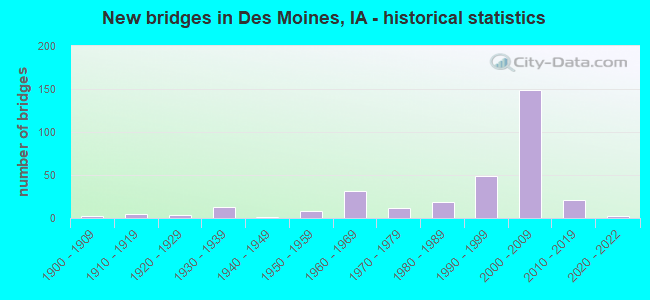
- New bridges - historical statistics
- 21900-1909
- 51910-1919
- 31920-1929
- 131930-1939
- 11940-1949
- 81950-1959
- 311960-1969
- 121970-1979
- 191980-1989
- 491990-1999
- 1492000-2009
- 212010-2019
- 22020-2022
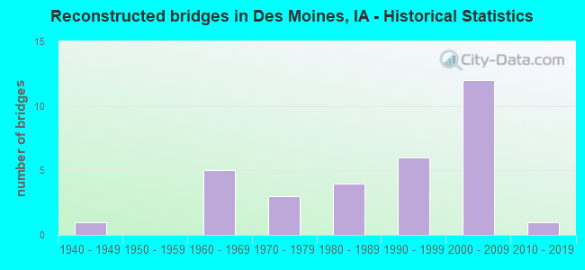
- Reconstructed bridges - Historical Statistics
- 11940-1949
- 01950-1959
- 51960-1969
- 31970-1979
- 41980-1989
- 61990-1999
- 122000-2009
- 12010-2019
- Bridge Condition - Deck
- 0.5%Excellent
- 29.8%Very good
- 38.8%Good
- 18.1%Satisfactory
- 7.4%Fair
- 2.1%Poor
- 2.1%Serious
- 1.1%Failed
- Bridge Condition - Superstructure
- 0.5%Excellent
- 36.7%Very good
- 34.6%Good
- 16.0%Satisfactory
- 6.4%Fair
- 2.7%Poor
- 2.1%Serious
- 1.1%Failed
- Bridge Condition - Substructure
- 1.1%Excellent
- 41.5%Very good
- 34.6%Good
- 6.4%Satisfactory
- 10.1%Fair
- 3.7%Poor
- 1.6%Serious
- 1.1%Failed
- Bridge Condition - Channel
- 2.8%Excellent
- 22.6%Very good
- 34.9%Good
- 24.5%Satisfactory
- 11.3%Fair
- 1.9%Poor
- 1.9%Serious
- 0.9%Failed
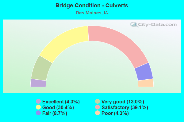
- Bridge Condition - Culverts
- 4.3%Excellent
- 13.0%Very good
- 30.4%Good
- 39.1%Satisfactory
- 8.7%Fair
- 4.3%Poor
Find on map >> Show street view
Structure Number: 50452, Location: At Jct. I-235 (Lat: 41.627719, Lng: -93.575664), Route carried "under" structure: Ramp Interstate 235, Year Built: 2003, Structure Length: 0. m, Average Daily Traffic: 3,150 (year 2020), Truck Traffic: 7%, Features Intersected: I-235, Facility Carried by Structure: US 6
Minimum Vertical Clearance: 30+ m (98+ ft), Kilometerpoint: 0.510, Lanes on structure: 6, Lanes under structure: 8, Material/Design: Steel continuous, Design/Construction: Stringer/Multi-beam, Length of Maximum Span: 49.7m (163.1ft)
Find on map >> Show street view
Structure Number: 50452, Location: At Jct. I-235 (Lat: 41.627719, Lng: -93.575664), Route carried "under" structure: Ramp Interstate 235, Year Built: 2003, Structure Length: 0. m, Average Daily Traffic: 1,890 (year 2020), Truck Traffic: 32%, Features Intersected: I-235, Facility Carried by Structure: US 6
Minimum Vertical Clearance: 30+ m (98+ ft), Kilometerpoint: 0.575, Lanes on structure: 6, Lanes under structure: 8, Material/Design: Steel continuous, Design/Construction: Stringer/Multi-beam, Length of Maximum Span: 49.7m (163.1ft)
Find on map >> Show street view
Structure Number: 504625, Location: 3.6 MILES E OF JCT IA 28 (Lat: 41.596472, Lng: -93.635736), Route carried "under" structure: City street , Year Built: 2004, Structure Length: 0. m, Average Daily Traffic: 4,460 (year 2018), Features Intersected: KEO WAY, Facility Carried by Structure: 19TH ST RAMP
Minimum Vertical Clearance: 30+ m (98+ ft), Kilometerpoint: 0.922, Lanes on structure: 3, Lanes under structure: 5, Material/Design: Steel continuous, Design/Construction: Stringer/Multi-beam, Length of Maximum Span: 51.2m (168.0ft)
Find on map >> Show street view
Structure Number: 504635, Location: 078240800 (Lat: 41.584428, Lng: -93.645097), Route carried "under" structure: City street , Year Built: 2004, Structure Length: 0. m, Average Daily Traffic: 18,400 (year 2016), Features Intersected: MLK PKWY, Facility Carried by Structure: GRAND AVENUE
Minimum Vertical Clearance: 30+ m (98+ ft), Kilometerpoint: 0.956, Lanes on structure: 4, Lanes under structure: 6, Material/Design: Concrete, Design/Construction: Frame, Length of Maximum Span: 38.7m (127.0ft)
Find on map >> Show street view
Structure Number: 50474, Location: 000000000 (Lat: 41.580683, Lng: -93.644733), Route carried "under" structure: City street , Year Built: 2004, Structure Length: 0. m, Average Daily Traffic: 1,550 (year 2016), Features Intersected: RACOON RIVER, FLEUR, RR, Facility Carried by Structure: MLK JR PKWY N
Minimum Vertical Clearance: 30+ m (98+ ft), Kilometerpoint: 0.555, Lanes on structure: 3, Lanes under structure: 1, Material/Design: Prestressed concrete, Design/Construction: Stringer/Multi-beam, Length of Maximum Span: 43.0m (141.1ft)
Find on map >> Show street view
Structure Number: 504745, Location: 078240800 (Lat: 41.583147, Lng: -93.644889), Route carried "under" structure: City street , Year Built: 2004, Structure Length: 0. m, Average Daily Traffic: 1,550 (year 2016), Features Intersected: RACOON RIVER, FLEUR, RR, Facility Carried by Structure: MLK JR PKWY S
Minimum Vertical Clearance: 30+ m (98+ ft), Kilometerpoint: 0.576, Lanes on structure: 3, Lanes under structure: 1, Material/Design: Prestressed concrete, Design/Construction: Stringer/Multi-beam, Length of Maximum Span: 43.0m (141.1ft)
Find on map >> Show street view
Structure Number: 50475, Location: 078240800 (Lat: 41.580044, Lng: -93.643706), Route carried "under" structure: City street , Year Built: 2004, Structure Length: 0. m, Average Daily Traffic: 3,000 (year 2016), Features Intersected: NB FLEUR RAMP, Facility Carried by Structure: MLK JR PKWY E/W
Minimum Vertical Clearance: 30+ m (98+ ft), Kilometerpoint: 9.553, Lanes on structure: 5, Lanes under structure: 1, Material/Design: Prestressed concrete, Design/Construction: Stringer/Multi-beam, Length of Maximum Span: 36.3m (119.1ft)
Find on map >> Show street view
Structure Number: 60109, Location: AT WEST JUNCTION I-80 (Lat: 41.659728, Lng: -93.521211), Route carried "under" structure: Interstate 80, Year Built: 1992, Structure Length: 0. m, Average Daily Traffic: 25,450 (year 2020), Truck Traffic: 19%, Features Intersected: I-80, Facility Carried by Structure: NB US 65
Minimum Vertical Clearance: 30+ m (98+ ft), Kilometerpoint: 225.915, Lanes on structure: 1, Lanes under structure: 7, Material/Design: Steel continuous, Design/Construction: Stringer/Multi-beam, Length of Maximum Span: 30.5m (100.1ft)
Find on map >> Show street view
Structure Number: 6011, Location: AT WEST JUNCTION OF I-80 (Lat: 41.660256, Lng: -93.522158), Route carried "under" structure: Interstate 80, Year Built: 1992, Structure Length: 0. m, Average Daily Traffic: 25,450 (year 2020), Truck Traffic: 19%, Features Intersected: I-80, Facility Carried by Structure: SB US 65
Minimum Vertical Clearance: 30+ m (98+ ft), Kilometerpoint: 225.886, Lanes on structure: 1, Lanes under structure: 7, Material/Design: Steel continuous, Design/Construction: Stringer/Multi-beam, Length of Maximum Span: 31.1m (102.0ft)
Find on map >> Show street view
Structure Number: 60119, Location: 1.0 MILE S OF JCT. I-80 (Lat: 41.647697, Lng: -93.513064), Route carried "under" structure: US 6, Year Built: 1993, Structure Length: 0. m, Average Daily Traffic: 3,450 (year 2020), Truck Traffic: 9%, Features Intersected: US 6
Minimum Vertical Clearance: 30+ m (98+ ft), Kilometerpoint: 238.735, Lanes on structure: 2, Lanes under structure: 5, Material/Design: Prestressed concrete, Design/Construction: Stringer/Multi-beam, Length of Maximum Span: 29.3m (96.1ft)
Find on map >> Show street view
Structure Number: 601356, Location: AT JUNCTION WITH US 69 (Lat: 41.596789, Lng: -93.595950), Route carried "under" structure: US 69, Year Built: 2005, Structure Length: 0. m, Average Daily Traffic: 7,500 (year 2020), Truck Traffic: 3%, Features Intersected: 15TH STREET, Facility Carried by Structure: WB I-235
Minimum Vertical Clearance: 30+ m (98+ ft), Kilometerpoint: 139.432, Lanes on structure: 4, Lanes under structure: 4, Material/Design: Steel continuous, Design/Construction: Stringer/Multi-beam, Length of Maximum Span: 26.2m (86.0ft)
Find on map >> Show street view
Structure Number: 601365, Location: 3.3 MILES S OF JCT I-80 (Lat: 41.618225, Lng: -93.493150), Route carried "under" structure: County highway , Year Built: 1994, Structure Length: 0. m, Average Daily Traffic: 1,285 (year 2016), Truck Traffic: 4%, Features Intersected: NE 27TH AVE & BIKE PATH, Facility Carried by Structure: US 65 NB
Minimum Vertical Clearance: 30+ m (98+ ft), Kilometerpoint: 0.723, Lanes on structure: 2, Lanes under structure: 2, Material/Design: Prestressed concrete, Design/Construction: Stringer/Multi-beam, Length of Maximum Span: 29.3m (96.1ft)
Find on map >> Show street view
Structure Number: 60137, Location: 3.3 MILES S OF JCT I-80 (Lat: 41.618808, Lng: -93.493350), Route carried "under" structure: County highway , Year Built: 1994, Structure Length: 0. m, Average Daily Traffic: 1,285 (year 2016), Truck Traffic: 4%, Features Intersected: NE 27TH AVE & BIKE PATH, Facility Carried by Structure: US 65 SB
Minimum Vertical Clearance: 30+ m (98+ ft), Kilometerpoint: 0.694, Lanes on structure: 2, Lanes under structure: 2, Material/Design: Prestressed concrete, Design/Construction: Stringer/Multi-beam, Length of Maximum Span: 29.3m (96.1ft)
Find on map >> Show street view
Structure Number: 601395, Location: 1.2 MILES S OF JCT I-80 (Lat: 41.644433, Lng: -93.510756), Route carried "under" structure: County highway , Year Built: 1994, Structure Length: 0. m, Average Daily Traffic: 4,200 (year 2016), Truck Traffic: 3%, Features Intersected: NE 46TH AVE, Facility Carried by Structure: SB US 65
Minimum Vertical Clearance: 30+ m (98+ ft), Kilometerpoint: 1.004, Lanes on structure: 2, Lanes under structure: 4, Material/Design: Steel continuous, Design/Construction: Stringer/Multi-beam, Length of Maximum Span: 46.3m (151.9ft)
Find on map >> Show street view
Structure Number: 601685, Location: 0.8 MILE S OF N JCT IA 5 (Lat: 41.511767, Lng: -93.538814), Route carried "under" structure: County highway , Year Built: 1997, Structure Length: 0. m, Average Daily Traffic: 105 (year 2016), Features Intersected: SE 38TH ST, Facility Carried by Structure: SB US 65
Minimum Vertical Clearance: 30+ m (98+ ft), Kilometerpoint: 0.084, Lanes on structure: 2, Lanes under structure: 2, Material/Design: Prestressed concrete, Design/Construction: Stringer/Multi-beam, Length of Maximum Span: 21.0m (68.9ft)
Find on map >> Show street view
Structure Number: 60169, Location: 0.8 MILE S OF N JCT IA 5 (Lat: 41.511547, Lng: -93.539433), Route carried "under" structure: County highway , Year Built: 1997, Structure Length: 0. m, Average Daily Traffic: 105 (year 2016), Features Intersected: SE 38TH ST, Facility Carried by Structure: NB US 65
Minimum Vertical Clearance: 30+ m (98+ ft), Kilometerpoint: 0.056, Lanes on structure: 2, Lanes under structure: 2, Material/Design: Prestressed concrete, Design/Construction: Stringer/Multi-beam, Length of Maximum Span: 21.0m (68.9ft)
Find on map >> Show street view
Structure Number: 60177, Location: AT JCT. OF US 65 & US 69 (Lat: 41.505900, Lng: -93.572358), Route carried "under" structure: US 69, Year Built: 1997, Structure Length: 0. m, Average Daily Traffic: 6,850 (year 2020), Truck Traffic: 4%, Features Intersected: NB 69-SB69-SB65, Facility Carried by Structure: SB IA 5/US 65
Minimum Vertical Clearance: 30+ m (98+ ft), Kilometerpoint: 128.117, Lanes on structure: 3, Lanes under structure: 6, Material/Design: Steel continuous, Design/Construction: Stringer/Multi-beam, Length of Maximum Span: 45.4m (149.0ft)
Find on map >> Show street view
Structure Number: 601935, Location: AT JCT OF US 65 & US 69 (Lat: 41.506344, Lng: -93.571567), Route carried "under" structure: US 69, Year Built: 1997, Structure Length: 0. m, Average Daily Traffic: 5,300 (year 2020), Truck Traffic: 3%, Features Intersected: US 69, Facility Carried by Structure: IA 5 NB US 65 SB
Minimum Vertical Clearance: 30+ m (98+ ft), Kilometerpoint: 128.152, Lanes on structure: 2, Lanes under structure: 4, Material/Design: Steel continuous, Design/Construction: Stringer/Multi-beam, Length of Maximum Span: 45.4m (149.0ft)
Find on map >> Show street view
Structure Number: 606755, Location: AT N JCT. OF IA 5 (Lat: 41.511675, Lng: -93.524983), Route carried "under" structure: State highway 5, Year Built: 1997, Structure Length: 0. m, Average Daily Traffic: 3,750 (year 2020), Truck Traffic: 6%, Features Intersected: IA 5
Minimum Vertical Clearance: 30+ m (98+ ft), Kilometerpoint: 144.630, Lanes on structure: 2, Lanes under structure: 2, Material/Design: Steel continuous, Design/Construction: Stringer/Multi-beam, Length of Maximum Span: 42.4m (139.1ft)
Find on map >> Show street view
Structure Number: 60676, Location: AT N JCT. OF IA 5 (Lat: 41.512172, Lng: -93.524344), Route carried "under" structure: Ramp State highway 5, Year Built: 1997, Structure Length: 0. m, Average Daily Traffic: 1,810 (year 2020), Truck Traffic: 4%, Features Intersected: IA 5
Minimum Vertical Clearance: 30+ m (98+ ft), Kilometerpoint: 144.662, Lanes on structure: 3, Lanes under structure: 2, Material/Design: Steel continuous, Design/Construction: Stringer/Multi-beam, Length of Maximum Span: 43.3m (142.1ft)
Find on map >> Show street view
Structure Number: 606775, Location: 1.0 MILE N OF N JCT IA 5 (Lat: 41.524464, Lng: -93.519339), Route carried "under" structure: County highway , Year Built: 1997, Structure Length: 0. m, Average Daily Traffic: 2,710 (year 2016), Truck Traffic: 4%, Features Intersected: SE 64TH AVE, Facility Carried by Structure: NB US 65
Minimum Vertical Clearance: 30+ m (98+ ft), Kilometerpoint: 0.229, Lanes on structure: 3, Lanes under structure: 5, Material/Design: Steel continuous, Design/Construction: Stringer/Multi-beam, Length of Maximum Span: 43.3m (142.1ft)
Find on map >> Show street view
Structure Number: 606775, Location: 1.0 MILE N OF N JCT IA 5 (Lat: 41.524464, Lng: -93.519339), Route carried "under" structure: Ramp US 65, Year Built: 1997, Structure Length: 0. m, Average Daily Traffic: 1,105 (year 2020), Truck Traffic: 5%, Features Intersected: SE 64TH AVE
Minimum Vertical Clearance: 30+ m (98+ ft), Kilometerpoint: 0.119, Lanes on structure: 3, Lanes under structure: 5, Material/Design: Steel continuous, Design/Construction: Stringer/Multi-beam, Length of Maximum Span: 43.3m (142.1ft)
Find on map >> Show street view
Structure Number: 60678, Location: 1.0 MI. N OF JCT. IA 5 (Lat: 41.525289, Lng: -93.519617), Route carried "under" structure: County highway , Year Built: 1997, Structure Length: 0. m, Average Daily Traffic: 2,710 (year 2016), Truck Traffic: 4%, Features Intersected: SE 64TH AVE, Facility Carried by Structure: SB US 65
Minimum Vertical Clearance: 30+ m (98+ ft), Kilometerpoint: 0.201, Lanes on structure: 2, Lanes under structure: 5, Material/Design: Steel continuous, Design/Construction: Stringer/Multi-beam, Length of Maximum Span: 43.3m (142.1ft)
Find on map >> Show street view
Structure Number: 60699, Location: 2.1 MILES S OF JCT IA 28 (Lat: 41.507017, Lng: -93.644925), Route carried "under" structure: State highway 5, Year Built: 2000, Structure Length: 0. m, Average Daily Traffic: 10,950 (year 2020), Truck Traffic: 9%, Features Intersected: IA 5, Facility Carried by Structure: FLEUR DR
Minimum Vertical Clearance: 30+ m (98+ ft), Kilometerpoint: 155.294, Lanes on structure: 3, Lanes under structure: 6, Material/Design: Prestressed concrete, Design/Construction: Stringer/Multi-beam, Length of Maximum Span: 36.9m (121.1ft)
Find on map >> Show street view
Structure Number: 606995, Location: 2.1 MI. S OF S JCT. IA 28 (Lat: 41.508097, Lng: -93.645067), Route carried "under" structure: State highway 5, Year Built: 2000, Structure Length: 0. m, Average Daily Traffic: 10,950 (year 2020), Truck Traffic: 9%, Features Intersected: IA 5, Facility Carried by Structure: FLEUR DR
Minimum Vertical Clearance: 30+ m (98+ ft), Kilometerpoint: 155.311, Lanes on structure: 2, Lanes under structure: 4, Material/Design: Prestressed concrete, Design/Construction: Stringer/Multi-beam, Length of Maximum Span: 36.9m (121.1ft)
Find on map >> Show street view
Structure Number: 60722, Location: 1.4 mi. S of IA 28 (Lat: 41.511294, Lng: -93.654000), Route carried "under" structure: State highway 5, Year Built: 2000, Structure Length: 0. m, Average Daily Traffic: 22,800 (year 2020), Truck Traffic: 9%, Features Intersected: IA 5, Facility Carried by Structure: COUNTY LINE RD
Minimum Vertical Clearance: 30+ m (98+ ft), Kilometerpoint: 156.069, Lanes on structure: 2, Lanes under structure: 5, Material/Design: Steel continuous, Design/Construction: Stringer/Multi-beam, Length of Maximum Span: 53.6m (175.9ft)
Find on map >> Show street view
Structure Number: 60728, Location: 2.9 mi. N of Jct. US 69 (Lat: 41.498928, Lng: -93.626364), Route carried "under" structure: City street , Year Built: 2000, Structure Length: 0. m, Average Daily Traffic: 3,550 (year 2016), Features Intersected: SR R63 (SW 9TH), Facility Carried by Structure: SB IA 5
Minimum Vertical Clearance: 30+ m (98+ ft), Kilometerpoint: 0.843, Lanes on structure: 2, Lanes under structure: 2, Material/Design: Steel continuous, Design/Construction: Stringer/Multi-beam, Length of Maximum Span: 40.2m (131.9ft)
Find on map >> Show street view
Structure Number: 607285, Location: 2.9 mi. N of Jct. US 69 (Lat: 41.498803, Lng: -93.625153), Route carried "under" structure: City street , Year Built: 2000, Structure Length: 0. m, Average Daily Traffic: 3,550 (year 2016), Features Intersected: SR R63 (SW 9TH), Facility Carried by Structure: NB IA 5
Minimum Vertical Clearance: 30+ m (98+ ft), Kilometerpoint: 0.874, Lanes on structure: 2, Lanes under structure: 2, Material/Design: Steel continuous, Design/Construction: Stringer/Multi-beam, Length of Maximum Span: 40.2m (131.9ft)
Find on map >> Show street view
Structure Number: 607525, Location: 2.3 mi. W of Jct. U.S. 69 (Lat: 41.497903, Lng: -93.616122), Route carried "under" structure: State highway 5, Year Built: 1998, Structure Length: 0. m, Average Daily Traffic: 21,300 (year 2020), Truck Traffic: 10%, Features Intersected: IA 5, Facility Carried by Structure: CLOVERHILL ST
Minimum Vertical Clearance: 30+ m (98+ ft), Kilometerpoint: 152.612, Lanes on structure: 2, Lanes under structure: 4, Material/Design: Prestressed concrete, Design/Construction: Stringer/Multi-beam, Length of Maximum Span: 36.9m (121.1ft)
Find on map >> Show street view
Structure Number: 60782, Location: At Jct. IA 28 (Lat: 41.514150, Lng: -93.681183), Route carried "under" structure: State highway 28, Year Built: 2000, Structure Length: 0. m, Average Daily Traffic: 7,950 (year 2020), Truck Traffic: 3%, Features Intersected: IA 28, Facility Carried by Structure: IA 5 NB
Minimum Vertical Clearance: 30+ m (98+ ft), Kilometerpoint: 18.223, Lanes on structure: 3, Lanes under structure: 6, Material/Design: Prestressed concrete, Design/Construction: Stringer/Multi-beam, Length of Maximum Span: 41.5m (136.2ft)
Find on map >> Show street view
Structure Number: 607825, Location: At Jct. IA 28 (Lat: 41.513861, Lng: -93.682525), Route carried "under" structure: State highway 28, Year Built: 2000, Structure Length: 0. m, Average Daily Traffic: 6,650 (year 2020), Truck Traffic: 4%, Features Intersected: IA 28, Facility Carried by Structure: IA 5 SB
Minimum Vertical Clearance: 30+ m (98+ ft), Kilometerpoint: 18.176, Lanes on structure: 3, Lanes under structure: 6, Material/Design: Prestressed concrete, Design/Construction: Stringer/Multi-beam, Length of Maximum Span: 41.5m (136.2ft)
Find on map >> Show street view
Structure Number: 60797, Location: 0.2 MILE E OF JCT IA 415 (Lat: 41.649131, Lng: -93.615331), Route carried "under" structure: County highway , Year Built: 2000, Structure Length: 0. m, Average Daily Traffic: 2,540 (year 2016), Features Intersected: NE 3RD ST, Facility Carried by Structure: I-80 EB ON RAMP
Minimum Vertical Clearance: 30+ m (98+ ft), Kilometerpoint: 1.373, Lanes on structure: 1, Lanes under structure: 2, Material/Design: Prestressed concrete, Design/Construction: Stringer/Multi-beam, Length of Maximum Span: 36.6m (120.1ft)
Find on map >> Show street view
Structure Number: 608215, Location: 0.2 MILE E OF JCT IA 415 (Lat: 41.649797, Lng: -93.614917), Route carried "under" structure: County highway , Year Built: 2000, Structure Length: 0. m, Average Daily Traffic: 2,540 (year 2016), Features Intersected: NE 3RD ST, Facility Carried by Structure: I 80 WB OFF RAMP
Minimum Vertical Clearance: 30+ m (98+ ft), Kilometerpoint: 1.445, Lanes on structure: 1, Lanes under structure: 2, Material/Design: Prestressed concrete, Design/Construction: Stringer/Multi-beam, Length of Maximum Span: 36.6m (120.1ft)
Find on map >> Show street view
Structure Number: 608565, Location: 3.2 mi. E of Jct. IA #28 (Lat: 41.596347, Lng: -93.644283), Route carried "under" structure: Interstate 235, Year Built: 2003, Structure Length: 0. m, Average Daily Traffic: 86,600 (year 2020), Truck Traffic: 7%, Features Intersected: I-235, Facility Carried by Structure: M LUTHER KING
Minimum Vertical Clearance: 30+ m (98+ ft), Kilometerpoint: 11.922, Lanes on structure: 3, Lanes under structure: 10, Material/Design: Steel continuous, Design/Construction: Stringer/Multi-beam, Length of Maximum Span: 44.5m (146.0ft)
Find on map >> Show street view
Structure Number: 60857, Location: 0.4 mi. E of Jct. IA #163 (Lat: 41.604342, Lng: -93.579856), Route carried "under" structure: City street , Year Built: 2006, Structure Length: 0. m, Average Daily Traffic: 1,680 (year 2018), Features Intersected: EASTON BLVD, Facility Carried by Structure: I-235 WB
Minimum Vertical Clearance: 30+ m (98+ ft), Kilometerpoint: 0.816, Lanes on structure: 3, Lanes under structure: 2, Material/Design: Steel, Design/Construction: Stringer/Multi-beam, Length of Maximum Span: 53.3m (174.9ft)
Find on map >> Show street view
Structure Number: 60868, Location: 4.9 mi. E of Jct. IA #28 (Lat: 41.595497, Lng: -93.610094), Route carried "under" structure: Interstate 235, Year Built: 2002, Structure Length: 0. m, Average Daily Traffic: 70,900 (year 2020), Truck Traffic: 8%, Features Intersected: I-235, Facility Carried by Structure: E 6TH ST
Minimum Vertical Clearance: 30+ m (98+ ft), Kilometerpoint: 14.754, Lanes on structure: 3, Lanes under structure: 8, Material/Design: Steel continuous, Design/Construction: Stringer/Multi-beam, Length of Maximum Span: 45.1m (148.0ft)
Find on map >> Show street view
Structure Number: 60876, Location: 0.9 MI. E OF JCT. US 69 (Lat: 41.603114, Lng: -93.580914), Route carried "under" structure: City street , Year Built: 2001, Structure Length: 0. m, Average Daily Traffic: 3,300 (year 2012), Features Intersected: EAST 21ST STREET, Facility Carried by Structure: WB I-235
Minimum Vertical Clearance: 30+ m (98+ ft), Kilometerpoint: 0.972, Lanes on structure: 4, Lanes under structure: 2, Material/Design: Prestressed concrete, Design/Construction: Stringer/Multi-beam, Length of Maximum Span: 27.4m (89.9ft)
Find on map >> Show street view
Structure Number: 60895, Location: 4.2 mi. E of Jct. IA #28 (Lat: 41.595364, Lng: -93.624650), Route carried "under" structure: Interstate 235, Year Built: 2003, Structure Length: 0. m, Average Daily Traffic: 73,400 (year 2020), Truck Traffic: 8%, Features Intersected: I-235, Facility Carried by Structure: 5TH AVE
Minimum Vertical Clearance: 30+ m (98+ ft), Kilometerpoint: 13.567, Lanes on structure: 3, Lanes under structure: 8, Material/Design: Steel continuous, Design/Construction: Stringer/Multi-beam, Length of Maximum Span: 44.8m (147.0ft)
Find on map >> Show street view
Structure Number: 609045, Location: 0.3 mi. E of Jct. IA 163 (Lat: 41.602519, Lng: -93.580831), Route carried "under" structure: City street , Year Built: 2006, Structure Length: 0. m, Average Daily Traffic: 6,600 (year 2012), Features Intersected: EAST 21ST STREET, Facility Carried by Structure: I 235 EB OFF RAMP
Minimum Vertical Clearance: 30+ m (98+ ft), Kilometerpoint: 0.917, Lanes on structure: 1, Lanes under structure: 2, Material/Design: Prestressed concrete, Design/Construction: Stringer/Multi-beam, Length of Maximum Span: 9.1m (29.9ft)
Find on map >> Show street view
Structure Number: 609255, Location: 0.3 MILE E OF JCT US 69 (Lat: 41.598006, Lng: -93.589775), Route carried "under" structure: Ramp Interstate 235, Year Built: 2004, Structure Length: 0. m, Average Daily Traffic: 6,500 (year 2020), Truck Traffic: 8%, Features Intersected: E UNIVERSITY RAMP B, Facility Carried by Structure: E 15TH RAMP D
Minimum Vertical Clearance: 30+ m (98+ ft), Kilometerpoint: 0.381, Lanes on structure: 2, Lanes under structure: 2, Material/Design: Steel continuous, Design/Construction: Stringer/Multi-beam, Length of Maximum Span: 75.3m (247.0ft)
Find on map >> Show street view
Structure Number: 60926, Location: 0.6 MI E OF JCT US 69 NB (Lat: 41.601192, Lng: -93.584331), Route carried "under" structure: State highway 163, Year Built: 2004, Structure Length: 0. m, Average Daily Traffic: 4,400 (year 2020), Truck Traffic: 5%, Features Intersected: IA 163/UNIV AVE/RAMP, Facility Carried by Structure: WB I-235
Minimum Vertical Clearance: 30+ m (98+ ft), Kilometerpoint: 1.165, Lanes on structure: 3, Lanes under structure: 5, Material/Design: Steel continuous, Design/Construction: Stringer/Multi-beam, Length of Maximum Span: 72.8m (238.8ft)
Find on map >> Show street view
Structure Number: 609365, Location: 0.5 mi. E of Jct. U.S. 69 (Lat: 41.600864, Lng: -93.586803), Route carried "under" structure: Ramp Interstate 235, Year Built: 2004, Structure Length: 0. m, Average Daily Traffic: 4,850 (year 2020), Truck Traffic: 8%, Features Intersected: WB EXIT RAMP, UNIV. AVE., Facility Carried by Structure: UNI AVE WB ENTR
Minimum Vertical Clearance: 30+ m (98+ ft), Kilometerpoint: 0.266, Lanes on structure: 1, Lanes under structure: 5, Material/Design: Steel continuous, Design/Construction: Stringer/Multi-beam, Length of Maximum Span: 59.4m (194.9ft)
Find on map >> Show street view
Structure Number: 609365, Location: 0.5 mi. E of Jct. U.S. 69 (Lat: 41.600864, Lng: -93.586803), Route carried "under" structure: State highway 163, Year Built: 2004, Structure Length: 0. m, Average Daily Traffic: 8,800 (year 2020), Truck Traffic: 5%, Features Intersected: WB EXIT RAMP, UNIV. AVE., Facility Carried by Structure: UNI AVE WB ENTR
Minimum Vertical Clearance: 30+ m (98+ ft), Kilometerpoint: 1.088, Lanes on structure: 1, Lanes under structure: 5, Material/Design: Steel continuous, Design/Construction: Stringer/Multi-beam, Length of Maximum Span: 59.4m (194.9ft)
Find on map >> Show street view
Structure Number: 609395, Location: 0.4 mi. E of Jct. IA #163 (Lat: 41.604025, Lng: -93.579792), Route carried "under" structure: City street , Year Built: 2004, Structure Length: 0. m, Average Daily Traffic: 1,680 (year 2018), Features Intersected: EASTON BLVD, Facility Carried by Structure: I 235 EB
Minimum Vertical Clearance: 30+ m (98+ ft), Kilometerpoint: 0.856, Lanes on structure: 3, Lanes under structure: 2, Material/Design: Steel, Design/Construction: Stringer/Multi-beam, Length of Maximum Span: 50.9m (167.0ft)
Find on map >> Show street view
Structure Number: 609695, Location: 3.8 mi. E of Jct. IA 28 (Lat: 41.595628, Lng: -93.632717), Route carried "under" structure: Ramp Interstate 235, Year Built: 2005, Structure Length: 0. m, Average Daily Traffic: 10,000 (year 2020), Truck Traffic: 2%, Features Intersected: KEO WAY RAMP TO EB I-235
Minimum Vertical Clearance: 30+ m (98+ ft), Kilometerpoint: 0.261, Lanes on structure: 2, Lanes under structure: 1, Material/Design: Steel continuous, Design/Construction: Stringer/Multi-beam, Length of Maximum Span: 60.4m (198.2ft)