Bridge Statistics for Dexter, Missouri (MO)
Condition, Traffic, Stress, Structural Evaluation, Project Costs
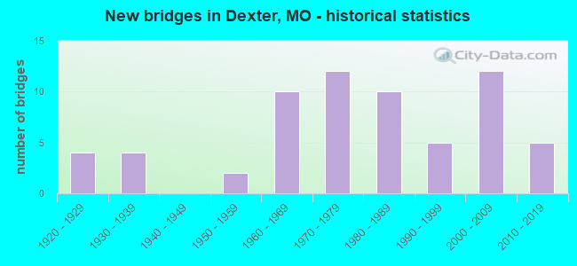
- New bridges - historical statistics
- 41920-1929
- 41930-1939
- 21950-1959
- 101960-1969
- 121970-1979
- 101980-1989
- 51990-1999
- 122000-2009
- 52010-2019
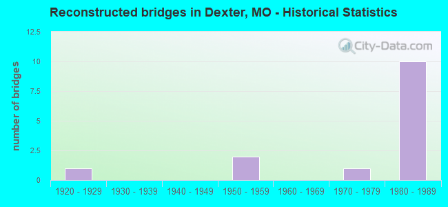
- Reconstructed bridges - Historical Statistics
- 11920-1929
- 01930-1939
- 01940-1949
- 21950-1959
- 01960-1969
- 11970-1979
- 101980-1989
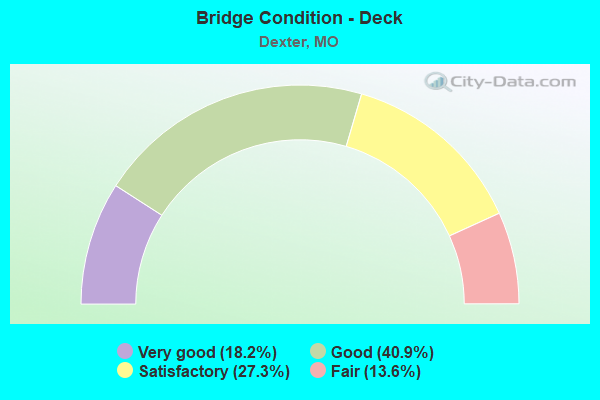
- Bridge Condition - Deck
- 18.2%Very good
- 40.9%Good
- 27.3%Satisfactory
- 13.6%Fair
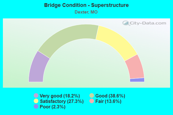
- Bridge Condition - Superstructure
- 18.2%Very good
- 38.6%Good
- 27.3%Satisfactory
- 13.6%Fair
- 2.3%Poor
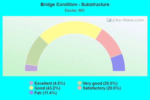
- Bridge Condition - Substructure
- 4.5%Excellent
- 20.5%Very good
- 43.2%Good
- 20.5%Satisfactory
- 11.4%Fair
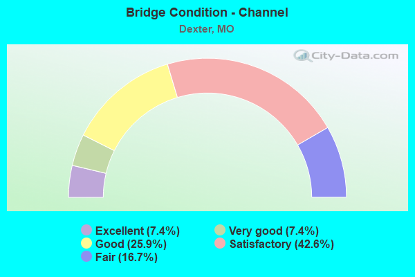
- Bridge Condition - Channel
- 7.4%Excellent
- 7.4%Very good
- 25.9%Good
- 42.6%Satisfactory
- 16.7%Fair
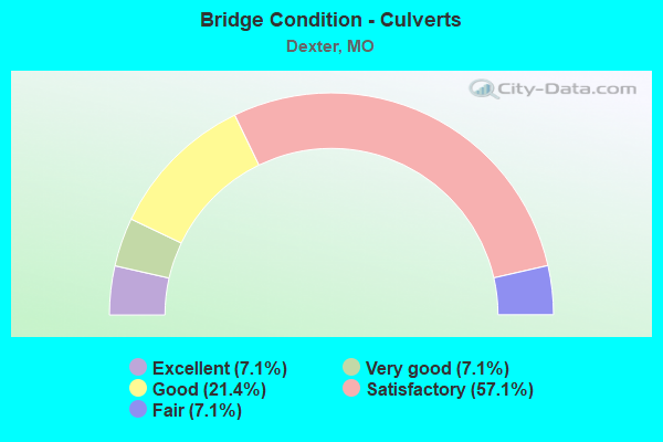
- Bridge Condition - Culverts
- 7.1%Excellent
- 7.1%Very good
- 21.4%Good
- 57.1%Satisfactory
- 7.1%Fair
Find on map >> Show street view
Structure Number: 33164, Location: S 19 T 25 N R 11 W (Lat: 36.787747, Lng: -89.906922), Route carried "on" structure: State highway 114, Year Built: 2010, Status: Open, Structure Length: 2.74m (8.99ft), Average Daily Traffic: 1,775 (year 2021), Truck Traffic: 17%, Average Future Daily Traffic: 2,485 (year 2041), Design Load: HS 20, Features Intersected: DRAIN DTCH
Minimum Vertical Clearance: 30+ m (98+ ft), Kilometerpoint: 32.856, Lanes on structure: 2, Owner: State Highway Agency, Approaching Roadway Width: 8.5m (27.9ft), Material/Design: Prestressed concrete, Design/Construction: Box Beam or Girders - Single/Spread, Number Of Spans In Main Unit: 1, Length of Maximum Span: 27.4m (89.9ft), Curb-To-Curb Width: 8.5m (27.9ft), Out-to-Out Width: 9.1m (29.9ft)
Condition: Deck: Satisfactory, Superstructure: Very good, Substructure: Excellent, Channel: Good, Operating Rating: 96.3 metric tons, Method Used To Determine Operating Rating: Load Factor (LF), Inventory Rating: 49.5 metric tons, Method Used To Determine Inventory Rating: Load Factor (LF), Structural Evaluation: Equal to present desirable criteria, Deck Geometry: Somewhat better than minimum adequacy, Waterway Adequacy: Superior to present desirable criteria, Approach Roadway Alignment: Equal to present desirable criteria, Designated Inspection Frequency: Every 24 months, Inspection Date: October 2021, Deck Structure Type: Concrete Cast-file-Place, Wearing Surface/Protective System: Wearing Surface: Monolithic Concrete, Deck Protection: Epoxy Coated Reinforcing
Find on map >> Show street view
Structure Number: 33758, Location: S 7 T 25 N R 10 E (Lat: 36.819458, Lng: -89.913214), Route carried "on" structure: US 60, Year Built: 2011, Status: Open, Structure Length: 1.83m (6.00ft), Average Daily Traffic: 7,127 (year 2021), Truck Traffic: 21%, Average Future Daily Traffic: 12,472 (year 2041), Design Load: HS 25 or greater, Features Intersected: LATERAL DTCH #2
Minimum Vertical Clearance: 30+ m (98+ ft), Kilometerpoint: 73.916, Lanes on structure: 2, Base Highway Network: Yes, Owner: State Highway Agency, Approaching Roadway Width: 11.6m (38.1ft), Material/Design: Prestressed concrete, Design/Construction: Box Beam or Girders - Single/Spread, Number Of Spans In Main Unit: 1, Length of Maximum Span: 18.3m (60.0ft), Curb-To-Curb Width: 11.6m (38.1ft), Out-to-Out Width: 12.2m (40.0ft)
Condition: Deck: Good, Superstructure: Good, Substructure: Very good, Channel: Good, Inventory Rating: 53.1 metric tons, Method Used To Determine Inventory Rating: Load Factor (LF), Structural Evaluation: Better than present minimum criteria, Deck Geometry: Better than present minimum criteria, Waterway Adequacy: Superior to present desirable criteria, Approach Roadway Alignment: Equal to present desirable criteria, Designated Inspection Frequency: Every 24 months, Inspection Date: October 2021, Deck Structure Type: Concrete Cast-file-Place, Wearing Surface/Protective System: Wearing Surface: Monolithic Concrete, Deck Protection: Epoxy Coated Reinforcing
Find on map >> Show street view
Structure Number: 34009, Location: S 21 T 25 N R 10 E (Lat: 36.789083, Lng: -89.980028), Route carried "on" structure: City street , Year Built: 2011, Status: Open, Structure Length: 0.67m (2.20ft), Average Daily Traffic: 10 (year 2021), Truck Traffic: 10%, Average Future Daily Traffic: 13 (year 2041), Features Intersected: DRAIN DTCH, Facility Carried by Structure: GRANT ST
Minimum Vertical Clearance: 30+ m (98+ ft), Kilometerpoint: 0.000, Lanes on structure: 2, Owner: City or Municipal Highway Agency, Approaching Roadway Width: 9.1m (29.9ft), Material/Design: Steel, Design/Construction: Culvert, Number Of Spans In Main Unit: 2, Length of Maximum Span: 2.9m (9.5ft), Curb-To-Curb Width: 6.7m (22.0ft), Out-to-Out Width: 6.7m (22.0ft)
Condition: Channel: Excellent, Culverts: Very good, Structural Evaluation: Equal to present desirable criteria, Deck Geometry: Somewhat better than minimum adequacy, Waterway Adequacy: Equal to present desirable criteria, Approach Roadway Alignment: Better than present minimum criteria, Designated Inspection Frequency: Every 24 months, Inspection Date: January 2021, Wearing Surface/Protective System: Wearing Surface: Bituminous
Find on map >> Show street view
Structure Number: 34425, Location: S 20 T 25 N R 10 E (Lat: 36.800139, Lng: -89.993500), Route carried "on" structure: City street , Year Built: 2002, Status: Open, Structure Length: 6.86m (22.51ft), Average Daily Traffic: 4,000 (year 2021), Truck Traffic: 10%, Average Future Daily Traffic: 5,400 (year 2041), Design Load: HS 20, Features Intersected: DULEY MAIN DTCH, Facility Carried by Structure: ARVIN RD
Minimum Vertical Clearance: 30+ m (98+ ft), Kilometerpoint: 0.241, Lanes on structure: 2, Owner: City or Municipal Highway Agency, Approaching Roadway Width: 9.1m (29.9ft), Skew: 6 degrees, Material/Design: Concrete continuous, Design/Construction: Box Beam or Girders - Multiple, Number Of Spans In Main Unit: 3, Length of Maximum Span: 22.9m (75.1ft), Curb-To-Curb Width: 9.0m (29.5ft), Out-to-Out Width: 9.1m (29.9ft)
Condition: Deck: Satisfactory, Superstructure: Satisfactory, Substructure: Very good, Channel: Very good, Operating Rating: 47.7 metric tons, Method Used To Determine Operating Rating: Load Factor (LF), Inventory Rating: 27.0 metric tons, Method Used To Determine Inventory Rating: Load Factor (LF), Structural Evaluation: Equal to present minimum criteria, Deck Geometry: Meets minimum limits, Waterway Adequacy: Superior to present desirable criteria, Approach Roadway Alignment: Equal to present minimum criteria, Designated Inspection Frequency: Every 24 months, Inspection Date: January 2021, Deck Structure Type: Other, Wearing Surface/Protective System: Wearing Surface: Bituminous
Find on map >> Show street view
Structure Number: 35304, Location: S 35 T 25 N R 10 E (Lat: 36.759444, Lng: -89.948056), Route carried "on" structure: County highway 154, Year Built: 2016, Status: Open, Structure Length: 2.29m (7.51ft), Average Daily Traffic: 35 (year 2021), Truck Traffic: 10%, Average Future Daily Traffic: 46 (year 2041), Design Load: HS 20, Features Intersected: DRAIN DTCH, Facility Carried by Structure: COUNTY RD 732
Minimum Vertical Clearance: 30+ m (98+ ft), Kilometerpoint: 1.448, Lanes on structure: 2, Owner: County Highway Agency, Approaching Roadway Width: 6.1m (20.0ft), Material/Design: Prestressed concrete, Design/Construction: Box Beam or Girders - Multiple, Number Of Spans In Main Unit: 1, Length of Maximum Span: 21.9m (71.9ft), Curb-To-Curb Width: 7.3m (24.0ft), Out-to-Out Width: 7.3m (24.0ft)
Condition: Deck: Very good, Superstructure: Very good, Substructure: Very good, Channel: Good, Operating Rating: 96.3 metric tons, Method Used To Determine Operating Rating: Load Factor (LF), Inventory Rating: 57.6 metric tons, Method Used To Determine Inventory Rating: Load Factor (LF), Structural Evaluation: Equal to present desirable criteria, Deck Geometry: Equal to present minimum criteria, Waterway Adequacy: Superior to present desirable criteria, Approach Roadway Alignment: Equal to present desirable criteria, Designated Inspection Frequency: Every 24 months, Inspection Date: January 2021, Deck Structure Type: Concrete Cast-file-Place, Wearing Surface/Protective System: Wearing Surface: Monolithic Concrete
Find on map >> Show street view
Structure Number: 3555, Location: S 4 T 25 N R 10 E (Lat: 36.840778, Lng: -89.968333), Route carried "on" structure: County highway 446, Year Built: 2016, Status: Open, Structure Length: 0.63m (2.07ft), Average Daily Traffic: 100 (year 2021), Truck Traffic: 10%, Average Future Daily Traffic: 130 (year 2041), Features Intersected: DELAWARE CR, Facility Carried by Structure: COUNTY RD 413
Minimum Vertical Clearance: 30+ m (98+ ft), Kilometerpoint: 0.644, Lanes on structure: 2, Owner: County Highway Agency, Approaching Roadway Width: 7.3m (24.0ft), Material/Design: Concrete, Design/Construction: Culvert, Number Of Spans In Main Unit: 2, Length of Maximum Span: 3.3m (10.8ft), Curb-To-Curb Width: 7.3m (24.0ft), Out-to-Out Width: 8.4m (27.6ft)
Condition: Channel: Excellent, Culverts: Excellent, Operating Rating: 45.9 metric tons, Method Used To Determine Operating Rating: Load Factor (LF), Inventory Rating: 27.0 metric tons, Method Used To Determine Inventory Rating: Load Factor (LF), Structural Evaluation: Equal to present minimum criteria, Deck Geometry: Equal to present minimum criteria, Waterway Adequacy: Superior to present desirable criteria, Approach Roadway Alignment: Equal to present desirable criteria, Designated Inspection Frequency: Every 24 months, Inspection Date: January 2021, Deck Structure Type: Concrete Cast-file-Place, Wearing Surface/Protective System: Wearing Surface: Bituminous
Find on map >> Show street view
Structure Number: 4541, Location: S 24 T 25 N R 10 E (Lat: 36.787869, Lng: -89.925706), Route carried "on" structure: State highway 114, Year Built: 1921, Year Reconstructed: 1932, Status: Open, Structure Length: 1.62m (5.31ft), Average Daily Traffic: 1,775 (year 2021), Truck Traffic: 14%, Average Future Daily Traffic: 2,485 (year 2041), Design Load: H 15, Features Intersected: DRAIN DTCH
Minimum Vertical Clearance: 30+ m (98+ ft), Kilometerpoint: 2.298, Lanes on structure: 2, Owner: State Highway Agency, Approaching Roadway Width: 6.1m (20.0ft), Skew: 2 degrees, Material/Design: Steel, Design/Construction: Stringer/Multi-beam, Number Of Spans In Main Unit: 1, Length of Maximum Span: 15.3m (50.2ft), Curb-To-Curb Width: 6.7m (22.0ft), Out-to-Out Width: 7.2m (23.6ft)
Condition: Deck: Fair, Superstructure: Fair, Substructure: Fair, Channel: Satisfactory, Operating Rating: 26.1 metric tons, Method Used To Determine Operating Rating: Load Factor (LF), Inventory Rating: 16.2 metric tons, Method Used To Determine Inventory Rating: Load Factor (LF), Structural Evaluation: Meets minimum limits, Deck Geometry: High priority of corrective action, Waterway Adequacy: Equal to present desirable criteria, Approach Roadway Alignment: Equal to present desirable criteria, Length Of Structure Improvement: 0.23m (0.75ft), Designated Inspection Frequency: Every 24 months, Inspection Date: October 2021, Bridge Improvement Cost: $288,000, Roadway Improvement Cost: $29,000, Total Project Cost: $432,000 ( Estimate for 2022), Deck Structure Type: Concrete Cast-file-Place, Wearing Surface/Protective System: Wearing Surface: Bituminous, Deck Protection: Internally Sealed
Find on map >> Show street view
Structure Number: 4584, Location: S 10 T 24 N R 10 E (Lat: 36.731069, Lng: -89.965150), Route carried "on" structure: State highway 25, Year Built: 1922, Year Reconstructed: 1955, Status: Open, Structure Length: 0.64m (2.10ft), Average Daily Traffic: 6,561 (year 2021), Truck Traffic: 10%, Average Future Daily Traffic: 11,154 (year 2041), Design Load: H 20, Features Intersected: MILLER DTCH
Minimum Vertical Clearance: 30+ m (98+ ft), Kilometerpoint: 86.752, Lanes on structure: 2, Base Highway Network: Yes, Owner: State Highway Agency, Approaching Roadway Width: 9.8m (32.2ft), Material/Design: Concrete continuous, Design/Construction: Culvert, Number Of Spans In Main Unit: 2, Length of Maximum Span: 3.0m (9.8ft)
Condition: Channel: Satisfactory, Culverts: Good, Operating Rating: 78.3 metric tons, Method Used To Determine Operating Rating: Load Factor (LF), Inventory Rating: 46.8 metric tons, Method Used To Determine Inventory Rating: Load Factor (LF), Structural Evaluation: Better than present minimum criteria, Waterway Adequacy: Equal to present desirable criteria, Approach Roadway Alignment: Equal to present desirable criteria, Designated Inspection Frequency: Every 24 months, Inspection Date: October 2021
Find on map >> Show street view
Structure Number: 51, Location: S 14 T 25 N R 10 E (Lat: 36.814736, Lng: -89.947603), Route carried "on" structure: US 60, Year Built: 1960, Status: Open, Structure Length: 1.22m (4.00ft), Average Daily Traffic: 13,999 (year 2021), Truck Traffic: 20%, Average Future Daily Traffic: 24,498 (year 2041), Design Load: H 20, Features Intersected: DEXTER CR
Minimum Vertical Clearance: 30+ m (98+ ft), Kilometerpoint: 472.163, Lanes on structure: 2, Base Highway Network: Yes, Owner: State Highway Agency, Approaching Roadway Width: 32.9m (107.9ft), Skew: 2 degrees, Material/Design: Concrete continuous, Design/Construction: Culvert, Number Of Spans In Main Unit: 3, Length of Maximum Span: 3.7m (12.1ft)
Condition: Channel: Fair, Culverts: Satisfactory, Operating Rating: 72.0 metric tons, Method Used To Determine Operating Rating: Field evaluation and documented engineering judgment, Inventory Rating: 43.2 metric tons, Method Used To Determine Inventory Rating: Field evaluation and documented engineering judgment, Structural Evaluation: Equal to present minimum criteria, Waterway Adequacy: Equal to present desirable criteria, Approach Roadway Alignment: Equal to present desirable criteria, Designated Inspection Frequency: Every 24 months, Inspection Date: October 2021
Find on map >> Show street view
Structure Number: 551, Location: S 16 T 25 N R 10 E (Lat: 36.808022, Lng: -89.975142), Route carried "on" structure: US 60, Year Built: 1960, Year Reconstructed: 1987, Status: Open, Structure Length: 0.98m (3.22ft), Average Daily Traffic: 13,804 (year 2021), Truck Traffic: 22%, Average Future Daily Traffic: 24,157 (year 2041), Design Load: H 20, Features Intersected: DEXTER CR
Minimum Vertical Clearance: 30+ m (98+ ft), Kilometerpoint: 469.595, Lanes on structure: 4, Base Highway Network: Yes, Owner: State Highway Agency, Approaching Roadway Width: 39.0m (128.0ft), Skew: 5 degrees, Material/Design: Concrete continuous, Design/Construction: Culvert, Number Of Spans In Main Unit: 2, Length of Maximum Span: 3.0m (9.8ft)
Condition: Channel: Satisfactory, Culverts: Good, Operating Rating: 44.1 metric tons, Method Used To Determine Operating Rating: Load Factor (LF), Inventory Rating: 26.1 metric tons, Method Used To Determine Inventory Rating: Load Factor (LF), Structural Evaluation: Equal to present minimum criteria, Waterway Adequacy: Equal to present desirable criteria, Approach Roadway Alignment: Equal to present desirable criteria, Designated Inspection Frequency: Every 24 months, Inspection Date: October 2021
Find on map >> Show street view
Structure Number: 5635, Location: S 23 T 25 N R 10 E (Lat: 36.791692, Lng: -89.949744), Route carried "on" structure: State highway 25, Year Built: 1934, Year Reconstructed: 1964, Status: Open, Structure Length: 1.20m (3.94ft), Average Daily Traffic: 7,040 (year 2021), Truck Traffic: 10%, Average Future Daily Traffic: 11,968 (year 2041), Design Load: H 20, Features Intersected: DEXTER CR
Minimum Vertical Clearance: 30+ m (98+ ft), Kilometerpoint: 79.647, Lanes on structure: 4, Owner: State Highway Agency, Approaching Roadway Width: 25.6m (84.0ft), Skew: 21 degrees, Material/Design: Concrete continuous, Design/Construction: Culvert, Number Of Spans In Main Unit: 3, Length of Maximum Span: 3.7m (12.1ft)
Condition: Channel: Fair, Culverts: Satisfactory, Operating Rating: 45.9 metric tons, Method Used To Determine Operating Rating: Load Factor (LF), Inventory Rating: 27.9 metric tons, Method Used To Determine Inventory Rating: Load Factor (LF), Structural Evaluation: Equal to present minimum criteria, Waterway Adequacy: Equal to present desirable criteria, Approach Roadway Alignment: Equal to present desirable criteria, Designated Inspection Frequency: Every 24 months, Inspection Date: October 2021
Find on map >> Show street view
Structure Number: 5636, Location: S 23 T 25 N R 10 E (Lat: 36.788550, Lng: -89.947406), Route carried "on" structure: State highway 114, Year Built: 1934, Status: Open, Structure Length: 4.72m (15.49ft), Average Daily Traffic: 2,674 (year 2021), Truck Traffic: 14%, Average Future Daily Traffic: 4,546 (year 2041), Design Load: H 15, Features Intersected: DEXTER CR
Minimum Vertical Clearance: 30+ m (98+ ft), Kilometerpoint: 0.323, Lanes on structure: 2, Owner: State Highway Agency, Approaching Roadway Width: 8.5m (27.9ft), Skew: 1 degrees, Material/Design: Concrete, Design/Construction: Tee Beam, Number Of Spans In Main Unit: 4, Length of Maximum Span: 11.8m (38.7ft), Curb-To-Curb Width: 9.1m (29.9ft), Out-to-Out Width: 10.1m (33.1ft)
Condition: Deck: Fair, Superstructure: Poor, Substructure: Fair, Channel: Satisfactory, Operating Rating: 69.3 metric tons, Method Used To Determine Operating Rating: Load Factor (LF), Inventory Rating: 41.4 metric tons, Method Used To Determine Inventory Rating: Load Factor (LF), Structural Evaluation: Meets minimum limits, Deck Geometry: Meets minimum limits, Waterway Adequacy: Equal to present desirable criteria, Approach Roadway Alignment: High priority of corrective action, Length Of Structure Improvement: 0.57m (1.87ft), Designated Inspection Frequency: Every 24 months, Inspection Date: October 2021, Bridge Improvement Cost: $488,000, Roadway Improvement Cost: $49,000, Total Project Cost: $732,000 ( Estimate for 2022), Deck Structure Type: Concrete Cast-file-Place, Wearing Surface/Protective System: Wearing Surface: Bituminous, Membrane: Built-up
Find on map >> Show street view
Structure Number: 5637, Location: S 23 T 23 N R 10 E (Lat: 36.789183, Lng: -89.948872), Route carried "on" structure: State highway 114, Year Built: 1934, Status: Open, Structure Length: 4.27m (14.01ft), Average Daily Traffic: 2,674 (year 2021), Truck Traffic: 14%, Average Future Daily Traffic: 4,546 (year 2041), Design Load: H 15, Features Intersected: UP RR
Minimum Vertical Clearance: 30+ m (98+ ft), Kilometerpoint: 0.177, Lanes on structure: 2, Owner: State Highway Agency, Approaching Roadway Width: 12.2m (40.0ft), Material/Design: Concrete, Design/Construction: Tee Beam, Number Of Spans In Main Unit: 3, Length of Maximum Span: 14.2m (46.6ft), Curb-To-Curb Width: 9.1m (29.9ft), Out-to-Out Width: 10.1m (33.1ft)
Condition: Deck: Fair, Superstructure: Fair, Substructure: Fair, Operating Rating: 62.1 metric tons, Method Used To Determine Operating Rating: Load Factor (LF), Inventory Rating: 36.9 metric tons, Method Used To Determine Inventory Rating: Load Factor (LF), Structural Evaluation: Somewhat better than minimum adequacy, Deck Geometry: Meets minimum limits, Underclear: Somewhat better than minimum adequacy, Approach Roadway Alignment: High priority of corrective action, Length Of Structure Improvement: 0.52m (1.71ft), Designated Inspection Frequency: Every 24 months, Inspection Date: October 2021, Bridge Improvement Cost: $446,000, Roadway Improvement Cost: $45,000, Total Project Cost: $670,000 ( Estimate for 2022), Deck Structure Type: Concrete Cast-file-Place, Wearing Surface/Protective System: Wearing Surface: Bituminous
Find on map >> Show street view
Structure Number: 5646, Location: S 53 T 25 N R 10 E (Lat: 36.798931, Lng: -89.951278), Route carried "on" structure: Business State highway 60, Year Built: 1932, Year Reconstructed: 1987, Status: Open, Structure Length: 3.75m (12.30ft), Average Daily Traffic: 9,871 (year 2021), Truck Traffic: 15%, Average Future Daily Traffic: 16,781 (year 2041), Design Load: H 15, Features Intersected: DEXTER CR
Minimum Vertical Clearance: 30+ m (98+ ft), Kilometerpoint: 4.474, Lanes on structure: 2, Owner: State Highway Agency, Approaching Roadway Width: 11.6m (38.1ft), Skew: 3 degrees, Material/Design: Concrete, Design/Construction: Tee Beam, Number Of Spans In Main Unit: 3, Length of Maximum Span: 14.5m (47.6ft), Curb or Sidewalk Widths: Left: 0.1m (0.3ft), Right: 0.1m (0.3ft), Curb-To-Curb Width: 13.5m (44.3ft), Out-to-Out Width: 13.7m (44.9ft)
Condition: Deck: Satisfactory, Superstructure: Fair, Substructure: Satisfactory, Channel: Satisfactory, Operating Rating: 60.3 metric tons, Method Used To Determine Operating Rating: Load Factor (LF), Inventory Rating: 36.0 metric tons, Method Used To Determine Inventory Rating: Load Factor (LF), Structural Evaluation: Somewhat better than minimum adequacy, Deck Geometry: Superior to present desirable criteria, Waterway Adequacy: Equal to present minimum criteria, Approach Roadway Alignment: Equal to present desirable criteria, Designated Inspection Frequency: Every 24 months, Inspection Date: October 2021, Deck Structure Type: Concrete Cast-file-Place, Wearing Surface/Protective System: Wearing Surface: Bituminous
Find on map >> Show street view
Structure Number: 7339, Location: S 19 T 25 N R 10 E (Lat: 36.800575, Lng: -90.025222), Route carried "on" structure: State highway ZZ, Year Built: 1961, Status: Posted for load, Structure Length: 3.11m (10.20ft), Average Daily Traffic: 732 (year 2021), Truck Traffic: 8%, Average Future Daily Traffic: 1,025 (year 2041), Design Load: H 15, Features Intersected: MAIN DRAIN DTCH
Minimum Vertical Clearance: 30+ m (98+ ft), Kilometerpoint: 0.394, Lanes on structure: 2, Owner: State Highway Agency, Approaching Roadway Width: 6.1m (20.0ft), Material/Design: Concrete, Design/Construction: Channel Beam, Number Of Spans In Main Unit: 3, Length of Maximum Span: 10.4m (34.1ft), Curb-To-Curb Width: 6.1m (20.0ft), Out-to-Out Width: 6.8m (22.3ft)
Condition: Deck: Fair, Superstructure: Fair, Substructure: Satisfactory, Channel: Fair, Operating Rating: 31.5 metric tons, Method Used To Determine Operating Rating: Load Factor (LF), Inventory Rating: 18.9 metric tons, Method Used To Determine Inventory Rating: Load Factor (LF), Structural Evaluation: Somewhat better than minimum adequacy, Deck Geometry: High priority of corrective action, Waterway Adequacy: Equal to present desirable criteria, Approach Roadway Alignment: Equal to present desirable criteria, Length Of Structure Improvement: 0.40m (1.31ft), Designated Inspection Frequency: Every 24 months, Inspection Date: October 2021, Bridge Improvement Cost: $456,000, Roadway Improvement Cost: $46,000, Total Project Cost: $684,000 ( Estimate for 2022), Deck Structure Type: Concrete Cast-file-Place, Wearing Surface/Protective System: Wearing Surface: Bituminous, Membrane: Built-up
Find on map >> Show street view
Structure Number: 734, Location: S 1 T 24 N R 9 E (Lat: 36.760217, Lng: -90.035722), Route carried "on" structure: State highway ZZ, Year Built: 1961, Status: Open, Structure Length: 0.63m (2.07ft), Average Daily Traffic: 732 (year 2021), Truck Traffic: 8%, Average Future Daily Traffic: 1,025 (year 2041), Design Load: H 15, Features Intersected: CRANE CR
Minimum Vertical Clearance: 30+ m (98+ ft), Kilometerpoint: 5.597, Lanes on structure: 2, Owner: State Highway Agency, Approaching Roadway Width: 7.3m (24.0ft), Material/Design: Concrete continuous, Design/Construction: Culvert, Number Of Spans In Main Unit: 2, Length of Maximum Span: 3.0m (9.8ft), Curb-To-Curb Width: 7.3m (24.0ft), Out-to-Out Width: 7.9m (25.9ft)
Condition: Channel: Fair, Culverts: Satisfactory, Operating Rating: 55.8 metric tons, Method Used To Determine Operating Rating: Load Factor (LF), Inventory Rating: 33.3 metric tons, Method Used To Determine Inventory Rating: Load Factor (LF), Structural Evaluation: Equal to present minimum criteria, Deck Geometry: Meets minimum limits, Waterway Adequacy: Somewhat better than minimum adequacy, Approach Roadway Alignment: Equal to present minimum criteria, Designated Inspection Frequency: Every 24 months, Inspection Date: October 2021
Find on map >> Show street view
Structure Number: 7528, Location: S 1 T 25 N R 10 E (Lat: 36.837908, Lng: -90.042667), Route carried "on" structure: State highway F, Year Built: 1951, Status: Open, Structure Length: 0.75m (2.46ft), Average Daily Traffic: 620 (year 2021), Truck Traffic: 11%, Average Future Daily Traffic: 868 (year 2041), Design Load: H 10, Features Intersected: SPRING CR
Minimum Vertical Clearance: 30+ m (98+ ft), Kilometerpoint: 7.028, Lanes on structure: 2, Owner: State Highway Agency, Approaching Roadway Width: 7.3m (24.0ft), Material/Design: Concrete continuous, Design/Construction: Culvert, Number Of Spans In Main Unit: 2, Length of Maximum Span: 3.7m (12.1ft), Curb-To-Curb Width: 7.8m (25.6ft), Out-to-Out Width: 8.4m (27.6ft)
Condition: Channel: Fair, Culverts: Satisfactory, Operating Rating: 42.3 metric tons, Method Used To Determine Operating Rating: Load Factor (LF), Inventory Rating: 25.2 metric tons, Method Used To Determine Inventory Rating: Load Factor (LF), Structural Evaluation: Equal to present minimum criteria, Deck Geometry: Meets minimum limits, Waterway Adequacy: Equal to present minimum criteria, Approach Roadway Alignment: Equal to present desirable criteria, Designated Inspection Frequency: Every 24 months, Inspection Date: October 2021
Find on map >> Show street view
Structure Number: 30437, Location: S 14 T 25 N R 10 E (Lat: 36.816117, Lng: -89.941919), Route carried "under" structure: US 60, Year Built: 2004, Structure Length: 0. m, Average Daily Traffic: 6,855 (year 2021), Truck Traffic: 20%, Features Intersected: US 60, Facility Carried by Structure: MO 25 S
Minimum Vertical Clearance: 4.76m (15.62ft), Kilometerpoint: 472.701, Lanes on structure: 6, Lanes under structure: 2, Material/Design: Steel continuous, Design/Construction: Stringer/Multi-beam, Length of Maximum Span: 21.6m (70.9ft)
Find on map >> Show street view
Structure Number: 30437, Location: S 14 T 25 N R 10 E (Lat: 36.816117, Lng: -89.941919), Route carried "under" structure: US 60, Year Built: 2004, Structure Length: 0. m, Average Daily Traffic: 7,127 (year 2021), Truck Traffic: 21%, Features Intersected: US 60, Facility Carried by Structure: MO 25 S
Minimum Vertical Clearance: 4.78m (15.68ft), Kilometerpoint: 76.508, Lanes on structure: 6, Lanes under structure: 2, Material/Design: Steel continuous, Design/Construction: Stringer/Multi-beam, Length of Maximum Span: 21.6m (70.9ft)
Find on map >> Show street view
Structure Number: 3301, Location: S 17 T 25 N R 10 E (Lat: 36.803633, Lng: -89.996517), Route carried "under" structure: US 60, Year Built: 1987, Structure Length: 0. m, Average Daily Traffic: 7,324 (year 2021), Truck Traffic: 20%, Features Intersected: US 60, Facility Carried by Structure: RT AD S
Minimum Vertical Clearance: 5.08m (16.67ft), Kilometerpoint: 467.622, Lanes on structure: 2, Lanes under structure: 2, Material/Design: Steel continuous, Design/Construction: Stringer/Multi-beam, Length of Maximum Span: 38.1m (125.0ft)
Find on map >> Show street view
Structure Number: 3301, Location: S 17 T 25 N R 10 E (Lat: 36.803633, Lng: -89.996517), Route carried "under" structure: US 60, Year Built: 1987, Structure Length: 0. m, Average Daily Traffic: 5,978 (year 2021), Truck Traffic: 29%, Features Intersected: US 60, Facility Carried by Structure: RT AD S
Minimum Vertical Clearance: 5.23m (17.16ft), Kilometerpoint: 81.597, Lanes on structure: 2, Lanes under structure: 2, Material/Design: Steel continuous, Design/Construction: Stringer/Multi-beam, Length of Maximum Span: 38.1m (125.0ft)
Find on map >> Show street view
Structure Number: 3302, Location: S 15 T 25 N R 10 E (Lat: 36.809478, Lng: -89.969833), Route carried "under" structure: US 60, Year Built: 1987, Structure Length: 0. m, Average Daily Traffic: 7,826 (year 2021), Truck Traffic: 22%, Features Intersected: US 60, Facility Carried by Structure: ONE MILE RD S
Minimum Vertical Clearance: 5.33m (17.49ft), Kilometerpoint: 470.090, Lanes on structure: 2, Lanes under structure: 2, Material/Design: Steel continuous, Design/Construction: Stringer/Multi-beam, Length of Maximum Span: 36.0m (118.1ft)
Find on map >> Show street view
Structure Number: 3302, Location: S 15 T 25 N R 10 E (Lat: 36.809478, Lng: -89.969833), Route carried "under" structure: US 60, Year Built: 1987, Structure Length: 0. m, Average Daily Traffic: 7,144 (year 2021), Truck Traffic: 20%, Features Intersected: US 60, Facility Carried by Structure: ONE MILE RD S
Minimum Vertical Clearance: 5.28m (17.32ft), Kilometerpoint: 79.120, Lanes on structure: 2, Lanes under structure: 2, Material/Design: Steel continuous, Design/Construction: Stringer/Multi-beam, Length of Maximum Span: 36.0m (118.1ft)