Bridge Statistics for Draper, Utah (UT)
Condition, Traffic, Stress, Structural Evaluation, Project Costs
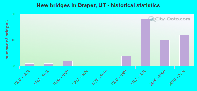
- New bridges - historical statistics
- 11930-1939
- 11940-1949
- 21950-1959
- 41980-1989
- 181990-1999
- 102000-2009
- 122010-2019
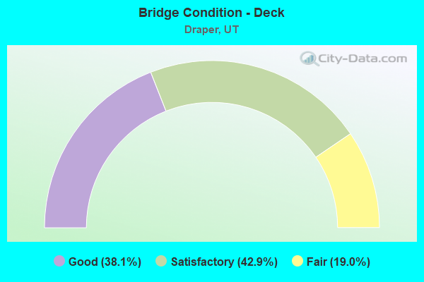
- Bridge Condition - Deck
- 38.1%Good
- 42.9%Satisfactory
- 19.0%Fair
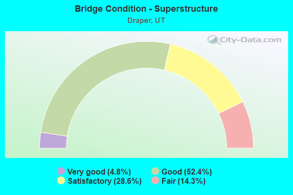
- Bridge Condition - Superstructure
- 4.8%Very good
- 52.4%Good
- 28.6%Satisfactory
- 14.3%Fair
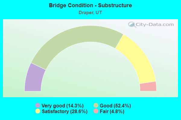
- Bridge Condition - Substructure
- 14.3%Very good
- 52.4%Good
- 28.6%Satisfactory
- 4.8%Fair

- Bridge Condition - Channel
- 17.1%Very good
- 68.6%Good
- 14.3%Satisfactory
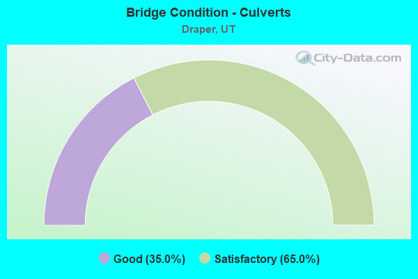
- Bridge Condition - Culverts
- 35.0%Good
- 65.0%Satisfactory
Find on map >> Show street view
Structure Number: 35250E, Location: 13065 S. 220 West (Lat: 40.513456, Lng: -111.896697), Route carried "on" structure: City street 2213, Year Built: 2019, Status: Open, Structure Length: 0.98m (3.22ft), Average Daily Traffic: 3,262 (year 2020), Average Future Daily Traffic: 4,078 (year 2040), Features Intersected: Jordan and Salt Lake can, Facility Carried by Structure: Ikea way in Draper
Minimum Vertical Clearance: 30+ m (98+ ft), Kilometerpoint: 0.000, Lanes on structure: 5, Owner: City or Municipal Highway Agency, Approaching Roadway Width: 19.8m (65.0ft), Skew: 4 degrees, Material/Design: Concrete, Design/Construction: Culvert, Number Of Spans In Main Unit: 1, Length of Maximum Span: 7.3m (24.0ft), Curb or Sidewalk Widths: Left: 2.4m (7.9ft), Right: 3.0m (9.8ft), Curb-To-Curb Width: 19.8m (65.0ft), Out-to-Out Width: 43.0m (141.1ft)
Condition: Channel: Good, Culverts: Good, Deck Geometry: Meets minimum limits, Waterway Adequacy: Equal to present desirable criteria, Approach Roadway Alignment: Equal to present desirable criteria, Designated Inspection Frequency: Every 24 months, Inspection Date: December 2021
Find on map >> Show street view
Structure Number: C 818, Location: 800 W.14000 SO.-BLUFFDALE (Lat: 40.497006, Lng: -111.914042), Route carried "under" structure: State highway 154, Year Built: 1998, Structure Length: 0. m, Average Daily Traffic: 56,887 (year 2020), Truck Traffic: 26%, Features Intersected: SR-154, (BANGERTER HWY.), Facility Carried by Structure: UNION PACIFIC RR.
Minimum Vertical Clearance: 5.23m (17.16ft), Kilometerpoint: 3.010, Material/Design: Steel, Design/Construction: Stringer/Multi-beam, Length of Maximum Span: 25.8m (84.6ft)
Find on map >> Show street view
Structure Number: C 819, Location: 13600 SO.& I-15 IN DRAPER (Lat: 40.504367, Lng: -111.890653), Route carried "under" structure: Interstate 15, Year Built: 1998, Structure Length: 0. m, Average Daily Traffic: 148,472 (year 2020), Truck Traffic: 16%, Features Intersected: I-15 (SR-15), NBL & SBL
Minimum Vertical Clearance: 5.23m (17.16ft), Kilometerpoint: 466.439, Lanes on structure: 6, Lanes under structure: 8, Material/Design: Steel continuous, Design/Construction: Stringer/Multi-beam, Length of Maximum Span: 27.1m (88.9ft)
Find on map >> Show street view
Structure Number: F 696, Location: 500 West 12300 South (Lat: 40.526822, Lng: -111.904736), Route carried "under" structure: State highway 71, Year Built: 2004, Structure Length: 0. m, Average Daily Traffic: 29,107 (year 2020), Truck Traffic: 29%, Features Intersected: SR-71, 12300 SOUTH ST., Facility Carried by Structure: UPRR and UTA
Minimum Vertical Clearance: 5.49m (18.01ft), Kilometerpoint: 6.866, Lanes under structure: 4, Material/Design: Prestressed concrete, Design/Construction: Stringer/Multi-beam, Length of Maximum Span: 16.6m (54.5ft)
Find on map >> Show street view
Structure Number: F 777, Location: 1.4 Mi.W. of I-15 Intchg. (Lat: 40.496969, Lng: -111.914244), Route carried "under" structure: State highway 154, Year Built: 2011, Structure Length: 0. m, Average Daily Traffic: 56,887 (year 2020), Truck Traffic: 26%, Features Intersected: SR-154,BANGERTER HIGHWAY, Facility Carried by Structure: UTA, FRONT RUNNER
Minimum Vertical Clearance: 5.61m (18.41ft), Kilometerpoint: 3.027, Material/Design: Prestressed concrete, Design/Construction: Box Beam or Girders - Multiple, Length of Maximum Span: 30.7m (100.7ft)
Find on map >> Show street view
Structure Number: 1F 694, Location: At the DRAPER X-ROADS.INT (Lat: 40.526414, Lng: -111.890981), Route carried "under" structure: State highway 71, Year Built: 2004, Structure Length: 0. m, Average Daily Traffic: 29,591 (year 2020), Truck Traffic: 27%, Features Intersected: SR-71, INTCHG. X-ROAD., Facility Carried by Structure: I-15 (SR-15) NB.
Minimum Vertical Clearance: 5.00m (16.40ft), Kilometerpoint: 8.016, Lanes on structure: 5, Lanes under structure: 6, Material/Design: Prestressed concrete continuous, Design/Construction: Stringer/Multi-beam, Length of Maximum Span: 59.6m (195.5ft)
Find on map >> Show street view
Structure Number: 1F 784, Location: At the 114th South Intchg (Lat: 40.543953, Lng: -111.894525), Route carried "under" structure: Alternate State highway 175, Year Built: 2010, Structure Length: 0. m, Average Daily Traffic: 19,836 (year 2020), Truck Traffic: 29%, Features Intersected: SR-175, 11400 SO. ST., Facility Carried by Structure: I-15 NB (SR-15)
Minimum Vertical Clearance: 5.08m (16.67ft), Kilometerpoint: 6.085, Lanes on structure: 5, Lanes under structure: 8, Material/Design: Prestressed concrete, Design/Construction: Stringer/Multi-beam, Length of Maximum Span: 64.6m (211.9ft)
Find on map >> Show street view
Structure Number: 3F 694, Location: At the DRAPER X-ROADS.INT (Lat: 40.527150, Lng: -111.891289), Route carried "under" structure: State highway 71, Year Built: 2004, Structure Length: 0. m, Average Daily Traffic: 29,591 (year 2020), Truck Traffic: 27%, Features Intersected: SR-71, INTCHG. X-ROAD., Facility Carried by Structure: I-15 (SR-15) SB
Minimum Vertical Clearance: 5.00m (16.40ft), Kilometerpoint: 7.992, Lanes on structure: 5, Lanes under structure: 6, Material/Design: Prestressed concrete continuous, Design/Construction: Stringer/Multi-beam, Length of Maximum Span: 59.6m (195.5ft)