Bridge Statistics for Dundalk, Maryland (MD)
Condition, Traffic, Stress, Structural Evaluation, Project Costs
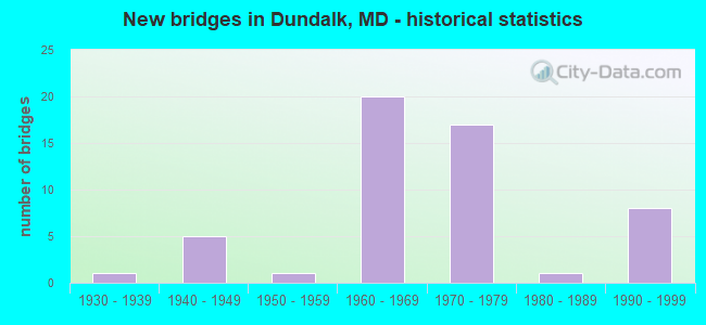
- New bridges - historical statistics
- 11930-1939
- 51940-1949
- 11950-1959
- 201960-1969
- 171970-1979
- 11980-1989
- 81990-1999
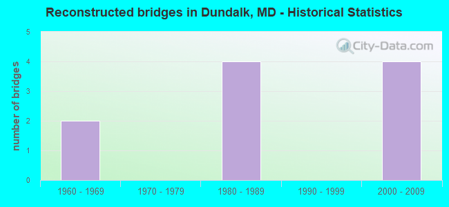
- Reconstructed bridges - Historical Statistics
- 21960-1969
- 01970-1979
- 41980-1989
- 01990-1999
- 42000-2009

- Bridge Condition - Deck
- 29.0%Good
- 61.3%Satisfactory
- 9.7%Fair
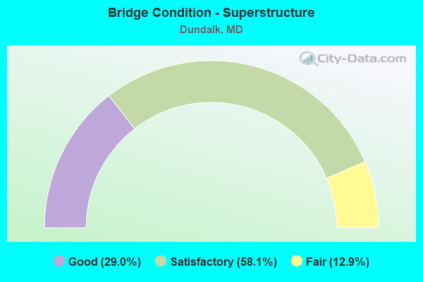
- Bridge Condition - Superstructure
- 29.0%Good
- 58.1%Satisfactory
- 12.9%Fair
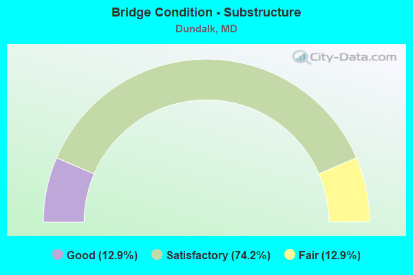
- Bridge Condition - Substructure
- 12.9%Good
- 74.2%Satisfactory
- 12.9%Fair
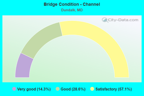
- Bridge Condition - Channel
- 14.3%Very good
- 28.6%Good
- 57.1%Satisfactory
Find on map >> Show street view
Structure Number: 10000003009701, Location: 0.82 MILE EAST OF MD 695 (Lat: 39.300886, Lng: -76.491433), Route carried "on" structure: State highway 150, Year Built: 1988, Status: Open, Structure Length: 45.96m (150.79ft), Average Daily Traffic: 29,630 (year 2009), Truck Traffic: 8%, Average Future Daily Traffic: 36,504 (year 2026), Design Load: HS 20, Features Intersected: BACK RIVER
Minimum Vertical Clearance: 30+ m (98+ ft), Kilometerpoint: 3.878, Lanes on structure: 4, Base Highway Network: Yes, Owner: State Highway Agency, Approaching Roadway Width: 20.4m (66.9ft), Skew: 20 degrees, Material/Design: Prestressed concrete, Design/Construction: Stringer/Multi-beam, Number Of Spans In Main Unit: 15, Length of Maximum Span: 30.5m (100.1ft), Curb or Sidewalk Widths: Left: 1.6m (5.2ft), Right: 1.6m (5.2ft), Curb-To-Curb Width: 16.8m (55.1ft), Out-to-Out Width: 20.5m (67.3ft)
Condition: Deck: Good, Superstructure: Good, Substructure: Good, Channel: Good, Operating Rating: 87.1 metric tons, Method Used To Determine Operating Rating: Load Factor (LF), Inventory Rating: 50.8 metric tons, Method Used To Determine Inventory Rating: Load Factor (LF), Structural Evaluation: Better than present minimum criteria, Deck Geometry: Somewhat better than minimum adequacy, Waterway Adequacy: Equal to present desirable criteria, Approach Roadway Alignment: Equal to present desirable criteria, Length Of Structure Improvement: 45.96m (150.79ft), Designated Inspection Frequency: Every 24 months, Underwater Inspection Frequency: Every 48 months, Inspection Date: August 2021, Underwater Inspection Date: December 2019, Bridge Improvement Cost: $6,080,000, Roadway Improvement Cost: $608,000, Total Project Cost: $6,688,000, Deck Structure Type: Concrete Cast-file-Place, Wearing Surface/Protective System: Wearing Surface: Monolithic Concrete, Deck Protection: Epoxy Coated Reinforcing
Find on map >> Show street view
Structure Number: 100000030098013, Location: 0.21 M S OF CONLEY STREET (Lat: 39.293397, Lng: -76.516778), Route carried "on" structure: State highway 151, Year Built: 1942, Year Reconstructed: 1980, Status: Open, Structure Length: 5.12m (16.80ft), Average Daily Traffic: 23,941 (year 2009), Truck Traffic: 8%, Average Future Daily Traffic: 12,944 (year 2026), Design Load: H 20, Features Intersected: MD 150
Minimum Vertical Clearance: 30+ m (98+ ft), Kilometerpoint: 11.004, Lanes on structure: 3, Lanes under structure: 6, Base Highway Network: Yes, Owner: State Highway Agency, Approaching Roadway Width: 12.5m (41.0ft), Skew: 5 degrees, Material/Design: Steel, Design/Construction: Stringer/Multi-beam, Number Of Spans In Main Unit: 2, Length of Maximum Span: 24.7m (81.0ft), Curb or Sidewalk Widths: Left: 0.0m, Right: 1.3m (4.3ft), Curb-To-Curb Width: 12.5m (41.0ft), Out-to-Out Width: 14.6m (47.9ft)
Condition: Deck: Satisfactory, Superstructure: Satisfactory, Substructure: Satisfactory, Operating Rating: 88.4 metric tons, Method Used To Determine Operating Rating: Load Factor (LF), Inventory Rating: 53.1 metric tons, Method Used To Determine Inventory Rating: Load Factor (LF), Structural Evaluation: Equal to present minimum criteria, Deck Geometry: Meets minimum limits, Underclear: Equal to present minimum criteria, Approach Roadway Alignment: Equal to present desirable criteria, Length Of Structure Improvement: 5.12m (16.80ft), Designated Inspection Frequency: Every 24 months, Inspection Date: January 2021, Bridge Improvement Cost: $482,000, Roadway Improvement Cost: $48,000, Total Project Cost: $530,000, Deck Structure Type: Concrete Cast-file-Place, Wearing Surface/Protective System: Wearing Surface: Monolithic Concrete
Find on map >> Show street view
Structure Number: 100000030098014, Location: 0.21 M S OF CONLEY STREET (Lat: 39.293458, Lng: -76.517639), Route carried "on" structure: State highway 151, Year Built: 1942, Year Reconstructed: 1980, Status: Open, Structure Length: 5.12m (16.80ft), Average Daily Traffic: 23,941 (year 2009), Truck Traffic: 8%, Average Future Daily Traffic: 12,944 (year 2026), Design Load: H 20, Features Intersected: MD 150
Minimum Vertical Clearance: 30+ m (98+ ft), Kilometerpoint: 11.004, Lanes on structure: 3, Lanes under structure: 6, Base Highway Network: Yes, Owner: State Highway Agency, Approaching Roadway Width: 12.5m (41.0ft), Skew: 5 degrees, Material/Design: Steel, Design/Construction: Stringer/Multi-beam, Number Of Spans In Main Unit: 2, Length of Maximum Span: 24.7m (81.0ft), Curb or Sidewalk Widths: Left: 0.0m, Right: 1.3m (4.3ft), Curb-To-Curb Width: 12.5m (41.0ft), Out-to-Out Width: 14.6m (47.9ft)
Condition: Deck: Satisfactory, Superstructure: Satisfactory, Substructure: Satisfactory, Operating Rating: 88.4 metric tons, Method Used To Determine Operating Rating: Load Factor (LF), Inventory Rating: 53.1 metric tons, Method Used To Determine Inventory Rating: Load Factor (LF), Structural Evaluation: Equal to present minimum criteria, Deck Geometry: Meets minimum limits, Underclear: Equal to present minimum criteria, Approach Roadway Alignment: Equal to present desirable criteria, Length Of Structure Improvement: 5.12m (16.80ft), Designated Inspection Frequency: Every 24 months, Inspection Date: January 2021, Bridge Improvement Cost: $482,000, Roadway Improvement Cost: $48,000, Total Project Cost: $530,000, Deck Structure Type: Concrete Cast-file-Place, Wearing Surface/Protective System: Wearing Surface: Monolithic Concrete
Find on map >> Show street view
Structure Number: 100000030223015, Location: 0.62 MILE NORTH OF MD 150 (Lat: 39.289272, Lng: -76.501119), Route carried "on" structure: State highway 695, Year Built: 1967, Year Reconstructed: 1973, Status: Open, Structure Length: 7.53m (24.70ft), Average Daily Traffic: 41,012 (year 2009), Truck Traffic: 8%, Average Future Daily Traffic: 22,055 (year 2026), Design Load: HS 20+Mod, Features Intersected: MD 151 NBR
Minimum Vertical Clearance: 30+ m (98+ ft), Kilometerpoint: 7.656, Lanes on structure: 3, Lanes under structure: 3, Base Highway Network: Yes, Owner: State Highway Agency, Approaching Roadway Width: 15.2m (49.9ft), Skew: 5 degrees, Material/Design: Steel, Design/Construction: Stringer/Multi-beam, Number Of Spans In Main Unit: 1, Number Of Approach Spans: 2, Length of Maximum Span: 33.5m (109.9ft), Curb-To-Curb Width: 16.9m (55.4ft), Out-to-Out Width: 18.0m (59.1ft)
Condition: Deck: Satisfactory, Superstructure: Satisfactory, Substructure: Satisfactory, Operating Rating: 47.6 metric tons, Method Used To Determine Operating Rating: Load Factor (LF), Inventory Rating: 28.6 metric tons, Method Used To Determine Inventory Rating: Load Factor (LF), Structural Evaluation: Equal to present minimum criteria, Deck Geometry: Equal to present minimum criteria, Underclear: Equal to present minimum criteria, Approach Roadway Alignment: Equal to present desirable criteria, Designated Inspection Frequency: Every 24 months, Inspection Date: April 2020, Deck Structure Type: Concrete Cast-file-Place, Wearing Surface/Protective System: Wearing Surface: Latex Concrete
Find on map >> Show street view
Structure Number: 100000030223016, Location: 0.62 MILE NORTH OF MD 150 (Lat: 39.288628, Lng: -76.499900), Route carried "on" structure: State highway 695, Year Built: 1967, Status: Open, Structure Length: 7.47m (24.51ft), Average Daily Traffic: 41,012 (year 2009), Truck Traffic: 8%, Average Future Daily Traffic: 22,055 (year 2026), Design Load: HS 20, Features Intersected: MD 151 NBR
Minimum Vertical Clearance: 30+ m (98+ ft), Kilometerpoint: 7.656, Lanes on structure: 3, Lanes under structure: 3, Base Highway Network: Yes, Owner: State Highway Agency, Approaching Roadway Width: 15.2m (49.9ft), Skew: 5 degrees, Material/Design: Steel, Design/Construction: Stringer/Multi-beam, Number Of Spans In Main Unit: 1, Number Of Approach Spans: 2, Length of Maximum Span: 34.4m (112.9ft), Curb-To-Curb Width: 16.9m (55.4ft), Out-to-Out Width: 18.0m (59.1ft)
Condition: Deck: Satisfactory, Superstructure: Satisfactory, Substructure: Fair, Operating Rating: 48.1 metric tons, Method Used To Determine Operating Rating: Load Factor (LF), Inventory Rating: 28.6 metric tons, Method Used To Determine Inventory Rating: Load Factor (LF), Structural Evaluation: Somewhat better than minimum adequacy, Deck Geometry: Equal to present minimum criteria, Underclear: Equal to present minimum criteria, Approach Roadway Alignment: Equal to present desirable criteria, Length Of Structure Improvement: 7.47m (24.51ft), Designated Inspection Frequency: Every 24 months, Inspection Date: April 2020, Bridge Improvement Cost: $870,000, Roadway Improvement Cost: $87,000, Total Project Cost: $957,000, Deck Structure Type: Concrete Cast-file-Place, Wearing Surface/Protective System: Wearing Surface: Latex Concrete
Find on map >> Show street view
Structure Number: 100000030224015, Location: 0.18 MILE SOUTH OF MD 151 (Lat: 39.291408, Lng: -76.502869), Route carried "on" structure: State highway 695, Year Built: 1966, Year Reconstructed: 2006, Status: Open, Structure Length: 6.34m (20.80ft), Average Daily Traffic: 41,012 (year 2009), Truck Traffic: 8%, Average Future Daily Traffic: 22,055 (year 2026), Design Load: HS 20+Mod, Features Intersected: NORFOLK SOUTHERN RR
Minimum Vertical Clearance: 30+ m (98+ ft), Kilometerpoint: 7.382, Lanes on structure: 2, Base Highway Network: Yes, Owner: State Highway Agency, Approaching Roadway Width: 11.6m (38.1ft), Skew: 5 degrees, Material/Design: Steel, Design/Construction: Stringer/Multi-beam, Number Of Spans In Main Unit: 3, Length of Maximum Span: 23.8m (78.1ft), Curb-To-Curb Width: 13.3m (43.6ft), Out-to-Out Width: 14.4m (47.2ft)
Condition: Deck: Satisfactory, Superstructure: Satisfactory, Substructure: Satisfactory, Operating Rating: 74.8 metric tons, Method Used To Determine Operating Rating: Load Factor (LF), Inventory Rating: 44.9 metric tons, Method Used To Determine Inventory Rating: Load Factor (LF), Structural Evaluation: Equal to present minimum criteria, Deck Geometry: Superior to present desirable criteria, Underclear: Somewhat better than minimum adequacy, Approach Roadway Alignment: Equal to present desirable criteria, Length Of Structure Improvement: 6.34m (20.80ft), Designated Inspection Frequency: Every 24 months, Inspection Date: May 2021, Bridge Improvement Cost: $589,000, Roadway Improvement Cost: $59,000, Total Project Cost: $648,000, Deck Structure Type: Concrete Cast-file-Place, Wearing Surface/Protective System: Wearing Surface: Latex Concrete
Find on map >> Show street view
Structure Number: 100000030224016, Location: 0.18 MILE SOUTH OF MD 151 (Lat: 39.290728, Lng: -76.502033), Route carried "on" structure: State highway 695, Year Built: 1966, Status: Open, Structure Length: 6.55m (21.49ft), Average Daily Traffic: 41,012 (year 2009), Truck Traffic: 8%, Average Future Daily Traffic: 22,055 (year 2026), Design Load: HS 20+Mod, Features Intersected: NORFOLK SOUTHERN RR
Minimum Vertical Clearance: 30+ m (98+ ft), Kilometerpoint: 7.382, Lanes on structure: 4, Base Highway Network: Yes, Owner: State Highway Agency, Approaching Roadway Width: 11.6m (38.1ft), Skew: 5 degrees, Material/Design: Steel, Design/Construction: Stringer/Multi-beam, Number Of Spans In Main Unit: 3, Length of Maximum Span: 24.7m (81.0ft), Curb-To-Curb Width: 21.3m (69.9ft), Out-to-Out Width: 22.4m (73.5ft)
Condition: Deck: Good, Superstructure: Satisfactory, Substructure: Satisfactory, Operating Rating: 49.0 metric tons, Method Used To Determine Operating Rating: Load Factor (LF), Inventory Rating: 29.5 metric tons, Method Used To Determine Inventory Rating: Load Factor (LF), Structural Evaluation: Equal to present minimum criteria, Deck Geometry: Better than present minimum criteria, Underclear: Somewhat better than minimum adequacy, Approach Roadway Alignment: Equal to present desirable criteria, Designated Inspection Frequency: Every 24 months, Inspection Date: May 2021, Deck Structure Type: Concrete Cast-file-Place, Wearing Surface/Protective System: Wearing Surface: Bituminous
Find on map >> Show street view
Structure Number: 100000030225015, Location: 0.26 MILE SOUTH OF MD 151 (Lat: 39.292672, Lng: -76.503492), Route carried "on" structure: State highway 695, Year Built: 1966, Status: Open, Structure Length: 8.84m (29.00ft), Average Daily Traffic: 41,012 (year 2009), Truck Traffic: 8%, Average Future Daily Traffic: 22,055 (year 2026), Design Load: HS 20+Mod, Features Intersected: MD 695 RMP 1(MERRITT BL)
Minimum Vertical Clearance: 30+ m (98+ ft), Kilometerpoint: 7.241, Lanes on structure: 2, Lanes under structure: 2, Base Highway Network: Yes, Owner: State Highway Agency, Approaching Roadway Width: 11.6m (38.1ft), Skew: 5 degrees, Material/Design: Steel continuous, Design/Construction: Stringer/Multi-beam, Number Of Spans In Main Unit: 1, Number Of Approach Spans: 2, Length of Maximum Span: 34.7m (113.8ft), Curb-To-Curb Width: 13.3m (43.6ft), Out-to-Out Width: 14.4m (47.2ft)
Condition: Deck: Satisfactory, Superstructure: Satisfactory, Substructure: Satisfactory, Operating Rating: 57.1 metric tons, Method Used To Determine Operating Rating: Load Factor (LF), Inventory Rating: 34.0 metric tons, Method Used To Determine Inventory Rating: Load Factor (LF), Structural Evaluation: Equal to present minimum criteria, Deck Geometry: Superior to present desirable criteria, Underclear: Meets minimum limits, Approach Roadway Alignment: Equal to present desirable criteria, Length Of Structure Improvement: 8.84m (29.00ft), Designated Inspection Frequency: Every 24 months, Inspection Date: May 2021, Bridge Improvement Cost: $821,000, Roadway Improvement Cost: $82,000, Total Project Cost: $903,000, Deck Structure Type: Concrete Cast-file-Place, Wearing Surface/Protective System: Wearing Surface: Latex Concrete
Find on map >> Show street view
Structure Number: 100000030225016, Location: 0.26 MILE SOUTH OF MD 151 (Lat: 39.292425, Lng: -76.503064), Route carried "on" structure: State highway 695, Year Built: 1966, Status: Open, Structure Length: 7.62m (25.00ft), Average Daily Traffic: 41,012 (year 2009), Truck Traffic: 8%, Average Future Daily Traffic: 22,055 (year 2026), Design Load: HS 20+Mod, Features Intersected: MD 695 RMP 1(MERRITT BL)
Minimum Vertical Clearance: 30+ m (98+ ft), Kilometerpoint: 7.241, Lanes on structure: 2, Lanes under structure: 2, Base Highway Network: Yes, Owner: State Highway Agency, Approaching Roadway Width: 11.6m (38.1ft), Skew: 5 degrees, Material/Design: Steel, Design/Construction: Stringer/Multi-beam, Number Of Spans In Main Unit: 1, Number Of Approach Spans: 2, Length of Maximum Span: 28.7m (94.2ft), Curb-To-Curb Width: 13.3m (43.6ft), Out-to-Out Width: 14.4m (47.2ft)
Condition: Deck: Satisfactory, Superstructure: Satisfactory, Substructure: Satisfactory, Operating Rating: 66.7 metric tons, Method Used To Determine Operating Rating: Load Factor (LF), Inventory Rating: 39.9 metric tons, Method Used To Determine Inventory Rating: Load Factor (LF), Structural Evaluation: Equal to present minimum criteria, Deck Geometry: Superior to present desirable criteria, Underclear: Meets minimum limits, Approach Roadway Alignment: Equal to present minimum criteria, Length Of Structure Improvement: 7.62m (25.00ft), Designated Inspection Frequency: Every 24 months, Inspection Date: May 2021, Bridge Improvement Cost: $708,000, Roadway Improvement Cost: $71,000, Total Project Cost: $779,000, Deck Structure Type: Concrete Cast-file-Place, Wearing Surface/Protective System: Wearing Surface: Latex Concrete
Find on map >> Show street view
Structure Number: 100000030226015, Location: 0.62 MILE SOUTH OF MD 151 (Lat: 39.297047, Lng: -76.503058), Route carried "on" structure: State highway 695, Year Built: 1965, Status: Open, Structure Length: 7.44m (24.41ft), Average Daily Traffic: 41,012 (year 2009), Truck Traffic: 8%, Average Future Daily Traffic: 22,055 (year 2026), Design Load: HS 20, Features Intersected: MD 150
Minimum Vertical Clearance: 30+ m (98+ ft), Kilometerpoint: 6.618, Lanes on structure: 3, Lanes under structure: 6, Base Highway Network: Yes, Owner: State Highway Agency, Approaching Roadway Width: 11.6m (38.1ft), Skew: 3 degrees, Material/Design: Steel, Design/Construction: Stringer/Multi-beam, Number Of Spans In Main Unit: 4, Length of Maximum Span: 22.9m (75.1ft), Curb-To-Curb Width: 16.9m (55.4ft), Out-to-Out Width: 18.0m (59.1ft)
Condition: Deck: Satisfactory, Superstructure: Satisfactory, Substructure: Satisfactory, Operating Rating: 51.7 metric tons, Method Used To Determine Operating Rating: Load Factor (LF), Inventory Rating: 30.8 metric tons, Method Used To Determine Inventory Rating: Load Factor (LF), Structural Evaluation: Equal to present minimum criteria, Deck Geometry: Equal to present minimum criteria, Underclear: Better than present minimum criteria, Approach Roadway Alignment: Equal to present desirable criteria, Length Of Structure Improvement: 7.44m (24.41ft), Designated Inspection Frequency: Every 24 months, Inspection Date: September 2020, Bridge Improvement Cost: $867,000, Roadway Improvement Cost: $87,000, Total Project Cost: $954,000, Deck Structure Type: Concrete Cast-file-Place, Wearing Surface/Protective System: Wearing Surface: Bituminous
Find on map >> Show street view
Structure Number: 100000030226016, Location: 0.62 MILE SOUTH OF MD 151 (Lat: 39.297192, Lng: -76.502550), Route carried "on" structure: State highway 695, Year Built: 1965, Status: Open, Structure Length: 7.32m (24.02ft), Average Daily Traffic: 41,012 (year 2009), Truck Traffic: 8%, Average Future Daily Traffic: 22,055 (year 2026), Design Load: HS 20, Features Intersected: MD 150
Minimum Vertical Clearance: 30+ m (98+ ft), Kilometerpoint: 6.618, Lanes on structure: 4, Lanes under structure: 6, Base Highway Network: Yes, Owner: State Highway Agency, Approaching Roadway Width: 23.2m (76.1ft), Skew: 23 degrees, Material/Design: Steel, Design/Construction: Stringer/Multi-beam, Number Of Spans In Main Unit: 4, Length of Maximum Span: 22.9m (75.1ft), Curb-To-Curb Width: 24.9m (81.7ft), Out-to-Out Width: 26.0m (85.3ft)
Condition: Deck: Satisfactory, Superstructure: Satisfactory, Substructure: Satisfactory, Operating Rating: 49.4 metric tons, Method Used To Determine Operating Rating: Load Factor (LF), Inventory Rating: 29.5 metric tons, Method Used To Determine Inventory Rating: Load Factor (LF), Structural Evaluation: Equal to present minimum criteria, Deck Geometry: Superior to present desirable criteria, Underclear: Better than present minimum criteria, Approach Roadway Alignment: Equal to present desirable criteria, Length Of Structure Improvement: 7.32m (24.02ft), Designated Inspection Frequency: Every 24 months, Inspection Date: September 2020, Bridge Improvement Cost: $2,454,000, Roadway Improvement Cost: $245,000, Total Project Cost: $2,699,000, Deck Structure Type: Concrete Cast-file-Place, Wearing Surface/Protective System: Wearing Surface: Bituminous
Find on map >> Show street view
Structure Number: 100000030238016, Location: 0.75 MILE SOUTH OF MD 150 (Lat: 39.302392, Lng: -76.500808), Route carried "on" structure: State highway 695, Year Built: 1968, Year Reconstructed: 2006, Status: Open, Structure Length: 65.65m (215.39ft), Average Daily Traffic: 69,922 (year 2009), Truck Traffic: 8%, Average Future Daily Traffic: 44,150 (year 2028), Design Load: HS 20, Features Intersected: AMTRAK & BACK RIVER
Minimum Vertical Clearance: 30+ m (98+ ft), Kilometerpoint: 5.438, Lanes on structure: 3, Base Highway Network: Yes, Owner: State Highway Agency, Approaching Roadway Width: 17.1m (56.1ft), Skew: 9 degrees, Material/Design: Steel, Design/Construction: Stringer/Multi-beam, Number Of Spans In Main Unit: 3, Number Of Approach Spans: 39, Length of Maximum Span: 26.2m (86.0ft), Curb-To-Curb Width: 15.4m (50.5ft), Out-to-Out Width: 16.5m (54.1ft)
Condition: Deck: Satisfactory, Superstructure: Satisfactory, Substructure: Satisfactory, Channel: Satisfactory, Operating Rating: 59.9 metric tons, Method Used To Determine Operating Rating: Load Factor (LF), Inventory Rating: 35.8 metric tons, Method Used To Determine Inventory Rating: Load Factor (LF), Structural Evaluation: Equal to present minimum criteria, Deck Geometry: Somewhat better than minimum adequacy, Underclear: Superior to present desirable criteria, Waterway Adequacy: Equal to present desirable criteria, Approach Roadway Alignment: Equal to present desirable criteria, Designated Inspection Frequency: Every 24 months, Underwater Inspection Frequency: Every 48 months, Inspection Date: March 2021, Underwater Inspection Date: August 2019, Deck Structure Type: Concrete Cast-file-Place, Wearing Surface/Protective System: Wearing Surface: Latex Concrete
Find on map >> Show street view
Structure Number: 100000030242013, Location: 0.21 MI N OF MD 695 (Lat: 39.289828, Lng: -76.503992), Route carried "on" structure: State highway 151, Year Built: 1968, Status: Open, Structure Length: 5.46m (17.91ft), Average Daily Traffic: 30,031 (year 2009), Truck Traffic: 8%, Average Future Daily Traffic: 16,426 (year 2026), Design Load: HS 20, Features Intersected: MERRITT BOULEVARD
Minimum Vertical Clearance: 30+ m (98+ ft), Kilometerpoint: 9.831, Lanes on structure: 3, Lanes under structure: 4, Base Highway Network: Yes, Owner: State Highway Agency, Approaching Roadway Width: 15.2m (49.9ft), Material/Design: Steel, Design/Construction: Stringer/Multi-beam, Number Of Spans In Main Unit: 4, Length of Maximum Span: 16.2m (53.1ft), Curb-To-Curb Width: 15.9m (52.2ft), Out-to-Out Width: 16.5m (54.1ft)
Condition: Deck: Satisfactory, Superstructure: Good, Substructure: Satisfactory, Operating Rating: 81.2 metric tons, Method Used To Determine Operating Rating: Load Factor (LF), Inventory Rating: 48.5 metric tons, Method Used To Determine Inventory Rating: Load Factor (LF), Structural Evaluation: Equal to present minimum criteria, Deck Geometry: Better than present minimum criteria, Underclear: Somewhat better than minimum adequacy, Approach Roadway Alignment: Equal to present desirable criteria, Designated Inspection Frequency: Every 24 months, Inspection Date: September 2021, Deck Structure Type: Concrete Cast-file-Place, Wearing Surface/Protective System: Wearing Surface: Bituminous
Find on map >> Show street view
Structure Number: 100000030242014, Location: 0.21 MI N OF MD 695 (Lat: 39.289792, Lng: -76.504678), Route carried "on" structure: State highway 151, Year Built: 1968, Status: Open, Structure Length: 5.64m (18.50ft), Average Daily Traffic: 30,031 (year 2009), Truck Traffic: 8%, Average Future Daily Traffic: 16,426 (year 2026), Design Load: HS 20, Features Intersected: MERRITT BOULEVARD
Minimum Vertical Clearance: 30+ m (98+ ft), Kilometerpoint: 9.831, Lanes on structure: 3, Lanes under structure: 4, Base Highway Network: Yes, Owner: State Highway Agency, Approaching Roadway Width: 15.2m (49.9ft), Material/Design: Steel, Design/Construction: Stringer/Multi-beam, Number Of Spans In Main Unit: 4, Length of Maximum Span: 18.0m (59.1ft), Curb-To-Curb Width: 17.4m (57.1ft), Out-to-Out Width: 18.0m (59.1ft)
Condition: Deck: Satisfactory, Superstructure: Good, Substructure: Satisfactory, Operating Rating: 46.3 metric tons, Method Used To Determine Operating Rating: Load Factor (LF), Inventory Rating: 27.7 metric tons, Method Used To Determine Inventory Rating: Load Factor (LF), Structural Evaluation: Equal to present minimum criteria, Deck Geometry: Superior to present desirable criteria, Underclear: Somewhat better than minimum adequacy, Approach Roadway Alignment: Equal to present desirable criteria, Designated Inspection Frequency: Every 24 months, Inspection Date: September 2021, Deck Structure Type: Concrete Cast-file-Place, Wearing Surface/Protective System: Wearing Surface: Bituminous
Find on map >> Show street view
Structure Number: 10000003024401, Location: 1.78 MI N OF MD 20D (Lat: 39.270336, Lng: -76.465011), Route carried "on" structure: County highway 5524, Year Built: 1970, Status: Open, Structure Length: 7.44m (24.41ft), Average Daily Traffic: 999 (year 2007), Truck Traffic: 5%, Average Future Daily Traffic: 1,319 (year 2022), Design Load: HS 20, Features Intersected: MD 695, Facility Carried by Structure: BEACHWOOD ROAD
Minimum Vertical Clearance: 30+ m (98+ ft), Kilometerpoint: 0.177, Lanes on structure: 2, Lanes under structure: 4, Owner: State Highway Agency, Approaching Roadway Width: 12.2m (40.0ft), Material/Design: Steel continuous, Design/Construction: Stringer/Multi-beam, Number Of Spans In Main Unit: 2, Number Of Approach Spans: 2, Length of Maximum Span: 23.5m (77.1ft), Curb-To-Curb Width: 12.2m (40.0ft), Out-to-Out Width: 13.1m (43.0ft)
Condition: Deck: Fair, Superstructure: Satisfactory, Substructure: Satisfactory, Operating Rating: 67.1 metric tons, Method Used To Determine Operating Rating: Load Factor (LF), Inventory Rating: 40.4 metric tons, Method Used To Determine Inventory Rating: Load Factor (LF), Structural Evaluation: Equal to present minimum criteria, Deck Geometry: Equal to present desirable criteria, Underclear: Somewhat better than minimum adequacy, Approach Roadway Alignment: Equal to present desirable criteria, Designated Inspection Frequency: Every 24 months, Inspection Date: October 2020, Deck Structure Type: Concrete Cast-file-Place, Wearing Surface/Protective System: Wearing Surface: Monolithic Concrete
Find on map >> Show street view
Structure Number: 10000003024701, Location: 0.38 MI S OF MD 151 (Lat: 39.281606, Lng: -76.483758), Route carried "on" structure: County highway 5510, Year Built: 1970, Status: Open, Structure Length: 7.80m (25.59ft), Average Daily Traffic: 999 (year 1994), Truck Traffic: 5%, Average Future Daily Traffic: 1,178 (year 2012), Design Load: HS 20, Features Intersected: MD 695, Facility Carried by Structure: TRAPPE ROAD
Minimum Vertical Clearance: 30+ m (98+ ft), Kilometerpoint: 0.225, Lanes on structure: 2, Lanes under structure: 4, Owner: State Highway Agency, Approaching Roadway Width: 12.2m (40.0ft), Skew: 2 degrees, Material/Design: Steel continuous, Design/Construction: Stringer/Multi-beam, Number Of Spans In Main Unit: 2, Number Of Approach Spans: 2, Length of Maximum Span: 25.3m (83.0ft), Curb-To-Curb Width: 12.2m (40.0ft), Out-to-Out Width: 13.1m (43.0ft)
Condition: Deck: Satisfactory, Superstructure: Satisfactory, Substructure: Satisfactory, Operating Rating: 87.1 metric tons, Method Used To Determine Operating Rating: Load Factor (LF), Inventory Rating: 52.2 metric tons, Method Used To Determine Inventory Rating: Load Factor (LF), Structural Evaluation: Equal to present minimum criteria, Deck Geometry: Equal to present desirable criteria, Underclear: Somewhat better than minimum adequacy, Approach Roadway Alignment: Equal to present desirable criteria, Designated Inspection Frequency: Every 24 months, Inspection Date: October 2020, Deck Structure Type: Concrete Cast-file-Place, Wearing Surface/Protective System: Wearing Surface: Monolithic Concrete
Find on map >> Show street view
Structure Number: 10000003024801, Location: 1.03 MI S OF MD 151 (Lat: 39.277558, Lng: -76.472894), Route carried "on" structure: County highway 5820, Year Built: 1971, Status: Open, Structure Length: 7.44m (24.41ft), Average Daily Traffic: 5,699 (year 2006), Truck Traffic: 5%, Average Future Daily Traffic: 6,571 (year 2026), Design Load: HS 20, Features Intersected: MD 695, Facility Carried by Structure: COVE ROAD
Minimum Vertical Clearance: 30+ m (98+ ft), Kilometerpoint: 0.354, Lanes on structure: 4, Lanes under structure: 4, Owner: State Highway Agency, Approaching Roadway Width: 21.3m (69.9ft), Skew: 20 degrees, Material/Design: Steel continuous, Design/Construction: Stringer/Multi-beam, Number Of Spans In Main Unit: 2, Number Of Approach Spans: 2, Length of Maximum Span: 23.5m (77.1ft), Curb or Sidewalk Widths: Left: 1.5m (4.9ft), Right: 1.5m (4.9ft), Curb-To-Curb Width: 21.3m (69.9ft), Out-to-Out Width: 25.0m (82.0ft)
Condition: Deck: Fair, Superstructure: Satisfactory, Substructure: Satisfactory, Operating Rating: 60.8 metric tons, Method Used To Determine Operating Rating: Load Factor (LF), Inventory Rating: 36.3 metric tons, Method Used To Determine Inventory Rating: Load Factor (LF), Structural Evaluation: Equal to present minimum criteria, Deck Geometry: Superior to present desirable criteria, Underclear: Equal to present minimum criteria, Approach Roadway Alignment: Equal to present desirable criteria, Designated Inspection Frequency: Every 24 months, Inspection Date: August 2020, Deck Structure Type: Concrete Cast-file-Place, Wearing Surface/Protective System: Wearing Surface: Monolithic Concrete
Find on map >> Show street view
Structure Number: 10000003024901, Location: 500' N. OF MD 695 (Lat: 39.278872, Lng: -76.471797), Route carried "on" structure: County highway 5820, Year Built: 1971, Status: Open, Structure Length: 6.25m (20.51ft), Average Daily Traffic: 5,699 (year 2006), Truck Traffic: 5%, Average Future Daily Traffic: 6,571 (year 2026), Design Load: HS 20, Features Intersected: NORFOLK SOUTHERN RR, Facility Carried by Structure: COVE ROAD
Minimum Vertical Clearance: 30+ m (98+ ft), Kilometerpoint: 0.515, Lanes on structure: 4, Owner: State Highway Agency, Approaching Roadway Width: 21.3m (69.9ft), Skew: 20 degrees, Material/Design: Steel continuous, Design/Construction: Stringer/Multi-beam, Number Of Spans In Main Unit: 4, Length of Maximum Span: 17.1m (56.1ft), Curb or Sidewalk Widths: Left: 1.5m (4.9ft), Right: 1.5m (4.9ft), Curb-To-Curb Width: 21.3m (69.9ft), Out-to-Out Width: 25.0m (82.0ft)
Condition: Deck: Fair, Superstructure: Satisfactory, Substructure: Satisfactory, Operating Rating: 81.2 metric tons, Method Used To Determine Operating Rating: Load Factor (LF), Inventory Rating: 48.5 metric tons, Method Used To Determine Inventory Rating: Load Factor (LF), Structural Evaluation: Equal to present minimum criteria, Deck Geometry: Superior to present desirable criteria, Underclear: Somewhat better than minimum adequacy, Approach Roadway Alignment: Equal to present desirable criteria, Designated Inspection Frequency: Every 24 months, Inspection Date: August 2021, Deck Structure Type: Concrete Cast-file-Place, Wearing Surface/Protective System: Wearing Surface: Monolithic Concrete
Find on map >> Show street view
Structure Number: 10000003025801, Location: 0.47 MI W OF MD 150 (Lat: 39.301628, Lng: -76.500739), Route carried "on" structure: County highway 5135, Year Built: 1970, Year Reconstructed: 1973, Status: Open, Structure Length: 8.75m (28.71ft), Average Daily Traffic: 999 (year 1994), Truck Traffic: 8%, Average Future Daily Traffic: 1,152 (year 2014), Design Load: H 15, Features Intersected: MD 695, Facility Carried by Structure: DIAMOND POINT ROAD
Minimum Vertical Clearance: 30+ m (98+ ft), Kilometerpoint: 0.772, Lanes on structure: 2, Lanes under structure: 5, Owner: State Highway Agency, Approaching Roadway Width: 7.3m (24.0ft), Skew: 1 degrees, Material/Design: Steel continuous, Design/Construction: Stringer/Multi-beam, Number Of Spans In Main Unit: 2, Number Of Approach Spans: 2, Length of Maximum Span: 32.0m (105.0ft), Curb or Sidewalk Widths: Left: 1.3m (4.3ft), Right: 0.0m, Curb-To-Curb Width: 7.6m (24.9ft), Out-to-Out Width: 9.6m (31.5ft)
Condition: Deck: Satisfactory, Superstructure: Satisfactory, Substructure: Satisfactory, Operating Rating: 47.6 metric tons, Method Used To Determine Operating Rating: Load Factor (LF), Inventory Rating: 28.6 metric tons, Method Used To Determine Inventory Rating: Load Factor (LF), Structural Evaluation: Equal to present minimum criteria, Deck Geometry: Meets minimum limits, Underclear: Somewhat better than minimum adequacy, Approach Roadway Alignment: Equal to present desirable criteria, Length Of Structure Improvement: 8.75m (28.71ft), Designated Inspection Frequency: Every 24 months, Inspection Date: July 2021, Bridge Improvement Cost: $544,000, Roadway Improvement Cost: $54,000, Total Project Cost: $598,000, Deck Structure Type: Concrete Cast-file-Place, Wearing Surface/Protective System: Wearing Surface: Monolithic Concrete
Find on map >> Show street view
Structure Number: 10000003027201, Location: 1.01 MILES N OF MD 20B (Lat: 39.283342, Lng: -76.490108), Route carried "on" structure: State highway 151, Year Built: 1971, Status: Open, Structure Length: 16.28m (53.41ft), Average Daily Traffic: 15,651 (year 2009), Truck Traffic: 8%, Average Future Daily Traffic: 19,487 (year 2026), Design Load: HS 20, Features Intersected: MD 695
Minimum Vertical Clearance: 30+ m (98+ ft), Kilometerpoint: 8.447, Lanes on structure: 2, Lanes under structure: 5, Owner: State Highway Agency, Approaching Roadway Width: 11.6m (38.1ft), Skew: 5 degrees, Material/Design: Steel continuous, Design/Construction: Stringer/Multi-beam, Number Of Spans In Main Unit: 3, Number Of Approach Spans: 1, Length of Maximum Span: 55.5m (182.1ft), Curb-To-Curb Width: 12.2m (40.0ft), Out-to-Out Width: 13.1m (43.0ft)
Condition: Deck: Satisfactory, Superstructure: Fair, Substructure: Satisfactory, Operating Rating: 63.0 metric tons, Method Used To Determine Operating Rating: Load Factor (LF), Inventory Rating: 37.6 metric tons, Method Used To Determine Inventory Rating: Load Factor (LF), Structural Evaluation: Somewhat better than minimum adequacy, Deck Geometry: Somewhat better than minimum adequacy, Underclear: Somewhat better than minimum adequacy, Approach Roadway Alignment: Equal to present desirable criteria, Designated Inspection Frequency: Every 24 months, Inspection Date: July 2021, Deck Structure Type: Concrete Cast-file-Place, Wearing Surface/Protective System: Wearing Surface: Monolithic Concrete
Find on map >> Show street view
Structure Number: 100000030290015, Location: 0.37 MILE SOUTH OF MD 151 (Lat: 39.251508, Lng: -76.456628), Route carried "on" structure: State highway 695, Year Built: 1974, Year Reconstructed: 2005, Status: Open, Structure Length: 18.84m (61.81ft), Average Daily Traffic: 34,762 (year 0009), Truck Traffic: 8%, Average Future Daily Traffic: 50,522 (year 0029), Design Load: HS 20, Features Intersected: NORFOLK S'RN RR,MORSE LN
Minimum Vertical Clearance: 30+ m (98+ ft), Kilometerpoint: 13.847, Lanes on structure: 2, Lanes under structure: 2, Base Highway Network: Yes, Owner: State Highway Agency, Approaching Roadway Width: 11.6m (38.1ft), Skew: 5 degrees, Material/Design: Steel continuous, Design/Construction: Stringer/Multi-beam, Number Of Spans In Main Unit: 2, Number Of Approach Spans: 2, Length of Maximum Span: 58.5m (191.9ft), Curb-To-Curb Width: 11.0m (36.1ft), Out-to-Out Width: 12.2m (40.0ft)
Condition: Deck: Satisfactory, Superstructure: Fair, Substructure: Fair, Operating Rating: 65.8 metric tons, Method Used To Determine Operating Rating: Load Factor (LF), Inventory Rating: 39.5 metric tons, Method Used To Determine Inventory Rating: Load Factor (LF), Structural Evaluation: Somewhat better than minimum adequacy, Deck Geometry: Somewhat better than minimum adequacy, Underclear: Somewhat better than minimum adequacy, Approach Roadway Alignment: Equal to present desirable criteria, Designated Inspection Frequency: Every 24 months, Inspection Date: November 2021, Deck Structure Type: Concrete Cast-file-Place, Wearing Surface/Protective System: Wearing Surface: Monolithic Concrete
Find on map >> Show street view
Structure Number: 100000030290016, Location: 0.26 MILE NORTH OF US 1 (Lat: 39.250525, Lng: -76.455675), Route carried "on" structure: State highway 695, Year Built: 1974, Year Reconstructed: 2005, Status: Open, Structure Length: 19.57m (64.21ft), Average Daily Traffic: 34,762 (year 0009), Truck Traffic: 8%, Average Future Daily Traffic: 50,522 (year 0029), Design Load: HS 20, Features Intersected: NORFOLK SOUTHERN RR,MORS
Minimum Vertical Clearance: 30+ m (98+ ft), Kilometerpoint: 13.847, Lanes on structure: 2, Lanes under structure: 2, Base Highway Network: Yes, Owner: State Highway Agency, Approaching Roadway Width: 11.6m (38.1ft), Skew: 5 degrees, Material/Design: Steel continuous, Design/Construction: Stringer/Multi-beam, Number Of Spans In Main Unit: 2, Number Of Approach Spans: 2, Length of Maximum Span: 61.9m (203.1ft), Curb-To-Curb Width: 11.0m (36.1ft), Out-to-Out Width: 12.2m (40.0ft)
Condition: Deck: Satisfactory, Superstructure: Fair, Substructure: Fair, Operating Rating: 74.4 metric tons, Method Used To Determine Operating Rating: Load Factor (LF), Inventory Rating: 44.4 metric tons, Method Used To Determine Inventory Rating: Load Factor (LF), Structural Evaluation: Somewhat better than minimum adequacy, Deck Geometry: Somewhat better than minimum adequacy, Underclear: Somewhat better than minimum adequacy, Approach Roadway Alignment: Equal to present desirable criteria, Designated Inspection Frequency: Every 24 months, Inspection Date: November 2021, Deck Structure Type: Concrete Cast-file-Place, Wearing Surface/Protective System: Wearing Surface: Monolithic Concrete
Find on map >> Show street view
Structure Number: 10000003030501, Location: .08 MILE SOUTH OF MD 695B (Lat: 39.250586, Lng: -76.522681), Route carried "on" structure: State highway 695A, Year Built: 1937, Year Reconstructed: 1987, Status: Open, Structure Length: 3.51m (11.52ft), Average Daily Traffic: 7,360 (year 2009), Truck Traffic: 8%, Average Future Daily Traffic: 11,040 (year 2029), Design Load: HS 20, Features Intersected: NORFOLK SOUTHERN RR
Minimum Vertical Clearance: 30+ m (98+ ft), Kilometerpoint: 0.821, Lanes on structure: 2, Base Highway Network: Yes, Owner: State Highway Agency, Approaching Roadway Width: 9.1m (29.9ft), Skew: 4 degrees, Material/Design: Steel, Design/Construction: Stringer/Multi-beam, Number Of Spans In Main Unit: 1, Length of Maximum Span: 33.2m (108.9ft), Curb-To-Curb Width: 9.1m (29.9ft), Out-to-Out Width: 10.1m (33.1ft)
Condition: Deck: Good, Superstructure: Satisfactory, Substructure: Satisfactory, Inventory Rating: 56.7 metric tons, Method Used To Determine Inventory Rating: Load Factor (LF), Structural Evaluation: Equal to present minimum criteria, Deck Geometry: High priority of corrective action, Underclear: Equal to present minimum criteria, Approach Roadway Alignment: Equal to present desirable criteria, Designated Inspection Frequency: Every 24 months, Inspection Date: July 2020, Deck Structure Type: Concrete Cast-file-Place, Wearing Surface/Protective System: Wearing Surface: Monolithic Concrete
Find on map >> Show street view
Structure Number: 10000003037001, Location: I-695 AT MD 151 (Lat: 39.245694, Lng: -76.456103), Route carried "on" structure: State highway 695, Year Built: 1995, Status: Open, Structure Length: 4.91m (16.11ft), Average Daily Traffic: 21,732 (year 2006), Average Future Daily Traffic: 25,056 (year 2026), Design Load: HS 25 or greater, Features Intersected: MD 151
Minimum Vertical Clearance: 30+ m (98+ ft), Kilometerpoint: 14.465, Lanes on structure: 5, Lanes under structure: 5, Base Highway Network: Yes, Owner: State Highway Agency, Approaching Roadway Width: 27.4m (89.9ft), Skew: 33 degrees, Material/Design: Steel, Design/Construction: Stringer/Multi-beam, Number Of Spans In Main Unit: 1, Length of Maximum Span: 47.2m (154.9ft), Curb-To-Curb Width: 27.4m (89.9ft), Out-to-Out Width: 29.9m (98.1ft)
Condition: Deck: Good, Superstructure: Good, Substructure: Satisfactory, Inventory Rating: 63.0 metric tons, Method Used To Determine Inventory Rating: Load Factor (LF), Structural Evaluation: Equal to present minimum criteria, Deck Geometry: Superior to present desirable criteria, Underclear: Somewhat better than minimum adequacy, Approach Roadway Alignment: Equal to present desirable criteria, Designated Inspection Frequency: Every 24 months, Inspection Date: January 2021, Deck Structure Type: Concrete Cast-file-Place, Wearing Surface/Protective System: Wearing Surface: Monolithic Concrete, Deck Protection: Epoxy Coated Reinforcing
Find on map >> Show street view
Structure Number: 200000B-007901, Location: 0.9 MI W OF NORTH PT RD (Lat: 39.261253, Lng: -76.478089), Route carried "on" structure: County highway 5560, Year Built: 1948, Year Reconstructed: 1986, Status: Open, Structure Length: 13.08m (42.91ft), Average Daily Traffic: 14,960 (year 2020), Truck Traffic: 5%, Average Future Daily Traffic: 31,590 (year 2042), Design Load: H 20, Features Intersected: BEAR CREEK, Facility Carried by Structure: WISE AVENUE
Minimum Vertical Clearance: 30+ m (98+ ft), Kilometerpoint: 2.478, Lanes on structure: 2, Owner: County Highway Agency, Approaching Roadway Width: 8.5m (27.9ft), Navigation Control: Yes ( Vertical Clearance: 4.3m (14.1ft), Horizontal Clearance: 22.9m (75.1ft)), Material/Design: Steel, Design/Construction: Movable - Bascule, Number Of Spans In Main Unit: 1, Number Of Approach Spans: 5, Length of Maximum Span: 27.7m (90.9ft), Curb or Sidewalk Widths: Left: 1.3m (4.3ft), Right: 1.3m (4.3ft), Curb-To-Curb Width: 8.5m (27.9ft), Out-to-Out Width: 12.5m (41.0ft)
Condition: Deck: Satisfactory, Superstructure: Fair, Substructure: Fair, Channel: Satisfactory, Operating Rating: 42.6 metric tons, Method Used To Determine Operating Rating: Load Factor (LF), Inventory Rating: 25.4 metric tons, Method Used To Determine Inventory Rating: Load Factor (LF), Structural Evaluation: Somewhat better than minimum adequacy, Deck Geometry: Meets minimum limits, Waterway Adequacy: Equal to present desirable criteria, Approach Roadway Alignment: Equal to present desirable criteria, Designated Inspection Frequency: Every 24 months, Critical Feature Inspection Frequency: Every 12 months, Underwater Inspection Frequency: Every 48 months, Other Special Inspection Frequency: Every 24 months, Inspection Date: Febuary 2020, Critical Feature Inspection Date: Febuary 2021, Underwater Inspection Date: Febuary 2020, Other Special Inspection Date: Febuary 2020, Deck Structure Type: Concrete Cast-file-Place, Wearing Surface/Protective System: Wearing Surface: Monolithic Concrete
Find on map >> Show street view
Structure Number: 200000B-032902, Location: 0.31 MI S. OF MD 208 (Lat: 39.283331, Lng: -76.506042), Route carried "on" structure: County highway 5460, Year Built: 1958, Status: Open, Structure Length: 1.46m (4.79ft), Average Daily Traffic: 45,947 (year 2021), Truck Traffic: 20%, Average Future Daily Traffic: 68,275 (year 2041), Design Load: HS 20, Features Intersected: BREAD AND CHEESE CREEK, Facility Carried by Structure: MERRITT BOULEVARD
Minimum Vertical Clearance: 30+ m (98+ ft), Kilometerpoint: 3.331, Lanes on structure: 7, Owner: County Highway Agency, Approaching Roadway Width: 36.0m (118.1ft), Skew: 4 degrees, Material/Design: Concrete, Design/Construction: Culvert, Length of Maximum Span: 4.9m (16.1ft), Curb or Sidewalk Widths: Left: 1.5m (4.9ft), Right: 3.0m (9.8ft)
Condition: Channel: Satisfactory, Culverts: Satisfactory, Operating Rating: 77.5 metric tons, Method Used To Determine Operating Rating: Load Factor (LF), Inventory Rating: 46.7 metric tons, Method Used To Determine Inventory Rating: Load Factor (LF), Structural Evaluation: Equal to present minimum criteria, Waterway Adequacy: Equal to present minimum criteria, Approach Roadway Alignment: Equal to present desirable criteria, Designated Inspection Frequency: Every 24 months, Inspection Date: July 2021, Wearing Surface/Protective System: Wearing Surface: Bituminous
Find on map >> Show street view
Structure Number: 200000B-059902, Location: 0.8 MI EAST OF MD 157 (Lat: 39.273044, Lng: -76.493853), Route carried "on" structure: County highway , Year Built: 1970, Status: Open, Structure Length: 0.73m (2.40ft), Average Daily Traffic: 18,600 (year 2017), Truck Traffic: 10%, Average Future Daily Traffic: 18,800 (year 2039), Features Intersected: TRIBUTARY TO BEAR CREEK, Facility Carried by Structure: TRAPPE ROAD
Minimum Vertical Clearance: 30+ m (98+ ft), Kilometerpoint: 0.000, Lanes on structure: 5, Owner: County Highway Agency, Approaching Roadway Width: 21.9m (71.9ft), Skew: 25 degrees, Material/Design: Concrete, Design/Construction: Culvert, Length of Maximum Span: 6.4m (21.0ft), Curb or Sidewalk Widths: Left: 1.2m (3.9ft), Right: 1.2m (3.9ft), Curb-To-Curb Width: 21.3m (69.9ft), Out-to-Out Width: 22.9m (75.1ft)
Condition: Channel: Satisfactory, Culverts: Satisfactory, Operating Rating: 35.4 metric tons, Method Used To Determine Operating Rating: Load Factor (LF), Inventory Rating: 20.9 metric tons, Method Used To Determine Inventory Rating: Load Factor (LF), Structural Evaluation: Somewhat better than minimum adequacy, Deck Geometry: Somewhat better than minimum adequacy, Waterway Adequacy: Equal to present minimum criteria, Approach Roadway Alignment: Equal to present desirable criteria, Designated Inspection Frequency: Every 24 months, Inspection Date: January 2021, Deck Structure Type: Concrete Cast-file-Place
Find on map >> Show street view
Structure Number: 300000B-Z439015, Location: 0.3 MI W OF MD 151 (Lat: 39.242119, Lng: -76.459569), Route carried "on" structure: Interstate 695, Year Built: 1997, Status: Open, Structure Length: 7.77m (25.49ft), Average Daily Traffic: 11,133 (year 2019), Truck Traffic: 11%, Average Future Daily Traffic: 11,892 (year 2041), Design Load: HS 25 or greater, Features Intersected: P AND B RAILROAD
Minimum Vertical Clearance: 30+ m (98+ ft), Kilometerpoint: 7.064, Lanes on structure: 2, Base Highway Network: Yes, Toll: On Interstate toll segment, Owner: State Toll Authority, Approaching Roadway Width: 12.2m (40.0ft), Skew: 9 degrees, Material/Design: Steel continuous, Design/Construction: Stringer/Multi-beam, Number Of Spans In Main Unit: 2, Length of Maximum Span: 38.4m (126.0ft), Curb-To-Curb Width: 12.2m (40.0ft), Out-to-Out Width: 13.2m (43.3ft)
Condition: Deck: Good, Superstructure: Good, Substructure: Satisfactory, Inventory Rating: 58.0 metric tons, Method Used To Determine Inventory Rating: Load Factor (LF), Structural Evaluation: Equal to present minimum criteria, Deck Geometry: Better than present minimum criteria, Underclear: Somewhat better than minimum adequacy, Approach Roadway Alignment: Equal to present desirable criteria, Designated Inspection Frequency: Every 24 months, Inspection Date: December 2021, Deck Structure Type: Concrete Cast-file-Place, Wearing Surface/Protective System: Wearing Surface: Integral Concrete, Deck Protection: Epoxy Coated Reinforcing
Find on map >> Show street view
Structure Number: 300000B-Z439016, Location: 0.3 MI W OF MD 151 (Lat: 39.242042, Lng: -76.459453), Route carried "on" structure: Interstate 695, Year Built: 1997, Status: Open, Structure Length: 7.77m (25.49ft), Average Daily Traffic: 12,337 (year 2019), Truck Traffic: 11%, Average Future Daily Traffic: 13,177 (year 2041), Design Load: HS 25 or greater, Features Intersected: P AND B RAILROAD
Minimum Vertical Clearance: 30+ m (98+ ft), Kilometerpoint: 7.064, Lanes on structure: 2, Base Highway Network: Yes, Toll: On Interstate toll segment, Owner: State Toll Authority, Approaching Roadway Width: 12.2m (40.0ft), Skew: 9 degrees, Material/Design: Steel continuous, Design/Construction: Stringer/Multi-beam, Number Of Spans In Main Unit: 2, Length of Maximum Span: 38.4m (126.0ft), Curb-To-Curb Width: 12.2m (40.0ft), Out-to-Out Width: 13.2m (43.3ft)
Condition: Deck: Satisfactory, Superstructure: Good, Substructure: Satisfactory, Inventory Rating: 60.8 metric tons, Method Used To Determine Inventory Rating: Load Factor (LF), Structural Evaluation: Equal to present minimum criteria, Deck Geometry: Better than present minimum criteria, Underclear: Somewhat better than minimum adequacy, Approach Roadway Alignment: Equal to present desirable criteria, Designated Inspection Frequency: Every 24 months, Inspection Date: December 2021, Deck Structure Type: Concrete Cast-file-Place, Wearing Surface/Protective System: Wearing Surface: Integral Concrete, Deck Protection: Epoxy Coated Reinforcing
Find on map >> Show street view
Structure Number: 300000B-Z448015, Location: 1.2 MI W OF MD 151 (Lat: 39.237181, Lng: -76.474125), Route carried "on" structure: Interstate 695, Year Built: 1998, Status: Open, Structure Length: 3.51m (11.52ft), Average Daily Traffic: 10,682 (year 2019), Truck Traffic: 10%, Average Future Daily Traffic: 11,410 (year 2041), Design Load: HS 20, Features Intersected: PENINSULA EXPRESSWAY
Minimum Vertical Clearance: 30+ m (98+ ft), Kilometerpoint: 7.208, Lanes on structure: 2, Lanes under structure: 5, Base Highway Network: Yes, Toll: On Interstate toll segment, Owner: State Toll Authority, Approaching Roadway Width: 12.2m (40.0ft), Skew: 1 degrees, Material/Design: Steel, Design/Construction: Stringer/Multi-beam, Number Of Spans In Main Unit: 1, Length of Maximum Span: 34.1m (111.9ft), Curb-To-Curb Width: 12.1m (39.7ft), Out-to-Out Width: 13.2m (43.3ft)
Condition: Deck: Good, Superstructure: Good, Substructure: Good, Inventory Rating: 76.2 metric tons, Method Used To Determine Inventory Rating: Load Factor (LF), Structural Evaluation: Better than present minimum criteria, Deck Geometry: Equal to present minimum criteria, Underclear: Equal to present minimum criteria, Approach Roadway Alignment: Equal to present desirable criteria, Designated Inspection Frequency: Every 24 months, Inspection Date: November 2021, Deck Structure Type: Concrete Cast-file-Place, Wearing Surface/Protective System: Wearing Surface: Integral Concrete, Deck Protection: Epoxy Coated Reinforcing
Find on map >> Show street view
Structure Number: 300000B-Z448016, Location: 1.2 MI W OF MD 151 (Lat: 39.237028, Lng: -76.473914), Route carried "on" structure: Interstate 695, Year Built: 1998, Status: Open, Structure Length: 3.51m (11.52ft), Average Daily Traffic: 11,760 (year 2019), Truck Traffic: 10%, Average Future Daily Traffic: 12,561 (year 2041), Design Load: HS 20, Features Intersected: PENINSULA EXPRESSWAY
Minimum Vertical Clearance: 30+ m (98+ ft), Kilometerpoint: 7.208, Lanes on structure: 2, Lanes under structure: 5, Base Highway Network: Yes, Toll: On Interstate toll segment, Owner: State Toll Authority, Approaching Roadway Width: 12.2m (40.0ft), Skew: 1 degrees, Material/Design: Steel, Design/Construction: Stringer/Multi-beam, Number Of Spans In Main Unit: 1, Length of Maximum Span: 34.1m (111.9ft), Curb-To-Curb Width: 12.1m (39.7ft), Out-to-Out Width: 13.2m (43.3ft)
Condition: Deck: Good, Superstructure: Good, Substructure: Satisfactory, Inventory Rating: 76.2 metric tons, Method Used To Determine Inventory Rating: Load Factor (LF), Structural Evaluation: Equal to present minimum criteria, Deck Geometry: Equal to present minimum criteria, Underclear: Equal to present minimum criteria, Approach Roadway Alignment: Equal to present desirable criteria, Designated Inspection Frequency: Every 24 months, Inspection Date: November 2021, Deck Structure Type: Concrete Cast-file-Place, Wearing Surface/Protective System: Wearing Surface: Integral Concrete, Deck Protection: Epoxy Coated Reinforcing
Find on map >> Show street view
Structure Number: 300000B-Z462015, Location: MILEPOST M46.2 (Lat: 39.233389, Lng: -76.504625), Route carried "on" structure: State highway 695, Year Built: 1975, Status: Open, Structure Length: 119.05m (390.58ft), Average Daily Traffic: 14,819 (year 2019), Truck Traffic: 10%, Average Future Daily Traffic: 15,829 (year 2041), Design Load: HS 20, Features Intersected: BEAR CREEK
Minimum Vertical Clearance: 30+ m (98+ ft), Kilometerpoint: 74.336, Lanes on structure: 2, Base Highway Network: Yes, Toll: On toll road, Owner: State Toll Authority, Approaching Roadway Width: 11.0m (36.1ft), Skew: 9 degrees, Navigation Control: Yes ( Vertical Clearance: 16.8m (55.1ft), Horizontal Clearance: 45.7m (149.9ft)), Material/Design: Steel, Design/Construction: Stringer/Multi-beam, Number Of Spans In Main Unit: 37, Length of Maximum Span: 61.0m (200.1ft), Curb-To-Curb Width: 11.0m (36.1ft), Out-to-Out Width: 12.0m (39.4ft)
Condition: Deck: Good, Superstructure: Satisfactory, Substructure: Good, Channel: Very good, Operating Rating: 35.6 metric tons, Method Used To Determine Operating Rating: Load and Resistance Factor Rating (LRFR) rating reported by rating factor(RF) method using HL-93 loadings, Inventory Rating: 27.5 metric tons, Method Used To Determine Inventory Rating: Load and Resistance Factor Rating (LRFR) rating reported by rating factor(RF) method using HL-93 loadings, Structural Evaluation: Equal to present minimum criteria, Deck Geometry: Somewhat better than minimum adequacy, Waterway Adequacy: Equal to present desirable criteria, Approach Roadway Alignment: Equal to present desirable criteria, Designated Inspection Frequency: Every 24 months, Underwater Inspection Frequency: Every 48 months, Inspection Date: August 2021, Underwater Inspection Date: March 2019, Deck Structure Type: Concrete Cast-file-Place, Wearing Surface/Protective System: Wearing Surface: Monolithic Concrete
Find on map >> Show street view
Structure Number: 300000B-Z462016, Location: MILEPOST M46.2 (Lat: 39.233267, Lng: -76.504550), Route carried "on" structure: State highway 695, Year Built: 1997, Status: Open, Structure Length: 112.11m (367.81ft), Average Daily Traffic: 15,948 (year 2019), Truck Traffic: 10%, Average Future Daily Traffic: 17,034 (year 2041), Design Load: HS 20, Features Intersected: BEAR CREEK
Minimum Vertical Clearance: 30+ m (98+ ft), Kilometerpoint: 74.336, Lanes on structure: 2, Base Highway Network: Yes, Toll: On toll road, Owner: State Toll Authority, Approaching Roadway Width: 12.2m (40.0ft), Skew: 9 degrees, Material/Design: Steel, Design/Construction: Stringer/Multi-beam, Number Of Spans In Main Unit: 21, Length of Maximum Span: 62.5m (205.1ft), Curb-To-Curb Width: 12.0m (39.4ft), Out-to-Out Width: 13.0m (42.7ft)
Condition: Deck: Good, Superstructure: Good, Substructure: Good, Channel: Good, Operating Rating: 40.5 metric tons, Method Used To Determine Operating Rating: Load and Resistance Factor Rating (LRFR) rating reported by rating factor(RF) method using HL-93 loadings, Inventory Rating: 31.1 metric tons, Method Used To Determine Inventory Rating: Load and Resistance Factor Rating (LRFR) rating reported by rating factor(RF) method using HL-93 loadings, Structural Evaluation: Better than present minimum criteria, Deck Geometry: Equal to present minimum criteria, Waterway Adequacy: Equal to present desirable criteria, Approach Roadway Alignment: Equal to present desirable criteria, Designated Inspection Frequency: Every 24 months, Underwater Inspection Frequency: Every 48 months, Inspection Date: September 2021, Underwater Inspection Date: March 2019, Deck Structure Type: Concrete Cast-file-Place, Wearing Surface/Protective System: Wearing Surface: Monolithic Concrete, Deck Protection: Epoxy Coated Reinforcing
Find on map >> Show street view
Structure Number: 100000030098013, Location: 0.10 MI N OF MD 718 (Lat: 39.293397, Lng: -76.516778), Route carried "under" structure: State highway 150, Year Built: 1942, Structure Length: 0. m, Average Daily Traffic: 28,590 (year 2009), Features Intersected: MD 150, Facility Carried by Structure: MD 151 SBR
Minimum Vertical Clearance: 5.18m (16.99ft), Kilometerpoint: 1.255, Lanes on structure: 3, Lanes under structure: 6, Material/Design: Steel, Design/Construction: Stringer/Multi-beam, Length of Maximum Span: 24.7m (81.0ft)
Find on map >> Show street view
Structure Number: 100000030098014, Location: 0.10 MI N OF MD 718 (Lat: 39.293458, Lng: -76.517639), Route carried "under" structure: State highway 150, Year Built: 1942, Structure Length: 0. m, Average Daily Traffic: 28,590 (year 2009), Features Intersected: MD 150, Facility Carried by Structure: MD 151 NBR
Minimum Vertical Clearance: 4.88m (16.01ft), Kilometerpoint: 1.255, Lanes on structure: 3, Lanes under structure: 6, Material/Design: Steel, Design/Construction: Stringer/Multi-beam, Length of Maximum Span: 24.7m (81.0ft)
Find on map >> Show street view
Structure Number: 100000030223015, Location: 0.94 MILE SOUTH OF MD 150 (Lat: 39.289272, Lng: -76.501119), Route carried "under" structure: State highway 151, Year Built: 1967, Structure Length: 0. m, Average Daily Traffic: 15,651 (year 2009), Features Intersected: MD 151 NBR, Facility Carried by Structure: MD 695 IL
Minimum Vertical Clearance: 4.88m (16.01ft), Kilometerpoint: 9.509, Lanes on structure: 3, Lanes under structure: 3, Material/Design: Steel, Design/Construction: Stringer/Multi-beam, Length of Maximum Span: 33.5m (109.9ft)
Find on map >> Show street view
Structure Number: 100000030223016, Location: 0.94 MILE SOUTH OF MD 150 (Lat: 39.288628, Lng: -76.499900), Route carried "under" structure: State highway 151, Year Built: 1967, Structure Length: 0. m, Average Daily Traffic: 15,651 (year 2009), Features Intersected: MD 151 NBR, Facility Carried by Structure: MD 695 OL
Minimum Vertical Clearance: 4.88m (16.01ft), Kilometerpoint: 9.509, Lanes on structure: 3, Lanes under structure: 3, Material/Design: Steel, Design/Construction: Stringer/Multi-beam, Length of Maximum Span: 34.4m (112.9ft)
Find on map >> Show street view
Structure Number: 100000030225015, Location: 0.25 MI S OF MD 151 (Lat: 39.292672, Lng: -76.503492), Route carried "under" structure: Ramp State highway 695, Year Built: 1966, Structure Length: 0. m, Average Daily Traffic: 20,876 (year 2006), Features Intersected: MD 695 RMP 1(MERRITT BL)
Minimum Vertical Clearance: 5.49m (18.01ft), Kilometerpoint: 7.321, Lanes on structure: 3, Lanes under structure: 2, Material/Design: Steel, Design/Construction: Stringer/Multi-beam, Length of Maximum Span: 34.7m (113.8ft)
Find on map >> Show street view
Structure Number: 100000030225016, Location: 0.25 MI S OF MD 151 (Lat: 39.292425, Lng: -76.503064), Route carried "under" structure: Ramp State highway 695, Year Built: 1966, Structure Length: 0. m, Average Daily Traffic: 20,876 (year 2006), Features Intersected: MD 695 RMP 1(MERRITT BL)
Minimum Vertical Clearance: 5.49m (18.01ft), Kilometerpoint: 7.321, Lanes on structure: 3, Lanes under structure: 2, Material/Design: Steel, Design/Construction: Stringer/Multi-beam, Length of Maximum Span: 28.7m (94.2ft)
Find on map >> Show street view
Structure Number: 100000030226015, Location: 0.62 MI S OF MD 151 (Lat: 39.297047, Lng: -76.503058), Route carried "under" structure: State highway 150, Year Built: 1965, Structure Length: 0. m, Average Daily Traffic: 29,630 (year 2009), Features Intersected: MD 150, Facility Carried by Structure: MD 695 IL
Minimum Vertical Clearance: 5.49m (18.01ft), Kilometerpoint: 2.558, Lanes on structure: 2, Lanes under structure: 6, Material/Design: Steel, Design/Construction: Stringer/Multi-beam, Length of Maximum Span: 22.9m (75.1ft)
Find on map >> Show street view
Structure Number: 100000030226016, Location: 0.62 MI S OF MD 151 (Lat: 39.297192, Lng: -76.502550), Route carried "under" structure: State highway 150, Year Built: 1965, Structure Length: 0. m, Average Daily Traffic: 29,630 (year 2009), Features Intersected: MD 150, Facility Carried by Structure: MD 695 OL
Minimum Vertical Clearance: 5.18m (16.99ft), Kilometerpoint: 2.558, Lanes on structure: 4, Lanes under structure: 6, Material/Design: Steel, Design/Construction: Stringer/Multi-beam, Length of Maximum Span: 22.9m (75.1ft)
Find on map >> Show street view
Structure Number: 100000030242013, Location: @ MERRITT BLVD (Lat: 39.289828, Lng: -76.503992), Route carried "under" structure: Ramp State highway 695, Year Built: 1968, Structure Length: 0. m, Average Daily Traffic: 36,538 (year 2006), Features Intersected: MD 695 RAMPS 1 & 6, Facility Carried by Structure: MD 151 EBR
Minimum Vertical Clearance: 4.88m (16.01ft), Kilometerpoint: 2.381, Lanes on structure: 3, Lanes under structure: 4, Material/Design: Steel, Design/Construction: Stringer/Multi-beam, Length of Maximum Span: 16.2m (53.1ft)
Find on map >> Show street view
Structure Number: 100000030242014, Location: @ MERRITT BLVD (Lat: 39.289792, Lng: -76.504678), Route carried "under" structure: Ramp State highway 695, Year Built: 1968, Structure Length: 0. m, Average Daily Traffic: 36,538 (year 2006), Features Intersected: MD 695 RAMPS 1 & 6, Facility Carried by Structure: MD 151 WBR
Minimum Vertical Clearance: 4.88m (16.01ft), Kilometerpoint: 2.381, Lanes on structure: 3, Lanes under structure: 4, Material/Design: Steel, Design/Construction: Stringer/Multi-beam, Length of Maximum Span: 18.0m (59.1ft)
Find on map >> Show street view
Structure Number: 10000003024401, Location: 1.69 MILE NORTH OF MD 20D (Lat: 39.270336, Lng: -76.465011), Route carried "under" structure: State highway 695, Year Built: 1970, Structure Length: 0. m, Average Daily Traffic: 34,762 (year 2009), Features Intersected: MD 695, Facility Carried by Structure: BEACHWOOD ROAD
Minimum Vertical Clearance: 5.18m (16.99ft), Kilometerpoint: 11.537, Lanes on structure: 2, Lanes under structure: 4, Material/Design: Steel continuous, Design/Construction: Stringer/Multi-beam, Length of Maximum Span: 23.5m (77.1ft)
Find on map >> Show street view
Structure Number: 10000003024701, Location: 0.33 MI S OF MD 151 (Lat: 39.281606, Lng: -76.483758), Route carried "under" structure: State highway 695, Year Built: 1970, Structure Length: 0. m, Average Daily Traffic: 30,714 (year 2009), Features Intersected: MD 695, Facility Carried by Structure: TRAPPE ROAD
Minimum Vertical Clearance: 5.18m (16.99ft), Kilometerpoint: 9.429, Lanes on structure: 2, Lanes under structure: 4, Material/Design: Steel continuous, Design/Construction: Stringer/Multi-beam, Length of Maximum Span: 25.3m (83.0ft)
Find on map >> Show street view
Structure Number: 10000003024801, Location: 0.67 MILE NORTH OF MD 151 (Lat: 39.277558, Lng: -76.472894), Route carried "under" structure: State highway 695, Year Built: 1971, Structure Length: 0. m, Average Daily Traffic: 34,762 (year 2009), Features Intersected: MD 695, Facility Carried by Structure: COVE ROAD
Minimum Vertical Clearance: 5.18m (16.99ft), Kilometerpoint: 10.475, Lanes on structure: 4, Lanes under structure: 4, Material/Design: Steel continuous, Design/Construction: Stringer/Multi-beam, Length of Maximum Span: 23.5m (77.1ft)
Find on map >> Show street view
Structure Number: 10000003025214, Location: 0.37 MI N OF MD 150 (Lat: 39.291411, Lng: -76.503606), Route carried "under" structure: Ramp State highway 695, Year Built: 1965, Structure Length: 0. m, Average Daily Traffic: 23,000 (year 2006), Truck Traffic: 8%, Features Intersected: MD 695 RAMP '6', Facility Carried by Structure: NORFOLK SOUTHERN R
Minimum Vertical Clearance: 5.49m (18.01ft), Kilometerpoint: 0.415, Lanes under structure: 3, Material/Design: Steel, Design/Construction: Girder and Floorbeam System, Length of Maximum Span: 24.1m (79.1ft)
Find on map >> Show street view
Structure Number: 10000003025801, Location: 0.31 MILE SOUTH OF MD 150 (Lat: 39.301628, Lng: -76.500739), Route carried "under" structure: State highway 695, Year Built: 1970, Structure Length: 0. m, Average Daily Traffic: 69,922 (year 2009), Features Intersected: MD 695, Facility Carried by Structure: DIAMOND POINT ROAD
Minimum Vertical Clearance: 5.18m (16.99ft), Kilometerpoint: 6.195, Lanes on structure: 2, Lanes under structure: 4, Material/Design: Steel continuous, Design/Construction: Stringer/Multi-beam, Length of Maximum Span: 32.0m (105.0ft)