Bridge Statistics for Dundalk, Maryland (MD)
Condition, Traffic, Stress, Structural Evaluation, Project Costs
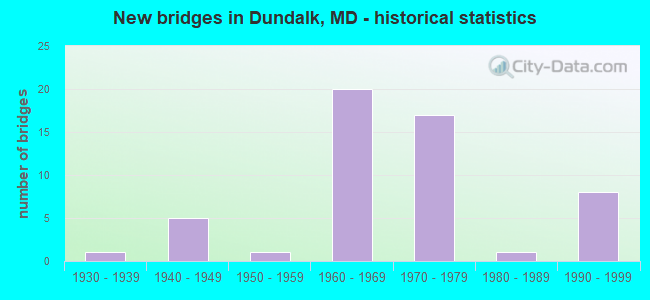
- New bridges - historical statistics
- 11930-1939
- 51940-1949
- 11950-1959
- 201960-1969
- 171970-1979
- 11980-1989
- 81990-1999
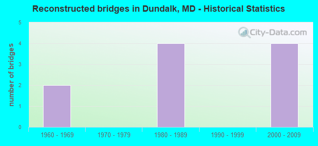
- Reconstructed bridges - Historical Statistics
- 21960-1969
- 01970-1979
- 41980-1989
- 01990-1999
- 42000-2009

- Bridge Condition - Deck
- 29.0%Good
- 61.3%Satisfactory
- 9.7%Fair
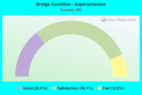
- Bridge Condition - Superstructure
- 29.0%Good
- 58.1%Satisfactory
- 12.9%Fair
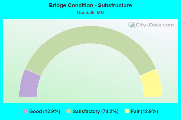
- Bridge Condition - Substructure
- 12.9%Good
- 74.2%Satisfactory
- 12.9%Fair
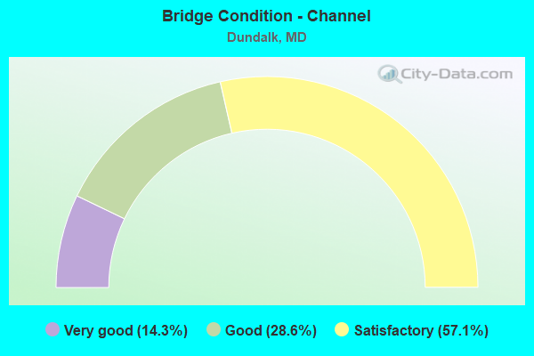
- Bridge Condition - Channel
- 14.3%Very good
- 28.6%Good
- 57.1%Satisfactory
Find on map >> Show street view
Structure Number: 10000003027201, Location: 1.32MILE NORTH OD MD 150 (Lat: 39.283342, Lng: -76.490108), Route carried "under" structure: State highway 695, Year Built: 1971, Structure Length: 0. m, Average Daily Traffic: 30,714 (year 2009), Features Intersected: MD 695, Facility Carried by Structure: MD 151
Minimum Vertical Clearance: 5.18m (16.99ft), Kilometerpoint: 8.817, Lanes on structure: 2, Lanes under structure: 5, Material/Design: Steel continuous, Design/Construction: Stringer/Multi-beam, Length of Maximum Span: 55.5m (182.1ft)
Find on map >> Show street view
Structure Number: 100000030290015, Location: 0.38 MI N OF MD 151 (Lat: 39.251508, Lng: -76.456628), Route carried "under" structure: County highway 5527, Year Built: 1974, Structure Length: 0. m, Average Daily Traffic: 999 (year 2012), Features Intersected: NORFOLK S'RN RR,MORSE LN, Facility Carried by Structure: MD 695 IL
Minimum Vertical Clearance: 5.49m (18.01ft), Kilometerpoint: 0.322, Lanes on structure: 2, Lanes under structure: 2, Material/Design: Steel continuous, Design/Construction: Stringer/Multi-beam, Length of Maximum Span: 58.5m (191.9ft)
Find on map >> Show street view
Structure Number: 100000030290016, Location: 0.38 MI N OF MD 151 (Lat: 39.250525, Lng: -76.455675), Route carried "under" structure: County highway 5527, Year Built: 1974, Structure Length: 0. m, Average Daily Traffic: 999 (year 2012), Features Intersected: NORFOLK S'RN RR,MORSE LN, Facility Carried by Structure: MD 695 OL
Minimum Vertical Clearance: 5.49m (18.01ft), Kilometerpoint: 0.386, Lanes on structure: 2, Lanes under structure: 2, Material/Design: Steel continuous, Design/Construction: Stringer/Multi-beam, Length of Maximum Span: 61.9m (203.1ft)
Find on map >> Show street view
Structure Number: 10000003037001, Location: 0.17 MILE NORTH OF MD 158 (Lat: 39.245694, Lng: -76.456103), Route carried "under" structure: State highway 151, Year Built: 1995, Structure Length: 0. m, Average Daily Traffic: 18,160 (year 2006), Truck Traffic: 8%, Features Intersected: MD 151, Facility Carried by Structure: MD 695
Minimum Vertical Clearance: 5.49m (18.01ft), Kilometerpoint: 3.041, Lanes on structure: 5, Lanes under structure: 5, Material/Design: Steel, Design/Construction: Stringer/Multi-beam, Length of Maximum Span: 47.2m (154.9ft)
Find on map >> Show street view
Structure Number: 300000B-Z448016, Location: 1.2 M west of Md 151 (Lat: 0.653889, Lng: -1.274494), Route carried "under" structure: State highway 157, Year Built: 1998, Structure Length: 0. m, Average Daily Traffic: 8,160 (year 2010), Truck Traffic: 3%, Features Intersected: Peninsula Expressway, Facility Carried by Structure: I-695 OL
Minimum Vertical Clearance: 5.79m (19.00ft), Kilometerpoint: 7.208, Lanes on structure: 2, Lanes under structure: 5, Material/Design: Steel, Design/Construction: Stringer/Multi-beam, Length of Maximum Span: 34.1m (111.9ft)