Bridge Statistics for East Chicago, Indiana (IN)
Condition, Traffic, Stress, Structural Evaluation, Project Costs
- National Bridge Inventory (NBI) Statistics
- 81Number of bridges
- 2,349ft / 716mTotal length
- $2,949,000Total costs
- 1,148,995Total average daily traffic
- 108,426Total average daily truck traffic
- National Bridge Inventory (NBI) Registered Bridges for East Chicago
- No street view available for this location
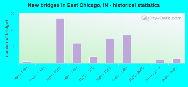
- New bridges - historical statistics
- 11930-1939
- 271950-1959
- 121960-1969
- 41970-1979
- 151980-1989
- 171990-1999
- 22010-2019
- 32020-2022
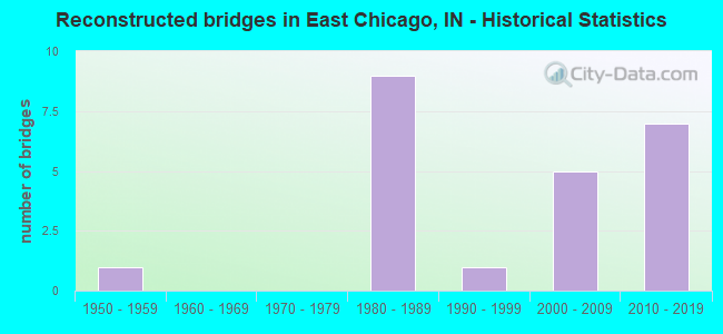
- Reconstructed bridges - Historical Statistics
- 11950-1959
- 01960-1969
- 01970-1979
- 91980-1989
- 11990-1999
- 52000-2009
- 72010-2019
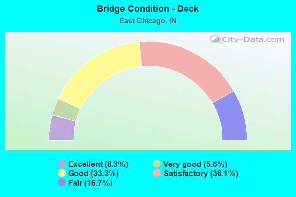
- Bridge Condition - Deck
- 8.3%Excellent
- 5.6%Very good
- 33.3%Good
- 36.1%Satisfactory
- 16.7%Fair
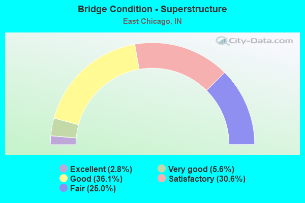
- Bridge Condition - Superstructure
- 2.8%Excellent
- 5.6%Very good
- 36.1%Good
- 30.6%Satisfactory
- 25.0%Fair
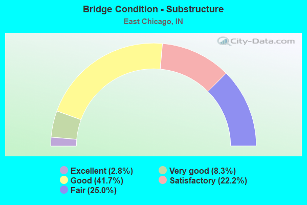
- Bridge Condition - Substructure
- 2.8%Excellent
- 8.3%Very good
- 41.7%Good
- 22.2%Satisfactory
- 25.0%Fair
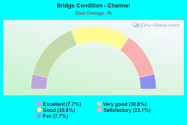
- Bridge Condition - Channel
- 7.7%Excellent
- 30.8%Very good
- 30.8%Good
- 23.1%Satisfactory
- 7.7%Fair
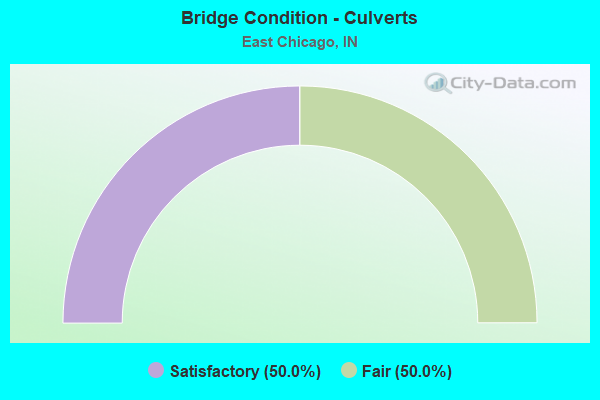
- Bridge Condition - Culverts
- 50.0%Satisfactory
- 50.0%Fair
Find on map >> Show street view
Structure Number: 4500233, Location: 0.1 S 145TH ST (Lat: 41.630669, Lng: -87.476169), Route carried "on" structure: City street , Year Built: 2014, Status: Open, Structure Length: 2.96m (9.71ft), Average Daily Traffic: 11,057 (year 2019), Truck Traffic: 5%, Average Future Daily Traffic: 13,627 (year 2040), Features Intersected: CSX RR, Facility Carried by Structure: RAILROAD AVENUE
Minimum Vertical Clearance: 30+ m (98+ ft), Kilometerpoint: 0.000, Lanes on structure: 4, Owner: City or Municipal Highway Agency, Approaching Roadway Width: 15.9m (52.2ft), Material/Design: Prestressed concrete, Design/Construction: Tee Beam, Number Of Spans In Main Unit: 1, Length of Maximum Span: 29.0m (95.1ft), Curb or Sidewalk Widths: Left: 2.0m (6.6ft), Right: 0.0m, Curb-To-Curb Width: 15.9m (52.2ft), Out-to-Out Width: 18.8m (61.7ft)
Condition: Deck: Satisfactory, Superstructure: Very good, Substructure: Very good, Operating Rating: 49.7 metric tons, Method Used To Determine Operating Rating: Load Factor (LF), Inventory Rating: 29.8 metric tons, Method Used To Determine Inventory Rating: Load Factor (LF), Structural Evaluation: Better than present minimum criteria, Deck Geometry: Meets minimum limits, Underclear: Superior to present desirable criteria, Approach Roadway Alignment: Equal to present desirable criteria, Designated Inspection Frequency: Every 24 months, Inspection Date: August 2020, Deck Structure Type: Concrete Cast-file-Place, Wearing Surface/Protective System: Wearing Surface: Integral Concrete, Deck Protection: Epoxy Coated Reinforcing
Find on map >> Show street view
Structure Number: 312, Location: 01.01 E US 20 (Lat: 41.639181, Lng: -87.461717), Route carried "under" structure: City street , Year Built: 1994, Structure Length: 0. m, Average Daily Traffic: 4,845 (year 2004), Truck Traffic: 5%, Features Intersected: KENNEDY AVE, Facility Carried by Structure: US 12
Minimum Vertical Clearance: 5.18m (16.99ft), Kilometerpoint: 0.000, Lanes on structure: 6, Lanes under structure: 4, Material/Design: Prestressed concrete continuous, Design/Construction: Stringer/Multi-beam, Length of Maximum Span: 22.9m (75.1ft)
Find on map >> Show street view
Structure Number: 313, Location: 01.19 E US 20 (Lat: 41.639139, Lng: -87.458764), Route carried "under" structure: Alternate City street , Year Built: 1994, Structure Length: 0. m, Average Daily Traffic: 118 (year 2004), Truck Traffic: 5%, Features Intersected: US 12, Facility Carried by Structure: CAREY ST
Minimum Vertical Clearance: 4.47m (14.67ft), Kilometerpoint: 0.000, Lanes on structure: 4, Lanes under structure: 2, Material/Design: Steel continuous, Design/Construction: Stringer/Multi-beam, Length of Maximum Span: 43.9m (144.0ft)
Find on map >> Show street view
Structure Number: 5195, Location: 00.01 E I-90 (Lat: 41.612481, Lng: -87.480689), Route carried "under" structure: US 20, Year Built: 1956, Structure Length: 0. m, Average Daily Traffic: 26,356 (year 2004), Truck Traffic: 10%, Features Intersected: US 20, Facility Carried by Structure: NICTD RR
Minimum Vertical Clearance: 4.55m (14.93ft), Kilometerpoint: 11.298, Lanes under structure: 5, Material/Design: Steel, Design/Construction: Girder and Floorbeam System, Length of Maximum Span: 35.1m (115.2ft)
Find on map >> Show street view
Structure Number: 33024, Location: 01.46 E US-41 (Lat: 41.655211, Lng: -87.481208), Route carried "under" structure: US 12, Year Built: 1986, Structure Length: 0. m, Average Daily Traffic: 13,265 (year 2004), Truck Traffic: 10%, Features Intersected: US-12/20
Minimum Vertical Clearance: 4.88m (16.01ft), Kilometerpoint: 6.679, Lanes on structure: 6, Lanes under structure: 4, Material/Design: Steel continuous, Design/Construction: Stringer/Multi-beam, Length of Maximum Span: 40.5m (132.9ft)
Find on map >> Show street view
Structure Number: 3303, Location: 01.66 E OF W JCT US-12 (Lat: 41.651239, Lng: -87.453225), Route carried "under" structure: ServiceCity street , Year Built: 1980, Structure Length: 0. m, Average Daily Traffic: 7,750 (year 2004), Truck Traffic: 10%, Features Intersected: DICKEY RD; RAILROAD, Facility Carried by Structure: DOCK STREET
Minimum Vertical Clearance: 6.96m (22.83ft), Kilometerpoint: 0.000, Lanes on structure: 6, Lanes under structure: 6, Material/Design: Steel continuous, Design/Construction: Stringer/Multi-beam, Length of Maximum Span: 44.5m (146.0ft)
Find on map >> Show street view
Structure Number: 3303, Location: 01.66 E OF W JCT US-12 (Lat: 41.651239, Lng: -87.453225), Route carried "under" structure: City street , Year Built: 1980, Structure Length: 0. m, Average Daily Traffic: 7,755 (year 2004), Truck Traffic: 40%, Features Intersected: DOCK STREET; RAILROAD, Facility Carried by Structure: DICKEY ROAD
Minimum Vertical Clearance: 6.96m (22.83ft), Kilometerpoint: 0.000, Lanes on structure: 6, Lanes under structure: 6, Material/Design: Steel continuous, Design/Construction: Stringer/Multi-beam, Length of Maximum Span: 44.5m (146.0ft)
Find on map >> Show street view
Structure Number: 33032, Location: 01.34 W US-12 (Lat: 41.652881, Lng: -87.443161), Route carried "under" structure: ServiceOther road , Year Built: 1959, Structure Length: 0. m, Average Daily Traffic: 50 (year 2004), Truck Traffic: 50%, Features Intersected: RR ACCESS ROAD - SOUTH, Facility Carried by Structure: MICHIGAN AVENUE
Minimum Vertical Clearance: 7.06m (23.16ft), Kilometerpoint: 7.242, Lanes on structure: 4, Lanes under structure: 12, Material/Design: Steel continuous, Design/Construction: Stringer/Multi-beam, Length of Maximum Span: 31.7m (104.0ft)
Find on map >> Show street view
Structure Number: 33032, Location: 01.34 W US-12 (Lat: 41.652881, Lng: -87.443161), Route carried "under" structure: State highway 912, Year Built: 1959, Structure Length: 0. m, Average Daily Traffic: 36,100 (year 2004), Truck Traffic: 20%, Features Intersected: SR-912 WBL, Facility Carried by Structure: MICHIGAN AVENUE
Minimum Vertical Clearance: 7.06m (23.16ft), Kilometerpoint: 7.242, Lanes on structure: 4, Lanes under structure: 12, Material/Design: Steel continuous, Design/Construction: Stringer/Multi-beam, Length of Maximum Span: 31.7m (104.0ft)
Find on map >> Show street view
Structure Number: 33032, Location: 01.34 W US-12 (Lat: 41.652881, Lng: -87.443161), Route carried "under" structure: State highway 912, Year Built: 1959, Structure Length: 0. m, Average Daily Traffic: 36,100 (year 2004), Truck Traffic: 20%, Features Intersected: SR-912 EBL, Facility Carried by Structure: MICHIGAN AVENUE
Minimum Vertical Clearance: 7.06m (23.16ft), Kilometerpoint: 7.242, Lanes on structure: 4, Lanes under structure: 12, Material/Design: Steel continuous, Design/Construction: Stringer/Multi-beam, Length of Maximum Span: 31.7m (104.0ft)
Find on map >> Show street view
Structure Number: 33032, Location: 01.34 W US-12 (Lat: 41.652881, Lng: -87.443161), Route carried "under" structure: ServiceOther road , Year Built: 1959, Structure Length: 0. m, Average Daily Traffic: 50 (year 2004), Truck Traffic: 50%, Features Intersected: RR ACCESS ROAD - MIDDLE, Facility Carried by Structure: MICHIGAN AVENUE
Minimum Vertical Clearance: 7.06m (23.16ft), Kilometerpoint: 7.242, Lanes on structure: 4, Lanes under structure: 12, Material/Design: Steel continuous, Design/Construction: Stringer/Multi-beam, Length of Maximum Span: 31.7m (104.0ft)
Find on map >> Show street view
Structure Number: 33032, Location: 01.34 W US-12 (Lat: 41.652881, Lng: -87.443161), Route carried "under" structure: Ramp Other road , Year Built: 1959, Structure Length: 0. m, Average Daily Traffic: 50 (year 2004), Truck Traffic: 50%, Features Intersected: RR ACCESS ROAD - NORTH, Facility Carried by Structure: MICHIGAN AVENUE
Minimum Vertical Clearance: 7.06m (23.16ft), Kilometerpoint: 7.242, Lanes on structure: 4, Lanes under structure: 12, Material/Design: Steel continuous, Design/Construction: Stringer/Multi-beam, Length of Maximum Span: 31.7m (104.0ft)
Find on map >> Show street view
Structure Number: 33035, Location: 01.33 W US-12 (Lat: 41.651931, Lng: -87.444092), Route carried "under" structure: Ramp State highway 912, Year Built: 1959, Structure Length: 0. m, Average Daily Traffic: 2,452 (year 2004), Truck Traffic: 10%, Features Intersected: RAMP B, Facility Carried by Structure: RAMP B
Minimum Vertical Clearance: 4.75m (15.58ft), Kilometerpoint: 7.258, Lanes on structure: 1, Lanes under structure: 1, Material/Design: Concrete, Design/Construction: Frame, Length of Maximum Span: 14.3m (46.9ft)
Find on map >> Show street view
Structure Number: 33036, Location: 01.33 W US-12 (Lat: 41.651911, Lng: -87.444244), Route carried "under" structure: Ramp State highway 912, Year Built: 1980, Structure Length: 0. m, Average Daily Traffic: 2,452 (year 2004), Truck Traffic: 10%, Features Intersected: RAMP H, Facility Carried by Structure: RAMP B
Minimum Vertical Clearance: 5.08m (16.67ft), Kilometerpoint: 7.274, Lanes on structure: 1, Lanes under structure: 1, Material/Design: Prestressed concrete, Design/Construction: Box Beam or Girders - Multiple, Length of Maximum Span: 15.8m (51.8ft)
Find on map >> Show street view
Structure Number: 33039, Location: 00.32 W US 12 (Lat: 41.640611, Lng: -87.431792), Route carried "under" structure: City street 912, Year Built: 1980, Structure Length: 0. m, Average Daily Traffic: 2,000 (year 2011), Truck Traffic: 11%, Features Intersected: GUTHRIE ST. EB
Minimum Vertical Clearance: 4.78m (15.68ft), Kilometerpoint: 0.000, Lanes on structure: 6, Lanes under structure: 3, Material/Design: Steel continuous, Design/Construction: Stringer/Multi-beam, Length of Maximum Span: 19.7m (64.6ft)
Find on map >> Show street view
Structure Number: 33039, Location: 00.32 W US 12 (Lat: 41.640611, Lng: -87.431792), Route carried "under" structure: State highway 912, Year Built: 1980, Structure Length: 0. m, Average Daily Traffic: 41,775 (year 2011), Truck Traffic: 11%, Features Intersected: Guthrie St. WB
Minimum Vertical Clearance: 4.78m (15.68ft), Kilometerpoint: 0.000, Lanes on structure: 6, Lanes under structure: 3, Material/Design: Steel continuous, Design/Construction: Stringer/Multi-beam, Length of Maximum Span: 19.7m (64.6ft)
Find on map >> Show street view
Structure Number: 3304, Location: 00.52 W SR-312 (Lat: 41.636331, Lng: -87.432022), Route carried "under" structure: US 12, Year Built: 1970, Structure Length: 0. m, Average Daily Traffic: 7,750 (year 2010), Truck Traffic: 5%, Features Intersected: US-12 (INDSTR. HWY) WBL
Minimum Vertical Clearance: 4.93m (16.17ft), Kilometerpoint: 3.718, Lanes on structure: 2, Lanes under structure: 6, Material/Design: Steel continuous, Design/Construction: Stringer/Multi-beam, Length of Maximum Span: 27.3m (89.6ft)
Find on map >> Show street view
Structure Number: 3304, Location: 00.52 W SR-312 (Lat: 41.636331, Lng: -87.432022), Route carried "under" structure: County highway , Year Built: 1970, Structure Length: 0. m, Average Daily Traffic: 7,750 (year 2010), Truck Traffic: 5%, Features Intersected: INDUSTRIAL HIGHWAY EBL, Facility Carried by Structure: SR 912 EB
Minimum Vertical Clearance: 4.93m (16.17ft), Kilometerpoint: 3.718, Lanes on structure: 2, Lanes under structure: 6, Material/Design: Steel continuous, Design/Construction: Stringer/Multi-beam, Length of Maximum Span: 27.3m (89.6ft)
Find on map >> Show street view
Structure Number: 3306, Location: 01.27 W I-90 (Lat: 41.628850, Lng: -87.432219), Route carried "under" structure: Ramp State highway 912, Year Built: 1965, Structure Length: 0. m, Average Daily Traffic: 2,000 (year 2004), Truck Traffic: 10%, Features Intersected: SR-912 SOUTH-NORTH RAMP
Minimum Vertical Clearance: 5.77m (18.93ft), Kilometerpoint: 8.224, Lanes on structure: 6, Lanes under structure: 8, Material/Design: Steel continuous, Design/Construction: Stringer/Multi-beam, Length of Maximum Span: 31.7m (104.0ft)
Find on map >> Show street view
Structure Number: 3306, Location: 01.27 W I-90 (Lat: 41.628850, Lng: -87.432219), Route carried "under" structure: Ramp State highway 912, Year Built: 1965, Structure Length: 0. m, Average Daily Traffic: 2,000 (year 2004), Truck Traffic: 10%, Features Intersected: SR-912 NORTH-SOUTH RAMP
Minimum Vertical Clearance: 5.77m (18.93ft), Kilometerpoint: 8.224, Lanes on structure: 6, Lanes under structure: 8, Material/Design: Steel continuous, Design/Construction: Stringer/Multi-beam, Length of Maximum Span: 31.7m (104.0ft)
Find on map >> Show street view
Structure Number: 3306, Location: 01.27 W I-90 (Lat: 41.628850, Lng: -87.432219), Route carried "under" structure: State highway 312, Year Built: 1965, Structure Length: 0. m, Average Daily Traffic: 5,091 (year 2004), Truck Traffic: 20%, Features Intersected: SR-312, Facility Carried by Structure: US 12/SR 912
Minimum Vertical Clearance: 5.77m (18.93ft), Kilometerpoint: 8.224, Lanes on structure: 6, Lanes under structure: 8, Material/Design: Steel continuous, Design/Construction: Stringer/Multi-beam, Length of Maximum Span: 31.7m (104.0ft)
Find on map >> Show street view
Structure Number: 3308, Location: 00.49 W I-90 (Lat: 41.617189, Lng: -87.432075), Route carried "under" structure: ServiceOther road , Year Built: 1965, Structure Length: 0. m, Average Daily Traffic: 50 (year 2004), Truck Traffic: 50%, Features Intersected: US 12/SR 912, Facility Carried by Structure: ACCESS RD
Minimum Vertical Clearance: 6.76m (22.18ft), Kilometerpoint: 0.000, Lanes on structure: 5, Lanes under structure: 2, Material/Design: Steel, Design/Construction: Stringer/Multi-beam, Length of Maximum Span: 24.0m (78.7ft)
Find on map >> Show street view
Structure Number: 3308, Location: 00.49 W I-90 (Lat: 41.617189, Lng: -87.432075), Route carried "under" structure: City street , Year Built: 1965, Structure Length: 0. m, Average Daily Traffic: 118 (year 2004), Truck Traffic: 25%, Features Intersected: US 12/SR 912, Facility Carried by Structure: GARY AVE EB
Minimum Vertical Clearance: 6.76m (22.18ft), Kilometerpoint: 0.000, Lanes on structure: 5, Lanes under structure: 2, Material/Design: Steel, Design/Construction: Stringer/Multi-beam, Length of Maximum Span: 24.0m (78.7ft)
Find on map >> Show street view
Structure Number: 3308, Location: 00.49 W I-90 (Lat: 41.617189, Lng: -87.432075), Route carried "under" structure: City street , Year Built: 1965, Structure Length: 0. m, Average Daily Traffic: 118 (year 2004), Truck Traffic: 25%, Features Intersected: US 12/SR 912, Facility Carried by Structure: GARY AVE WB
Minimum Vertical Clearance: 6.76m (22.18ft), Kilometerpoint: 0.000, Lanes on structure: 5, Lanes under structure: 2, Material/Design: Steel, Design/Construction: Stringer/Multi-beam, Length of Maximum Span: 24.0m (78.7ft)
Find on map >> Show street view
Structure Number: 3309, Location: 00.19 W I-90 (Lat: 41.613119, Lng: -87.432258), Route carried "under" structure: ServiceOther road , Year Built: 1965, Structure Length: 0. m, Average Daily Traffic: 10 (year 2004), Truck Traffic: 5%, Features Intersected: SOUTH PRIVATE ROAD, Facility Carried by Structure: US 12/SR 912
Minimum Vertical Clearance: 4.47m (14.67ft), Kilometerpoint: 0.000, Lanes on structure: 5, Lanes under structure: 4, Material/Design: Steel continuous, Design/Construction: Stringer/Multi-beam, Length of Maximum Span: 24.1m (79.1ft)
Find on map >> Show street view
Structure Number: 3309, Location: 00.19 W I-90 (Lat: 41.613119, Lng: -87.432258), Route carried "under" structure: ServiceCity street , Year Built: 1965, Structure Length: 0. m, Average Daily Traffic: 118 (year 2004), Truck Traffic: 5%, Features Intersected: NORTH ACCESS ROAD, Facility Carried by Structure: US 12/SR 912
Minimum Vertical Clearance: 4.47m (14.67ft), Kilometerpoint: 0.000, Lanes on structure: 5, Lanes under structure: 4, Material/Design: Steel continuous, Design/Construction: Stringer/Multi-beam, Length of Maximum Span: 24.1m (79.1ft)
Find on map >> Show street view
Structure Number: 4619, Location: 00.44 W US 20 (Lat: 41.617369, Lng: -87.489136), Route carried "under" structure: City street , Year Built: 1956, Structure Length: 0. m, Average Daily Traffic: 133 (year 2004), Truck Traffic: 5%, Features Intersected: GR CALUMET RIV, DR, 2 RR, Facility Carried by Structure: I-90 EB
Minimum Vertical Clearance: 7.11m (23.33ft), Kilometerpoint: 0.000, Lanes on structure: 2, Lanes under structure: 2, Material/Design: Steel continuous, Design/Construction: Stringer/Multi-beam, Length of Maximum Span: 52.7m (172.9ft)
Find on map >> Show street view
Structure Number: 462, Location: 00.44 W US 20 (Lat: 41.617439, Lng: -87.489014), Route carried "under" structure: City street , Year Built: 1956, Structure Length: 0. m, Average Daily Traffic: 133 (year 2004), Truck Traffic: 5%, Features Intersected: ROXANA DR, Facility Carried by Structure: I-90 WB
Minimum Vertical Clearance: 6.71m (22.01ft), Kilometerpoint: 0.000, Lanes on structure: 2, Lanes under structure: 2, Material/Design: Steel continuous, Design/Construction: Stringer/Multi-beam, Length of Maximum Span: 53.6m (175.9ft)
Find on map >> Show street view
Structure Number: 4621, Location: 01.51 E SR 312 (Lat: 41.612681, Lng: -87.480689), Route carried "under" structure: US 20, Year Built: 1956, Structure Length: 0. m, Average Daily Traffic: 33,210 (year 2004), Truck Traffic: 5%, Features Intersected: US 20/SR 152/INDY BLV, Facility Carried by Structure: I-90 EB
Minimum Vertical Clearance: 4.55m (14.93ft), Kilometerpoint: 11.265, Lanes on structure: 2, Lanes under structure: 5, Toll: On toll road, Material/Design: Steel, Design/Construction: Stringer/Multi-beam, Length of Maximum Span: 34.4m (112.9ft)
Find on map >> Show street view
Structure Number: 4622, Location: 01.51 E SR 312 (Lat: 41.612811, Lng: -87.480689), Route carried "under" structure: US 20, Year Built: 1956, Structure Length: 0. m, Average Daily Traffic: 33,210 (year 2004), Truck Traffic: 5%, Features Intersected: US 20/SR 152, Facility Carried by Structure: I-90 WB
Minimum Vertical Clearance: 4.55m (14.93ft), Kilometerpoint: 11.282, Lanes on structure: 2, Lanes under structure: 4, Material/Design: Steel, Design/Construction: Stringer/Multi-beam, Length of Maximum Span: 34.4m (112.9ft)
Find on map >> Show street view
Structure Number: 4623, Location: 00.52 E US 20 (Lat: 41.610881, Lng: -87.471153), Route carried "under" structure: ServiceOther road , Year Built: 1956, Structure Length: 0. m, Average Daily Traffic: 133 (year 2004), Truck Traffic: 5%, Features Intersected: NIPSCO ACCESS ROAD, Facility Carried by Structure: I-90 EB
Minimum Vertical Clearance: 4.32m (14.17ft), Kilometerpoint: 0.000, Lanes on structure: 2, Lanes under structure: 2, Toll: On toll road, Material/Design: Steel, Design/Construction: Stringer/Multi-beam, Length of Maximum Span: 10.1m (33.1ft)
Find on map >> Show street view
Structure Number: 4624, Location: 00.52 E US 20 (Lat: 41.611000, Lng: -87.471153), Route carried "under" structure: ServiceOther road , Year Built: 1956, Structure Length: 0. m, Average Daily Traffic: 133 (year 2004), Truck Traffic: 5%, Features Intersected: NIPSCO ACCESS ROAD, Facility Carried by Structure: I-90 WB
Minimum Vertical Clearance: 3.89m (12.76ft), Kilometerpoint: 0.000, Lanes on structure: 2, Lanes under structure: 2, Toll: On toll road, Material/Design: Steel, Design/Construction: Stringer/Multi-beam, Length of Maximum Span: 10.1m (33.1ft)
Find on map >> Show street view
Structure Number: 4625, Location: 01.01 E US 20 (Lat: 41.610819, Lng: -87.461450), Route carried "under" structure: City street , Year Built: 1956, Structure Length: 0. m, Average Daily Traffic: 15,504 (year 2004), Truck Traffic: 5%, Features Intersected: KENNEDY AVE, Facility Carried by Structure: I-90 EB
Minimum Vertical Clearance: 7.62m (25.00ft), Kilometerpoint: 0.000, Lanes on structure: 2, Lanes under structure: 4, Toll: On toll road, Material/Design: Steel, Design/Construction: Stringer/Multi-beam, Length of Maximum Span: 20.1m (65.9ft)
Find on map >> Show street view
Structure Number: 4626, Location: 01.01 E US 20 (Lat: 41.610931, Lng: -87.461450), Route carried "under" structure: City street , Year Built: 1956, Structure Length: 0. m, Average Daily Traffic: 15,504 (year 2004), Truck Traffic: 5%, Features Intersected: KENNEDY AVE, Facility Carried by Structure: I-90 WB
Minimum Vertical Clearance: 7.62m (25.00ft), Kilometerpoint: 0.000, Lanes on structure: 2, Lanes under structure: 2, Material/Design: Steel, Design/Construction: Stringer/Multi-beam, Length of Maximum Span: 20.1m (65.9ft)
Find on map >> Show street view
Structure Number: 4627, Location: 02.04 W US 12 (Lat: 41.610339, Lng: -87.432778), Route carried "under" structure: Interstate 90, Year Built: 1956, Structure Length: 0. m, Average Daily Traffic: 20,365 (year 2015), Truck Traffic: 14%, Features Intersected: I-90 WB, Facility Carried by Structure: CSS & SB RR
Minimum Vertical Clearance: 6.35m (20.83ft), Kilometerpoint: 15.305, Lanes under structure: 2, Toll: On toll road, Material/Design: Steel, Design/Construction: Girder and Floorbeam System, Length of Maximum Span: 34.7m (113.8ft)
Find on map >> Show street view
Structure Number: 4627, Location: 02.04 W US 12 (Lat: 41.610339, Lng: -87.432778), Route carried "under" structure: Interstate 90, Year Built: 1956, Structure Length: 0. m, Average Daily Traffic: 20,365 (year 2015), Truck Traffic: 14%, Features Intersected: I-90 EB, Facility Carried by Structure: CSS & SB RR
Minimum Vertical Clearance: 6.35m (20.83ft), Kilometerpoint: 15.305, Lanes under structure: 2, Toll: On toll road, Material/Design: Steel, Design/Construction: Girder and Floorbeam System, Length of Maximum Span: 34.7m (113.8ft)
Find on map >> Show street view
Structure Number: 7645, Location: 00.86 W US-12 (Lat: 41.648669, Lng: -87.437392), Route carried "under" structure: Ramp State highway 912, Year Built: 1998, Structure Length: 0. m, Average Daily Traffic: 20,849 (year 2004), Truck Traffic: 10%, Features Intersected: SR-912 WBL EXIT RAMP
Minimum Vertical Clearance: 5.13m (16.83ft), Kilometerpoint: 8.015, Lanes on structure: 1, Lanes under structure: 1, Material/Design: Steel continuous, Design/Construction: Stringer/Multi-beam, Length of Maximum Span: 34.8m (114.2ft)
Find on map >> Show street view
Structure Number: 76451, Location: 00.84 W US-12 (Lat: 41.648881, Lng: -87.436469), Route carried "under" structure: ServiceOther road , Year Built: 1998, Structure Length: 0. m, Average Daily Traffic: 104 (year 2004), Truck Traffic: 25%, Features Intersected: RR ACCESS ROAD, Facility Carried by Structure: SR 912 MARINA ACC
Minimum Vertical Clearance: 8.28m (27.17ft), Kilometerpoint: 0.000, Lanes on structure: 2, Lanes under structure: 2, Material/Design: Steel continuous, Design/Construction: Stringer/Multi-beam, Length of Maximum Span: 36.5m (119.8ft)
Find on map >> Show street view
Structure Number: 76453, Location: 00.82 W US-12 (Lat: 41.648181, Lng: -87.437181), Route carried "under" structure: State highway 912, Year Built: 1998, Structure Length: 0. m, Average Daily Traffic: 36,100 (year 2004), Truck Traffic: 20%, Features Intersected: SR-912 WBL
Minimum Vertical Clearance: 5.16m (16.93ft), Kilometerpoint: 8.079, Lanes on structure: 1, Lanes under structure: 8, Material/Design: Steel continuous, Design/Construction: Stringer/Multi-beam, Length of Maximum Span: 48.3m (158.5ft)
Find on map >> Show street view
Structure Number: 76453, Location: 00.82 W US-12 (Lat: 41.648181, Lng: -87.437181), Route carried "under" structure: Ramp State highway 912, Year Built: 1998, Structure Length: 0. m, Average Daily Traffic: 8,000 (year 2004), Truck Traffic: 20%, Features Intersected: SR-912 WBL EXIT RAMP
Minimum Vertical Clearance: 5.16m (16.93ft), Kilometerpoint: 8.079, Lanes on structure: 1, Lanes under structure: 8, Material/Design: Steel continuous, Design/Construction: Stringer/Multi-beam, Length of Maximum Span: 48.3m (158.5ft)
Find on map >> Show street view
Structure Number: 76453, Location: 00.82 W US-12 (Lat: 41.648181, Lng: -87.437181), Route carried "under" structure: State highway 912, Year Built: 1998, Structure Length: 0. m, Average Daily Traffic: 36,100 (year 2004), Truck Traffic: 20%, Features Intersected: SR-912 EBL
Minimum Vertical Clearance: 5.16m (16.93ft), Kilometerpoint: 8.079, Lanes on structure: 1, Lanes under structure: 8, Material/Design: Steel continuous, Design/Construction: Stringer/Multi-beam, Length of Maximum Span: 48.3m (158.5ft)
Find on map >> Show street view
Structure Number: 76454, Location: 00.81 W US-12 (Lat: 41.648561, Lng: -87.436531), Route carried "under" structure: ServiceOther road , Year Built: 1998, Structure Length: 0. m, Average Daily Traffic: 104 (year 2004), Truck Traffic: 50%, Features Intersected: RR ACCESS ROAD, Facility Carried by Structure: SR 912 MARINA ACC
Minimum Vertical Clearance: 7.01m (23.00ft), Kilometerpoint: 0.000, Lanes on structure: 1, Lanes under structure: 2, Material/Design: Steel continuous, Design/Construction: Stringer/Multi-beam, Length of Maximum Span: 45.2m (148.3ft)
Find on map >> Show street view
Structure Number: 80777, Location: 01.66 E OF W JCT US-12 (Lat: 41.653531, Lng: -87.471811), Route carried "under" structure: City street , Year Built: 2020, Structure Length: 0. m, Average Daily Traffic: 5,340 (year 2009), Truck Traffic: 30%, Features Intersected: RILEY ROAD, Facility Carried by Structure: Riley Road
Minimum Vertical Clearance: 15.55m (51.02ft), Kilometerpoint: 0.000, Lanes on structure: 6, Lanes under structure: 4, Material/Design: Prestressed concrete continuous, Design/Construction: Segmental Box Girder, Length of Maximum Span: 95.9m (314.6ft)
Find on map >> Show street view
Structure Number: 80777, Location: 01.66 E OF W JCT US-12 (Lat: 41.648350, Lng: -87.457000), Route carried "under" structure: ServiceCity street , Year Built: 2020, Structure Length: 0. m, Average Daily Traffic: 7,750 (year 2004), Truck Traffic: 10%, Features Intersected: DOCK STREET, Facility Carried by Structure: Dock Street
Minimum Vertical Clearance: 6.71m (22.01ft), Kilometerpoint: 0.000, Lanes on structure: 6, Lanes under structure: 2, Material/Design: Prestressed concrete continuous, Design/Construction: Segmental Box Girder, Length of Maximum Span: 95.9m (314.6ft)