Bridge Statistics for East Moline, Illinois (IL)
Condition, Traffic, Stress, Structural Evaluation, Project Costs
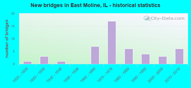
- New bridges - historical statistics
- 11920-1929
- 31930-1939
- 11940-1949
- 71960-1969
- 171970-1979
- 61980-1989
- 41990-1999
- 32000-2009
- 62010-2019
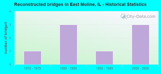
- Reconstructed bridges - Historical Statistics
- 11970-1979
- 31980-1989
- 11990-1999
- 32000-2009

- Bridge Condition - Deck
- 8.0%Very good
- 40.0%Good
- 48.0%Satisfactory
- 4.0%Fair
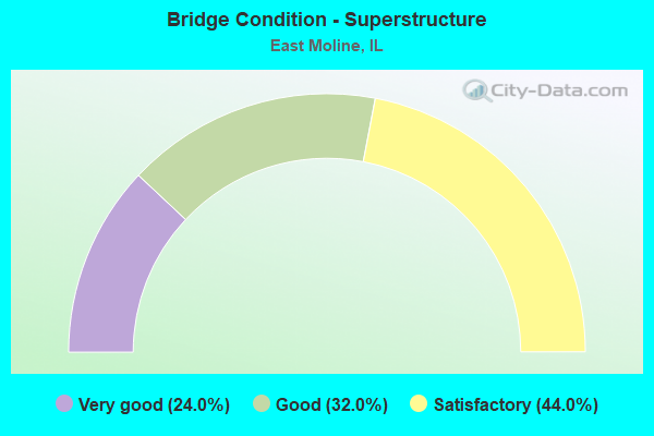
- Bridge Condition - Superstructure
- 24.0%Very good
- 32.0%Good
- 44.0%Satisfactory
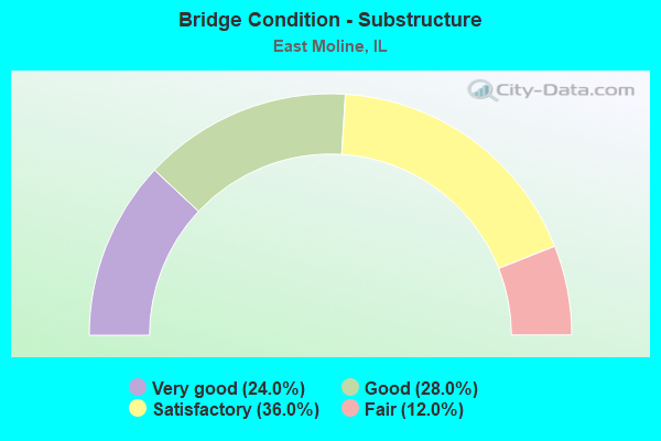
- Bridge Condition - Substructure
- 24.0%Very good
- 28.0%Good
- 36.0%Satisfactory
- 12.0%Fair
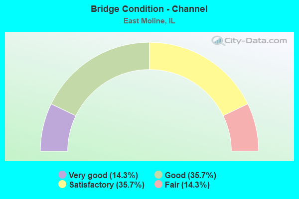
- Bridge Condition - Channel
- 14.3%Very good
- 35.7%Good
- 35.7%Satisfactory
- 14.3%Fair

- Bridge Condition - Culverts
- 14.3%Very good
- 64.3%Good
- 14.3%Satisfactory
- 7.1%Fair
Find on map >> Show street view
Structure Number: 370021, Location: AT ROCK ISLAND CO LN (Lat: 41.511019, Lng: -90.341108), Route carried "on" structure: Interstate 80, Year Built: 1965, Year Reconstructed: 1991, Status: Open, Structure Length: 36.15m (118.60ft), Average Daily Traffic: 11,500 (year 2021), Truck Traffic: 35%, Average Future Daily Traffic: 15,000 (year 2040), Design Load: HS 20, Features Intersected: ROCK RIVER
Minimum Vertical Clearance: 30+ m (98+ ft), Kilometerpoint: 8.417, Lanes on structure: 2, Base Highway Network: Yes, Owner: State Highway Agency, Approaching Roadway Width: 13.4m (44.0ft), Skew: 1 degrees, Navigation Control: Yes ( Vertical Clearance: 7.3m (24.0ft), Horizontal Clearance: 32.0m (105.0ft)), Material/Design: Steel, Design/Construction: Stringer/Multi-beam, Number Of Spans In Main Unit: 11, Length of Maximum Span: 32.9m (107.9ft), Curb-To-Curb Width: 12.8m (42.0ft), Out-to-Out Width: 13.8m (45.3ft)
Condition: Deck: Satisfactory, Superstructure: Satisfactory, Substructure: Fair, Channel: Satisfactory, Operating Rating: 69.7 metric tons, Method Used To Determine Operating Rating: Load Factor (LF) rating reported by rating factor (RF) method using MS18 loading, Inventory Rating: 41.8 metric tons, Method Used To Determine Inventory Rating: Load Factor (LF) rating reported by rating factor (RF) method using MS18 loading, Structural Evaluation: Somewhat better than minimum adequacy, Deck Geometry: Equal to present desirable criteria, Waterway Adequacy: Equal to present desirable criteria, Approach Roadway Alignment: Equal to present desirable criteria, Designated Inspection Frequency: Every 24 months, Underwater Inspection Frequency: Every 24 months, Inspection Date: July 2020, Underwater Inspection Date: September 2021, Deck Structure Type: Concrete Cast-file-Place, Wearing Surface/Protective System: Deck Protection: Epoxy Coated Reinforcing
Find on map >> Show street view
Structure Number: 370022, Location: AT ROCK ISLAND CO LN (Lat: 41.511019, Lng: -90.341108), Route carried "on" structure: Interstate 80, Year Built: 1965, Year Reconstructed: 1992, Status: Open, Structure Length: 36.15m (118.60ft), Average Daily Traffic: 11,500 (year 2021), Truck Traffic: 35%, Average Future Daily Traffic: 15,000 (year 2040), Design Load: HS 20, Features Intersected: ROCK RIVER
Minimum Vertical Clearance: 30+ m (98+ ft), Kilometerpoint: 8.417, Lanes on structure: 2, Base Highway Network: Yes, Owner: State Highway Agency, Approaching Roadway Width: 13.4m (44.0ft), Skew: 1 degrees, Navigation Control: Yes ( Vertical Clearance: 7.3m (24.0ft), Horizontal Clearance: 32.0m (105.0ft)), Material/Design: Steel, Design/Construction: Stringer/Multi-beam, Number Of Spans In Main Unit: 11, Length of Maximum Span: 32.9m (107.9ft), Curb-To-Curb Width: 12.8m (42.0ft), Out-to-Out Width: 13.8m (45.3ft)
Condition: Deck: Fair, Superstructure: Satisfactory, Substructure: Satisfactory, Channel: Satisfactory, Operating Rating: 69.7 metric tons, Method Used To Determine Operating Rating: Load Factor (LF) rating reported by rating factor (RF) method using MS18 loading, Inventory Rating: 41.8 metric tons, Method Used To Determine Inventory Rating: Load Factor (LF) rating reported by rating factor (RF) method using MS18 loading, Structural Evaluation: Equal to present minimum criteria, Deck Geometry: Equal to present desirable criteria, Waterway Adequacy: Equal to present desirable criteria, Approach Roadway Alignment: Equal to present desirable criteria, Designated Inspection Frequency: Every 24 months, Underwater Inspection Frequency: Every 24 months, Inspection Date: July 2020, Underwater Inspection Date: September 2021, Deck Structure Type: Concrete Cast-file-Place, Wearing Surface/Protective System: Deck Protection: Epoxy Coated Reinforcing
Find on map >> Show street view
Structure Number: 373219, Location: 5.0 MI NW GENESEO (Lat: 41.478483, Lng: -90.260275), Route carried "on" structure: County highway , Year Built: 1975, Status: Open, Structure Length: 7.13m (23.39ft), Average Daily Traffic: 550 (year 2020), Truck Traffic: 25%, Average Future Daily Traffic: 450 (year 2040), Design Load: HS 15, Features Intersected: GREEN RIVER, Facility Carried by Structure: CH 13 FAS 1221
Minimum Vertical Clearance: 30+ m (98+ ft), Kilometerpoint: 2.543, Lanes on structure: 2, Owner: County Highway Agency, Approaching Roadway Width: 11.0m (36.1ft), Material/Design: Prestressed concrete, Design/Construction: Box Beam or Girders - Multiple, Number Of Spans In Main Unit: 3, Length of Maximum Span: 23.5m (77.1ft), Curb-To-Curb Width: 9.0m (29.5ft), Out-to-Out Width: 9.1m (29.9ft)
Condition: Deck: Satisfactory, Superstructure: Satisfactory, Substructure: Satisfactory, Channel: Fair, Operating Rating: 59.3 metric tons, Method Used To Determine Operating Rating: Load Factor (LF) rating reported by rating factor (RF) method using MS18 loading, Inventory Rating: 35.6 metric tons, Method Used To Determine Inventory Rating: Load Factor (LF) rating reported by rating factor (RF) method using MS18 loading, Structural Evaluation: Equal to present minimum criteria, Deck Geometry: Somewhat better than minimum adequacy, Waterway Adequacy: Equal to present desirable criteria, Approach Roadway Alignment: Equal to present desirable criteria, Designated Inspection Frequency: Every 24 months, Inspection Date: August 2020, Deck Structure Type: Concrete Precast Panels, Wearing Surface/Protective System: Wearing Surface: Bituminous
Find on map >> Show street view
Structure Number: 810012, Location: 2.5 MI NE SILVIS (Lat: 41.536058, Lng: -90.341769), Route carried "on" structure: Interstate 80, Year Built: 1965, Year Reconstructed: 2008, Status: Open, Structure Length: 5.96m (19.55ft), Average Daily Traffic: 16,350 (year 2021), Truck Traffic: 35%, Average Future Daily Traffic: 20,500 (year 2040), Design Load: HS 20+Mod, Features Intersected: I-88 & IL 92
Minimum Vertical Clearance: 30+ m (98+ ft), Kilometerpoint: 5.600, Lanes on structure: 2, Lanes under structure: 4, Base Highway Network: Yes, Owner: State Highway Agency, Approaching Roadway Width: 16.5m (54.1ft), Skew: 1 degrees, Material/Design: Steel continuous, Design/Construction: Stringer/Multi-beam, Number Of Spans In Main Unit: 4, Length of Maximum Span: 17.7m (58.1ft), Curb-To-Curb Width: 15.9m (52.2ft), Out-to-Out Width: 16.9m (55.4ft)
Condition: Deck: Satisfactory, Superstructure: Satisfactory, Substructure: Satisfactory, Operating Rating: 67.1 metric tons, Method Used To Determine Operating Rating: Load Factor (LF) rating reported by rating factor (RF) method using MS18 loading, Inventory Rating: 40.2 metric tons, Method Used To Determine Inventory Rating: Load Factor (LF) rating reported by rating factor (RF) method using MS18 loading, Structural Evaluation: Equal to present minimum criteria, Deck Geometry: Superior to present desirable criteria, Underclear: High priority of corrective action, Approach Roadway Alignment: Equal to present desirable criteria, Length Of Structure Improvement: 5.97m (19.59ft), Designated Inspection Frequency: Every 24 months, Inspection Date: December 2020, Bridge Improvement Cost: $263,000, Roadway Improvement Cost: $13,000, Total Project Cost: $316,000, Deck Structure Type: Concrete Cast-file-Place, Wearing Surface/Protective System: Deck Protection: Epoxy Coated Reinforcing
Find on map >> Show street view
Structure Number: 810013, Location: 2.5 MI NE SILVIS (Lat: 41.535911, Lng: -90.341781), Route carried "on" structure: Interstate 80, Year Built: 1965, Year Reconstructed: 2008, Status: Open, Structure Length: 5.96m (19.55ft), Average Daily Traffic: 11,500 (year 2021), Truck Traffic: 35%, Average Future Daily Traffic: 14,400 (year 2040), Design Load: HS 20+Mod, Features Intersected: I-88 & IL 92
Minimum Vertical Clearance: 30+ m (98+ ft), Kilometerpoint: 5.616, Lanes on structure: 2, Lanes under structure: 4, Base Highway Network: Yes, Owner: State Highway Agency, Approaching Roadway Width: 16.5m (54.1ft), Skew: 1 degrees, Material/Design: Steel continuous, Design/Construction: Stringer/Multi-beam, Number Of Spans In Main Unit: 4, Length of Maximum Span: 17.7m (58.1ft), Curb-To-Curb Width: 15.9m (52.2ft), Out-to-Out Width: 16.9m (55.4ft)
Condition: Deck: Satisfactory, Superstructure: Satisfactory, Substructure: Satisfactory, Operating Rating: 67.1 metric tons, Method Used To Determine Operating Rating: Load Factor (LF) rating reported by rating factor (RF) method using MS18 loading, Inventory Rating: 40.2 metric tons, Method Used To Determine Inventory Rating: Load Factor (LF) rating reported by rating factor (RF) method using MS18 loading, Structural Evaluation: Equal to present minimum criteria, Deck Geometry: Superior to present desirable criteria, Underclear: High priority of corrective action, Approach Roadway Alignment: Equal to present desirable criteria, Length Of Structure Improvement: 5.97m (19.59ft), Designated Inspection Frequency: Every 24 months, Inspection Date: December 2020, Bridge Improvement Cost: $211,000, Roadway Improvement Cost: $21,000, Total Project Cost: $253,000, Deck Structure Type: Concrete Cast-file-Place, Wearing Surface/Protective System: Deck Protection: Epoxy Coated Reinforcing
Find on map >> Show street view
Structure Number: 810034, Location: 5.5 MI SW HILLSDALE (Lat: 41.571350, Lng: -90.254906), Route carried "on" structure: County highway , Year Built: 1923, Year Reconstructed: 2006, Status: Open, Structure Length: 1.31m (4.30ft), Average Daily Traffic: 675 (year 2020), Truck Traffic: 31%, Average Future Daily Traffic: 900 (year 2040), Design Load: HS 20, Features Intersected: ZUMA CREEK, Facility Carried by Structure: MOLINE RD (OLD IL2
Minimum Vertical Clearance: 30+ m (98+ ft), Kilometerpoint: 10.219, Lanes on structure: 2, Owner: State Highway Agency, Approaching Roadway Width: 7.9m (25.9ft), Material/Design: Prestressed concrete, Design/Construction: Box Beam or Girders - Multiple, Number Of Spans In Main Unit: 1, Length of Maximum Span: 12.5m (41.0ft), Curb-To-Curb Width: 9.8m (32.2ft), Out-to-Out Width: 10.1m (33.1ft)
Condition: Deck: Good, Superstructure: Good, Substructure: Fair, Channel: Fair, Operating Rating: 76.5 metric tons, Method Used To Determine Operating Rating: Load Factor (LF) rating reported by rating factor (RF) method using MS18 loading, Inventory Rating: 47.6 metric tons, Method Used To Determine Inventory Rating: Load Factor (LF) rating reported by rating factor (RF) method using MS18 loading, Structural Evaluation: Somewhat better than minimum adequacy, Deck Geometry: Equal to present minimum criteria, Waterway Adequacy: Equal to present desirable criteria, Approach Roadway Alignment: Equal to present desirable criteria, Designated Inspection Frequency: Every 24 months, Inspection Date: June 2021, Deck Structure Type: Concrete Precast Panels, Wearing Surface/Protective System: Wearing Surface: Bituminous, Membrane: Built-up
Find on map >> Show street view
Structure Number: 810055, Location: .8 MI W OF I-88 (Lat: 41.556692, Lng: -90.257739), Route carried "on" structure: County highway , Year Built: 1935, Status: Open, Structure Length: 1.52m (4.99ft), Average Daily Traffic: 650 (year 2020), Truck Traffic: 35%, Average Future Daily Traffic: 500 (year 2040), Design Load: H 15, Features Intersected: DRAINAGE DITCH, Facility Carried by Structure: OLD ILL 92
Minimum Vertical Clearance: 30+ m (98+ ft), Kilometerpoint: 7.129, Lanes on structure: 2, Owner: State Highway Agency, Approaching Roadway Width: 13.4m (44.0ft), Skew: 5 degrees, Material/Design: Concrete, Design/Construction: Tee Beam, Number Of Spans In Main Unit: 1, Length of Maximum Span: 14.0m (45.9ft), Curb-To-Curb Width: 13.3m (43.6ft), Out-to-Out Width: 14.5m (47.6ft)
Condition: Deck: Satisfactory, Superstructure: Satisfactory, Substructure: Fair, Channel: Satisfactory, Operating Rating: 40.5 metric tons, Method Used To Determine Operating Rating: Allowable Stress (AS) rating reported by rating factor (RF) method using MS18 loading, Inventory Rating: 23.3 metric tons, Method Used To Determine Inventory Rating: Allowable Stress (AS) rating reported by rating factor (RF) method using MS18 loading, Structural Evaluation: Somewhat better than minimum adequacy, Deck Geometry: Superior to present desirable criteria, Waterway Adequacy: Equal to present minimum criteria, Approach Roadway Alignment: Equal to present desirable criteria, Designated Inspection Frequency: Every 24 months, Other Special Inspection Frequency: Every 24 months, Inspection Date: May 2020, Other Special Inspection Date: May 2020, Deck Structure Type: Concrete Cast-file-Place, Wearing Surface/Protective System: Wearing Surface: Bituminous, Membrane: Built-up
Find on map >> Show street view
Structure Number: 810086, Location: 1.2 MI W ILL 5 & 92 (Lat: 41.512350, Lng: -90.371925), Route carried "on" structure: Other road , Year Built: 1938, Year Reconstructed: 1989, Status: Open, Structure Length: 0.81m (2.66ft), Average Daily Traffic: 575 (year 2020), Truck Traffic: 24%, Average Future Daily Traffic: 1,000 (year 2040), Design Load: HS 20, Features Intersected: DRAINAGE DITCH, Facility Carried by Structure: BARSTOW ROAD
Minimum Vertical Clearance: 30+ m (98+ ft), Kilometerpoint: 2.044, Lanes on structure: 2, Owner: County Highway Agency, Approaching Roadway Width: 12.2m (40.0ft), Material/Design: Concrete, Design/Construction: Slab, Number Of Spans In Main Unit: 1, Length of Maximum Span: 7.6m (24.9ft), Curb-To-Curb Width: 10.4m (34.1ft), Out-to-Out Width: 11.3m (37.1ft)
Condition: Deck: Good, Superstructure: Good, Substructure: Satisfactory, Channel: Good, Operating Rating: 56.4 metric tons, Method Used To Determine Operating Rating: Load Factor (LF) rating reported by rating factor (RF) method using MS18 loading, Inventory Rating: 33.7 metric tons, Method Used To Determine Inventory Rating: Load Factor (LF) rating reported by rating factor (RF) method using MS18 loading, Structural Evaluation: Equal to present minimum criteria, Deck Geometry: Equal to present minimum criteria, Waterway Adequacy: Better than present minimum criteria, Approach Roadway Alignment: Better than present minimum criteria, Designated Inspection Frequency: Every 24 months, Inspection Date: January 2021, Deck Structure Type: Concrete Cast-file-Place, Wearing Surface/Protective System: Membrane: Built-up, Deck Protection: Bituminous
Find on map >> Show street view
Structure Number: 810089, Location: 0.3 MI NW OF ILL 84 (Lat: 41.538381, Lng: -90.426419), Route carried "on" structure: County highway , Year Built: 1938, Year Reconstructed: 1999, Status: Open, Structure Length: 10.97m (35.99ft), Average Daily Traffic: 800 (year 2020), Truck Traffic: 3%, Average Future Daily Traffic: 1,400 (year 2040), Design Load: HS 20, Features Intersected: BRANCH OF MISS RIVER, Facility Carried by Structure: CAMPBELL ISLAND RD
Minimum Vertical Clearance: 30+ m (98+ ft), Kilometerpoint: 1.175, Lanes on structure: 2, Owner: State Highway Agency, Approaching Roadway Width: 9.8m (32.2ft), Material/Design: Steel continuous, Design/Construction: Stringer/Multi-beam, Number Of Spans In Main Unit: 4, Length of Maximum Span: 31.4m (103.0ft), Curb or Sidewalk Widths: Left: 0.0m, Right: 1.5m (4.9ft), Curb-To-Curb Width: 9.8m (32.2ft), Out-to-Out Width: 12.1m (39.7ft)
Condition: Deck: Good, Superstructure: Very good, Substructure: Good, Channel: Very good, Operating Rating: 78.7 metric tons, Method Used To Determine Operating Rating: Load Factor (LF) rating reported by rating factor (RF) method using MS18 loading, Inventory Rating: 47.3 metric tons, Method Used To Determine Inventory Rating: Load Factor (LF) rating reported by rating factor (RF) method using MS18 loading, Structural Evaluation: Better than present minimum criteria, Deck Geometry: Equal to present minimum criteria, Waterway Adequacy: Equal to present desirable criteria, Approach Roadway Alignment: Equal to present minimum criteria, Length Of Structure Improvement: 7.96m (26.12ft), Designated Inspection Frequency: Every 24 months, Underwater Inspection Frequency: Every 24 months, Inspection Date: June 2021, Underwater Inspection Date: June 2021, Bridge Improvement Cost: $885,000, Roadway Improvement Cost: $89,000, Total Project Cost: $1,328,000, Deck Structure Type: Concrete Cast-file-Place, Wearing Surface/Protective System: Deck Protection: Epoxy Coated Reinforcing
Find on map >> Show street view
Structure Number: 810119, Location: 0.7 MI. E. OF I-80 (Lat: 41.536044, Lng: -90.327408), Route carried "on" structure: County highway , Year Built: 1976, Status: Open, Structure Length: 7.77m (25.49ft), Average Daily Traffic: 1,375 (year 2020), Truck Traffic: 8%, Average Future Daily Traffic: 3,200 (year 2040), Design Load: HS 20, Features Intersected: I-88, Facility Carried by Structure: MOLINE RD (FAS 120
Minimum Vertical Clearance: 30+ m (98+ ft), Kilometerpoint: 0.016, Lanes on structure: 2, Lanes under structure: 4, Owner: State Highway Agency, Approaching Roadway Width: 20.1m (65.9ft), Skew: 31 degrees, Material/Design: Steel continuous, Design/Construction: Stringer/Multi-beam, Number Of Spans In Main Unit: 2, Number Of Approach Spans: 2, Length of Maximum Span: 32.0m (105.0ft), Curb-To-Curb Width: 14.5m (47.6ft), Out-to-Out Width: 20.7m (67.9ft)
Condition: Deck: Satisfactory, Superstructure: Satisfactory, Substructure: Satisfactory, Operating Rating: 60.3 metric tons, Method Used To Determine Operating Rating: Load and Resistance Factor Rating (LRFR) rating reported by rating factor(RF) method using HL-93 loadings, Inventory Rating: 36.0 metric tons, Method Used To Determine Inventory Rating: Load and Resistance Factor Rating (LRFR) rating reported by rating factor(RF) method using HL-93 loadings, Structural Evaluation: Equal to present minimum criteria, Deck Geometry: Superior to present desirable criteria, Underclear: High priority of corrective action, Approach Roadway Alignment: Equal to present desirable criteria, Designated Inspection Frequency: Every 24 months, Inspection Date: October 2021, Deck Structure Type: Concrete Cast-file-Place, Wearing Surface/Protective System: Wearing Surface: Bituminous, Membrane: Built-up
Find on map >> Show street view
Structure Number: 81012, Location: 1.7 MI E FAI 80 (Lat: 41.533819, Lng: -90.310500), Route carried "on" structure: County highway , Year Built: 1976, Status: Open, Structure Length: 7.71m (25.30ft), Average Future Daily Traffic: 25 (year 2040), Design Load: HS 15, Features Intersected: I-88, Facility Carried by Structure: 226 ST N
Minimum Vertical Clearance: 30+ m (98+ ft), Kilometerpoint: 1.996, Lanes on structure: 2, Lanes under structure: 4, Owner: State Highway Agency, Approaching Roadway Width: 6.1m (20.0ft), Material/Design: Steel continuous, Design/Construction: Stringer/Multi-beam, Number Of Spans In Main Unit: 2, Number Of Approach Spans: 2, Length of Maximum Span: 31.0m (101.7ft), Curb-To-Curb Width: 8.1m (26.6ft), Out-to-Out Width: 9.1m (29.9ft)
Condition: Deck: Good, Superstructure: Satisfactory, Substructure: Good, Operating Rating: 41.5 metric tons, Method Used To Determine Operating Rating: Allowable Stress (AS) rating reported by rating factor (RF) method using MS18 loading, Inventory Rating: 20.7 metric tons, Method Used To Determine Inventory Rating: Allowable Stress (AS) rating reported by rating factor (RF) method using MS18 loading, Structural Evaluation: Equal to present minimum criteria, Deck Geometry: Equal to present minimum criteria, Underclear: Somewhat better than minimum adequacy, Approach Roadway Alignment: Equal to present desirable criteria, Designated Inspection Frequency: Every 24 months, Inspection Date: October 2020, Deck Structure Type: Concrete Cast-file-Place, Wearing Surface/Protective System: Wearing Surface: Bituminous, Membrane: Built-up
Find on map >> Show street view
Structure Number: 810121, Location: 2.3 MI SW JCT ILL 92 (Lat: 41.541481, Lng: -90.277011), Route carried "on" structure: County highway , Year Built: 1976, Status: Open, Structure Length: 7.56m (24.80ft), Average Future Daily Traffic: 1,700 (year 2040), Design Load: HS 15, Features Intersected: I-88, Facility Carried by Structure: 248 ST N
Minimum Vertical Clearance: 30+ m (98+ ft), Kilometerpoint: 1.819, Lanes on structure: 2, Lanes under structure: 4, Owner: State Highway Agency, Approaching Roadway Width: 10.4m (34.1ft), Material/Design: Steel continuous, Design/Construction: Stringer/Multi-beam, Number Of Spans In Main Unit: 2, Number Of Approach Spans: 2, Length of Maximum Span: 30.7m (100.7ft), Curb-To-Curb Width: 10.5m (34.4ft), Out-to-Out Width: 11.6m (38.1ft)
Condition: Deck: Good, Superstructure: Satisfactory, Substructure: Good, Operating Rating: 47.6 metric tons, Method Used To Determine Operating Rating: Allowable Stress (AS) rating reported by rating factor (RF) method using MS18 loading, Inventory Rating: 26.2 metric tons, Method Used To Determine Inventory Rating: Allowable Stress (AS) rating reported by rating factor (RF) method using MS18 loading, Structural Evaluation: Equal to present minimum criteria, Deck Geometry: Superior to present desirable criteria, Underclear: Somewhat better than minimum adequacy, Approach Roadway Alignment: Equal to present desirable criteria, Designated Inspection Frequency: Every 24 months, Inspection Date: January 2022, Deck Structure Type: Concrete Cast-file-Place, Wearing Surface/Protective System: Wearing Surface: Bituminous, Membrane: Built-up
Find on map >> Show street view
Structure Number: 810122, Location: 2.1 MI SW JCT ILL 92 (Lat: 41.541631, Lng: -90.272581), Route carried "on" structure: Interstate 88, Year Built: 1976, Status: Open, Structure Length: 2.46m (8.07ft), Average Daily Traffic: 9,100 (year 2021), Truck Traffic: 23%, Average Future Daily Traffic: 11,600 (year 2040), Design Load: HS 20, Features Intersected: ZUMA CREEK
Minimum Vertical Clearance: 30+ m (98+ ft), Kilometerpoint: 5.971, Lanes on structure: 2, Base Highway Network: Yes, Owner: State Highway Agency, Approaching Roadway Width: 12.2m (40.0ft), Material/Design: Steel, Design/Construction: Stringer/Multi-beam, Number Of Spans In Main Unit: 1, Length of Maximum Span: 23.2m (76.1ft), Curb-To-Curb Width: 11.6m (38.1ft), Out-to-Out Width: 12.8m (42.0ft)
Condition: Deck: Satisfactory, Superstructure: Satisfactory, Substructure: Good, Channel: Very good, Operating Rating: 90.1 metric tons, Method Used To Determine Operating Rating: Load Factor (LF) rating reported by rating factor (RF) method using MS18 loading, Inventory Rating: 40.5 metric tons, Method Used To Determine Inventory Rating: Load Factor (LF) rating reported by rating factor (RF) method using MS18 loading, Structural Evaluation: Equal to present minimum criteria, Deck Geometry: Equal to present minimum criteria, Waterway Adequacy: Equal to present desirable criteria, Approach Roadway Alignment: Equal to present desirable criteria, Designated Inspection Frequency: Every 24 months, Inspection Date: January 2022, Deck Structure Type: Concrete Cast-file-Place, Wearing Surface/Protective System: Wearing Surface: Other
Find on map >> Show street view
Structure Number: 810123, Location: 2.1 MI SW JCT ILL 92 (Lat: 41.541636, Lng: -90.272389), Route carried "on" structure: Interstate 88, Year Built: 1976, Status: Open, Structure Length: 2.46m (8.07ft), Average Daily Traffic: 9,100 (year 2021), Truck Traffic: 23%, Average Future Daily Traffic: 11,600 (year 2040), Design Load: HS 20, Features Intersected: ZUMA CREEK
Minimum Vertical Clearance: 30+ m (98+ ft), Kilometerpoint: 5.987, Lanes on structure: 2, Base Highway Network: Yes, Owner: State Highway Agency, Approaching Roadway Width: 12.2m (40.0ft), Material/Design: Steel, Design/Construction: Stringer/Multi-beam, Number Of Spans In Main Unit: 1, Length of Maximum Span: 23.2m (76.1ft), Curb-To-Curb Width: 11.7m (38.4ft), Out-to-Out Width: 12.8m (42.0ft)
Condition: Deck: Satisfactory, Superstructure: Satisfactory, Substructure: Satisfactory, Channel: Good, Operating Rating: 90.1 metric tons, Method Used To Determine Operating Rating: Load Factor (LF) rating reported by rating factor (RF) method using MS18 loading, Inventory Rating: 40.5 metric tons, Method Used To Determine Inventory Rating: Load Factor (LF) rating reported by rating factor (RF) method using MS18 loading, Structural Evaluation: Equal to present minimum criteria, Deck Geometry: Equal to present minimum criteria, Waterway Adequacy: Equal to present desirable criteria, Approach Roadway Alignment: Equal to present desirable criteria, Designated Inspection Frequency: Every 24 months, Inspection Date: January 2022, Deck Structure Type: Concrete Cast-file-Place, Wearing Surface/Protective System: Wearing Surface: Other
Find on map >> Show street view
Structure Number: 810124, Location: 0.9 MI SW JCT ILL 92 (Lat: 41.547750, Lng: -90.252969), Route carried "on" structure: County highway , Year Built: 1976, Status: Open, Structure Length: 10.36m (33.99ft), Average Daily Traffic: 175 (year 2020), Truck Traffic: 24%, Average Future Daily Traffic: 200 (year 2040), Design Load: HS 20+Mod, Features Intersected: I-88, Facility Carried by Structure: 265 ST N CH 4
Minimum Vertical Clearance: 30+ m (98+ ft), Kilometerpoint: 10.621, Lanes on structure: 2, Lanes under structure: 4, Owner: State Highway Agency, Approaching Roadway Width: 9.1m (29.9ft), Skew: 4 degrees, Material/Design: Steel continuous, Design/Construction: Stringer/Multi-beam, Number Of Spans In Main Unit: 2, Number Of Approach Spans: 2, Length of Maximum Span: 41.8m (137.1ft), Curb-To-Curb Width: 8.7m (28.5ft), Out-to-Out Width: 9.8m (32.2ft)
Condition: Deck: Good, Superstructure: Good, Substructure: Satisfactory, Operating Rating: 78.7 metric tons, Method Used To Determine Operating Rating: Load Factor (LF) rating reported by rating factor (RF) method using MS18 loading, Inventory Rating: 47.0 metric tons, Method Used To Determine Inventory Rating: Load Factor (LF) rating reported by rating factor (RF) method using MS18 loading, Structural Evaluation: Equal to present minimum criteria, Deck Geometry: Equal to present minimum criteria, Underclear: Somewhat better than minimum adequacy, Approach Roadway Alignment: Equal to present desirable criteria, Designated Inspection Frequency: Every 24 months, Inspection Date: October 2020, Deck Structure Type: Concrete Cast-file-Place, Wearing Surface/Protective System: Wearing Surface: Bituminous, Membrane: Built-up
Find on map >> Show street view
Structure Number: 810125, Location: 8.0 MI. E. SILVIS (Lat: 41.556803, Lng: -90.243314), Route carried "on" structure: County highway , Year Built: 1975, Status: Open, Structure Length: 10.87m (35.66ft), Average Daily Traffic: 3,050 (year 2021), Truck Traffic: 13%, Average Future Daily Traffic: 500 (year 2040), Design Load: HS 20, Features Intersected: I-88, Facility Carried by Structure: FAS 1204 ILL 92
Minimum Vertical Clearance: 30+ m (98+ ft), Kilometerpoint: 8.304, Lanes on structure: 2, Lanes under structure: 4, Base Highway Network: Yes, Owner: State Highway Agency, Approaching Roadway Width: 7.3m (24.0ft), Skew: 34 degrees, Material/Design: Steel continuous, Design/Construction: Stringer/Multi-beam, Number Of Spans In Main Unit: 2, Number Of Approach Spans: 2, Length of Maximum Span: 42.1m (138.1ft), Curb-To-Curb Width: 14.9m (48.9ft), Out-to-Out Width: 20.7m (67.9ft)
Condition: Deck: Good, Superstructure: Good, Substructure: Satisfactory, Operating Rating: 63.2 metric tons, Method Used To Determine Operating Rating: Load Factor (LF) rating reported by rating factor (RF) method using MS18 loading, Inventory Rating: 37.9 metric tons, Method Used To Determine Inventory Rating: Load Factor (LF) rating reported by rating factor (RF) method using MS18 loading, Structural Evaluation: Equal to present minimum criteria, Deck Geometry: Superior to present desirable criteria, Underclear: Somewhat better than minimum adequacy, Approach Roadway Alignment: Equal to present desirable criteria, Designated Inspection Frequency: Every 24 months, Inspection Date: January 2022, Deck Structure Type: Concrete Cast-file-Place, Wearing Surface/Protective System: Wearing Surface: Other
Find on map >> Show street view
Structure Number: 810168, Location: 3.5 MI SW HILLSDALE (Lat: 41.574986, Lng: -90.232583), Route carried "on" structure: County highway , Year Built: 2004, Status: Open, Structure Length: 0.73m (2.40ft), Average Daily Traffic: 675 (year 2020), Truck Traffic: 31%, Average Future Daily Traffic: 800 (year 2040), Design Load: HS 20+Mod, Features Intersected: STREAM, Facility Carried by Structure: MOLINE ROAD
Minimum Vertical Clearance: 30+ m (98+ ft), Kilometerpoint: 8.336, Lanes on structure: 2, Owner: State Highway Agency, Approaching Roadway Width: 7.9m (25.9ft), Skew: 4 degrees, Material/Design: Concrete, Design/Construction: Culvert, Number Of Spans In Main Unit: 2, Length of Maximum Span: 3.3m (10.8ft), Curb-To-Curb Width: 6.7m (22.0ft), Out-to-Out Width: 23.5m (77.1ft)
Condition: Channel: Fair, Culverts: Very good, Operating Rating: 44.1 metric tons, Method Used To Determine Operating Rating: Load Factor (LF) rating reported by rating factor (RF) method using MS18 loading, Inventory Rating: 32.4 metric tons, Method Used To Determine Inventory Rating: Load Factor (LF) rating reported by rating factor (RF) method using MS18 loading, Structural Evaluation: Equal to present desirable criteria, Deck Geometry: Meets minimum limits, Waterway Adequacy: Equal to present desirable criteria, Approach Roadway Alignment: Equal to present desirable criteria, Designated Inspection Frequency: Every 48 months, Inspection Date: May 2020
Find on map >> Show street view
Structure Number: 810197, Location: 1.1 MI S ILL 5 & 92 (Lat: 41.520400, Lng: -90.341758), Route carried "on" structure: Interstate 80, Year Built: 2014, Status: Open, Structure Length: 6.00m (19.69ft), Average Daily Traffic: 11,500 (year 2021), Truck Traffic: 35%, Average Future Daily Traffic: 12,200 (year 2032), Design Load: HS 25 or greater, Features Intersected: BN RAIL ROAD
Minimum Vertical Clearance: 30+ m (98+ ft), Kilometerpoint: 7.419, Lanes on structure: 2, Base Highway Network: Yes, Owner: State Highway Agency, Approaching Roadway Width: 12.2m (40.0ft), Material/Design: Steel continuous, Design/Construction: Stringer/Multi-beam, Number Of Spans In Main Unit: 3, Length of Maximum Span: 28.6m (93.8ft), Curb-To-Curb Width: 12.2m (40.0ft), Out-to-Out Width: 13.2m (43.3ft)
Condition: Deck: Satisfactory, Superstructure: Very good, Substructure: Very good, Operating Rating: 55.4 metric tons, Method Used To Determine Operating Rating: Load and Resistance Factor Rating (LRFR) rating reported by rating factor(RF) method using HL-93 loadings, Inventory Rating: 42.8 metric tons, Method Used To Determine Inventory Rating: Load and Resistance Factor Rating (LRFR) rating reported by rating factor(RF) method using HL-93 loadings, Structural Evaluation: Equal to present desirable criteria, Deck Geometry: Better than present minimum criteria, Underclear: High priority of corrective action, Approach Roadway Alignment: Equal to present desirable criteria, Designated Inspection Frequency: Every 24 months, Inspection Date: December 2020, Deck Structure Type: Concrete Cast-file-Place, Wearing Surface/Protective System: Deck Protection: Epoxy Coated Reinforcing
Find on map >> Show street view
Structure Number: 810198, Location: 1.1 MI S ILL 5 & 92 (Lat: 41.520239, Lng: -90.341758), Route carried "on" structure: Interstate 80, Year Built: 2016, Status: Open, Structure Length: 6.00m (19.69ft), Average Daily Traffic: 11,500 (year 2021), Truck Traffic: 35%, Average Future Daily Traffic: 12,200 (year 2032), Design Load: HS 20+Mod, Features Intersected: BN RAIL ROAD
Minimum Vertical Clearance: 30+ m (98+ ft), Kilometerpoint: 7.435, Lanes on structure: 2, Base Highway Network: Yes, Owner: State Highway Agency, Approaching Roadway Width: 12.2m (40.0ft), Material/Design: Steel continuous, Design/Construction: Stringer/Multi-beam, Number Of Spans In Main Unit: 3, Length of Maximum Span: 28.6m (93.8ft), Curb-To-Curb Width: 12.2m (40.0ft), Out-to-Out Width: 13.2m (43.3ft)
Condition: Deck: Satisfactory, Superstructure: Very good, Substructure: Very good, Operating Rating: 55.4 metric tons, Method Used To Determine Operating Rating: Load and Resistance Factor Rating (LRFR) rating reported by rating factor(RF) method using HL-93 loadings, Inventory Rating: 42.8 metric tons, Method Used To Determine Inventory Rating: Load and Resistance Factor Rating (LRFR) rating reported by rating factor(RF) method using HL-93 loadings, Structural Evaluation: Equal to present desirable criteria, Deck Geometry: Better than present minimum criteria, Underclear: High priority of corrective action, Approach Roadway Alignment: Equal to present desirable criteria, Designated Inspection Frequency: Every 24 months, Inspection Date: December 2020, Deck Structure Type: Concrete Cast-file-Place, Wearing Surface/Protective System: Deck Protection: Epoxy Coated Reinforcing
Find on map >> Show street view
Structure Number: 810199, Location: 1.3 MI S ILL 5 & 92 (Lat: 41.516825, Lng: -90.341761), Route carried "on" structure: Interstate 80, Year Built: 2014, Status: Open, Structure Length: 6.55m (21.49ft), Average Daily Traffic: 11,500 (year 2021), Truck Traffic: 35%, Average Future Daily Traffic: 12,200 (year 2032), Design Load: HS 25 or greater, Features Intersected: BARSTOW ROAD
Minimum Vertical Clearance: 30+ m (98+ ft), Kilometerpoint: 7.773, Lanes on structure: 2, Lanes under structure: 2, Base Highway Network: Yes, Owner: State Highway Agency, Approaching Roadway Width: 12.2m (40.0ft), Skew: 3 degrees, Material/Design: Steel continuous, Design/Construction: Stringer/Multi-beam, Number Of Spans In Main Unit: 3, Length of Maximum Span: 24.1m (79.1ft), Curb-To-Curb Width: 12.2m (40.0ft), Out-to-Out Width: 13.2m (43.3ft)
Condition: Deck: Satisfactory, Superstructure: Very good, Substructure: Very good, Operating Rating: 48.6 metric tons, Method Used To Determine Operating Rating: Load and Resistance Factor Rating (LRFR) rating reported by rating factor(RF) method using HL-93 loadings, Inventory Rating: 37.3 metric tons, Method Used To Determine Inventory Rating: Load and Resistance Factor Rating (LRFR) rating reported by rating factor(RF) method using HL-93 loadings, Structural Evaluation: Equal to present desirable criteria, Deck Geometry: Better than present minimum criteria, Approach Roadway Alignment: Equal to present desirable criteria, Designated Inspection Frequency: Every 24 months, Inspection Date: December 2020, Deck Structure Type: Concrete Cast-file-Place, Wearing Surface/Protective System: Deck Protection: Epoxy Coated Reinforcing
Find on map >> Show street view
Structure Number: 8102, Location: 1.3 MI S ILL 5 & 92 (Lat: 41.516733, Lng: -90.341761), Route carried "on" structure: Interstate 80, Year Built: 2016, Status: Open, Structure Length: 6.55m (21.49ft), Average Daily Traffic: 11,500 (year 2021), Truck Traffic: 35%, Average Future Daily Traffic: 12,200 (year 2032), Design Load: HS 25 or greater, Features Intersected: BARSTOW ROAD
Minimum Vertical Clearance: 30+ m (98+ ft), Kilometerpoint: 7.789, Lanes on structure: 2, Lanes under structure: 2, Base Highway Network: Yes, Owner: State Highway Agency, Approaching Roadway Width: 12.2m (40.0ft), Skew: 3 degrees, Material/Design: Steel continuous, Design/Construction: Stringer/Multi-beam, Number Of Spans In Main Unit: 3, Length of Maximum Span: 24.1m (79.1ft), Curb-To-Curb Width: 12.2m (40.0ft), Out-to-Out Width: 13.2m (43.3ft)
Condition: Deck: Satisfactory, Superstructure: Very good, Substructure: Very good, Operating Rating: 48.6 metric tons, Method Used To Determine Operating Rating: Load and Resistance Factor Rating (LRFR) rating reported by rating factor(RF) method using HL-93 loadings, Inventory Rating: 37.6 metric tons, Method Used To Determine Inventory Rating: Load and Resistance Factor Rating (LRFR) rating reported by rating factor(RF) method using HL-93 loadings, Structural Evaluation: Equal to present desirable criteria, Deck Geometry: Better than present minimum criteria, Approach Roadway Alignment: Equal to present desirable criteria, Designated Inspection Frequency: Every 24 months, Inspection Date: December 2020, Deck Structure Type: Concrete Cast-file-Place, Wearing Surface/Protective System: Deck Protection: Epoxy Coated Reinforcing
Find on map >> Show street view
Structure Number: 812005, Location: 1 MI N ILL92-E MOLIN (Lat: 41.528753, Lng: -90.425511), Route carried "on" structure: State highway 84, Year Built: 1974, Status: Open, Structure Length: 1.19m (3.90ft), Average Daily Traffic: 3,850 (year 2021), Truck Traffic: 10%, Average Future Daily Traffic: 5,800 (year 2040), Design Load: HS 20, Features Intersected: SUGAR CR
Minimum Vertical Clearance: 30+ m (98+ ft), Kilometerpoint: 12.311, Lanes on structure: 4, Base Highway Network: Yes, Owner: State Highway Agency, Approaching Roadway Width: 12.8m (42.0ft), Material/Design: Concrete, Design/Construction: Culvert, Number Of Spans In Main Unit: 3, Length of Maximum Span: 3.9m (12.8ft)
Condition: Channel: Good, Culverts: Good, Operating Rating: 80.0 metric tons, Method Used To Determine Operating Rating: Load Factor (LF) rating reported by rating factor (RF) method using MS18 loading, Inventory Rating: 48.0 metric tons, Method Used To Determine Inventory Rating: Load Factor (LF) rating reported by rating factor (RF) method using MS18 loading, Structural Evaluation: Better than present minimum criteria, Waterway Adequacy: Equal to present desirable criteria, Approach Roadway Alignment: Equal to present desirable criteria, Designated Inspection Frequency: Every 48 months, Inspection Date: April 2020
Find on map >> Show street view
Structure Number: 81201, Location: 0.4 MI E. OF I-80 (Lat: 41.537019, Lng: -90.334578), Route carried "on" structure: Interstate 88, Year Built: 1977, Status: Open, Structure Length: 1.23m (4.04ft), Average Daily Traffic: 13,550 (year 2021), Truck Traffic: 21%, Average Future Daily Traffic: 15,400 (year 2040), Design Load: HS 20, Features Intersected: STREAM
Minimum Vertical Clearance: 30+ m (98+ ft), Kilometerpoint: 0.612, Lanes on structure: 6, Base Highway Network: Yes, Owner: State Highway Agency, Approaching Roadway Width: 24.4m (80.1ft), Skew: 12 degrees, Material/Design: Concrete, Design/Construction: Culvert, Number Of Spans In Main Unit: 3, Length of Maximum Span: 4.2m (13.8ft)
Condition: Channel: Satisfactory, Culverts: Satisfactory, Operating Rating: 48.9 metric tons, Method Used To Determine Operating Rating: Load Factor (LF) rating reported by rating factor (RF) method using MS18 loading, Inventory Rating: 29.2 metric tons, Method Used To Determine Inventory Rating: Load Factor (LF) rating reported by rating factor (RF) method using MS18 loading, Structural Evaluation: Equal to present minimum criteria, Waterway Adequacy: Equal to present desirable criteria, Approach Roadway Alignment: Equal to present desirable criteria, Designated Inspection Frequency: Every 24 months, Inspection Date: January 2022
Find on map >> Show street view
Structure Number: 812014, Location: .02 MI E ARCHER DR (Lat: 41.515542, Lng: -90.428878), Route carried "on" structure: State highway 92, Year Built: 1985, Status: Open, Structure Length: 0.72m (2.36ft), Average Daily Traffic: 10,400 (year 2021), Truck Traffic: 3%, Average Future Daily Traffic: 14,900 (year 2040), Design Load: HS 20+Mod, Features Intersected: STREAM
Minimum Vertical Clearance: 30+ m (98+ ft), Kilometerpoint: 62.087, Lanes on structure: 4, Base Highway Network: Yes, Owner: State Highway Agency, Approaching Roadway Width: 13.4m (44.0ft), Material/Design: Concrete, Design/Construction: Culvert, Number Of Spans In Main Unit: 2, Length of Maximum Span: 3.5m (11.5ft), Curb or Sidewalk Widths: Left: 1.5m (4.9ft), Right: 1.5m (4.9ft), Curb-To-Curb Width: 17.4m (57.1ft), Out-to-Out Width: 26.5m (86.9ft)
Condition: Channel: Satisfactory, Culverts: Good, Operating Rating: 60.3 metric tons, Method Used To Determine Operating Rating: Load Factor (LF) rating reported by rating factor (RF) method using MS18 loading, Inventory Rating: 36.0 metric tons, Method Used To Determine Inventory Rating: Load Factor (LF) rating reported by rating factor (RF) method using MS18 loading, Structural Evaluation: Better than present minimum criteria, Deck Geometry: Somewhat better than minimum adequacy, Waterway Adequacy: Equal to present desirable criteria, Approach Roadway Alignment: Equal to present desirable criteria, Length Of Structure Improvement: 1.37m (4.49ft), Designated Inspection Frequency: Every 48 months, Inspection Date: April 2018, Bridge Improvement Cost: $211,000, Roadway Improvement Cost: $21,000, Total Project Cost: $317,000
Find on map >> Show street view
Structure Number: 812022, Location: 0.5 MI. W. OF JOSLIN (Lat: 41.556931, Lng: -90.232747), Route carried "on" structure: State highway 92, Year Built: 1994, Status: Open, Structure Length: 1.09m (3.58ft), Average Daily Traffic: 5,450 (year 2021), Truck Traffic: 10%, Average Future Daily Traffic: 5,800 (year 2040), Design Load: HS 20, Features Intersected: ZUMA CREEK
Minimum Vertical Clearance: 30+ m (98+ ft), Kilometerpoint: 80.803, Lanes on structure: 2, Base Highway Network: Yes, Owner: State Highway Agency, Approaching Roadway Width: 7.6m (24.9ft), Material/Design: Concrete, Design/Construction: Culvert, Number Of Spans In Main Unit: 3, Length of Maximum Span: 3.6m (11.8ft), Curb-To-Curb Width: 10.4m (34.1ft), Out-to-Out Width: 14.0m (45.9ft)
Condition: Channel: Good, Culverts: Good, Operating Rating: 74.8 metric tons, Method Used To Determine Operating Rating: Load Factor (LF) rating reported by rating factor (RF) method using MS18 loading, Inventory Rating: 45.0 metric tons, Method Used To Determine Inventory Rating: Load Factor (LF) rating reported by rating factor (RF) method using MS18 loading, Structural Evaluation: Better than present minimum criteria, Deck Geometry: Meets minimum limits, Waterway Adequacy: Better than present minimum criteria, Approach Roadway Alignment: Equal to present desirable criteria, Designated Inspection Frequency: Every 48 months, Inspection Date: June 2020
Find on map >> Show street view
Structure Number: 812023, Location: 0.8 MI W of old IL 2 (Lat: 41.541431, Lng: -90.333853), Route carried "on" structure: County highway , Year Built: 1995, Status: Open, Structure Length: 1.21m (3.97ft), Average Daily Traffic: 450 (year 2020), Truck Traffic: 23%, Average Future Daily Traffic: 800 (year 2040), Design Load: HS 20, Features Intersected: waterway, Facility Carried by Structure: SBI3(OLD IL2&92 FR
Minimum Vertical Clearance: 30+ m (98+ ft), Kilometerpoint: 0.885, Lanes on structure: 2, Owner: State Highway Agency, Approaching Roadway Width: 7.3m (24.0ft), Skew: 1 degrees, Material/Design: Concrete, Design/Construction: Culvert, Number Of Spans In Main Unit: 3, Length of Maximum Span: 3.7m (12.1ft)
Condition: Channel: Satisfactory, Culverts: Good, Operating Rating: 70.3 metric tons, Method Used To Determine Operating Rating: Load Factor (LF) rating reported by rating factor (RF) method using MS18 loading, Inventory Rating: 42.4 metric tons, Method Used To Determine Inventory Rating: Load Factor (LF) rating reported by rating factor (RF) method using MS18 loading, Structural Evaluation: Better than present minimum criteria, Waterway Adequacy: Equal to present desirable criteria, Approach Roadway Alignment: Equal to present desirable criteria, Designated Inspection Frequency: Every 48 months, Inspection Date: Febuary 2018
Find on map >> Show street view
Structure Number: 812026, Location: 1.3 MI. W. OF I-88 (Lat: 41.556656, Lng: -90.267775), Route carried "on" structure: County highway , Year Built: 1999, Status: Open, Structure Length: 1.00m (3.28ft), Average Daily Traffic: 650 (year 2020), Truck Traffic: 35%, Average Future Daily Traffic: 500 (year 2040), Design Load: HS 20+Mod, Features Intersected: DRAINAGE DITCH, Facility Carried by Structure: OLD IL 92
Minimum Vertical Clearance: 30+ m (98+ ft), Kilometerpoint: 6.292, Lanes on structure: 2, Owner: State Highway Agency, Approaching Roadway Width: 7.9m (25.9ft), Skew: 1 degrees, Material/Design: Concrete, Design/Construction: Culvert, Number Of Spans In Main Unit: 3, Length of Maximum Span: 3.3m (10.8ft)
Condition: Channel: Satisfactory, Culverts: Good, Operating Rating: 53.8 metric tons, Method Used To Determine Operating Rating: Load Factor (LF) rating reported by rating factor (RF) method using MS18 loading, Inventory Rating: 32.4 metric tons, Method Used To Determine Inventory Rating: Load Factor (LF) rating reported by rating factor (RF) method using MS18 loading, Structural Evaluation: Better than present minimum criteria, Waterway Adequacy: Equal to present minimum criteria, Approach Roadway Alignment: Equal to present desirable criteria, Designated Inspection Frequency: Every 48 months, Inspection Date: June 2021, Wearing Surface/Protective System: Wearing Surface: Bituminous
Find on map >> Show street view
Structure Number: 812027, Location: 1 MI. W. OF I-88 (Lat: 41.556644, Lng: -90.262564), Route carried "on" structure: County highway , Year Built: 1999, Status: Open, Structure Length: 1.22m (4.00ft), Average Daily Traffic: 650 (year 2020), Truck Traffic: 35%, Average Future Daily Traffic: 500 (year 2040), Design Load: HS 20+Mod, Features Intersected: DRAINAGE DITCH, Facility Carried by Structure: OLD IL 92
Minimum Vertical Clearance: 30+ m (98+ ft), Kilometerpoint: 6.727, Lanes on structure: 2, Owner: State Highway Agency, Approaching Roadway Width: 7.9m (25.9ft), Skew: 3 degrees, Material/Design: Concrete, Design/Construction: Culvert, Number Of Spans In Main Unit: 3, Length of Maximum Span: 3.6m (11.8ft), Curb-To-Curb Width: 9.8m (32.2ft), Out-to-Out Width: 13.1m (43.0ft)
Condition: Channel: Good, Culverts: Good, Operating Rating: 59.9 metric tons, Method Used To Determine Operating Rating: Load Factor (LF) rating reported by rating factor (RF) method using MS18 loading, Inventory Rating: 36.0 metric tons, Method Used To Determine Inventory Rating: Load Factor (LF) rating reported by rating factor (RF) method using MS18 loading, Structural Evaluation: Better than present minimum criteria, Deck Geometry: Equal to present minimum criteria, Waterway Adequacy: Equal to present desirable criteria, Approach Roadway Alignment: Equal to present desirable criteria, Designated Inspection Frequency: Every 48 months, Inspection Date: June 2021
Find on map >> Show street view
Structure Number: 81203, Location: 0.4 MI. N. IL 92 (Lat: 41.562703, Lng: -90.274294), Route carried "on" structure: County highway , Year Built: 2000, Status: Open, Structure Length: 0.85m (2.79ft), Average Daily Traffic: 775 (year 2020), Truck Traffic: 10%, Average Future Daily Traffic: 1,000 (year 2040), Design Load: HS 20+Mod, Features Intersected: ZUMA CREEK, Facility Carried by Structure: MOLINE RD
Minimum Vertical Clearance: 30+ m (98+ ft), Kilometerpoint: 12.327, Lanes on structure: 2, Owner: State Highway Agency, Approaching Roadway Width: 9.8m (32.2ft), Skew: 2 degrees, Material/Design: Concrete, Design/Construction: Culvert, Number Of Spans In Main Unit: 2, Length of Maximum Span: 4.2m (13.8ft)
Condition: Channel: Satisfactory, Culverts: Good, Operating Rating: 68.7 metric tons, Method Used To Determine Operating Rating: Load Factor (LF) rating reported by rating factor (RF) method using MS18 loading, Inventory Rating: 41.1 metric tons, Method Used To Determine Inventory Rating: Load Factor (LF) rating reported by rating factor (RF) method using MS18 loading, Structural Evaluation: Better than present minimum criteria, Waterway Adequacy: Equal to present desirable criteria, Approach Roadway Alignment: Equal to present desirable criteria, Designated Inspection Frequency: Every 48 months, Inspection Date: June 2018, Wearing Surface/Protective System: Wearing Surface: Bituminous
Find on map >> Show street view
Structure Number: 812031, Location: 0.3 MI. S. OF FAI 88 (Lat: 41.532975, Lng: -90.341758), Route carried "on" structure: Interstate 80, Year Built: 1965, Year Reconstructed: 1976, Status: Open, Structure Length: 0.67m (2.20ft), Average Daily Traffic: 25,300 (year 2021), Truck Traffic: 34%, Average Future Daily Traffic: 31,500 (year 2040), Design Load: HS 20+Mod, Features Intersected: STREAM
Minimum Vertical Clearance: 30+ m (98+ ft), Kilometerpoint: 6.083, Lanes on structure: 6, Base Highway Network: Yes, Owner: State Highway Agency, Approaching Roadway Width: 16.2m (53.1ft), Skew: 11 degrees, Material/Design: Concrete, Design/Construction: Culvert, Number Of Spans In Main Unit: 2, Length of Maximum Span: 3.3m (10.8ft), Curb-To-Curb Width: 16.5m (54.1ft), Out-to-Out Width: 54.3m (178.1ft)
Condition: Channel: Good, Culverts: Fair, Operating Rating: 65.4 metric tons, Method Used To Determine Operating Rating: Load Factor (LF) rating reported by rating factor (RF) method using MS18 loading, Inventory Rating: 39.2 metric tons, Method Used To Determine Inventory Rating: Load Factor (LF) rating reported by rating factor (RF) method using MS18 loading, Structural Evaluation: Somewhat better than minimum adequacy, Deck Geometry: High priority of replacement, Waterway Adequacy: Equal to present desirable criteria, Approach Roadway Alignment: Equal to present desirable criteria, Designated Inspection Frequency: Every 24 months, Inspection Date: June 2020
Find on map >> Show street view
Structure Number: 813092, Location: 1.36 M S OF IL RT 92 (Lat: 41.538475, Lng: -90.276892), Route carried "on" structure: City street , Year Built: 1982, Status: Open, Structure Length: 2.01m (6.59ft), Average Daily Traffic: 35 (year 2020), Truck Traffic: 34%, Average Future Daily Traffic: 900 (year 2040), Design Load: HS 20, Features Intersected: ZUMA CREEK, Facility Carried by Structure: 248TH ST. E.MOLINE
Minimum Vertical Clearance: 30+ m (98+ ft), Kilometerpoint: 0.338, Lanes on structure: 2, Owner: City or Municipal Highway Agency, Approaching Roadway Width: 9.1m (29.9ft), Skew: 3 degrees, Material/Design: Prestressed concrete, Design/Construction: Box Beam or Girders - Multiple, Number Of Spans In Main Unit: 1, Length of Maximum Span: 19.5m (64.0ft), Curb-To-Curb Width: 8.5m (27.9ft), Out-to-Out Width: 8.5m (27.9ft)
Condition: Deck: Good, Superstructure: Good, Substructure: Good, Channel: Good, Operating Rating: 65.8 metric tons, Method Used To Determine Operating Rating: Load Factor (LF) rating reported by rating factor (RF) method using MS18 loading, Inventory Rating: 39.5 metric tons, Method Used To Determine Inventory Rating: Load Factor (LF) rating reported by rating factor (RF) method using MS18 loading, Structural Evaluation: Better than present minimum criteria, Deck Geometry: Better than present minimum criteria, Waterway Adequacy: Better than present minimum criteria, Approach Roadway Alignment: Better than present minimum criteria, Designated Inspection Frequency: Every 48 months, Inspection Date: January 2019, Deck Structure Type: Concrete Precast Panels, Wearing Surface/Protective System: Wearing Surface: Bituminous
Find on map >> Show street view
Structure Number: 813098, Location: 0.5 MI N OF BARSTOW (Lat: 41.526072, Lng: -90.359156), Route carried "on" structure: County highway , Year Built: 1985, Status: Open, Structure Length: 1.71m (5.61ft), Average Daily Traffic: 75 (year 2020), Truck Traffic: 13%, Average Future Daily Traffic: 75 (year 2040), Design Load: HS 20, Features Intersected: DRAINAGE DITCH, Facility Carried by Structure: TR 71
Minimum Vertical Clearance: 30+ m (98+ ft), Kilometerpoint: 0.917, Lanes on structure: 2, Owner: Town or Township Highway Agency, Approaching Roadway Width: 8.5m (27.9ft), Skew: 1 degrees, Material/Design: Prestressed concrete, Design/Construction: Box Beam or Girders - Multiple, Number Of Spans In Main Unit: 1, Length of Maximum Span: 16.2m (53.1ft), Curb-To-Curb Width: 8.5m (27.9ft), Out-to-Out Width: 8.5m (27.9ft)
Condition: Deck: Good, Superstructure: Good, Substructure: Good, Channel: Satisfactory, Operating Rating: 44.4 metric tons, Method Used To Determine Operating Rating: Assigned rating based on Load Factor Design (LFD) reported by rating factor (RF) using MS18 loading, Inventory Rating: 32.4 metric tons, Method Used To Determine Inventory Rating: Assigned rating based on Load Factor Design (LFD) reported by rating factor (RF) using MS18 loading, Structural Evaluation: Better than present minimum criteria, Deck Geometry: Better than present minimum criteria, Waterway Adequacy: Better than present minimum criteria, Approach Roadway Alignment: Better than present minimum criteria, Designated Inspection Frequency: Every 48 months, Inspection Date: January 2019, Deck Structure Type: Concrete Precast Panels, Wearing Surface/Protective System: Wearing Surface: Bituminous
Find on map >> Show street view
Structure Number: 813102, Location: 1 MI E OF BARSTOW (Lat: 41.515342, Lng: -90.338836), Route carried "on" structure: County highway , Year Built: 1987, Status: Open, Structure Length: 2.10m (6.89ft), Average Daily Traffic: 375 (year 2020), Truck Traffic: 11%, Average Future Daily Traffic: 450 (year 2040), Design Load: HS 20, Features Intersected: DRUNKARDS SLOUGH, Facility Carried by Structure: BARSTOW ROAD / CH
Minimum Vertical Clearance: 30+ m (98+ ft), Kilometerpoint: 0.241, Lanes on structure: 2, Owner: County Highway Agency, Approaching Roadway Width: 11.0m (36.1ft), Skew: 1 degrees, Material/Design: Prestressed concrete, Design/Construction: Box Beam or Girders - Multiple, Number Of Spans In Main Unit: 1, Length of Maximum Span: 20.4m (66.9ft), Curb-To-Curb Width: 11.0m (36.1ft), Out-to-Out Width: 11.0m (36.1ft)
Condition: Deck: Very good, Superstructure: Good, Substructure: Good, Channel: Good, Operating Rating: 44.4 metric tons, Method Used To Determine Operating Rating: Assigned rating based on Load Factor Design (LFD) reported by rating factor (RF) using MS18 loading, Inventory Rating: 32.4 metric tons, Method Used To Determine Inventory Rating: Assigned rating based on Load Factor Design (LFD) reported by rating factor (RF) using MS18 loading, Structural Evaluation: Better than present minimum criteria, Deck Geometry: Equal to present desirable criteria, Waterway Adequacy: Better than present minimum criteria, Approach Roadway Alignment: Better than present minimum criteria, Designated Inspection Frequency: Every 48 months, Inspection Date: January 2019, Deck Structure Type: Concrete Precast Panels, Wearing Surface/Protective System: Wearing Surface: Bituminous, Membrane: Built-up
Find on map >> Show street view
Structure Number: 813105, Location: 3 MI NE OF BARSTOW (Lat: 41.529306, Lng: -90.310328), Route carried "on" structure: City street , Year Built: 1987, Status: Open, Structure Length: 1.89m (6.20ft), Average Daily Traffic: 25 (year 2020), Average Future Daily Traffic: 25 (year 2040), Design Load: HS 20, Features Intersected: ZUMA CREEK, Facility Carried by Structure: 226TH ST - E. MOLI
Minimum Vertical Clearance: 30+ m (98+ ft), Kilometerpoint: 0.531, Lanes on structure: 2, Owner: City or Municipal Highway Agency, Approaching Roadway Width: 9.1m (29.9ft), Material/Design: Prestressed concrete, Design/Construction: Box Beam or Girders - Multiple, Number Of Spans In Main Unit: 1, Length of Maximum Span: 18.0m (59.1ft), Curb-To-Curb Width: 8.5m (27.9ft), Out-to-Out Width: 8.5m (27.9ft)
Condition: Deck: Good, Superstructure: Good, Substructure: Very good, Channel: Good, Operating Rating: 67.1 metric tons, Method Used To Determine Operating Rating: Load Factor (LF) rating reported by rating factor (RF) method using MS18 loading, Inventory Rating: 41.8 metric tons, Method Used To Determine Inventory Rating: Load Factor (LF) rating reported by rating factor (RF) method using MS18 loading, Structural Evaluation: Better than present minimum criteria, Deck Geometry: Better than present minimum criteria, Waterway Adequacy: Better than present minimum criteria, Approach Roadway Alignment: Better than present minimum criteria, Designated Inspection Frequency: Every 48 months, Inspection Date: January 2019, Deck Structure Type: Concrete Precast Panels, Wearing Surface/Protective System: Wearing Surface: Bituminous
Find on map >> Show street view
Structure Number: 813124, Location: 0.17MI S 38TH AV N (Lat: 41.556014, Lng: -90.277853), Route carried "on" structure: County highway , Year Built: 2004, Status: Open, Structure Length: 0.81m (2.66ft), Average Daily Traffic: 475 (year 2020), Truck Traffic: 82%, Average Future Daily Traffic: 3,800 (year 2040), Features Intersected: CREEK, Facility Carried by Structure: TR196
Minimum Vertical Clearance: 30+ m (98+ ft), Kilometerpoint: 0.257, Lanes on structure: 2, Owner: Town or Township Highway Agency, Approaching Roadway Width: 8.5m (27.9ft), Material/Design: Prestressed concrete, Design/Construction: Box Beam or Girders - Multiple, Number Of Spans In Main Unit: 1, Length of Maximum Span: 7.6m (24.9ft), Curb-To-Curb Width: 8.5m (27.9ft), Out-to-Out Width: 8.5m (27.9ft)
Condition: Deck: Very good, Superstructure: Very good, Substructure: Very good, Channel: Very good, Operating Rating: 60.9 metric tons, Method Used To Determine Operating Rating: Load Factor (LF) rating reported by rating factor (RF) method using MS18 loading, Inventory Rating: 36.6 metric tons, Method Used To Determine Inventory Rating: Load Factor (LF) rating reported by rating factor (RF) method using MS18 loading, Structural Evaluation: Equal to present desirable criteria, Deck Geometry: Somewhat better than minimum adequacy, Waterway Adequacy: Superior to present desirable criteria, Approach Roadway Alignment: Equal to present desirable criteria, Designated Inspection Frequency: Every 48 months, Inspection Date: January 2019, Deck Structure Type: Concrete Precast Panels, Wearing Surface/Protective System: Wearing Surface: Bituminous
Find on map >> Show street view
Structure Number: 815007, Location: 2 MI SW OF JOSLIN (Lat: 41.545158, Lng: -90.252833), Route carried "on" structure: County highway , Year Built: 1978, Status: Open, Structure Length: 0.79m (2.59ft), Average Daily Traffic: 175 (year 2020), Truck Traffic: 24%, Average Future Daily Traffic: 200 (year 2040), Design Load: HS 20, Features Intersected: ZUMA CREEK, Facility Carried by Structure: COUNTY HIGHWAY 4
Minimum Vertical Clearance: 30+ m (98+ ft), Kilometerpoint: 10.332, Lanes on structure: 2, Owner: County Highway Agency, Approaching Roadway Width: 11.0m (36.1ft), Material/Design: Concrete, Design/Construction: Culvert, Number Of Spans In Main Unit: 2, Length of Maximum Span: 3.7m (12.1ft)
Condition: Channel: Satisfactory, Culverts: Good, Operating Rating: 89.1 metric tons, Method Used To Determine Operating Rating: Load Factor (LF) rating reported by rating factor (RF) method using MS18 loading, Inventory Rating: 56.4 metric tons, Method Used To Determine Inventory Rating: Load Factor (LF) rating reported by rating factor (RF) method using MS18 loading, Structural Evaluation: Better than present minimum criteria, Waterway Adequacy: Better than present minimum criteria, Approach Roadway Alignment: Better than present minimum criteria, Designated Inspection Frequency: Every 48 months, Inspection Date: January 2019
Find on map >> Show street view
Structure Number: 815015, Location: 3 MI S RAPIDS CITY (Lat: 41.532453, Lng: -90.338781), Route carried "on" structure: City street , Year Built: 1986, Status: Open, Structure Length: 0.67m (2.20ft), Average Daily Traffic: 25 (year 2020), Truck Traffic: 8%, Average Future Daily Traffic: 25 (year 2040), Design Load: HS 20, Features Intersected: DRAINAGE DITCH, Facility Carried by Structure: 207TH ST
Minimum Vertical Clearance: 30+ m (98+ ft), Kilometerpoint: 1.770, Lanes on structure: 2, Owner: City or Municipal Highway Agency, Approaching Roadway Width: 8.5m (27.9ft), Material/Design: Concrete, Design/Construction: Culvert, Number Of Spans In Main Unit: 2, Length of Maximum Span: 3.0m (9.8ft)
Condition: Channel: Fair, Culverts: Good, Operating Rating: 82.6 metric tons, Method Used To Determine Operating Rating: Load Factor (LF) rating reported by rating factor (RF) method using MS18 loading, Inventory Rating: 49.6 metric tons, Method Used To Determine Inventory Rating: Load Factor (LF) rating reported by rating factor (RF) method using MS18 loading, Structural Evaluation: Better than present minimum criteria, Waterway Adequacy: Equal to present minimum criteria, Approach Roadway Alignment: Equal to present minimum criteria, Designated Inspection Frequency: Every 48 months, Inspection Date: January 2019
Find on map >> Show street view
Structure Number: 815017, Location: 3 MI EAST PORT BYRON (Lat: 41.587317, Lng: -90.267681), Route carried "on" structure: County highway , Year Built: 1943, Status: Open, Structure Length: 0.67m (2.20ft), Average Daily Traffic: 500 (year 2020), Truck Traffic: 13%, Average Future Daily Traffic: 1,100 (year 2040), Design Load: H 15, Features Intersected: Creek, Facility Carried by Structure: CH-47 (FAS-2203)
Minimum Vertical Clearance: 30+ m (98+ ft), Kilometerpoint: 10.058, Lanes on structure: 2, Owner: County Highway Agency, Approaching Roadway Width: 10.4m (34.1ft), Skew: 1 degrees, Material/Design: Concrete continuous, Design/Construction: Culvert, Number Of Spans In Main Unit: 2, Length of Maximum Span: 3.5m (11.5ft)
Condition: Channel: Good, Culverts: Satisfactory, Operating Rating: 40.5 metric tons, Method Used To Determine Operating Rating: Load Factor (LF) rating reported by rating factor (RF) method using MS18 loading, Inventory Rating: 24.0 metric tons, Method Used To Determine Inventory Rating: Load Factor (LF) rating reported by rating factor (RF) method using MS18 loading, Structural Evaluation: Equal to present minimum criteria, Waterway Adequacy: Better than present minimum criteria, Approach Roadway Alignment: Better than present minimum criteria, Designated Inspection Frequency: Every 24 months, Inspection Date: January 2021
Find on map >> Show street view
Structure Number: 8164, Location: .15 MI S OF IL 84 (Lat: 41.528969, Lng: -90.426761), Route carried "on" structure: Other road , Year Built: 1974, Status: Open, Structure Length: 1.19m (3.90ft), Average Daily Traffic: 5,100 (year 2020), Truck Traffic: 6%, Average Future Daily Traffic: 5,500 (year 2037), Design Load: HS 20, Features Intersected: SUGAR CREEK, Facility Carried by Structure: 13TH ST
Minimum Vertical Clearance: 30+ m (98+ ft), Kilometerpoint: 0.209, Lanes on structure: 2, Base Highway Network: Yes, Owner: City or Municipal Highway Agency, Approaching Roadway Width: 9.5m (31.2ft), Material/Design: Concrete, Design/Construction: Culvert, Number Of Spans In Main Unit: 3, Length of Maximum Span: 3.7m (12.1ft), Curb or Sidewalk Widths: Left: 1.5m (4.9ft), Right: 1.5m (4.9ft)
Condition: Channel: Very good, Culverts: Very good, Operating Rating: 48.6 metric tons, Method Used To Determine Operating Rating: Load Factor (LF) rating reported by rating factor (RF) method using MS18 loading, Inventory Rating: 29.2 metric tons, Method Used To Determine Inventory Rating: Load Factor (LF) rating reported by rating factor (RF) method using MS18 loading, Structural Evaluation: Better than present minimum criteria, Waterway Adequacy: Equal to present desirable criteria, Approach Roadway Alignment: Better than present minimum criteria, Designated Inspection Frequency: Every 24 months, Inspection Date: January 2021
Find on map >> Show street view
Structure Number: 810012, Location: 2.5 MI NE SILVIS (Lat: 41.536025, Lng: -90.341903), Route carried "under" structure: State highway 5, Year Built: 1965, Structure Length: 0. m, Average Daily Traffic: 14,000 (year 2021), Truck Traffic: 17%, Features Intersected: I-88 & IL 92, Facility Carried by Structure: FAI 80 SB
Minimum Vertical Clearance: 5.89m (19.32ft), Kilometerpoint: 25.379, Lanes on structure: 2, Lanes under structure: 4, Material/Design: Steel continuous, Design/Construction: Stringer/Multi-beam, Length of Maximum Span: 17.7m (58.1ft)
Find on map >> Show street view
Structure Number: 810013, Location: 2.5 MI NE SILVIS (Lat: 41.535911, Lng: -90.341781), Route carried "under" structure: Interstate 88, Year Built: 1965, Structure Length: 0. m, Average Daily Traffic: 13,550 (year 2021), Truck Traffic: 21%, Features Intersected: I-88 & IL 92, Facility Carried by Structure: FAI 80 NB
Minimum Vertical Clearance: 6.20m (20.34ft), Kilometerpoint: 0.000, Lanes on structure: 2, Lanes under structure: 4, Material/Design: Steel continuous, Design/Construction: Stringer/Multi-beam, Length of Maximum Span: 17.7m (58.1ft)
Find on map >> Show street view
Structure Number: 810119, Location: 0.7 MI. E. OF I-80 (Lat: 41.535883, Lng: -90.327414), Route carried "under" structure: Interstate 88, Year Built: 1976, Structure Length: 0. m, Average Daily Traffic: 18,200 (year 2021), Truck Traffic: 23%, Features Intersected: I-88, Facility Carried by Structure: MOLINE RD (FAS 120
Minimum Vertical Clearance: 5.21m (17.09ft), Kilometerpoint: 1.223, Lanes on structure: 2, Lanes under structure: 4, Material/Design: Steel continuous, Design/Construction: Stringer/Multi-beam, Length of Maximum Span: 32.0m (105.0ft)