Bridge Statistics for East Moline, Illinois (IL)
Condition, Traffic, Stress, Structural Evaluation, Project Costs
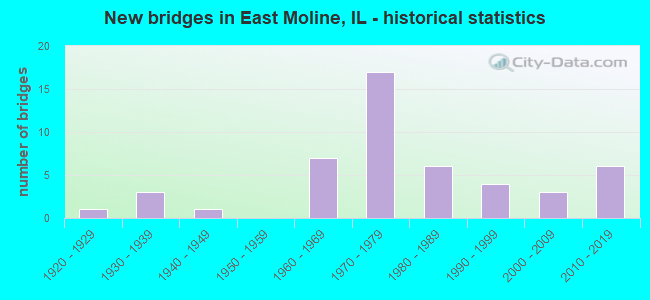
- New bridges - historical statistics
- 11920-1929
- 31930-1939
- 11940-1949
- 71960-1969
- 171970-1979
- 61980-1989
- 41990-1999
- 32000-2009
- 62010-2019
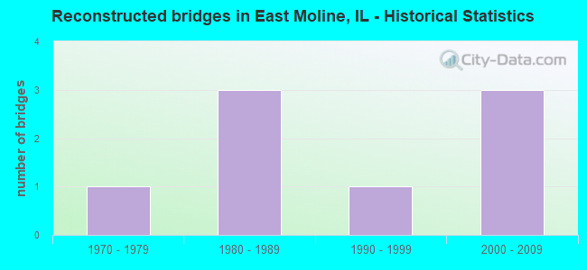
- Reconstructed bridges - Historical Statistics
- 11970-1979
- 31980-1989
- 11990-1999
- 32000-2009

- Bridge Condition - Deck
- 8.0%Very good
- 40.0%Good
- 48.0%Satisfactory
- 4.0%Fair
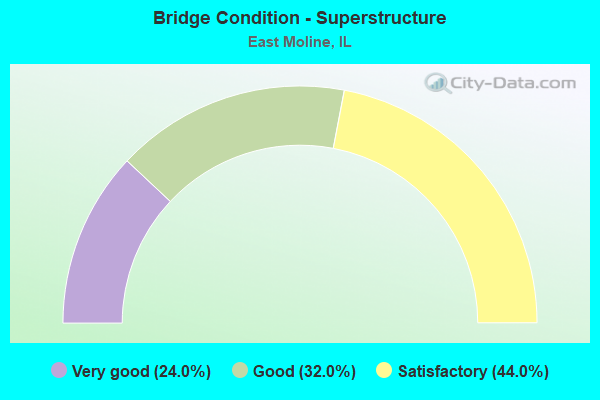
- Bridge Condition - Superstructure
- 24.0%Very good
- 32.0%Good
- 44.0%Satisfactory
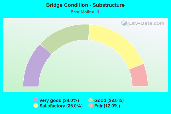
- Bridge Condition - Substructure
- 24.0%Very good
- 28.0%Good
- 36.0%Satisfactory
- 12.0%Fair
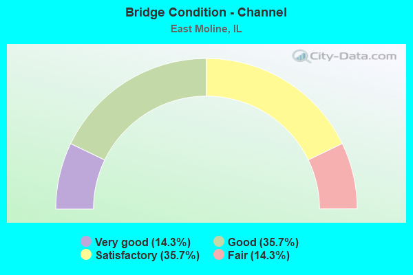
- Bridge Condition - Channel
- 14.3%Very good
- 35.7%Good
- 35.7%Satisfactory
- 14.3%Fair

- Bridge Condition - Culverts
- 14.3%Very good
- 64.3%Good
- 14.3%Satisfactory
- 7.1%Fair
Find on map >> Show street view
Structure Number: 81012, Location: 1.7 MI E FAI 80 (Lat: 41.533819, Lng: -90.310500), Route carried "under" structure: Interstate 88, Year Built: 1976, Structure Length: 0. m, Average Daily Traffic: 18,200 (year 2021), Truck Traffic: 23%, Features Intersected: I-88, Facility Carried by Structure: 226 ST N
Minimum Vertical Clearance: 5.51m (18.08ft), Kilometerpoint: 2.671, Lanes on structure: 2, Lanes under structure: 4, Material/Design: Steel continuous, Design/Construction: Stringer/Multi-beam, Length of Maximum Span: 31.0m (101.7ft)
Find on map >> Show street view
Structure Number: 810121, Location: 2.3 MI SW JCT ILL 92 (Lat: 41.541481, Lng: -90.277011), Route carried "under" structure: Interstate 88, Year Built: 1976, Structure Length: 0. m, Average Daily Traffic: 18,200 (year 2021), Truck Traffic: 23%, Features Intersected: I-88, Facility Carried by Structure: 248 ST N
Minimum Vertical Clearance: 5.38m (17.65ft), Kilometerpoint: 5.600, Lanes on structure: 2, Lanes under structure: 4, Material/Design: Steel continuous, Design/Construction: Stringer/Multi-beam, Length of Maximum Span: 30.7m (100.7ft)
Find on map >> Show street view
Structure Number: 810124, Location: 0.9 MI SW JCT ILL 92 (Lat: 41.547750, Lng: -90.252969), Route carried "under" structure: Interstate 88, Year Built: 1976, Structure Length: 0. m, Average Daily Traffic: 18,200 (year 2021), Truck Traffic: 23%, Features Intersected: I-88, Facility Carried by Structure: 265 ST N CH 4
Minimum Vertical Clearance: 5.31m (17.42ft), Kilometerpoint: 7.789, Lanes on structure: 2, Lanes under structure: 4, Material/Design: Steel continuous, Design/Construction: Stringer/Multi-beam, Length of Maximum Span: 41.8m (137.1ft)
Find on map >> Show street view
Structure Number: 810125, Location: 8.0 MI. E. SILVIS (Lat: 41.556506, Lng: -90.241592), Route carried "under" structure: Interstate 88, Year Built: 1975, Structure Length: 0. m, Average Daily Traffic: 18,200 (year 2021), Truck Traffic: 23%, Features Intersected: I-88, Facility Carried by Structure: FAS 1204 ILL 92
Minimum Vertical Clearance: 5.05m (16.57ft), Kilometerpoint: 9.141, Lanes on structure: 2, Lanes under structure: 4, Material/Design: Steel continuous, Design/Construction: Stringer/Multi-beam, Length of Maximum Span: 42.1m (138.1ft)
Find on map >> Show street view
Structure Number: 810199, Location: 1.3 MI S ILL 5 & 92 (Lat: 41.516825, Lng: -90.341761), Route carried "under" structure: Other road , Year Built: 2014, Structure Length: 0. m, Average Daily Traffic: 375 (year 2020), Truck Traffic: 11%, Features Intersected: BARSTOW ROAD, Facility Carried by Structure: FAI 80 SB
Minimum Vertical Clearance: 5.16m (16.93ft), Kilometerpoint: 5.150, Lanes on structure: 2, Lanes under structure: 2, Material/Design: Steel continuous, Design/Construction: Stringer/Multi-beam, Length of Maximum Span: 24.1m (79.1ft)
Find on map >> Show street view
Structure Number: 8102, Location: 1.3 MI S ILL 5 & 92 (Lat: 41.519894, Lng: -90.307153), Route carried "under" structure: County highway , Year Built: 2016, Structure Length: 0. m, Average Daily Traffic: 250 (year 2020), Truck Traffic: 8%, Features Intersected: BARSTOW ROAD, Facility Carried by Structure: FAI 80 NB
Minimum Vertical Clearance: 5.16m (16.93ft), Kilometerpoint: 3.540, Lanes on structure: 2, Lanes under structure: 2, Material/Design: Steel continuous, Design/Construction: Stringer/Multi-beam, Length of Maximum Span: 24.1m (79.1ft)