Bridge Statistics for Elkhart, Indiana (IN)
Condition, Traffic, Stress, Structural Evaluation, Project Costs
- National Bridge Inventory (NBI) Statistics
- 171Number of bridges
- 1,572ft / 479mTotal length
- $9,028,000Total costs
- 1,771,725Total average daily traffic
- 343,210Total average daily truck traffic
- National Bridge Inventory (NBI) Registered Bridges for Elkhart
- No street view available for this location
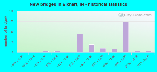
- New bridges - historical statistics
- 11900-1909
- 41920-1929
- 41930-1939
- 451950-1959
- 191960-1969
- 101970-1979
- 81980-1989
- 731990-1999
- 32000-2009
- 42010-2019
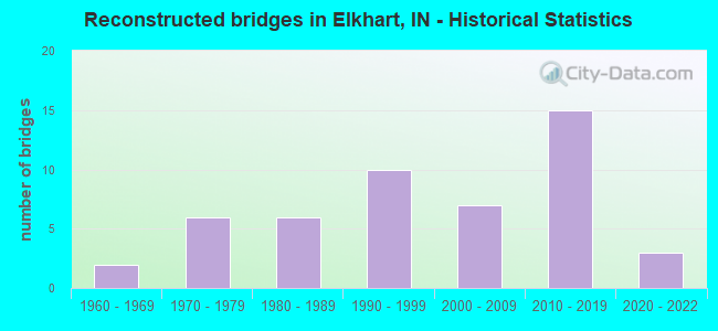
- Reconstructed bridges - Historical Statistics
- 21960-1969
- 61970-1979
- 61980-1989
- 101990-1999
- 72000-2009
- 152010-2019
- 32020-2022
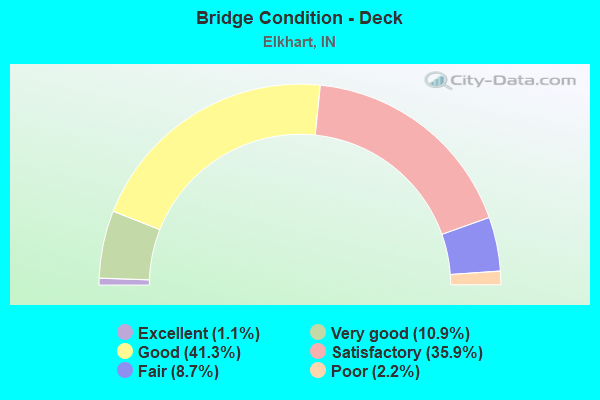
- Bridge Condition - Deck
- 1.1%Excellent
- 10.9%Very good
- 41.3%Good
- 35.9%Satisfactory
- 8.7%Fair
- 2.2%Poor
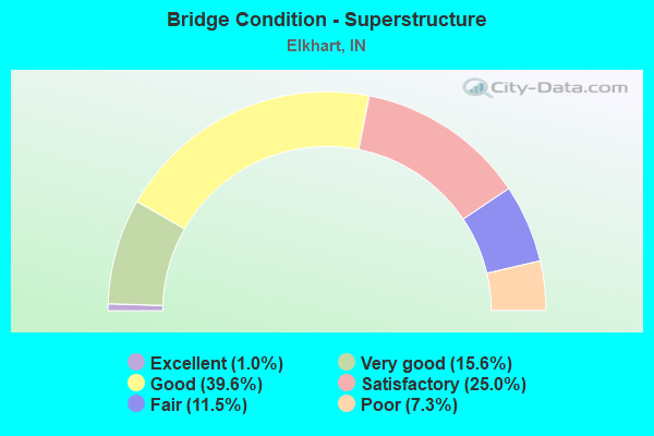
- Bridge Condition - Superstructure
- 1.0%Excellent
- 15.6%Very good
- 39.6%Good
- 25.0%Satisfactory
- 11.5%Fair
- 7.3%Poor
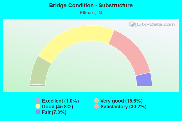
- Bridge Condition - Substructure
- 1.0%Excellent
- 15.6%Very good
- 45.8%Good
- 30.2%Satisfactory
- 7.3%Fair
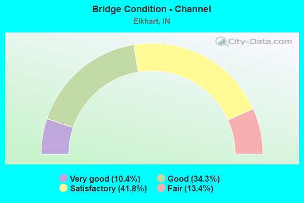
- Bridge Condition - Channel
- 10.4%Very good
- 34.3%Good
- 41.8%Satisfactory
- 13.4%Fair
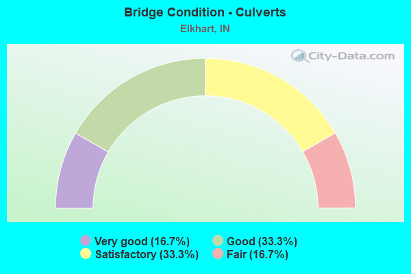
- Bridge Condition - Culverts
- 16.7%Very good
- 33.3%Good
- 33.3%Satisfactory
- 16.7%Fair
Find on map >> Show street view
Structure Number: 2000154, Location: 00.10 N OF WATERFALL DR (Lat: 41.686589, Lng: -85.964019), Route carried "on" structure: City street , Year Built: 1966, Year Reconstructed: 2013, Status: Open, Structure Length: 8.13m (26.67ft), Average Daily Traffic: 14,733 (year 2019), Truck Traffic: 6%, Average Future Daily Traffic: 25,376 (year 2039), Design Load: HL 93, Features Intersected: ELKHART RIVER, Facility Carried by Structure: PRAIRIE ST
Minimum Vertical Clearance: 30+ m (98+ ft), Kilometerpoint: 0.000, Lanes on structure: 4, Owner: County Highway Agency, Approaching Roadway Width: 14.6m (47.9ft), Skew: 4 degrees, Material/Design: Prestressed concrete continuous, Design/Construction: Stringer/Multi-beam, Number Of Spans In Main Unit: 3, Length of Maximum Span: 26.7m (87.6ft), Curb or Sidewalk Widths: Left: 2.0m (6.6ft), Right: 2.0m (6.6ft), Curb-To-Curb Width: 14.6m (47.9ft), Out-to-Out Width: 19.4m (63.6ft)
Condition: Deck: Very good, Superstructure: Very good, Substructure: Satisfactory, Channel: Satisfactory, Operating Rating: 74.1 metric tons, Method Used To Determine Operating Rating: Load and Resistance Factor (LRFR), Inventory Rating: 53.0 metric tons, Method Used To Determine Inventory Rating: Load and Resistance Factor (LRFR), Structural Evaluation: Equal to present minimum criteria, Deck Geometry: High priority of replacement, Waterway Adequacy: Equal to present desirable criteria, Approach Roadway Alignment: Equal to present minimum criteria, Designated Inspection Frequency: Every 24 months, Underwater Inspection Frequency: Every 60 months, Inspection Date: September 2020, Underwater Inspection Date: August 2021, Deck Structure Type: Concrete Cast-file-Place, Wearing Surface/Protective System: Wearing Surface: Monolithic Concrete, Deck Protection: Epoxy Coated Reinforcing
Find on map >> Show street view
Structure Number: 2000155, Location: 00.10 E OF WILLOWDALE (Lat: 41.699319, Lng: -85.981125), Route carried "on" structure: Alternate City street , Year Built: 1977, Year Reconstructed: 2013, Status: Open, Structure Length: 1.99m (6.53ft), Average Daily Traffic: 947 (year 2018), Truck Traffic: 4%, Average Future Daily Traffic: 1,631 (year 2038), Design Load: HL 93, Features Intersected: CHRISTIANA CREEK, Facility Carried by Structure: SIMONTON ST
Minimum Vertical Clearance: 30+ m (98+ ft), Kilometerpoint: 0.000, Lanes on structure: 2, Owner: County Highway Agency, Approaching Roadway Width: 7.9m (25.9ft), Skew: 1 degrees, Material/Design: Prestressed concrete, Design/Construction: Box Beam or Girders - Multiple, Number Of Spans In Main Unit: 1, Length of Maximum Span: 19.1m (62.7ft), Curb or Sidewalk Widths: Left: 1.4m (4.6ft), Right: 1.4m (4.6ft), Curb-To-Curb Width: 7.9m (25.9ft), Out-to-Out Width: 11.6m (38.1ft)
Condition: Deck: Good, Superstructure: Very good, Substructure: Good, Channel: Good, Inventory Rating: 95.2 metric tons, Method Used To Determine Inventory Rating: Load and Resistance Factor (LRFR), Structural Evaluation: Better than present minimum criteria, Deck Geometry: Somewhat better than minimum adequacy, Waterway Adequacy: Equal to present desirable criteria, Approach Roadway Alignment: Equal to present desirable criteria, Designated Inspection Frequency: Every 24 months, Inspection Date: August 2020, Deck Structure Type: Concrete Cast-file-Place, Wearing Surface/Protective System: Wearing Surface: Monolithic Concrete, Deck Protection: Epoxy Coated Reinforcing
Find on map >> Show street view
Structure Number: 2000156, Location: 00.75 E OF S MAIN ST (Lat: 41.673989, Lng: -85.946075), Route carried "on" structure: City street , Year Built: 2001, Status: Open, Structure Length: 6.24m (20.47ft), Average Daily Traffic: 7,912 (year 2018), Truck Traffic: 6%, Average Future Daily Traffic: 13,628 (year 2038), Design Load: HS 20, Features Intersected: ELKHART RIVER, Facility Carried by Structure: INDIANA AVE
Minimum Vertical Clearance: 30+ m (98+ ft), Kilometerpoint: 0.000, Lanes on structure: 2, Owner: County Highway Agency, Approaching Roadway Width: 11.3m (37.1ft), Material/Design: Prestressed concrete continuous, Design/Construction: Stringer/Multi-beam, Number Of Spans In Main Unit: 3, Length of Maximum Span: 21.3m (69.9ft), Curb or Sidewalk Widths: Left: 2.1m (6.9ft), Right: 2.1m (6.9ft), Curb-To-Curb Width: 11.0m (36.1ft), Out-to-Out Width: 15.9m (52.2ft)
Condition: Deck: Very good, Superstructure: Very good, Substructure: Very good, Channel: Good, Inventory Rating: 69.3 metric tons, Method Used To Determine Inventory Rating: Load and Resistance Factor (LRFR), Structural Evaluation: Equal to present desirable criteria, Deck Geometry: Meets minimum limits, Waterway Adequacy: Superior to present desirable criteria, Approach Roadway Alignment: Equal to present desirable criteria, Designated Inspection Frequency: Every 24 months, Inspection Date: September 2020, Deck Structure Type: Concrete Cast-file-Place, Wearing Surface/Protective System: Wearing Surface: Monolithic Concrete, Deck Protection: Epoxy Coated Reinforcing
Find on map >> Show street view
Structure Number: 2000157, Location: 00.30 E OF RICHMOND DR (Lat: 41.681219, Lng: -85.956811), Route carried "on" structure: City street , Year Built: 1931, Year Reconstructed: 1985, Status: Open, Structure Length: 4.88m (16.01ft), Average Daily Traffic: 6,944 (year 2020), Truck Traffic: 2%, Average Future Daily Traffic: 11,960 (year 2040), Features Intersected: ELKHART RIVER, Facility Carried by Structure: MIDDLEBURY ST
Minimum Vertical Clearance: 30+ m (98+ ft), Kilometerpoint: 0.000, Lanes on structure: 2, Owner: County Highway Agency, Approaching Roadway Width: 12.8m (42.0ft), Material/Design: Concrete, Design/Construction: Arch - Deck, Number Of Spans In Main Unit: 3, Length of Maximum Span: 15.2m (49.9ft), Curb or Sidewalk Widths: Left: 2.1m (6.9ft), Right: 2.1m (6.9ft), Curb-To-Curb Width: 12.8m (42.0ft), Out-to-Out Width: 17.5m (57.4ft)
Condition: Superstructure: Satisfactory, Substructure: Fair, Channel: Fair, Operating Rating: 32.7 metric tons, Method Used To Determine Operating Rating: Field evaluation and documented engineering judgment, Inventory Rating: 32.7 metric tons, Method Used To Determine Inventory Rating: Field evaluation and documented engineering judgment, Structural Evaluation: Somewhat better than minimum adequacy, Deck Geometry: Somewhat better than minimum adequacy, Waterway Adequacy: Equal to present desirable criteria, Approach Roadway Alignment: Equal to present desirable criteria, Designated Inspection Frequency: Every 24 months, Inspection Date: September 2020, Wearing Surface/Protective System: Wearing Surface: Bituminous
Find on map >> Show street view
Structure Number: 2000159, Location: 00.00 N OF WATERFALL DR (Lat: 41.685131, Lng: -85.969275), Route carried "on" structure: City street , Year Built: 1928, Year Reconstructed: 1979, Status: Open, Structure Length: 3.69m (12.11ft), Average Daily Traffic: 3,134 (year 2020), Truck Traffic: 3%, Average Future Daily Traffic: 5,398 (year 2040), Design Load: HS 20, Features Intersected: ELKHART RIVER, Facility Carried by Structure: ELKHART AVE
Minimum Vertical Clearance: 30+ m (98+ ft), Kilometerpoint: 0.000, Lanes on structure: 3, Owner: County Highway Agency, Approaching Roadway Width: 13.4m (44.0ft), Skew: 1 degrees, Material/Design: Concrete, Design/Construction: Arch - Deck, Number Of Spans In Main Unit: 1, Length of Maximum Span: 35.7m (117.1ft), Curb or Sidewalk Widths: Left: 1.4m (4.6ft), Right: 1.4m (4.6ft), Curb-To-Curb Width: 13.4m (44.0ft), Out-to-Out Width: 17.7m (58.1ft)
Condition: Deck: Satisfactory, Superstructure: Satisfactory, Substructure: Satisfactory, Channel: Satisfactory, Operating Rating: 32.7 metric tons, Method Used To Determine Operating Rating: Field evaluation and documented engineering judgment, Inventory Rating: 32.7 metric tons, Method Used To Determine Inventory Rating: Field evaluation and documented engineering judgment, Structural Evaluation: Equal to present minimum criteria, Deck Geometry: Somewhat better than minimum adequacy, Waterway Adequacy: Equal to present desirable criteria, Approach Roadway Alignment: Equal to present desirable criteria, Designated Inspection Frequency: Every 24 months, Inspection Date: August 2020, Deck Structure Type: Concrete Cast-file-Place, Wearing Surface/Protective System: Wearing Surface: Monolithic Concrete
Find on map >> Show street view
Structure Number: 200016, Location: 01.00 S OF HIVELY (Lat: 41.648639, Lng: -85.933761), Route carried "on" structure: City street 319, Year Built: 1936, Year Reconstructed: 1976, Status: Open, Structure Length: 1.72m (5.64ft), Average Daily Traffic: 3,198 (year 2018), Truck Traffic: 6%, Average Future Daily Traffic: 5,508 (year 2038), Features Intersected: YELLOW CREEK, Facility Carried by Structure: CR 45
Minimum Vertical Clearance: 30+ m (98+ ft), Kilometerpoint: 0.000, Lanes on structure: 2, Owner: County Highway Agency, Approaching Roadway Width: 6.7m (22.0ft), Material/Design: Prestressed concrete, Design/Construction: Box Beam or Girders - Multiple, Number Of Spans In Main Unit: 1, Length of Maximum Span: 15.8m (51.8ft), Curb-To-Curb Width: 8.5m (27.9ft), Out-to-Out Width: 8.5m (27.9ft)
Condition: Deck: Satisfactory, Superstructure: Fair, Substructure: Good, Channel: Satisfactory, Operating Rating: 44.4 metric tons, Method Used To Determine Operating Rating: Load and Resistance Factor (LRFR), Inventory Rating: 31.0 metric tons, Method Used To Determine Inventory Rating: Load and Resistance Factor (LRFR), Structural Evaluation: Somewhat better than minimum adequacy, Deck Geometry: Meets minimum limits, Waterway Adequacy: Equal to present desirable criteria, Approach Roadway Alignment: Equal to present desirable criteria, Designated Inspection Frequency: Every 24 months, Inspection Date: August 2020, Deck Structure Type: Concrete Cast-file-Place, Wearing Surface/Protective System: Wearing Surface: Monolithic Concrete
Find on map >> Show street view
Structure Number: 2000162, Location: 00.10 W OF JOHNSON ST (Lat: 41.693261, Lng: -85.968133), Route carried "on" structure: City street , Year Built: 1963, Year Reconstructed: 1979, Status: Open, Structure Length: 1.13m (3.71ft), Average Daily Traffic: 12,899 (year 2019), Truck Traffic: 4%, Average Future Daily Traffic: 22,217 (year 2039), Design Load: H 20, Features Intersected: CHRISTIANA CREEK, Facility Carried by Structure: BEARDSLEY AVE
Minimum Vertical Clearance: 30+ m (98+ ft), Kilometerpoint: 0.000, Lanes on structure: 2, Owner: County Highway Agency, Approaching Roadway Width: 11.6m (38.1ft), Skew: 4 degrees, Material/Design: Concrete, Design/Construction: Channel Beam, Number Of Spans In Main Unit: 1, Length of Maximum Span: 10.1m (33.1ft), Curb or Sidewalk Widths: Left: 1.5m (4.9ft), Right: 1.5m (4.9ft), Curb-To-Curb Width: 12.8m (42.0ft), Out-to-Out Width: 16.3m (53.5ft)
Condition: Deck: Fair, Superstructure: Fair, Substructure: Fair, Channel: Fair, Operating Rating: 32.7 metric tons, Method Used To Determine Operating Rating: Field evaluation and documented engineering judgment, Inventory Rating: 32.7 metric tons, Method Used To Determine Inventory Rating: Field evaluation and documented engineering judgment, Structural Evaluation: Somewhat better than minimum adequacy, Deck Geometry: Somewhat better than minimum adequacy, Waterway Adequacy: Equal to present desirable criteria, Approach Roadway Alignment: Equal to present desirable criteria, Designated Inspection Frequency: Every 24 months, Inspection Date: September 2020, Deck Structure Type: Concrete Precast Panels, Wearing Surface/Protective System: Wearing Surface: Bituminous
Find on map >> Show street view
Structure Number: 2000164, Location: 00.80 E OF US 33 (Lat: 41.659461, Lng: -85.932425), Route carried "on" structure: City street , Year Built: 1958, Status: Posted for load, Structure Length: 1.37m (4.49ft), Average Daily Traffic: 4,608 (year 2018), Truck Traffic: 12%, Average Future Daily Traffic: 7,937 (year 2038), Design Load: H 20, Features Intersected: YELLOW CREEK, Facility Carried by Structure: HIVELY AVE
Minimum Vertical Clearance: 30+ m (98+ ft), Kilometerpoint: 0.000, Lanes on structure: 2, Owner: County Highway Agency, Approaching Roadway Width: 8.2m (26.9ft), Material/Design: Prestressed concrete, Design/Construction: Box Beam or Girders - Multiple, Number Of Spans In Main Unit: 1, Length of Maximum Span: 12.6m (41.3ft), Curb-To-Curb Width: 10.7m (35.1ft), Out-to-Out Width: 10.8m (35.4ft)
Condition: Deck: Satisfactory, Superstructure: Fair, Substructure: Satisfactory, Channel: Fair, Operating Rating: 55.6 metric tons, Method Used To Determine Operating Rating: Load and Resistance Factor (LRFR), Inventory Rating: 40.6 metric tons, Method Used To Determine Inventory Rating: Load and Resistance Factor (LRFR), Structural Evaluation: Somewhat better than minimum adequacy, Deck Geometry: Somewhat better than minimum adequacy, Waterway Adequacy: Equal to present desirable criteria, Approach Roadway Alignment: Equal to present desirable criteria, Length Of Structure Improvement: 2.04m (6.69ft), Designated Inspection Frequency: Every 24 months, Inspection Date: August 2020, Bridge Improvement Cost: $373,000, Roadway Improvement Cost: $190,000, Total Project Cost: $711,000 ( Estimate for 2020), Deck Structure Type: Concrete Cast-file-Place, Wearing Surface/Protective System: Wearing Surface: Monolithic Concrete, Deck Protection: Epoxy Coated Reinforcing
Find on map >> Show street view
Structure Number: 2000165, Location: 00.10 W OF FRANKLIN ST (Lat: 41.677019, Lng: -85.990800), Route carried "on" structure: City street , Year Built: 1939, Year Reconstructed: 2010, Status: Open, Structure Length: 8.23m (27.00ft), Average Daily Traffic: 5,562 (year 2019), Truck Traffic: 3%, Average Future Daily Traffic: 9,580 (year 2039), Design Load: HS 20, Features Intersected: ST JOSEPH RIVER, Facility Carried by Structure: BRIDGE ST
Minimum Vertical Clearance: 30+ m (98+ ft), Kilometerpoint: 0.000, Lanes on structure: 3, Owner: County Highway Agency, Approaching Roadway Width: 12.1m (39.7ft), Material/Design: Concrete continuous, Design/Construction: Stringer/Multi-beam, Number Of Spans In Main Unit: 3, Length of Maximum Span: 35.7m (117.1ft), Curb or Sidewalk Widths: Left: 2.0m (6.6ft), Right: 2.0m (6.6ft), Curb-To-Curb Width: 12.1m (39.7ft), Out-to-Out Width: 16.6m (54.5ft)
Condition: Deck: Good, Superstructure: Satisfactory, Substructure: Satisfactory, Channel: Good, Operating Rating: 32.7 metric tons, Method Used To Determine Operating Rating: Field evaluation and documented engineering judgment, Inventory Rating: 32.7 metric tons, Method Used To Determine Inventory Rating: Field evaluation and documented engineering judgment, Structural Evaluation: Equal to present minimum criteria, Deck Geometry: Meets minimum limits, Waterway Adequacy: Equal to present desirable criteria, Approach Roadway Alignment: Equal to present minimum criteria, Designated Inspection Frequency: Every 24 months, Underwater Inspection Frequency: Every 60 months, Inspection Date: September 2020, Underwater Inspection Date: August 2021, Deck Structure Type: Concrete Cast-file-Place, Wearing Surface/Protective System: Wearing Surface: Monolithic Concrete
Find on map >> Show street view
Structure Number: 2000166, Location: 00.10 S OF GREENLEAF BLVD (Lat: 41.697589, Lng: -85.916069), Route carried "on" structure: Alternate City street , Year Built: 1950, Status: Open, Structure Length: 0.79m (2.59ft), Average Daily Traffic: 118 (year 2018), Truck Traffic: 24%, Average Future Daily Traffic: 203 (year 2038), Features Intersected: SHORELANE CANAL, Facility Carried by Structure: SHORELANE W ST
Minimum Vertical Clearance: 30+ m (98+ ft), Kilometerpoint: 0.000, Lanes on structure: 2, Owner: County Highway Agency, Approaching Roadway Width: 4.9m (16.1ft), Material/Design: Steel, Design/Construction: Stringer/Multi-beam, Number Of Spans In Main Unit: 1, Length of Maximum Span: 7.0m (23.0ft), Curb or Sidewalk Widths: Left: 0.4m (1.3ft), Right: 0.4m (1.3ft), Curb-To-Curb Width: 6.6m (21.7ft), Out-to-Out Width: 7.2m (23.6ft)
Condition: Deck: Satisfactory, Superstructure: Satisfactory, Substructure: Satisfactory, Channel: Good, Operating Rating: 62.2 metric tons, Method Used To Determine Operating Rating: Load and Resistance Factor (LRFR), Inventory Rating: 54.6 metric tons, Method Used To Determine Inventory Rating: Load and Resistance Factor (LRFR), Structural Evaluation: Equal to present minimum criteria, Deck Geometry: Meets minimum limits, Waterway Adequacy: Equal to present minimum criteria, Approach Roadway Alignment: Equal to present desirable criteria, Designated Inspection Frequency: Every 24 months, Inspection Date: September 2020, Deck Structure Type: Concrete Cast-file-Place, Wearing Surface/Protective System: Wearing Surface: Bituminous
Find on map >> Show street view
Structure Number: 2000177, Location: 00.50 S OF CR 4 (Lat: 41.730981, Lng: -85.927544), Route carried "on" structure: Alternate City street 125, Year Built: 1958, Status: Open, Structure Length: 1.10m (3.61ft), Average Daily Traffic: 2,837 (year 2019), Truck Traffic: 5%, Average Future Daily Traffic: 4,886 (year 2039), Features Intersected: PUTERBAUGH CREEK, Facility Carried by Structure: CR 13
Minimum Vertical Clearance: 30+ m (98+ ft), Kilometerpoint: 0.000, Lanes on structure: 2, Owner: County Highway Agency, Approaching Roadway Width: 9.1m (29.9ft), Skew: 3 degrees, Material/Design: Concrete, Design/Construction: Culvert, Number Of Spans In Main Unit: 2, Length of Maximum Span: 5.2m (17.1ft), Curb-To-Curb Width: 9.1m (29.9ft), Out-to-Out Width: 9.1m (29.9ft)
Condition: Channel: Satisfactory, Culverts: Good, Operating Rating: 32.7 metric tons, Method Used To Determine Operating Rating: Field evaluation and documented engineering judgment, Inventory Rating: 32.7 metric tons, Method Used To Determine Inventory Rating: Field evaluation and documented engineering judgment, Structural Evaluation: Better than present minimum criteria, Deck Geometry: Meets minimum limits, Waterway Adequacy: Better than present minimum criteria, Approach Roadway Alignment: Equal to present desirable criteria, Designated Inspection Frequency: Every 24 months, Inspection Date: September 2020
Find on map >> Show street view
Structure Number: 2000182, Location: 00.10 S OF CR 26 (Lat: 41.622461, Lng: -86.021958), Route carried "on" structure: County highway 113, Year Built: 1955, Status: Open, Structure Length: 0.67m (2.20ft), Average Daily Traffic: 674 (year 2019), Truck Traffic: 10%, Average Future Daily Traffic: 1,161 (year 2039), Features Intersected: BRANCH OF BAUGO CREEK, Facility Carried by Structure: CR 3
Minimum Vertical Clearance: 30+ m (98+ ft), Kilometerpoint: 0.000, Lanes on structure: 2, Owner: County Highway Agency, Approaching Roadway Width: 6.4m (21.0ft), Material/Design: Concrete, Design/Construction: Culvert, Number Of Spans In Main Unit: 1, Length of Maximum Span: 6.1m (20.0ft), Curb-To-Curb Width: 6.4m (21.0ft), Out-to-Out Width: 6.4m (21.0ft)
Condition: Channel: Satisfactory, Culverts: Satisfactory, Operating Rating: 32.7 metric tons, Method Used To Determine Operating Rating: Field evaluation and documented engineering judgment, Inventory Rating: 32.7 metric tons, Method Used To Determine Inventory Rating: Field evaluation and documented engineering judgment, Structural Evaluation: Equal to present minimum criteria, Deck Geometry: High priority of corrective action, Waterway Adequacy: Better than present minimum criteria, Approach Roadway Alignment: Equal to present minimum criteria, Designated Inspection Frequency: Every 24 months, Inspection Date: August 2020
Find on map >> Show street view
Structure Number: 2000193, Location: 00.10 E OF CR 1 (Lat: 41.635650, Lng: -86.040650), Route carried "on" structure: Alternate City street 184, Year Built: 1978, Status: Open, Structure Length: 0.64m (2.10ft), Average Daily Traffic: 1,137 (year 2019), Truck Traffic: 8%, Average Future Daily Traffic: 1,958 (year 2039), Features Intersected: BRANCH OF BAUGO CREEK, Facility Carried by Structure: CR 24
Minimum Vertical Clearance: 30+ m (98+ ft), Kilometerpoint: 0.000, Lanes on structure: 2, Owner: County Highway Agency, Approaching Roadway Width: 6.7m (22.0ft), Skew: 3 degrees, Material/Design: Steel, Design/Construction: Culvert, Number Of Spans In Main Unit: 2, Length of Maximum Span: 2.7m (8.9ft), Curb-To-Curb Width: 6.7m (22.0ft), Out-to-Out Width: 6.7m (22.0ft)
Condition: Channel: Fair, Culverts: Satisfactory, Operating Rating: 75.0 metric tons, Method Used To Determine Operating Rating: Load and Resistance Factor (LRFR), Inventory Rating: 59.8 metric tons, Method Used To Determine Inventory Rating: Load and Resistance Factor (LRFR), Structural Evaluation: Equal to present minimum criteria, Deck Geometry: High priority of corrective action, Waterway Adequacy: Equal to present minimum criteria, Approach Roadway Alignment: Equal to present minimum criteria, Designated Inspection Frequency: Every 24 months, Inspection Date: August 2020
Find on map >> Show street view
Structure Number: 2000195, Location: 00.00 S OF BEARDSLEY AVE. (Lat: 41.693169, Lng: -85.966064), Route carried "on" structure: City street , Year Built: 1994, Year Reconstructed: 2010, Status: Open, Structure Length: 11.83m (38.81ft), Average Daily Traffic: 21,080 (year 2020), Truck Traffic: 15%, Average Future Daily Traffic: 36,290 (year 2040), Design Load: HS 20, Features Intersected: ST JOSEPH RIVER, Facility Carried by Structure: JOHNSON STREET NB
Minimum Vertical Clearance: 30+ m (98+ ft), Kilometerpoint: 0.000, Lanes on structure: 4, Owner: County Highway Agency, Approaching Roadway Width: 13.1m (43.0ft), Skew: 20 degrees, Material/Design: Prestressed concrete continuous, Design/Construction: Stringer/Multi-beam, Number Of Spans In Main Unit: 4, Length of Maximum Span: 29.9m (98.1ft), Curb or Sidewalk Widths: Left: 0.3m (1.0ft), Right: 1.7m (5.6ft), Curb-To-Curb Width: 13.3m (43.6ft), Out-to-Out Width: 15.6m (51.2ft)
Condition: Deck: Good, Superstructure: Very good, Substructure: Satisfactory, Channel: Good, Operating Rating: 52.2 metric tons, Method Used To Determine Operating Rating: Load and Resistance Factor (LRFR), Inventory Rating: 46.1 metric tons, Method Used To Determine Inventory Rating: Load and Resistance Factor (LRFR), Structural Evaluation: Equal to present minimum criteria, Deck Geometry: High priority of replacement, Waterway Adequacy: Superior to present desirable criteria, Approach Roadway Alignment: Equal to present desirable criteria, Designated Inspection Frequency: Every 24 months, Underwater Inspection Frequency: Every 60 months, Inspection Date: September 2020, Underwater Inspection Date: August 2021, Deck Structure Type: Concrete Cast-file-Place, Wearing Surface/Protective System: Wearing Surface: Monolithic Concrete, Deck Protection: Epoxy Coated Reinforcing
Find on map >> Show street view
Structure Number: 2000196, Location: 00.65 E SR 219 (Lat: 41.688689, Lng: -86.048842), Route carried "on" structure: City street , Year Built: 1985, Status: Open, Structure Length: 2.26m (7.41ft), Average Daily Traffic: 11,168 (year 2018), Truck Traffic: 4%, Average Future Daily Traffic: 19,236 (year 2038), Design Load: HS 20, Features Intersected: COBUS CREEK, Facility Carried by Structure: OLD US 20
Minimum Vertical Clearance: 30+ m (98+ ft), Kilometerpoint: 0.000, Lanes on structure: 2, Owner: County Highway Agency, Approaching Roadway Width: 13.4m (44.0ft), Material/Design: Concrete continuous, Design/Construction: Slab, Number Of Spans In Main Unit: 3, Length of Maximum Span: 8.9m (29.2ft), Curb-To-Curb Width: 13.4m (44.0ft), Out-to-Out Width: 14.2m (46.6ft)
Condition: Deck: Satisfactory, Superstructure: Satisfactory, Substructure: Satisfactory, Channel: Satisfactory, Operating Rating: 49.9 metric tons, Method Used To Determine Operating Rating: Load Factor (LF), Inventory Rating: 30.6 metric tons, Method Used To Determine Inventory Rating: Load Factor (LF), Structural Evaluation: Equal to present minimum criteria, Deck Geometry: Equal to present minimum criteria, Waterway Adequacy: Equal to present desirable criteria, Approach Roadway Alignment: Equal to present minimum criteria, Designated Inspection Frequency: Every 24 months, Inspection Date: September 2020, Deck Structure Type: Concrete Cast-file-Place, Wearing Surface/Protective System: Wearing Surface: Bituminous, Deck Protection: Epoxy Coated Reinforcing
Find on map >> Show street view
Structure Number: 2000197, Location: 01.20 E SR 19 (Lat: 41.684061, Lng: -85.981078), Route carried "on" structure: City street , Year Built: 1926, Year Reconstructed: 2002, Status: Open, Structure Length: 7.69m (25.23ft), Average Daily Traffic: 6,731 (year 2019), Truck Traffic: 6%, Average Future Daily Traffic: 11,594 (year 2039), Design Load: HS 20, Features Intersected: ST JOSEPH RIVER, Facility Carried by Structure: LEXINGTON AVENUE
Minimum Vertical Clearance: 30+ m (98+ ft), Kilometerpoint: 0.000, Lanes on structure: 3, Owner: County Highway Agency, Approaching Roadway Width: 10.1m (33.1ft), Material/Design: Concrete, Design/Construction: Arch - Deck, Number Of Spans In Main Unit: 3, Length of Maximum Span: 26.2m (86.0ft), Curb or Sidewalk Widths: Left: 3.1m (10.2ft), Right: 3.3m (10.8ft), Curb-To-Curb Width: 11.8m (38.7ft), Out-to-Out Width: 19.6m (64.3ft)
Condition: Superstructure: Good, Substructure: Satisfactory, Channel: Good, Operating Rating: 32.7 metric tons, Method Used To Determine Operating Rating: Field evaluation and documented engineering judgment, Inventory Rating: 32.7 metric tons, Method Used To Determine Inventory Rating: Field evaluation and documented engineering judgment, Structural Evaluation: Equal to present minimum criteria, Deck Geometry: High priority of corrective action, Waterway Adequacy: Superior to present desirable criteria, Approach Roadway Alignment: Equal to present minimum criteria, Designated Inspection Frequency: Every 24 months, Underwater Inspection Frequency: Every 60 months, Inspection Date: September 2020, Underwater Inspection Date: August 2021, Wearing Surface/Protective System: Wearing Surface: Monolithic Concrete
Find on map >> Show street view
Structure Number: 2000198, Location: 00.10 E OF N MAIN ST (Lat: 41.687800, Lng: -85.972014), Route carried "on" structure: City street , Year Built: 1986, Year Reconstructed: 2021, Status: Open, Structure Length: 5.89m (19.32ft), Average Daily Traffic: 10,533 (year 2020), Truck Traffic: 11%, Average Future Daily Traffic: 18,142 (year 2040), Design Load: HS 20, Features Intersected: ELKHART RIVER, Facility Carried by Structure: JACKSON ST
Minimum Vertical Clearance: 30+ m (98+ ft), Kilometerpoint: 0.000, Lanes on structure: 2, Owner: County Highway Agency, Approaching Roadway Width: 10.0m (32.8ft), Skew: 21 degrees, Material/Design: Prestressed concrete continuous, Design/Construction: Box Beam or Girders - Single/Spread, Number Of Spans In Main Unit: 3, Length of Maximum Span: 20.0m (65.6ft), Curb or Sidewalk Widths: Left: 4.1m (13.5ft), Right: 4.1m (13.5ft), Curb-To-Curb Width: 10.7m (35.1ft), Out-to-Out Width: 20.3m (66.6ft)
Condition: Deck: Good, Superstructure: Good, Substructure: Good, Channel: Good, Operating Rating: 54.1 metric tons, Method Used To Determine Operating Rating: Load and Resistance Factor Rating (LRFR) rating reported by rating factor(RF) method using HL-93 loadings, Inventory Rating: 34.3 metric tons, Method Used To Determine Inventory Rating: Load and Resistance Factor Rating (LRFR) rating reported by rating factor(RF) method using HL-93 loadings, Structural Evaluation: Better than present minimum criteria, Deck Geometry: Meets minimum limits, Waterway Adequacy: Superior to present desirable criteria, Approach Roadway Alignment: Equal to present desirable criteria, Designated Inspection Frequency: Every 24 months, Inspection Date: September 2021, Deck Structure Type: Concrete Cast-file-Place, Wearing Surface/Protective System: Wearing Surface: Monolithic Concrete, Deck Protection: Epoxy Coated Reinforcing
Find on map >> Show street view
Structure Number: 2000199, Location: 00.10 W OF US 33 (Lat: 41.641711, Lng: -85.929253), Route carried "on" structure: Alternate City street , Year Built: 1972, Year Reconstructed: 1996, Status: Open, Structure Length: 2.50m (8.20ft), Average Daily Traffic: 4,106 (year 2018), Truck Traffic: 5%, Average Future Daily Traffic: 7,072 (year 2038), Features Intersected: YELLOW CREEK, Facility Carried by Structure: CONCORD MALL DR
Minimum Vertical Clearance: 30+ m (98+ ft), Kilometerpoint: 0.000, Lanes on structure: 4, Owner: County Highway Agency, Approaching Roadway Width: 16.2m (53.1ft), Skew: 25 degrees, Material/Design: Prestressed concrete, Design/Construction: Box Beam or Girders - Multiple, Number Of Spans In Main Unit: 2, Length of Maximum Span: 12.0m (39.4ft), Curb-To-Curb Width: 16.0m (52.5ft), Out-to-Out Width: 17.1m (56.1ft)
Condition: Deck: Satisfactory, Superstructure: Satisfactory, Substructure: Satisfactory, Channel: Satisfactory, Operating Rating: 84.7 metric tons, Method Used To Determine Operating Rating: Load and Resistance Factor (LRFR), Inventory Rating: 68.4 metric tons, Method Used To Determine Inventory Rating: Load and Resistance Factor (LRFR), Structural Evaluation: Equal to present minimum criteria, Deck Geometry: Meets minimum limits, Waterway Adequacy: Equal to present desirable criteria, Approach Roadway Alignment: Equal to present desirable criteria, Designated Inspection Frequency: Every 24 months, Inspection Date: August 2020, Deck Structure Type: Concrete Precast Panels, Wearing Surface/Protective System: Wearing Surface: Bituminous
Find on map >> Show street view
Structure Number: 20002, Location: 00.10 S OF OLD US 20 (Lat: 41.683719, Lng: -86.010864), Route carried "on" structure: Alternate City street , Year Built: 1987, Status: Open, Structure Length: 1.80m (5.91ft), Average Daily Traffic: 82 (year 2020), Truck Traffic: 13%, Average Future Daily Traffic: 141 (year 2040), Features Intersected: ST JOSEPH RIVER, Facility Carried by Structure: QUAIL ISLAND DR
Minimum Vertical Clearance: 30+ m (98+ ft), Kilometerpoint: 0.000, Lanes on structure: 2, Owner: County Highway Agency, Approaching Roadway Width: 7.3m (24.0ft), Material/Design: Wood or Timber, Design/Construction: Slab, Number Of Spans In Main Unit: 3, Length of Maximum Span: 7.6m (24.9ft), Curb or Sidewalk Widths: Left: 1.7m (5.6ft), Right: 1.7m (5.6ft), Curb-To-Curb Width: 7.3m (24.0ft), Out-to-Out Width: 10.8m (35.4ft)
Condition: Deck: Satisfactory, Superstructure: Satisfactory, Substructure: Satisfactory, Channel: Satisfactory, Operating Rating: 58.3 metric tons, Method Used To Determine Operating Rating: Load and Resistance Factor (LRFR), Inventory Rating: 44.4 metric tons, Method Used To Determine Inventory Rating: Load and Resistance Factor (LRFR), Structural Evaluation: Equal to present minimum criteria, Deck Geometry: Equal to present minimum criteria, Waterway Adequacy: Equal to present desirable criteria, Approach Roadway Alignment: Equal to present minimum criteria, Designated Inspection Frequency: Every 24 months, Inspection Date: September 2020, Deck Structure Type: Wood or Timber, Wearing Surface/Protective System: Wearing Surface: Bituminous
Find on map >> Show street view
Structure Number: 2000202, Location: 00.70 N SR 120 (Lat: 41.692200, Lng: -85.975961), Route carried "on" structure: City street , Year Built: 1927, Year Reconstructed: 1986, Status: Open, Structure Length: 9.08m (29.79ft), Average Daily Traffic: 14,437 (year 2019), Truck Traffic: 6%, Average Future Daily Traffic: 24,866 (year 2039), Features Intersected: ST JOSEPH RIVER, Facility Carried by Structure: N MAIN STREET
Minimum Vertical Clearance: 30+ m (98+ ft), Kilometerpoint: 0.000, Lanes on structure: 5, Owner: County Highway Agency, Approaching Roadway Width: 18.3m (60.0ft), Skew: 2 degrees, Material/Design: Concrete, Design/Construction: Arch - Deck, Number Of Spans In Main Unit: 3, Length of Maximum Span: 28.0m (91.9ft), Curb or Sidewalk Widths: Left: 2.3m (7.5ft), Right: 2.3m (7.5ft), Curb-To-Curb Width: 18.3m (60.0ft), Out-to-Out Width: 23.9m (78.4ft)
Condition: Superstructure: Satisfactory, Substructure: Fair, Channel: Good, Operating Rating: 32.7 metric tons, Method Used To Determine Operating Rating: Field evaluation and documented engineering judgment, Inventory Rating: 32.7 metric tons, Method Used To Determine Inventory Rating: Field evaluation and documented engineering judgment, Structural Evaluation: Somewhat better than minimum adequacy, Deck Geometry: High priority of replacement, Waterway Adequacy: Superior to present desirable criteria, Approach Roadway Alignment: Equal to present desirable criteria, Designated Inspection Frequency: Every 24 months, Underwater Inspection Frequency: Every 60 months, Inspection Date: September 2020, Underwater Inspection Date: August 2021, Wearing Surface/Protective System: Wearing Surface: Bituminous
Find on map >> Show street view
Structure Number: 200021, Location: 00.30 N SR 120 (Lat: 41.706711, Lng: -85.888503), Route carried "on" structure: City street 17, Year Built: 2011, Status: Open, Structure Length: 14.63m (48.00ft), Average Daily Traffic: 30,480 (year 2019), Truck Traffic: 8%, Average Future Daily Traffic: 52,499 (year 2039), Design Load: HS 25 or greater, Features Intersected: ST JOSEPH RIVER
Minimum Vertical Clearance: 30+ m (98+ ft), Kilometerpoint: 0.000, Lanes on structure: 7, Owner: County Highway Agency, Approaching Roadway Width: 22.6m (74.1ft), Material/Design: Concrete, Design/Construction: Arch - Deck, Number Of Spans In Main Unit: 5, Length of Maximum Span: 27.4m (89.9ft), Curb or Sidewalk Widths: Left: 2.7m (8.9ft), Right: 2.7m (8.9ft), Curb-To-Curb Width: 26.6m (87.3ft), Out-to-Out Width: 32.8m (107.6ft)
Condition: Superstructure: Good, Substructure: Satisfactory, Channel: Good, Operating Rating: 32.7 metric tons, Method Used To Determine Operating Rating: Field evaluation and documented engineering judgment, Inventory Rating: 32.7 metric tons, Method Used To Determine Inventory Rating: Field evaluation and documented engineering judgment, Structural Evaluation: Equal to present minimum criteria, Deck Geometry: Meets minimum limits, Waterway Adequacy: Equal to present desirable criteria, Approach Roadway Alignment: Equal to present desirable criteria, Designated Inspection Frequency: Every 24 months, Underwater Inspection Frequency: Every 60 months, Inspection Date: September 2020, Underwater Inspection Date: August 2021, Wearing Surface/Protective System: Wearing Surface: Bituminous
Find on map >> Show street view
Structure Number: 2000213, Location: 00.00 S BEARDSLEY AVE. (Lat: 41.693114, Lng: -85.966117), Route carried "on" structure: City street , Year Built: 2010, Status: Open, Structure Length: 11.83m (38.81ft), Average Daily Traffic: 21,080 (year 2020), Truck Traffic: 15%, Average Future Daily Traffic: 36,290 (year 2040), Design Load: HS 25 or greater, Features Intersected: ST JOSEPH RIVER, Facility Carried by Structure: JOHNSON STREET SB
Minimum Vertical Clearance: 30+ m (98+ ft), Kilometerpoint: 0.000, Lanes on structure: 3, Owner: County Highway Agency, Approaching Roadway Width: 11.3m (37.1ft), Skew: 20 degrees, Material/Design: Steel continuous, Design/Construction: Stringer/Multi-beam, Number Of Spans In Main Unit: 2, Length of Maximum Span: 60.9m (199.8ft), Curb or Sidewalk Widths: Left: 0.6m (2.0ft), Right: 1.8m (5.9ft), Curb-To-Curb Width: 11.3m (37.1ft), Out-to-Out Width: 14.1m (46.3ft)
Condition: Deck: Good, Superstructure: Very good, Substructure: Good, Channel: Very good, Operating Rating: 90.4 metric tons, Method Used To Determine Operating Rating: Load and Resistance Factor (LRFR), Inventory Rating: 76.7 metric tons, Method Used To Determine Inventory Rating: Load and Resistance Factor (LRFR), Structural Evaluation: Better than present minimum criteria, Deck Geometry: High priority of replacement, Waterway Adequacy: Superior to present desirable criteria, Approach Roadway Alignment: Equal to present desirable criteria, Designated Inspection Frequency: Every 24 months, Underwater Inspection Frequency: Every 60 months, Inspection Date: September 2020, Underwater Inspection Date: August 2021, Deck Structure Type: Concrete Cast-file-Place, Wearing Surface/Protective System: Wearing Surface: Monolithic Concrete, Deck Protection: Epoxy Coated Reinforcing
Find on map >> Show street view
Structure Number: 2000215, Location: 00.42 N INDIANA AVE (Lat: 41.679881, Lng: -85.965561), Route carried "on" structure: City street , Year Built: 2015, Status: Open, Structure Length: 4.42m (14.50ft), Average Daily Traffic: 13,435 (year 2018), Truck Traffic: 6%, Average Future Daily Traffic: 23,141 (year 2038), Design Load: HL 93, Features Intersected: NORFOLK SOUTHERN RR, Facility Carried by Structure: PRAIRIE ST
Minimum Vertical Clearance: 30+ m (98+ ft), Kilometerpoint: 0.000, Lanes on structure: 2, Owner: County Highway Agency, Maintenance Responsibility: City or Municipal Highway Agency, Approaching Roadway Width: 14.6m (47.9ft), Skew: 4 degrees, Material/Design: Steel, Design/Construction: Stringer/Multi-beam, Number Of Spans In Main Unit: 1, Length of Maximum Span: 43.6m (143.0ft), Curb-To-Curb Width: 18.3m (60.0ft), Out-to-Out Width: 19.0m (62.3ft)
Condition: Deck: Very good, Superstructure: Very good, Substructure: Very good, Operating Rating: 62.3 metric tons, Method Used To Determine Operating Rating: Load and Resistance Factor (LRFR), Inventory Rating: 57.8 metric tons, Method Used To Determine Inventory Rating: Load and Resistance Factor (LRFR), Structural Evaluation: Equal to present desirable criteria, Deck Geometry: Superior to present desirable criteria, Underclear: Superior to present desirable criteria, Approach Roadway Alignment: Equal to present minimum criteria, Designated Inspection Frequency: Every 24 months, Inspection Date: September 2020, Deck Structure Type: Concrete Cast-file-Place, Wearing Surface/Protective System: Wearing Surface: Monolithic Concrete, Deck Protection: Epoxy Coated Reinforcing
Find on map >> Show street view
Structure Number: 2000216, Location: 00.10 E CR 7 (Lat: 41.738858, Lng: -85.986836), Route carried "on" structure: Alternate City street 84, Year Built: 2015, Status: Open, Structure Length: 2.87m (9.42ft), Average Daily Traffic: 9,089 (year 2019), Truck Traffic: 9%, Average Future Daily Traffic: 15,655 (year 2039), Design Load: HL 93, Features Intersected: CHRISTIANA CREEK, Facility Carried by Structure: CR 4
Minimum Vertical Clearance: 30+ m (98+ ft), Kilometerpoint: 0.000, Lanes on structure: 2, Owner: County Highway Agency, Approaching Roadway Width: 7.3m (24.0ft), Material/Design: Prestressed concrete, Design/Construction: Tee Beam, Number Of Spans In Main Unit: 1, Length of Maximum Span: 28.0m (91.9ft), Curb or Sidewalk Widths: Left: 1.8m (5.9ft), Right: 1.8m (5.9ft), Curb-To-Curb Width: 12.2m (40.0ft), Out-to-Out Width: 16.5m (54.1ft)
Condition: Deck: Very good, Superstructure: Very good, Substructure: Very good, Channel: Very good, Operating Rating: 64.6 metric tons, Method Used To Determine Operating Rating: Load and Resistance Factor (LRFR), Inventory Rating: 49.2 metric tons, Method Used To Determine Inventory Rating: Load and Resistance Factor (LRFR), Structural Evaluation: Equal to present desirable criteria, Deck Geometry: Somewhat better than minimum adequacy, Waterway Adequacy: Equal to present desirable criteria, Approach Roadway Alignment: Equal to present desirable criteria, Designated Inspection Frequency: Every 24 months, Inspection Date: August 2020, Deck Structure Type: Concrete Cast-file-Place, Wearing Surface/Protective System: Wearing Surface: Monolithic Concrete, Deck Protection: Epoxy Coated Reinforcing
Find on map >> Show street view
Structure Number: 2000217, Location: 0.46 N OF CR 20 (Lat: 41.651611, Lng: -85.848019), Route carried "on" structure: Alternate County highway 17, Year Built: 2006, Status: Open, Structure Length: 0.91m (2.99ft), Average Daily Traffic: 102 (year 2019), Truck Traffic: 9%, Average Future Daily Traffic: 176 (year 2039), Design Load: HS 20, Features Intersected: INDIAN CREEK, Facility Carried by Structure: INDIAN CR CROSSING
Minimum Vertical Clearance: 30+ m (98+ ft), Kilometerpoint: 0.000, Lanes on structure: 2, Owner: County Highway Agency, Approaching Roadway Width: 7.3m (24.0ft), Material/Design: Concrete, Design/Construction: Culvert, Number Of Spans In Main Unit: 1, Length of Maximum Span: 8.5m (27.9ft), Curb-To-Curb Width: 7.3m (24.0ft), Out-to-Out Width: 7.3m (24.0ft)
Condition: Channel: Satisfactory, Culverts: Very good, Operating Rating: 32.7 metric tons, Method Used To Determine Operating Rating: Field evaluation and documented engineering judgment, Inventory Rating: 32.7 metric tons, Method Used To Determine Inventory Rating: Field evaluation and documented engineering judgment, Structural Evaluation: Equal to present desirable criteria, Deck Geometry: Somewhat better than minimum adequacy, Waterway Adequacy: Equal to present desirable criteria, Approach Roadway Alignment: Equal to present minimum criteria, Designated Inspection Frequency: Every 24 months, Inspection Date: September 2020
Find on map >> Show street view
Structure Number: 5165, Location: 03.39 N US 20 (Lat: 41.679481, Lng: -86.003342), Route carried "under" structure: ServiceCity street , Year Built: 1963, Structure Length: 0. m, Average Daily Traffic: 100 (year 2017), Truck Traffic: 10%, Features Intersected: Service Road, Facility Carried by Structure: SR 19
Minimum Vertical Clearance: 3.48m (11.42ft), Kilometerpoint: 0.000, Lanes on structure: 4, Lanes under structure: 2, Material/Design: Concrete continuous, Design/Construction: Stringer/Multi-beam, Length of Maximum Span: 30.9m (101.4ft)
Find on map >> Show street view
Structure Number: 518, Location: 09.15 N US 20 (Lat: 41.730989, Lng: -85.973464), Route carried "under" structure: Interstate 90, Year Built: 1991, Structure Length: 0. m, Average Daily Traffic: 14,130 (year 2015), Truck Traffic: 34%, Features Intersected: Indiana Toll Road EB, Facility Carried by Structure: SR 19 NB
Minimum Vertical Clearance: 5.18m (16.99ft), Kilometerpoint: 147.545, Lanes on structure: 2, Lanes under structure: 5, Toll: On toll road, Material/Design: Steel continuous, Design/Construction: Stringer/Multi-beam, Length of Maximum Span: 39.9m (130.9ft)
Find on map >> Show street view
Structure Number: 518, Location: 09.15 N US 20 (Lat: 41.730989, Lng: -85.973464), Route carried "under" structure: Interstate 90, Year Built: 1991, Structure Length: 0. m, Average Daily Traffic: 14,130 (year 2015), Truck Traffic: 34%, Features Intersected: Indiana Toll Road WB, Facility Carried by Structure: SR 19 NB
Minimum Vertical Clearance: 5.18m (16.99ft), Kilometerpoint: 147.545, Lanes on structure: 2, Lanes under structure: 5, Toll: On toll road, Material/Design: Steel continuous, Design/Construction: Stringer/Multi-beam, Length of Maximum Span: 39.9m (130.9ft)
Find on map >> Show street view
Structure Number: 5181, Location: 09.15 N US 20 (Lat: 41.730981, Lng: -85.973594), Route carried "under" structure: Interstate 90, Year Built: 1991, Structure Length: 0. m, Average Daily Traffic: 14,130 (year 2015), Truck Traffic: 34%, Features Intersected: Indiana Toll Road EB, Facility Carried by Structure: SR 19 SB
Minimum Vertical Clearance: 5.18m (16.99ft), Kilometerpoint: 147.529, Lanes on structure: 2, Lanes under structure: 5, Material/Design: Steel continuous, Design/Construction: Stringer/Multi-beam, Length of Maximum Span: 39.9m (130.9ft)
Find on map >> Show street view
Structure Number: 5181, Location: 09.15 N US 20 (Lat: 41.730981, Lng: -85.973594), Route carried "under" structure: Interstate 90, Year Built: 1991, Structure Length: 0. m, Average Daily Traffic: 14,130 (year 2015), Truck Traffic: 34%, Features Intersected: Indiana Toll Road WB, Facility Carried by Structure: SR 19 SB
Minimum Vertical Clearance: 5.18m (16.99ft), Kilometerpoint: 147.529, Lanes on structure: 2, Lanes under structure: 5, Material/Design: Steel continuous, Design/Construction: Stringer/Multi-beam, Length of Maximum Span: 39.9m (130.9ft)
Find on map >> Show street view
Structure Number: 11, Location: 02.54 N US 20 (Lat: 41.668939, Lng: -86.003175), Route carried "under" structure: State highway 19, Year Built: 1961, Structure Length: 0. m, Average Daily Traffic: 15,175 (year 2020), Truck Traffic: 14%, Features Intersected: SR 19 SB, Facility Carried by Structure: NS RR, SERVICE RD
Minimum Vertical Clearance: 4.50m (14.76ft), Kilometerpoint: 25.814, Lanes on structure: 1, Lanes under structure: 2, Material/Design: Steel, Design/Construction: Stringer/Multi-beam, Length of Maximum Span: 12.2m (40.0ft)
Find on map >> Show street view
Structure Number: 11, Location: 02.54 N US 20 (Lat: 41.668939, Lng: -86.003175), Route carried "under" structure: State highway 19, Year Built: 1961, Structure Length: 0. m, Average Daily Traffic: 15,565 (year 2020), Truck Traffic: 14%, Features Intersected: SR 19 NB, Facility Carried by Structure: NS RR, SERVICE RD
Minimum Vertical Clearance: 4.50m (14.76ft), Kilometerpoint: 25.814, Lanes on structure: 1, Lanes under structure: 2, Material/Design: Steel, Design/Construction: Stringer/Multi-beam, Length of Maximum Span: 12.2m (40.0ft)
Find on map >> Show street view
Structure Number: 1101, Location: 02.60 N US 20 (Lat: 41.669561, Lng: -86.003189), Route carried "under" structure: State highway 19, Year Built: 1960, Structure Length: 0. m, Average Daily Traffic: 15,575 (year 2020), Truck Traffic: 14%, Features Intersected: SR 19 NB, Facility Carried by Structure: NS RR
Minimum Vertical Clearance: 4.37m (14.34ft), Kilometerpoint: 25.910, Lanes under structure: 2, Material/Design: Steel, Design/Construction: Stringer/Multi-beam, Length of Maximum Span: 11.8m (38.7ft)
Find on map >> Show street view
Structure Number: 1101, Location: 02.60 N US 20 (Lat: 41.669561, Lng: -86.003189), Route carried "under" structure: State highway 19, Year Built: 1960, Structure Length: 0. m, Average Daily Traffic: 15,175 (year 2020), Truck Traffic: 14%, Features Intersected: SR 19 SB, Facility Carried by Structure: NS RR
Minimum Vertical Clearance: 4.44m (14.57ft), Kilometerpoint: 25.910, Lanes under structure: 2, Material/Design: Steel, Design/Construction: Stringer/Multi-beam, Length of Maximum Span: 11.8m (38.7ft)
Find on map >> Show street view
Structure Number: 4791, Location: 04.62 W SR 19 (Lat: 41.731239, Lng: -86.062247), Route carried "under" structure: Interstate 90, Year Built: 1956, Structure Length: 0. m, Average Daily Traffic: 28,260 (year 2015), Truck Traffic: 14%, Features Intersected: I-90 EB, Facility Carried by Structure: ASH ROAD/CO LN RD
Minimum Vertical Clearance: 4.98m (16.34ft), Kilometerpoint: 140.109, Lanes on structure: 2, Lanes under structure: 2, Toll: On toll road, Material/Design: Steel, Design/Construction: Stringer/Multi-beam, Length of Maximum Span: 20.0m (65.6ft)
Find on map >> Show street view
Structure Number: 4791, Location: 04.62 W SR 19 (Lat: 41.731239, Lng: -86.062247), Route carried "under" structure: Interstate 90, Year Built: 1956, Structure Length: 0. m, Average Daily Traffic: 28,260 (year 2015), Truck Traffic: 14%, Features Intersected: I-90 WB, Facility Carried by Structure: ASH ROAD/CO LN RD
Minimum Vertical Clearance: 4.98m (16.34ft), Kilometerpoint: 140.109, Lanes on structure: 2, Lanes under structure: 2, Toll: On toll road, Material/Design: Steel, Design/Construction: Stringer/Multi-beam, Length of Maximum Span: 20.0m (65.6ft)
Find on map >> Show street view
Structure Number: 4792, Location: 04.01 W SR 19 (Lat: 41.731381, Lng: -86.050453), Route carried "under" structure: Interstate 90, Year Built: 1956, Structure Length: 0. m, Average Daily Traffic: 14,130 (year 2015), Truck Traffic: 35%, Features Intersected: I-90 WB, Facility Carried by Structure: CR 10/BRUMMIT RD
Minimum Vertical Clearance: 4.93m (16.17ft), Kilometerpoint: 141.091, Lanes on structure: 2, Lanes under structure: 2, Toll: On toll road, Material/Design: Steel, Design/Construction: Stringer/Multi-beam, Length of Maximum Span: 21.8m (71.5ft)
Find on map >> Show street view
Structure Number: 4792, Location: 04.01 W SR 19 (Lat: 41.731381, Lng: -86.050453), Route carried "under" structure: Interstate 90, Year Built: 1956, Structure Length: 0. m, Average Daily Traffic: 14,130 (year 2015), Truck Traffic: 35%, Features Intersected: I-90 EB, Facility Carried by Structure: CR 10/BRUMMIT RD
Minimum Vertical Clearance: 4.93m (16.17ft), Kilometerpoint: 141.091, Lanes on structure: 2, Lanes under structure: 2, Toll: On toll road, Material/Design: Steel, Design/Construction: Stringer/Multi-beam, Length of Maximum Span: 21.8m (71.5ft)
Find on map >> Show street view
Structure Number: 4793, Location: 03.59 W SR 19 (Lat: 41.732861, Lng: -86.042633), Route carried "under" structure: Interstate 90, Year Built: 1956, Structure Length: 0. m, Average Daily Traffic: 28,260 (year 2015), Truck Traffic: 35%, Features Intersected: I-90 WB, Facility Carried by Structure: CR 1
Minimum Vertical Clearance: 5.01m (16.44ft), Kilometerpoint: 141.767, Lanes on structure: 2, Lanes under structure: 2, Toll: On toll road, Material/Design: Steel, Design/Construction: Stringer/Multi-beam, Length of Maximum Span: 20.6m (67.6ft)
Find on map >> Show street view
Structure Number: 4793, Location: 03.59 W SR 19 (Lat: 41.732861, Lng: -86.042633), Route carried "under" structure: Interstate 90, Year Built: 1956, Structure Length: 0. m, Average Daily Traffic: 28,260 (year 2015), Truck Traffic: 35%, Features Intersected: I-90 EB, Facility Carried by Structure: CR 1
Minimum Vertical Clearance: 5.01m (16.44ft), Kilometerpoint: 141.767, Lanes on structure: 2, Lanes under structure: 2, Toll: On toll road, Material/Design: Steel, Design/Construction: Stringer/Multi-beam, Length of Maximum Span: 20.6m (67.6ft)
Find on map >> Show street view
Structure Number: 4794, Location: 02.18 W SR 19 (Lat: 41.732181, Lng: -86.015433), Route carried "under" structure: Interstate 90, Year Built: 1956, Structure Length: 0. m, Average Daily Traffic: 28,260 (year 2015), Truck Traffic: 35%, Features Intersected: I-90 EBL, Facility Carried by Structure: CR 5
Minimum Vertical Clearance: 5.01m (16.44ft), Kilometerpoint: 144.036, Lanes on structure: 2, Lanes under structure: 4, Material/Design: Steel, Design/Construction: Stringer/Multi-beam, Length of Maximum Span: 24.7m (81.0ft)
Find on map >> Show street view
Structure Number: 4794, Location: 02.18 W SR 19 (Lat: 41.732181, Lng: -86.015433), Route carried "under" structure: Interstate 90, Year Built: 1956, Structure Length: 0. m, Average Daily Traffic: 28,260 (year 2015), Truck Traffic: 25%, Features Intersected: I-90 WBL, Facility Carried by Structure: CR 5
Minimum Vertical Clearance: 5.01m (16.44ft), Kilometerpoint: 144.036, Lanes on structure: 2, Lanes under structure: 4, Material/Design: Steel, Design/Construction: Stringer/Multi-beam, Length of Maximum Span: 24.7m (81.0ft)
Find on map >> Show street view
Structure Number: 4795, Location: 00.70 W SR 19 (Lat: 41.731339, Lng: -85.986878), Route carried "under" structure: County highway , Year Built: 1998, Structure Length: 0. m, Average Daily Traffic: 6,639 (year 2014), Truck Traffic: 8%, Features Intersected: CR 7, Facility Carried by Structure: I-90 EB
Minimum Vertical Clearance: 4.52m (14.83ft), Kilometerpoint: 0.000, Lanes on structure: 2, Lanes under structure: 2, Material/Design: Prestressed concrete continuous, Design/Construction: Slab, Length of Maximum Span: 14.0m (45.9ft)
Find on map >> Show street view
Structure Number: 4796, Location: 00.70 W SR 19 (Lat: 41.731561, Lng: -85.986892), Route carried "under" structure: County highway , Year Built: 1998, Structure Length: 0. m, Average Daily Traffic: 6,639 (year 2014), Truck Traffic: 8%, Features Intersected: CR 7, Facility Carried by Structure: I-90 WB
Minimum Vertical Clearance: 4.55m (14.93ft), Kilometerpoint: 0.000, Lanes on structure: 2, Lanes under structure: 2, Material/Design: Prestressed concrete continuous, Design/Construction: Slab, Length of Maximum Span: 14.0m (45.9ft)
Find on map >> Show street view
Structure Number: 48, Location: 00.26 E SR 19 (Lat: 41.730900, Lng: -85.968408), Route carried "under" structure: Interstate 90, Year Built: 1956, Structure Length: 0. m, Average Daily Traffic: 13,305 (year 2015), Truck Traffic: 37%, Features Intersected: I-90 EB
Minimum Vertical Clearance: 4.78m (15.68ft), Kilometerpoint: 147.963, Lanes on structure: 2, Lanes under structure: 2, Toll: On toll road, Material/Design: Steel continuous, Design/Construction: Stringer/Multi-beam, Length of Maximum Span: 21.9m (71.9ft)
Find on map >> Show street view
Structure Number: 48, Location: 00.26 E SR 19 (Lat: 41.730900, Lng: -85.968408), Route carried "under" structure: Interstate 90, Year Built: 1956, Structure Length: 0. m, Average Daily Traffic: 13,305 (year 2015), Truck Traffic: 37%, Features Intersected: I-90 WB
Minimum Vertical Clearance: 4.78m (15.68ft), Kilometerpoint: 147.963, Lanes on structure: 2, Lanes under structure: 2, Toll: On toll road, Material/Design: Steel continuous, Design/Construction: Stringer/Multi-beam, Length of Maximum Span: 21.9m (71.9ft)
Find on map >> Show street view
Structure Number: 48, Location: 00.26 E SR 19 (Lat: 41.730900, Lng: -85.968408), Route carried "under" structure: Ramp Other road 90, Year Built: 1956, Structure Length: 0. m, Average Daily Traffic: 1,170 (year 2015), Truck Traffic: 10%, Features Intersected: SR 19 RAMP TO I-80 EBL
Minimum Vertical Clearance: 4.78m (15.68ft), Kilometerpoint: 147.963, Lanes on structure: 2, Lanes under structure: 1, Toll: On toll road, Material/Design: Steel continuous, Design/Construction: Stringer/Multi-beam, Length of Maximum Span: 21.9m (71.9ft)
Find on map >> Show street view
Structure Number: 4801, Location: 00.36 E SR 19 (Lat: 41.731011, Lng: -85.966414), Route carried "under" structure: Interstate 90, Year Built: 1956, Structure Length: 0. m, Average Daily Traffic: 26,610 (year 2015), Truck Traffic: 37%, Features Intersected: I-90 EB, Facility Carried by Structure: CR 9/JOHNSON RD
Minimum Vertical Clearance: 5.11m (16.77ft), Kilometerpoint: 148.124, Lanes on structure: 2, Lanes under structure: 2, Toll: On toll road, Material/Design: Steel, Design/Construction: Stringer/Multi-beam, Length of Maximum Span: 18.5m (60.7ft)
Find on map >> Show street view
Structure Number: 4801, Location: 00.36 E SR 19 (Lat: 41.731011, Lng: -85.966414), Route carried "under" structure: Interstate 90, Year Built: 1956, Structure Length: 0. m, Average Daily Traffic: 26,610 (year 2015), Truck Traffic: 37%, Features Intersected: I-90 WB, Facility Carried by Structure: CR 9/JOHNSON RD
Minimum Vertical Clearance: 5.11m (16.77ft), Kilometerpoint: 148.124, Lanes on structure: 2, Lanes under structure: 2, Toll: On toll road, Material/Design: Steel, Design/Construction: Stringer/Multi-beam, Length of Maximum Span: 18.5m (60.7ft)
Find on map >> Show street view
Structure Number: 4801, Location: 00.36 E SR 19 (Lat: 41.731011, Lng: -85.966414), Route carried "under" structure: Ramp Interstate 90, Year Built: 1956, Structure Length: 0. m, Average Daily Traffic: 1,170 (year 2015), Truck Traffic: 10%, Features Intersected: I-90 WB RAMP TO SR 19, Facility Carried by Structure: CR 9/JOHNSON RD
Minimum Vertical Clearance: 5.11m (16.77ft), Kilometerpoint: 148.124, Lanes on structure: 2, Lanes under structure: 2, Toll: On toll road, Material/Design: Steel, Design/Construction: Stringer/Multi-beam, Length of Maximum Span: 18.5m (60.7ft)
Find on map >> Show street view
Structure Number: 4802, Location: 01.37 E SR 19 (Lat: 41.730519, Lng: -85.946914), Route carried "under" structure: County highway 11, Year Built: 1956, Structure Length: 0. m, Average Daily Traffic: 2,146 (year 2014), Truck Traffic: 4%, Features Intersected: CR 11, Facility Carried by Structure: I-90 EB
Minimum Vertical Clearance: 4.34m (14.24ft), Kilometerpoint: 0.000, Lanes on structure: 2, Lanes under structure: 2, Material/Design: Steel continuous, Design/Construction: Stringer/Multi-beam, Length of Maximum Span: 10.1m (33.1ft)
Find on map >> Show street view
Structure Number: 4803, Location: 01.37 E SR 19 (Lat: 41.730739, Lng: -85.946900), Route carried "under" structure: County highway 11, Year Built: 1956, Structure Length: 0. m, Average Daily Traffic: 2,146 (year 2014), Truck Traffic: 4%, Features Intersected: CR 11, Facility Carried by Structure: I-90 WB
Minimum Vertical Clearance: 4.27m (14.01ft), Kilometerpoint: 0.000, Lanes on structure: 2, Lanes under structure: 2, Toll: On toll road, Material/Design: Steel continuous, Design/Construction: Stringer/Multi-beam, Length of Maximum Span: 10.1m (33.1ft)
Find on map >> Show street view
Structure Number: 4804, Location: 02.37 E SR 19 (Lat: 41.729811, Lng: -85.927536), Route carried "under" structure: Interstate 90, Year Built: 1956, Structure Length: 0. m, Average Daily Traffic: 26,610 (year 2015), Truck Traffic: 37%, Features Intersected: I-90 EB, Facility Carried by Structure: CR 13
Minimum Vertical Clearance: 4.98m (16.34ft), Kilometerpoint: 151.359, Lanes on structure: 2, Lanes under structure: 2, Toll: On toll road, Material/Design: Steel, Design/Construction: Stringer/Multi-beam, Length of Maximum Span: 20.0m (65.6ft)
Find on map >> Show street view
Structure Number: 4804, Location: 02.37 E SR 19 (Lat: 41.729811, Lng: -85.927536), Route carried "under" structure: Interstate 90, Year Built: 1956, Structure Length: 0. m, Average Daily Traffic: 26,610 (year 2015), Truck Traffic: 37%, Features Intersected: I-90 WB, Facility Carried by Structure: CR 13
Minimum Vertical Clearance: 4.98m (16.34ft), Kilometerpoint: 151.359, Lanes on structure: 2, Lanes under structure: 2, Toll: On toll road, Material/Design: Steel, Design/Construction: Stringer/Multi-beam, Length of Maximum Span: 20.0m (65.6ft)
Find on map >> Show street view
Structure Number: 4805, Location: 03.12 E SR 19 (Lat: 41.729239, Lng: -85.913011), Route carried "under" structure: Interstate 90, Year Built: 1956, Structure Length: 0. m, Average Daily Traffic: 26,610 (year 2015), Truck Traffic: 37%, Features Intersected: I-90 EB, Facility Carried by Structure: CR 113
Minimum Vertical Clearance: 4.98m (16.34ft), Kilometerpoint: 152.566, Lanes on structure: 2, Lanes under structure: 2, Toll: On toll road, Material/Design: Steel, Design/Construction: Stringer/Multi-beam, Length of Maximum Span: 20.0m (65.6ft)
Find on map >> Show street view
Structure Number: 4805, Location: 03.12 E SR 19 (Lat: 41.729239, Lng: -85.913011), Route carried "under" structure: Interstate 90, Year Built: 1956, Structure Length: 0. m, Average Daily Traffic: 26,610 (year 2015), Truck Traffic: 37%, Features Intersected: I-90 WB, Facility Carried by Structure: CR 113
Minimum Vertical Clearance: 4.98m (16.34ft), Kilometerpoint: 152.566, Lanes on structure: 2, Lanes under structure: 2, Toll: On toll road, Material/Design: Steel, Design/Construction: Stringer/Multi-beam, Length of Maximum Span: 20.0m (65.6ft)
Find on map >> Show street view
Structure Number: 4806, Location: 03.88 E SR 19 (Lat: 41.729419, Lng: -85.898461), Route carried "under" structure: County highway , Year Built: 1956, Structure Length: 0. m, Average Daily Traffic: 847 (year 2014), Truck Traffic: 6%, Features Intersected: CR 15, Facility Carried by Structure: I-90 EB
Minimum Vertical Clearance: 4.50m (14.76ft), Kilometerpoint: 0.000, Lanes on structure: 2, Lanes under structure: 2, Material/Design: Steel continuous, Design/Construction: Stringer/Multi-beam, Length of Maximum Span: 10.1m (33.1ft)
Find on map >> Show street view
Structure Number: 4807, Location: 03.88 E SR 19 (Lat: 41.729639, Lng: -85.898467), Route carried "under" structure: County highway 15, Year Built: 1956, Structure Length: 0. m, Average Daily Traffic: 847 (year 2014), Truck Traffic: 6%, Features Intersected: CR 15, Facility Carried by Structure: I-90 WB
Minimum Vertical Clearance: 4.90m (16.08ft), Kilometerpoint: 0.000, Lanes on structure: 2, Lanes under structure: 2, Material/Design: Steel continuous, Design/Construction: Stringer/Multi-beam, Length of Maximum Span: 10.1m (33.1ft)