Bridge Statistics for Elkhart, Indiana (IN)
Condition, Traffic, Stress, Structural Evaluation, Project Costs
- National Bridge Inventory (NBI) Statistics
- 171Number of bridges
- 1,572ft / 479mTotal length
- $9,028,000Total costs
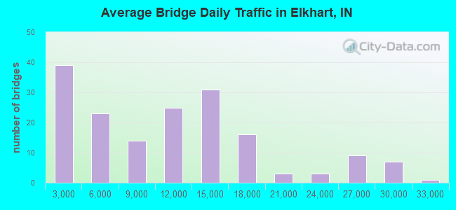
- 1,771,725Total average daily traffic
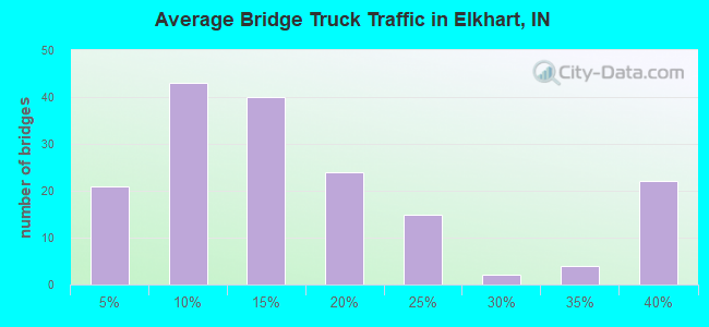
- 343,210Total average daily truck traffic
- National Bridge Inventory (NBI) Registered Bridges for Elkhart
- No street view available for this location
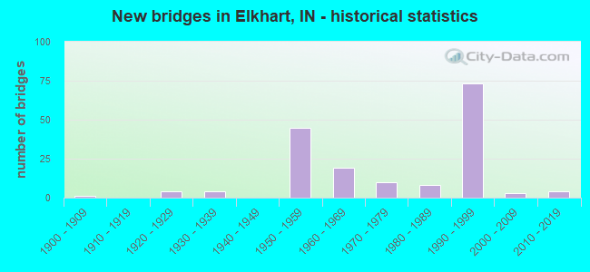
- New bridges - historical statistics
- 11900-1909
- 41920-1929
- 41930-1939
- 451950-1959
- 191960-1969
- 101970-1979
- 81980-1989
- 731990-1999
- 32000-2009
- 42010-2019
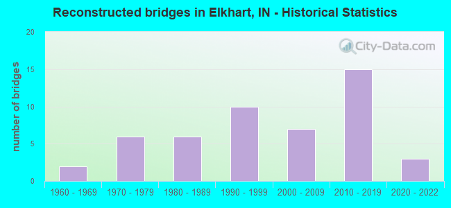
- Reconstructed bridges - Historical Statistics
- 21960-1969
- 61970-1979
- 61980-1989
- 101990-1999
- 72000-2009
- 152010-2019
- 32020-2022
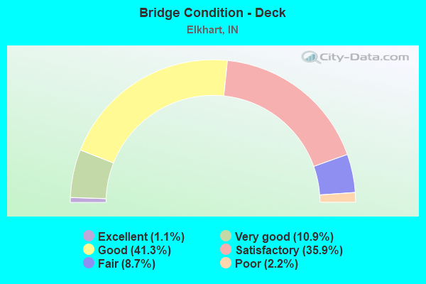
- Bridge Condition - Deck
- 1.1%Excellent
- 10.9%Very good
- 41.3%Good
- 35.9%Satisfactory
- 8.7%Fair
- 2.2%Poor
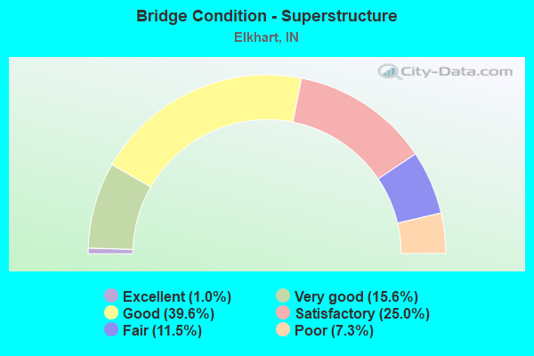
- Bridge Condition - Superstructure
- 1.0%Excellent
- 15.6%Very good
- 39.6%Good
- 25.0%Satisfactory
- 11.5%Fair
- 7.3%Poor
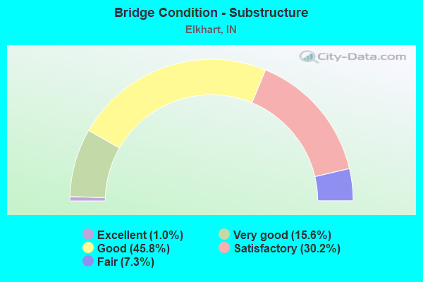
- Bridge Condition - Substructure
- 1.0%Excellent
- 15.6%Very good
- 45.8%Good
- 30.2%Satisfactory
- 7.3%Fair
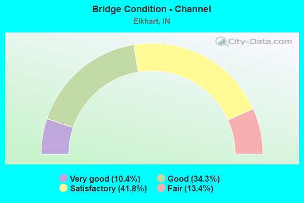
- Bridge Condition - Channel
- 10.4%Very good
- 34.3%Good
- 41.8%Satisfactory
- 13.4%Fair
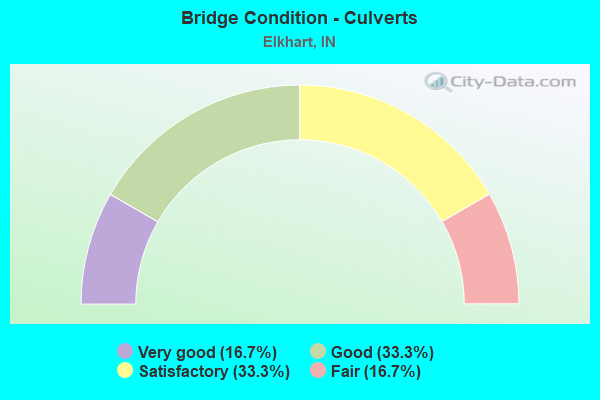
- Bridge Condition - Culverts
- 16.7%Very good
- 33.3%Good
- 33.3%Satisfactory
- 16.7%Fair
Find on map >> Show street view
Structure Number: 48076, Location: 04.42 E SR 19 (Lat: 41.730531, Lng: -85.884911), Route carried "under" structure: Interstate 90, Year Built: 1997, Structure Length: 0. m, Average Daily Traffic: 12,250 (year 2011), Truck Traffic: 14%, Features Intersected: I-90
Minimum Vertical Clearance: 5.03m (16.50ft), Kilometerpoint: 154.658, Lanes on structure: 2, Lanes under structure: 5, Toll: On toll road, Material/Design: Steel continuous, Length of Maximum Span: 35.3m (115.8ft)
Find on map >> Show street view
Structure Number: 48076, Location: 04.42 E SR 19 (Lat: 41.730531, Lng: -85.884911), Route carried "under" structure: Interstate 90, Year Built: 1997, Structure Length: 0. m, Average Daily Traffic: 12,250 (year 2011), Truck Traffic: 14%, Features Intersected: 1-90 WBL
Minimum Vertical Clearance: 5.03m (16.50ft), Kilometerpoint: 154.658, Lanes on structure: 2, Lanes under structure: 5, Toll: On toll road, Material/Design: Steel continuous, Length of Maximum Span: 35.3m (115.8ft)
Find on map >> Show street view
Structure Number: 7511, Location: 01.14 W SR-19 (Lat: 41.626300, Lng: -86.023803), Route carried "under" structure: US 20, Year Built: 1991, Structure Length: 0. m, Average Daily Traffic: 17,398 (year 2020), Truck Traffic: 19%, Features Intersected: US 20 EB, Facility Carried by Structure: CR 3
Minimum Vertical Clearance: 5.41m (17.75ft), Kilometerpoint: 3.299, Lanes on structure: 2, Lanes under structure: 4, Material/Design: Steel continuous, Design/Construction: Stringer/Multi-beam, Length of Maximum Span: 32.9m (107.9ft)
Find on map >> Show street view
Structure Number: 7511, Location: 01.14 W SR-19 (Lat: 41.626300, Lng: -86.023803), Route carried "under" structure: US 20, Year Built: 1991, Structure Length: 0. m, Average Daily Traffic: 17,094 (year 2020), Truck Traffic: 19%, Features Intersected: US 20 WB, Facility Carried by Structure: CR 3
Minimum Vertical Clearance: 5.41m (17.75ft), Kilometerpoint: 3.299, Lanes on structure: 2, Lanes under structure: 4, Material/Design: Steel continuous, Design/Construction: Stringer/Multi-beam, Length of Maximum Span: 32.9m (107.9ft)
Find on map >> Show street view
Structure Number: 7514, Location: 00.58 W SR-19 (Lat: 41.628869, Lng: -86.013481), Route carried "under" structure: US 20, Year Built: 1991, Structure Length: 0. m, Average Daily Traffic: 17,246 (year 2020), Truck Traffic: 15%, Features Intersected: US 20 WB, Facility Carried by Structure: CR 22
Minimum Vertical Clearance: 5.18m (16.99ft), Kilometerpoint: 4.200, Lanes on structure: 2, Lanes under structure: 4, Material/Design: Steel continuous, Design/Construction: Stringer/Multi-beam, Length of Maximum Span: 32.3m (106.0ft)
Find on map >> Show street view
Structure Number: 7514, Location: 00.58 W SR-19 (Lat: 41.628869, Lng: -86.013481), Route carried "under" structure: US 20, Year Built: 1991, Structure Length: 0. m, Average Daily Traffic: 17,246 (year 2020), Truck Traffic: 15%, Features Intersected: US 20 EB, Facility Carried by Structure: CR 22
Minimum Vertical Clearance: 5.18m (16.99ft), Kilometerpoint: 4.200, Lanes on structure: 2, Lanes under structure: 4, Material/Design: Steel continuous, Design/Construction: Stringer/Multi-beam, Length of Maximum Span: 32.3m (106.0ft)
Find on map >> Show street view
Structure Number: 7515, Location: 09.15 S of I-90 (Lat: 41.631361, Lng: -86.002692), Route carried "under" structure: US 20, Year Built: 1991, Structure Length: 0. m, Average Daily Traffic: 15,323 (year 2020), Truck Traffic: 18%, Features Intersected: US 20 WB, Facility Carried by Structure: SR 19
Minimum Vertical Clearance: 5.11m (16.77ft), Kilometerpoint: 5.134, Lanes on structure: 5, Lanes under structure: 5, Material/Design: Steel continuous, Design/Construction: Stringer/Multi-beam, Length of Maximum Span: 33.7m (110.6ft)
Find on map >> Show street view
Structure Number: 7515, Location: 09.15 S of I-90 (Lat: 41.631361, Lng: -86.002692), Route carried "under" structure: US 20, Year Built: 1991, Structure Length: 0. m, Average Daily Traffic: 15,323 (year 2020), Truck Traffic: 18%, Features Intersected: US 20 EB, Facility Carried by Structure: SR 19
Minimum Vertical Clearance: 5.11m (16.77ft), Kilometerpoint: 5.134, Lanes on structure: 5, Lanes under structure: 5, Material/Design: Steel continuous, Design/Construction: Stringer/Multi-beam, Length of Maximum Span: 33.7m (110.6ft)
Find on map >> Show street view
Structure Number: 7516, Location: 00.99 E SR-19 (Lat: 41.635811, Lng: -85.984467), Route carried "under" structure: US 20, Year Built: 1992, Structure Length: 0. m, Average Daily Traffic: 15,323 (year 2020), Truck Traffic: 18%, Features Intersected: US 20 WB, Facility Carried by Structure: CR 7
Minimum Vertical Clearance: 5.36m (17.59ft), Kilometerpoint: 6.727, Lanes on structure: 2, Lanes under structure: 4, Material/Design: Steel continuous, Design/Construction: Stringer/Multi-beam, Length of Maximum Span: 32.9m (107.9ft)
Find on map >> Show street view
Structure Number: 7516, Location: 00.99 E SR-19 (Lat: 41.635811, Lng: -85.984467), Route carried "under" structure: US 20, Year Built: 1992, Structure Length: 0. m, Average Daily Traffic: 15,323 (year 2020), Truck Traffic: 18%, Features Intersected: US 20 EB, Facility Carried by Structure: CR 7
Minimum Vertical Clearance: 5.36m (17.59ft), Kilometerpoint: 6.727, Lanes on structure: 2, Lanes under structure: 4, Material/Design: Steel continuous, Design/Construction: Stringer/Multi-beam, Length of Maximum Span: 32.9m (107.9ft)
Find on map >> Show street view
Structure Number: 7517, Location: 02.06 E SR-19 (Lat: 41.641181, Lng: -85.965117), Route carried "under" structure: County highway , Year Built: 1991, Structure Length: 0. m, Average Daily Traffic: 2,670 (year 2019), Truck Traffic: 8%, Features Intersected: CR 9, Facility Carried by Structure: US 20 EB
Minimum Vertical Clearance: 4.70m (15.42ft), Kilometerpoint: 0.000, Lanes on structure: 2, Lanes under structure: 2, Material/Design: Prestressed concrete continuous, Design/Construction: Stringer/Multi-beam, Length of Maximum Span: 23.2m (76.1ft)
Find on map >> Show street view
Structure Number: 7518, Location: 02.06 E SR-19 (Lat: 41.641331, Lng: -85.965133), Route carried "under" structure: County highway , Year Built: 1991, Structure Length: 0. m, Average Daily Traffic: 3,779 (year 2020), Truck Traffic: 5%, Features Intersected: CR 9, Facility Carried by Structure: US 20 WB
Minimum Vertical Clearance: 4.70m (15.42ft), Kilometerpoint: 0.000, Lanes on structure: 2, Lanes under structure: 2, Material/Design: Prestressed concrete continuous, Design/Construction: Stringer/Multi-beam, Length of Maximum Span: 23.2m (76.1ft)
Find on map >> Show street view
Structure Number: 7519, Location: 02.82 E SR 19 (Lat: 41.646611, Lng: -85.952247), Route carried "under" structure: County highway , Year Built: 1991, Structure Length: 0. m, Average Daily Traffic: 9,262 (year 2021), Truck Traffic: 13%, Features Intersected: CR 20, Facility Carried by Structure: US 20 EB
Minimum Vertical Clearance: 5.11m (16.77ft), Kilometerpoint: 0.000, Lanes on structure: 2, Lanes under structure: 2, Material/Design: Prestressed concrete continuous, Design/Construction: Stringer/Multi-beam, Length of Maximum Span: 19.6m (64.3ft)
Find on map >> Show street view
Structure Number: 752, Location: 02.82 E SR-19 (Lat: 41.646700, Lng: -85.952414), Route carried "under" structure: County highway , Year Built: 1991, Structure Length: 0. m, Average Daily Traffic: 11,403 (year 2015), Truck Traffic: 5%, Features Intersected: CR 20, Facility Carried by Structure: US 20 WB
Minimum Vertical Clearance: 5.05m (16.57ft), Kilometerpoint: 0.000, Lanes on structure: 2, Lanes under structure: 2, Material/Design: Prestressed concrete continuous, Design/Construction: Stringer/Multi-beam, Length of Maximum Span: 19.6m (64.3ft)
Find on map >> Show street view
Structure Number: 7521, Location: 03.51 E SR-19 (Lat: 41.652081, Lng: -85.940636), Route carried "under" structure: US 33, Year Built: 1991, Structure Length: 0. m, Average Daily Traffic: 7,185 (year 2021), Truck Traffic: 4%, Features Intersected: US 33 NB, Facility Carried by Structure: US 20 EB
Minimum Vertical Clearance: 7.77m (25.49ft), Kilometerpoint: 36.307, Lanes on structure: 3, Lanes under structure: 4, Material/Design: Steel continuous, Design/Construction: Stringer/Multi-beam, Length of Maximum Span: 39.6m (129.9ft)
Find on map >> Show street view
Structure Number: 7521, Location: 03.51 E SR-19 (Lat: 41.652081, Lng: -85.940636), Route carried "under" structure: US 33, Year Built: 1991, Structure Length: 0. m, Average Daily Traffic: 7,185 (year 2021), Truck Traffic: 4%, Features Intersected: US 33 SB, Facility Carried by Structure: US 20 EB
Minimum Vertical Clearance: 7.77m (25.49ft), Kilometerpoint: 36.307, Lanes on structure: 3, Lanes under structure: 4, Material/Design: Steel continuous, Design/Construction: Stringer/Multi-beam, Length of Maximum Span: 39.6m (129.9ft)
Find on map >> Show street view
Structure Number: 7522, Location: 03.51 E SR-19 (Lat: 41.652211, Lng: -85.940728), Route carried "under" structure: US 33, Year Built: 1991, Structure Length: 0. m, Average Daily Traffic: 6,035 (year 2015), Truck Traffic: 24%, Features Intersected: US 33 NB, Facility Carried by Structure: US 20 WB
Minimum Vertical Clearance: 7.77m (25.49ft), Kilometerpoint: 36.323, Lanes on structure: 3, Lanes under structure: 4, Material/Design: Steel continuous, Design/Construction: Stringer/Multi-beam, Length of Maximum Span: 39.6m (129.9ft)
Find on map >> Show street view
Structure Number: 7522, Location: 03.51 E SR-19 (Lat: 41.652211, Lng: -85.940728), Route carried "under" structure: US 33, Year Built: 1991, Structure Length: 0. m, Average Daily Traffic: 6,035 (year 2015), Truck Traffic: 24%, Features Intersected: US 33 SB, Facility Carried by Structure: US 20 WB
Minimum Vertical Clearance: 7.77m (25.49ft), Kilometerpoint: 36.323, Lanes on structure: 3, Lanes under structure: 4, Material/Design: Steel continuous, Design/Construction: Stringer/Multi-beam, Length of Maximum Span: 39.6m (129.9ft)
Find on map >> Show street view
Structure Number: 7523, Location: 00.13 E US-33 (Lat: 41.652931, Lng: -85.938806), Route carried "under" structure: County highway , Year Built: 1992, Structure Length: 0. m, Average Daily Traffic: 3,467 (year 2021), Truck Traffic: 7%, Features Intersected: CR 45, Facility Carried by Structure: US 20 EB
Minimum Vertical Clearance: 6.93m (22.74ft), Kilometerpoint: 0.000, Lanes on structure: 3, Lanes under structure: 2, Material/Design: Prestressed concrete continuous, Design/Construction: Stringer/Multi-beam, Length of Maximum Span: 18.6m (61.0ft)
Find on map >> Show street view
Structure Number: 7524, Location: 00.13 E US-33 (Lat: 41.653039, Lng: -85.938928), Route carried "under" structure: County highway , Year Built: 1992, Structure Length: 0. m, Average Daily Traffic: 3,467 (year 2021), Truck Traffic: 7%, Features Intersected: CR 45, Facility Carried by Structure: US 20 WB
Minimum Vertical Clearance: 6.93m (22.74ft), Kilometerpoint: 0.000, Lanes on structure: 3, Lanes under structure: 2, Material/Design: Prestressed concrete continuous, Design/Construction: Stringer/Multi-beam, Length of Maximum Span: 18.6m (61.0ft)
Find on map >> Show street view
Structure Number: 7526, Location: 01.09 E US-33 (Lat: 41.657089, Lng: -85.921731), Route carried "under" structure: County highway , Year Built: 1991, Structure Length: 0. m, Average Daily Traffic: 6,513 (year 2021), Truck Traffic: 2%, Features Intersected: CR 13, Facility Carried by Structure: US 20 EB
Minimum Vertical Clearance: 4.52m (14.83ft), Kilometerpoint: 0.000, Lanes on structure: 2, Lanes under structure: 2, Material/Design: Prestressed concrete continuous, Design/Construction: Stringer/Multi-beam, Length of Maximum Span: 19.0m (62.3ft)
Find on map >> Show street view
Structure Number: 75265, Location: 01.09 E US-33 (Lat: 41.657219, Lng: -85.921739), Route carried "under" structure: County highway , Year Built: 1991, Structure Length: 0. m, Average Daily Traffic: 6,513 (year 2021), Truck Traffic: 2%, Features Intersected: CR 13, Facility Carried by Structure: US 20 WB
Minimum Vertical Clearance: 4.50m (14.76ft), Kilometerpoint: 0.000, Lanes on structure: 2, Lanes under structure: 2, Material/Design: Prestressed concrete continuous, Design/Construction: Stringer/Multi-beam, Length of Maximum Span: 19.0m (62.3ft)
Find on map >> Show street view
Structure Number: 7528, Location: 01.47 E US-33 (Lat: 41.657281, Lng: -85.914414), Route carried "under" structure: US 20, Year Built: 1991, Structure Length: 0. m, Average Daily Traffic: 10,281 (year 2020), Truck Traffic: 20%, Features Intersected: US 20 WB, Facility Carried by Structure: CR 115
Minimum Vertical Clearance: 5.13m (16.83ft), Kilometerpoint: 13.148, Lanes on structure: 2, Lanes under structure: 4, Material/Design: Steel continuous, Design/Construction: Stringer/Multi-beam, Length of Maximum Span: 34.3m (112.5ft)
Find on map >> Show street view
Structure Number: 7528, Location: 01.47 E US-33 (Lat: 41.657281, Lng: -85.914414), Route carried "under" structure: US 20, Year Built: 1991, Structure Length: 0. m, Average Daily Traffic: 10,281 (year 2020), Truck Traffic: 20%, Features Intersected: US 20 EB, Facility Carried by Structure: CR 115
Minimum Vertical Clearance: 5.13m (16.83ft), Kilometerpoint: 13.148, Lanes on structure: 2, Lanes under structure: 4, Material/Design: Steel continuous, Design/Construction: Stringer/Multi-beam, Length of Maximum Span: 34.3m (112.5ft)
Find on map >> Show street view
Structure Number: 7529, Location: 02.06 E US-33 (Lat: 41.659539, Lng: -85.903825), Route carried "under" structure: US 20, Year Built: 1991, Structure Length: 0. m, Average Daily Traffic: 14,010 (year 2020), Truck Traffic: 20%, Features Intersected: US 20 WB, Facility Carried by Structure: CR 18
Minimum Vertical Clearance: 6.27m (20.57ft), Kilometerpoint: 14.098, Lanes on structure: 2, Lanes under structure: 4, Material/Design: Steel continuous, Design/Construction: Stringer/Multi-beam, Length of Maximum Span: 46.5m (152.6ft)
Find on map >> Show street view
Structure Number: 7529, Location: 02.06 E US-33 (Lat: 41.659539, Lng: -85.903825), Route carried "under" structure: US 20, Year Built: 1991, Structure Length: 0. m, Average Daily Traffic: 14,010 (year 2020), Truck Traffic: 20%, Features Intersected: US 20 EB, Facility Carried by Structure: CR 18
Minimum Vertical Clearance: 5.28m (17.32ft), Kilometerpoint: 14.098, Lanes on structure: 2, Lanes under structure: 4, Material/Design: Steel continuous, Design/Construction: Stringer/Multi-beam, Length of Maximum Span: 46.5m (152.6ft)
Find on map >> Show street view
Structure Number: 753, Location: 02.74 E US 33 (Lat: 41.666431, Lng: -85.894653), Route carried "under" structure: US 20, Year Built: 1990, Structure Length: 0. m, Average Daily Traffic: 11,647 (year 2021), Truck Traffic: 18%, Features Intersected: US 20 EB
Minimum Vertical Clearance: 5.33m (17.49ft), Kilometerpoint: 15.192, Lanes on structure: 1, Lanes under structure: 5, Material/Design: Steel continuous, Design/Construction: Stringer/Multi-beam, Length of Maximum Span: 50.5m (165.7ft)
Find on map >> Show street view
Structure Number: 753, Location: 02.74 E US 33 (Lat: 41.666431, Lng: -85.894653), Route carried "under" structure: US 20, Year Built: 1990, Structure Length: 0. m, Average Daily Traffic: 11,647 (year 2021), Truck Traffic: 18%, Features Intersected: US 20 WB
Minimum Vertical Clearance: 5.33m (17.49ft), Kilometerpoint: 15.192, Lanes on structure: 1, Lanes under structure: 5, Material/Design: Steel continuous, Design/Construction: Stringer/Multi-beam, Length of Maximum Span: 50.5m (165.7ft)
Find on map >> Show street view
Structure Number: 753, Location: 02.74 E US 33 (Lat: 41.666431, Lng: -85.894653), Route carried "under" structure: Ramp US 20, Year Built: 1990, Structure Length: 0. m, Average Daily Traffic: 4,307 (year 2021), Truck Traffic: 12%, Features Intersected: US 20 WB RAMP
Minimum Vertical Clearance: 5.33m (17.49ft), Kilometerpoint: 15.192, Lanes on structure: 1, Lanes under structure: 5, Material/Design: Steel continuous, Design/Construction: Stringer/Multi-beam, Length of Maximum Span: 50.5m (165.7ft)
Find on map >> Show street view
Structure Number: 7531, Location: 02.88 E US-33 (Lat: 41.667792, Lng: -85.892881), Route carried "under" structure: Ramp County highway , Year Built: 1990, Structure Length: 0. m, Average Daily Traffic: 3,798 (year 2020), Truck Traffic: 25%, Features Intersected: CR 17 NW RAMP, Facility Carried by Structure: US 20 NW CONNECTOR
Minimum Vertical Clearance: 5.21m (17.09ft), Kilometerpoint: 15.418, Lanes on structure: 1, Lanes under structure: 1, Material/Design: Steel continuous, Design/Construction: Stringer/Multi-beam, Length of Maximum Span: 18.6m (61.0ft)
Find on map >> Show street view
Structure Number: 7532, Location: 03.10 E US-33 (Lat: 41.666681, Lng: -85.887483), Route carried "under" structure: County highway , Year Built: 1992, Structure Length: 0. m, Average Daily Traffic: 12,267 (year 2021), Truck Traffic: 11%, Features Intersected: CR 17 NBL, Facility Carried by Structure: US 20 EB RAMP
Minimum Vertical Clearance: 5.08m (16.67ft), Kilometerpoint: 0.000, Lanes on structure: 2, Lanes under structure: 4, Material/Design: Steel continuous, Design/Construction: Stringer/Multi-beam, Length of Maximum Span: 29.1m (95.5ft)
Find on map >> Show street view
Structure Number: 7532, Location: 03.10 E US-33 (Lat: 41.666681, Lng: -85.887483), Route carried "under" structure: County highway , Year Built: 1992, Structure Length: 0. m, Average Daily Traffic: 12,267 (year 2021), Truck Traffic: 11%, Features Intersected: CR 17 SBL, Facility Carried by Structure: US 20 EB RAMP
Minimum Vertical Clearance: 5.08m (16.67ft), Kilometerpoint: 0.000, Lanes on structure: 2, Lanes under structure: 4, Material/Design: Steel continuous, Design/Construction: Stringer/Multi-beam, Length of Maximum Span: 29.1m (95.5ft)
Find on map >> Show street view
Structure Number: 7533, Location: 03.10 E US-33 (Lat: 41.666811, Lng: -85.887489), Route carried "under" structure: County highway , Year Built: 1992, Structure Length: 0. m, Average Daily Traffic: 12,267 (year 2021), Truck Traffic: 11%, Features Intersected: CR 17 NBL, Facility Carried by Structure: US 20 EB
Minimum Vertical Clearance: 5.23m (17.16ft), Kilometerpoint: 0.000, Lanes on structure: 2, Lanes under structure: 4, Material/Design: Steel continuous, Design/Construction: Stringer/Multi-beam, Length of Maximum Span: 29.1m (95.5ft)
Find on map >> Show street view
Structure Number: 7533, Location: 03.10 E US-33 (Lat: 41.666811, Lng: -85.887489), Route carried "under" structure: County highway , Year Built: 1992, Structure Length: 0. m, Average Daily Traffic: 12,267 (year 2021), Truck Traffic: 11%, Features Intersected: CR 17 SBL, Facility Carried by Structure: US 20 EB
Minimum Vertical Clearance: 5.23m (17.16ft), Kilometerpoint: 0.000, Lanes on structure: 2, Lanes under structure: 4, Material/Design: Steel continuous, Design/Construction: Stringer/Multi-beam, Length of Maximum Span: 29.1m (95.5ft)
Find on map >> Show street view
Structure Number: 75335, Location: 03.10 E US-33 (Lat: 41.666961, Lng: -85.887497), Route carried "under" structure: County highway , Year Built: 1992, Structure Length: 0. m, Average Daily Traffic: 12,267 (year 2021), Truck Traffic: 11%, Features Intersected: CR 17 NBL, Facility Carried by Structure: US 20 WB
Minimum Vertical Clearance: 5.31m (17.42ft), Kilometerpoint: 0.000, Lanes on structure: 3, Lanes under structure: 4, Material/Design: Steel continuous, Design/Construction: Stringer/Multi-beam, Length of Maximum Span: 29.1m (95.5ft)
Find on map >> Show street view
Structure Number: 75335, Location: 03.10 E US-33 (Lat: 41.666961, Lng: -85.887497), Route carried "under" structure: County highway , Year Built: 1992, Structure Length: 0. m, Average Daily Traffic: 12,267 (year 2021), Truck Traffic: 11%, Features Intersected: CR 17 SBL, Facility Carried by Structure: US 20 WB
Minimum Vertical Clearance: 3.18m (10.43ft), Kilometerpoint: 0.000, Lanes on structure: 3, Lanes under structure: 4, Material/Design: Steel continuous, Design/Construction: Stringer/Multi-beam, Length of Maximum Span: 29.1m (95.5ft)