Bridge Statistics for Elmhurst, Illinois (IL)
Condition, Traffic, Stress, Structural Evaluation, Project Costs
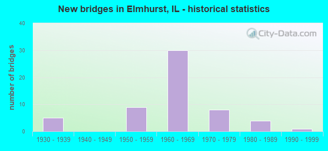
- New bridges - historical statistics
- 51930-1939
- 91950-1959
- 301960-1969
- 81970-1979
- 41980-1989
- 11990-1999
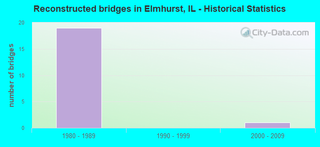
- Reconstructed bridges - Historical Statistics
- 191980-1989
- 01990-1999
- 12000-2009
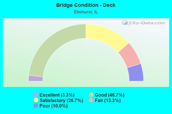
- Bridge Condition - Deck
- 3.3%Excellent
- 46.7%Good
- 26.7%Satisfactory
- 13.3%Fair
- 10.0%Poor
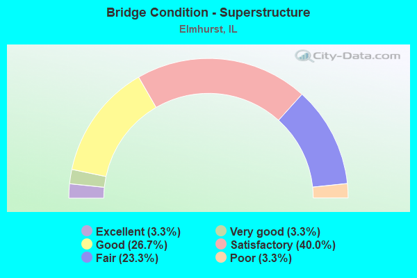
- Bridge Condition - Superstructure
- 3.3%Excellent
- 3.3%Very good
- 26.7%Good
- 40.0%Satisfactory
- 23.3%Fair
- 3.3%Poor
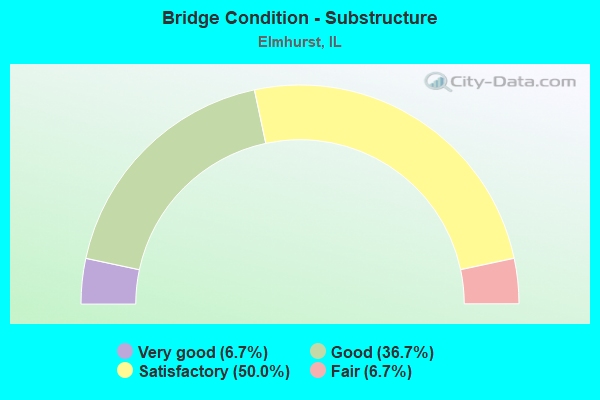
- Bridge Condition - Substructure
- 6.7%Very good
- 36.7%Good
- 50.0%Satisfactory
- 6.7%Fair
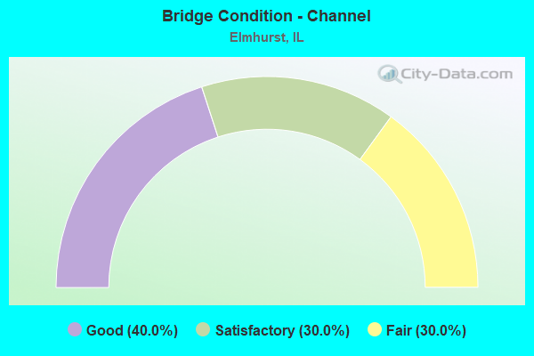
- Bridge Condition - Channel
- 40.0%Good
- 30.0%Satisfactory
- 30.0%Fair
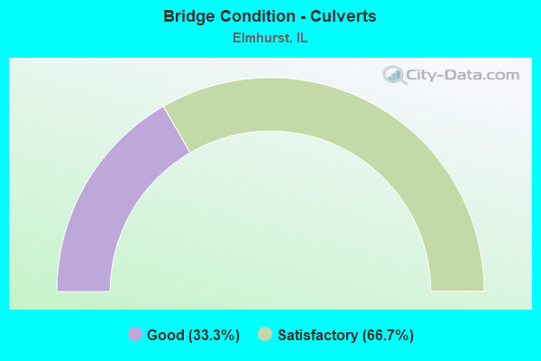
- Bridge Condition - Culverts
- 33.3%Good
- 66.7%Satisfactory
Find on map >> Show street view
Structure Number: 1133, Location: 1.8 M E PALMER (Lat: 39.462028, Lng: -89.365356), Route carried "on" structure: County highway , Year Built: 1981, Status: Open, Structure Length: 1.64m (5.38ft), Average Daily Traffic: 50 (year 2021), Truck Traffic: 16%, Average Future Daily Traffic: 50 (year 2032), Design Load: HS 20, Features Intersected: BRUSH CREEK, Facility Carried by Structure: TR 106
Minimum Vertical Clearance: 30+ m (98+ ft), Kilometerpoint: 3.862, Lanes on structure: 2, Owner: Town or Township Highway Agency, Approaching Roadway Width: 3.7m (12.1ft), Skew: 1 degrees, Material/Design: Concrete, Design/Construction: Channel Beam, Number Of Spans In Main Unit: 2, Length of Maximum Span: 7.7m (25.3ft), Curb-To-Curb Width: 8.0m (26.2ft), Out-to-Out Width: 8.0m (26.2ft)
Condition: Deck: Satisfactory, Superstructure: Satisfactory, Substructure: Fair, Channel: Fair, Operating Rating: 60.6 metric tons, Method Used To Determine Operating Rating: Load Factor (LF) rating reported by rating factor (RF) method using MS18 loading, Inventory Rating: 36.3 metric tons, Method Used To Determine Inventory Rating: Load Factor (LF) rating reported by rating factor (RF) method using MS18 loading, Structural Evaluation: Somewhat better than minimum adequacy, Deck Geometry: Equal to present minimum criteria, Waterway Adequacy: Equal to present desirable criteria, Approach Roadway Alignment: Equal to present desirable criteria, Designated Inspection Frequency: Every 24 months, Inspection Date: November 2019, Deck Structure Type: Concrete Precast Panels
Find on map >> Show street view
Structure Number: 16113, Location: 0.5 M S IL 64 (Lat: 41.899042, Lng: -87.920606), Route carried "on" structure: Interstate 290, Year Built: 1950, Year Reconstructed: 1985, Status: Open, Structure Length: 7.59m (24.90ft), Average Daily Traffic: 57,400 (year 2021), Truck Traffic: 15%, Average Future Daily Traffic: 75,087 (year 2032), Design Load: HS 20, Features Intersected: RR - UP (NORTH)
Minimum Vertical Clearance: 30+ m (98+ ft), Kilometerpoint: 22.498, Lanes on structure: 2, Base Highway Network: Yes, Owner: State Highway Agency, Approaching Roadway Width: 11.0m (36.1ft), Material/Design: Steel continuous, Design/Construction: Stringer/Multi-beam, Number Of Spans In Main Unit: 3, Length of Maximum Span: 28.7m (94.2ft), Curb-To-Curb Width: 9.1m (29.9ft), Out-to-Out Width: 11.0m (36.1ft)
Condition: Deck: Satisfactory, Superstructure: Fair, Substructure: Satisfactory, Operating Rating: 63.8 metric tons, Method Used To Determine Operating Rating: Load Factor (LF) rating reported by rating factor (RF) method using MS18 loading, Inventory Rating: 33.7 metric tons, Method Used To Determine Inventory Rating: Load Factor (LF) rating reported by rating factor (RF) method using MS18 loading, Structural Evaluation: Somewhat better than minimum adequacy, Deck Geometry: Meets minimum limits, Underclear: Somewhat better than minimum adequacy, Approach Roadway Alignment: Equal to present desirable criteria, Designated Inspection Frequency: Every 24 months, Inspection Date: August 2020, Deck Structure Type: Concrete Cast-file-Place, Wearing Surface/Protective System: Wearing Surface: Latex Concrete, Deck Protection: Epoxy Coated Reinforcing
Find on map >> Show street view
Structure Number: 161131, Location: 0.5 M S IL 64 (Lat: 41.898906, Lng: -87.920606), Route carried "on" structure: Interstate 290, Year Built: 1958, Year Reconstructed: 1985, Status: Open, Structure Length: 7.59m (24.90ft), Average Daily Traffic: 57,400 (year 2021), Truck Traffic: 15%, Average Future Daily Traffic: 75,087 (year 2032), Design Load: HS 20, Features Intersected: RR - UP (NORTH)
Minimum Vertical Clearance: 30+ m (98+ ft), Kilometerpoint: 22.514, Lanes on structure: 2, Base Highway Network: Yes, Owner: State Highway Agency, Approaching Roadway Width: 11.0m (36.1ft), Material/Design: Steel continuous, Design/Construction: Stringer/Multi-beam, Number Of Spans In Main Unit: 3, Length of Maximum Span: 28.7m (94.2ft), Curb-To-Curb Width: 9.1m (29.9ft), Out-to-Out Width: 11.0m (36.1ft)
Condition: Deck: Satisfactory, Superstructure: Fair, Substructure: Satisfactory, Operating Rating: 63.8 metric tons, Method Used To Determine Operating Rating: Load Factor (LF) rating reported by rating factor (RF) method using MS18 loading, Inventory Rating: 33.7 metric tons, Method Used To Determine Inventory Rating: Load Factor (LF) rating reported by rating factor (RF) method using MS18 loading, Structural Evaluation: Somewhat better than minimum adequacy, Deck Geometry: Meets minimum limits, Underclear: Somewhat better than minimum adequacy, Approach Roadway Alignment: Equal to present desirable criteria, Designated Inspection Frequency: Every 24 months, Inspection Date: August 2020, Deck Structure Type: Concrete Cast-file-Place, Wearing Surface/Protective System: Wearing Surface: Latex Concrete, Deck Protection: Epoxy Coated Reinforcing
Find on map >> Show street view
Structure Number: 161132, Location: 0.6 M S IL 64 (Lat: 41.897128, Lng: -87.920581), Route carried "on" structure: Interstate 290, Year Built: 1958, Year Reconstructed: 1985, Status: Open, Structure Length: 10.73m (35.20ft), Average Daily Traffic: 57,400 (year 2021), Truck Traffic: 15%, Average Future Daily Traffic: 75,087 (year 2032), Design Load: HS 20, Features Intersected: RR - UP (SOUTH)
Minimum Vertical Clearance: 30+ m (98+ ft), Kilometerpoint: 22.723, Lanes on structure: 2, Base Highway Network: Yes, Owner: State Highway Agency, Approaching Roadway Width: 11.0m (36.1ft), Material/Design: Steel continuous, Design/Construction: Stringer/Multi-beam, Number Of Spans In Main Unit: 5, Length of Maximum Span: 28.3m (92.8ft), Curb-To-Curb Width: 9.1m (29.9ft), Out-to-Out Width: 11.0m (36.1ft)
Condition: Deck: Good, Superstructure: Fair, Substructure: Good, Operating Rating: 56.4 metric tons, Method Used To Determine Operating Rating: Load Factor (LF) rating reported by rating factor (RF) method using MS18 loading, Inventory Rating: 32.4 metric tons, Method Used To Determine Inventory Rating: Load Factor (LF) rating reported by rating factor (RF) method using MS18 loading, Structural Evaluation: Somewhat better than minimum adequacy, Deck Geometry: Meets minimum limits, Underclear: Better than present minimum criteria, Approach Roadway Alignment: Equal to present desirable criteria, Designated Inspection Frequency: Every 24 months, Inspection Date: August 2020, Deck Structure Type: Concrete Cast-file-Place, Wearing Surface/Protective System: Wearing Surface: Latex Concrete, Deck Protection: Epoxy Coated Reinforcing
Find on map >> Show street view
Structure Number: 161133, Location: 0.6 M S IL 64 (Lat: 41.897264, Lng: -87.920583), Route carried "on" structure: Interstate 290, Year Built: 1958, Year Reconstructed: 1985, Status: Open, Structure Length: 10.73m (35.20ft), Average Daily Traffic: 57,400 (year 2021), Truck Traffic: 15%, Average Future Daily Traffic: 75,087 (year 2032), Design Load: HS 20, Features Intersected: RR - UP (SOUTH)
Minimum Vertical Clearance: 30+ m (98+ ft), Kilometerpoint: 22.707, Lanes on structure: 2, Base Highway Network: Yes, Owner: State Highway Agency, Approaching Roadway Width: 11.0m (36.1ft), Material/Design: Steel continuous, Design/Construction: Stringer/Multi-beam, Number Of Spans In Main Unit: 5, Length of Maximum Span: 28.3m (92.8ft), Curb-To-Curb Width: 9.1m (29.9ft), Out-to-Out Width: 11.0m (36.1ft)
Condition: Deck: Good, Superstructure: Poor, Substructure: Satisfactory, Operating Rating: 45.0 metric tons, Method Used To Determine Operating Rating: Load Factor (LF) rating reported by rating factor (RF) method using MS18 loading, Inventory Rating: 27.2 metric tons, Method Used To Determine Inventory Rating: Load Factor (LF) rating reported by rating factor (RF) method using MS18 loading, Structural Evaluation: Meets minimum limits, Deck Geometry: Meets minimum limits, Underclear: Equal to present minimum criteria, Approach Roadway Alignment: Equal to present desirable criteria, Designated Inspection Frequency: Every 12 months, Inspection Date: August 2021, Deck Structure Type: Concrete Cast-file-Place, Wearing Surface/Protective System: Wearing Surface: Latex Concrete, Deck Protection: Epoxy Coated Reinforcing
Find on map >> Show street view
Structure Number: 161134, Location: 1.5 M S IL 64 (Lat: 41.883008, Lng: -87.920608), Route carried "on" structure: Interstate 290, Year Built: 1952, Year Reconstructed: 1985, Status: Open, Structure Length: 11.58m (37.99ft), Average Daily Traffic: 54,100 (year 2021), Truck Traffic: 11%, Average Future Daily Traffic: 74,006 (year 2032), Design Load: HS 20+Mod, Features Intersected: ELECTRIC AV&PRAIRIE
Minimum Vertical Clearance: 30+ m (98+ ft), Kilometerpoint: 24.333, Lanes on structure: 2, Lanes under structure: 2, Base Highway Network: Yes, Owner: State Highway Agency, Approaching Roadway Width: 11.0m (36.1ft), Material/Design: Steel continuous, Design/Construction: Stringer/Multi-beam, Number Of Spans In Main Unit: 5, Length of Maximum Span: 26.2m (86.0ft), Curb-To-Curb Width: 9.1m (29.9ft), Out-to-Out Width: 11.0m (36.1ft)
Condition: Deck: Fair, Superstructure: Fair, Substructure: Satisfactory, Operating Rating: 53.8 metric tons, Method Used To Determine Operating Rating: Load Factor (LF) rating reported by rating factor (RF) method using MS18 loading, Inventory Rating: 32.1 metric tons, Method Used To Determine Inventory Rating: Load Factor (LF) rating reported by rating factor (RF) method using MS18 loading, Structural Evaluation: Somewhat better than minimum adequacy, Deck Geometry: Meets minimum limits, Underclear: Meets minimum limits, Approach Roadway Alignment: Equal to present desirable criteria, Designated Inspection Frequency: Every 24 months, Inspection Date: December 2021, Deck Structure Type: Concrete Cast-file-Place, Wearing Surface/Protective System: Wearing Surface: Latex Concrete, Deck Protection: Epoxy Coated Reinforcing
Find on map >> Show street view
Structure Number: 161135, Location: 1.5 M S IL 64 (Lat: 41.882861, Lng: -87.920611), Route carried "on" structure: Interstate 290, Year Built: 1952, Year Reconstructed: 1985, Status: Open, Structure Length: 11.58m (37.99ft), Average Daily Traffic: 54,100 (year 2021), Truck Traffic: 11%, Average Future Daily Traffic: 74,006 (year 2032), Design Load: HS 20+Mod, Features Intersected: ELECTRIC AV&PRAIRIE
Minimum Vertical Clearance: 30+ m (98+ ft), Kilometerpoint: 24.349, Lanes on structure: 2, Lanes under structure: 2, Base Highway Network: Yes, Owner: State Highway Agency, Approaching Roadway Width: 11.0m (36.1ft), Material/Design: Steel continuous, Design/Construction: Stringer/Multi-beam, Number Of Spans In Main Unit: 5, Length of Maximum Span: 26.2m (86.0ft), Curb-To-Curb Width: 9.1m (29.9ft), Out-to-Out Width: 11.0m (36.1ft)
Condition: Deck: Fair, Superstructure: Fair, Substructure: Satisfactory, Operating Rating: 53.8 metric tons, Method Used To Determine Operating Rating: Load Factor (LF) rating reported by rating factor (RF) method using MS18 loading, Inventory Rating: 32.1 metric tons, Method Used To Determine Inventory Rating: Load Factor (LF) rating reported by rating factor (RF) method using MS18 loading, Structural Evaluation: Somewhat better than minimum adequacy, Deck Geometry: Meets minimum limits, Underclear: Meets minimum limits, Approach Roadway Alignment: Equal to present desirable criteria, Designated Inspection Frequency: Every 24 months, Inspection Date: December 2021, Deck Structure Type: Concrete Cast-file-Place, Wearing Surface/Protective System: Wearing Surface: Latex Concrete, Deck Protection: Epoxy Coated Reinforcing
Find on map >> Show street view
Structure Number: 161136, Location: 1.1 M S IL 64 (Lat: 41.889742, Lng: -87.920400), Route carried "on" structure: Other road , Year Built: 1960, Year Reconstructed: 2021, Status: Open, Structure Length: 7.07m (23.20ft), Average Daily Traffic: 17,100 (year 2018), Truck Traffic: 7%, Average Future Daily Traffic: 17,922 (year 2032), Design Load: HS 20, Features Intersected: I-290, Facility Carried by Structure: ST CHARLES RD
Minimum Vertical Clearance: 30+ m (98+ ft), Kilometerpoint: 0.016, Lanes on structure: 6, Lanes under structure: 6, Base Highway Network: Yes, Owner: State Highway Agency, Approaching Roadway Width: 14.6m (47.9ft), Skew: 30 degrees, Material/Design: Steel continuous, Design/Construction: Stringer/Multi-beam, Number Of Spans In Main Unit: 4, Length of Maximum Span: 22.3m (73.2ft), Curb or Sidewalk Widths: Left: 1.5m (4.9ft), Right: 1.5m (4.9ft), Curb-To-Curb Width: 26.1m (85.6ft), Out-to-Out Width: 31.0m (101.7ft)
Condition: Deck: Poor, Superstructure: Satisfactory, Substructure: Fair, Operating Rating: 50.5 metric tons, Method Used To Determine Operating Rating: Load Factor (LF) rating reported by rating factor (RF) method using MS18 loading, Inventory Rating: 30.1 metric tons, Method Used To Determine Inventory Rating: Load Factor (LF) rating reported by rating factor (RF) method using MS18 loading, Structural Evaluation: Somewhat better than minimum adequacy, Deck Geometry: Equal to present minimum criteria, Underclear: Meets minimum limits, Approach Roadway Alignment: Equal to present desirable criteria, Length Of Structure Improvement: 7.07m (23.20ft), Designated Inspection Frequency: Every 24 months, Inspection Date: July 2020, Bridge Improvement Cost: $1,620,000, Roadway Improvement Cost: $162,000, Total Project Cost: $2,430,000, Deck Structure Type: Concrete Cast-file-Place, Wearing Surface/Protective System: Wearing Surface: Integral Concrete
Find on map >> Show street view
Structure Number: 163262, Location: 0.2 MI. SO. GRAND AV (Lat: 41.926300, Lng: -87.920314), Route carried "on" structure: Other road , Year Built: 1993, Status: Open, Structure Length: 0.83m (2.72ft), Average Daily Traffic: 4,950 (year 2018), Truck Traffic: 26%, Average Future Daily Traffic: 7,622 (year 2032), Design Load: HS 20, Features Intersected: ADDISON CREEK, Facility Carried by Structure: MT. PROSPECT ROAD
Minimum Vertical Clearance: 30+ m (98+ ft), Kilometerpoint: 2.575, Lanes on structure: 2, Base Highway Network: Yes, Owner: County Highway Agency, Approaching Roadway Width: 9.1m (29.9ft), Material/Design: Concrete, Design/Construction: Culvert, Number Of Spans In Main Unit: 3, Length of Maximum Span: 3.0m (9.8ft)
Condition: Channel: Satisfactory, Culverts: Good, Operating Rating: 54.1 metric tons, Method Used To Determine Operating Rating: Field evaluation and documented engineering judgment, Inventory Rating: 32.4 metric tons, Method Used To Determine Inventory Rating: Field evaluation and documented engineering judgment, Structural Evaluation: Better than present minimum criteria, Waterway Adequacy: Superior to present desirable criteria, Approach Roadway Alignment: Equal to present desirable criteria, Designated Inspection Frequency: Every 48 months, Inspection Date: July 2019
Find on map >> Show street view
Structure Number: 220005, Location: 1.0 M NW OF IL 64 (Lat: 41.914367, Lng: -87.939867), Route carried "on" structure: Interstate 290, Year Built: 1963, Year Reconstructed: 1985, Status: Open, Structure Length: 5.46m (17.91ft), Average Daily Traffic: 57,150 (year 2021), Truck Traffic: 22%, Average Future Daily Traffic: 75,084 (year 2032), Design Load: HS 20+Mod, Features Intersected: YORK RD
Minimum Vertical Clearance: 30+ m (98+ ft), Kilometerpoint: 20.020, Lanes on structure: 5, Lanes under structure: 4, Base Highway Network: Yes, Owner: State Highway Agency, Approaching Roadway Width: 17.7m (58.1ft), Skew: 2 degrees, Material/Design: Steel continuous, Design/Construction: Stringer/Multi-beam, Number Of Spans In Main Unit: 4, Length of Maximum Span: 14.0m (45.9ft), Curb-To-Curb Width: 22.6m (74.1ft), Out-to-Out Width: 23.8m (78.1ft)
Condition: Deck: Satisfactory, Superstructure: Satisfactory, Substructure: Good, Operating Rating: 54.8 metric tons, Method Used To Determine Operating Rating: Load Factor (LF) rating reported by rating factor (RF) method using MS18 loading, Inventory Rating: 32.7 metric tons, Method Used To Determine Inventory Rating: Load Factor (LF) rating reported by rating factor (RF) method using MS18 loading, Structural Evaluation: Equal to present minimum criteria, Deck Geometry: Meets minimum limits, Underclear: Somewhat better than minimum adequacy, Approach Roadway Alignment: Equal to present desirable criteria, Designated Inspection Frequency: Every 24 months, Inspection Date: December 2021, Deck Structure Type: Concrete Cast-file-Place, Wearing Surface/Protective System: Wearing Surface: Latex Concrete, Deck Protection: Epoxy Coated Reinforcing
Find on map >> Show street view
Structure Number: 220006, Location: 1.0 M NW OF IL 64 (Lat: 41.914303, Lng: -87.939708), Route carried "on" structure: Interstate 290, Year Built: 1963, Year Reconstructed: 1985, Status: Open, Structure Length: 5.46m (17.91ft), Average Daily Traffic: 57,150 (year 2021), Truck Traffic: 22%, Average Future Daily Traffic: 92,072 (year 2032), Design Load: HS 20+Mod, Features Intersected: YORK RD
Minimum Vertical Clearance: 30+ m (98+ ft), Kilometerpoint: 20.036, Lanes on structure: 5, Lanes under structure: 4, Base Highway Network: Yes, Owner: State Highway Agency, Approaching Roadway Width: 17.7m (58.1ft), Skew: 2 degrees, Material/Design: Steel continuous, Design/Construction: Stringer/Multi-beam, Number Of Spans In Main Unit: 4, Length of Maximum Span: 14.0m (45.9ft), Curb-To-Curb Width: 23.5m (77.1ft), Out-to-Out Width: 24.7m (81.0ft)
Condition: Deck: Good, Superstructure: Satisfactory, Substructure: Good, Operating Rating: 54.8 metric tons, Method Used To Determine Operating Rating: Load Factor (LF) rating reported by rating factor (RF) method using MS18 loading, Inventory Rating: 32.7 metric tons, Method Used To Determine Inventory Rating: Load Factor (LF) rating reported by rating factor (RF) method using MS18 loading, Structural Evaluation: Equal to present minimum criteria, Deck Geometry: Equal to present minimum criteria, Underclear: High priority of corrective action, Approach Roadway Alignment: Equal to present desirable criteria, Designated Inspection Frequency: Every 24 months, Inspection Date: December 2021, Deck Structure Type: Concrete Cast-file-Place, Wearing Surface/Protective System: Wearing Surface: Latex Concrete, Deck Protection: Epoxy Coated Reinforcing
Find on map >> Show street view
Structure Number: 220007, Location: 2.9 M NW I-88 (Lat: 41.906664, Lng: -87.923997), Route carried "on" structure: Interstate 290, Year Built: 1960, Year Reconstructed: 1985, Status: Open, Structure Length: 6.86m (22.51ft), Average Daily Traffic: 53,800 (year 2021), Truck Traffic: 23%, Average Future Daily Traffic: 69,625 (year 2032), Design Load: HS 20+Mod, Features Intersected: IL 64
Minimum Vertical Clearance: 30+ m (98+ ft), Kilometerpoint: 21.565, Lanes on structure: 4, Lanes under structure: 7, Base Highway Network: Yes, Owner: State Highway Agency, Approaching Roadway Width: 17.1m (56.1ft), Skew: 34 degrees, Material/Design: Steel continuous, Design/Construction: Stringer/Multi-beam, Number Of Spans In Main Unit: 3, Length of Maximum Span: 28.3m (92.8ft), Curb-To-Curb Width: 17.1m (56.1ft), Out-to-Out Width: 18.3m (60.0ft)
Condition: Deck: Good, Superstructure: Satisfactory, Substructure: Good, Operating Rating: 56.7 metric tons, Method Used To Determine Operating Rating: Load Factor (LF) rating reported by rating factor (RF) method using MS18 loading, Inventory Rating: 34.0 metric tons, Method Used To Determine Inventory Rating: Load Factor (LF) rating reported by rating factor (RF) method using MS18 loading, Structural Evaluation: Equal to present minimum criteria, Deck Geometry: Meets minimum limits, Underclear: High priority of corrective action, Approach Roadway Alignment: Equal to present desirable criteria, Length Of Structure Improvement: 6.86m (22.51ft), Designated Inspection Frequency: Every 24 months, Other Special Inspection Frequency: Every 48 months, Inspection Date: January 2022, Other Special Inspection Date: January 2022, Bridge Improvement Cost: $972,000, Roadway Improvement Cost: $97,000, Total Project Cost: $1,458,000, Deck Structure Type: Concrete Cast-file-Place, Wearing Surface/Protective System: Wearing Surface: Latex Concrete, Deck Protection: Epoxy Coated Reinforcing
Find on map >> Show street view
Structure Number: 220008, Location: 2.9 M NW I-88 (Lat: 41.906556, Lng: -87.923850), Route carried "on" structure: Interstate 290, Year Built: 1960, Year Reconstructed: 1985, Status: Open, Structure Length: 6.80m (22.31ft), Average Daily Traffic: 53,800 (year 2021), Truck Traffic: 23%, Average Future Daily Traffic: 74,248 (year 2032), Design Load: HS 20+Mod, Features Intersected: IL 64
Minimum Vertical Clearance: 30+ m (98+ ft), Kilometerpoint: 21.581, Lanes on structure: 4, Lanes under structure: 7, Base Highway Network: Yes, Owner: State Highway Agency, Approaching Roadway Width: 17.1m (56.1ft), Skew: 4 degrees, Material/Design: Steel continuous, Design/Construction: Stringer/Multi-beam, Number Of Spans In Main Unit: 3, Length of Maximum Span: 28.0m (91.9ft), Curb-To-Curb Width: 17.1m (56.1ft), Out-to-Out Width: 18.3m (60.0ft)
Condition: Deck: Good, Superstructure: Satisfactory, Substructure: Good, Operating Rating: 53.1 metric tons, Method Used To Determine Operating Rating: Load Factor (LF) rating reported by rating factor (RF) method using MS18 loading, Inventory Rating: 31.8 metric tons, Method Used To Determine Inventory Rating: Load Factor (LF) rating reported by rating factor (RF) method using MS18 loading, Structural Evaluation: Equal to present minimum criteria, Deck Geometry: Meets minimum limits, Underclear: High priority of corrective action, Approach Roadway Alignment: Equal to present desirable criteria, Length Of Structure Improvement: 6.80m (22.31ft), Designated Inspection Frequency: Every 24 months, Other Special Inspection Frequency: Every 48 months, Inspection Date: January 2022, Other Special Inspection Date: January 2022, Bridge Improvement Cost: $963,000, Roadway Improvement Cost: $96,000, Total Project Cost: $1,445,000, Deck Structure Type: Concrete Cast-file-Place, Wearing Surface/Protective System: Wearing Surface: Latex Concrete, Deck Protection: Epoxy Coated Reinforcing
Find on map >> Show street view
Structure Number: 220015, Location: .1 MI. W. OF I-290 (Lat: 41.906475, Lng: -87.925789), Route carried "on" structure: Other road , Year Built: 1961, Year Reconstructed: 1985, Status: Open, Structure Length: 6.61m (21.69ft), Average Daily Traffic: 14,800 (year 2021), Truck Traffic: 14%, Average Future Daily Traffic: 26,068 (year 2032), Design Load: HS 20+Mod, Features Intersected: IL 64 (NORTH AVE), Facility Carried by Structure: I-290 EB TO US 20
Minimum Vertical Clearance: 30+ m (98+ ft), Kilometerpoint: 0.338, Lanes on structure: 2, Lanes under structure: 10, Base Highway Network: Yes (Inventory Route: 10290040, Subroute: 30), Owner: State Highway Agency, Approaching Roadway Width: 12.8m (42.0ft), Skew: 3 degrees, Material/Design: Steel continuous, Design/Construction: Stringer/Multi-beam, Number Of Spans In Main Unit: 4, Length of Maximum Span: 17.1m (56.1ft), Curb-To-Curb Width: 13.2m (43.3ft), Out-to-Out Width: 13.4m (44.0ft)
Condition: Deck: Satisfactory, Superstructure: Fair, Substructure: Satisfactory, Operating Rating: 89.4 metric tons, Method Used To Determine Operating Rating: Load Factor (LF) rating reported by rating factor (RF) method using MS18 loading, Inventory Rating: 41.8 metric tons, Method Used To Determine Inventory Rating: Load Factor (LF) rating reported by rating factor (RF) method using MS18 loading, Structural Evaluation: Somewhat better than minimum adequacy, Deck Geometry: Superior to present desirable criteria, Underclear: High priority of corrective action, Approach Roadway Alignment: Equal to present desirable criteria, Designated Inspection Frequency: Every 24 months, Inspection Date: December 2020, Deck Structure Type: Concrete Cast-file-Place, Wearing Surface/Protective System: Wearing Surface: Other
Find on map >> Show street view
Structure Number: 220028, Location: 0.5 E OF IL 83 (Lat: 41.861272, Lng: -87.948406), Route carried "on" structure: Other road , Year Built: 1930, Year Reconstructed: 1986, Status: Open, Structure Length: 4.85m (15.91ft), Average Daily Traffic: 2,650 (year 2020), Truck Traffic: 2%, Average Future Daily Traffic: 1,124 (year 2032), Features Intersected: SALT CREEK, Facility Carried by Structure: IL 38 N FRNT RD
Minimum Vertical Clearance: 30+ m (98+ ft), Kilometerpoint: 0.435, Lanes on structure: 2, Owner: State Highway Agency, Approaching Roadway Width: 9.1m (29.9ft), Material/Design: Prestressed concrete continuous, Design/Construction: Stringer/Multi-beam, Number Of Spans In Main Unit: 3, Length of Maximum Span: 15.5m (50.9ft), Curb or Sidewalk Widths: Left: 1.5m (4.9ft), Right: 0.0m, Curb-To-Curb Width: 9.8m (32.2ft), Out-to-Out Width: 12.2m (40.0ft)
Condition: Deck: Good, Superstructure: Satisfactory, Substructure: Satisfactory, Channel: Good, Operating Rating: 76.8 metric tons, Method Used To Determine Operating Rating: Load Factor (LF) rating reported by rating factor (RF) method using MS18 loading, Inventory Rating: 46.0 metric tons, Method Used To Determine Inventory Rating: Load Factor (LF) rating reported by rating factor (RF) method using MS18 loading, Structural Evaluation: Equal to present minimum criteria, Deck Geometry: Meets minimum limits, Waterway Adequacy: Equal to present minimum criteria, Approach Roadway Alignment: Equal to present minimum criteria, Length Of Structure Improvement: 4.85m (15.91ft), Designated Inspection Frequency: Every 24 months, Inspection Date: October 2020, Bridge Improvement Cost: $458,000, Roadway Improvement Cost: $46,000, Total Project Cost: $687,000, Deck Structure Type: Concrete Cast-file-Place, Wearing Surface/Protective System: Wearing Surface: Latex Concrete, Deck Protection: Epoxy Coated Reinforcing
Find on map >> Show street view
Structure Number: 220045, Location: 0.8 M S ST CHRLES RD (Lat: 41.889344, Lng: -87.962003), Route carried "on" structure: State highway 83, Year Built: 1937, Year Reconstructed: 1986, Status: Open, Structure Length: 3.69m (12.11ft), Average Daily Traffic: 62,100 (year 2021), Truck Traffic: 9%, Average Future Daily Traffic: 60,602 (year 2032), Design Load: HS 20, Features Intersected: SALT CREEK
Minimum Vertical Clearance: 30+ m (98+ ft), Kilometerpoint: 72.885, Lanes on structure: 7, Base Highway Network: Yes, Owner: State Highway Agency, Approaching Roadway Width: 37.8m (124.0ft), Skew: 32 degrees, Material/Design: Steel continuous, Design/Construction: Stringer/Multi-beam, Number Of Spans In Main Unit: 3, Length of Maximum Span: 14.6m (47.9ft), Curb-To-Curb Width: 39.0m (128.0ft), Out-to-Out Width: 39.0m (128.0ft)
Condition: Deck: Fair, Superstructure: Good, Substructure: Satisfactory, Channel: Good, Operating Rating: 73.9 metric tons, Method Used To Determine Operating Rating: Load Factor (LF) rating reported by rating factor (RF) method using MS18 loading, Inventory Rating: 44.1 metric tons, Method Used To Determine Inventory Rating: Load Factor (LF) rating reported by rating factor (RF) method using MS18 loading, Structural Evaluation: Equal to present minimum criteria, Deck Geometry: Superior to present desirable criteria, Waterway Adequacy: Equal to present minimum criteria, Approach Roadway Alignment: Better than present minimum criteria, Length Of Structure Improvement: 3.69m (12.11ft), Designated Inspection Frequency: Every 24 months, Inspection Date: January 2022, Bridge Improvement Cost: $1,115,000, Roadway Improvement Cost: $112,000, Total Project Cost: $1,673,000, Deck Structure Type: Concrete Cast-file-Place, Wearing Surface/Protective System: Deck Protection: Epoxy Coated Reinforcing
Find on map >> Show street view
Structure Number: 220067, Location: 1.5 M E OF IL 83 (Lat: 41.861522, Lng: -87.930983), Route carried "on" structure: Other road , Year Built: 1963, Status: Open, Structure Length: 6.74m (22.11ft), Average Daily Traffic: 9,600 (year 2020), Truck Traffic: 5%, Average Future Daily Traffic: 15,930 (year 2032), Design Load: HS 20, Features Intersected: IL 38, Facility Carried by Structure: YORK RD
Minimum Vertical Clearance: 30+ m (98+ ft), Kilometerpoint: 11.265, Lanes on structure: 6, Lanes under structure: 7, Base Highway Network: Yes, Owner: State Highway Agency, Approaching Roadway Width: 20.7m (67.9ft), Skew: 30 degrees, Material/Design: Prestressed concrete, Design/Construction: Stringer/Multi-beam, Number Of Spans In Main Unit: 4, Length of Maximum Span: 20.7m (67.9ft), Curb-To-Curb Width: 26.5m (86.9ft), Out-to-Out Width: 29.3m (96.1ft)
Condition: Deck: Satisfactory, Superstructure: Satisfactory, Substructure: Satisfactory, Operating Rating: 89.1 metric tons, Method Used To Determine Operating Rating: Load Factor (LF) rating reported by rating factor (RF) method using MS18 loading, Inventory Rating: 49.9 metric tons, Method Used To Determine Inventory Rating: Load Factor (LF) rating reported by rating factor (RF) method using MS18 loading, Structural Evaluation: Equal to present minimum criteria, Deck Geometry: Equal to present minimum criteria, Underclear: Meets minimum limits, Approach Roadway Alignment: Equal to present desirable criteria, Designated Inspection Frequency: Every 24 months, Inspection Date: Febuary 2021, Deck Structure Type: Concrete Cast-file-Place, Wearing Surface/Protective System: Wearing Surface: Latex Concrete
Find on map >> Show street view
Structure Number: 220086, Location: .3 M NE OF IL 38 (Lat: 41.864317, Lng: -87.951375), Route carried "on" structure: State highway 56, Year Built: 1964, Status: Open, Structure Length: 3.57m (11.71ft), Average Daily Traffic: 14,200 (year 2021), Truck Traffic: 7%, Average Future Daily Traffic: 20,609 (year 2032), Design Load: HS 20, Features Intersected: SALT CREEK
Minimum Vertical Clearance: 30+ m (98+ ft), Kilometerpoint: 45.865, Lanes on structure: 4, Base Highway Network: Yes, Owner: State Highway Agency, Approaching Roadway Width: 21.3m (69.9ft), Skew: 31 degrees, Material/Design: Prestressed concrete, Design/Construction: Stringer/Multi-beam, Number Of Spans In Main Unit: 2, Length of Maximum Span: 16.8m (55.1ft), Curb or Sidewalk Widths: Left: 1.5m (4.9ft), Right: 1.5m (4.9ft), Curb-To-Curb Width: 16.5m (54.1ft), Out-to-Out Width: 21.3m (69.9ft)
Condition: Deck: Fair, Superstructure: Satisfactory, Substructure: Satisfactory, Channel: Good, Operating Rating: 89.1 metric tons, Method Used To Determine Operating Rating: Load Factor (LF) rating reported by rating factor (RF) method using MS18 loading, Inventory Rating: 55.1 metric tons, Method Used To Determine Inventory Rating: Load Factor (LF) rating reported by rating factor (RF) method using MS18 loading, Structural Evaluation: Equal to present minimum criteria, Deck Geometry: Meets minimum limits, Waterway Adequacy: Equal to present minimum criteria, Approach Roadway Alignment: Equal to present minimum criteria, Length Of Structure Improvement: 5.09m (16.70ft), Designated Inspection Frequency: Every 24 months, Inspection Date: Febuary 2021, Bridge Improvement Cost: $254,000, Roadway Improvement Cost: $13,000, Total Project Cost: $305,000, Deck Structure Type: Concrete Cast-file-Place
Find on map >> Show street view
Structure Number: 22009, Location: 1.2 M W IL-64 (Lat: 41.916978, Lng: -87.944661), Route carried "on" structure: Other road , Year Built: 1962, Year Reconstructed: 1985, Status: Open, Structure Length: 8.46m (27.76ft), Average Daily Traffic: 13,300 (year 2021), Truck Traffic: 8%, Average Future Daily Traffic: 18,270 (year 2032), Design Load: HS 20, Features Intersected: I-290, Facility Carried by Structure: US 20 WB
Minimum Vertical Clearance: 30+ m (98+ ft), Kilometerpoint: 0.418, Lanes on structure: 2, Lanes under structure: 6, Base Highway Network: Yes (Inventory Route: 10290040, Subroute: 80), Owner: State Highway Agency, Approaching Roadway Width: 12.2m (40.0ft), Skew: 4 degrees, Material/Design: Steel continuous, Design/Construction: Stringer/Multi-beam, Number Of Spans In Main Unit: 4, Length of Maximum Span: 24.7m (81.0ft), Curb-To-Curb Width: 11.0m (36.1ft), Out-to-Out Width: 11.9m (39.0ft)
Condition: Deck: Satisfactory, Superstructure: Fair, Substructure: Good, Operating Rating: 67.4 metric tons, Method Used To Determine Operating Rating: Load Factor (LF) rating reported by rating factor (RF) method using MS18 loading, Inventory Rating: 36.0 metric tons, Method Used To Determine Inventory Rating: Load Factor (LF) rating reported by rating factor (RF) method using MS18 loading, Structural Evaluation: Somewhat better than minimum adequacy, Deck Geometry: Somewhat better than minimum adequacy, Underclear: Meets minimum limits, Approach Roadway Alignment: Equal to present minimum criteria, Designated Inspection Frequency: Every 24 months, Inspection Date: March 2020, Deck Structure Type: Concrete Cast-file-Place, Wearing Surface/Protective System: Wearing Surface: Latex Concrete, Deck Protection: Epoxy Coated Reinforcing
Find on map >> Show street view
Structure Number: 220098, Location: 1.0 M SE OF IL 83 (Lat: 41.925244, Lng: -87.953675), Route carried "on" structure: Interstate 290, Year Built: 1969, Year Reconstructed: 1985, Status: Open, Structure Length: 6.28m (20.60ft), Average Daily Traffic: 52,950 (year 2021), Truck Traffic: 21%, Average Future Daily Traffic: 78,760 (year 2032), Design Load: HS 20+Mod, Features Intersected: CHURCH ST
Minimum Vertical Clearance: 30+ m (98+ ft), Kilometerpoint: 18.314, Lanes on structure: 3, Lanes under structure: 4, Base Highway Network: Yes, Owner: State Highway Agency, Approaching Roadway Width: 16.5m (54.1ft), Skew: 3 degrees, Material/Design: Steel continuous, Design/Construction: Stringer/Multi-beam, Number Of Spans In Main Unit: 3, Length of Maximum Span: 30.8m (101.0ft), Curb-To-Curb Width: 16.5m (54.1ft), Out-to-Out Width: 17.7m (58.1ft)
Condition: Deck: Good, Superstructure: Satisfactory, Substructure: Very good, Operating Rating: 55.7 metric tons, Method Used To Determine Operating Rating: Load Factor (LF) rating reported by rating factor (RF) method using MS18 loading, Inventory Rating: 33.4 metric tons, Method Used To Determine Inventory Rating: Load Factor (LF) rating reported by rating factor (RF) method using MS18 loading, Structural Evaluation: Equal to present minimum criteria, Deck Geometry: Equal to present minimum criteria, Underclear: Superior to present desirable criteria, Approach Roadway Alignment: Equal to present desirable criteria, Designated Inspection Frequency: Every 24 months, Inspection Date: January 2020, Deck Structure Type: Concrete Cast-file-Place, Wearing Surface/Protective System: Wearing Surface: Latex Concrete, Deck Protection: Epoxy Coated Reinforcing
Find on map >> Show street view
Structure Number: 220099, Location: 1.0 M SE OF IL 83 (Lat: 41.925317, Lng: -87.953847), Route carried "on" structure: Interstate 290, Year Built: 1969, Year Reconstructed: 1985, Status: Open, Structure Length: 6.28m (20.60ft), Average Daily Traffic: 52,950 (year 2021), Truck Traffic: 21%, Average Future Daily Traffic: 78,760 (year 2032), Design Load: HS 20+Mod, Features Intersected: CHURCH ST
Minimum Vertical Clearance: 30+ m (98+ ft), Kilometerpoint: 18.298, Lanes on structure: 3, Lanes under structure: 4, Base Highway Network: Yes, Owner: State Highway Agency, Approaching Roadway Width: 16.5m (54.1ft), Skew: 3 degrees, Material/Design: Steel continuous, Design/Construction: Stringer/Multi-beam, Number Of Spans In Main Unit: 3, Length of Maximum Span: 30.8m (101.0ft), Curb-To-Curb Width: 16.5m (54.1ft), Out-to-Out Width: 17.7m (58.1ft)
Condition: Deck: Good, Superstructure: Satisfactory, Substructure: Good, Operating Rating: 54.8 metric tons, Method Used To Determine Operating Rating: Load Factor (LF) rating reported by rating factor (RF) method using MS18 loading, Inventory Rating: 33.0 metric tons, Method Used To Determine Inventory Rating: Load Factor (LF) rating reported by rating factor (RF) method using MS18 loading, Structural Evaluation: Equal to present minimum criteria, Deck Geometry: Equal to present minimum criteria, Underclear: Superior to present desirable criteria, Approach Roadway Alignment: Equal to present desirable criteria, Designated Inspection Frequency: Every 24 months, Inspection Date: January 2020, Deck Structure Type: Concrete Cast-file-Place, Wearing Surface/Protective System: Wearing Surface: Latex Concrete, Deck Protection: Epoxy Coated Reinforcing
Find on map >> Show street view
Structure Number: 220101, Location: 0.2 M SE OF IL 83 (Lat: 41.926817, Lng: -87.960111), Route carried "on" structure: Interstate 290, Year Built: 1969, Year Reconstructed: 1985, Status: Open, Structure Length: 6.84m (22.44ft), Average Daily Traffic: 52,950 (year 2021), Truck Traffic: 21%, Average Future Daily Traffic: 78,760 (year 2032), Design Load: HS 20+Mod, Features Intersected: GRAND AVE
Minimum Vertical Clearance: 30+ m (98+ ft), Kilometerpoint: 17.751, Lanes on structure: 3, Lanes under structure: 4, Base Highway Network: Yes, Owner: State Highway Agency, Approaching Roadway Width: 17.5m (57.4ft), Skew: 2 degrees, Material/Design: Steel continuous, Design/Construction: Stringer/Multi-beam, Number Of Spans In Main Unit: 2, Number Of Approach Spans: 2, Length of Maximum Span: 23.1m (75.8ft), Curb-To-Curb Width: 17.5m (57.4ft), Out-to-Out Width: 18.5m (60.7ft)
Condition: Deck: Good, Superstructure: Good, Substructure: Good, Operating Rating: 35.3 metric tons, Method Used To Determine Operating Rating: Load Factor (LF) rating reported by rating factor (RF) method using MS18 loading, Inventory Rating: 21.1 metric tons, Method Used To Determine Inventory Rating: Load Factor (LF) rating reported by rating factor (RF) method using MS18 loading, Structural Evaluation: Somewhat better than minimum adequacy, Deck Geometry: Better than present minimum criteria, Underclear: Equal to present minimum criteria, Approach Roadway Alignment: Equal to present desirable criteria, Designated Inspection Frequency: Every 24 months, Other Special Inspection Frequency: Every 72 months, Inspection Date: January 2020, Other Special Inspection Date: January 2016, Deck Structure Type: Concrete Cast-file-Place, Wearing Surface/Protective System: Wearing Surface: Latex Concrete, Deck Protection: Epoxy Coated Reinforcing
Find on map >> Show street view
Structure Number: 220102, Location: 0.2 M SE OF IL 83 (Lat: 41.926833, Lng: -87.960303), Route carried "on" structure: Interstate 290, Year Built: 1969, Year Reconstructed: 1985, Status: Open, Structure Length: 6.84m (22.44ft), Average Daily Traffic: 52,950 (year 2021), Truck Traffic: 21%, Average Future Daily Traffic: 78,760 (year 2032), Design Load: HS 20+Mod, Features Intersected: GRAND AVE
Minimum Vertical Clearance: 30+ m (98+ ft), Kilometerpoint: 17.734, Lanes on structure: 3, Lanes under structure: 4, Base Highway Network: Yes, Owner: State Highway Agency, Approaching Roadway Width: 17.7m (58.1ft), Skew: 2 degrees, Material/Design: Steel continuous, Design/Construction: Stringer/Multi-beam, Number Of Spans In Main Unit: 2, Number Of Approach Spans: 2, Length of Maximum Span: 22.2m (72.8ft), Curb-To-Curb Width: 17.7m (58.1ft), Out-to-Out Width: 17.7m (58.1ft)
Condition: Deck: Good, Superstructure: Good, Substructure: Good, Operating Rating: 36.9 metric tons, Method Used To Determine Operating Rating: Load Factor (LF) rating reported by rating factor (RF) method using MS18 loading, Inventory Rating: 22.4 metric tons, Method Used To Determine Inventory Rating: Load Factor (LF) rating reported by rating factor (RF) method using MS18 loading, Structural Evaluation: Somewhat better than minimum adequacy, Deck Geometry: Better than present minimum criteria, Underclear: Equal to present minimum criteria, Approach Roadway Alignment: Equal to present desirable criteria, Designated Inspection Frequency: Every 24 months, Other Special Inspection Frequency: Every 72 months, Inspection Date: January 2020, Other Special Inspection Date: January 2016, Deck Structure Type: Concrete Cast-file-Place, Wearing Surface/Protective System: Wearing Surface: Latex Concrete, Deck Protection: Epoxy Coated Reinforcing
Find on map >> Show street view
Structure Number: 220114, Location: 0.1 M E IL 83 (Lat: 41.860939, Lng: -87.953872), Route carried "on" structure: State highway 56, Year Built: 1965, Year Reconstructed: 1985, Status: Open, Structure Length: 5.81m (19.06ft), Average Daily Traffic: 14,200 (year 2021), Truck Traffic: 7%, Average Future Daily Traffic: 20,609 (year 2032), Design Load: HS 20, Features Intersected: IL 38
Minimum Vertical Clearance: 30+ m (98+ ft), Kilometerpoint: 45.398, Lanes on structure: 4, Lanes under structure: 6, Base Highway Network: Yes, Owner: State Highway Agency, Approaching Roadway Width: 17.7m (58.1ft), Skew: 30 degrees, Material/Design: Prestressed concrete, Design/Construction: Stringer/Multi-beam, Number Of Spans In Main Unit: 4, Length of Maximum Span: 17.1m (56.1ft), Curb-To-Curb Width: 17.7m (58.1ft), Out-to-Out Width: 19.5m (64.0ft)
Condition: Deck: Satisfactory, Superstructure: Satisfactory, Substructure: Satisfactory, Operating Rating: 89.1 metric tons, Method Used To Determine Operating Rating: Load Factor (LF) rating reported by rating factor (RF) method using MS18 loading, Inventory Rating: 59.6 metric tons, Method Used To Determine Inventory Rating: Load Factor (LF) rating reported by rating factor (RF) method using MS18 loading, Structural Evaluation: Equal to present minimum criteria, Deck Geometry: Somewhat better than minimum adequacy, Underclear: Meets minimum limits, Approach Roadway Alignment: Equal to present minimum criteria, Designated Inspection Frequency: Every 24 months, Inspection Date: November 2021, Deck Structure Type: Concrete Cast-file-Place, Wearing Surface/Protective System: Wearing Surface: Latex Concrete
Find on map >> Show street view
Structure Number: 220149, Location: 0.5 M N OF IL 64 (Lat: 41.909797, Lng: -87.931106), Route carried "on" structure: Other road , Year Built: 1985, Status: Open, Structure Length: 5.24m (17.19ft), Average Daily Traffic: 2,250 (year 2020), Truck Traffic: 4%, Average Future Daily Traffic: 1,337 (year 2032), Design Load: HS 20, Features Intersected: I-290, Facility Carried by Structure: EMROY AVE
Minimum Vertical Clearance: 30+ m (98+ ft), Kilometerpoint: 0.097, Lanes on structure: 2, Lanes under structure: 10, Owner: State Highway Agency, Approaching Roadway Width: 8.8m (28.9ft), Skew: 2 degrees, Material/Design: Steel continuous, Design/Construction: Stringer/Multi-beam, Number Of Spans In Main Unit: 2, Length of Maximum Span: 26.4m (86.6ft), Curb or Sidewalk Widths: Left: 1.5m (4.9ft), Right: 1.5m (4.9ft), Curb-To-Curb Width: 8.8m (28.9ft), Out-to-Out Width: 12.5m (41.0ft)
Condition: Deck: Good, Superstructure: Good, Substructure: Very good, Operating Rating: 79.7 metric tons, Method Used To Determine Operating Rating: Load Factor (LF) rating reported by rating factor (RF) method using MS18 loading, Inventory Rating: 44.4 metric tons, Method Used To Determine Inventory Rating: Load Factor (LF) rating reported by rating factor (RF) method using MS18 loading, Structural Evaluation: Better than present minimum criteria, Deck Geometry: Meets minimum limits, Underclear: High priority of corrective action, Approach Roadway Alignment: Equal to present desirable criteria, Designated Inspection Frequency: Every 24 months, Inspection Date: May 2020, Deck Structure Type: Concrete Cast-file-Place, Wearing Surface/Protective System: Wearing Surface: Latex Concrete, Deck Protection: Epoxy Coated Reinforcing
Find on map >> Show street view
Structure Number: 220158, Location: 0.25 M W OF IL 83 (Lat: 41.905606, Lng: -87.968047), Route carried "on" structure: State highway 64, Year Built: 1985, Year Reconstructed: 2014, Status: Open, Structure Length: 4.69m (15.39ft), Average Daily Traffic: 44,400 (year 2021), Truck Traffic: 9%, Average Future Daily Traffic: 42,000 (year 2040), Design Load: HS 25 or greater, Features Intersected: SALT CREEK
Minimum Vertical Clearance: 30+ m (98+ ft), Kilometerpoint: 194.403, Lanes on structure: 7, Base Highway Network: Yes, Owner: State Highway Agency, Approaching Roadway Width: 25.3m (83.0ft), Skew: 20 degrees, Material/Design: Prestressed concrete, Design/Construction: Box Beam or Girders - Multiple, Number Of Spans In Main Unit: 3, Length of Maximum Span: 16.5m (54.1ft), Curb or Sidewalk Widths: Left: 2.9m (9.5ft), Right: 1.5m (4.9ft), Curb-To-Curb Width: 25.3m (83.0ft), Out-to-Out Width: 31.1m (102.0ft)
Condition: Deck: Good, Superstructure: Good, Substructure: Good, Channel: Satisfactory, Operating Rating: 47.3 metric tons, Method Used To Determine Operating Rating: Load and Resistance Factor Rating (LRFR) rating reported by rating factor(RF) method using HL-93 loadings, Inventory Rating: 36.6 metric tons, Method Used To Determine Inventory Rating: Load and Resistance Factor Rating (LRFR) rating reported by rating factor(RF) method using HL-93 loadings, Structural Evaluation: Better than present minimum criteria, Deck Geometry: High priority of corrective action, Waterway Adequacy: Equal to present minimum criteria, Approach Roadway Alignment: Equal to present minimum criteria, Designated Inspection Frequency: Every 24 months, Inspection Date: September 2020, Deck Structure Type: Concrete Cast-file-Place, Wearing Surface/Protective System: Wearing Surface: Integral Concrete, Deck Protection: Epoxy Coated Reinforcing
Find on map >> Show street view
Structure Number: 222003, Location: 1.7 M S OF GRAND AVE (Lat: 41.904914, Lng: -87.920817), Route carried "on" structure: Other road , Year Built: 1969, Status: Open, Structure Length: 3.05m (10.01ft), Average Daily Traffic: 10,800 (year 2021), Truck Traffic: 16%, Average Future Daily Traffic: 13,591 (year 2032), Design Load: HS 20, Features Intersected: I-290 WB TO US20 EB, Facility Carried by Structure: I-294 SB TO I-290
Minimum Vertical Clearance: 30+ m (98+ ft), Kilometerpoint: 0.048, Lanes on structure: 1, Lanes under structure: 1, Base Highway Network: Yes (Inventory Route: 10290040, Subroute: 40), Owner: State Highway Agency, Approaching Roadway Width: 8.5m (27.9ft), Material/Design: Steel, Design/Construction: Stringer/Multi-beam, Number Of Spans In Main Unit: 1, Number Of Approach Spans: 2, Length of Maximum Span: 29.3m (96.1ft), Curb-To-Curb Width: 7.9m (25.9ft), Out-to-Out Width: 9.0m (29.5ft)
Condition: Deck: Good, Superstructure: Good, Substructure: Satisfactory, Operating Rating: 97.2 metric tons, Method Used To Determine Operating Rating: Load Factor (LF) rating reported by rating factor (RF) method using MS18 loading, Inventory Rating: 58.3 metric tons, Method Used To Determine Inventory Rating: Load Factor (LF) rating reported by rating factor (RF) method using MS18 loading, Structural Evaluation: Equal to present minimum criteria, Deck Geometry: High priority of replacement, Underclear: High priority of corrective action, Approach Roadway Alignment: Better than present minimum criteria, Designated Inspection Frequency: Every 24 months, Inspection Date: May 2020, Deck Structure Type: Concrete Cast-file-Place, Wearing Surface/Protective System: Deck Protection: Epoxy Coated Reinforcing
Find on map >> Show street view
Structure Number: 2264, Location: 0.5 MI. S. OF ILL 64 (Lat: 41.899611, Lng: -87.938300), Route carried "on" structure: Other road , Year Built: 1976, Status: Open, Structure Length: 2.42m (7.94ft), Average Daily Traffic: 1,400 (year 2020), Truck Traffic: 5%, Average Future Daily Traffic: 2,228 (year 2032), Design Load: HS 20, Features Intersected: PALMER DR, Facility Carried by Structure: PARK ST.
Minimum Vertical Clearance: 30+ m (98+ ft), Kilometerpoint: 1.738, Lanes on structure: 2, Lanes under structure: 4, Owner: City or Municipal Highway Agency, Approaching Roadway Width: 9.1m (29.9ft), Material/Design: Steel, Design/Construction: Stringer/Multi-beam, Number Of Spans In Main Unit: 1, Length of Maximum Span: 23.7m (77.8ft), Curb or Sidewalk Widths: Left: 1.8m (5.9ft), Right: 0.0m, Curb-To-Curb Width: 8.9m (29.2ft), Out-to-Out Width: 11.6m (38.1ft)
Condition: Deck: Poor, Superstructure: Good, Substructure: Satisfactory, Operating Rating: 44.4 metric tons, Method Used To Determine Operating Rating: Assigned rating based on Load Factor Design (LFD) reported by rating factor (RF) using MS18 loading, Inventory Rating: 32.4 metric tons, Method Used To Determine Inventory Rating: Assigned rating based on Load Factor Design (LFD) reported by rating factor (RF) using MS18 loading, Structural Evaluation: Equal to present minimum criteria, Deck Geometry: Somewhat better than minimum adequacy, Underclear: Equal to present minimum criteria, Approach Roadway Alignment: Equal to present desirable criteria, Length Of Structure Improvement: 3.26m (10.70ft), Designated Inspection Frequency: Every 24 months, Inspection Date: May 2021, Bridge Improvement Cost: $325,000, Roadway Improvement Cost: $33,000, Total Project Cost: $488,000, Deck Structure Type: Concrete Cast-file-Place, Wearing Surface/Protective System: Wearing Surface: Latex Concrete
Find on map >> Show street view
Structure Number: 226402, Location: 0.5 MI. S. OF ILL 64 (Lat: 41.899169, Lng: -87.938281), Route carried "on" structure: Other road , Year Built: 1976, Status: Open, Structure Length: 2.42m (7.94ft), Average Daily Traffic: 1,250 (year 2020), Truck Traffic: 11%, Average Future Daily Traffic: 3,008 (year 2032), Design Load: HS 20, Features Intersected: PALMER DR, Facility Carried by Structure: FIRST AVE.
Minimum Vertical Clearance: 30+ m (98+ ft), Kilometerpoint: 0.515, Lanes on structure: 2, Lanes under structure: 4, Owner: City or Municipal Highway Agency, Approaching Roadway Width: 9.1m (29.9ft), Material/Design: Steel, Design/Construction: Stringer/Multi-beam, Number Of Spans In Main Unit: 1, Length of Maximum Span: 23.7m (77.8ft), Curb or Sidewalk Widths: Left: 0.0m, Right: 1.8m (5.9ft), Curb-To-Curb Width: 8.9m (29.2ft), Out-to-Out Width: 11.6m (38.1ft)
Condition: Deck: Poor, Superstructure: Good, Substructure: Satisfactory, Operating Rating: 65.8 metric tons, Method Used To Determine Operating Rating: Load Factor (LF) rating reported by rating factor (RF) method using MS18 loading, Inventory Rating: 39.5 metric tons, Method Used To Determine Inventory Rating: Load Factor (LF) rating reported by rating factor (RF) method using MS18 loading, Structural Evaluation: Equal to present minimum criteria, Deck Geometry: Somewhat better than minimum adequacy, Underclear: Equal to present minimum criteria, Approach Roadway Alignment: Equal to present desirable criteria, Designated Inspection Frequency: Every 24 months, Inspection Date: May 2021, Deck Structure Type: Concrete Cast-file-Place, Wearing Surface/Protective System: Wearing Surface: Latex Concrete
Find on map >> Show street view
Structure Number: 22695, Location: 0.2 MI W OF ILL 83 (Lat: 41.890219, Lng: -87.963753), Route carried "on" structure: Other road , Year Built: 1979, Status: Open, Structure Length: 3.51m (11.52ft), Average Daily Traffic: 16,400 (year 2020), Truck Traffic: 5%, Average Future Daily Traffic: 29,410 (year 2032), Design Load: HS 25 or greater, Features Intersected: SALT CREEK, Facility Carried by Structure: FAU-1397 ST CHRLS
Minimum Vertical Clearance: 30+ m (98+ ft), Kilometerpoint: 23.270, Lanes on structure: 4, Base Highway Network: Yes, Owner: City or Municipal Highway Agency, Approaching Roadway Width: 16.8m (55.1ft), Material/Design: Prestressed concrete, Design/Construction: Box Beam or Girders - Multiple, Number Of Spans In Main Unit: 3, Length of Maximum Span: 11.6m (38.1ft), Curb or Sidewalk Widths: Left: 1.5m (4.9ft), Right: 1.5m (4.9ft), Curb-To-Curb Width: 17.4m (57.1ft), Out-to-Out Width: 20.7m (67.9ft)
Condition: Deck: Excellent, Superstructure: Excellent, Substructure: Good, Channel: Satisfactory, Operating Rating: 74.8 metric tons, Method Used To Determine Operating Rating: Load Factor (LF) rating reported by rating factor (RF) method using MS18 loading, Inventory Rating: 44.7 metric tons, Method Used To Determine Inventory Rating: Load Factor (LF) rating reported by rating factor (RF) method using MS18 loading, Structural Evaluation: Better than present minimum criteria, Deck Geometry: Somewhat better than minimum adequacy, Waterway Adequacy: Equal to present minimum criteria, Approach Roadway Alignment: Equal to present desirable criteria, Designated Inspection Frequency: Every 48 months, Inspection Date: December 2019, Deck Structure Type: Concrete Precast Panels, Wearing Surface/Protective System: Wearing Surface: Integral Concrete, Deck Protection: Epoxy Coated Reinforcing
Find on map >> Show street view
Structure Number: 592, Location: 4.0 M W GILLESPIE (Lat: 39.129039, Lng: -89.903786), Route carried "on" structure: State highway 16, Year Built: 1937, Status: Open, Structure Length: 1.32m (4.33ft), Average Daily Traffic: 2,100 (year 2021), Truck Traffic: 7%, Average Future Daily Traffic: 2,669 (year 2032), Design Load: H 15, Features Intersected: ADAMS CREEK
Minimum Vertical Clearance: 30+ m (98+ ft), Kilometerpoint: 68.508, Lanes on structure: 2, Base Highway Network: Yes, Owner: State Highway Agency, Approaching Roadway Width: 12.2m (40.0ft), Material/Design: Concrete, Design/Construction: Culvert, Number Of Spans In Main Unit: 4, Length of Maximum Span: 2.9m (9.5ft)
Condition: Channel: Fair, Culverts: Satisfactory, Operating Rating: 51.8 metric tons, Method Used To Determine Operating Rating: Load Factor (LF) rating reported by rating factor (RF) method using MS18 loading, Inventory Rating: 31.1 metric tons, Method Used To Determine Inventory Rating: Load Factor (LF) rating reported by rating factor (RF) method using MS18 loading, Structural Evaluation: Equal to present minimum criteria, Waterway Adequacy: Superior to present desirable criteria, Approach Roadway Alignment: Better than present minimum criteria, Designated Inspection Frequency: Every 24 months, Inspection Date: April 2021
Find on map >> Show street view
Structure Number: 632, Location: 1.82 mi E IL 29 (Lat: 40.304983, Lng: -89.662439), Route carried "on" structure: US 136, Year Built: 1958, Status: Open, Structure Length: 0.95m (3.12ft), Average Daily Traffic: 2,900 (year 2021), Truck Traffic: 22%, Average Future Daily Traffic: 2,611 (year 2032), Design Load: HS 20, Features Intersected: MAIN DITCH
Minimum Vertical Clearance: 30+ m (98+ ft), Kilometerpoint: 162.362, Lanes on structure: 2, Base Highway Network: Yes, Owner: State Highway Agency, Approaching Roadway Width: 12.8m (42.0ft), Skew: 3 degrees, Material/Design: Concrete, Design/Construction: Culvert, Number Of Spans In Main Unit: 3, Length of Maximum Span: 2.8m (9.2ft), Curb-To-Curb Width: 12.8m (42.0ft), Out-to-Out Width: 13.8m (45.3ft)
Condition: Channel: Fair, Culverts: Satisfactory, Operating Rating: 52.5 metric tons, Method Used To Determine Operating Rating: Load Factor (LF) rating reported by rating factor (RF) method using MS18 loading, Inventory Rating: 32.4 metric tons, Method Used To Determine Inventory Rating: Load Factor (LF) rating reported by rating factor (RF) method using MS18 loading, Structural Evaluation: Equal to present minimum criteria, Deck Geometry: Equal to present minimum criteria, Waterway Adequacy: Better than present minimum criteria, Approach Roadway Alignment: Equal to present desirable criteria, Designated Inspection Frequency: Every 24 months, Inspection Date: March 2021, Deck Structure Type: Concrete Cast-file-Place, Wearing Surface/Protective System: Wearing Surface: Bituminous
Find on map >> Show street view
Structure Number: 727001, Location: BRADLEY PARK (Lat: 40.705967, Lng: -89.622150), Route carried "on" structure: County highway , Year Built: 1950, Status: Open, Structure Length: 2.41m (7.91ft), Average Daily Traffic: 125 (year 2017), Truck Traffic: 16%, Average Future Daily Traffic: 398 (year 2032), Features Intersected: DRY RUN CR, Facility Carried by Structure: PARK ROAD
Minimum Vertical Clearance: 30+ m (98+ ft), Kilometerpoint: 0.386, Lanes on structure: 2, Owner: Local Park, Forest, or Reservation Agency, Approaching Roadway Width: 7.3m (24.0ft), Material/Design: Concrete, Design/Construction: Girder and Floorbeam System, Number Of Spans In Main Unit: 1, Length of Maximum Span: 23.5m (77.1ft), Curb or Sidewalk Widths: Left: 1.2m (3.9ft), Right: 1.2m (3.9ft), Curb-To-Curb Width: 7.3m (24.0ft), Out-to-Out Width: 10.6m (34.8ft)
Condition: Deck: Good, Superstructure: Very good, Substructure: Satisfactory, Channel: Good, Operating Rating: 40.5 metric tons, Method Used To Determine Operating Rating: Field evaluation and documented engineering judgment, Inventory Rating: 24.3 metric tons, Method Used To Determine Inventory Rating: Field evaluation and documented engineering judgment, Structural Evaluation: Equal to present minimum criteria, Deck Geometry: Somewhat better than minimum adequacy, Waterway Adequacy: Better than present minimum criteria, Approach Roadway Alignment: Meets minimum limits, Designated Inspection Frequency: Every 24 months, Inspection Date: October 2020, Deck Structure Type: Concrete Cast-file-Place
Find on map >> Show street view
Structure Number: 161136, Location: 1.1 M S IL 64 (Lat: 41.889739, Lng: -87.920608), Route carried "under" structure: Interstate 290, Year Built: 1960, Structure Length: 0. m, Average Daily Traffic: 111,200 (year 2021), Truck Traffic: 15%, Features Intersected: I-290, Facility Carried by Structure: ST CHARLES RD
Minimum Vertical Clearance: 5.05m (16.57ft), Kilometerpoint: 23.592, Lanes on structure: 6, Lanes under structure: 6, Material/Design: Steel continuous, Design/Construction: Stringer/Multi-beam, Length of Maximum Span: 22.3m (73.2ft)
Find on map >> Show street view
Structure Number: 220005, Location: 1.0 M NW OF IL 64 (Lat: 41.914303, Lng: -87.939708), Route carried "under" structure: Other road , Year Built: 1963, Structure Length: 0. m, Average Daily Traffic: 11,700 (year 2020), Truck Traffic: 4%, Features Intersected: YORK RD, Facility Carried by Structure: I-290 SB
Minimum Vertical Clearance: 4.42m (14.50ft), Kilometerpoint: 5.118, Lanes on structure: 5, Lanes under structure: 4, Material/Design: Steel continuous, Design/Construction: Stringer/Multi-beam, Length of Maximum Span: 14.0m (45.9ft)
Find on map >> Show street view
Structure Number: 220006, Location: 1.0 M NW OF IL 64 (Lat: 41.914453, Lng: -87.939681), Route carried "under" structure: Other road , Year Built: 1963, Structure Length: 0. m, Average Daily Traffic: 15,700 (year 2020), Truck Traffic: 5%, Features Intersected: YORK RD, Facility Carried by Structure: I-290 NB
Minimum Vertical Clearance: 4.39m (14.40ft), Kilometerpoint: 5.101, Lanes on structure: 5, Lanes under structure: 4, Material/Design: Steel continuous, Design/Construction: Stringer/Multi-beam, Length of Maximum Span: 14.0m (45.9ft)
Find on map >> Show street view
Structure Number: 220007, Location: 2.9 M NW I-88 (Lat: 41.906436, Lng: -87.923928), Route carried "under" structure: State highway 64, Year Built: 1960, Structure Length: 0. m, Average Daily Traffic: 32,100 (year 2021), Truck Traffic: 8%, Features Intersected: IL 64, Facility Carried by Structure: I-290 SB
Minimum Vertical Clearance: 4.50m (14.76ft), Kilometerpoint: 198.089, Lanes on structure: 4, Lanes under structure: 7, Material/Design: Steel continuous, Design/Construction: Stringer/Multi-beam, Length of Maximum Span: 28.3m (92.8ft)
Find on map >> Show street view
Structure Number: 220008, Location: 2.9 M NW I-88 (Lat: 41.906444, Lng: -87.923761), Route carried "under" structure: State highway 64, Year Built: 1960, Structure Length: 0. m, Average Daily Traffic: 32,100 (year 2021), Truck Traffic: 8%, Features Intersected: IL 64, Facility Carried by Structure: I-290 NB
Minimum Vertical Clearance: 4.90m (16.08ft), Kilometerpoint: 198.105, Lanes on structure: 4, Lanes under structure: 7, Material/Design: Steel continuous, Design/Construction: Stringer/Multi-beam, Length of Maximum Span: 28.0m (91.9ft)
Find on map >> Show street view
Structure Number: 220015, Location: .1 MI. W. OF I-290 (Lat: 41.906503, Lng: -87.926247), Route carried "under" structure: State highway 64, Year Built: 1961, Structure Length: 0. m, Average Daily Traffic: 32,100 (year 2021), Truck Traffic: 8%, Features Intersected: IL 64 (NORTH AVE), Facility Carried by Structure: I-290 EB TO US 20
Minimum Vertical Clearance: 4.50m (14.76ft), Kilometerpoint: 197.912, Lanes on structure: 2, Lanes under structure: 10, Material/Design: Steel continuous, Design/Construction: Stringer/Multi-beam, Length of Maximum Span: 17.1m (56.1ft)
Find on map >> Show street view
Structure Number: 220043, Location: S OF RTE 64 (Lat: 41.897350, Lng: -87.963828), Route carried "under" structure: State highway 83, Year Built: 1937, Structure Length: 0. m, Average Daily Traffic: 49,200 (year 2021), Truck Traffic: 9%, Features Intersected: ILL 83, Facility Carried by Structure: CNW RR
Minimum Vertical Clearance: 5.26m (17.26ft), Kilometerpoint: 73.802, Lanes under structure: 4, Material/Design: Steel, Design/Construction: Stringer/Multi-beam, Length of Maximum Span: 14.0m (45.9ft)
Find on map >> Show street view
Structure Number: 220044, Location: S OF RTE 64 (Lat: 41.896383, Lng: -87.963572), Route carried "under" structure: State highway 83, Year Built: 1937, Structure Length: 0. m, Average Daily Traffic: 49,200 (year 2021), Truck Traffic: 9%, Features Intersected: ILL 83, Facility Carried by Structure: CC RR
Minimum Vertical Clearance: 4.34m (14.24ft), Kilometerpoint: 73.690, Lanes under structure: 6, Material/Design: Steel, Design/Construction: Box Beam or Girders - Multiple, Length of Maximum Span: 11.6m (38.1ft)
Find on map >> Show street view
Structure Number: 220067, Location: 1.5 M E OF IL 83 (Lat: 41.861522, Lng: -87.930983), Route carried "under" structure: State highway 38, Year Built: 1963, Structure Length: 0. m, Average Daily Traffic: 50,300 (year 2021), Truck Traffic: 8%, Features Intersected: IL 38, Facility Carried by Structure: YORK RD
Minimum Vertical Clearance: 4.45m (14.60ft), Kilometerpoint: 139.558, Lanes on structure: 6, Lanes under structure: 7, Material/Design: Prestressed concrete, Design/Construction: Stringer/Multi-beam, Length of Maximum Span: 20.7m (67.9ft)
Find on map >> Show street view
Structure Number: 22009, Location: 1.2 M W IL-64 (Lat: 41.916978, Lng: -87.944661), Route carried "under" structure: Interstate 290, Year Built: 1962, Structure Length: 0. m, Average Daily Traffic: 102,100 (year 2021), Truck Traffic: 22%, Features Intersected: I-290, Facility Carried by Structure: US 20 WB
Minimum Vertical Clearance: 4.95m (16.24ft), Kilometerpoint: 19.569, Lanes on structure: 2, Lanes under structure: 6, Material/Design: Steel continuous, Design/Construction: Stringer/Multi-beam, Length of Maximum Span: 24.7m (81.0ft)
Find on map >> Show street view
Structure Number: 220096, Location: 2.7 M NW OF IL 64 (Lat: 41.927417, Lng: -87.966497), Route carried "under" structure: Other road , Year Built: 1971, Structure Length: 0. m, Average Daily Traffic: 11,100 (year 2020), Truck Traffic: 38%, Features Intersected: IL 83, Facility Carried by Structure: I-290 EB
Minimum Vertical Clearance: 4.88m (16.01ft), Kilometerpoint: 1.127, Lanes on structure: 3, Lanes under structure: 1, Material/Design: Steel continuous, Design/Construction: Stringer/Multi-beam, Length of Maximum Span: 33.5m (109.9ft)
Find on map >> Show street view
Structure Number: 220097, Location: 2.7 M NW OF IL 64 (Lat: 41.927756, Lng: -87.966511), Route carried "under" structure: Other road , Year Built: 1971, Structure Length: 0. m, Average Daily Traffic: 11,100 (year 2020), Truck Traffic: 38%, Features Intersected: IL 83, Facility Carried by Structure: I-290 WB
Minimum Vertical Clearance: 4.70m (15.42ft), Kilometerpoint: 1.159, Lanes on structure: 3, Lanes under structure: 1, Material/Design: Steel continuous, Design/Construction: Stringer/Multi-beam, Length of Maximum Span: 33.5m (109.9ft)