Bridge Statistics for Elmhurst, Illinois (IL)
Condition, Traffic, Stress, Structural Evaluation, Project Costs
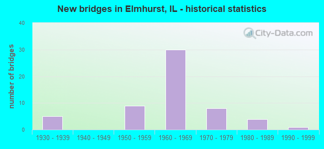
- New bridges - historical statistics
- 51930-1939
- 91950-1959
- 301960-1969
- 81970-1979
- 41980-1989
- 11990-1999
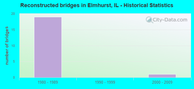
- Reconstructed bridges - Historical Statistics
- 191980-1989
- 01990-1999
- 12000-2009
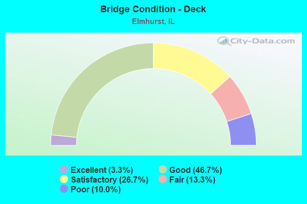
- Bridge Condition - Deck
- 3.3%Excellent
- 46.7%Good
- 26.7%Satisfactory
- 13.3%Fair
- 10.0%Poor
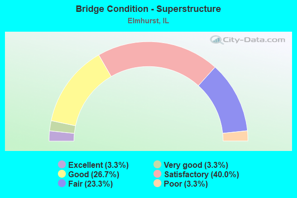
- Bridge Condition - Superstructure
- 3.3%Excellent
- 3.3%Very good
- 26.7%Good
- 40.0%Satisfactory
- 23.3%Fair
- 3.3%Poor
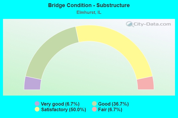
- Bridge Condition - Substructure
- 6.7%Very good
- 36.7%Good
- 50.0%Satisfactory
- 6.7%Fair
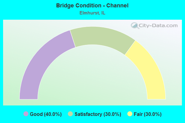
- Bridge Condition - Channel
- 40.0%Good
- 30.0%Satisfactory
- 30.0%Fair
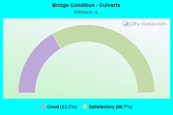
- Bridge Condition - Culverts
- 33.3%Good
- 66.7%Satisfactory
Find on map >> Show street view
Structure Number: 220098, Location: 1.0 M SE OF IL 83 (Lat: 41.925433, Lng: -87.953511), Route carried "under" structure: Other road , Year Built: 1969, Structure Length: 0. m, Average Daily Traffic: 3,700 (year 2020), Truck Traffic: 13%, Features Intersected: CHURCH ST, Facility Carried by Structure: I-290 NB
Minimum Vertical Clearance: 5.00m (16.40ft), Kilometerpoint: 3.959, Lanes on structure: 3, Lanes under structure: 4, Material/Design: Steel continuous, Design/Construction: Stringer/Multi-beam, Length of Maximum Span: 30.8m (101.0ft)
Find on map >> Show street view
Structure Number: 220099, Location: 1.0 M SE OF IL 83 (Lat: 41.925169, Lng: -87.953506), Route carried "under" structure: Other road , Year Built: 1969, Structure Length: 0. m, Average Daily Traffic: 3,700 (year 2020), Truck Traffic: 13%, Features Intersected: CHURCH ST, Facility Carried by Structure: I-290 SB
Minimum Vertical Clearance: 4.50m (14.76ft), Kilometerpoint: 3.975, Lanes on structure: 3, Lanes under structure: 4, Material/Design: Steel continuous, Design/Construction: Stringer/Multi-beam, Length of Maximum Span: 30.8m (101.0ft)
Find on map >> Show street view
Structure Number: 220101, Location: 0.2 M SE OF IL 83 (Lat: 41.927014, Lng: -87.959925), Route carried "under" structure: Other road , Year Built: 1969, Structure Length: 0. m, Average Daily Traffic: 15,000 (year 2020), Truck Traffic: 8%, Features Intersected: GRAND AVE, Facility Carried by Structure: I-290 NB
Minimum Vertical Clearance: 4.72m (15.49ft), Kilometerpoint: 0.579, Lanes on structure: 3, Lanes under structure: 4, Material/Design: Steel continuous, Design/Construction: Stringer/Multi-beam, Length of Maximum Span: 23.1m (75.8ft)
Find on map >> Show street view
Structure Number: 220102, Location: 0.2 M SE OF IL 83 (Lat: 41.926747, Lng: -87.960178), Route carried "under" structure: Other road , Year Built: 1969, Structure Length: 0. m, Average Daily Traffic: 15,000 (year 2020), Truck Traffic: 13%, Features Intersected: GRAND AVE, Facility Carried by Structure: I-290 EB
Minimum Vertical Clearance: 4.65m (15.26ft), Kilometerpoint: 0.547, Lanes on structure: 3, Lanes under structure: 4, Material/Design: Steel continuous, Design/Construction: Stringer/Multi-beam, Length of Maximum Span: 22.2m (72.8ft)
Find on map >> Show street view
Structure Number: 220114, Location: 0.1 M E IL 83 (Lat: 41.860939, Lng: -87.953872), Route carried "under" structure: State highway 38, Year Built: 1965, Structure Length: 0. m, Average Daily Traffic: 49,300 (year 2021), Truck Traffic: 5%, Features Intersected: IL 38, Facility Carried by Structure: IL 56
Minimum Vertical Clearance: 4.75m (15.58ft), Kilometerpoint: 137.579, Lanes on structure: 4, Lanes under structure: 6, Material/Design: Prestressed concrete, Design/Construction: Stringer/Multi-beam, Length of Maximum Span: 17.1m (56.1ft)
Find on map >> Show street view
Structure Number: 22012, Location: 1.25 M N OF IL 64 (Lat: 41.924042, Lng: -87.966369), Route carried "under" structure: Other road , Year Built: 1969, Structure Length: 0. m, Average Daily Traffic: 11,100 (year 2020), Truck Traffic: 38%, Features Intersected: IL 83, Facility Carried by Structure: US 20
Minimum Vertical Clearance: 4.70m (15.42ft), Kilometerpoint: 0.740, Lanes on structure: 4, Lanes under structure: 2, Material/Design: Steel continuous, Design/Construction: Stringer/Multi-beam, Length of Maximum Span: 39.0m (128.0ft)
Find on map >> Show street view
Structure Number: 220149, Location: 0.5 M N OF IL 64 (Lat: 41.909797, Lng: -87.931106), Route carried "under" structure: Interstate 290, Year Built: 1985, Structure Length: 0. m, Average Daily Traffic: 124,400 (year 2021), Truck Traffic: 20%, Features Intersected: I-290, Facility Carried by Structure: EMROY AVE
Minimum Vertical Clearance: 5.26m (17.26ft), Kilometerpoint: 20.921, Lanes on structure: 2, Lanes under structure: 10, Material/Design: Steel continuous, Design/Construction: Stringer/Multi-beam, Length of Maximum Span: 26.4m (86.6ft)
Find on map >> Show street view
Structure Number: 222003, Location: 1.7 M S OF GRAND AVE (Lat: 41.903000, Lng: -87.920428), Route carried "under" structure: Other road , Year Built: 1969, Structure Length: 0. m, Average Daily Traffic: 9,300 (year 2021), Truck Traffic: 20%, Features Intersected: I-290 WB TO US20 EB, Facility Carried by Structure: I-294 SB TO I-290
Minimum Vertical Clearance: 6.10m (20.01ft), Kilometerpoint: 0.467, Lanes on structure: 1, Lanes under structure: 1, Material/Design: Steel, Design/Construction: Stringer/Multi-beam, Length of Maximum Span: 29.3m (96.1ft)
Find on map >> Show street view
Structure Number: 2264, Location: 0.5 MI. S. OF ILL 64 (Lat: 41.899611, Lng: -87.938300), Route carried "under" structure: Other road , Year Built: 1976, Structure Length: 0. m, Average Daily Traffic: 10,800 (year 2020), Truck Traffic: 3%, Features Intersected: PALMER DR, Facility Carried by Structure: PARK ST.
Minimum Vertical Clearance: 4.50m (14.76ft), Kilometerpoint: 6.856, Lanes on structure: 2, Lanes under structure: 4, Material/Design: Steel, Design/Construction: Stringer/Multi-beam, Length of Maximum Span: 23.7m (77.8ft)
Find on map >> Show street view
Structure Number: 226401, Location: 0.5 MI. S. OF ILL 64 (Lat: 41.899381, Lng: -87.938289), Route carried "under" structure: Other road , Year Built: 1976, Structure Length: 0. m, Average Daily Traffic: 10,800 (year 2020), Truck Traffic: 3%, Features Intersected: KENILWORTH AVE, Facility Carried by Structure: C&NW RR
Minimum Vertical Clearance: 4.72m (15.49ft), Kilometerpoint: 6.888, Lanes under structure: 4, Material/Design: Steel, Design/Construction: Girder and Floorbeam System, Length of Maximum Span: 23.8m (78.1ft)
Find on map >> Show street view
Structure Number: 226402, Location: 0.5 MI. S. OF ILL 64 (Lat: 41.899169, Lng: -87.938281), Route carried "under" structure: Other road , Year Built: 1976, Structure Length: 0. m, Average Daily Traffic: 10,800 (year 2020), Truck Traffic: 3%, Features Intersected: PALMER DR, Facility Carried by Structure: FIRST AVE.
Minimum Vertical Clearance: 4.57m (14.99ft), Kilometerpoint: 6.920, Lanes on structure: 2, Lanes under structure: 4, Material/Design: Steel, Design/Construction: Stringer/Multi-beam, Length of Maximum Span: 23.7m (77.8ft)
Find on map >> Show street view
Structure Number: 229934, Location: 1.0 M.N.22ND.ST. (Lat: 41.861811, Lng: -87.925900), Route carried "under" structure: State highway 38, Year Built: 1958, Structure Length: 0. m, Average Daily Traffic: 50,300 (year 2021), Truck Traffic: 8%, Features Intersected: ILL 38 (ROOSEVELT RD, Facility Carried by Structure: I-88 EB
Minimum Vertical Clearance: 4.47m (14.67ft), Kilometerpoint: 139.896, Lanes on structure: 3, Lanes under structure: 6, Toll: On toll road, Material/Design: Prestressed concrete, Design/Construction: Stringer/Multi-beam, Length of Maximum Span: 25.3m (83.0ft)