Bridge Statistics for Fairbanks, Alaska (AK)
Condition, Traffic, Stress, Structural Evaluation, Project Costs
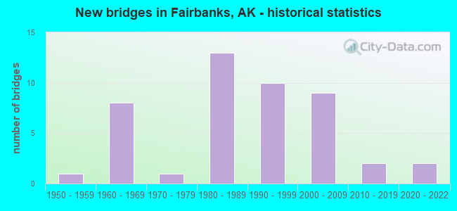
- New bridges - historical statistics
- 11950-1959
- 81960-1969
- 11970-1979
- 131980-1989
- 101990-1999
- 92000-2009
- 22010-2019
- 22020-2022
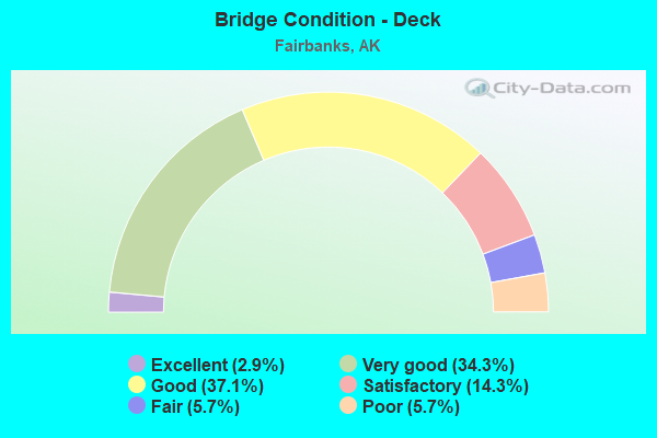
- Bridge Condition - Deck
- 2.9%Excellent
- 34.3%Very good
- 37.1%Good
- 14.3%Satisfactory
- 5.7%Fair
- 5.7%Poor
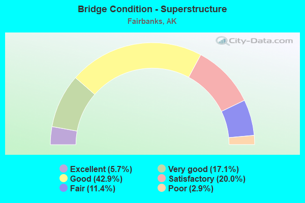
- Bridge Condition - Superstructure
- 5.7%Excellent
- 17.1%Very good
- 42.9%Good
- 20.0%Satisfactory
- 11.4%Fair
- 2.9%Poor
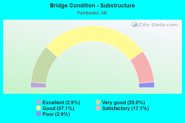
- Bridge Condition - Substructure
- 2.9%Excellent
- 20.0%Very good
- 57.1%Good
- 17.1%Satisfactory
- 2.9%Poor
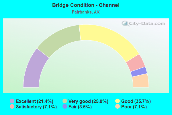
- Bridge Condition - Channel
- 21.4%Excellent
- 25.0%Very good
- 35.7%Good
- 7.1%Satisfactory
- 3.6%Fair
- 7.1%Poor
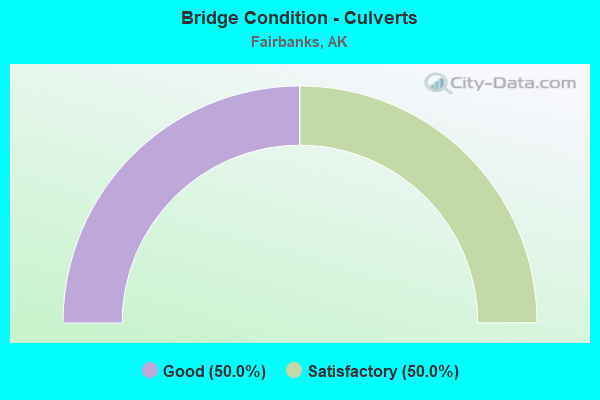
- Bridge Condition - Culverts
- 50.0%Good
- 50.0%Satisfactory
Find on map >> Show street view
Structure Number: 209, Location: MILE POINT 0.2 (Lat: 64.861292, Lng: -147.761344), Route carried "on" structure: State highway 625, Year Built: 1960, Status: Open, Structure Length: 3.03m (9.94ft), Average Daily Traffic: 2,600 (year 2020), Truck Traffic: 13%, Average Future Daily Traffic: 3,330 (year 2039), Design Load: HS 20, Features Intersected: NOYES SLOUGH (AURORA), Facility Carried by Structure: AURORA DRIVE
Minimum Vertical Clearance: 30+ m (98+ ft), Kilometerpoint: 0.322, Lanes on structure: 2, Owner: State Highway Agency, Approaching Roadway Width: 13.7m (44.9ft), Skew: 3 degrees, Material/Design: Steel, Design/Construction: Stringer/Multi-beam, Number Of Spans In Main Unit: 2, Length of Maximum Span: 15.2m (49.9ft), Curb or Sidewalk Widths: Left: 0.9m (3.0ft), Right: 0.9m (3.0ft), Curb-To-Curb Width: 9.1m (29.9ft), Out-to-Out Width: 11.0m (36.1ft)
Condition: Deck: Poor, Superstructure: Good, Substructure: Satisfactory, Channel: Poor, Operating Rating: 82.0 metric tons, Method Used To Determine Operating Rating: Load Factor (LF), Inventory Rating: 37.7 metric tons, Method Used To Determine Inventory Rating: Load Factor (LF), Structural Evaluation: Equal to present minimum criteria, Deck Geometry: Meets minimum limits, Waterway Adequacy: Better than present minimum criteria, Approach Roadway Alignment: High priority of corrective action, Designated Inspection Frequency: Every 24 months, Inspection Date: August 2020, Deck Structure Type: Concrete Cast-file-Place, Wearing Surface/Protective System: Wearing Surface: Monolithic Concrete
Find on map >> Show street view
Structure Number: 283, Location: MILE POINT 2.2 (Lat: 64.853931, Lng: -147.716336), Route carried "on" structure: State highway 663, Year Built: 2013, Status: Open, Structure Length: 3.65m (11.98ft), Average Daily Traffic: 10,400 (year 2020), Truck Traffic: 5%, Average Future Daily Traffic: 15,700 (year 2039), Design Load: HL 93, Features Intersected: NOYES SLOUGH (ILLINOIS), Facility Carried by Structure: ILLINOIS STREET
Minimum Vertical Clearance: 30+ m (98+ ft), Kilometerpoint: 3.541, Lanes on structure: 4, Owner: State Highway Agency, Approaching Roadway Width: 15.8m (51.8ft), Skew: 21 degrees, Material/Design: Prestressed concrete, Design/Construction: Tee Beam, Number Of Spans In Main Unit: 1, Length of Maximum Span: 34.7m (113.8ft), Curb or Sidewalk Widths: Left: 2.7m (8.9ft), Right: 3.3m (10.8ft), Curb-To-Curb Width: 20.7m (67.9ft), Out-to-Out Width: 25.6m (84.0ft)
Condition: Deck: Very good, Superstructure: Very good, Substructure: Very good, Channel: Excellent, Operating Rating: 87.7 metric tons, Method Used To Determine Operating Rating: Load Factor (LF), Inventory Rating: 40.4 metric tons, Method Used To Determine Inventory Rating: Load Factor (LF), Structural Evaluation: Equal to present desirable criteria, Deck Geometry: Superior to present desirable criteria, Waterway Adequacy: Equal to present desirable criteria, Approach Roadway Alignment: Equal to present minimum criteria, Designated Inspection Frequency: Every 24 months, Inspection Date: August 2020, Deck Structure Type: Other, Wearing Surface/Protective System: Wearing Surface: Bituminous, Membrane: Preformed Fabric, Deck Protection: Epoxy Coated Reinforcing
Find on map >> Show street view
Structure Number: 295, Location: MILE POINT 0.4 (Lat: 64.848747, Lng: -147.706989), Route carried "on" structure: State highway 670, Year Built: 1953, Status: Open, Structure Length: 4.12m (13.52ft), Average Daily Traffic: 4,130 (year 2020), Truck Traffic: 5%, Average Future Daily Traffic: 5,280 (year 2039), Design Load: HS 20+Mod, Features Intersected: NOYES SLOUGH (MINNIE ST), Facility Carried by Structure: MINNIE STREET
Minimum Vertical Clearance: 30+ m (98+ ft), Kilometerpoint: 0.644, Lanes on structure: 2, Owner: State Highway Agency, Approaching Roadway Width: 9.1m (29.9ft), Material/Design: Steel, Design/Construction: Stringer/Multi-beam, Number Of Spans In Main Unit: 3, Length of Maximum Span: 13.2m (43.3ft), Curb or Sidewalk Widths: Left: 1.5m (4.9ft), Right: 1.5m (4.9ft), Curb-To-Curb Width: 9.1m (29.9ft), Out-to-Out Width: 9.6m (31.5ft)
Condition: Deck: Satisfactory, Superstructure: Fair, Substructure: Poor, Channel: Poor, Operating Rating: 53.9 metric tons, Method Used To Determine Operating Rating: Load Factor (LF), Inventory Rating: 24.9 metric tons, Method Used To Determine Inventory Rating: Load Factor (LF), Structural Evaluation: Meets minimum limits, Deck Geometry: Meets minimum limits, Waterway Adequacy: Better than present minimum criteria, Approach Roadway Alignment: Equal to present minimum criteria, Designated Inspection Frequency: Every 24 months, Inspection Date: August 2020, Deck Structure Type: Concrete Cast-file-Place, Wearing Surface/Protective System: Wearing Surface: Monolithic Concrete
Find on map >> Show street view
Structure Number: 392, Location: MILE POINT 37.3 (Lat: 65.191756, Lng: -147.254933), Route carried "on" structure: State highway 670, Year Built: 1967, Status: Open, Structure Length: 9.67m (31.73ft), Average Daily Traffic: 210 (year 2020), Truck Traffic: 17%, Average Future Daily Traffic: 710 (year 2039), Design Load: HS 20+Mod, Features Intersected: CHATANIKA RIVER, Facility Carried by Structure: STEESE HIGHWAY
Minimum Vertical Clearance: 4.24m (13.91ft), Kilometerpoint: 60.077, Lanes on structure: 2, Base Highway Network: Yes, Owner: State Highway Agency, Approaching Roadway Width: 8.7m (28.5ft), Skew: 2 degrees, Material/Design: Steel continuous, Design/Construction: Stringer/Multi-beam, Number Of Spans In Main Unit: 3, Length of Maximum Span: 36.6m (120.1ft), Curb or Sidewalk Widths: Left: 0.5m (1.6ft), Right: 0.5m (1.6ft), Curb-To-Curb Width: 9.1m (29.9ft), Out-to-Out Width: 10.1m (33.1ft)
Condition: Deck: Good, Superstructure: Good, Substructure: Very good, Channel: Good, Operating Rating: 58.7 metric tons, Method Used To Determine Operating Rating: Load Factor (LF), Inventory Rating: 35.1 metric tons, Method Used To Determine Inventory Rating: Load Factor (LF), Structural Evaluation: Better than present minimum criteria, Deck Geometry: Equal to present minimum criteria, Waterway Adequacy: Equal to present desirable criteria, Approach Roadway Alignment: Equal to present desirable criteria, Designated Inspection Frequency: Every 24 months, Inspection Date: August 2020, Deck Structure Type: Concrete Cast-file-Place, Wearing Surface/Protective System: Wearing Surface: Monolithic Concrete
Find on map >> Show street view
Structure Number: 408, Location: MILE POINT 10.0 (Lat: 60.505861, Lng: -145.530050), Route carried "on" structure: State highway 851, Year Built: 1966, Status: Open, Structure Length: 4.93m (16.17ft), Average Daily Traffic: 520 (year 2020), Truck Traffic: 17%, Average Future Daily Traffic: 630 (year 2039), Design Load: HS 20+Mod, Features Intersected: SCOTT GLACIER NO 8, Facility Carried by Structure: COPPER RIVER HWY
Minimum Vertical Clearance: 6.10m (20.01ft), Kilometerpoint: 16.048, Lanes on structure: 2, Owner: State Highway Agency, Approaching Roadway Width: 7.6m (24.9ft), Material/Design: Steel, Design/Construction: Stringer/Multi-beam, Number Of Spans In Main Unit: 3, Length of Maximum Span: 18.3m (60.0ft), Curb-To-Curb Width: 8.6m (28.2ft), Out-to-Out Width: 9.0m (29.5ft)
Condition: Deck: Satisfactory, Superstructure: Satisfactory, Substructure: Satisfactory, Channel: Very good, Operating Rating: 63.0 metric tons, Method Used To Determine Operating Rating: Load Factor (LF), Inventory Rating: 29.0 metric tons, Method Used To Determine Inventory Rating: Load Factor (LF), Structural Evaluation: Equal to present minimum criteria, Deck Geometry: Somewhat better than minimum adequacy, Waterway Adequacy: Equal to present minimum criteria, Approach Roadway Alignment: Equal to present desirable criteria, Designated Inspection Frequency: Every 24 months, Inspection Date: August 2020, Deck Structure Type: Concrete Cast-file-Place, Wearing Surface/Protective System: Wearing Surface: Monolithic Concrete
Find on map >> Show street view
Structure Number: 43, Location: MILE POINT 66.0 (Lat: 65.290400, Lng: -146.382583), Route carried "on" structure: State highway 670, Year Built: 1983, Status: Open, Structure Length: 2.44m (8.01ft), Average Daily Traffic: 100 (year 2020), Truck Traffic: 13%, Average Future Daily Traffic: 140 (year 2039), Design Load: HS 20, Features Intersected: FAITH CREEK, Facility Carried by Structure: STEESE HIGHWAY
Minimum Vertical Clearance: 4.24m (13.91ft), Kilometerpoint: 106.212, Lanes on structure: 2, Base Highway Network: Yes, Owner: State Highway Agency, Approaching Roadway Width: 8.8m (28.9ft), Material/Design: Wood or Timber, Design/Construction: Stringer/Multi-beam, Number Of Spans In Main Unit: 1, Length of Maximum Span: 19.5m (64.0ft), Curb-To-Curb Width: 8.5m (27.9ft), Out-to-Out Width: 8.8m (28.9ft)
Condition: Deck: Very good, Superstructure: Good, Substructure: Good, Channel: Excellent, Operating Rating: 84.8 metric tons, Method Used To Determine Operating Rating: Load Factor (LF), Inventory Rating: 49.2 metric tons, Method Used To Determine Inventory Rating: Load Factor (LF), Structural Evaluation: Better than present minimum criteria, Deck Geometry: Better than present minimum criteria, Waterway Adequacy: Equal to present desirable criteria, Approach Roadway Alignment: Equal to present desirable criteria, Designated Inspection Frequency: Every 24 months, Inspection Date: August 2020, Deck Structure Type: Wood or Timber, Wearing Surface/Protective System: Wearing Surface: Wood or Timber
Find on map >> Show street view
Structure Number: 532, Location: MILE POINT 1.2 (Lat: 64.846289, Lng: -147.708631), Route carried "on" structure: State highway 671, Year Built: 2021, Status: Open, Structure Length: 10.21m (33.50ft), Average Daily Traffic: 6,250 (year 2020), Truck Traffic: 6%, Average Future Daily Traffic: 7,910 (year 2039), Design Load: HL 93, Features Intersected: CHENA RIVER (WENDELL), Facility Carried by Structure: WENDELL AVENUE
Minimum Vertical Clearance: 30+ m (98+ ft), Kilometerpoint: 1.880, Lanes on structure: 2, Owner: State Highway Agency, Approaching Roadway Width: 11.0m (36.1ft), Navigation Control: Yes ( Vertical Clearance: 2.7m (8.9ft), Horizontal Clearance: 32.6m (107.0ft)), Material/Design: Prestressed concrete, Design/Construction: Tee Beam, Number Of Spans In Main Unit: 3, Length of Maximum Span: 33.1m (108.6ft), Curb or Sidewalk Widths: Left: 2.5m (8.2ft), Right: 2.5m (8.2ft), Curb-To-Curb Width: 11.0m (36.1ft), Out-to-Out Width: 16.7m (54.8ft)
Condition: Deck: Excellent, Superstructure: Excellent, Substructure: Excellent, Channel: Very good, Operating Rating: 87.7 metric tons, Method Used To Determine Operating Rating: Load Factor (LF), Inventory Rating: 40.4 metric tons, Method Used To Determine Inventory Rating: Load Factor (LF), Structural Evaluation: Superior to present desirable criteria, Deck Geometry: Meets minimum limits, Waterway Adequacy: Equal to present desirable criteria, Approach Roadway Alignment: Superior to present desirable criteria, Designated Inspection Frequency: Every 24 months, Inspection Date: September 2021, Deck Structure Type: Other, Wearing Surface/Protective System: Wearing Surface: Bituminous, Membrane: Other, Deck Protection: Epoxy Coated Reinforcing
Find on map >> Show street view
Structure Number: 799, Location: MILE POINT 43.7 (Lat: 65.219892, Lng: -147.075994), Route carried "on" structure: State highway 670, Year Built: 1980, Status: Open, Structure Length: 0.98m (3.22ft), Average Daily Traffic: 120 (year 2020), Truck Traffic: 13%, Average Future Daily Traffic: 140 (year 2039), Design Load: HS 20+Mod, Features Intersected: LONG CREEK, Facility Carried by Structure: STEESE HIGHWAY
Minimum Vertical Clearance: 4.24m (13.91ft), Kilometerpoint: 70.333, Lanes on structure: 2, Base Highway Network: Yes, Owner: State Highway Agency, Approaching Roadway Width: 8.5m (27.9ft), Material/Design: Wood or Timber, Design/Construction: Stringer/Multi-beam, Number Of Spans In Main Unit: 1, Length of Maximum Span: 9.8m (32.2ft), Curb-To-Curb Width: 8.5m (27.9ft), Out-to-Out Width: 8.8m (28.9ft)
Condition: Deck: Very good, Superstructure: Very good, Substructure: Satisfactory, Channel: Very good, Operating Rating: 62.9 metric tons, Method Used To Determine Operating Rating: Load Factor (LF), Inventory Rating: 37.1 metric tons, Method Used To Determine Inventory Rating: Load Factor (LF), Structural Evaluation: Equal to present minimum criteria, Deck Geometry: Equal to present minimum criteria, Waterway Adequacy: Equal to present desirable criteria, Approach Roadway Alignment: Equal to present minimum criteria, Designated Inspection Frequency: Every 24 months, Inspection Date: August 2020, Deck Structure Type: Wood or Timber, Wearing Surface/Protective System: Wearing Surface: Wood or Timber
Find on map >> Show street view
Structure Number: 816, Location: MILE POINT 38.8 (Lat: 65.204467, Lng: -147.227086), Route carried "on" structure: State highway 670, Year Built: 1967, Status: Open, Structure Length: 1.69m (5.54ft), Average Daily Traffic: 120 (year 2020), Truck Traffic: 13%, Average Future Daily Traffic: 140 (year 2039), Design Load: HS 20+Mod, Features Intersected: CROOKED CREEK, Facility Carried by Structure: STEESE HIGHWAY
Minimum Vertical Clearance: 4.24m (13.91ft), Kilometerpoint: 62.381, Lanes on structure: 2, Base Highway Network: Yes, Owner: State Highway Agency, Approaching Roadway Width: 9.4m (30.8ft), Material/Design: Steel, Design/Construction: Stringer/Multi-beam, Number Of Spans In Main Unit: 1, Length of Maximum Span: 16.5m (54.1ft), Curb-To-Curb Width: 9.4m (30.8ft), Out-to-Out Width: 9.9m (32.5ft)
Condition: Deck: Good, Superstructure: Very good, Substructure: Good, Channel: Very good, Operating Rating: 65.0 metric tons, Method Used To Determine Operating Rating: Load Factor (LF), Inventory Rating: 30.0 metric tons, Method Used To Determine Inventory Rating: Load Factor (LF), Structural Evaluation: Better than present minimum criteria, Deck Geometry: Equal to present minimum criteria, Waterway Adequacy: Equal to present desirable criteria, Approach Roadway Alignment: Equal to present desirable criteria, Designated Inspection Frequency: Every 24 months, Inspection Date: August 2020, Deck Structure Type: Concrete Cast-file-Place, Wearing Surface/Protective System: Wearing Surface: Monolithic Concrete
Find on map >> Show street view
Structure Number: 821, Location: MILE POINT 35.8 (Lat: 65.174292, Lng: -147.284153), Route carried "on" structure: State highway 670, Year Built: 1967, Status: Open, Structure Length: 1.55m (5.09ft), Average Daily Traffic: 210 (year 2020), Truck Traffic: 17%, Average Future Daily Traffic: 710 (year 2039), Design Load: HS 20+Mod, Features Intersected: KOKOMO CREEK, Facility Carried by Structure: STEESE HIGHWAY
Minimum Vertical Clearance: 4.24m (13.91ft), Kilometerpoint: 57.629, Lanes on structure: 2, Base Highway Network: Yes, Owner: State Highway Agency, Approaching Roadway Width: 10.7m (35.1ft), Skew: 3 degrees, Material/Design: Steel, Design/Construction: Stringer/Multi-beam, Number Of Spans In Main Unit: 1, Length of Maximum Span: 14.9m (48.9ft), Curb-To-Curb Width: 9.4m (30.8ft), Out-to-Out Width: 9.9m (32.5ft)
Condition: Deck: Good, Superstructure: Good, Substructure: Very good, Channel: Very good, Operating Rating: 65.0 metric tons, Method Used To Determine Operating Rating: Load Factor (LF), Inventory Rating: 30.0 metric tons, Method Used To Determine Inventory Rating: Load Factor (LF), Structural Evaluation: Better than present minimum criteria, Deck Geometry: Equal to present minimum criteria, Waterway Adequacy: Equal to present minimum criteria, Approach Roadway Alignment: Equal to present desirable criteria, Designated Inspection Frequency: Every 24 months, Inspection Date: August 2020, Deck Structure Type: Concrete Cast-file-Place, Wearing Surface/Protective System: Wearing Surface: Monolithic Concrete
Find on map >> Show street view
Structure Number: 822, Location: MILE POINT 39.8 (Lat: 65.212683, Lng: -147.197097), Route carried "on" structure: State highway 670, Year Built: 1967, Status: Open, Structure Length: 3.06m (10.04ft), Average Daily Traffic: 120 (year 2020), Truck Traffic: 13%, Average Future Daily Traffic: 140 (year 2039), Design Load: HS 20+Mod, Features Intersected: BELLE CREEK, Facility Carried by Structure: STEESE HIGHWAY
Minimum Vertical Clearance: 4.24m (13.91ft), Kilometerpoint: 64.092, Lanes on structure: 2, Base Highway Network: Yes, Owner: State Highway Agency, Approaching Roadway Width: 9.4m (30.8ft), Material/Design: Steel, Design/Construction: Stringer/Multi-beam, Number Of Spans In Main Unit: 2, Length of Maximum Span: 15.3m (50.2ft), Curb-To-Curb Width: 9.4m (30.8ft), Out-to-Out Width: 9.9m (32.5ft)
Condition: Deck: Good, Superstructure: Very good, Substructure: Good, Channel: Good, Operating Rating: 65.0 metric tons, Method Used To Determine Operating Rating: Load Factor (LF), Inventory Rating: 30.0 metric tons, Method Used To Determine Inventory Rating: Load Factor (LF), Structural Evaluation: Better than present minimum criteria, Deck Geometry: Equal to present minimum criteria, Waterway Adequacy: Equal to present desirable criteria, Approach Roadway Alignment: Equal to present desirable criteria, Designated Inspection Frequency: Every 24 months, Inspection Date: August 2020, Deck Structure Type: Concrete Cast-file-Place, Wearing Surface/Protective System: Wearing Surface: Monolithic Concrete
Find on map >> Show street view
Structure Number: 823, Location: MILE POINT 41.0 (Lat: 65.221350, Lng: -147.162342), Route carried "on" structure: State highway 670, Year Built: 1967, Status: Open, Structure Length: 3.37m (11.06ft), Average Daily Traffic: 120 (year 2020), Truck Traffic: 13%, Average Future Daily Traffic: 140 (year 2039), Design Load: HS 20+Mod, Features Intersected: MCKAY CREEK, Facility Carried by Structure: STEESE HIGHWAY
Minimum Vertical Clearance: 4.24m (13.91ft), Kilometerpoint: 66.022, Lanes on structure: 2, Base Highway Network: Yes, Owner: State Highway Agency, Approaching Roadway Width: 9.4m (30.8ft), Skew: 1 degrees, Material/Design: Steel, Design/Construction: Stringer/Multi-beam, Number Of Spans In Main Unit: 2, Length of Maximum Span: 16.8m (55.1ft), Curb-To-Curb Width: 9.4m (30.8ft), Out-to-Out Width: 9.9m (32.5ft)
Condition: Deck: Good, Superstructure: Very good, Substructure: Good, Channel: Very good, Operating Rating: 65.0 metric tons, Method Used To Determine Operating Rating: Load Factor (LF), Inventory Rating: 30.0 metric tons, Method Used To Determine Inventory Rating: Load Factor (LF), Structural Evaluation: Better than present minimum criteria, Deck Geometry: Equal to present minimum criteria, Waterway Adequacy: Equal to present desirable criteria, Approach Roadway Alignment: Equal to present desirable criteria, Designated Inspection Frequency: Every 24 months, Inspection Date: August 2020, Deck Structure Type: Concrete Cast-file-Place, Wearing Surface/Protective System: Wearing Surface: Monolithic Concrete
Find on map >> Show street view
Structure Number: 825, Location: MILE POINT 62.8 (Lat: 65.289831, Lng: -146.480236), Route carried "on" structure: State highway 670, Year Built: 1983, Status: Open, Structure Length: 1.35m (4.43ft), Average Daily Traffic: 120 (year 2020), Truck Traffic: 13%, Average Future Daily Traffic: 140 (year 2039), Design Load: HS 20+Mod, Features Intersected: SOURDOUGH CREEK, Facility Carried by Structure: STEESE HIGHWAY
Minimum Vertical Clearance: 4.24m (13.91ft), Kilometerpoint: 101.033, Lanes on structure: 2, Base Highway Network: Yes, Owner: State Highway Agency, Approaching Roadway Width: 8.8m (28.9ft), Material/Design: Wood or Timber, Design/Construction: Stringer/Multi-beam, Number Of Spans In Main Unit: 1, Length of Maximum Span: 12.8m (42.0ft), Curb-To-Curb Width: 8.8m (28.9ft), Out-to-Out Width: 9.1m (29.9ft)
Condition: Deck: Very good, Superstructure: Very good, Substructure: Good, Channel: Satisfactory, Operating Rating: 60.8 metric tons, Method Used To Determine Operating Rating: Load Factor (LF), Inventory Rating: 35.8 metric tons, Method Used To Determine Inventory Rating: Load Factor (LF), Structural Evaluation: Better than present minimum criteria, Deck Geometry: Equal to present minimum criteria, Waterway Adequacy: Equal to present desirable criteria, Approach Roadway Alignment: Equal to present desirable criteria, Designated Inspection Frequency: Every 24 months, Inspection Date: August 2020, Deck Structure Type: Wood or Timber, Wearing Surface/Protective System: Wearing Surface: Wood or Timber
Find on map >> Show street view
Structure Number: 1191, Location: MILE POINT 0.5 (Lat: 64.842614, Lng: -147.778564), Route carried "on" structure: State highway 625, Year Built: 1977, Status: Open, Structure Length: 7.85m (25.75ft), Average Daily Traffic: 14,900 (year 2020), Truck Traffic: 6%, Average Future Daily Traffic: 14,800 (year 2039), Design Load: HS 25 or greater, Features Intersected: CHENA RIVER (PEGER RD), Facility Carried by Structure: PEGER ROAD
Minimum Vertical Clearance: 30+ m (98+ ft), Kilometerpoint: 0.845, Lanes on structure: 4, Owner: State Highway Agency, Approaching Roadway Width: 18.3m (60.0ft), Skew: 2 degrees, Navigation Control: Yes ( Vertical Clearance: 2.7m (8.9ft), Horizontal Clearance: 24.6m (80.7ft)), Material/Design: Prestressed concrete, Design/Construction: Tee Beam, Number Of Spans In Main Unit: 3, Length of Maximum Span: 25.3m (83.0ft), Curb or Sidewalk Widths: Left: 0.0m, Right: 2.1m (6.9ft), Curb-To-Curb Width: 18.3m (60.0ft), Out-to-Out Width: 21.4m (70.2ft)
Condition: Deck: Satisfactory, Superstructure: Satisfactory, Substructure: Satisfactory, Channel: Good, Operating Rating: 67.9 metric tons, Method Used To Determine Operating Rating: Load Factor (LF), Inventory Rating: 25.8 metric tons, Method Used To Determine Inventory Rating: Load Factor (LF), Structural Evaluation: Equal to present minimum criteria, Deck Geometry: Somewhat better than minimum adequacy, Waterway Adequacy: Equal to present minimum criteria, Approach Roadway Alignment: Equal to present desirable criteria, Designated Inspection Frequency: Every 24 months, Underwater Inspection Frequency: Every 60 months, Inspection Date: August 2020, Underwater Inspection Date: September 2020, Deck Structure Type: Other, Wearing Surface/Protective System: Wearing Surface: Bituminous, Membrane: Preformed Fabric
Find on map >> Show street view
Structure Number: 1448, Location: MILE POINT 0.7 (Lat: 64.860997, Lng: -147.744069), Route carried "on" structure: ServiceCity street NSPCY, Year Built: 1989, Status: Open, Structure Length: 2.29m (7.51ft), Average Daily Traffic: 1,980 (year 2020), Truck Traffic: 5%, Average Future Daily Traffic: 3,730 (year 2039), Design Load: HS 25 or greater, Features Intersected: NOYES SLOUGH, Facility Carried by Structure: DANBY ROAD
Minimum Vertical Clearance: 30+ m (98+ ft), Kilometerpoint: 1.178, Lanes on structure: 3, Owner: State Highway Agency, Approaching Roadway Width: 15.8m (51.8ft), Material/Design: Prestressed concrete, Design/Construction: Tee Beam, Number Of Spans In Main Unit: 1, Length of Maximum Span: 22.4m (73.5ft), Curb or Sidewalk Widths: Left: 0.0m, Right: 2.7m (8.9ft), Curb-To-Curb Width: 15.8m (51.8ft), Out-to-Out Width: 19.6m (64.3ft)
Condition: Deck: Satisfactory, Superstructure: Good, Substructure: Good, Channel: Good, Operating Rating: 85.9 metric tons, Method Used To Determine Operating Rating: Load Factor (LF), Inventory Rating: 38.6 metric tons, Method Used To Determine Inventory Rating: Load Factor (LF), Structural Evaluation: Better than present minimum criteria, Deck Geometry: Better than present minimum criteria, Waterway Adequacy: Equal to present desirable criteria, Approach Roadway Alignment: Equal to present desirable criteria, Designated Inspection Frequency: Every 24 months, Inspection Date: August 2020, Deck Structure Type: Other, Wearing Surface/Protective System: Wearing Surface: Bituminous, Deck Protection: Epoxy Coated Reinforcing
Find on map >> Show street view
Structure Number: 1697, Location: MILE POINT 1.4 (Lat: 64.849919, Lng: -147.762400), Route carried "on" structure: State highway 668, Year Built: 1989, Status: Open, Structure Length: 8.53m (27.99ft), Average Daily Traffic: 18,300 (year 2020), Truck Traffic: 7%, Average Future Daily Traffic: 23,400 (year 2039), Design Load: HS 25 or greater, Features Intersected: GEIST ROAD OVERHEAD, Facility Carried by Structure: JOHANSEN EXPRESSWY
Minimum Vertical Clearance: 5.33m (17.49ft), Kilometerpoint: 2.322, Lanes on structure: 5, Base Highway Network: Yes, Owner: State Highway Agency, Approaching Roadway Width: 21.6m (70.9ft), Skew: 36 degrees, Material/Design: Prestressed concrete, Design/Construction: Tee Beam, Number Of Spans In Main Unit: 2, Length of Maximum Span: 44.3m (145.3ft), Curb or Sidewalk Widths: Left: 0.0m, Right: 3.7m (12.1ft), Curb-To-Curb Width: 30.2m (99.1ft), Out-to-Out Width: 35.1m (115.2ft)
Condition: Deck: Good, Superstructure: Satisfactory, Substructure: Good, Operating Rating: 87.7 metric tons, Method Used To Determine Operating Rating: Load Factor (LF), Inventory Rating: 31.8 metric tons, Method Used To Determine Inventory Rating: Load Factor (LF), Structural Evaluation: Equal to present minimum criteria, Deck Geometry: Superior to present desirable criteria, Underclear: Equal to present desirable criteria, Approach Roadway Alignment: Equal to present desirable criteria, Designated Inspection Frequency: Every 24 months, Inspection Date: August 2020, Deck Structure Type: Other, Wearing Surface/Protective System: Wearing Surface: Bituminous, Deck Protection: Epoxy Coated Reinforcing
Find on map >> Show street view
Structure Number: 1705, Location: MILE POINT 323.7 (Lat: 64.820450, Lng: -147.710983), Route carried "on" structure: Interstate A21, Year Built: 1988, Status: Open, Structure Length: 3.24m (10.63ft), Average Daily Traffic: 13,700 (year 2020), Truck Traffic: 8%, Average Future Daily Traffic: 17,500 (year 2039), Design Load: HS 20, Features Intersected: CUSHMAN ST UC, Facility Carried by Structure: PARKS HIGHWAY
Minimum Vertical Clearance: 5.42m (17.78ft), Kilometerpoint: 520.906, Lanes on structure: 4, Lanes under structure: 3, Base Highway Network: Yes, Owner: State Highway Agency, Approaching Roadway Width: 23.2m (76.1ft), Skew: 10 degrees, Material/Design: Prestressed concrete, Design/Construction: Tee Beam, Number Of Spans In Main Unit: 1, Length of Maximum Span: 31.6m (103.7ft), Curb-To-Curb Width: 21.9m (71.9ft), Out-to-Out Width: 23.4m (76.8ft)
Condition: Deck: Very good, Superstructure: Poor, Substructure: Very good, Operating Rating: 84.2 metric tons, Method Used To Determine Operating Rating: Load Factor (LF), Inventory Rating: 37.6 metric tons, Method Used To Determine Inventory Rating: Load Factor (LF), Structural Evaluation: Meets minimum limits, Deck Geometry: Better than present minimum criteria, Underclear: Somewhat better than minimum adequacy, Approach Roadway Alignment: Equal to present desirable criteria, Designated Inspection Frequency: Every 24 months, Inspection Date: July 2020, Deck Structure Type: Other, Wearing Surface/Protective System: Wearing Surface: Bituminous, Membrane: Preformed Fabric, Deck Protection: Epoxy Coated Reinforcing
Find on map >> Show street view
Structure Number: 1706, Location: FAIRBANKS (Lat: 64.823300, Lng: -147.709731), Route carried "on" structure: Ramp City street , Year Built: 1988, Status: Open, Structure Length: 4.91m (16.11ft), Average Daily Traffic: 1,720 (year 2020), Truck Traffic: 7%, Average Future Daily Traffic: 2,050 (year 2039), Design Load: HS 20, Features Intersected: C-N RAMP OC, Facility Carried by Structure: CUSHMAN - AK HWY
Minimum Vertical Clearance: 30+ m (98+ ft), Kilometerpoint: 0.357, Lanes on structure: 1, Lanes under structure: 4, Owner: State Highway Agency, Approaching Roadway Width: 6.7m (22.0ft), Skew: 10 degrees, Material/Design: Prestressed concrete, Design/Construction: Tee Beam, Number Of Spans In Main Unit: 2, Length of Maximum Span: 24.2m (79.4ft), Curb-To-Curb Width: 6.7m (22.0ft), Out-to-Out Width: 7.5m (24.6ft)
Condition: Deck: Very good, Superstructure: Satisfactory, Substructure: Good, Inventory Rating: 52.0 metric tons, Method Used To Determine Inventory Rating: Load Factor (LF), Structural Evaluation: Equal to present minimum criteria, Deck Geometry: Equal to present minimum criteria, Underclear: Meets minimum limits, Approach Roadway Alignment: Equal to present desirable criteria, Designated Inspection Frequency: Every 24 months, Inspection Date: August 2020, Deck Structure Type: Other, Wearing Surface/Protective System: Wearing Surface: Bituminous
Find on map >> Show street view
Structure Number: 1707, Location: MILE POINT 0.4 (Lat: 64.821078, Lng: -147.705447), Route carried "on" structure: Ramp State highway A21, Year Built: 1988, Status: Open, Structure Length: 5.34m (17.52ft), Average Daily Traffic: 4,510 (year 2020), Truck Traffic: 7%, Average Future Daily Traffic: 5,380 (year 2039), Design Load: HS 20, Features Intersected: W-W RAMP OC, Facility Carried by Structure: AK HWY-PARKS RAMP
Minimum Vertical Clearance: 5.42m (17.78ft), Kilometerpoint: 0.660, Lanes on structure: 1, Lanes under structure: 4, Base Highway Network: Yes, Owner: State Highway Agency, Approaching Roadway Width: 6.7m (22.0ft), Skew: 10 degrees, Material/Design: Prestressed concrete, Design/Construction: Tee Beam, Number Of Spans In Main Unit: 2, Length of Maximum Span: 28.3m (92.8ft), Curb-To-Curb Width: 6.7m (22.0ft), Out-to-Out Width: 7.5m (24.6ft)
Condition: Deck: Very good, Superstructure: Satisfactory, Substructure: Very good, Operating Rating: 87.7 metric tons, Method Used To Determine Operating Rating: Load Factor (LF), Inventory Rating: 40.4 metric tons, Method Used To Determine Inventory Rating: Load Factor (LF), Structural Evaluation: Equal to present minimum criteria, Deck Geometry: Equal to present minimum criteria, Underclear: Meets minimum limits, Approach Roadway Alignment: Equal to present desirable criteria, Designated Inspection Frequency: Every 24 months, Inspection Date: July 2020, Deck Structure Type: Other, Wearing Surface/Protective System: Wearing Surface: Bituminous, Membrane: Preformed Fabric, Deck Protection: Epoxy Coated Reinforcing
Find on map >> Show street view
Structure Number: 1766, Location: MILE POINT 2.9 (Lat: 64.855833, Lng: -147.718308), Route carried "on" structure: State highway 668, Year Built: 1991, Status: Open, Structure Length: 3.22m (10.56ft), Average Daily Traffic: 13,800 (year 2020), Truck Traffic: 3%, Average Future Daily Traffic: 17,700 (year 2039), Design Load: HS 25 or greater, Features Intersected: NOYES SLOUGH (GEIST RD), Facility Carried by Structure: JOHANSEN EXPRESSWY
Minimum Vertical Clearance: 5.33m (17.49ft), Kilometerpoint: 4.627, Lanes on structure: 4, Base Highway Network: Yes, Owner: State Highway Agency, Approaching Roadway Width: 23.2m (76.1ft), Skew: 34 degrees, Material/Design: Prestressed concrete, Design/Construction: Tee Beam, Number Of Spans In Main Unit: 1, Length of Maximum Span: 31.5m (103.3ft), Curb-To-Curb Width: 23.2m (76.1ft), Out-to-Out Width: 24.5m (80.4ft)
Condition: Deck: Very good, Superstructure: Good, Substructure: Satisfactory, Channel: Excellent, Operating Rating: 87.7 metric tons, Method Used To Determine Operating Rating: Load Factor (LF), Inventory Rating: 36.5 metric tons, Method Used To Determine Inventory Rating: Load Factor (LF), Structural Evaluation: Equal to present minimum criteria, Deck Geometry: Superior to present desirable criteria, Waterway Adequacy: Superior to present desirable criteria, Approach Roadway Alignment: Equal to present desirable criteria, Designated Inspection Frequency: Every 24 months, Inspection Date: August 2020, Deck Structure Type: Other, Wearing Surface/Protective System: Wearing Surface: Bituminous, Membrane: Preformed Fabric, Deck Protection: Epoxy Coated Reinforcing
Find on map >> Show street view
Structure Number: 1792, Location: MILE POINT 0.0 (Lat: 64.844236, Lng: -147.723553), Route carried "on" structure: City street , Year Built: 2010, Status: Open, Structure Length: 6.10m (20.01ft), Average Daily Traffic: 6,850 (year 2020), Truck Traffic: 4%, Average Future Daily Traffic: 24,700 (year 2039), Design Load: HL 93, Features Intersected: CHENA RIVER BARNETTE ST, Facility Carried by Structure: BARNETTE STREET
Minimum Vertical Clearance: 30+ m (98+ ft), Kilometerpoint: 0.000, Lanes on structure: 3, Owner: State Highway Agency, Maintenance Responsibility: City or Municipal Highway Agency, Approaching Roadway Width: 12.2m (40.0ft), Material/Design: Prestressed concrete, Design/Construction: Tee Beam, Number Of Spans In Main Unit: 2, Length of Maximum Span: 32.1m (105.3ft), Curb or Sidewalk Widths: Left: 2.6m (8.5ft), Right: 2.6m (8.5ft), Curb-To-Curb Width: 11.9m (39.0ft), Out-to-Out Width: 17.5m (57.4ft)
Condition: Deck: Very good, Superstructure: Excellent, Substructure: Very good, Channel: Very good, Operating Rating: 87.7 metric tons, Method Used To Determine Operating Rating: Load Factor (LF), Inventory Rating: 40.4 metric tons, Method Used To Determine Inventory Rating: Load Factor (LF), Structural Evaluation: Equal to present desirable criteria, Deck Geometry: High priority of corrective action, Waterway Adequacy: Superior to present desirable criteria, Approach Roadway Alignment: Equal to present desirable criteria, Designated Inspection Frequency: Every 24 months, Inspection Date: August 2020, Deck Structure Type: Other, Wearing Surface/Protective System: Wearing Surface: Bituminous, Membrane: Preformed Fabric, Deck Protection: Epoxy Coated Reinforcing
Find on map >> Show street view
Structure Number: 1794, Location: MILE POINT 1.0 (Lat: 64.849278, Lng: -147.778758), Route carried "on" structure: State highway 668, Year Built: 1993, Status: Open, Structure Length: 6.82m (22.38ft), Average Daily Traffic: 18,000 (year 2020), Truck Traffic: 7%, Average Future Daily Traffic: 22,100 (year 2039), Design Load: HS 25 or greater, Features Intersected: PEGER/GEIST OVERCROSSING, Facility Carried by Structure: JOHANSEN EXPRESSWY
Minimum Vertical Clearance: 5.33m (17.49ft), Kilometerpoint: 1.609, Lanes on structure: 5, Lanes under structure: 5, Base Highway Network: Yes, Owner: State Highway Agency, Approaching Roadway Width: 32.9m (107.9ft), Skew: 31 degrees, Material/Design: Steel, Design/Construction: Box Beam or Girders - Multiple, Number Of Spans In Main Unit: 1, Length of Maximum Span: 65.1m (213.6ft), Curb-To-Curb Width: 32.9m (107.9ft), Out-to-Out Width: 34.2m (112.2ft)
Condition: Deck: Satisfactory, Superstructure: Satisfactory, Substructure: Good, Inventory Rating: 60.1 metric tons, Method Used To Determine Inventory Rating: Load Factor (LF), Structural Evaluation: Equal to present minimum criteria, Deck Geometry: Superior to present desirable criteria, Underclear: Better than present minimum criteria, Approach Roadway Alignment: Equal to present desirable criteria, Designated Inspection Frequency: Every 24 months, Inspection Date: August 2020, Deck Structure Type: Concrete Cast-file-Place, Wearing Surface/Protective System: Wearing Surface: Monolithic Concrete, Deck Protection: Epoxy Coated Reinforcing
Find on map >> Show street view
Structure Number: 1806, Location: MILE POINT 0.1 (Lat: 64.856442, Lng: -147.717958), Route carried "on" structure: Ramp State highway 668, Year Built: 1991, Status: Open, Structure Length: 3.01m (9.88ft), Average Daily Traffic: 2,790 (year 2020), Truck Traffic: 3%, Average Future Daily Traffic: 3,580 (year 2039), Design Load: HS 25 or greater, Features Intersected: NOYES SLOUGH NW RAMP, Facility Carried by Structure: COLLEGE-JOHANSN NW
Minimum Vertical Clearance: 5.09m (16.70ft), Kilometerpoint: 0.127, Lanes on structure: 1, Owner: State Highway Agency, Approaching Roadway Width: 7.9m (25.9ft), Skew: 3 degrees, Material/Design: Prestressed concrete, Design/Construction: Tee Beam, Number Of Spans In Main Unit: 1, Length of Maximum Span: 29.0m (95.1ft), Curb or Sidewalk Widths: Left: 3.7m (12.1ft), Right: 0.0m, Curb-To-Curb Width: 7.3m (24.0ft), Out-to-Out Width: 11.9m (39.0ft)
Condition: Deck: Good, Superstructure: Good, Substructure: Good, Channel: Excellent, Operating Rating: 78.0 metric tons, Method Used To Determine Operating Rating: Load Factor (LF), Inventory Rating: 37.8 metric tons, Method Used To Determine Inventory Rating: Load Factor (LF), Structural Evaluation: Better than present minimum criteria, Deck Geometry: Better than present minimum criteria, Waterway Adequacy: Superior to present desirable criteria, Approach Roadway Alignment: Equal to present desirable criteria, Designated Inspection Frequency: Every 24 months, Inspection Date: August 2020, Deck Structure Type: Other, Wearing Surface/Protective System: Wearing Surface: Bituminous, Deck Protection: Epoxy Coated Reinforcing
Find on map >> Show street view
Structure Number: 1807, Location: MILE POINT 2.9 (Lat: 64.855664, Lng: -147.718044), Route carried "on" structure: Ramp State highway 668, Year Built: 1991, Status: Open, Structure Length: 2.24m (7.35ft), Average Daily Traffic: 3,420 (year 2020), Truck Traffic: 3%, Average Future Daily Traffic: 4,630 (year 2039), Design Load: HS 25 or greater, Features Intersected: NOYES SLOUGH SW RAMP, Facility Carried by Structure: JOHANSN-COLLEGE SW
Minimum Vertical Clearance: 5.33m (17.49ft), Kilometerpoint: 4.667, Lanes on structure: 1, Owner: State Highway Agency, Approaching Roadway Width: 7.9m (25.9ft), Skew: 2 degrees, Material/Design: Prestressed concrete, Design/Construction: Tee Beam, Number Of Spans In Main Unit: 1, Length of Maximum Span: 21.9m (71.9ft), Curb-To-Curb Width: 7.3m (24.0ft), Out-to-Out Width: 8.1m (26.6ft)
Condition: Deck: Good, Superstructure: Good, Substructure: Good, Channel: Excellent, Inventory Rating: 52.7 metric tons, Method Used To Determine Inventory Rating: Load Factor (LF), Structural Evaluation: Better than present minimum criteria, Deck Geometry: Better than present minimum criteria, Waterway Adequacy: Superior to present desirable criteria, Approach Roadway Alignment: Equal to present desirable criteria, Designated Inspection Frequency: Every 24 months, Inspection Date: August 2020, Deck Structure Type: Other, Wearing Surface/Protective System: Wearing Surface: Bituminous, Deck Protection: Epoxy Coated Reinforcing
Find on map >> Show street view
Structure Number: 1808, Location: MILE POINT 3.0 (Lat: 64.856919, Lng: -147.715189), Route carried "on" structure: State highway 668, Year Built: 1991, Status: Open, Structure Length: 6.29m (20.64ft), Average Daily Traffic: 13,800 (year 2020), Truck Traffic: 3%, Average Future Daily Traffic: 17,700 (year 2039), Design Load: HS 25 or greater, Features Intersected: COLLEGE ROAD UC, Facility Carried by Structure: JOHANSEN EXPRESSWY
Minimum Vertical Clearance: 5.33m (17.49ft), Kilometerpoint: 4.828, Lanes on structure: 4, Lanes under structure: 6, Base Highway Network: Yes, Owner: State Highway Agency, Approaching Roadway Width: 23.2m (76.1ft), Skew: 33 degrees, Material/Design: Steel, Design/Construction: Box Beam or Girders - Multiple, Number Of Spans In Main Unit: 1, Length of Maximum Span: 60.6m (198.8ft), Curb-To-Curb Width: 23.2m (76.1ft), Out-to-Out Width: 24.5m (80.4ft)
Condition: Deck: Good, Superstructure: Good, Substructure: Good, Inventory Rating: 47.4 metric tons, Method Used To Determine Inventory Rating: Load Factor (LF), Structural Evaluation: Better than present minimum criteria, Deck Geometry: Superior to present desirable criteria, Underclear: Better than present minimum criteria, Approach Roadway Alignment: Equal to present desirable criteria, Designated Inspection Frequency: Every 24 months, Inspection Date: August 2020, Deck Structure Type: Concrete Cast-file-Place, Wearing Surface/Protective System: Wearing Surface: Monolithic Concrete, Deck Protection: Epoxy Coated Reinforcing
Find on map >> Show street view
Structure Number: 1912, Location: MILE POINT 0.1 (Lat: 64.821014, Lng: -147.705186), Route carried "on" structure: Ramp State highway A21, Year Built: 1994, Status: Open, Structure Length: 5.26m (17.26ft), Average Daily Traffic: 1,070 (year 2020), Truck Traffic: 7%, Average Future Daily Traffic: 1,280 (year 2039), Design Load: HS 20+Mod, Features Intersected: E-N LOOP RAMP, Facility Carried by Structure: PARKS-AK HWY RAMP
Minimum Vertical Clearance: 5.42m (17.78ft), Kilometerpoint: 0.161, Lanes on structure: 1, Lanes under structure: 4, Base Highway Network: Yes, Owner: State Highway Agency, Approaching Roadway Width: 6.7m (22.0ft), Skew: 3 degrees, Material/Design: Prestressed concrete, Design/Construction: Tee Beam, Number Of Spans In Main Unit: 2, Length of Maximum Span: 27.0m (88.6ft), Curb-To-Curb Width: 6.7m (22.0ft), Out-to-Out Width: 7.6m (24.9ft)
Condition: Deck: Very good, Superstructure: Fair, Substructure: Satisfactory, Operating Rating: 85.4 metric tons, Method Used To Determine Operating Rating: Load Factor (LF), Inventory Rating: 38.0 metric tons, Method Used To Determine Inventory Rating: Load Factor (LF), Structural Evaluation: Somewhat better than minimum adequacy, Deck Geometry: Equal to present minimum criteria, Underclear: Meets minimum limits, Approach Roadway Alignment: Equal to present desirable criteria, Designated Inspection Frequency: Every 24 months, Inspection Date: July 2020, Deck Structure Type: Other, Wearing Surface/Protective System: Wearing Surface: Bituminous, Membrane: Preformed Fabric, Deck Protection: Epoxy Coated Reinforcing
Find on map >> Show street view
Structure Number: 1959, Location: MILE POINT 358.0 (Lat: 64.807886, Lng: -147.576672), Route carried "on" structure: Interstate , Year Built: 2002, Status: Open, Structure Length: 4.26m (13.98ft), Average Daily Traffic: 16,900 (year 2020), Truck Traffic: 7%, Average Future Daily Traffic: 34,600 (year 2039), Design Load: HS 25 or greater, Features Intersected: BADGER LOOP U.C., Facility Carried by Structure: RICHARDSON HIGHWAY
Minimum Vertical Clearance: 5.46m (17.91ft), Kilometerpoint: 576.156, Lanes on structure: 4, Lanes under structure: 4, Base Highway Network: Yes, Owner: State Highway Agency, Approaching Roadway Width: 24.2m (79.4ft), Skew: 33 degrees, Material/Design: Prestressed concrete, Design/Construction: Tee Beam, Number Of Spans In Main Unit: 1, Length of Maximum Span: 41.4m (135.8ft), Curb-To-Curb Width: 22.8m (74.8ft), Out-to-Out Width: 24.2m (79.4ft)
Condition: Deck: Very good, Superstructure: Good, Substructure: Very good, Inventory Rating: 64.9 metric tons, Method Used To Determine Inventory Rating: Load Factor (LF), Structural Evaluation: Better than present minimum criteria, Deck Geometry: Superior to present desirable criteria, Underclear: Better than present minimum criteria, Approach Roadway Alignment: Equal to present desirable criteria, Designated Inspection Frequency: Every 24 months, Inspection Date: July 2020, Deck Structure Type: Other, Wearing Surface/Protective System: Wearing Surface: Bituminous, Membrane: Preformed Fabric, Deck Protection: Epoxy Coated Reinforcing
Find on map >> Show street view
Structure Number: 2059, Location: MILE POINT 20.1 (Lat: 65.042508, Lng: -147.447264), Route carried "on" structure: State highway 670, Year Built: 2001, Status: Open, Structure Length: 3.70m (12.14ft), Average Daily Traffic: 1,090 (year 2020), Truck Traffic: 13%, Average Future Daily Traffic: 3,410 (year 2039), Design Load: HS 25 or greater, Features Intersected: FAIRBANKS MINING RD U.C., Facility Carried by Structure: STEESE HIGHWAY
Minimum Vertical Clearance: 4.24m (13.91ft), Kilometerpoint: 32.348, Lanes on structure: 2, Lanes under structure: 2, Base Highway Network: Yes, Owner: State Highway Agency, Maintenance Responsibility: Private, Approaching Roadway Width: 9.1m (29.9ft), Material/Design: Prestressed concrete, Design/Construction: Tee Beam, Number Of Spans In Main Unit: 1, Length of Maximum Span: 35.9m (117.8ft), Curb-To-Curb Width: 9.9m (32.5ft), Out-to-Out Width: 10.8m (35.4ft)
Condition: Deck: Very good, Superstructure: Good, Substructure: Good, Inventory Rating: 57.2 metric tons, Method Used To Determine Inventory Rating: Load Factor (LF), Structural Evaluation: Better than present minimum criteria, Deck Geometry: Somewhat better than minimum adequacy, Underclear: Superior to present desirable criteria, Approach Roadway Alignment: Equal to present desirable criteria, Designated Inspection Frequency: Every 24 months, Inspection Date: August 2020, Deck Structure Type: Other, Wearing Surface/Protective System: Wearing Surface: Bituminous, Membrane: Preformed Fabric, Deck Protection: Epoxy Coated Reinforcing
Find on map >> Show street view
Structure Number: 2097, Location: MILE POINT 0.1 (Lat: 64.856606, Lng: -147.724911), Route carried "on" structure: City street , Year Built: 1983, Status: Open, Structure Length: 1.83m (6.00ft), Average Daily Traffic: 100 (year 2018), Truck Traffic: 1%, Average Future Daily Traffic: 120 (year 2035), Features Intersected: NOYES SLOUGH, Facility Carried by Structure: OCONNER ROAD
Minimum Vertical Clearance: 30+ m (98+ ft), Kilometerpoint: 0.097, Lanes on structure: 2, Owner: City or Municipal Highway Agency, Approaching Roadway Width: 8.5m (27.9ft), Material/Design: Steel, Design/Construction: Stringer/Multi-beam, Number Of Spans In Main Unit: 1, Length of Maximum Span: 18.0m (59.1ft), Curb or Sidewalk Widths: Left: 2.3m (7.5ft), Right: 0.3m (1.0ft), Curb-To-Curb Width: 8.5m (27.9ft), Out-to-Out Width: 8.9m (29.2ft)
Condition: Deck: Good, Superstructure: Good, Substructure: Good, Channel: Good, Operating Rating: 50.9 metric tons, Method Used To Determine Operating Rating: Load Factor (LF), Inventory Rating: 38.7 metric tons, Method Used To Determine Inventory Rating: Load Factor (LF), Structural Evaluation: Better than present minimum criteria, Deck Geometry: Better than present minimum criteria, Waterway Adequacy: Better than present minimum criteria, Approach Roadway Alignment: Equal to present minimum criteria, Designated Inspection Frequency: Every 24 months, Inspection Date: August 2020, Deck Structure Type: Wood or Timber, Wearing Surface/Protective System: Wearing Surface: Bituminous
Find on map >> Show street view
Structure Number: 408, Location: MILE POINT 0.1 (Lat: 64.808778, Lng: -147.585592), Route carried "on" structure: ServiceState highway , Year Built: 2002, Status: Open, Structure Length: 1.52m (4.99ft), Average Daily Traffic: 1,000 (year 2018), Truck Traffic: 5%, Average Future Daily Traffic: 1,100 (year 2035), Design Load: H 20, Features Intersected: CHANNEL B NB FRONTAGE RD, Facility Carried by Structure: FRONTAGE ROAD
Minimum Vertical Clearance: 30+ m (98+ ft), Kilometerpoint: 0.161, Lanes on structure: 2, Owner: State Highway Agency, Approaching Roadway Width: 9.8m (32.2ft), Material/Design: Steel, Design/Construction: Culvert, Number Of Spans In Main Unit: 4, Length of Maximum Span: 3.0m (9.8ft)
Condition: Channel: Excellent, Culverts: Good, Structural Evaluation: Better than present minimum criteria, Waterway Adequacy: Equal to present desirable criteria, Approach Roadway Alignment: Equal to present desirable criteria, Designated Inspection Frequency: Every 24 months, Inspection Date: July 2020
Find on map >> Show street view
Structure Number: DAPPACDTA0XBRIE, Location: 1.8 KM NE OF XBRIE2 (Lat: 63.980781, Lng: -145.747300), Route carried "on" structure: Other road , Year Built: 2005, Status: Open, Structure Length: 2.26m (7.41ft), Average Daily Traffic: 25 (year 2015), Truck Traffic: 20%, Average Future Daily Traffic: 70 (year 2043), Features Intersected: BRANCH DELTA RIVER, Facility Carried by Structure: ARKANSAS RANGE RD
Minimum Vertical Clearance: 30+ m (98+ ft), Kilometerpoint: 0.000, Lanes on structure: 1, Owner: Army, Approaching Roadway Width: 5.9m (19.4ft), Material/Design: Steel, Number Of Spans In Main Unit: 1, Length of Maximum Span: 19.2m (63.0ft), Curb-To-Curb Width: 5.6m (18.4ft), Out-to-Out Width: 5.6m (18.4ft)
Condition: Deck: Poor, Superstructure: Fair, Substructure: Good, Channel: Fair, Operating Rating: 54.5 metric tons, Method Used To Determine Operating Rating: Field evaluation and documented engineering judgment, Inventory Rating: 32.7 metric tons, Method Used To Determine Inventory Rating: Field evaluation and documented engineering judgment, Structural Evaluation: Somewhat better than minimum adequacy, Deck Geometry: Meets minimum limits, Waterway Adequacy: Somewhat better than minimum adequacy, Approach Roadway Alignment: Equal to present minimum criteria, Length Of Structure Improvement: 3.04m (9.97ft), Designated Inspection Frequency: Every 24 months, Inspection Date: August 2021, Bridge Improvement Cost: $1,000, Roadway Improvement Cost: $1,000, Total Project Cost: $2,000 ( Estimate for 2021), Deck Structure Type: Wood or Timber, Wearing Surface/Protective System: Wearing Surface: Wood or Timber
Find on map >> Show street view
Structure Number: DAPPACDTABRIDV2, Location: 3.1 KM SW OF XBRIE2 (Lat: 63.945269, Lng: -145.804100), Route carried "on" structure: Other road , Year Built: 1962, Year Reconstructed: 2012, Status: Open, Structure Length: 1.63m (5.35ft), Average Daily Traffic: 25 (year 2015), Truck Traffic: 90%, Average Future Daily Traffic: 35 (year 2043), Features Intersected: BRANCH DELTA RIVER, Facility Carried by Structure: LAMPKIN RANGE RD
Minimum Vertical Clearance: 30+ m (98+ ft), Kilometerpoint: 0.000, Lanes on structure: 1, Owner: Army, Approaching Roadway Width: 3.8m (12.5ft), Material/Design: Steel, Number Of Spans In Main Unit: 1, Length of Maximum Span: 12.6m (41.3ft), Curb-To-Curb Width: 5.7m (18.7ft), Out-to-Out Width: 6.4m (21.0ft)
Condition: Deck: Good, Superstructure: Satisfactory, Substructure: Good, Channel: Good, Operating Rating: 47.3 metric tons, Method Used To Determine Operating Rating: Field evaluation and documented engineering judgment, Inventory Rating: 32.7 metric tons, Method Used To Determine Inventory Rating: Field evaluation and documented engineering judgment, Structural Evaluation: Equal to present minimum criteria, Deck Geometry: Meets minimum limits, Waterway Adequacy: Better than present minimum criteria, Approach Roadway Alignment: Equal to present desirable criteria, Length Of Structure Improvement: 2.41m (7.91ft), Designated Inspection Frequency: Every 24 months, Inspection Date: August 2021, Bridge Improvement Cost: $1,000, Roadway Improvement Cost: $1,000, Total Project Cost: $2,000 ( Estimate for 2021), Deck Structure Type: Wood or Timber, Wearing Surface/Protective System: Wearing Surface: Wood or Timber
Find on map >> Show street view
Structure Number: DAPPACDTAXBRIE2, Location: 1.8 KM SW OF XBRIE (Lat: 63.966289, Lng: -145.761500), Route carried "on" structure: Other road , Year Built: 2009, Status: Open, Structure Length: 2.28m (7.48ft), Average Daily Traffic: 25 (year 2015), Truck Traffic: 20%, Average Future Daily Traffic: 70 (year 2043), Features Intersected: BRANCH OF DELTA RIVER, Facility Carried by Structure: ARKANSAS RANGE RD
Minimum Vertical Clearance: 30+ m (98+ ft), Kilometerpoint: 0.000, Lanes on structure: 1, Owner: Army, Approaching Roadway Width: 4.9m (16.1ft), Material/Design: Steel, Number Of Spans In Main Unit: 1, Length of Maximum Span: 20.1m (65.9ft), Curb-To-Curb Width: 5.6m (18.4ft), Out-to-Out Width: 5.6m (18.4ft)
Condition: Deck: Fair, Superstructure: Fair, Substructure: Good, Channel: Satisfactory, Deck Geometry: Meets minimum limits, Waterway Adequacy: Somewhat better than minimum adequacy, Approach Roadway Alignment: Equal to present minimum criteria, Length Of Structure Improvement: 3.07m (10.07ft), Designated Inspection Frequency: Every 24 months, Inspection Date: August 2021, Bridge Improvement Cost: $1,000, Roadway Improvement Cost: $1,000, Total Project Cost: $2,000 ( Estimate for 2021), Deck Structure Type: Wood or Timber, Wearing Surface/Protective System: Wearing Surface: Wood or Timber
Find on map >> Show street view
Structure Number: DAPPACWAI0XBRCB, Location: B/T KENNEY RD & NAUTILUS (Lat: 64.832989, Lng: -147.576800), Route carried "on" structure: Other road , Year Built: 2020, Status: Open, Structure Length: 7.74m (25.39ft), Average Daily Traffic: 50 (year 2020), Truck Traffic: 5%, Average Future Daily Traffic: 70 (year 2043), Features Intersected: CHENA RIVER, Facility Carried by Structure: RIVER ROAD
Minimum Vertical Clearance: 30+ m (98+ ft), Kilometerpoint: 0.000, Lanes on structure: 1, Owner: Army, Approaching Roadway Width: 9.3m (30.5ft), Skew: 1 degrees, Material/Design: Prestressed concrete, Design/Construction: Tee Beam, Number Of Spans In Main Unit: 3, Length of Maximum Span: 37.8m (124.0ft), Curb-To-Curb Width: 8.1m (26.6ft), Out-to-Out Width: 9.1m (29.9ft)
Condition: Deck: Good, Superstructure: Good, Substructure: Good, Channel: Good, Operating Rating: 76.1 metric tons, Method Used To Determine Operating Rating: Load and Resistance Factor Rating (LRFR) rating reported by rating factor(RF) method using HL-93 loadings, Inventory Rating: 56.1 metric tons, Method Used To Determine Inventory Rating: Load and Resistance Factor Rating (LRFR) rating reported by rating factor(RF) method using HL-93 loadings, Structural Evaluation: Better than present minimum criteria, Deck Geometry: Equal to present minimum criteria, Waterway Adequacy: Superior to present desirable criteria, Approach Roadway Alignment: Equal to present desirable criteria, Length Of Structure Improvement: 9.00m (29.53ft), Designated Inspection Frequency: Every 24 months, Inspection Date: August 2021, Bridge Improvement Cost: $1,000, Roadway Improvement Cost: $1,000, Total Project Cost: $2,000 ( Estimate for 2021), Deck Structure Type: Concrete Precast Panels, Wearing Surface/Protective System: Wearing Surface: Integral Concrete
Find on map >> Show street view
Structure Number: DAPPACWAI0XBRIA, Location: INT OF GAFFNEY RD (Lat: 64.834131, Lng: -147.651400), Route carried "on" structure: Other road , Year Built: 1988, Status: Open, Structure Length: 7.99m (26.21ft), Average Daily Traffic: 1,500 (year 2015), Truck Traffic: 40%, Average Future Daily Traffic: 3,000 (year 2043), Design Load: HS 20, Features Intersected: CHENA RIVER, Facility Carried by Structure: RIVER ROAD
Minimum Vertical Clearance: 30+ m (98+ ft), Kilometerpoint: 0.000, Lanes on structure: 2, Owner: Army, Approaching Roadway Width: 9.1m (29.9ft), Material/Design: Steel continuous, Design/Construction: Box Beam or Girders - Single/Spread, Number Of Spans In Main Unit: 3, Length of Maximum Span: 54.9m (180.1ft), Curb or Sidewalk Widths: Left: 0.0m, Right: 1.6m (5.2ft), Curb-To-Curb Width: 9.1m (29.9ft), Out-to-Out Width: 10.6m (34.8ft)
Condition: Deck: Good, Superstructure: Good, Substructure: Good, Channel: Good, Operating Rating: 46.9 metric tons, Method Used To Determine Operating Rating: Load and Resistance Factor (LRFR), Inventory Rating: 36.2 metric tons, Method Used To Determine Inventory Rating: Load and Resistance Factor (LRFR), Structural Evaluation: Better than present minimum criteria, Deck Geometry: Somewhat better than minimum adequacy, Waterway Adequacy: Superior to present desirable criteria, Approach Roadway Alignment: Equal to present desirable criteria, Length Of Structure Improvement: 9.00m (29.53ft), Designated Inspection Frequency: Every 24 months, Critical Feature Inspection Frequency: Every 24 months, Inspection Date: August 2021, Critical Feature Inspection Date: August 2021, Bridge Improvement Cost: $1,000, Roadway Improvement Cost: $1,000, Total Project Cost: $2,000 ( Estimate for 2021), Deck Structure Type: Concrete Precast Panels, Wearing Surface/Protective System: Wearing Surface: Bituminous
Find on map >> Show street view
Structure Number: DAPPACWAI0XBRID, Location: EIESON AFB TA (Lat: 64.714181, Lng: -147.053900), Route carried "on" structure: Other road , Year Built: 2005, Status: Posted for load, Structure Length: 2.13m (6.99ft), Average Daily Traffic: 100 (year 2019), Truck Traffic: 40%, Average Future Daily Traffic: 3,000 (year 2043), Features Intersected: MOOSE CREEK, Facility Carried by Structure: MANCHU LAKE RD
Minimum Vertical Clearance: 30+ m (98+ ft), Kilometerpoint: 0.000, Lanes on structure: 1, Owner: Army, Approaching Roadway Width: 9.1m (29.9ft), Material/Design: Steel, Design/Construction: Truss - Thru, Number Of Spans In Main Unit: 1, Length of Maximum Span: 19.5m (64.0ft), Curb-To-Curb Width: 3.8m (12.5ft), Out-to-Out Width: 4.3m (14.1ft)
Condition: Deck: Fair, Superstructure: Good, Substructure: Good, Channel: Good, Operating Rating: 58.1 metric tons, Method Used To Determine Operating Rating: Field evaluation and documented engineering judgment, Inventory Rating: 43.1 metric tons, Method Used To Determine Inventory Rating: Field evaluation and documented engineering judgment, Structural Evaluation: Better than present minimum criteria, Deck Geometry: Meets minimum limits, Waterway Adequacy: Superior to present desirable criteria, Approach Roadway Alignment: Equal to present desirable criteria, Length Of Structure Improvement: 2.91m (9.55ft), Designated Inspection Frequency: Every 24 months, Critical Feature Inspection Frequency: Every 24 months, Inspection Date: August 2021, Critical Feature Inspection Date: August 2021, Bridge Improvement Cost: $1,000, Roadway Improvement Cost: $1,000, Total Project Cost: $2,000 ( Estimate for 2021), Deck Structure Type: Wood or Timber, Wearing Surface/Protective System: Wearing Surface: Wood or Timber, Deck Protection: Other
Find on map >> Show street view
Structure Number: DAPPACWAI0XBRIF, Location: 0.5 KM W OF BADGER RD (Lat: 64.812800, Lng: -147.582500), Route carried "on" structure: Other road , Year Built: 2000, Status: Posted for load, Structure Length: 1.45m (4.76ft), Average Daily Traffic: 25 (year 2015), Truck Traffic: 5%, Average Future Daily Traffic: 100 (year 2043), Features Intersected: CLEAR CREEK, Facility Carried by Structure: CHIPPEWA AVE
Minimum Vertical Clearance: 30+ m (98+ ft), Kilometerpoint: 0.000, Lanes on structure: 2, Owner: Army, Approaching Roadway Width: 8.0m (26.2ft), Material/Design: Steel, Design/Construction: Culvert, Number Of Spans In Main Unit: 5, Length of Maximum Span: 2.3m (7.5ft)
Condition: Channel: Good, Culverts: Satisfactory, Structural Evaluation: Equal to present minimum criteria, Waterway Adequacy: Better than present minimum criteria, Approach Roadway Alignment: High priority of corrective action, Length Of Structure Improvement: 2.13m (6.99ft), Designated Inspection Frequency: Every 24 months, Inspection Date: August 2021, Bridge Improvement Cost: $1,000, Roadway Improvement Cost: $1,000, Total Project Cost: $2,000 ( Estimate for 2021)
Find on map >> Show street view
Structure Number: 1705, Location: MILE POINT 323.7 (Lat: 64.820450, Lng: -147.710983), Route carried "under" structure: State highway 663, Year Built: 1988, Structure Length: 0. m, Average Daily Traffic: 7,554 (year 2020), Truck Traffic: 6%, Features Intersected: CUSHMAN ST UC, Facility Carried by Structure: PARKS HIGHWAY
Minimum Vertical Clearance: 5.00m (16.40ft), Kilometerpoint: 3.219, Lanes on structure: 4, Lanes under structure: 3, Material/Design: Prestressed concrete, Design/Construction: Tee Beam, Length of Maximum Span: 31.6m (103.7ft)
Find on map >> Show street view
Structure Number: 1706, Location: FAIRBANKS (Lat: 64.823300, Lng: -147.709731), Route carried "under" structure: Interstate A21, Year Built: 1988, Structure Length: 0. m, Average Daily Traffic: 18,200 (year 2020), Truck Traffic: 1%, Features Intersected: C-N RAMP OC, Facility Carried by Structure: CUSHMAN - AK HWY
Minimum Vertical Clearance: 5.20m (17.06ft), Kilometerpoint: 582.742, Lanes on structure: 1, Lanes under structure: 4, Material/Design: Prestressed concrete, Design/Construction: Tee Beam, Length of Maximum Span: 24.2m (79.4ft)
Find on map >> Show street view
Structure Number: 1707, Location: MILE POINT 0.4 (Lat: 64.821078, Lng: -147.705447), Route carried "under" structure: Interstate A21, Year Built: 1988, Structure Length: 0. m, Average Daily Traffic: 18,200 (year 2020), Truck Traffic: 7%, Features Intersected: W-W RAMP OC, Facility Carried by Structure: AK HWY-PARKS RAMP
Minimum Vertical Clearance: 5.46m (17.91ft), Kilometerpoint: 582.259, Lanes on structure: 1, Lanes under structure: 4, Material/Design: Prestressed concrete, Design/Construction: Tee Beam, Length of Maximum Span: 28.3m (92.8ft)
Find on map >> Show street view
Structure Number: 1794, Location: MILE POINT 1.0 (Lat: 64.849278, Lng: -147.778758), Route carried "under" structure: City street , Year Built: 1993, Structure Length: 0. m, Average Daily Traffic: 13,800 (year 2020), Truck Traffic: 10%, Features Intersected: PEGER/GEIST OVERCROSSING, Facility Carried by Structure: JOHANSEN EXPRESSWY
Minimum Vertical Clearance: 5.43m (17.81ft), Kilometerpoint: 3.219, Lanes on structure: 5, Lanes under structure: 3, Material/Design: Steel, Design/Construction: Box Beam or Girders - Multiple, Length of Maximum Span: 65.1m (213.6ft)
Find on map >> Show street view
Structure Number: 1805, Location: FAIRBANKS (Lat: 64.853203, Lng: -147.731922), Route carried "under" structure: State highway 668, Year Built: 1991, Structure Length: 0. m, Average Daily Traffic: 8,250 (year 2020), Truck Traffic: 2%, Features Intersected: GEIST ROAD WESTBND POC, Facility Carried by Structure: JOHANSEN EXPRESSWY
Minimum Vertical Clearance: 5.33m (17.49ft), Kilometerpoint: 3.920, Lanes under structure: 2, Material/Design: Prestressed concrete, Design/Construction: Box Beam or Girders - Multiple, Length of Maximum Span: 28.2m (92.5ft)
Find on map >> Show street view
Structure Number: 1808, Location: MILE POINT 3.0 (Lat: 64.856919, Lng: -147.715189), Route carried "under" structure: State highway , Year Built: 1991, Structure Length: 0. m, Average Daily Traffic: 16,500 (year 2020), Truck Traffic: 1%, Features Intersected: COLLEGE ROAD UC, Facility Carried by Structure: JOHANSEN EXPRESSWY
Minimum Vertical Clearance: 5.09m (16.70ft), Kilometerpoint: 1.496, Lanes on structure: 4, Lanes under structure: 6, Material/Design: Steel, Design/Construction: Box Beam or Girders - Multiple, Length of Maximum Span: 60.6m (198.8ft)
Find on map >> Show street view
Structure Number: 1912, Location: MILE POINT 0.1 (Lat: 64.821014, Lng: -147.705186), Route carried "under" structure: Interstate A21, Year Built: 1994, Structure Length: 0. m, Average Daily Traffic: 18,200 (year 2020), Truck Traffic: 7%, Features Intersected: E-N LOOP RAMP, Facility Carried by Structure: PARKS-AK HWY RAMP
Minimum Vertical Clearance: 5.46m (17.91ft), Kilometerpoint: 582.418, Lanes on structure: 1, Lanes under structure: 4, Material/Design: Prestressed concrete, Design/Construction: Tee Beam, Length of Maximum Span: 27.0m (88.6ft)
Find on map >> Show street view
Structure Number: 1959, Location: MILE POINT 358.0 (Lat: 64.807886, Lng: -147.576672), Route carried "under" structure: State highway , Year Built: 2002, Structure Length: 0. m, Average Daily Traffic: 4,460 (year 2020), Truck Traffic: 1%, Features Intersected: BADGER LOOP U.C., Facility Carried by Structure: RICHARDSON HIGHWAY
Minimum Vertical Clearance: 4.97m (16.31ft), Kilometerpoint: 18.025, Lanes on structure: 4, Lanes under structure: 4, Material/Design: Prestressed concrete, Design/Construction: Tee Beam, Length of Maximum Span: 41.4m (135.8ft)