Bridge Statistics for Fort Scott, Kansas (KS)
Condition, Traffic, Stress, Structural Evaluation, Project Costs
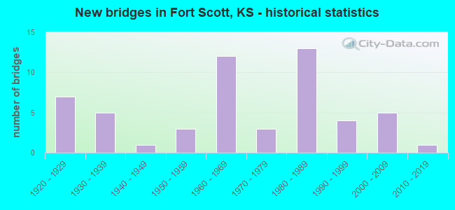
- New bridges - historical statistics
- 71920-1929
- 51930-1939
- 11940-1949
- 31950-1959
- 121960-1969
- 31970-1979
- 131980-1989
- 41990-1999
- 52000-2009
- 12010-2019
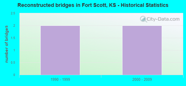
- Reconstructed bridges - Historical Statistics
- 21990-1999
- 22000-2009
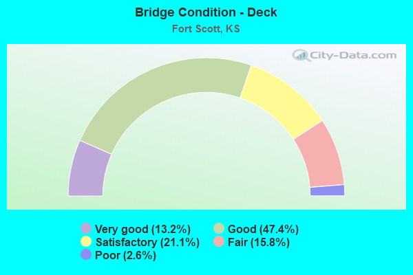
- Bridge Condition - Deck
- 13.2%Very good
- 47.4%Good
- 21.1%Satisfactory
- 15.8%Fair
- 2.6%Poor
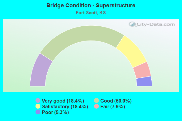
- Bridge Condition - Superstructure
- 18.4%Very good
- 50.0%Good
- 18.4%Satisfactory
- 7.9%Fair
- 5.3%Poor
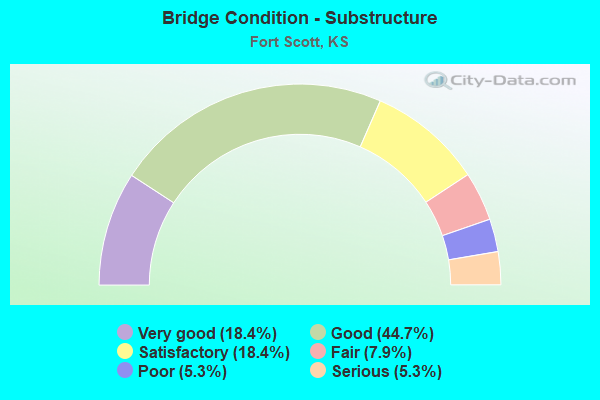
- Bridge Condition - Substructure
- 18.4%Very good
- 44.7%Good
- 18.4%Satisfactory
- 7.9%Fair
- 5.3%Poor
- 5.3%Serious
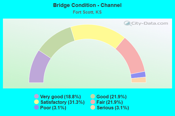
- Bridge Condition - Channel
- 18.8%Very good
- 21.9%Good
- 31.3%Satisfactory
- 21.9%Fair
- 3.1%Poor
- 3.1%Serious
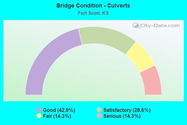
- Bridge Condition - Culverts
- 42.9%Good
- 28.6%Satisfactory
- 14.3%Fair
- 14.3%Serious
Find on map >> Show street view
Structure Number: 999906900060551, Location: 2.59 MI N OF N US-54 JCT (Lat: 37.891944, Lng: -94.705278), Route carried "on" structure: County highway 1196, Year Built: 1985, Status: Open, Structure Length: 8.37m (27.46ft), Average Daily Traffic: 174 (year 2020), Truck Traffic: 4%, Average Future Daily Traffic: 4,577 (year 2041), Design Load: HS 20, Features Intersected: US69 HWY NB & SB, Facility Carried by Structure: Poplar Road
Minimum Vertical Clearance: 30.47m (99.97ft), Kilometerpoint: 0.708, Lanes on structure: 2, Lanes under structure: 4, Owner: State Highway Agency, Approaching Roadway Width: 11.0m (36.1ft), Material/Design: Prestressed concrete continuous, Design/Construction: Stringer/Multi-beam, Number Of Spans In Main Unit: 4, Length of Maximum Span: 26.8m (87.9ft), Curb-To-Curb Width: 11.0m (36.1ft), Out-to-Out Width: 11.7m (38.4ft)
Condition: Deck: Very good, Superstructure: Good, Substructure: Very good, Operating Rating: 66.2 metric tons, Method Used To Determine Operating Rating: Load Factor (LF), Inventory Rating: 31.8 metric tons, Method Used To Determine Inventory Rating: Load Factor (LF), Structural Evaluation: Better than present minimum criteria, Deck Geometry: Equal to present desirable criteria, Underclear: Better than present minimum criteria, Approach Roadway Alignment: Meets minimum limits, Length Of Structure Improvement: 27.45m (90.06ft), Designated Inspection Frequency: Every 24 months, Inspection Date: Febuary 2021, Deck Structure Type: Concrete Precast Panels, Wearing Surface/Protective System: Wearing Surface: Monolithic Concrete, Deck Protection: Epoxy Coated Reinforcing
Find on map >> Show street view
Structure Number: 999906900060561, Location: 3.51 MI N OF N US-54 JCT (Lat: 37.905278, Lng: -94.703056), Route carried "on" structure: US 69, Year Built: 1985, Year Reconstructed: 2004, Status: Open, Structure Length: 0.70m (2.30ft), Average Daily Traffic: 2,996 (year 2020), Truck Traffic: 18%, Average Future Daily Traffic: 4,452 (year 2041), Design Load: HS 20, Features Intersected: WOLVERINE CREEK
Minimum Vertical Clearance: 30.47m (99.97ft), Kilometerpoint: 26.010, Lanes on structure: 4, Base Highway Network: Yes, Owner: State Highway Agency, Approaching Roadway Width: 24.4m (80.1ft), Skew: 23 degrees, Material/Design: Concrete, Design/Construction: Culvert, Number Of Spans In Main Unit: 1, Length of Maximum Span: 6.1m (20.0ft), Curb-To-Curb Width: 24.4m (80.1ft), Out-to-Out Width: 63.6m (208.7ft)
Condition: Channel: Good, Culverts: Good, Operating Rating: 89.8 metric tons, Method Used To Determine Operating Rating: Load Factor (LF), Inventory Rating: 84.9 metric tons, Method Used To Determine Inventory Rating: Load Factor (LF), Structural Evaluation: Better than present minimum criteria, Deck Geometry: Superior to present desirable criteria, Waterway Adequacy: Equal to present minimum criteria, Approach Roadway Alignment: Equal to present desirable criteria, Length Of Structure Improvement: 2.31m (7.58ft), Designated Inspection Frequency: Every 24 months, Inspection Date: Febuary 2021, Deck Structure Type: Concrete Cast-file-Place, Wearing Surface/Protective System: Wearing Surface: Monolithic Concrete
Find on map >> Show street view
Structure Number: 999906900060701, Location: 6.57 MI N CRAWFORD COLN (Lat: 37.767778, Lng: -94.705278), Route carried "on" structure: US 69, Year Built: 1998, Status: Open, Structure Length: 14.84m (48.69ft), Average Daily Traffic: 3,152 (year 2020), Truck Traffic: 22%, Average Future Daily Traffic: 4,503 (year 2041), Design Load: HS 25 or greater, Features Intersected: K-7 & BNSF RR
Minimum Vertical Clearance: 30.47m (99.97ft), Kilometerpoint: 10.491, Lanes on structure: 2, Lanes under structure: 2, Base Highway Network: Yes, Owner: State Highway Agency, Approaching Roadway Width: 12.2m (40.0ft), Skew: 5 degrees, Material/Design: Steel, Design/Construction: Stringer/Multi-beam, Number Of Spans In Main Unit: 4, Length of Maximum Span: 41.5m (136.2ft), Curb-To-Curb Width: 12.2m (40.0ft), Out-to-Out Width: 12.8m (42.0ft)
Condition: Deck: Good, Superstructure: Good, Substructure: Good, Operating Rating: 80.6 metric tons, Method Used To Determine Operating Rating: Load Factor (LF), Inventory Rating: 48.3 metric tons, Method Used To Determine Inventory Rating: Load Factor (LF), Structural Evaluation: Better than present minimum criteria, Deck Geometry: Better than present minimum criteria, Underclear: Superior to present desirable criteria, Approach Roadway Alignment: Equal to present desirable criteria, Length Of Structure Improvement: 48.70m (159.78ft), Designated Inspection Frequency: Every 24 months, Inspection Date: Febuary 2021, Wearing Surface/Protective System: Wearing Surface: Low Slump Concrete, Deck Protection: Epoxy Coated Reinforcing
Find on map >> Show street view
Structure Number: 999906900060711, Location: 6.58 MI N CRAWFORD COLN (Lat: 37.767778, Lng: -94.705000), Route carried "on" structure: US 69, Year Built: 1996, Status: Open, Structure Length: 14.84m (48.69ft), Average Daily Traffic: 3,152 (year 2020), Truck Traffic: 22%, Average Future Daily Traffic: 4,503 (year 2041), Design Load: HS 25 or greater, Features Intersected: K-7 & BNSF RR
Minimum Vertical Clearance: 30.47m (99.97ft), Kilometerpoint: 10.532, Lanes on structure: 2, Lanes under structure: 2, Base Highway Network: Yes, Owner: State Highway Agency, Approaching Roadway Width: 12.2m (40.0ft), Skew: 5 degrees, Material/Design: Steel, Design/Construction: Stringer/Multi-beam, Number Of Spans In Main Unit: 4, Length of Maximum Span: 41.5m (136.2ft), Curb-To-Curb Width: 12.2m (40.0ft), Out-to-Out Width: 13.0m (42.7ft)
Condition: Deck: Good, Superstructure: Very good, Substructure: Good, Operating Rating: 81.5 metric tons, Method Used To Determine Operating Rating: Load Factor (LF), Inventory Rating: 48.8 metric tons, Method Used To Determine Inventory Rating: Load Factor (LF), Structural Evaluation: Better than present minimum criteria, Deck Geometry: Better than present minimum criteria, Underclear: Superior to present desirable criteria, Approach Roadway Alignment: Equal to present desirable criteria, Length Of Structure Improvement: 48.70m (159.78ft), Designated Inspection Frequency: Every 24 months, Inspection Date: Febuary 2021, Wearing Surface/Protective System: Wearing Surface: Low Slump Concrete, Deck Protection: Epoxy Coated Reinforcing
Find on map >> Show street view
Structure Number: 999906900060731, Location: 4.1 MI N OF BOURBON SCOLN (Lat: 37.732500, Lng: -94.704722), Route carried "on" structure: US 69, Year Built: 1998, Status: Open, Structure Length: 0.79m (2.59ft), Average Daily Traffic: 3,152 (year 2020), Truck Traffic: 22%, Average Future Daily Traffic: 4,503 (year 2041), Design Load: HS 20, Features Intersected: BUCK RUN CREEK
Minimum Vertical Clearance: 30.47m (99.97ft), Kilometerpoint: 6.624, Lanes on structure: 4, Base Highway Network: Yes, Owner: State Highway Agency, Approaching Roadway Width: 25.6m (84.0ft), Skew: 23 degrees, Material/Design: Concrete, Design/Construction: Culvert, Number Of Spans In Main Unit: 2, Length of Maximum Span: 3.7m (12.1ft), Curb-To-Curb Width: 25.6m (84.0ft), Out-to-Out Width: 38.1m (125.0ft)
Condition: Channel: Good, Culverts: Good, Inventory Rating: 10.7 metric tons, Method Used To Determine Inventory Rating: Load Factor (LF), Structural Evaluation: High priority of corrective action, Deck Geometry: Superior to present desirable criteria, Waterway Adequacy: Better than present minimum criteria, Approach Roadway Alignment: Equal to present desirable criteria, Length Of Structure Improvement: 2.60m (8.53ft), Designated Inspection Frequency: Every 24 months, Inspection Date: Febuary 2021, Deck Structure Type: Concrete Cast-file-Place, Wearing Surface/Protective System: Wearing Surface: Monolithic Concrete
Find on map >> Show street view
Structure Number: 999906900060091, Location: S JCT US54&US69 (Lat: 37.841667, Lng: -94.702222), Route carried "under" structure: US 54, Year Built: 1967, Structure Length: 0. m, Average Daily Traffic: 6,982 (year 2020), Truck Traffic: 8%, Features Intersected: US-54 EB (WALL STREET), Facility Carried by Structure: US-69 & K-7 HWYS
Minimum Vertical Clearance: 4.72m (15.49ft), Kilometerpoint: 36.011, Lanes on structure: 4, Lanes under structure: 2, Material/Design: Concrete continuous, Design/Construction: Slab, Length of Maximum Span: 21.0m (68.9ft)
Find on map >> Show street view
Structure Number: 999906900060171, Location: 0.48 MI S EJCT US54 (Lat: 37.835833, Lng: -94.704444), Route carried "under" structure: US 69, Year Built: 1969, Structure Length: 0. m, Average Daily Traffic: 6,127 (year 2020), Truck Traffic: 12%, Features Intersected: US69, K7 HWY, Facility Carried by Structure: PED OVERPASS
Minimum Vertical Clearance: 5.27m (17.29ft), Kilometerpoint: 18.211, Lanes under structure: 4, Material/Design: Steel, Design/Construction: Frame, Length of Maximum Span: 31.4m (103.0ft)
Find on map >> Show street view
Structure Number: 999906900060181, Location: 0.23 MI S EJCT US54 (Lat: 37.838889, Lng: -94.702778), Route carried "under" structure: US 69, Year Built: 1969, Structure Length: 0. m, Average Daily Traffic: 6,127 (year 2020), Truck Traffic: 12%, Features Intersected: US69, K7 HWY, Facility Carried by Structure: PED OVERPASS
Minimum Vertical Clearance: 5.11m (16.77ft), Kilometerpoint: 18.602, Lanes under structure: 5, Material/Design: Steel, Design/Construction: Frame, Length of Maximum Span: 31.4m (103.0ft)
Find on map >> Show street view
Structure Number: 999906900060511, Location: N. JCT OF US-54 (Lat: 37.854722, Lng: -94.702500), Route carried "under" structure: US 54, Year Built: 1985, Structure Length: 0. m, Average Daily Traffic: 3,192 (year 2020), Truck Traffic: 16%, Features Intersected: US-54 HIGHWAY, Facility Carried by Structure: US-69 SOUTHBOUND
Minimum Vertical Clearance: 5.01m (16.44ft), Kilometerpoint: 0.489, Lanes on structure: 2, Lanes under structure: 3, Material/Design: Steel continuous, Design/Construction: Stringer/Multi-beam, Length of Maximum Span: 35.7m (117.1ft)
Find on map >> Show street view
Structure Number: 999906900060521, Location: N. JCT OF US-54 NB. (Lat: 37.854722, Lng: -94.702222), Route carried "under" structure: US 54, Year Built: 1985, Structure Length: 0. m, Average Daily Traffic: 3,192 (year 2020), Truck Traffic: 16%, Features Intersected: US-54 HIGHWAY, Facility Carried by Structure: US-69 NORTHBOUND
Minimum Vertical Clearance: 5.02m (16.47ft), Kilometerpoint: 0.515, Lanes on structure: 2, Lanes under structure: 3, Material/Design: Steel continuous, Design/Construction: Stringer/Multi-beam, Length of Maximum Span: 35.7m (117.1ft)
Find on map >> Show street view
Structure Number: 999906900060531, Location: 0.58 MI N OF N US-54 JCT (Lat: 37.863056, Lng: -94.703056), Route carried "under" structure: US 69, Year Built: 1985, Structure Length: 0. m, Average Daily Traffic: 3,637 (year 2020), Truck Traffic: 15%, Features Intersected: US69 HWY NB & SB, Facility Carried by Structure: LOCAL ROAD
Minimum Vertical Clearance: 5.06m (16.60ft), Kilometerpoint: 21.293, Lanes on structure: 2, Lanes under structure: 4, Material/Design: Prestressed concrete continuous, Design/Construction: Stringer/Multi-beam, Length of Maximum Span: 26.8m (87.9ft)
Find on map >> Show street view
Structure Number: 999906900060541, Location: 1.57 MI N OF N US-54 JCT (Lat: 37.877222, Lng: -94.704722), Route carried "under" structure: US 69, Year Built: 1985, Structure Length: 0. m, Average Daily Traffic: 3,637 (year 2020), Truck Traffic: 15%, Features Intersected: US69 HWY NB & SB, Facility Carried by Structure: LOCAL ROAD
Minimum Vertical Clearance: 5.02m (16.47ft), Kilometerpoint: 22.878, Lanes on structure: 2, Lanes under structure: 4, Material/Design: Prestressed concrete continuous, Design/Construction: Stringer/Multi-beam, Length of Maximum Span: 26.8m (87.9ft)
Find on map >> Show street view
Structure Number: 999906900060551, Location: 2.59 MI N OF N US-54 JCT (Lat: 37.891944, Lng: -94.705278), Route carried "under" structure: US 69, Year Built: 1985, Structure Length: 0. m, Average Daily Traffic: 2,996 (year 2020), Truck Traffic: 18%, Features Intersected: US69 HWY NB & SB, Facility Carried by Structure: Poplar Road
Minimum Vertical Clearance: 5.17m (16.96ft), Kilometerpoint: 24.520, Lanes on structure: 2, Lanes under structure: 4, Material/Design: Prestressed concrete continuous, Design/Construction: Stringer/Multi-beam, Length of Maximum Span: 26.8m (87.9ft)
Find on map >> Show street view
Structure Number: 999906900060701, Location: 6.57 MI N CRAWFORD COLN (Lat: 37.767778, Lng: -94.705278), Route carried "under" structure: State highway 7, Year Built: 1998, Structure Length: 0. m, Average Daily Traffic: 608 (year 2020), Truck Traffic: 15%, Features Intersected: K-7 & BNSF RR, Facility Carried by Structure: US-69 HWY SB
Minimum Vertical Clearance: 7.31m (23.98ft), Kilometerpoint: 17.257, Lanes on structure: 2, Lanes under structure: 2, Material/Design: Steel, Design/Construction: Stringer/Multi-beam, Length of Maximum Span: 41.5m (136.2ft)