Bridge Statistics for Gadsden, Alabama (AL)
Condition, Traffic, Stress, Structural Evaluation, Project Costs
- National Bridge Inventory (NBI) Statistics
- 78Number of bridges
- 1,631ft / 497mTotal length
- $186,487,000Total costs
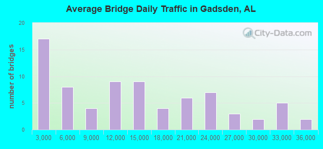
- 1,015,532Total average daily traffic
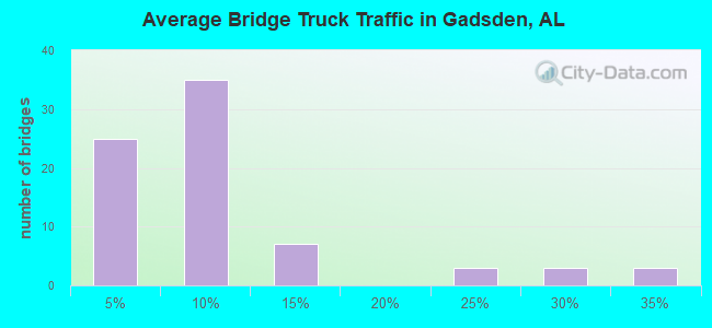
- 103,189Total average daily truck traffic
- National Bridge Inventory (NBI) Registered Bridges for Gadsden
- No street view available for this location
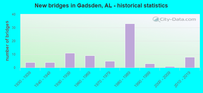
- New bridges - historical statistics
- 41930-1939
- 41940-1949
- 111950-1959
- 91960-1969
- 51970-1979
- 331980-1989
- 31990-1999
- 12000-2009
- 82010-2019
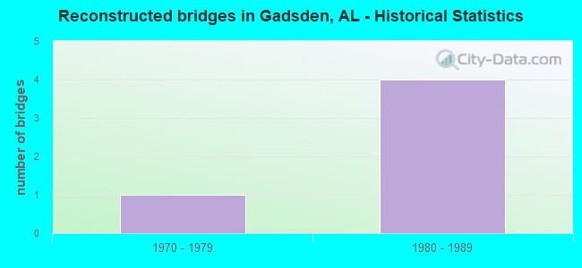
- Reconstructed bridges - Historical Statistics
- 11970-1979
- 41980-1989
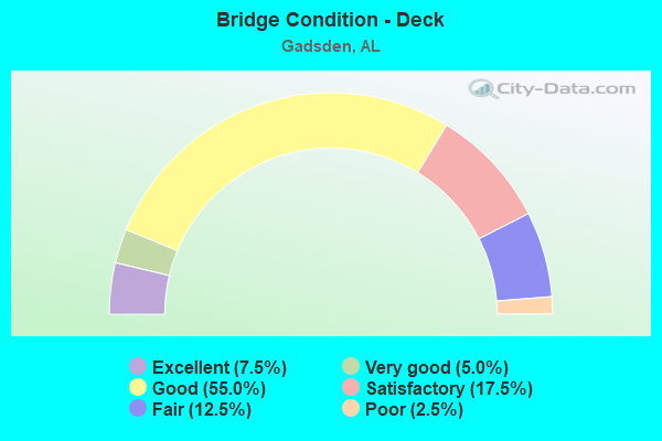
- Bridge Condition - Deck
- 7.5%Excellent
- 5.0%Very good
- 55.0%Good
- 17.5%Satisfactory
- 12.5%Fair
- 2.5%Poor
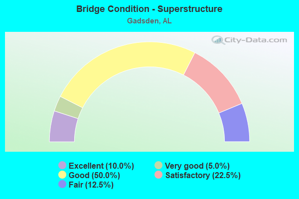
- Bridge Condition - Superstructure
- 10.0%Excellent
- 5.0%Very good
- 50.0%Good
- 22.5%Satisfactory
- 12.5%Fair
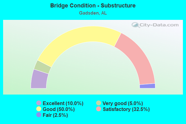
- Bridge Condition - Substructure
- 10.0%Excellent
- 5.0%Very good
- 50.0%Good
- 32.5%Satisfactory
- 2.5%Fair
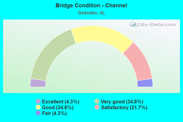
- Bridge Condition - Channel
- 4.3%Excellent
- 34.8%Very good
- 34.8%Good
- 21.7%Satisfactory
- 4.3%Fair

- Bridge Condition - Culverts
- 5.3%Excellent
- 21.1%Very good
- 36.8%Good
- 31.6%Satisfactory
- 5.3%Fair
Find on map >> Show street view
Structure Number: 741, Location: FORREST AVE * BLACKCREEK (Lat: 34.019233, Lng: -86.031497), Route carried "on" structure: City street , Year Built: 1930, Status: Open, Structure Length: 3.95m (12.96ft), Average Daily Traffic: 8,820 (year 2021), Truck Traffic: 1%, Average Future Daily Traffic: 8,769 (year 2041), Design Load: H 20, Features Intersected: BLACK CREEK, Facility Carried by Structure: FORREST AVE
Minimum Vertical Clearance: 30+ m (98+ ft), Kilometerpoint: 2.200, Lanes on structure: 2, Owner: City or Municipal Highway Agency, Approaching Roadway Width: 19.8m (65.0ft), Material/Design: Concrete, Design/Construction: Tee Beam, Number Of Spans In Main Unit: 5, Length of Maximum Span: 7.9m (25.9ft), Curb or Sidewalk Widths: Left: 1.5m (4.9ft), Right: 1.5m (4.9ft), Curb-To-Curb Width: 12.1m (39.7ft), Out-to-Out Width: 15.9m (52.2ft)
Condition: Deck: Good, Superstructure: Good, Substructure: Good, Channel: Good, Operating Rating: 41.5 metric tons, Method Used To Determine Operating Rating: Load Factor (LF), Inventory Rating: 24.9 metric tons, Method Used To Determine Inventory Rating: Load Factor (LF), Structural Evaluation: Equal to present minimum criteria, Deck Geometry: Somewhat better than minimum adequacy, Waterway Adequacy: Equal to present desirable criteria, Approach Roadway Alignment: Better than present minimum criteria, Length Of Structure Improvement: 4.90m (16.08ft), Designated Inspection Frequency: Every 24 months, Inspection Date: August 2021, Bridge Improvement Cost: $1,748,000, Roadway Improvement Cost: $175,000, Total Project Cost: $1,923,000 ( Estimate for 2022), Deck Structure Type: Concrete Cast-file-Place, Wearing Surface/Protective System: Wearing Surface: Bituminous
Find on map >> Show street view
Structure Number: 1236, Location: ELMWOOD AVE * NOWLIN BRAN (Lat: 34.008333, Lng: -85.980000), Route carried "on" structure: City street , Year Built: 1935, Year Reconstructed: 1991, Status: Open, Structure Length: 1.13m (3.71ft), Average Daily Traffic: 726 (year 2021), Truck Traffic: 1%, Average Future Daily Traffic: 1,003 (year 2041), Design Load: HS 15, Features Intersected: NOWLIN BRANCH, Facility Carried by Structure: ELMWOOD AVE
Minimum Vertical Clearance: 30+ m (98+ ft), Kilometerpoint: 4.749, Lanes on structure: 2, Owner: City or Municipal Highway Agency, Approaching Roadway Width: 9.4m (30.8ft), Material/Design: Concrete, Design/Construction: Culvert, Number Of Spans In Main Unit: 3, Length of Maximum Span: 3.7m (12.1ft), Curb or Sidewalk Widths: Left: 1.0m (3.3ft), Right: 2.6m (8.5ft), Curb-To-Curb Width: 9.4m (30.8ft), Out-to-Out Width: 13.4m (44.0ft)
Condition: Channel: Very good, Culverts: Good, Operating Rating: 53.2 metric tons, Method Used To Determine Operating Rating: Load Factor (LF), Inventory Rating: 31.9 metric tons, Method Used To Determine Inventory Rating: Load Factor (LF), Structural Evaluation: Better than present minimum criteria, Deck Geometry: Equal to present minimum criteria, Waterway Adequacy: Superior to present desirable criteria, Approach Roadway Alignment: Better than present minimum criteria, Length Of Structure Improvement: 1.80m (5.91ft), Designated Inspection Frequency: Every 24 months, Inspection Date: Febuary 2021, Bridge Improvement Cost: $457,000, Roadway Improvement Cost: $46,000, Total Project Cost: $503,000 ( Estimate for 2022)
Find on map >> Show street view
Structure Number: 1241, Location: E BROAD ST * NOWLINBRANCH (Lat: 34.006200, Lng: -85.989000), Route carried "on" structure: City street , Year Built: 1991, Status: Open, Structure Length: 0.79m (2.59ft), Average Daily Traffic: 12,222 (year 2021), Truck Traffic: 1%, Average Future Daily Traffic: 6,264 (year 2041), Design Load: HS 15, Features Intersected: NOWLIN BRANCH, Facility Carried by Structure: EAST BROAD ST
Minimum Vertical Clearance: 30+ m (98+ ft), Kilometerpoint: 4.749, Lanes on structure: 2, Owner: City or Municipal Highway Agency, Approaching Roadway Width: 8.0m (26.2ft), Material/Design: Concrete, Design/Construction: Culvert, Number Of Spans In Main Unit: 2, Length of Maximum Span: 3.7m (12.1ft), Curb or Sidewalk Widths: Left: 2.8m (9.2ft), Right: 0.0m, Curb-To-Curb Width: 10.0m (32.8ft), Out-to-Out Width: 13.9m (45.6ft)
Condition: Channel: Good, Culverts: Very good, Operating Rating: 35.6 metric tons, Method Used To Determine Operating Rating: Load Factor (LF), Inventory Rating: 21.3 metric tons, Method Used To Determine Inventory Rating: Load Factor (LF), Structural Evaluation: Somewhat better than minimum adequacy, Deck Geometry: Meets minimum limits, Waterway Adequacy: Equal to present desirable criteria, Approach Roadway Alignment: Equal to present desirable criteria, Length Of Structure Improvement: 1.45m (4.76ft), Designated Inspection Frequency: Every 24 months, Inspection Date: Febuary 2021, Bridge Improvement Cost: $377,000, Roadway Improvement Cost: $38,000, Total Project Cost: $415,000 ( Estimate for 2022)
Find on map >> Show street view
Structure Number: 1352, Location: 0.5 MI NE US HWY 72 E (Lat: 34.750422, Lng: -86.441953), Route carried "on" structure: County highway 306, Year Built: 1935, Status: Open, Structure Length: 4.57m (14.99ft), Average Daily Traffic: 880 (year 1992), Truck Traffic: 1%, Average Future Daily Traffic: 1,260 (year 2035), Design Load: H 15, Features Intersected: FLINT RIVER RELIEF, Facility Carried by Structure: BROWNSBORO RD
Minimum Vertical Clearance: 30+ m (98+ ft), Kilometerpoint: 0.010, Lanes on structure: 2, Owner: County Highway Agency, Approaching Roadway Width: 7.9m (25.9ft), Material/Design: Concrete, Design/Construction: Tee Beam, Number Of Spans In Main Unit: 5, Length of Maximum Span: 9.1m (29.9ft), Curb-To-Curb Width: 7.3m (24.0ft), Out-to-Out Width: 8.4m (27.6ft)
Condition: Deck: Satisfactory, Superstructure: Good, Substructure: Satisfactory, Channel: Satisfactory, Operating Rating: 59.0 metric tons, Method Used To Determine Operating Rating: Allowable Stress (AS), Inventory Rating: 43.8 metric tons, Method Used To Determine Inventory Rating: Allowable Stress (AS), Structural Evaluation: Equal to present minimum criteria, Deck Geometry: Meets minimum limits, Waterway Adequacy: Better than present minimum criteria, Approach Roadway Alignment: Somewhat better than minimum adequacy, Length Of Structure Improvement: 5.56m (18.24ft), Designated Inspection Frequency: Every 24 months, Inspection Date: June 2020, Bridge Improvement Cost: $1,030,000, Roadway Improvement Cost: $103,000, Total Project Cost: $1,133,000 ( Estimate for 2022), Deck Structure Type: Concrete Cast-file-Place
Find on map >> Show street view
Structure Number: 2054, Location: 1.5 MI E US HWY 231 NO (Lat: 34.902753, Lng: -86.539919), Route carried "on" structure: County highway 137, Year Built: 1939, Status: Open, Structure Length: 0.88m (2.89ft), Average Daily Traffic: 920 (year 1992), Truck Traffic: 1%, Average Future Daily Traffic: 1,255 (year 2035), Design Load: HS 20, Features Intersected: SANDIDGE CREEK, Facility Carried by Structure: WALKER LA
Minimum Vertical Clearance: 30+ m (98+ ft), Kilometerpoint: 0.010, Lanes on structure: 2, Owner: County Highway Agency, Approaching Roadway Width: 9.1m (29.9ft), Material/Design: Masonry, Design/Construction: Culvert, Number Of Spans In Main Unit: 2, Length of Maximum Span: 3.7m (12.1ft), Curb-To-Curb Width: 6.3m (20.7ft), Out-to-Out Width: 6.9m (22.6ft)
Condition: Channel: Satisfactory, Culverts: Satisfactory, Operating Rating: 32.7 metric tons, Method Used To Determine Operating Rating: Field evaluation and documented engineering judgment, Inventory Rating: 23.6 metric tons, Method Used To Determine Inventory Rating: Field evaluation and documented engineering judgment, Structural Evaluation: Equal to present minimum criteria, Deck Geometry: High priority of corrective action, Waterway Adequacy: Equal to present minimum criteria, Approach Roadway Alignment: Equal to present minimum criteria, Length Of Structure Improvement: 1.55m (5.09ft), Designated Inspection Frequency: Every 24 months, Inspection Date: Febuary 2021, Bridge Improvement Cost: $277,000, Roadway Improvement Cost: $28,000, Total Project Cost: $305,000 ( Estimate for 2022)
Find on map >> Show street view
Structure Number: 2237, Location: S 11TH ST * BLACK CREEK (Lat: 33.997508, Lng: -86.025825), Route carried "on" structure: City street , Year Built: 1940, Status: Open, Structure Length: 1.31m (4.30ft), Average Daily Traffic: 8,256 (year 2021), Truck Traffic: 2%, Average Future Daily Traffic: 11,558 (year 2041), Design Load: HS 15, Features Intersected: BLACK CREEK, Facility Carried by Structure: S 11TH ST
Minimum Vertical Clearance: 30+ m (98+ ft), Kilometerpoint: 0.200, Lanes on structure: 2, Owner: City or Municipal Highway Agency, Approaching Roadway Width: 9.8m (32.2ft), Material/Design: Concrete, Design/Construction: Culvert, Number Of Spans In Main Unit: 4, Length of Maximum Span: 3.0m (9.8ft)
Condition: Channel: Good, Culverts: Good, Operating Rating: 48.5 metric tons, Method Used To Determine Operating Rating: Load Factor (LF), Inventory Rating: 29.1 metric tons, Method Used To Determine Inventory Rating: Load Factor (LF), Structural Evaluation: Better than present minimum criteria, Waterway Adequacy: Equal to present minimum criteria, Approach Roadway Alignment: Equal to present minimum criteria, Length Of Structure Improvement: 1.99m (6.53ft), Designated Inspection Frequency: Every 24 months, Inspection Date: Febuary 2021, Bridge Improvement Cost: $368,000, Roadway Improvement Cost: $37,000, Total Project Cost: $405,000 ( Estimate for 2022)
Find on map >> Show street view
Structure Number: 2364, Location: PARK AVE* RELIEF DITCH (Lat: 34.971667, Lng: -85.975000), Route carried "on" structure: City street , Year Built: 1940, Year Reconstructed: 1991, Status: Open, Structure Length: 0.66m (2.17ft), Average Daily Traffic: 1,254 (year 2021), Truck Traffic: 1%, Average Future Daily Traffic: 1,881 (year 2041), Design Load: HS 15, Features Intersected: RELIEF DITCH, Facility Carried by Structure: PARK AVE
Minimum Vertical Clearance: 30+ m (98+ ft), Kilometerpoint: 5.499, Lanes on structure: 2, Owner: City or Municipal Highway Agency, Approaching Roadway Width: 9.3m (30.5ft), Skew: 3 degrees, Material/Design: Concrete, Design/Construction: Culvert, Number Of Spans In Main Unit: 2, Length of Maximum Span: 3.0m (9.8ft)
Condition: Channel: Very good, Culverts: Very good, Operating Rating: 59.5 metric tons, Method Used To Determine Operating Rating: Load Factor (LF), Inventory Rating: 35.7 metric tons, Method Used To Determine Inventory Rating: Load Factor (LF), Structural Evaluation: Equal to present desirable criteria, Waterway Adequacy: Equal to present desirable criteria, Approach Roadway Alignment: Better than present minimum criteria, Length Of Structure Improvement: 1.30m (4.27ft), Designated Inspection Frequency: Every 24 months, Inspection Date: Febuary 2021, Bridge Improvement Cost: $464,000, Roadway Improvement Cost: $46,000, Total Project Cost: $510,000 ( Estimate for 2022)
Find on map >> Show street view
Structure Number: 2839, Location: HOKES ST * RELIEF DITCH (Lat: 33.991667, Lng: -85.968333), Route carried "on" structure: City street , Year Built: 1945, Status: Open, Structure Length: 0.69m (2.26ft), Average Daily Traffic: 4,340 (year 2021), Truck Traffic: 1%, Average Future Daily Traffic: 6,270 (year 2041), Design Load: HS 15, Features Intersected: RELIEF DITCH, Facility Carried by Structure: HOKES ST
Minimum Vertical Clearance: 30+ m (98+ ft), Kilometerpoint: 5.749, Lanes on structure: 2, Owner: City or Municipal Highway Agency, Approaching Roadway Width: 9.9m (32.5ft), Skew: 3 degrees, Material/Design: Concrete, Design/Construction: Culvert, Number Of Spans In Main Unit: 2, Length of Maximum Span: 3.0m (9.8ft), Curb-To-Curb Width: 11.1m (36.4ft), Out-to-Out Width: 28.3m (92.8ft)
Condition: Channel: Very good, Culverts: Very good, Operating Rating: 62.5 metric tons, Method Used To Determine Operating Rating: Load Factor (LF), Inventory Rating: 37.5 metric tons, Method Used To Determine Inventory Rating: Load Factor (LF), Structural Evaluation: Equal to present desirable criteria, Deck Geometry: Somewhat better than minimum adequacy, Waterway Adequacy: Equal to present desirable criteria, Approach Roadway Alignment: Better than present minimum criteria, Length Of Structure Improvement: 1.32m (4.33ft), Designated Inspection Frequency: Every 24 months, Inspection Date: Febuary 2021, Bridge Improvement Cost: $707,000, Roadway Improvement Cost: $71,000, Total Project Cost: $778,000 ( Estimate for 2022)
Find on map >> Show street view
Structure Number: 3247, Location: CHESTNUT ST * NOWLIN BR (Lat: 34.000000, Lng: -85.966667), Route carried "on" structure: City street , Year Built: 1948, Year Reconstructed: 1991, Status: Open, Structure Length: 0.76m (2.49ft), Average Daily Traffic: 1,170 (year 2021), Truck Traffic: 1%, Average Future Daily Traffic: 1,914 (year 2041), Design Load: HS 15, Features Intersected: NOWLIN BRANCH, Facility Carried by Structure: CHESTNUT ST
Minimum Vertical Clearance: 30+ m (98+ ft), Kilometerpoint: 4.749, Lanes on structure: 2, Owner: City or Municipal Highway Agency, Approaching Roadway Width: 7.6m (24.9ft), Material/Design: Concrete, Design/Construction: Culvert, Number Of Spans In Main Unit: 2, Length of Maximum Span: 3.7m (12.1ft)
Condition: Channel: Good, Culverts: Good, Operating Rating: 63.9 metric tons, Method Used To Determine Operating Rating: Load Factor (LF), Inventory Rating: 38.3 metric tons, Method Used To Determine Inventory Rating: Load Factor (LF), Structural Evaluation: Better than present minimum criteria, Waterway Adequacy: Equal to present desirable criteria, Approach Roadway Alignment: Equal to present desirable criteria, Length Of Structure Improvement: 1.41m (4.63ft), Designated Inspection Frequency: Every 24 months, Inspection Date: Febuary 2021, Bridge Improvement Cost: $325,000, Roadway Improvement Cost: $33,000, Total Project Cost: $358,000 ( Estimate for 2022)
Find on map >> Show street view
Structure Number: 3666, Location: HICKORY ST * BLACK CREEK (Lat: 34.006300, Lng: -86.029600), Route carried "on" structure: City street , Year Built: 1950, Status: Posted for load, Structure Length: 3.67m (12.04ft), Average Daily Traffic: 1,764 (year 2022), Truck Traffic: 6%, Average Future Daily Traffic: 893 (year 2042), Design Load: HS 15, Features Intersected: BLACK CREEK, Facility Carried by Structure: HICKORY ST
Minimum Vertical Clearance: 30+ m (98+ ft), Kilometerpoint: 1.600, Lanes on structure: 2, Owner: City or Municipal Highway Agency, Approaching Roadway Width: 9.1m (29.9ft), Skew: 1 degrees, Material/Design: Steel, Design/Construction: Stringer/Multi-beam, Number Of Spans In Main Unit: 4, Length of Maximum Span: 9.2m (30.2ft), Curb-To-Curb Width: 9.1m (29.9ft), Out-to-Out Width: 9.8m (32.2ft)
Condition: Deck: Satisfactory, Superstructure: Satisfactory, Substructure: Satisfactory, Channel: Satisfactory, Operating Rating: 26.1 metric tons, Method Used To Determine Operating Rating: Load Factor (LF), Inventory Rating: 15.7 metric tons, Method Used To Determine Inventory Rating: Load Factor (LF), Structural Evaluation: Meets minimum limits, Deck Geometry: Somewhat better than minimum adequacy, Waterway Adequacy: Better than present minimum criteria, Approach Roadway Alignment: Equal to present minimum criteria, Bridge Posting: Required (Relationship of Operating Rating to Maximum Legal Load: > 39.9% below), Length Of Structure Improvement: 4.59m (15.06ft), Designated Inspection Frequency: Every 24 months, Other Special Inspection Frequency: Every 12 months, Inspection Date: Febuary 2022, Other Special Inspection Date: Febuary 2022, Bridge Improvement Cost: $1,007,000, Roadway Improvement Cost: $101,000, Total Project Cost: $1,108,000 ( Estimate for 2022), Deck Structure Type: Concrete Cast-file-Place, Wearing Surface/Protective System: Wearing Surface: Bituminous
Find on map >> Show street view
Structure Number: 4754, Location: US 431 * US 411 (Lat: 34.013142, Lng: -85.996158), Route carried "on" structure: US 431, Year Built: 1954, Status: Temporarily open, Structure Length: 32.19m (105.61ft), Average Daily Traffic: 35,967 (year 2019), Truck Traffic: 6%, Average Future Daily Traffic: 50,354 (year 2039), Design Load: HS 20, Features Intersected: COOSA RV * US 411
Minimum Vertical Clearance: 30+ m (98+ ft), Kilometerpoint: 419.073, Lanes on structure: 4, Lanes under structure: 4, Base Highway Network: Yes, Owner: State Highway Agency, Approaching Roadway Width: 17.1m (56.1ft), Navigation Control: Yes ( Vertical Clearance: 10.7m (35.1ft), Horizontal Clearance: 45.7m (149.9ft)), Material/Design: Steel continuous, Design/Construction: Stringer/Multi-beam, Number Of Spans In Main Unit: 5, Number Of Approach Spans: 13, Length of Maximum Span: 48.8m (160.1ft), Curb or Sidewalk Widths: Left: 1.8m (5.9ft), Right: 1.8m (5.9ft), Curb-To-Curb Width: 17.1m (56.1ft), Out-to-Out Width: 20.8m (68.2ft)
Condition: Deck: Fair, Superstructure: Fair, Substructure: Satisfactory, Channel: Good, Operating Rating: 42.1 metric tons, Method Used To Determine Operating Rating: Load Factor (LF), Inventory Rating: 25.2 metric tons, Method Used To Determine Inventory Rating: Load Factor (LF), Structural Evaluation: Somewhat better than minimum adequacy, Deck Geometry: Somewhat better than minimum adequacy, Underclear: High priority of corrective action, Waterway Adequacy: Superior to present desirable criteria, Approach Roadway Alignment: Equal to present desirable criteria, Length Of Structure Improvement: 32.19m (105.61ft), Designated Inspection Frequency: Every 24 months, Critical Feature Inspection Frequency: Every 24 months, Underwater Inspection Frequency: Every 24 months, Inspection Date: May 2021, Critical Feature Inspection Date: May 2021, Underwater Inspection Date: May 2020, Bridge Improvement Cost: $15,008,000, Roadway Improvement Cost: $1,501,000, Total Project Cost: $16,509,000 ( Estimate for 2022), Deck Structure Type: Concrete Cast-file-Place, Wearing Surface/Protective System: Wearing Surface: Epoxy Overlay, Membrane: Epoxy, Deck Protection: Bituminous
Find on map >> Show street view
Structure Number: 5068, Location: .1 MI.SO.COOSA RIVER (Lat: 34.011728, Lng: -85.992903), Route carried "on" structure: US 431, Year Built: 1955, Status: Open, Structure Length: 3.54m (11.61ft), Average Daily Traffic: 32,746 (year 2019), Truck Traffic: 7%, Average Future Daily Traffic: 45,844 (year 2039), Design Load: HS 20, Features Intersected: LAKE STREET
Minimum Vertical Clearance: 30+ m (98+ ft), Kilometerpoint: 418.854, Lanes on structure: 4, Lanes under structure: 2, Base Highway Network: Yes, Owner: State Highway Agency, Approaching Roadway Width: 17.1m (56.1ft), Skew: 10 degrees, Material/Design: Concrete continuous, Design/Construction: Tee Beam, Number Of Spans In Main Unit: 3, Length of Maximum Span: 14.6m (47.9ft), Curb or Sidewalk Widths: Left: 1.8m (5.9ft), Right: 1.8m (5.9ft), Curb-To-Curb Width: 17.1m (56.1ft), Out-to-Out Width: 20.7m (67.9ft)
Condition: Deck: Satisfactory, Superstructure: Good, Substructure: Good, Channel: Very good, Operating Rating: 42.5 metric tons, Method Used To Determine Operating Rating: Load Factor (LF), Inventory Rating: 25.0 metric tons, Method Used To Determine Inventory Rating: Load Factor (LF), Structural Evaluation: Equal to present minimum criteria, Deck Geometry: Somewhat better than minimum adequacy, Underclear: High priority of corrective action, Approach Roadway Alignment: Better than present minimum criteria, Length Of Structure Improvement: 4.45m (14.60ft), Designated Inspection Frequency: Every 24 months, Inspection Date: May 2021, Bridge Improvement Cost: $2,042,000, Roadway Improvement Cost: $204,000, Total Project Cost: $2,246,000 ( Estimate for 2022), Deck Structure Type: Concrete Cast-file-Place
Find on map >> Show street view
Structure Number: 5392, Location: @ BLACK CREEK PKWY (Lat: 33.990906, Lng: -86.045486), Route carried "on" structure: County highway 129, Year Built: 1956, Status: Closed, Structure Length: 4.57m (14.99ft), Average Daily Traffic: 10,500 (year 2003), Truck Traffic: 4%, Average Future Daily Traffic: 10,500 (year 2030), Features Intersected: BIG WILLS CREEK, Facility Carried by Structure: SUTTON BRIDGE RD.
Minimum Vertical Clearance: 30+ m (98+ ft), Kilometerpoint: 0.010, Lanes on structure: 2, Owner: County Highway Agency, Approaching Roadway Width: 8.5m (27.9ft), Material/Design: Concrete, Design/Construction: Stringer/Multi-beam, Number Of Spans In Main Unit: 5, Number Of Approach Spans: 1, Length of Maximum Span: 9.1m (29.9ft), Curb or Sidewalk Widths: Left: 0.2m (0.7ft), Right: 0.2m (0.7ft), Curb-To-Curb Width: 6.9m (22.6ft), Out-to-Out Width: 7.3m (24.0ft)
Condition: Deck: Poor, Superstructure: Fair, Substructure: Fair, Channel: Satisfactory, Waterway Adequacy: Better than present minimum criteria, Approach Roadway Alignment: Somewhat better than minimum adequacy, Bridge Posting: Required (Relationship of Operating Rating to Maximum Legal Load: > 39.9% below), Length Of Structure Improvement: 5.56m (18.24ft), Designated Inspection Frequency: Every 24 months, Underwater Inspection Frequency: Every 48 months, Other Special Inspection Frequency: Every 12 months, Inspection Date: January 2011, Underwater Inspection Date: December 2009, Other Special Inspection Date: January 2011, Bridge Improvement Cost: $916,000, Roadway Improvement Cost: $92,000, Total Project Cost: $1,008,000 ( Estimate for 2022), Deck Structure Type: Concrete Cast-file-Place, Wearing Surface/Protective System: Wearing Surface: Bituminous
Find on map >> Show street view
Structure Number: 6526, Location: US 431 .6 MI SO.US 278 (Lat: 33.989042, Lng: -85.966856), Route carried "on" structure: US 431, Year Built: 1959, Status: Open, Structure Length: 7.32m (24.02ft), Average Daily Traffic: 9,437 (year 2020), Truck Traffic: 9%, Average Future Daily Traffic: 13,211 (year 2040), Design Load: HS 20, Features Intersected: ATN RR
Minimum Vertical Clearance: 30+ m (98+ ft), Kilometerpoint: 415.055, Lanes on structure: 2, Base Highway Network: Yes, Owner: State Highway Agency, Approaching Roadway Width: 8.7m (28.5ft), Skew: 14 degrees, Material/Design: Concrete, Design/Construction: Tee Beam, Number Of Spans In Main Unit: 5, Length of Maximum Span: 14.6m (47.9ft), Curb-To-Curb Width: 8.7m (28.5ft), Out-to-Out Width: 9.4m (30.8ft)
Condition: Deck: Satisfactory, Superstructure: Fair, Substructure: Good, Operating Rating: 65.7 metric tons, Method Used To Determine Operating Rating: Load Factor (LF), Inventory Rating: 39.4 metric tons, Method Used To Determine Inventory Rating: Load Factor (LF), Structural Evaluation: Somewhat better than minimum adequacy, Deck Geometry: High priority of corrective action, Underclear: Somewhat better than minimum adequacy, Approach Roadway Alignment: Equal to present minimum criteria, Length Of Structure Improvement: 8.35m (27.40ft), Designated Inspection Frequency: Every 24 months, Inspection Date: September 2021, Bridge Improvement Cost: $1,717,000, Roadway Improvement Cost: $172,000, Total Project Cost: $1,889,000 ( Estimate for 2022), Deck Structure Type: Concrete Cast-file-Place, Wearing Surface/Protective System: Wearing Surface: Bituminous
Find on map >> Show street view
Structure Number: 6527, Location: U S 431 .6 MI. SO. US 278 (Lat: 33.988964, Lng: -85.966669), Route carried "on" structure: US 431, Year Built: 1959, Status: Open, Structure Length: 7.32m (24.02ft), Average Daily Traffic: 9,437 (year 2020), Truck Traffic: 9%, Average Future Daily Traffic: 13,211 (year 2040), Design Load: HS 20, Features Intersected: ATN RR
Minimum Vertical Clearance: 30+ m (98+ ft), Kilometerpoint: 415.055, Lanes on structure: 2, Base Highway Network: Yes, Owner: State Highway Agency, Approaching Roadway Width: 8.7m (28.5ft), Skew: 14 degrees, Material/Design: Concrete, Design/Construction: Tee Beam, Number Of Spans In Main Unit: 5, Length of Maximum Span: 14.6m (47.9ft), Curb-To-Curb Width: 8.7m (28.5ft), Out-to-Out Width: 9.4m (30.8ft)
Condition: Deck: Fair, Superstructure: Fair, Substructure: Satisfactory, Operating Rating: 65.7 metric tons, Method Used To Determine Operating Rating: Load Factor (LF), Inventory Rating: 39.4 metric tons, Method Used To Determine Inventory Rating: Load Factor (LF), Structural Evaluation: Somewhat better than minimum adequacy, Deck Geometry: High priority of corrective action, Underclear: Somewhat better than minimum adequacy, Approach Roadway Alignment: Equal to present minimum criteria, Length Of Structure Improvement: 8.35m (27.40ft), Designated Inspection Frequency: Every 24 months, Inspection Date: September 2021, Bridge Improvement Cost: $1,717,000, Roadway Improvement Cost: $172,000, Total Project Cost: $1,889,000 ( Estimate for 2022), Deck Structure Type: Concrete Cast-file-Place, Wearing Surface/Protective System: Wearing Surface: Bituminous
Find on map >> Show street view
Structure Number: 6528, Location: U S 431 * GOODYEAR AVE (Lat: 34.007139, Lng: -85.975381), Route carried "on" structure: US 431, Year Built: 1959, Status: Open, Structure Length: 0.76m (2.49ft), Average Daily Traffic: 21,000 (year 2019), Truck Traffic: 9%, Average Future Daily Traffic: 29,400 (year 2039), Design Load: H 15, Features Intersected: BRANCH
Minimum Vertical Clearance: 30+ m (98+ ft), Kilometerpoint: 417.202, Lanes on structure: 6, Base Highway Network: Yes, Owner: State Highway Agency, Approaching Roadway Width: 21.9m (71.9ft), Skew: 4 degrees, Material/Design: Concrete, Design/Construction: Culvert, Number Of Spans In Main Unit: 2, Length of Maximum Span: 3.0m (9.8ft)
Condition: Channel: Good, Culverts: Satisfactory, Operating Rating: 44.2 metric tons, Method Used To Determine Operating Rating: Load Factor (LF), Inventory Rating: 26.5 metric tons, Method Used To Determine Inventory Rating: Load Factor (LF), Structural Evaluation: Equal to present minimum criteria, Waterway Adequacy: Equal to present minimum criteria, Approach Roadway Alignment: Equal to present desirable criteria, Length Of Structure Improvement: 1.41m (4.63ft), Designated Inspection Frequency: Every 24 months, Inspection Date: June 2021, Bridge Improvement Cost: $951,000, Roadway Improvement Cost: $95,000, Total Project Cost: $1,046,000 ( Estimate for 2022), Wearing Surface/Protective System: Wearing Surface: Bituminous
Find on map >> Show street view
Structure Number: 6529, Location: US 431 * NOWLIN CREEK (Lat: 34.008333, Lng: -85.983333), Route carried "on" structure: US 431, Year Built: 1959, Status: Open, Structure Length: 0.94m (3.08ft), Average Daily Traffic: 21,748 (year 2019), Truck Traffic: 10%, Average Future Daily Traffic: 30,447 (year 2039), Design Load: H 15, Features Intersected: NOWLIN BRANCH
Minimum Vertical Clearance: 30+ m (98+ ft), Kilometerpoint: 417.969, Lanes on structure: 6, Base Highway Network: Yes, Owner: State Highway Agency, Approaching Roadway Width: 21.9m (71.9ft), Skew: 4 degrees, Material/Design: Concrete, Design/Construction: Culvert, Number Of Spans In Main Unit: 2, Length of Maximum Span: 3.0m (9.8ft)
Condition: Channel: Very good, Culverts: Fair, Operating Rating: 36.4 metric tons, Method Used To Determine Operating Rating: Load Factor (LF), Inventory Rating: 21.9 metric tons, Method Used To Determine Inventory Rating: Load Factor (LF), Structural Evaluation: Somewhat better than minimum adequacy, Waterway Adequacy: Equal to present minimum criteria, Approach Roadway Alignment: Equal to present desirable criteria, Length Of Structure Improvement: 1.61m (5.28ft), Designated Inspection Frequency: Every 24 months, Inspection Date: June 2021, Bridge Improvement Cost: $1,950,000, Roadway Improvement Cost: $195,000, Total Project Cost: $2,145,000 ( Estimate for 2022), Wearing Surface/Protective System: Wearing Surface: Bituminous
Find on map >> Show street view
Structure Number: 7545, Location: I59 * BIG WILLS CK (Lat: 34.011411, Lng: -86.075822), Route carried "on" structure: Interstate 59, Year Built: 1962, Status: Open, Structure Length: 18.35m (60.20ft), Average Daily Traffic: 14,268 (year 2018), Truck Traffic: 24%, Average Future Daily Traffic: 19,975 (year 2038), Design Load: HS 20, Features Intersected: BIG WILLS CREEK
Minimum Vertical Clearance: 30+ m (98+ ft), Kilometerpoint: 293.461, Lanes on structure: 2, Base Highway Network: Yes, Owner: State Highway Agency, Approaching Roadway Width: 13.4m (44.0ft), Material/Design: Steel, Design/Construction: Stringer/Multi-beam, Number Of Spans In Main Unit: 2, Number Of Approach Spans: 13, Length of Maximum Span: 24.4m (80.1ft), Curb-To-Curb Width: 8.6m (28.2ft), Out-to-Out Width: 9.4m (30.8ft)
Condition: Deck: Fair, Superstructure: Fair, Substructure: Satisfactory, Channel: Satisfactory, Operating Rating: 47.4 metric tons, Method Used To Determine Operating Rating: Load Factor (LF), Inventory Rating: 28.5 metric tons, Method Used To Determine Inventory Rating: Load Factor (LF), Structural Evaluation: Somewhat better than minimum adequacy, Deck Geometry: High priority of corrective action, Waterway Adequacy: Equal to present desirable criteria, Approach Roadway Alignment: Better than present minimum criteria, Length Of Structure Improvement: 19.01m (62.37ft), Designated Inspection Frequency: Every 24 months, Underwater Inspection Frequency: Every 24 months, Inspection Date: August 2020, Underwater Inspection Date: May 2020, Bridge Improvement Cost: $3,910,000, Roadway Improvement Cost: $391,000, Total Project Cost: $4,301,000 ( Estimate for 2022), Deck Structure Type: Concrete Cast-file-Place
Find on map >> Show street view
Structure Number: 7765, Location: AL 77 * I 59 (Lat: 33.997081, Lng: -86.086772), Route carried "on" structure: State highway 77, Year Built: 1962, Status: Open, Structure Length: 9.45m (31.00ft), Average Daily Traffic: 21,897 (year 2020), Truck Traffic: 12%, Average Future Daily Traffic: 30,656 (year 2040), Design Load: HS 20, Features Intersected: I 59
Minimum Vertical Clearance: 30+ m (98+ ft), Kilometerpoint: 173.080, Lanes on structure: 2, Lanes under structure: 4, Owner: State Highway Agency, Approaching Roadway Width: 7.3m (24.0ft), Skew: 5 degrees, Material/Design: Concrete continuous, Design/Construction: Tee Beam, Number Of Spans In Main Unit: 4, Length of Maximum Span: 25.9m (85.0ft), Curb-To-Curb Width: 8.5m (27.9ft), Out-to-Out Width: 9.4m (30.8ft)
Condition: Deck: Fair, Superstructure: Good, Substructure: Good, Operating Rating: 64.4 metric tons, Method Used To Determine Operating Rating: Load Factor (LF), Inventory Rating: 38.9 metric tons, Method Used To Determine Inventory Rating: Load Factor (LF), Structural Evaluation: Better than present minimum criteria, Deck Geometry: Meets minimum limits, Underclear: Equal to present minimum criteria, Approach Roadway Alignment: Equal to present desirable criteria, Length Of Structure Improvement: 10.40m (34.12ft), Designated Inspection Frequency: Every 24 months, Inspection Date: Febuary 2022, Bridge Improvement Cost: $2,140,000, Roadway Improvement Cost: $214,000, Total Project Cost: $2,354,000 ( Estimate for 2022), Deck Structure Type: Concrete Cast-file-Place
Find on map >> Show street view
Structure Number: 78, Location: AL 211 * AR (Lat: 34.076433, Lng: -86.027500), Route carried "on" structure: State highway 211, Year Built: 1965, Status: Open, Structure Length: 5.85m (19.19ft), Average Daily Traffic: 4,143 (year 2020), Truck Traffic: 3%, Average Future Daily Traffic: 5,800 (year 2040), Design Load: HS 20, Features Intersected: NORFOLK SOUTHERN
Minimum Vertical Clearance: 30+ m (98+ ft), Kilometerpoint: 7.100, Lanes on structure: 2, Owner: State Highway Agency, Approaching Roadway Width: 8.5m (27.9ft), Skew: 5 degrees, Material/Design: Concrete continuous, Design/Construction: Tee Beam, Number Of Spans In Main Unit: 3, Length of Maximum Span: 22.3m (73.2ft), Curb or Sidewalk Widths: Left: 0.8m (2.6ft), Right: 0.8m (2.6ft), Curb-To-Curb Width: 8.5m (27.9ft), Out-to-Out Width: 9.4m (30.8ft)
Condition: Deck: Satisfactory, Superstructure: Satisfactory, Substructure: Satisfactory, Operating Rating: 57.1 metric tons, Method Used To Determine Operating Rating: Load Factor (LF), Inventory Rating: 33.4 metric tons, Method Used To Determine Inventory Rating: Load Factor (LF), Structural Evaluation: Equal to present minimum criteria, Deck Geometry: Meets minimum limits, Underclear: Better than present minimum criteria, Approach Roadway Alignment: Better than present minimum criteria, Length Of Structure Improvement: 6.89m (22.60ft), Designated Inspection Frequency: Every 24 months, Inspection Date: November 2021, Bridge Improvement Cost: $1,417,000, Roadway Improvement Cost: $142,000, Total Project Cost: $1,559,000 ( Estimate for 2022), Deck Structure Type: Concrete Cast-file-Place
Find on map >> Show street view
Structure Number: 8902, Location: AL 211 * LITTLE WILLS CK (Lat: 34.075006, Lng: -86.026722), Route carried "on" structure: State highway 211, Year Built: 1965, Status: Open, Structure Length: 8.90m (29.20ft), Average Daily Traffic: 4,143 (year 2020), Truck Traffic: 3%, Average Future Daily Traffic: 5,800 (year 2040), Design Load: HS 20, Features Intersected: LITTLE WILLS CREEK
Minimum Vertical Clearance: 30+ m (98+ ft), Kilometerpoint: 6.972, Lanes on structure: 2, Owner: State Highway Agency, Approaching Roadway Width: 8.5m (27.9ft), Skew: 3 degrees, Material/Design: Concrete continuous, Design/Construction: Tee Beam, Number Of Spans In Main Unit: 3, Number Of Approach Spans: 3, Length of Maximum Span: 22.3m (73.2ft), Curb or Sidewalk Widths: Left: 0.8m (2.6ft), Right: 0.8m (2.6ft), Curb-To-Curb Width: 8.5m (27.9ft), Out-to-Out Width: 9.4m (30.8ft)
Condition: Deck: Satisfactory, Superstructure: Satisfactory, Substructure: Satisfactory, Channel: Satisfactory, Operating Rating: 44.2 metric tons, Method Used To Determine Operating Rating: Load Factor (LF), Inventory Rating: 26.5 metric tons, Method Used To Determine Inventory Rating: Load Factor (LF), Structural Evaluation: Equal to present minimum criteria, Deck Geometry: Meets minimum limits, Waterway Adequacy: Equal to present desirable criteria, Approach Roadway Alignment: Better than present minimum criteria, Length Of Structure Improvement: 9.87m (32.38ft), Designated Inspection Frequency: Every 24 months, Inspection Date: November 2021, Bridge Improvement Cost: $2,031,000, Roadway Improvement Cost: $203,000, Total Project Cost: $2,234,000 ( Estimate for 2022), Deck Structure Type: Concrete Cast-file-Place
Find on map >> Show street view
Structure Number: 10073, Location: AL 77 * I 59 (Lat: 33.996897, Lng: -86.086825), Route carried "on" structure: State highway 77, Year Built: 1969, Status: Open, Structure Length: 9.45m (31.00ft), Average Daily Traffic: 21,897 (year 2020), Truck Traffic: 12%, Average Future Daily Traffic: 30,656 (year 2040), Design Load: HS 20, Features Intersected: I 59
Minimum Vertical Clearance: 30+ m (98+ ft), Kilometerpoint: 172.758, Lanes on structure: 2, Lanes under structure: 4, Owner: State Highway Agency, Approaching Roadway Width: 12.2m (40.0ft), Skew: 5 degrees, Material/Design: Concrete continuous, Design/Construction: Tee Beam, Number Of Spans In Main Unit: 4, Length of Maximum Span: 25.9m (85.0ft), Curb-To-Curb Width: 12.4m (40.7ft), Out-to-Out Width: 13.0m (42.7ft)
Condition: Deck: Fair, Superstructure: Good, Substructure: Good, Operating Rating: 83.1 metric tons, Method Used To Determine Operating Rating: Load Factor (LF), Inventory Rating: 49.7 metric tons, Method Used To Determine Inventory Rating: Load Factor (LF), Structural Evaluation: Better than present minimum criteria, Deck Geometry: Better than present minimum criteria, Underclear: Equal to present minimum criteria, Approach Roadway Alignment: Equal to present desirable criteria, Length Of Structure Improvement: 10.40m (34.12ft), Designated Inspection Frequency: Every 24 months, Inspection Date: Febuary 2022, Bridge Improvement Cost: $2,995,000, Roadway Improvement Cost: $300,000, Total Project Cost: $3,295,000 ( Estimate for 2022), Deck Structure Type: Concrete Cast-file-Place
Find on map >> Show street view
Structure Number: 10567, Location: US 411 * TOWN CREEK (Lat: 34.015092, Lng: -85.995511), Route carried "on" structure: US 411, Year Built: 1971, Status: Open, Structure Length: 0.67m (2.20ft), Average Daily Traffic: 18,520 (year 2018), Truck Traffic: 7%, Average Future Daily Traffic: 25,998 (year 2038), Design Load: HS 20, Features Intersected: TOWN CREEK
Minimum Vertical Clearance: 30+ m (98+ ft), Kilometerpoint: 351.415, Lanes on structure: 4, Owner: State Highway Agency, Approaching Roadway Width: 14.6m (47.9ft), Skew: 21 degrees, Material/Design: Concrete, Design/Construction: Culvert, Number Of Spans In Main Unit: 2, Length of Maximum Span: 3.0m (9.8ft)
Condition: Channel: Good, Culverts: Satisfactory, Operating Rating: 67.8 metric tons, Method Used To Determine Operating Rating: Load Factor (LF), Inventory Rating: 40.6 metric tons, Method Used To Determine Inventory Rating: Load Factor (LF), Structural Evaluation: Equal to present minimum criteria, Waterway Adequacy: Better than present minimum criteria, Approach Roadway Alignment: Equal to present desirable criteria, Length Of Structure Improvement: 1.30m (4.27ft), Designated Inspection Frequency: Every 24 months, Underwater Inspection Frequency: Every 24 months, Inspection Date: September 2020, Underwater Inspection Date: May 2020, Bridge Improvement Cost: $863,000, Roadway Improvement Cost: $86,000, Total Project Cost: $949,000 ( Estimate for 2022), Wearing Surface/Protective System: Wearing Surface: Bituminous
Find on map >> Show street view
Structure Number: 11233, Location: GEO WALLACE DR (Lat: 33.999800, Lng: -85.993000), Route carried "on" structure: City street , Year Built: 1974, Status: Open, Structure Length: 1.47m (4.82ft), Average Daily Traffic: 28,512 (year 2021), Truck Traffic: 1%, Average Future Daily Traffic: 39,204 (year 2041), Design Load: HS 15, Features Intersected: NOWLIN BRANCH, Facility Carried by Structure: GEORGE WALLACEDR
Minimum Vertical Clearance: 30+ m (98+ ft), Kilometerpoint: 4.749, Lanes on structure: 4, Owner: City or Municipal Highway Agency, Approaching Roadway Width: 22.6m (74.1ft), Material/Design: Concrete, Design/Construction: Channel Beam, Number Of Spans In Main Unit: 2, Length of Maximum Span: 7.3m (24.0ft), Curb-To-Curb Width: 17.0m (55.8ft), Out-to-Out Width: 17.3m (56.8ft)
Condition: Deck: Good, Superstructure: Good, Substructure: Satisfactory, Channel: Satisfactory, Operating Rating: 44.6 metric tons, Method Used To Determine Operating Rating: Load Factor (LF), Inventory Rating: 26.8 metric tons, Method Used To Determine Inventory Rating: Load Factor (LF), Structural Evaluation: Equal to present minimum criteria, Deck Geometry: Somewhat better than minimum adequacy, Waterway Adequacy: Equal to present desirable criteria, Approach Roadway Alignment: Better than present minimum criteria, Length Of Structure Improvement: 2.14m (7.02ft), Designated Inspection Frequency: Every 24 months, Inspection Date: Febuary 2021, Bridge Improvement Cost: $822,000, Roadway Improvement Cost: $82,000, Total Project Cost: $904,000 ( Estimate for 2022), Deck Structure Type: Concrete Precast Panels, Wearing Surface/Protective System: Wearing Surface: Bituminous
Find on map >> Show street view
Structure Number: 12875, Location: 3 RD ST * TOWN CK (Lat: 34.008333, Lng: -86.015000), Route carried "on" structure: City street , Year Built: 1950, Year Reconstructed: 1983, Status: Open, Structure Length: 1.75m (5.74ft), Average Daily Traffic: 5,580 (year 2021), Truck Traffic: 10%, Average Future Daily Traffic: 3,420 (year 2041), Design Load: H 20, Features Intersected: TOWN CK, Facility Carried by Structure: 3RD ST
Minimum Vertical Clearance: 30+ m (98+ ft), Kilometerpoint: 3.999, Lanes on structure: 2, Owner: City or Municipal Highway Agency, Approaching Roadway Width: 12.2m (40.0ft), Material/Design: Concrete, Design/Construction: Culvert, Number Of Spans In Main Unit: 5, Length of Maximum Span: 3.0m (9.8ft), Curb-To-Curb Width: 13.4m (44.0ft), Out-to-Out Width: 28.3m (92.8ft)
Condition: Channel: Good, Culverts: Satisfactory, Operating Rating: 54.4 metric tons, Method Used To Determine Operating Rating: Load Factor (LF), Inventory Rating: 32.7 metric tons, Method Used To Determine Inventory Rating: Load Factor (LF), Structural Evaluation: Equal to present minimum criteria, Deck Geometry: Equal to present minimum criteria, Waterway Adequacy: Equal to present desirable criteria, Approach Roadway Alignment: Better than present minimum criteria, Length Of Structure Improvement: 2.46m (8.07ft), Designated Inspection Frequency: Every 24 months, Inspection Date: Febuary 2021, Bridge Improvement Cost: $1,319,000, Roadway Improvement Cost: $132,000, Total Project Cost: $1,451,000 ( Estimate for 2022)
Find on map >> Show street view
Structure Number: 1299, Location: TUSCALOOSA AVE * TOWN CK (Lat: 34.033333, Lng: -86.016667), Route carried "on" structure: City street , Year Built: 1983, Status: Open, Structure Length: 1.04m (3.41ft), Average Daily Traffic: 10,788 (year 2021), Truck Traffic: 1%, Average Future Daily Traffic: 14,877 (year 2041), Design Load: H 20, Features Intersected: TOWN CREEK, Facility Carried by Structure: TUSCALOOSA AVE
Minimum Vertical Clearance: 30+ m (98+ ft), Kilometerpoint: 3.499, Lanes on structure: 3, Owner: City or Municipal Highway Agency, Approaching Roadway Width: 11.1m (36.4ft), Material/Design: Concrete, Design/Construction: Culvert, Number Of Spans In Main Unit: 3, Length of Maximum Span: 3.0m (9.8ft), Curb or Sidewalk Widths: Left: 1.8m (5.9ft), Right: 1.7m (5.6ft), Curb-To-Curb Width: 11.7m (38.4ft), Out-to-Out Width: 16.5m (54.1ft)
Condition: Channel: Very good, Culverts: Very good, Operating Rating: 57.1 metric tons, Method Used To Determine Operating Rating: Load Factor (LF), Inventory Rating: 34.2 metric tons, Method Used To Determine Inventory Rating: Load Factor (LF), Structural Evaluation: Equal to present desirable criteria, Deck Geometry: High priority of corrective action, Waterway Adequacy: Equal to present desirable criteria, Approach Roadway Alignment: Better than present minimum criteria, Length Of Structure Improvement: 1.71m (5.61ft), Designated Inspection Frequency: Every 24 months, Inspection Date: Febuary 2021, Bridge Improvement Cost: $534,000, Roadway Improvement Cost: $53,000, Total Project Cost: $587,000 ( Estimate for 2022)
Find on map >> Show street view
Structure Number: 12998, Location: 6TH STREET * TOWN CREEK (Lat: 33.999806, Lng: -86.000014), Route carried "on" structure: City street , Year Built: 1983, Status: Open, Structure Length: 1.17m (3.84ft), Average Daily Traffic: 5,828 (year 2021), Truck Traffic: 25%, Average Future Daily Traffic: 8,037 (year 2041), Design Load: H 20, Features Intersected: TOWN CREEK, Facility Carried by Structure: 6TH STREET
Minimum Vertical Clearance: 30+ m (98+ ft), Kilometerpoint: 3.800, Lanes on structure: 2, Owner: City or Municipal Highway Agency, Approaching Roadway Width: 7.9m (25.9ft), Material/Design: Concrete, Design/Construction: Culvert, Number Of Spans In Main Unit: 4, Length of Maximum Span: 2.4m (7.9ft), Curb or Sidewalk Widths: Left: 1.6m (5.2ft), Right: 1.7m (5.6ft), Curb-To-Curb Width: 9.1m (29.9ft), Out-to-Out Width: 11.0m (36.1ft)
Condition: Channel: Very good, Culverts: Good, Operating Rating: 78.9 metric tons, Method Used To Determine Operating Rating: Load Factor (LF), Inventory Rating: 47.4 metric tons, Method Used To Determine Inventory Rating: Load Factor (LF), Structural Evaluation: Better than present minimum criteria, Deck Geometry: High priority of corrective action, Waterway Adequacy: Equal to present desirable criteria, Approach Roadway Alignment: Better than present minimum criteria, Length Of Structure Improvement: 1.84m (6.04ft), Designated Inspection Frequency: Every 24 months, Inspection Date: Febuary 2021, Bridge Improvement Cost: $648,000, Roadway Improvement Cost: $65,000, Total Project Cost: $713,000 ( Estimate for 2022)
Find on map >> Show street view
Structure Number: 13004, Location: 4TH ST * TOWN CK (Lat: 34.000261, Lng: -86.000236), Route carried "on" structure: City street , Year Built: 1983, Status: Open, Structure Length: 1.51m (4.95ft), Average Daily Traffic: 1,364 (year 2021), Truck Traffic: 25%, Average Future Daily Traffic: 684 (year 2041), Design Load: H 20, Features Intersected: TOWN CK, Facility Carried by Structure: 4TH ST
Minimum Vertical Clearance: 30+ m (98+ ft), Kilometerpoint: 3.899, Lanes on structure: 2, Owner: City or Municipal Highway Agency, Approaching Roadway Width: 8.1m (26.6ft), Material/Design: Concrete, Design/Construction: Culvert, Number Of Spans In Main Unit: 5, Length of Maximum Span: 3.7m (12.1ft), Curb-To-Curb Width: 9.3m (30.5ft), Out-to-Out Width: 18.0m (59.1ft)
Condition: Channel: Very good, Culverts: Good, Operating Rating: 54.4 metric tons, Method Used To Determine Operating Rating: Load Factor (LF), Inventory Rating: 32.7 metric tons, Method Used To Determine Inventory Rating: Load Factor (LF), Structural Evaluation: Better than present minimum criteria, Deck Geometry: Somewhat better than minimum adequacy, Waterway Adequacy: Equal to present desirable criteria, Approach Roadway Alignment: Better than present minimum criteria, Length Of Structure Improvement: 2.19m (7.19ft), Designated Inspection Frequency: Every 24 months, Inspection Date: Febuary 2021, Bridge Improvement Cost: $745,000, Roadway Improvement Cost: $75,000, Total Project Cost: $820,000 ( Estimate for 2022)
Find on map >> Show street view
Structure Number: 13159, Location: I 759 * I 59 INTR (Lat: 34.006039, Lng: -86.081742), Route carried "on" structure: Spur Interstate 759, Year Built: 1984, Status: Open, Structure Length: 11.46m (37.60ft), Average Daily Traffic: 3,949 (year 2019), Truck Traffic: 6%, Average Future Daily Traffic: 5,529 (year 2039), Design Load: HS 20, Features Intersected: I 59 SBL
Minimum Vertical Clearance: 30+ m (98+ ft), Kilometerpoint: 0.014, Lanes on structure: 2, Lanes under structure: 3, Base Highway Network: Yes, Owner: State Highway Agency, Approaching Roadway Width: 15.8m (51.8ft), Material/Design: Prestressed concrete continuous, Design/Construction: Stringer/Multi-beam, Number Of Spans In Main Unit: 3, Number Of Approach Spans: 1, Length of Maximum Span: 36.6m (120.1ft), Curb-To-Curb Width: 15.8m (51.8ft), Out-to-Out Width: 16.7m (54.8ft)
Condition: Deck: Good, Superstructure: Satisfactory, Substructure: Very good, Operating Rating: 46.7 metric tons, Method Used To Determine Operating Rating: Load Factor (LF), Inventory Rating: 27.8 metric tons, Method Used To Determine Inventory Rating: Load Factor (LF), Structural Evaluation: Equal to present minimum criteria, Deck Geometry: Superior to present desirable criteria, Underclear: Superior to present desirable criteria, Approach Roadway Alignment: Equal to present desirable criteria, Length Of Structure Improvement: 12.33m (40.45ft), Designated Inspection Frequency: Every 24 months, Inspection Date: January 2021, Bridge Improvement Cost: $4,567,000, Roadway Improvement Cost: $457,000, Total Project Cost: $5,024,000 ( Estimate for 2022), Deck Structure Type: Concrete Cast-file-Place
Find on map >> Show street view
Structure Number: 1316, Location: RAMP B OVER I59 (Lat: 34.007656, Lng: -86.077528), Route carried "on" structure: Ramp Interstate 759, Year Built: 1984, Status: Open, Structure Length: 6.89m (22.60ft), Average Daily Traffic: 7,054 (year 2019), Truck Traffic: 11%, Average Future Daily Traffic: 9,876 (year 2039), Design Load: HS 20, Features Intersected: I 59 NBL *
Minimum Vertical Clearance: 30+ m (98+ ft), Kilometerpoint: 0.161, Lanes on structure: 1, Lanes under structure: 2, Base Highway Network: Yes, Owner: State Highway Agency, Approaching Roadway Width: 8.8m (28.9ft), Material/Design: Steel continuous, Design/Construction: Stringer/Multi-beam, Number Of Spans In Main Unit: 3, Length of Maximum Span: 29.0m (95.1ft), Curb-To-Curb Width: 7.6m (24.9ft), Out-to-Out Width: 8.5m (27.9ft)
Condition: Deck: Good, Superstructure: Good, Substructure: Good, Operating Rating: 43.3 metric tons, Method Used To Determine Operating Rating: Load Factor (LF), Inventory Rating: 25.9 metric tons, Method Used To Determine Inventory Rating: Load Factor (LF), Structural Evaluation: Equal to present minimum criteria, Deck Geometry: Better than present minimum criteria, Underclear: Somewhat better than minimum adequacy, Approach Roadway Alignment: Equal to present desirable criteria, Length Of Structure Improvement: 7.92m (25.98ft), Designated Inspection Frequency: Every 24 months, Inspection Date: Febuary 2021, Bridge Improvement Cost: $1,467,000, Roadway Improvement Cost: $147,000, Total Project Cost: $1,614,000 ( Estimate for 2022), Deck Structure Type: Concrete Cast-file-Place
Find on map >> Show street view
Structure Number: 13161, Location: I 59 * I 759 INTR (Lat: 34.011175, Lng: -86.075369), Route carried "on" structure: Ramp Interstate 759, Year Built: 1984, Status: Open, Structure Length: 20.39m (66.90ft), Average Daily Traffic: 4,378 (year 2019), Truck Traffic: 6%, Average Future Daily Traffic: 6,129 (year 2039), Design Load: HS 20, Features Intersected: BIG WILLS CK, Facility Carried by Structure: RAMP TO I 59
Minimum Vertical Clearance: 30+ m (98+ ft), Kilometerpoint: 0.161, Lanes on structure: 1, Base Highway Network: Yes, Owner: State Highway Agency, Approaching Roadway Width: 8.8m (28.9ft), Material/Design: Prestressed concrete continuous, Design/Construction: Stringer/Multi-beam, Number Of Spans In Main Unit: 3, Number Of Approach Spans: 11, Length of Maximum Span: 25.0m (82.0ft), Curb-To-Curb Width: 7.6m (24.9ft), Out-to-Out Width: 8.5m (27.9ft)
Condition: Deck: Good, Superstructure: Good, Substructure: Good, Channel: Satisfactory, Operating Rating: 40.9 metric tons, Method Used To Determine Operating Rating: Load Factor (LF), Inventory Rating: 22.2 metric tons, Method Used To Determine Inventory Rating: Load Factor (LF), Structural Evaluation: Somewhat better than minimum adequacy, Deck Geometry: Better than present minimum criteria, Waterway Adequacy: Equal to present minimum criteria, Approach Roadway Alignment: Better than present minimum criteria, Length Of Structure Improvement: 20.39m (66.90ft), Designated Inspection Frequency: Every 24 months, Underwater Inspection Frequency: Every 24 months, Inspection Date: Febuary 2021, Underwater Inspection Date: May 2020, Bridge Improvement Cost: $3,775,000, Roadway Improvement Cost: $378,000, Total Project Cost: $4,153,000 ( Estimate for 2022), Deck Structure Type: Concrete Cast-file-Place
Find on map >> Show street view
Structure Number: 13162, Location: I 759 * I59 INTR (Lat: 34.005658, Lng: -86.079078), Route carried "on" structure: Spur Interstate 759, Year Built: 1984, Status: Open, Structure Length: 11.58m (37.99ft), Average Daily Traffic: 20,970 (year 2019), Truck Traffic: 8%, Average Future Daily Traffic: 29,358 (year 2039), Design Load: HS 20, Features Intersected: I 59 NBL
Minimum Vertical Clearance: 30+ m (98+ ft), Kilometerpoint: 0.161, Lanes on structure: 2, Lanes under structure: 2, Base Highway Network: Yes, Owner: State Highway Agency, Approaching Roadway Width: 12.2m (40.0ft), Material/Design: Prestressed concrete continuous, Design/Construction: Stringer/Multi-beam, Number Of Spans In Main Unit: 3, Number Of Approach Spans: 1, Length of Maximum Span: 36.3m (119.1ft), Curb-To-Curb Width: 12.2m (40.0ft), Out-to-Out Width: 13.1m (43.0ft)
Condition: Deck: Good, Superstructure: Satisfactory, Substructure: Good, Operating Rating: 52.6 metric tons, Method Used To Determine Operating Rating: Load Factor (LF), Inventory Rating: 31.5 metric tons, Method Used To Determine Inventory Rating: Load Factor (LF), Structural Evaluation: Equal to present minimum criteria, Deck Geometry: Better than present minimum criteria, Underclear: Equal to present desirable criteria, Approach Roadway Alignment: Equal to present desirable criteria, Length Of Structure Improvement: 12.45m (40.85ft), Designated Inspection Frequency: Every 24 months, Inspection Date: January 2021, Bridge Improvement Cost: $3,670,000, Roadway Improvement Cost: $367,000, Total Project Cost: $4,037,000 ( Estimate for 2022), Deck Structure Type: Concrete Cast-file-Place
Find on map >> Show street view
Structure Number: 13163, Location: I 759 * BROOK AVE (Lat: 34.004417, Lng: -86.069167), Route carried "on" structure: Spur Interstate 759, Year Built: 1984, Status: Open, Structure Length: 38.50m (126.31ft), Average Daily Traffic: 10,485 (year 2019), Truck Traffic: 9%, Average Future Daily Traffic: 14,679 (year 2039), Design Load: HS 20, Features Intersected: BROOK AVE * BIG WILLS CK
Minimum Vertical Clearance: 30+ m (98+ ft), Kilometerpoint: 0.676, Lanes on structure: 2, Lanes under structure: 2, Owner: State Highway Agency, Approaching Roadway Width: 13.4m (44.0ft), Skew: 9 degrees, Material/Design: Prestressed concrete continuous, Design/Construction: Stringer/Multi-beam, Number Of Spans In Main Unit: 4, Number Of Approach Spans: 25, Length of Maximum Span: 24.4m (80.1ft), Curb-To-Curb Width: 12.2m (40.0ft), Out-to-Out Width: 13.1m (43.0ft)
Condition: Deck: Good, Superstructure: Good, Substructure: Satisfactory, Channel: Fair, Operating Rating: 50.3 metric tons, Method Used To Determine Operating Rating: Load Factor (LF), Inventory Rating: 26.1 metric tons, Method Used To Determine Inventory Rating: Load Factor (LF), Structural Evaluation: Equal to present minimum criteria, Deck Geometry: Better than present minimum criteria, Underclear: Equal to present minimum criteria, Waterway Adequacy: Equal to present minimum criteria, Approach Roadway Alignment: Equal to present desirable criteria, Length Of Structure Improvement: 38.50m (126.31ft), Designated Inspection Frequency: Every 24 months, Inspection Date: Febuary 2021, Bridge Improvement Cost: $11,351,000, Roadway Improvement Cost: $1,135,000, Total Project Cost: $12,486,000 ( Estimate for 2022), Deck Structure Type: Concrete Cast-file-Place
Find on map >> Show street view
Structure Number: 13164, Location: I 759 * BROOK AVE (Lat: 34.004472, Lng: -86.071361), Route carried "on" structure: Spur Interstate 759, Year Built: 1984, Status: Open, Structure Length: 38.51m (126.35ft), Average Daily Traffic: 10,485 (year 2019), Truck Traffic: 9%, Average Future Daily Traffic: 14,629 (year 2039), Design Load: HS 20, Features Intersected: BROOK AV
Minimum Vertical Clearance: 30+ m (98+ ft), Kilometerpoint: 0.676, Lanes on structure: 2, Lanes under structure: 2, Base Highway Network: Yes, Owner: State Highway Agency, Approaching Roadway Width: 13.4m (44.0ft), Material/Design: Prestressed concrete continuous, Design/Construction: Stringer/Multi-beam, Number Of Spans In Main Unit: 3, Number Of Approach Spans: 26, Length of Maximum Span: 24.4m (80.1ft), Curb-To-Curb Width: 12.2m (40.0ft), Out-to-Out Width: 13.1m (43.0ft)
Condition: Deck: Good, Superstructure: Satisfactory, Substructure: Satisfactory, Channel: Fair, Operating Rating: 50.3 metric tons, Method Used To Determine Operating Rating: Load Factor (LF), Inventory Rating: 26.1 metric tons, Method Used To Determine Inventory Rating: Load Factor (LF), Structural Evaluation: Equal to present minimum criteria, Deck Geometry: Better than present minimum criteria, Underclear: Equal to present minimum criteria, Waterway Adequacy: Equal to present desirable criteria, Approach Roadway Alignment: Equal to present desirable criteria, Length Of Structure Improvement: 38.51m (126.35ft), Designated Inspection Frequency: Every 24 months, Inspection Date: Febuary 2021, Bridge Improvement Cost: $11,353,000, Roadway Improvement Cost: $1,135,000, Total Project Cost: $12,488,000 ( Estimate for 2022), Deck Structure Type: Concrete Cast-file-Place
Find on map >> Show street view
Structure Number: 13165, Location: I-759 * BIG WILLS CK REL (Lat: 34.003556, Lng: -86.064306), Route carried "on" structure: Spur Interstate 759, Year Built: 1984, Status: Open, Structure Length: 11.25m (36.91ft), Average Daily Traffic: 20,970 (year 2019), Truck Traffic: 9%, Average Future Daily Traffic: 29,358 (year 2039), Design Load: HS 20, Features Intersected: BIG WILLS CK RELIEF
Minimum Vertical Clearance: 30+ m (98+ ft), Kilometerpoint: 1.320, Lanes on structure: 2, Base Highway Network: Yes, Owner: State Highway Agency, Approaching Roadway Width: 13.4m (44.0ft), Material/Design: Prestressed concrete continuous, Design/Construction: Stringer/Multi-beam, Number Of Spans In Main Unit: 9, Length of Maximum Span: 12.5m (41.0ft), Curb-To-Curb Width: 12.2m (40.0ft), Out-to-Out Width: 13.1m (43.0ft)
Condition: Deck: Good, Superstructure: Good, Substructure: Good, Channel: Good, Operating Rating: 54.1 metric tons, Method Used To Determine Operating Rating: Load Factor (LF), Inventory Rating: 30.3 metric tons, Method Used To Determine Inventory Rating: Load Factor (LF), Structural Evaluation: Better than present minimum criteria, Deck Geometry: Better than present minimum criteria, Waterway Adequacy: Equal to present minimum criteria, Approach Roadway Alignment: Better than present minimum criteria, Length Of Structure Improvement: 12.13m (39.80ft), Designated Inspection Frequency: Every 24 months, Inspection Date: Febuary 2021, Bridge Improvement Cost: $3,578,000, Roadway Improvement Cost: $358,000, Total Project Cost: $3,936,000 ( Estimate for 2022), Deck Structure Type: Concrete Cast-file-Place
Find on map >> Show street view
Structure Number: 13166, Location: I 759 * BIG WILLS CK REL (Lat: 34.003361, Lng: -86.064583), Route carried "on" structure: Spur Interstate 759, Year Built: 1984, Status: Open, Structure Length: 11.25m (36.91ft), Average Daily Traffic: 10,485 (year 2019), Truck Traffic: 9%, Average Future Daily Traffic: 14,679 (year 2039), Design Load: HS 20, Features Intersected: BIG WILLS CK RELIEF
Minimum Vertical Clearance: 30+ m (98+ ft), Kilometerpoint: 1.320, Lanes on structure: 2, Owner: State Highway Agency, Approaching Roadway Width: 13.4m (44.0ft), Material/Design: Prestressed concrete continuous, Design/Construction: Stringer/Multi-beam, Number Of Spans In Main Unit: 9, Length of Maximum Span: 12.5m (41.0ft), Curb-To-Curb Width: 12.2m (40.0ft), Out-to-Out Width: 13.1m (43.0ft)
Condition: Deck: Good, Superstructure: Satisfactory, Substructure: Satisfactory, Channel: Good, Operating Rating: 54.1 metric tons, Method Used To Determine Operating Rating: Load Factor (LF), Inventory Rating: 30.3 metric tons, Method Used To Determine Inventory Rating: Load Factor (LF), Structural Evaluation: Equal to present minimum criteria, Deck Geometry: Better than present minimum criteria, Waterway Adequacy: Equal to present minimum criteria, Approach Roadway Alignment: Equal to present desirable criteria, Length Of Structure Improvement: 12.13m (39.80ft), Designated Inspection Frequency: Every 24 months, Inspection Date: Febuary 2021, Bridge Improvement Cost: $3,578,000, Roadway Improvement Cost: $358,000, Total Project Cost: $3,936,000 ( Estimate for 2022), Deck Structure Type: Concrete Cast-file-Place
Find on map >> Show street view
Structure Number: 13167, Location: I 759 * BLK CK PKWAY (Lat: 33.992056, Lng: -86.037556), Route carried "on" structure: Spur Interstate 759, Year Built: 1984, Status: Open, Structure Length: 12.13m (39.80ft), Average Daily Traffic: 10,485 (year 2019), Truck Traffic: 9%, Average Future Daily Traffic: 14,679 (year 2039), Design Load: HS 20, Features Intersected: BLACK CK PARKWAY
Minimum Vertical Clearance: 30+ m (98+ ft), Kilometerpoint: 4.142, Lanes on structure: 2, Lanes under structure: 6, Base Highway Network: Yes, Owner: State Highway Agency, Approaching Roadway Width: 13.4m (44.0ft), Skew: 4 degrees, Material/Design: Steel, Design/Construction: Stringer/Multi-beam, Number Of Spans In Main Unit: 4, Length of Maximum Span: 36.6m (120.1ft), Curb-To-Curb Width: 12.2m (40.0ft), Out-to-Out Width: 13.1m (43.0ft)
Condition: Deck: Good, Superstructure: Good, Substructure: Good, Operating Rating: 63.0 metric tons, Method Used To Determine Operating Rating: Load Factor (LF), Inventory Rating: 37.7 metric tons, Method Used To Determine Inventory Rating: Load Factor (LF), Structural Evaluation: Better than present minimum criteria, Deck Geometry: Better than present minimum criteria, Underclear: Superior to present desirable criteria, Approach Roadway Alignment: Equal to present desirable criteria, Length Of Structure Improvement: 12.98m (42.59ft), Designated Inspection Frequency: Every 24 months, Inspection Date: Febuary 2021, Bridge Improvement Cost: $3,827,000, Roadway Improvement Cost: $383,000, Total Project Cost: $4,210,000 ( Estimate for 2022), Deck Structure Type: Concrete Cast-file-Place
Find on map >> Show street view
Structure Number: 13168, Location: I 759 * BLK CK PKWAY (Lat: 33.991778, Lng: -86.038139), Route carried "on" structure: Spur Interstate 759, Year Built: 1984, Status: Open, Structure Length: 12.13m (39.80ft), Average Daily Traffic: 13,236 (year 2019), Truck Traffic: 7%, Average Future Daily Traffic: 18,531 (year 2039), Design Load: HS 20, Features Intersected: BLACK CREEK PARKWAY
Minimum Vertical Clearance: 30+ m (98+ ft), Kilometerpoint: 4.142, Lanes on structure: 2, Lanes under structure: 6, Base Highway Network: Yes, Owner: State Highway Agency, Approaching Roadway Width: 13.4m (44.0ft), Skew: 4 degrees, Material/Design: Steel, Design/Construction: Stringer/Multi-beam, Number Of Spans In Main Unit: 4, Length of Maximum Span: 36.6m (120.1ft), Curb-To-Curb Width: 12.2m (40.0ft), Out-to-Out Width: 13.1m (43.0ft)
Condition: Deck: Good, Superstructure: Good, Substructure: Good, Operating Rating: 63.0 metric tons, Method Used To Determine Operating Rating: Load Factor (LF), Inventory Rating: 37.7 metric tons, Method Used To Determine Inventory Rating: Load Factor (LF), Structural Evaluation: Better than present minimum criteria, Deck Geometry: Better than present minimum criteria, Underclear: Superior to present desirable criteria, Approach Roadway Alignment: Equal to present desirable criteria, Length Of Structure Improvement: 12.98m (42.59ft), Designated Inspection Frequency: Every 24 months, Inspection Date: Febuary 2021, Bridge Improvement Cost: $3,827,000, Roadway Improvement Cost: $383,000, Total Project Cost: $4,210,000 ( Estimate for 2022), Deck Structure Type: Concrete Cast-file-Place
Find on map >> Show street view
Structure Number: 13303, Location: 5TH ST * TOWN CK (Lat: 33.999856, Lng: -85.999789), Route carried "on" structure: City street , Year Built: 1984, Status: Open, Structure Length: 1.74m (5.71ft), Average Daily Traffic: 1,612 (year 2021), Truck Traffic: 1%, Average Future Daily Traffic: 684 (year 2041), Design Load: H 20, Features Intersected: TOWN CREEK, Facility Carried by Structure: 5TH STREET
Minimum Vertical Clearance: 30+ m (98+ ft), Kilometerpoint: 3.700, Lanes on structure: 2, Owner: City or Municipal Highway Agency, Approaching Roadway Width: 10.0m (32.8ft), Skew: 1 degrees, Material/Design: Concrete, Design/Construction: Culvert, Number Of Spans In Main Unit: 5, Length of Maximum Span: 3.0m (9.8ft), Curb-To-Curb Width: 10.0m (32.8ft), Out-to-Out Width: 25.3m (83.0ft)
Condition: Channel: Very good, Culverts: Good, Operating Rating: 51.3 metric tons, Method Used To Determine Operating Rating: Load Factor (LF), Inventory Rating: 30.8 metric tons, Method Used To Determine Inventory Rating: Load Factor (LF), Structural Evaluation: Better than present minimum criteria, Deck Geometry: Somewhat better than minimum adequacy, Waterway Adequacy: Equal to present desirable criteria, Approach Roadway Alignment: Better than present minimum criteria, Length Of Structure Improvement: 2.45m (8.04ft), Designated Inspection Frequency: Every 24 months, Inspection Date: Febuary 2021, Bridge Improvement Cost: $1,173,000, Roadway Improvement Cost: $117,000, Total Project Cost: $1,290,000 ( Estimate for 2022)