Bridge Statistics for Gadsden, Alabama (AL)
Condition, Traffic, Stress, Structural Evaluation, Project Costs
- National Bridge Inventory (NBI) Statistics
- 78Number of bridges
- 1,631ft / 497mTotal length
- $186,487,000Total costs
- 1,015,532Total average daily traffic
- 103,189Total average daily truck traffic
- National Bridge Inventory (NBI) Registered Bridges for Gadsden
- No street view available for this location
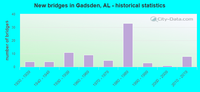
- New bridges - historical statistics
- 41930-1939
- 41940-1949
- 111950-1959
- 91960-1969
- 51970-1979
- 331980-1989
- 31990-1999
- 12000-2009
- 82010-2019
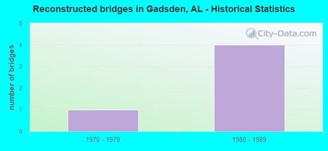
- Reconstructed bridges - Historical Statistics
- 11970-1979
- 41980-1989
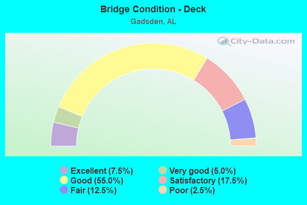
- Bridge Condition - Deck
- 7.5%Excellent
- 5.0%Very good
- 55.0%Good
- 17.5%Satisfactory
- 12.5%Fair
- 2.5%Poor
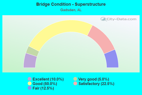
- Bridge Condition - Superstructure
- 10.0%Excellent
- 5.0%Very good
- 50.0%Good
- 22.5%Satisfactory
- 12.5%Fair
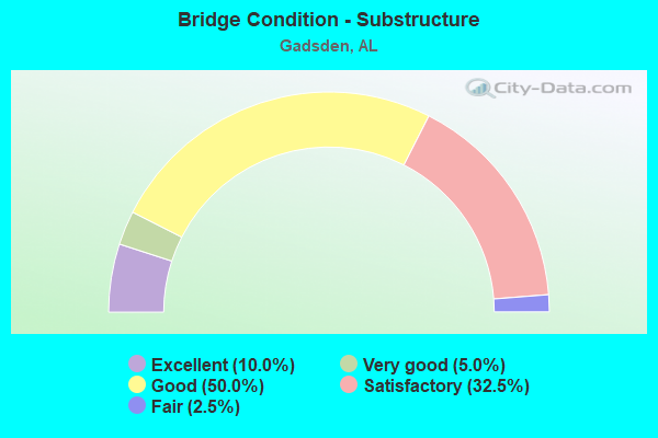
- Bridge Condition - Substructure
- 10.0%Excellent
- 5.0%Very good
- 50.0%Good
- 32.5%Satisfactory
- 2.5%Fair
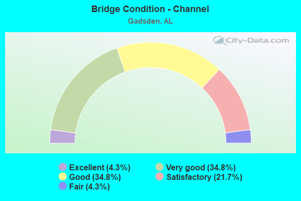
- Bridge Condition - Channel
- 4.3%Excellent
- 34.8%Very good
- 34.8%Good
- 21.7%Satisfactory
- 4.3%Fair

- Bridge Condition - Culverts
- 5.3%Excellent
- 21.1%Very good
- 36.8%Good
- 31.6%Satisfactory
- 5.3%Fair
Find on map >> Show street view
Structure Number: 13418, Location: N CITY LIMIT GADSDEN (Lat: 34.053294, Lng: -86.004250), Route carried "on" structure: County highway 300, Year Built: 1984, Status: Open, Structure Length: 1.95m (6.40ft), Average Daily Traffic: 400 (year 1991), Truck Traffic: 2%, Average Future Daily Traffic: 956 (year 2035), Design Load: HS 20, Features Intersected: BLACK CREEK, Facility Carried by Structure: DELMONT DR.
Minimum Vertical Clearance: 30+ m (98+ ft), Kilometerpoint: 0.010, Lanes on structure: 2, Owner: County Highway Agency, Approaching Roadway Width: 8.5m (27.9ft), Skew: 2 degrees, Material/Design: Concrete, Design/Construction: Culvert, Number Of Spans In Main Unit: 4, Length of Maximum Span: 4.9m (16.1ft), Curb-To-Curb Width: 8.5m (27.9ft), Out-to-Out Width: 8.5m (27.9ft)
Condition: Channel: Good, Culverts: Good, Operating Rating: 77.7 metric tons, Method Used To Determine Operating Rating: Load Factor (LF), Inventory Rating: 46.5 metric tons, Method Used To Determine Inventory Rating: Load Factor (LF), Structural Evaluation: Better than present minimum criteria, Deck Geometry: Equal to present minimum criteria, Waterway Adequacy: Better than present minimum criteria, Approach Roadway Alignment: Equal to present desirable criteria, Length Of Structure Improvement: 2.69m (8.83ft), Designated Inspection Frequency: Every 24 months, Inspection Date: April 2021, Bridge Improvement Cost: $963,000, Roadway Improvement Cost: $96,000, Total Project Cost: $1,059,000 ( Estimate for 2022)
Find on map >> Show street view
Structure Number: 13519, Location: I-759-EAST SIDE DR (Lat: 33.991583, Lng: -86.025139), Route carried "on" structure: Alternate County highway , Year Built: 1985, Status: Open, Structure Length: 9.09m (29.82ft), Average Daily Traffic: 308 (year 2019), Truck Traffic: 4%, Average Future Daily Traffic: 432 (year 2039), Design Load: HS 20, Features Intersected: I-759, Facility Carried by Structure: EAST SIDE DR
Minimum Vertical Clearance: 30.18m (99.02ft), Kilometerpoint: 0.010, Lanes on structure: 2, Lanes under structure: 4, Owner: State Highway Agency, Approaching Roadway Width: 13.4m (44.0ft), Material/Design: Steel continuous, Design/Construction: Stringer/Multi-beam, Number Of Spans In Main Unit: 4, Length of Maximum Span: 25.6m (84.0ft), Curb-To-Curb Width: 13.4m (44.0ft), Out-to-Out Width: 14.3m (46.9ft)
Condition: Deck: Good, Superstructure: Satisfactory, Substructure: Satisfactory, Operating Rating: 62.3 metric tons, Method Used To Determine Operating Rating: Load Factor (LF), Inventory Rating: 37.3 metric tons, Method Used To Determine Inventory Rating: Load Factor (LF), Structural Evaluation: Equal to present minimum criteria, Deck Geometry: Superior to present desirable criteria, Underclear: Somewhat better than minimum adequacy, Approach Roadway Alignment: Equal to present desirable criteria, Length Of Structure Improvement: 10.05m (32.97ft), Designated Inspection Frequency: Every 24 months, Inspection Date: January 2021, Bridge Improvement Cost: $3,171,000, Roadway Improvement Cost: $317,000, Total Project Cost: $3,488,000 ( Estimate for 2022), Deck Structure Type: Concrete Cast-file-Place
Find on map >> Show street view
Structure Number: 1352, Location: I 759 * BLACK CK (Lat: 33.991861, Lng: -86.015500), Route carried "on" structure: Spur Interstate 759, Year Built: 1985, Status: Open, Structure Length: 12.50m (41.01ft), Average Daily Traffic: 20,970 (year 2019), Truck Traffic: 9%, Average Future Daily Traffic: 29,358 (year 2039), Design Load: HS 20, Features Intersected: BLACK CREEK
Minimum Vertical Clearance: 30+ m (98+ ft), Kilometerpoint: 5.855, Lanes on structure: 2, Base Highway Network: Yes, Owner: State Highway Agency, Approaching Roadway Width: 18.3m (60.0ft), Material/Design: Prestressed concrete continuous, Design/Construction: Stringer/Multi-beam, Number Of Spans In Main Unit: 10, Length of Maximum Span: 12.5m (41.0ft), Curb-To-Curb Width: 12.2m (40.0ft), Out-to-Out Width: 13.1m (43.0ft)
Condition: Deck: Good, Superstructure: Good, Substructure: Good, Channel: Good, Operating Rating: 54.1 metric tons, Method Used To Determine Operating Rating: Load Factor (LF), Inventory Rating: 30.3 metric tons, Method Used To Determine Inventory Rating: Load Factor (LF), Structural Evaluation: Better than present minimum criteria, Deck Geometry: Better than present minimum criteria, Waterway Adequacy: Equal to present desirable criteria, Approach Roadway Alignment: Equal to present desirable criteria, Length Of Structure Improvement: 13.34m (43.77ft), Designated Inspection Frequency: Every 24 months, Underwater Inspection Frequency: Every 24 months, Inspection Date: Febuary 2021, Underwater Inspection Date: May 2020, Bridge Improvement Cost: $3,934,000, Roadway Improvement Cost: $393,000, Total Project Cost: $4,327,000 ( Estimate for 2022), Deck Structure Type: Concrete Cast-file-Place
Find on map >> Show street view
Structure Number: 13521, Location: I 759 * BLACK CREEK (Lat: 33.991583, Lng: -86.015778), Route carried "on" structure: Spur Interstate 759, Year Built: 1985, Status: Open, Structure Length: 12.50m (41.01ft), Average Daily Traffic: 13,236 (year 2019), Truck Traffic: 7%, Average Future Daily Traffic: 18,531 (year 2039), Design Load: HS 20, Features Intersected: BLACK CREEK
Minimum Vertical Clearance: 30+ m (98+ ft), Kilometerpoint: 5.855, Lanes on structure: 2, Base Highway Network: Yes, Owner: State Highway Agency, Approaching Roadway Width: 18.3m (60.0ft), Material/Design: Prestressed concrete continuous, Design/Construction: Stringer/Multi-beam, Number Of Spans In Main Unit: 10, Length of Maximum Span: 12.5m (41.0ft), Curb-To-Curb Width: 12.2m (40.0ft), Out-to-Out Width: 13.1m (43.0ft)
Condition: Deck: Good, Superstructure: Good, Substructure: Good, Channel: Good, Operating Rating: 69.1 metric tons, Method Used To Determine Operating Rating: Load Factor (LF), Inventory Rating: 42.0 metric tons, Method Used To Determine Inventory Rating: Load Factor (LF), Structural Evaluation: Better than present minimum criteria, Deck Geometry: Better than present minimum criteria, Waterway Adequacy: Equal to present desirable criteria, Approach Roadway Alignment: Equal to present desirable criteria, Length Of Structure Improvement: 13.34m (43.77ft), Designated Inspection Frequency: Every 24 months, Underwater Inspection Frequency: Every 24 months, Inspection Date: Febuary 2021, Underwater Inspection Date: May 2020, Bridge Improvement Cost: $3,934,000, Roadway Improvement Cost: $393,000, Total Project Cost: $4,327,000 ( Estimate for 2022), Deck Structure Type: Concrete Cast-file-Place
Find on map >> Show street view
Structure Number: 13522, Location: I-759-US-411 (Lat: 33.993056, Lng: -86.004083), Route carried "on" structure: Spur Interstate 759, Year Built: 1985, Status: Open, Structure Length: 9.72m (31.89ft), Average Daily Traffic: 10,485 (year 2019), Truck Traffic: 9%, Average Future Daily Traffic: 14,679 (year 2039), Design Load: HS 20, Features Intersected: US-411
Minimum Vertical Clearance: 30+ m (98+ ft), Kilometerpoint: 7.220, Lanes on structure: 3, Lanes under structure: 6, Base Highway Network: Yes, Owner: State Highway Agency, Approaching Roadway Width: 17.1m (56.1ft), Skew: 1 degrees, Material/Design: Steel continuous, Design/Construction: Stringer/Multi-beam, Number Of Spans In Main Unit: 3, Number Of Approach Spans: 1, Length of Maximum Span: 26.5m (86.9ft), Curb-To-Curb Width: 15.8m (51.8ft), Out-to-Out Width: 16.7m (54.8ft)
Condition: Deck: Good, Superstructure: Good, Substructure: Good, Operating Rating: 63.2 metric tons, Method Used To Determine Operating Rating: Load Factor (LF), Inventory Rating: 37.9 metric tons, Method Used To Determine Inventory Rating: Load Factor (LF), Structural Evaluation: Better than present minimum criteria, Deck Geometry: Somewhat better than minimum adequacy, Underclear: Equal to present desirable criteria, Approach Roadway Alignment: Equal to present desirable criteria, Length Of Structure Improvement: 10.66m (34.97ft), Designated Inspection Frequency: Every 24 months, Inspection Date: Febuary 2021, Bridge Improvement Cost: $3,948,000, Roadway Improvement Cost: $395,000, Total Project Cost: $4,343,000 ( Estimate for 2022), Deck Structure Type: Concrete Cast-file-Place
Find on map >> Show street view
Structure Number: 13523, Location: I-759-US-411 (Lat: 33.992583, Lng: -86.004389), Route carried "on" structure: Spur Interstate 759, Year Built: 1985, Status: Open, Structure Length: 9.72m (31.89ft), Average Daily Traffic: 26,472 (year 2019), Truck Traffic: 7%, Average Future Daily Traffic: 37,061 (year 2039), Design Load: HS 20, Features Intersected: US-411
Minimum Vertical Clearance: 30+ m (98+ ft), Kilometerpoint: 7.220, Lanes on structure: 2, Lanes under structure: 6, Base Highway Network: Yes, Owner: State Highway Agency, Approaching Roadway Width: 15.8m (51.8ft), Skew: 1 degrees, Material/Design: Steel continuous, Design/Construction: Stringer/Multi-beam, Number Of Spans In Main Unit: 4, Length of Maximum Span: 26.5m (86.9ft), Curb-To-Curb Width: 15.8m (51.8ft), Out-to-Out Width: 16.5m (54.1ft)
Condition: Deck: Good, Superstructure: Good, Substructure: Good, Operating Rating: 63.2 metric tons, Method Used To Determine Operating Rating: Load Factor (LF), Inventory Rating: 37.9 metric tons, Method Used To Determine Inventory Rating: Load Factor (LF), Structural Evaluation: Better than present minimum criteria, Deck Geometry: Superior to present desirable criteria, Underclear: Better than present minimum criteria, Approach Roadway Alignment: Equal to present desirable criteria, Length Of Structure Improvement: 10.66m (34.97ft), Designated Inspection Frequency: Every 24 months, Inspection Date: Febuary 2021, Bridge Improvement Cost: $3,948,000, Roadway Improvement Cost: $395,000, Total Project Cost: $4,343,000 ( Estimate for 2022), Deck Structure Type: Concrete Cast-file-Place
Find on map >> Show street view
Structure Number: 13524, Location: I 759 * BIG WILLS CK (Lat: 33.990500, Lng: -86.005028), Route carried "on" structure: Ramp Interstate 759, Year Built: 1985, Status: Open, Structure Length: 7.75m (25.43ft), Average Daily Traffic: 1,502 (year 2019), Truck Traffic: 6%, Average Future Daily Traffic: 2,103 (year 2039), Design Load: HS 20, Features Intersected: BIG WILLS CK
Minimum Vertical Clearance: 30+ m (98+ ft), Kilometerpoint: 7.220, Lanes on structure: 1, Base Highway Network: Yes, Owner: State Highway Agency, Approaching Roadway Width: 8.8m (28.9ft), Material/Design: Prestressed concrete continuous, Design/Construction: Stringer/Multi-beam, Number Of Spans In Main Unit: 4, Length of Maximum Span: 19.4m (63.6ft), Curb-To-Curb Width: 7.6m (24.9ft), Out-to-Out Width: 8.5m (27.9ft)
Condition: Deck: Good, Superstructure: Good, Substructure: Good, Channel: Very good, Operating Rating: 62.2 metric tons, Method Used To Determine Operating Rating: Load Factor (LF), Inventory Rating: 28.2 metric tons, Method Used To Determine Inventory Rating: Load Factor (LF), Structural Evaluation: Better than present minimum criteria, Deck Geometry: Better than present minimum criteria, Waterway Adequacy: Equal to present desirable criteria, Approach Roadway Alignment: Equal to present minimum criteria, Length Of Structure Improvement: 8.76m (28.74ft), Designated Inspection Frequency: Every 24 months, Underwater Inspection Frequency: Every 24 months, Inspection Date: Febuary 2021, Underwater Inspection Date: May 2020, Bridge Improvement Cost: $1,622,000, Roadway Improvement Cost: $162,000, Total Project Cost: $1,784,000 ( Estimate for 2022), Deck Structure Type: Concrete Cast-file-Place
Find on map >> Show street view
Structure Number: 13525, Location: I 759 * COOSA RIVER (Lat: 33.993567, Lng: -86.000739), Route carried "on" structure: Alternate Interstate 759, Year Built: 1985, Status: Open, Structure Length: 39.87m (130.81ft), Average Daily Traffic: 13,236 (year 2019), Truck Traffic: 7%, Average Future Daily Traffic: 18,530 (year 2039), Design Load: HS 20, Features Intersected: COOSA RIVER
Minimum Vertical Clearance: 30+ m (98+ ft), Kilometerpoint: 7.543, Lanes on structure: 2, Base Highway Network: Yes, Owner: State Highway Agency, Approaching Roadway Width: 15.8m (51.8ft), Navigation Control: Yes ( Vertical Clearance: 18.3m (60.0ft), Horizontal Clearance: 64.0m (210.0ft)), Material/Design: Steel, Design/Construction: Stringer/Multi-beam, Number Of Spans In Main Unit: 3, Number Of Approach Spans: 7, Length of Maximum Span: 67.1m (220.1ft), Curb-To-Curb Width: 12.2m (40.0ft), Out-to-Out Width: 15.6m (51.2ft)
Condition: Deck: Good, Superstructure: Good, Substructure: Good, Channel: Good, Operating Rating: 69.4 metric tons, Method Used To Determine Operating Rating: Load Factor (LF), Inventory Rating: 41.5 metric tons, Method Used To Determine Inventory Rating: Load Factor (LF), Structural Evaluation: Better than present minimum criteria, Deck Geometry: Somewhat better than minimum adequacy, Waterway Adequacy: Superior to present desirable criteria, Approach Roadway Alignment: Equal to present desirable criteria, Length Of Structure Improvement: 39.87m (130.81ft), Designated Inspection Frequency: Every 24 months, Underwater Inspection Frequency: Every 24 months, Inspection Date: June 2021, Underwater Inspection Date: May 2020, Bridge Improvement Cost: $13,943,000, Roadway Improvement Cost: $1,394,000, Total Project Cost: $15,337,000 ( Estimate for 2022), Deck Structure Type: Open Grating
Find on map >> Show street view
Structure Number: 13526, Location: I 759 * RIVER ROAD (Lat: 33.993256, Lng: -86.001525), Route carried "on" structure: Alternate Interstate 759, Year Built: 1985, Status: Open, Structure Length: 7.83m (25.69ft), Average Daily Traffic: 7,182 (year 2019), Truck Traffic: 3%, Average Future Daily Traffic: 10,055 (year 2039), Design Load: HS 20, Features Intersected: COOSA RIVER
Minimum Vertical Clearance: 30+ m (98+ ft), Kilometerpoint: 7.543, Lanes on structure: 1, Base Highway Network: Yes, Owner: State Highway Agency, Approaching Roadway Width: 8.8m (28.9ft), Material/Design: Steel continuous, Design/Construction: Stringer/Multi-beam, Number Of Spans In Main Unit: 3, Length of Maximum Span: 26.4m (86.6ft), Curb-To-Curb Width: 7.9m (25.9ft), Out-to-Out Width: 8.5m (27.9ft)
Condition: Deck: Good, Superstructure: Good, Substructure: Good, Channel: Very good, Operating Rating: 83.6 metric tons, Method Used To Determine Operating Rating: Load Factor (LF), Inventory Rating: 50.1 metric tons, Method Used To Determine Inventory Rating: Load Factor (LF), Structural Evaluation: Better than present minimum criteria, Deck Geometry: High priority of corrective action, Waterway Adequacy: Equal to present desirable criteria, Approach Roadway Alignment: Equal to present desirable criteria, Length Of Structure Improvement: 8.84m (29.00ft), Designated Inspection Frequency: Every 24 months, Inspection Date: Febuary 2021, Bridge Improvement Cost: $1,637,000, Roadway Improvement Cost: $164,000, Total Project Cost: $1,801,000 ( Estimate for 2022), Deck Structure Type: Concrete Cast-file-Place
Find on map >> Show street view
Structure Number: 13828, Location: U S 411 * BIG WILLS CK (Lat: 33.986667, Lng: -86.005000), Route carried "on" structure: US 411, Year Built: 1967, Year Reconstructed: 1985, Status: Open, Structure Length: 7.53m (24.70ft), Average Daily Traffic: 17,116 (year 2019), Truck Traffic: 4%, Average Future Daily Traffic: 23,963 (year 2039), Design Load: HS 20, Features Intersected: BIG WILLS CREEK
Minimum Vertical Clearance: 30+ m (98+ ft), Kilometerpoint: 347.940, Lanes on structure: 3, Base Highway Network: Yes, Owner: State Highway Agency, Approaching Roadway Width: 18.0m (59.1ft), Material/Design: Steel, Design/Construction: Stringer/Multi-beam, Number Of Spans In Main Unit: 3, Length of Maximum Span: 25.0m (82.0ft), Curb-To-Curb Width: 18.2m (59.7ft), Out-to-Out Width: 19.4m (63.6ft)
Condition: Deck: Satisfactory, Superstructure: Satisfactory, Substructure: Satisfactory, Channel: Satisfactory, Operating Rating: 71.0 metric tons, Method Used To Determine Operating Rating: Load Factor (LF), Inventory Rating: 42.5 metric tons, Method Used To Determine Inventory Rating: Load Factor (LF), Structural Evaluation: Equal to present minimum criteria, Deck Geometry: Superior to present desirable criteria, Waterway Adequacy: Equal to present minimum criteria, Approach Roadway Alignment: Equal to present desirable criteria, Length Of Structure Improvement: 8.55m (28.05ft), Designated Inspection Frequency: Every 24 months, Underwater Inspection Frequency: Every 24 months, Inspection Date: July 2021, Underwater Inspection Date: May 2020, Bridge Improvement Cost: $3,693,000, Roadway Improvement Cost: $369,000, Total Project Cost: $4,062,000 ( Estimate for 2022), Deck Structure Type: Concrete Cast-file-Place
Find on map >> Show street view
Structure Number: 17049, Location: AL 211 BLACK CREEK (Lat: 34.041667, Lng: -86.020000), Route carried "on" structure: State highway 211, Year Built: 1999, Status: Open, Structure Length: 2.07m (6.79ft), Average Daily Traffic: 12,802 (year 2019), Truck Traffic: 5%, Average Future Daily Traffic: 17,923 (year 2039), Design Load: HS 20, Features Intersected: BLACK CREEK
Minimum Vertical Clearance: 30+ m (98+ ft), Kilometerpoint: 2.766, Lanes on structure: 5, Owner: State Highway Agency, Approaching Roadway Width: 18.3m (60.0ft), Skew: 1 degrees, Material/Design: Concrete, Design/Construction: Culvert, Number Of Spans In Main Unit: 4, Length of Maximum Span: 4.8m (15.7ft), Curb or Sidewalk Widths: Left: 1.5m (4.9ft), Right: 1.5m (4.9ft)
Condition: Channel: Good, Culverts: Satisfactory, Operating Rating: 65.4 metric tons, Method Used To Determine Operating Rating: Load Factor (LF), Inventory Rating: 39.3 metric tons, Method Used To Determine Inventory Rating: Load Factor (LF), Structural Evaluation: Equal to present minimum criteria, Waterway Adequacy: Equal to present desirable criteria, Approach Roadway Alignment: Equal to present desirable criteria, Length Of Structure Improvement: 2.84m (9.32ft), Designated Inspection Frequency: Every 24 months, Inspection Date: June 2021, Bridge Improvement Cost: $1,313,000, Roadway Improvement Cost: $131,000, Total Project Cost: $1,444,000 ( Estimate for 2022)
Find on map >> Show street view
Structure Number: 17185, Location: 0.354 KM WEST OF US 431 (Lat: 33.972222, Lng: -85.955556), Route carried "on" structure: Bypass County highway 175, Year Built: 1974, Status: Open, Structure Length: 1.13m (3.71ft), Average Daily Traffic: 2,000 (year 2003), Truck Traffic: 2%, Average Future Daily Traffic: 2,900 (year 2034), Design Load: H 15, Features Intersected: HONEY CREEK, Facility Carried by Structure: COLLEGE PARKWAY
Minimum Vertical Clearance: 30+ m (98+ ft), Kilometerpoint: 0.352, Lanes on structure: 4, Owner: County Highway Agency, Approaching Roadway Width: 29.9m (98.1ft), Skew: 13 degrees, Material/Design: Concrete, Design/Construction: Culvert, Number Of Spans In Main Unit: 3, Length of Maximum Span: 3.7m (12.1ft)
Condition: Channel: Satisfactory, Culverts: Satisfactory, Operating Rating: 73.6 metric tons, Method Used To Determine Operating Rating: Load Factor (LF), Inventory Rating: 44.1 metric tons, Method Used To Determine Inventory Rating: Load Factor (LF), Structural Evaluation: Equal to present minimum criteria, Waterway Adequacy: Equal to present desirable criteria, Approach Roadway Alignment: Equal to present desirable criteria, Length Of Structure Improvement: 1.80m (5.91ft), Designated Inspection Frequency: Every 24 months, Inspection Date: October 2020, Bridge Improvement Cost: $1,653,000, Roadway Improvement Cost: $165,000, Total Project Cost: $1,818,000 ( Estimate for 2022), Wearing Surface/Protective System: Wearing Surface: Bituminous
Find on map >> Show street view
Structure Number: 18214, Location: I-759+COOSA RIVER (Lat: 33.993417, Lng: -86.002028), Route carried "on" structure: Alternate Interstate 759, Year Built: 2003, Status: Open, Structure Length: 39.87m (130.81ft), Average Daily Traffic: 12,958 (year 2018), Truck Traffic: 7%, Average Future Daily Traffic: 18,141 (year 2038), Design Load: HS 20, Features Intersected: COOSA RIVER
Minimum Vertical Clearance: 30+ m (98+ ft), Kilometerpoint: 7.543, Lanes on structure: 3, Base Highway Network: Yes, Owner: State Highway Agency, Approaching Roadway Width: 17.1m (56.1ft), Navigation Control: Yes ( Vertical Clearance: 16.8m (55.1ft), Horizontal Clearance: 64.0m (210.0ft)), Material/Design: Prestressed concrete, Design/Construction: Stringer/Multi-beam, Number Of Spans In Main Unit: 10, Length of Maximum Span: 39.6m (129.9ft), Curb-To-Curb Width: 17.1m (56.1ft), Out-to-Out Width: 17.7m (58.1ft)
Condition: Deck: Good, Superstructure: Good, Substructure: Good, Channel: Good, Operating Rating: 65.8 metric tons, Method Used To Determine Operating Rating: Load Factor (LF), Inventory Rating: 37.0 metric tons, Method Used To Determine Inventory Rating: Load Factor (LF), Structural Evaluation: Better than present minimum criteria, Deck Geometry: Equal to present minimum criteria, Waterway Adequacy: Equal to present desirable criteria, Approach Roadway Alignment: Equal to present desirable criteria, Length Of Structure Improvement: 39.87m (130.81ft), Designated Inspection Frequency: Every 24 months, Underwater Inspection Frequency: Every 24 months, Inspection Date: June 2020, Underwater Inspection Date: May 2020, Bridge Improvement Cost: $15,856,000, Roadway Improvement Cost: $1,586,000, Total Project Cost: $17,442,000 ( Estimate for 2022), Deck Structure Type: Concrete Cast-file-Place
Find on map >> Show street view
Structure Number: 20099, Location: CHESTNUT ST * BLACK CK (Lat: 34.025000, Lng: -86.042200), Route carried "on" structure: City street , Year Built: 2010, Status: Open, Structure Length: 4.57m (14.99ft), Average Daily Traffic: 5,500 (year 2020), Truck Traffic: 5%, Average Future Daily Traffic: 8,880 (year 2020), Design Load: HS 20, Features Intersected: BLACK CREEK, Facility Carried by Structure: CHESTNUT STREET
Minimum Vertical Clearance: 30+ m (98+ ft), Kilometerpoint: 2.120, Lanes on structure: 2, Owner: City or Municipal Highway Agency, Approaching Roadway Width: 7.3m (24.0ft), Material/Design: Steel, Design/Construction: Stringer/Multi-beam, Number Of Spans In Main Unit: 3, Length of Maximum Span: 15.5m (50.9ft), Curb-To-Curb Width: 8.5m (27.9ft), Out-to-Out Width: 9.4m (30.8ft)
Condition: Deck: Very good, Superstructure: Excellent, Substructure: Excellent, Channel: Excellent, Operating Rating: 61.6 metric tons, Method Used To Determine Operating Rating: Load Factor (LF), Inventory Rating: 36.8 metric tons, Method Used To Determine Inventory Rating: Load Factor (LF), Structural Evaluation: Superior to present desirable criteria, Deck Geometry: High priority of replacement, Waterway Adequacy: Superior to present desirable criteria, Approach Roadway Alignment: Equal to present desirable criteria, Length Of Structure Improvement: 5.57m (18.27ft), Designated Inspection Frequency: Every 24 months, Inspection Date: July 2020, Bridge Improvement Cost: $1,145,000, Roadway Improvement Cost: $115,000, Total Project Cost: $1,260,000 ( Estimate for 2022), Deck Structure Type: Concrete Cast-file-Place
Find on map >> Show street view
Structure Number: 2054, Location: @ Emma Sampson School (Lat: 34.024675, Lng: -86.032403), Route carried "on" structure: US 431, Year Built: 2017, Status: Open, Structure Length: 4.82m (15.81ft), Average Daily Traffic: 22,092 (year 2020), Truck Traffic: 8%, Average Future Daily Traffic: 30,929 (year 2040), Design Load: HS 20, Features Intersected: Black Creek
Minimum Vertical Clearance: 30+ m (98+ ft), Kilometerpoint: 422.837, Lanes on structure: 3, Base Highway Network: Yes, Owner: State Highway Agency, Approaching Roadway Width: 17.8m (58.4ft), Material/Design: Steel, Design/Construction: Stringer/Multi-beam, Number Of Spans In Main Unit: 3, Length of Maximum Span: 16.5m (54.1ft), Curb-To-Curb Width: 15.9m (52.2ft), Out-to-Out Width: 17.8m (58.4ft)
Condition: Deck: Good, Superstructure: Very good, Substructure: Good, Channel: Very good, Operating Rating: 88.9 metric tons, Method Used To Determine Operating Rating: Load Factor (LF), Inventory Rating: 55.9 metric tons, Method Used To Determine Inventory Rating: Load Factor (LF), Structural Evaluation: Better than present minimum criteria, Deck Geometry: Better than present minimum criteria, Waterway Adequacy: Equal to present desirable criteria, Approach Roadway Alignment: Equal to present desirable criteria, Length Of Structure Improvement: 5.82m (19.09ft), Designated Inspection Frequency: Every 24 months, Inspection Date: November 2021, Bridge Improvement Cost: $2,316,000, Roadway Improvement Cost: $232,000, Total Project Cost: $2,548,000 ( Estimate for 2022), Deck Structure Type: Concrete Cast-file-Place
Find on map >> Show street view
Structure Number: 20541, Location: @ Emma Sampson School (Lat: 34.024600, Lng: -86.032200), Route carried "on" structure: US 431, Year Built: 2017, Status: Open, Structure Length: 4.57m (14.99ft), Average Daily Traffic: 16,354 (year 2018), Truck Traffic: 10%, Average Future Daily Traffic: 22,895 (year 2038), Design Load: HS 20, Features Intersected: Black Creek
Minimum Vertical Clearance: 30+ m (98+ ft), Kilometerpoint: 422.837, Lanes on structure: 3, Base Highway Network: Yes, Owner: State Highway Agency, Approaching Roadway Width: 15.8m (51.8ft), Skew: 1 degrees, Material/Design: Steel, Design/Construction: Stringer/Multi-beam, Number Of Spans In Main Unit: 3, Number Of Approach Spans: 2, Length of Maximum Span: 16.5m (54.1ft), Curb or Sidewalk Widths: Left: 1.7m (5.6ft), Right: 0.0m, Curb-To-Curb Width: 13.6m (44.6ft), Out-to-Out Width: 18.3m (60.0ft)
Condition: Deck: Very good, Superstructure: Very good, Substructure: Very good, Channel: Very good, Operating Rating: 88.9 metric tons, Method Used To Determine Operating Rating: Load Factor (LF), Inventory Rating: 60.7 metric tons, Method Used To Determine Inventory Rating: Load Factor (LF), Structural Evaluation: Equal to present desirable criteria, Deck Geometry: Somewhat better than minimum adequacy, Waterway Adequacy: Equal to present desirable criteria, Approach Roadway Alignment: Superior to present desirable criteria, Length Of Structure Improvement: 5.57m (18.27ft), Designated Inspection Frequency: Every 24 months, Inspection Date: June 2020, Bridge Improvement Cost: $2,291,000, Roadway Improvement Cost: $229,000, Total Project Cost: $2,520,000 ( Estimate for 2022), Deck Structure Type: Concrete Cast-file-Place
Find on map >> Show street view
Structure Number: 20553, Location: AIRPORT ROAD (Lat: 33.980000, Lng: -86.078333), Route carried "on" structure: City street , Year Built: 2011, Status: Open, Structure Length: 1.37m (4.49ft), Average Daily Traffic: 500 (year 2021), Truck Traffic: 5%, Average Future Daily Traffic: 600 (year 2041), Design Load: HS 20, Features Intersected: U T TO BIG WILLS CREEK, Facility Carried by Structure: AIRPORT ROAD
Minimum Vertical Clearance: 30+ m (98+ ft), Kilometerpoint: 0.010, Lanes on structure: 4, Toll: Toll bridge is a segment, Owner: City or Municipal Highway Agency, Approaching Roadway Width: 14.6m (47.9ft), Material/Design: Concrete, Design/Construction: Culvert, Number Of Spans In Main Unit: 1, Length of Maximum Span: 13.7m (44.9ft), Curb or Sidewalk Widths: Left: 0.8m (2.6ft), Right: 0.8m (2.6ft), Curb-To-Curb Width: 13.9m (45.6ft), Out-to-Out Width: 18.3m (60.0ft)
Condition: Channel: Excellent, Culverts: Excellent, Operating Rating: 41.1 metric tons, Method Used To Determine Operating Rating: Load Factor (LF), Inventory Rating: 25.1 metric tons, Method Used To Determine Inventory Rating: Load Factor (LF), Structural Evaluation: Equal to present minimum criteria, Deck Geometry: High priority of replacement, Waterway Adequacy: Equal to present desirable criteria, Approach Roadway Alignment: Equal to present desirable criteria, Length Of Structure Improvement: 2.05m (6.73ft), Designated Inspection Frequency: Every 24 months, Inspection Date: August 2021, Bridge Improvement Cost: $709,000, Roadway Improvement Cost: $71,000, Total Project Cost: $780,000 ( Estimate for 2022), Deck Structure Type: Concrete Precast Panels, Wearing Surface/Protective System: Wearing Surface: Bituminous
Find on map >> Show street view
Structure Number: 20735, Location: Gadsden (Lat: 33.999328, Lng: -86.024322), Route carried "on" structure: City street , Year Built: 2016, Status: Open, Structure Length: 4.88m (16.01ft), Design Load: HS 20, Features Intersected: BLACK CREEK, Facility Carried by Structure: S 11TH STREET
Minimum Vertical Clearance: 30+ m (98+ ft), Kilometerpoint: 0.010, Lanes on structure: 2, Owner: City or Municipal Highway Agency, Approaching Roadway Width: 7.3m (24.0ft), Material/Design: Prestressed concrete, Design/Construction: Stringer/Multi-beam, Number Of Spans In Main Unit: 4, Length of Maximum Span: 12.2m (40.0ft), Curb or Sidewalk Widths: Left: 2.8m (9.2ft), Right: 0.0m, Curb-To-Curb Width: 12.1m (39.7ft), Out-to-Out Width: 12.1m (39.7ft)
Condition: Deck: Excellent, Superstructure: Excellent, Substructure: Excellent, Channel: Very good, Operating Rating: 66.0 metric tons, Method Used To Determine Operating Rating: Load Factor (LF), Inventory Rating: 39.6 metric tons, Method Used To Determine Inventory Rating: Load Factor (LF), Structural Evaluation: Superior to present desirable criteria, Deck Geometry: High priority of replacement, Approach Roadway Alignment: Equal to present desirable criteria, Length Of Structure Improvement: 5.89m (19.32ft), Designated Inspection Frequency: Every 24 months, Inspection Date: October 2020, Bridge Improvement Cost: $1,575,000, Roadway Improvement Cost: $158,000, Total Project Cost: $1,733,000 ( Estimate for 2022), Deck Structure Type: Concrete Cast-file-Place
Find on map >> Show street view
Structure Number: 20797, Location: Tuscaloosa Ave/Blk Crk (Lat: 34.028333, Lng: -86.018333), Route carried "on" structure: City street , Year Built: 2016, Status: Open, Structure Length: 2.59m (8.50ft), Truck Traffic: 1%, Design Load: HS 20, Features Intersected: Black Creek, Facility Carried by Structure: Tuscaloosa Avenue
Minimum Vertical Clearance: 0.00m, Kilometerpoint: 2.749, Lanes on structure: 2, Owner: City or Municipal Highway Agency, Approaching Roadway Width: 7.3m (24.0ft), Material/Design: Prestressed concrete, Design/Construction: Stringer/Multi-beam, Number Of Spans In Main Unit: 1, Length of Maximum Span: 25.9m (85.0ft), Curb-To-Curb Width: 9.4m (30.8ft), Out-to-Out Width: 9.4m (30.8ft)
Condition: Deck: Excellent, Superstructure: Excellent, Substructure: Excellent, Channel: Very good, Operating Rating: 88.9 metric tons, Method Used To Determine Operating Rating: Load Factor (LF), Inventory Rating: 62.8 metric tons, Method Used To Determine Inventory Rating: Load Factor (LF), Structural Evaluation: Superior to present desirable criteria, Deck Geometry: High priority of replacement, Approach Roadway Alignment: Meets minimum limits, Length Of Structure Improvement: 3.49m (11.45ft), Designated Inspection Frequency: Every 24 months, Inspection Date: December 2020, Bridge Improvement Cost: $718,000, Roadway Improvement Cost: $72,000, Total Project Cost: $790,000 ( Estimate for 2022), Deck Structure Type: Concrete Cast-file-Place
Find on map >> Show street view
Structure Number: 20984, Location: Hickory Street @ Black Ck (Lat: 34.008333, Lng: -86.030000), Route carried "on" structure: City street , Year Built: 2014, Status: Open, Structure Length: 1.92m (6.30ft), Average Daily Traffic: 1,500 (year 2020), Average Future Daily Traffic: 2,717 (year 2040), Design Load: HS 20, Features Intersected: Black Creek, Facility Carried by Structure: Hickory Street
Minimum Vertical Clearance: 0.00m, Kilometerpoint: 1.849, Lanes on structure: 2, Owner: City or Municipal Highway Agency, Approaching Roadway Width: 7.3m (24.0ft), Material/Design: Steel continuous, Design/Construction: Stringer/Multi-beam, Number Of Spans In Main Unit: 1, Length of Maximum Span: 19.2m (63.0ft), Curb-To-Curb Width: 7.3m (24.0ft), Out-to-Out Width: 8.5m (27.9ft)
Condition: Deck: Excellent, Superstructure: Excellent, Substructure: Excellent, Channel: Very good, Operating Rating: 36.4 metric tons, Method Used To Determine Operating Rating: Load Factor (LF), Inventory Rating: 21.8 metric tons, Method Used To Determine Inventory Rating: Load Factor (LF), Structural Evaluation: Somewhat better than minimum adequacy, Deck Geometry: High priority of corrective action, Approach Roadway Alignment: Better than present minimum criteria, Length Of Structure Improvement: 2.65m (8.69ft), Designated Inspection Frequency: Every 24 months, Inspection Date: December 2020, Bridge Improvement Cost: $509,000, Roadway Improvement Cost: $51,000, Total Project Cost: $560,000 ( Estimate for 2022), Deck Structure Type: Other, Wearing Surface/Protective System: Wearing Surface: Bituminous
Find on map >> Show street view
Structure Number: 4754, Location: US 431 * US 411 (Lat: 34.013142, Lng: -85.996158), Route carried "under" structure: US 411, Year Built: 1954, Structure Length: 0. m, Average Daily Traffic: 20,050 (year 2019), Truck Traffic: 6%, Features Intersected: COOSA RV * US 411, Facility Carried by Structure: US 431
Minimum Vertical Clearance: 6.27m (20.57ft), Kilometerpoint: 350.676, Lanes on structure: 4, Lanes under structure: 4, Material/Design: Steel continuous, Design/Construction: Stringer/Multi-beam, Length of Maximum Span: 48.8m (160.1ft)
Find on map >> Show street view
Structure Number: 5068, Location: .1 MI.SO.COOSA RIVER (Lat: 34.011728, Lng: -85.992903), Route carried "under" structure: US 431, Year Built: 1955, Structure Length: 0. m, Average Daily Traffic: 14,420 (year 2019), Truck Traffic: 10%, Features Intersected: LAKE STREET
Minimum Vertical Clearance: 3.96m (12.99ft), Kilometerpoint: 0.161, Lanes on structure: 4, Lanes under structure: 2, Toll: Toll bridge is a segment, Material/Design: Concrete continuous, Design/Construction: Tee Beam, Length of Maximum Span: 14.6m (47.9ft)
Find on map >> Show street view
Structure Number: 7765, Location: AL 77 * I 59 (Lat: 33.997081, Lng: -86.086772), Route carried "under" structure: Interstate 59, Year Built: 1962, Structure Length: 0. m, Average Daily Traffic: 32,563 (year 2020), Truck Traffic: 30%, Features Intersected: I 59, Facility Carried by Structure: AL 77
Minimum Vertical Clearance: 5.24m (17.19ft), Kilometerpoint: 291.776, Lanes on structure: 2, Lanes under structure: 4, Material/Design: Concrete continuous, Design/Construction: Tee Beam, Length of Maximum Span: 25.9m (85.0ft)
Find on map >> Show street view
Structure Number: 8901, Location: AL 211 * I59 (Lat: 34.072989, Lng: -86.025831), Route carried "under" structure: Interstate 59, Year Built: 1965, Structure Length: 0. m, Average Daily Traffic: 16,282 (year 2020), Truck Traffic: 30%, Features Intersected: I59, Facility Carried by Structure: AL 211
Minimum Vertical Clearance: 5.33m (17.49ft), Kilometerpoint: 302.689, Lanes on structure: 2, Lanes under structure: 4, Material/Design: Concrete continuous, Design/Construction: Tee Beam, Length of Maximum Span: 29.9m (98.1ft)
Find on map >> Show street view
Structure Number: 10073, Location: AL 77 * I 59 (Lat: 33.996897, Lng: -86.086825), Route carried "under" structure: Interstate 59, Year Built: 1969, Structure Length: 0. m, Average Daily Traffic: 32,563 (year 2020), Truck Traffic: 30%, Features Intersected: I 59, Facility Carried by Structure: AL 77
Minimum Vertical Clearance: 5.39m (17.68ft), Kilometerpoint: 291.776, Lanes on structure: 2, Lanes under structure: 4, Material/Design: Concrete continuous, Design/Construction: Tee Beam, Length of Maximum Span: 25.9m (85.0ft)
Find on map >> Show street view
Structure Number: 10434, Location: 700' FROM U.S. 431 (Lat: 33.966667, Lng: -86.983333), Route carried "under" structure: State highway 291, Year Built: 1970, Structure Length: 0. m, Average Daily Traffic: 20,419 (year 2019), Truck Traffic: 3%, Features Intersected: AL 291, Facility Carried by Structure: CSX RR
Minimum Vertical Clearance: 4.42m (14.50ft), Kilometerpoint: 1.127, Lanes under structure: 4, Material/Design: Steel, Design/Construction: Girder and Floorbeam System, Length of Maximum Span: 15.8m (51.8ft)
Find on map >> Show street view
Structure Number: 10566, Location: L*N RR *U.S. 411 (Lat: 34.011747, Lng: -85.997836), Route carried "under" structure: Other road 411, Year Built: 1971, Structure Length: 0. m, Average Daily Traffic: 32,746 (year 2019), Truck Traffic: 7%, Features Intersected: US 411, Facility Carried by Structure: L&N RR
Minimum Vertical Clearance: 5.85m (19.19ft), Kilometerpoint: 217.590, Lanes under structure: 4, Material/Design: Steel, Design/Construction: Stringer/Multi-beam, Length of Maximum Span: 18.3m (60.0ft)
Find on map >> Show street view
Structure Number: 13159, Location: I 759 * I 59 INTR (Lat: 34.006039, Lng: -86.081742), Route carried "under" structure: Interstate 59, Year Built: 1984, Structure Length: 0. m, Average Daily Traffic: 26,726 (year 2019), Truck Traffic: 24%, Features Intersected: I 59 SBL
Minimum Vertical Clearance: 5.41m (17.75ft), Kilometerpoint: 292.994, Lanes on structure: 2, Lanes under structure: 3, Material/Design: Prestressed concrete continuous, Design/Construction: Stringer/Multi-beam, Length of Maximum Span: 36.6m (120.1ft)
Find on map >> Show street view
Structure Number: 1316, Location: RAMP B OVER I59 (Lat: 34.007656, Lng: -86.077528), Route carried "under" structure: Interstate 59, Year Built: 1984, Structure Length: 0. m, Average Daily Traffic: 28,610 (year 2019), Truck Traffic: 25%, Features Intersected: I 59 NBL *
Minimum Vertical Clearance: 4.94m (16.21ft), Kilometerpoint: 293.123, Lanes on structure: 1, Lanes under structure: 2, Material/Design: Steel continuous, Design/Construction: Stringer/Multi-beam, Length of Maximum Span: 29.0m (95.1ft)
Find on map >> Show street view
Structure Number: 13162, Location: I 759 * I59 INTR (Lat: 34.005658, Lng: -86.079078), Route carried "under" structure: Interstate 59, Year Built: 1984, Structure Length: 0. m, Average Daily Traffic: 22,834 (year 2019), Truck Traffic: 24%, Features Intersected: I 59 NBL
Minimum Vertical Clearance: 5.70m (18.70ft), Kilometerpoint: 292.996, Lanes on structure: 2, Lanes under structure: 2, Material/Design: Prestressed concrete continuous, Design/Construction: Stringer/Multi-beam, Length of Maximum Span: 36.3m (119.1ft)
Find on map >> Show street view
Structure Number: 13163, Location: I 759 * BROOK AVE (Lat: 34.004417, Lng: -86.069167), Route carried "under" structure: Spur City street , Year Built: 1984, Structure Length: 0. m, Average Daily Traffic: 2,950 (year 2019), Truck Traffic: 6%, Features Intersected: BROOK AVE * BIG WILLS CK, Facility Carried by Structure: I 759
Minimum Vertical Clearance: 8.08m (26.51ft), Kilometerpoint: 0.000, Lanes on structure: 2, Lanes under structure: 2, Material/Design: Prestressed concrete continuous, Design/Construction: Stringer/Multi-beam, Length of Maximum Span: 24.4m (80.1ft)
Find on map >> Show street view
Structure Number: 13164, Location: I 759 * BROOK AVE (Lat: 34.004472, Lng: -86.071361), Route carried "under" structure: Spur City street , Year Built: 1984, Structure Length: 0. m, Average Daily Traffic: 2,951 (year 2019), Truck Traffic: 6%, Features Intersected: BROOK AV, Facility Carried by Structure: I 759
Minimum Vertical Clearance: 7.72m (25.33ft), Kilometerpoint: 0.000, Lanes on structure: 2, Lanes under structure: 2, Material/Design: Prestressed concrete continuous, Design/Construction: Stringer/Multi-beam, Length of Maximum Span: 24.4m (80.1ft)
Find on map >> Show street view
Structure Number: 13167, Location: I 759 * BLK CK PKWAY (Lat: 33.992056, Lng: -86.037556), Route carried "under" structure: Alternate County highway , Year Built: 1984, Structure Length: 0. m, Average Daily Traffic: 2,700 (year 2019), Truck Traffic: 6%, Features Intersected: BLACK CK PARKWAY, Facility Carried by Structure: I 759
Minimum Vertical Clearance: 5.06m (16.60ft), Kilometerpoint: 0.000, Lanes on structure: 2, Lanes under structure: 6, Material/Design: Steel, Design/Construction: Stringer/Multi-beam, Length of Maximum Span: 36.6m (120.1ft)
Find on map >> Show street view
Structure Number: 13168, Location: I 759 * BLK CK PKWAY (Lat: 33.991778, Lng: -86.038139), Route carried "under" structure: Alternate County highway , Year Built: 1984, Structure Length: 0. m, Average Daily Traffic: 14,629 (year 2019), Truck Traffic: 2%, Features Intersected: BLACK CREEK PARKWAY, Facility Carried by Structure: I 759
Minimum Vertical Clearance: 5.12m (16.80ft), Kilometerpoint: 0.000, Lanes on structure: 2, Lanes under structure: 6, Material/Design: Steel, Design/Construction: Stringer/Multi-beam, Length of Maximum Span: 36.6m (120.1ft)
Find on map >> Show street view
Structure Number: 13519, Location: I-759-EAST SIDE DR (Lat: 33.991583, Lng: -86.025139), Route carried "under" structure: Spur Interstate 759, Year Built: 1985, Structure Length: 0. m, Average Daily Traffic: 26,472 (year 2019), Truck Traffic: 7%, Features Intersected: I-759, Facility Carried by Structure: EAST SIDE DR
Minimum Vertical Clearance: 4.94m (16.21ft), Kilometerpoint: 5.354, Lanes on structure: 2, Lanes under structure: 4, Material/Design: Steel continuous, Design/Construction: Stringer/Multi-beam, Length of Maximum Span: 25.6m (84.0ft)
Find on map >> Show street view
Structure Number: 13522, Location: I-759-US-411 (Lat: 33.993056, Lng: -86.004083), Route carried "under" structure: US 411, Year Built: 1985, Structure Length: 0. m, Average Daily Traffic: 30,171 (year 2019), Truck Traffic: 3%, Features Intersected: US-411, Facility Carried by Structure: I-759
Minimum Vertical Clearance: 5.18m (16.99ft), Kilometerpoint: 348.322, Lanes on structure: 3, Lanes under structure: 6, Material/Design: Steel continuous, Design/Construction: Stringer/Multi-beam, Length of Maximum Span: 26.5m (86.9ft)
Find on map >> Show street view
Structure Number: 13523, Location: I-759-US-411 (Lat: 33.992583, Lng: -86.004389), Route carried "under" structure: US 411, Year Built: 1985, Structure Length: 0. m, Average Daily Traffic: 34,232 (year 2019), Truck Traffic: 4%, Features Intersected: US-411, Facility Carried by Structure: I-759
Minimum Vertical Clearance: 4.97m (16.31ft), Kilometerpoint: 348.322, Lanes on structure: 2, Lanes under structure: 6, Material/Design: Steel continuous, Design/Construction: Stringer/Multi-beam, Length of Maximum Span: 26.5m (86.9ft)
Find on map >> Show street view
Structure Number: 15967, Location: 1/4 M EAST OF JCT.278+431 (Lat: 33.990000, Lng: -85.966667), Route carried "under" structure: US 278, Year Built: 1994, Structure Length: 0. m, Average Daily Traffic: 15,273 (year 2019), Truck Traffic: 6%, Features Intersected: U.S.278, Facility Carried by Structure: PEDESTRIAN OVERPAS
Minimum Vertical Clearance: 5.52m (18.11ft), Kilometerpoint: 217.422, Lanes under structure: 3, Material/Design: Steel, Design/Construction: Stringer/Multi-beam, Length of Maximum Span: 20.7m (67.9ft)
Find on map >> Show street view
Structure Number: 21487, Location: _US HWY 431 @ EMMA SAMP (Lat: 34.025000, Lng: -86.033333), Route carried "under" structure: US 431, Year Built: 2018, Structure Length: 0. m, Average Daily Traffic: 22,092 (year 2019), Truck Traffic: 8%, Features Intersected: _US HWY 431, Facility Carried by Structure: _PEDESTRIAN
Minimum Vertical Clearance: 5.76m (18.90ft), Kilometerpoint: 422.984, Lanes under structure: 6, Material/Design: Steel, Design/Construction: Girder and Floorbeam System, Length of Maximum Span: 41.0m (134.5ft)