Bridge Statistics for Gary, Indiana (IN)
Condition, Traffic, Stress, Structural Evaluation, Project Costs
- National Bridge Inventory (NBI) Statistics
- 309Number of bridges
- 4,803ft / 1,464mTotal length
- $5,207,000Total costs
- 7,885,081Total average daily traffic
- 1,587,602Total average daily truck traffic
- National Bridge Inventory (NBI) Registered Bridges for Gary
- No street view available for this location
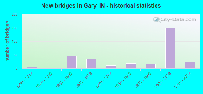
- New bridges - historical statistics
- 11920-1929
- 51930-1939
- 451950-1959
- 361960-1969
- 111970-1979
- 191980-1989
- 181990-1999
- 1512000-2009
- 232010-2019
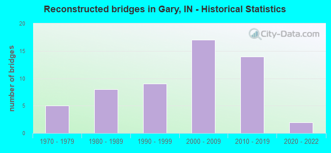
- Reconstructed bridges - Historical Statistics
- 51970-1979
- 81980-1989
- 91990-1999
- 172000-2009
- 142010-2019
- 22020-2022
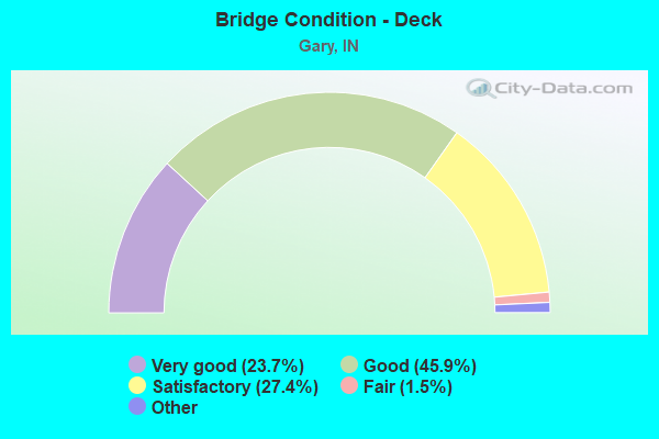
- Bridge Condition - Deck
- 23.7%Very good
- 45.9%Good
- 27.4%Satisfactory
- 1.5%Fair
- 1.5%Poor
- 0.7%Serious
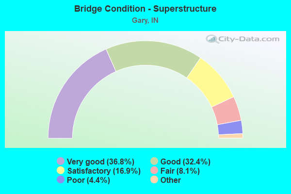
- Bridge Condition - Superstructure
- 36.8%Excellent
- 32.4%Very good
- 16.9%Good
- 8.1%Satisfactory
- 4.4%Fair
- 1.5%Poor
- 0.7%Serious
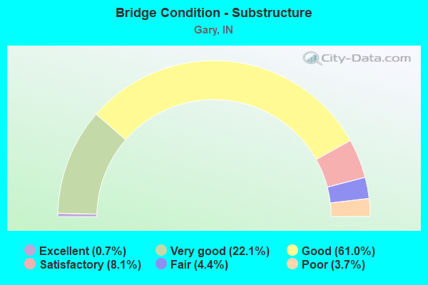
- Bridge Condition - Substructure
- 0.7%Excellent
- 22.1%Very good
- 61.0%Good
- 8.1%Satisfactory
- 4.4%Fair
- 3.7%Poor
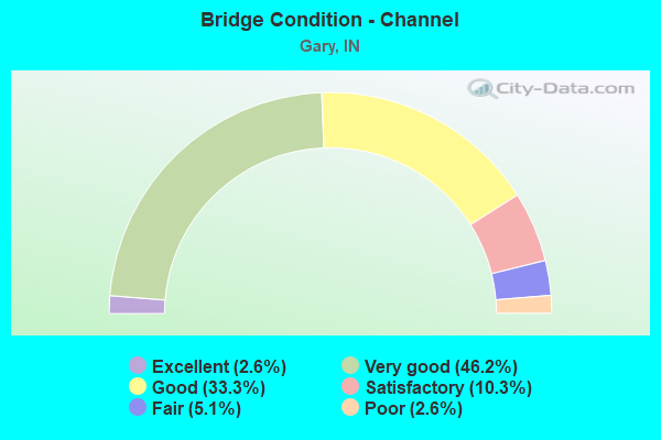
- Bridge Condition - Channel
- 2.6%Excellent
- 46.2%Very good
- 33.3%Good
- 10.3%Satisfactory
- 5.1%Fair
- 2.6%Poor
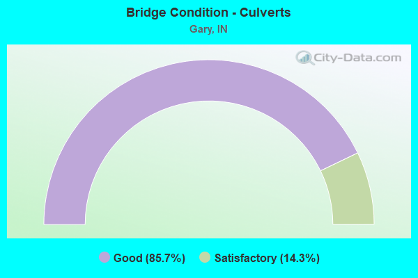
- Bridge Condition - Culverts
- 85.7%Good
- 14.3%Satisfactory
Find on map >> Show street view
Structure Number: 45599, Location: 02.52 E US 41 (Lat: 41.570300, Lng: -87.432411), Route carried "on" structure: Ramp Interstate 80, Year Built: 2001, Status: Open, Structure Length: 7.10m (23.29ft), Average Daily Traffic: 185,778 (year 2021), Truck Traffic: 30%, Average Future Daily Traffic: 7,666 (year 2030), Design Load: HS 20, Features Intersected: SR 912 EB/WB, RAMPS
Minimum Vertical Clearance: 30+ m (98+ ft), Kilometerpoint: 7.886, Lanes on structure: 1, Lanes under structure: 9, Base Highway Network: Yes (, Subroute: 1), Owner: State Highway Agency, Approaching Roadway Width: 11.0m (36.1ft), Material/Design: Steel continuous, Design/Construction: Stringer/Multi-beam, Number Of Spans In Main Unit: 4, Length of Maximum Span: 19.1m (62.7ft), Curb-To-Curb Width: 10.9m (35.8ft), Out-to-Out Width: 11.7m (38.4ft)
Condition: Deck: Good, Superstructure: Very good, Substructure: Satisfactory, Operating Rating: 83.2 metric tons, Method Used To Determine Operating Rating: Load Factor (LF), Inventory Rating: 49.8 metric tons, Method Used To Determine Inventory Rating: Load Factor (LF), Structural Evaluation: Equal to present minimum criteria, Deck Geometry: Superior to present desirable criteria, Underclear: Equal to present minimum criteria, Approach Roadway Alignment: Equal to present desirable criteria, Designated Inspection Frequency: Every 24 months, Inspection Date: March 2022, Deck Structure Type: Concrete Cast-file-Place, Wearing Surface/Protective System: Wearing Surface: Epoxy Overlay, Deck Protection: Epoxy Coated Reinforcing
Find on map >> Show street view
Structure Number: 456, Location: 02.53 E US 41 (Lat: 41.570061, Lng: -87.432469), Route carried "on" structure: Interstate 80, Year Built: 2001, Status: Open, Structure Length: 7.13m (23.39ft), Average Daily Traffic: 141,800 (year 2020), Truck Traffic: 24%, Average Future Daily Traffic: 183,840 (year 2030), Design Load: HS 20, Features Intersected: SR 912 EB/WB, RAMPS
Minimum Vertical Clearance: 30+ m (98+ ft), Kilometerpoint: 7.902, Lanes on structure: 8, Lanes under structure: 9, Base Highway Network: Yes (, Subroute: 1), Owner: State Highway Agency, Approaching Roadway Width: 43.3m (142.1ft), Skew: 30 degrees, Material/Design: Steel continuous, Design/Construction: Stringer/Multi-beam, Number Of Spans In Main Unit: 4, Length of Maximum Span: 19.1m (62.7ft), Curb-To-Curb Width: 43.6m (143.0ft), Out-to-Out Width: 45.1m (148.0ft)
Condition: Deck: Good, Superstructure: Good, Substructure: Good, Operating Rating: 82.1 metric tons, Method Used To Determine Operating Rating: Load Factor (LF), Inventory Rating: 49.2 metric tons, Method Used To Determine Inventory Rating: Load Factor (LF), Structural Evaluation: Better than present minimum criteria, Deck Geometry: Superior to present desirable criteria, Underclear: Equal to present minimum criteria, Approach Roadway Alignment: Equal to present desirable criteria, Designated Inspection Frequency: Every 24 months, Inspection Date: March 2022, Deck Structure Type: Concrete Cast-file-Place, Wearing Surface/Protective System: Wearing Surface: Monolithic Concrete, Deck Protection: Epoxy Coated Reinforcing
Find on map >> Show street view
Structure Number: 45601, Location: 02.54 E US 41 (Lat: 41.569811, Lng: -87.432500), Route carried "on" structure: Ramp Interstate 80, Year Built: 2001, Status: Open, Structure Length: 7.13m (23.39ft), Average Daily Traffic: 8,345 (year 2020), Truck Traffic: 20%, Average Future Daily Traffic: 7,666 (year 2030), Design Load: HS 20, Features Intersected: SR 912 EB/WB, RAMPS
Minimum Vertical Clearance: 30+ m (98+ ft), Kilometerpoint: 7.918, Lanes on structure: 2, Lanes under structure: 9, Base Highway Network: Yes (, Subroute: 1), Owner: State Highway Agency, Approaching Roadway Width: 13.4m (44.0ft), Material/Design: Steel continuous, Design/Construction: Stringer/Multi-beam, Number Of Spans In Main Unit: 4, Length of Maximum Span: 19.1m (62.7ft), Curb-To-Curb Width: 13.3m (43.6ft), Out-to-Out Width: 14.2m (46.6ft)
Condition: Deck: Satisfactory, Superstructure: Good, Substructure: Satisfactory, Operating Rating: 74.9 metric tons, Method Used To Determine Operating Rating: Load Factor (LF), Inventory Rating: 44.8 metric tons, Method Used To Determine Inventory Rating: Load Factor (LF), Structural Evaluation: Equal to present minimum criteria, Deck Geometry: Superior to present desirable criteria, Underclear: Equal to present minimum criteria, Approach Roadway Alignment: Equal to present desirable criteria, Designated Inspection Frequency: Every 24 months, Inspection Date: March 2022, Deck Structure Type: Concrete Cast-file-Place, Wearing Surface/Protective System: Wearing Surface: Monolithic Concrete, Deck Protection: Epoxy Coated Reinforcing
Find on map >> Show street view
Structure Number: 45605, Location: 00.50 E SR 912 (Lat: 41.569669, Lng: -87.423050), Route carried "on" structure: Ramp Interstate 80, Year Built: 1999, Status: Open, Structure Length: 12.07m (39.60ft), Average Daily Traffic: 13,118 (year 2020), Truck Traffic: 11%, Average Future Daily Traffic: 219 (year 2030), Design Load: HS 20+Mod, Features Intersected: N&S RR, EJ&E RR
Minimum Vertical Clearance: 30+ m (98+ ft), Kilometerpoint: 8.707, Lanes on structure: 2, Base Highway Network: Yes (, Subroute: 1), Owner: State Highway Agency, Approaching Roadway Width: 13.1m (43.0ft), Skew: 9 degrees, Material/Design: Steel continuous, Design/Construction: Stringer/Multi-beam, Number Of Spans In Main Unit: 4, Length of Maximum Span: 35.8m (117.5ft), Curb-To-Curb Width: 13.4m (44.0ft), Out-to-Out Width: 14.1m (46.3ft)
Condition: Deck: Satisfactory, Superstructure: Good, Substructure: Good, Operating Rating: 28.2 metric tons, Method Used To Determine Operating Rating: Load and Resistance Factor Rating (LRFR) rating reported by rating factor(RF) method using HL-93 loadings, Inventory Rating: 21.7 metric tons, Method Used To Determine Inventory Rating: Load and Resistance Factor Rating (LRFR) rating reported by rating factor(RF) method using HL-93 loadings, Structural Evaluation: Somewhat better than minimum adequacy, Deck Geometry: Superior to present desirable criteria, Underclear: Meets minimum limits, Approach Roadway Alignment: Equal to present desirable criteria, Designated Inspection Frequency: Every 24 months, Inspection Date: March 2022, Deck Structure Type: Concrete Cast-file-Place, Wearing Surface/Protective System: Wearing Surface: Latex Concrete, Deck Protection: Epoxy Coated Reinforcing
Find on map >> Show street view
Structure Number: 4561, Location: 00.50 E SR 912 (Lat: 41.569839, Lng: -87.423069), Route carried "on" structure: Interstate 80, Year Built: 1953, Year Reconstructed: 1999, Status: Open, Structure Length: 14.17m (46.49ft), Average Daily Traffic: 99,921 (year 2020), Truck Traffic: 34%, Average Future Daily Traffic: 191,585 (year 2030), Design Load: HS 20+Mod, Features Intersected: N&S RR, EJ&E RR, SPUR
Minimum Vertical Clearance: 30+ m (98+ ft), Kilometerpoint: 8.707, Lanes on structure: 3, Base Highway Network: Yes (, Subroute: 1), Owner: State Highway Agency, Approaching Roadway Width: 21.6m (70.9ft), Skew: 9 degrees, Material/Design: Steel continuous, Design/Construction: Stringer/Multi-beam, Number Of Spans In Main Unit: 12, Length of Maximum Span: 21.7m (71.2ft), Curb-To-Curb Width: 21.7m (71.2ft), Out-to-Out Width: 22.5m (73.8ft)
Condition: Deck: Satisfactory, Superstructure: Satisfactory, Substructure: Poor, Operating Rating: 47.6 metric tons, Method Used To Determine Operating Rating: Load and Resistance Factor Rating (LRFR) rating reported by rating factor(RF) method using HL-93 loadings, Inventory Rating: 36.9 metric tons, Method Used To Determine Inventory Rating: Load and Resistance Factor Rating (LRFR) rating reported by rating factor(RF) method using HL-93 loadings, Structural Evaluation: Meets minimum limits, Deck Geometry: Superior to present desirable criteria, Underclear: Meets minimum limits, Approach Roadway Alignment: Equal to present desirable criteria, Designated Inspection Frequency: Every 12 months, Inspection Date: March 2022, Deck Structure Type: Concrete Cast-file-Place, Wearing Surface/Protective System: Wearing Surface: Latex Concrete, Deck Protection: Epoxy Coated Reinforcing
Find on map >> Show street view
Structure Number: 4562, Location: 00.50 E SR 912 (Lat: 41.570039, Lng: -87.423050), Route carried "on" structure: Interstate 80, Year Built: 1953, Year Reconstructed: 1999, Status: Open, Structure Length: 16.64m (54.59ft), Average Daily Traffic: 91,049 (year 2021), Truck Traffic: 31%, Average Future Daily Traffic: 191,585 (year 2030), Design Load: HS 20+Mod, Features Intersected: N&S RR, EJ&E RR, SPUR
Minimum Vertical Clearance: 30+ m (98+ ft), Kilometerpoint: 8.707, Lanes on structure: 3, Base Highway Network: Yes (, Subroute: 1), Owner: State Highway Agency, Approaching Roadway Width: 21.6m (70.9ft), Skew: 9 degrees, Material/Design: Steel continuous, Design/Construction: Stringer/Multi-beam, Number Of Spans In Main Unit: 15, Length of Maximum Span: 21.7m (71.2ft), Curb-To-Curb Width: 21.7m (71.2ft), Out-to-Out Width: 22.5m (73.8ft)
Condition: Deck: Satisfactory, Superstructure: Good, Substructure: Fair, Operating Rating: 52.2 metric tons, Method Used To Determine Operating Rating: Load and Resistance Factor Rating (LRFR) rating reported by rating factor(RF) method using HL-93 loadings, Inventory Rating: 40.2 metric tons, Method Used To Determine Inventory Rating: Load and Resistance Factor Rating (LRFR) rating reported by rating factor(RF) method using HL-93 loadings, Structural Evaluation: Somewhat better than minimum adequacy, Deck Geometry: Superior to present desirable criteria, Underclear: Meets minimum limits, Approach Roadway Alignment: Equal to present desirable criteria, Designated Inspection Frequency: Every 24 months, Inspection Date: March 2022, Deck Structure Type: Concrete Cast-file-Place, Wearing Surface/Protective System: Wearing Surface: Latex Concrete, Deck Protection: Epoxy Coated Reinforcing
Find on map >> Show street view
Structure Number: 45625, Location: 00.50 E SR 912 (Lat: 41.570200, Lng: -87.423019), Route carried "on" structure: Ramp Interstate 80, Year Built: 1999, Status: Open, Structure Length: 19.57m (64.21ft), Average Daily Traffic: 20,081 (year 2020), Truck Traffic: 13%, Average Future Daily Traffic: 219 (year 2030), Design Load: HS 20+Mod, Features Intersected: N&S RR, EJ&E RR
Minimum Vertical Clearance: 30+ m (98+ ft), Kilometerpoint: 8.707, Lanes on structure: 2, Base Highway Network: Yes (, Subroute: 1), Owner: State Highway Agency, Approaching Roadway Width: 13.1m (43.0ft), Skew: 9 degrees, Material/Design: Steel continuous, Design/Construction: Stringer/Multi-beam, Number Of Spans In Main Unit: 6, Length of Maximum Span: 37.6m (123.4ft), Curb-To-Curb Width: 13.4m (44.0ft), Out-to-Out Width: 14.2m (46.6ft)
Condition: Deck: Satisfactory, Superstructure: Good, Substructure: Good, Operating Rating: 32.1 metric tons, Method Used To Determine Operating Rating: Load and Resistance Factor Rating (LRFR) rating reported by rating factor(RF) method using HL-93 loadings, Inventory Rating: 24.9 metric tons, Method Used To Determine Inventory Rating: Load and Resistance Factor Rating (LRFR) rating reported by rating factor(RF) method using HL-93 loadings, Structural Evaluation: Equal to present minimum criteria, Deck Geometry: Superior to present desirable criteria, Underclear: Meets minimum limits, Approach Roadway Alignment: Equal to present desirable criteria, Designated Inspection Frequency: Every 24 months, Inspection Date: March 2022, Deck Structure Type: Concrete Cast-file-Place, Wearing Surface/Protective System: Wearing Surface: Monolithic Concrete, Deck Protection: Epoxy Coated Reinforcing
Find on map >> Show street view
Structure Number: 4563, Location: 01.02 E SR 912 (Lat: 41.569939, Lng: -87.413100), Route carried "on" structure: Alternate City street , Year Built: 1994, Status: Open, Structure Length: 6.31m (20.70ft), Average Daily Traffic: 7,832 (year 2006), Truck Traffic: 5%, Average Future Daily Traffic: 11,035 (year 2030), Design Load: HS 20, Features Intersected: I-80/I-94 EB/WB, Facility Carried by Structure: COLFAX STREET
Minimum Vertical Clearance: 30+ m (98+ ft), Kilometerpoint: 0.000, Lanes on structure: 2, Lanes under structure: 10, Owner: State Highway Agency, Approaching Roadway Width: 10.4m (34.1ft), Material/Design: Steel continuous, Design/Construction: Stringer/Multi-beam, Number Of Spans In Main Unit: 2, Length of Maximum Span: 31.2m (102.4ft), Curb or Sidewalk Widths: Left: 1.5m (4.9ft), Right: 0.0m, Curb-To-Curb Width: 10.4m (34.1ft), Out-to-Out Width: 12.8m (42.0ft)
Condition: Deck: Satisfactory, Superstructure: Good, Substructure: Fair, Operating Rating: 33.0 metric tons, Method Used To Determine Operating Rating: Load and Resistance Factor Rating (LRFR) rating reported by rating factor(RF) method using HL-93 loadings, Inventory Rating: 25.3 metric tons, Method Used To Determine Inventory Rating: Load and Resistance Factor Rating (LRFR) rating reported by rating factor(RF) method using HL-93 loadings, Structural Evaluation: Somewhat better than minimum adequacy, Deck Geometry: Meets minimum limits, Underclear: Equal to present minimum criteria, Approach Roadway Alignment: Equal to present desirable criteria, Designated Inspection Frequency: Every 24 months, Inspection Date: March 2022, Deck Structure Type: Concrete Cast-file-Place, Wearing Surface/Protective System: Wearing Surface: Monolithic Concrete, Deck Protection: Epoxy Coated Reinforcing
Find on map >> Show street view
Structure Number: 4564, Location: 01.51 E SR 912 (Lat: 41.569881, Lng: -87.403300), Route carried "on" structure: City street , Year Built: 2000, Status: Open, Structure Length: 6.80m (22.31ft), Average Daily Traffic: 16,643 (year 2021), Truck Traffic: 23%, Average Future Daily Traffic: 53,430 (year 2030), Design Load: HS 20, Features Intersected: I-80 EB/WB, RAMP, Facility Carried by Structure: BURR STREET
Minimum Vertical Clearance: 30+ m (98+ ft), Kilometerpoint: 0.000, Lanes on structure: 6, Lanes under structure: 8, Owner: State Highway Agency, Approaching Roadway Width: 25.9m (85.0ft), Skew: 20 degrees, Material/Design: Steel continuous, Design/Construction: Stringer/Multi-beam, Number Of Spans In Main Unit: 2, Length of Maximum Span: 36.0m (118.1ft), Curb or Sidewalk Widths: Left: 1.6m (5.2ft), Right: 0.0m, Curb-To-Curb Width: 25.7m (84.3ft), Out-to-Out Width: 34.3m (112.5ft)
Condition: Deck: Satisfactory, Superstructure: Good, Substructure: Satisfactory, Operating Rating: 51.2 metric tons, Method Used To Determine Operating Rating: Load and Resistance Factor Rating (LRFR) rating reported by rating factor(RF) method using HL-93 loadings, Inventory Rating: 39.5 metric tons, Method Used To Determine Inventory Rating: Load and Resistance Factor Rating (LRFR) rating reported by rating factor(RF) method using HL-93 loadings, Structural Evaluation: Equal to present minimum criteria, Deck Geometry: Somewhat better than minimum adequacy, Underclear: Equal to present minimum criteria, Approach Roadway Alignment: Equal to present desirable criteria, Designated Inspection Frequency: Every 24 months, Inspection Date: March 2022, Deck Structure Type: Concrete Cast-file-Place, Wearing Surface/Protective System: Wearing Surface: Monolithic Concrete, Deck Protection: Epoxy Coated Reinforcing
Find on map >> Show street view
Structure Number: 4565, Location: 02.02 E SR 912 (Lat: 41.569850, Lng: -87.393861), Route carried "on" structure: Alternate City street , Year Built: 2002, Status: Open, Structure Length: 6.68m (21.92ft), Average Daily Traffic: 3,822 (year 2021), Truck Traffic: 7%, Average Future Daily Traffic: 44,466 (year 2030), Design Load: HS 20, Features Intersected: I-80 EB/WB, Facility Carried by Structure: CLARK STREET
Minimum Vertical Clearance: 30+ m (98+ ft), Kilometerpoint: 0.000, Lanes on structure: 4, Lanes under structure: 10, Owner: State Highway Agency, Approaching Roadway Width: 17.1m (56.1ft), Skew: 20 degrees, Material/Design: Prestressed concrete continuous, Design/Construction: Tee Beam, Number Of Spans In Main Unit: 2, Length of Maximum Span: 33.3m (109.3ft), Curb or Sidewalk Widths: Left: 2.0m (6.6ft), Right: 2.0m (6.6ft), Curb-To-Curb Width: 17.1m (56.1ft), Out-to-Out Width: 23.1m (75.8ft)
Condition: Deck: Good, Superstructure: Good, Substructure: Very good, Operating Rating: 49.6 metric tons, Method Used To Determine Operating Rating: Load and Resistance Factor Rating (LRFR) rating reported by rating factor(RF) method using HL-93 loadings, Inventory Rating: 38.2 metric tons, Method Used To Determine Inventory Rating: Load and Resistance Factor Rating (LRFR) rating reported by rating factor(RF) method using HL-93 loadings, Structural Evaluation: Better than present minimum criteria, Deck Geometry: Somewhat better than minimum adequacy, Underclear: Equal to present minimum criteria, Approach Roadway Alignment: Equal to present desirable criteria, Designated Inspection Frequency: Every 24 months, Inspection Date: March 2022, Deck Structure Type: Concrete Cast-file-Place, Wearing Surface/Protective System: Wearing Surface: Epoxy Overlay, Deck Protection: Epoxy Coated Reinforcing
Find on map >> Show street view
Structure Number: 45671, Location: 00.99 W SR 53 (Lat: 41.566011, Lng: -87.356019), Route carried "on" structure: Other road 80, Year Built: 1999, Status: Open, Structure Length: 2.62m (8.60ft), Average Daily Traffic: 34,298 (year 2004), Truck Traffic: 5%, Average Future Daily Traffic: 48,325 (year 2030), Design Load: HS 20, Features Intersected: LITTLE CALUMET RIVER, Facility Carried by Structure: GRANT STEET
Minimum Vertical Clearance: 30+ m (98+ ft), Kilometerpoint: 14.323, Lanes on structure: 6, Base Highway Network: Yes (, Subroute: 1), Owner: State Highway Agency, Approaching Roadway Width: 34.4m (112.9ft), Skew: 20 degrees, Material/Design: Concrete continuous, Design/Construction: Slab, Number Of Spans In Main Unit: 3, Length of Maximum Span: 10.1m (33.1ft), Curb or Sidewalk Widths: Left: 2.0m (6.6ft), Right: 2.0m (6.6ft), Curb-To-Curb Width: 28.6m (93.8ft), Out-to-Out Width: 34.6m (113.5ft)
Condition: Deck: Satisfactory, Superstructure: Satisfactory, Substructure: Satisfactory, Channel: Good, Operating Rating: 53.8 metric tons, Method Used To Determine Operating Rating: Load and Resistance Factor Rating (LRFR) rating reported by rating factor(RF) method using HL-93 loadings, Inventory Rating: 41.5 metric tons, Method Used To Determine Inventory Rating: Load and Resistance Factor Rating (LRFR) rating reported by rating factor(RF) method using HL-93 loadings, Structural Evaluation: Equal to present minimum criteria, Deck Geometry: Better than present minimum criteria, Waterway Adequacy: Equal to present desirable criteria, Approach Roadway Alignment: Equal to present desirable criteria, Designated Inspection Frequency: Every 24 months, Inspection Date: April 2020, Deck Structure Type: Concrete Cast-file-Place, Wearing Surface/Protective System: Wearing Surface: Monolithic Concrete, Deck Protection: Epoxy Coated Reinforcing
Find on map >> Show street view
Structure Number: 4568, Location: 00.48 W SR 53 (Lat: 41.567650, Lng: -87.346361), Route carried "on" structure: Alternate City street , Year Built: 2002, Status: Open, Structure Length: 6.71m (22.01ft), Average Daily Traffic: 14,720 (year 2004), Truck Traffic: 5%, Average Future Daily Traffic: 20,740 (year 2030), Design Load: HS 20, Features Intersected: I-80 EB/WB, Facility Carried by Structure: HARRISON STREET
Minimum Vertical Clearance: 30+ m (98+ ft), Kilometerpoint: 0.000, Lanes on structure: 4, Lanes under structure: 10, Owner: State Highway Agency, Approaching Roadway Width: 17.1m (56.1ft), Skew: 20 degrees, Material/Design: Prestressed concrete continuous, Design/Construction: Tee Beam, Number Of Spans In Main Unit: 2, Length of Maximum Span: 33.5m (109.9ft), Curb or Sidewalk Widths: Left: 2.0m (6.6ft), Right: 2.0m (6.6ft), Curb-To-Curb Width: 17.1m (56.1ft), Out-to-Out Width: 23.1m (75.8ft)
Condition: Deck: Good, Superstructure: Good, Substructure: Good, Operating Rating: 58.6 metric tons, Method Used To Determine Operating Rating: Load and Resistance Factor Rating (LRFR) rating reported by rating factor(RF) method using HL-93 loadings, Inventory Rating: 38.9 metric tons, Method Used To Determine Inventory Rating: Load and Resistance Factor Rating (LRFR) rating reported by rating factor(RF) method using HL-93 loadings, Structural Evaluation: Better than present minimum criteria, Deck Geometry: Somewhat better than minimum adequacy, Underclear: Equal to present minimum criteria, Approach Roadway Alignment: Equal to present desirable criteria, Designated Inspection Frequency: Every 24 months, Inspection Date: April 2020, Deck Structure Type: Concrete Cast-file-Place, Wearing Surface/Protective System: Wearing Surface: Epoxy Overlay, Deck Protection: Epoxy Coated Reinforcing
Find on map >> Show street view
Structure Number: 45685, Location: 00.07 S I-80 (Lat: 41.566350, Lng: -87.327050), Route carried "on" structure: City street , Year Built: 1996, Status: Open, Structure Length: 1.49m (4.89ft), Average Daily Traffic: 7,373 (year 2004), Truck Traffic: 5%, Average Future Daily Traffic: 14,687 (year 2030), Design Load: HS 20, Features Intersected: LITTLE CALUMET RIVER, Facility Carried by Structure: GEORGIA STREET
Minimum Vertical Clearance: 30+ m (98+ ft), Kilometerpoint: 16.721, Lanes on structure: 4, Owner: State Highway Agency, Approaching Roadway Width: 17.1m (56.1ft), Skew: 20 degrees, Material/Design: Concrete, Design/Construction: Culvert, Number Of Spans In Main Unit: 4, Length of Maximum Span: 2.4m (7.9ft), Curb-To-Curb Width: 17.1m (56.1ft), Out-to-Out Width: 17.1m (56.1ft)
Condition: Channel: Good, Culverts: Good, Operating Rating: 54.5 metric tons, Method Used To Determine Operating Rating: Field evaluation and documented engineering judgment, Inventory Rating: 32.7 metric tons, Method Used To Determine Inventory Rating: Field evaluation and documented engineering judgment, Structural Evaluation: Better than present minimum criteria, Deck Geometry: Somewhat better than minimum adequacy, Waterway Adequacy: Better than present minimum criteria, Approach Roadway Alignment: Equal to present desirable criteria, Designated Inspection Frequency: Every 24 months, Underwater Inspection Frequency: Every 60 months, Inspection Date: April 2020, Underwater Inspection Date: July 2019
Find on map >> Show street view
Structure Number: 45695, Location: 00.59 E SR 53 (Lat: 41.567389, Lng: -87.325189), Route carried "on" structure: Interstate 80, Year Built: 1996, Status: Open, Structure Length: 1.28m (4.20ft), Average Daily Traffic: 181,670 (year 2004), Truck Traffic: 5%, Average Future Daily Traffic: 361,886 (year 2030), Design Load: HS 20, Features Intersected: LITTLE CALUMET RIVER
Minimum Vertical Clearance: 30+ m (98+ ft), Kilometerpoint: 16.866, Lanes on structure: 6, Base Highway Network: Yes (, Subroute: 1), Owner: State Highway Agency, Approaching Roadway Width: 35.1m (115.2ft), Skew: 30 degrees, Material/Design: Concrete, Design/Construction: Culvert, Number Of Spans In Main Unit: 4, Length of Maximum Span: 2.4m (7.9ft), Curb-To-Curb Width: 35.1m (115.2ft), Out-to-Out Width: 38.7m (127.0ft)
Condition: Channel: Good, Culverts: Good, Operating Rating: 54.5 metric tons, Method Used To Determine Operating Rating: Field evaluation and documented engineering judgment, Inventory Rating: 32.7 metric tons, Method Used To Determine Inventory Rating: Field evaluation and documented engineering judgment, Structural Evaluation: Better than present minimum criteria, Deck Geometry: Superior to present desirable criteria, Waterway Adequacy: Better than present minimum criteria, Approach Roadway Alignment: Equal to present desirable criteria, Designated Inspection Frequency: Every 24 months, Underwater Inspection Frequency: Every 60 months, Inspection Date: April 2020, Underwater Inspection Date: July 2019
Find on map >> Show street view
Structure Number: 4582, Location: 00.38 W I-90 (Lat: 41.586111, Lng: -87.231461), Route carried "on" structure: Interstate 80, Year Built: 1963, Year Reconstructed: 2014, Status: Open, Structure Length: 8.65m (28.38ft), Average Daily Traffic: 14,469 (year 2015), Truck Traffic: 36%, Average Future Daily Traffic: 82,216 (year 2031), Design Load: HS 20, Features Intersected: I-94 EB/WB, 2RAMPS
Minimum Vertical Clearance: 30+ m (98+ ft), Kilometerpoint: 33.378, Lanes on structure: 2, Lanes under structure: 8, Base Highway Network: Yes (, Subroute: 1), Toll: On toll road, Owner: State Toll Authority, Approaching Roadway Width: 13.7m (44.9ft), Skew: 30 degrees, Material/Design: Steel continuous, Design/Construction: Stringer/Multi-beam, Number Of Spans In Main Unit: 4, Length of Maximum Span: 21.5m (70.5ft), Curb-To-Curb Width: 14.4m (47.2ft), Out-to-Out Width: 16.1m (52.8ft)
Condition: Deck: Very good, Superstructure: Very good, Substructure: Good, Operating Rating: 65.3 metric tons, Method Used To Determine Operating Rating: Load Factor (LF), Inventory Rating: 39.1 metric tons, Method Used To Determine Inventory Rating: Load Factor (LF), Structural Evaluation: Better than present minimum criteria, Deck Geometry: Superior to present desirable criteria, Underclear: Meets minimum limits, Approach Roadway Alignment: Equal to present desirable criteria, Designated Inspection Frequency: Every 24 months, Inspection Date: July 2021, Deck Structure Type: Concrete Cast-file-Place, Wearing Surface/Protective System: Wearing Surface: Monolithic Concrete, Deck Protection: Epoxy Coated Reinforcing
Find on map >> Show street view
Structure Number: 4583, Location: 00.31 W I-90 (Lat: 41.585619, Lng: -87.234017), Route carried "on" structure: Ramp Interstate 80, Year Built: 1966, Year Reconstructed: 1993, Status: Open, Structure Length: 4.57m (14.99ft), Average Daily Traffic: 3,429 (year 2004), Truck Traffic: 5%, Average Future Daily Traffic: 6,830 (year 2030), Design Load: HS 20+Mod, Features Intersected: RAMP M (I-90 TO WB I-80)
Minimum Vertical Clearance: 30+ m (98+ ft), Kilometerpoint: 25.074, Lanes on structure: 1, Lanes under structure: 1, Base Highway Network: Yes (, Subroute: 1), Owner: State Highway Agency, Approaching Roadway Width: 9.1m (29.9ft), Skew: 3 degrees, Material/Design: Prestressed concrete continuous, Design/Construction: Stringer/Multi-beam, Number Of Spans In Main Unit: 3, Length of Maximum Span: 17.1m (56.1ft), Curb-To-Curb Width: 7.4m (24.3ft), Out-to-Out Width: 8.2m (26.9ft)
Condition: Deck: Satisfactory, Superstructure: Fair, Substructure: Fair, Operating Rating: 39.5 metric tons, Method Used To Determine Operating Rating: Load and Resistance Factor Rating (LRFR) rating reported by rating factor(RF) method using HL-93 loadings, Inventory Rating: 30.5 metric tons, Method Used To Determine Inventory Rating: Load and Resistance Factor Rating (LRFR) rating reported by rating factor(RF) method using HL-93 loadings, Structural Evaluation: Somewhat better than minimum adequacy, Deck Geometry: Better than present minimum criteria, Underclear: Somewhat better than minimum adequacy, Approach Roadway Alignment: Equal to present desirable criteria, Designated Inspection Frequency: Every 24 months, Inspection Date: April 2020, Deck Structure Type: Concrete Cast-file-Place, Wearing Surface/Protective System: Wearing Surface: Latex Concrete
Find on map >> Show street view
Structure Number: 4584, Location: 00.04 W I-90 (Lat: 41.589250, Lng: -87.233092), Route carried "on" structure: Interstate 80, Year Built: 1963, Year Reconstructed: 2018, Status: Open, Structure Length: 5.21m (17.09ft), Average Daily Traffic: 19,778 (year 2015), Truck Traffic: 39%, Average Future Daily Traffic: 164,430 (year 2031), Design Load: HS 20+Mod, Features Intersected: BURNS DITCH/DEEP RIVER
Minimum Vertical Clearance: 30+ m (98+ ft), Kilometerpoint: 33.378, Lanes on structure: 6, Base Highway Network: Yes (, Subroute: 1), Toll: On toll road, Owner: State Toll Authority, Approaching Roadway Width: 31.1m (102.0ft), Skew: 20 degrees, Material/Design: Prestressed concrete, Design/Construction: Stringer/Multi-beam, Number Of Spans In Main Unit: 3, Length of Maximum Span: 17.1m (56.1ft), Curb or Sidewalk Widths: Left: 1.1m (3.6ft), Right: 1.1m (3.6ft), Curb-To-Curb Width: 23.4m (76.8ft), Out-to-Out Width: 27.5m (90.2ft)
Condition: Deck: Very good, Superstructure: Satisfactory, Substructure: Good, Channel: Very good, Operating Rating: 54.5 metric tons, Method Used To Determine Operating Rating: Load Factor (LF), Inventory Rating: 32.7 metric tons, Method Used To Determine Inventory Rating: Load Factor (LF), Structural Evaluation: Equal to present minimum criteria, Deck Geometry: High priority of replacement, Waterway Adequacy: Better than present minimum criteria, Approach Roadway Alignment: Equal to present desirable criteria, Designated Inspection Frequency: Every 24 months, Inspection Date: July 2021, Deck Structure Type: Concrete Cast-file-Place, Wearing Surface/Protective System: Wearing Surface: Monolithic Concrete, Deck Protection: Epoxy Coated Reinforcing
Find on map >> Show street view
Structure Number: 46275, Location: 00.53 N I-90 (Lat: 41.617650, Lng: -87.426156), Route carried "on" structure: Ramp Interstate 90, Year Built: 1984, Status: Open, Structure Length: 6.61m (21.69ft), Average Daily Traffic: 2,692 (year 2014), Truck Traffic: 20%, Average Future Daily Traffic: 15,075 (year 2031), Design Load: HS 20, Features Intersected: EJ&E RR
Minimum Vertical Clearance: 30+ m (98+ ft), Kilometerpoint: 15.868, Lanes on structure: 2, Base Highway Network: Yes (, Subroute: 1), Toll: On toll road, Owner: State Toll Authority, Approaching Roadway Width: 13.7m (44.9ft), Skew: 3 degrees, Material/Design: Steel, Design/Construction: Stringer/Multi-beam, Number Of Spans In Main Unit: 3, Length of Maximum Span: 25.0m (82.0ft), Curb or Sidewalk Widths: Left: 0.2m (0.7ft), Right: 0.2m (0.7ft), Curb-To-Curb Width: 12.3m (40.4ft), Out-to-Out Width: 13.3m (43.6ft)
Condition: Deck: Satisfactory, Superstructure: Poor, Substructure: Good, Operating Rating: 72.8 metric tons, Method Used To Determine Operating Rating: Load Factor (LF), Inventory Rating: 43.6 metric tons, Method Used To Determine Inventory Rating: Load Factor (LF), Structural Evaluation: Meets minimum limits, Deck Geometry: Superior to present desirable criteria, Underclear: Superior to present desirable criteria, Approach Roadway Alignment: Equal to present desirable criteria, Designated Inspection Frequency: Every 12 months, Other Special Inspection Frequency: Every 12 months, Inspection Date: July 2021, Other Special Inspection Date: July 2021, Deck Structure Type: Concrete Cast-file-Place, Wearing Surface/Protective System: Wearing Surface: Latex Concrete
Find on map >> Show street view
Structure Number: 46276, Location: 00.53 N I-90 (Lat: 41.617769, Lng: -87.426047), Route carried "on" structure: Ramp Interstate 90, Year Built: 1984, Status: Open, Structure Length: 6.61m (21.69ft), Average Daily Traffic: 3,228 (year 2014), Truck Traffic: 16%, Average Future Daily Traffic: 15,075 (year 2031), Design Load: HS 20, Features Intersected: EJ&E RR
Minimum Vertical Clearance: 30+ m (98+ ft), Kilometerpoint: 15.868, Lanes on structure: 2, Base Highway Network: Yes (, Subroute: 1), Toll: On toll road, Owner: State Toll Authority, Approaching Roadway Width: 13.7m (44.9ft), Skew: 3 degrees, Material/Design: Steel, Design/Construction: Stringer/Multi-beam, Number Of Spans In Main Unit: 3, Length of Maximum Span: 25.0m (82.0ft), Curb or Sidewalk Widths: Left: 0.2m (0.7ft), Right: 0.2m (0.7ft), Curb-To-Curb Width: 12.3m (40.4ft), Out-to-Out Width: 13.3m (43.6ft)
Condition: Deck: Satisfactory, Superstructure: Poor, Substructure: Good, Operating Rating: 72.9 metric tons, Method Used To Determine Operating Rating: Load Factor (LF), Inventory Rating: 43.7 metric tons, Method Used To Determine Inventory Rating: Load Factor (LF), Structural Evaluation: Meets minimum limits, Deck Geometry: Superior to present desirable criteria, Underclear: Superior to present desirable criteria, Approach Roadway Alignment: Equal to present desirable criteria, Designated Inspection Frequency: Every 12 months, Inspection Date: July 2021, Deck Structure Type: Concrete Cast-file-Place, Wearing Surface/Protective System: Wearing Surface: Latex Concrete
Find on map >> Show street view
Structure Number: 4628, Location: 00.50 E SR 912 (Lat: 41.609831, Lng: -87.423072), Route carried "on" structure: Interstate 90, Year Built: 1956, Year Reconstructed: 1988, Status: Open, Structure Length: 6.58m (21.59ft), Average Daily Traffic: 17,316 (year 2011), Truck Traffic: 14%, Average Future Daily Traffic: 41,903 (year 2031), Design Load: HS 20, Features Intersected: EJ&E RR
Minimum Vertical Clearance: 5.03m (16.50ft), Kilometerpoint: 16.110, Lanes on structure: 2, Base Highway Network: Yes (, Subroute: 1), Toll: On toll road, Owner: State Toll Authority, Approaching Roadway Width: 12.8m (42.0ft), Material/Design: Steel, Design/Construction: Stringer/Multi-beam, Number Of Spans In Main Unit: 3, Length of Maximum Span: 25.0m (82.0ft), Curb-To-Curb Width: 11.9m (39.0ft), Out-to-Out Width: 12.8m (42.0ft)
Condition: Deck: Satisfactory, Superstructure: Fair, Substructure: Fair, Operating Rating: 78.9 metric tons, Method Used To Determine Operating Rating: Load Factor (LF), Inventory Rating: 47.2 metric tons, Method Used To Determine Inventory Rating: Load Factor (LF), Structural Evaluation: Somewhat better than minimum adequacy, Deck Geometry: Equal to present minimum criteria, Underclear: Somewhat better than minimum adequacy, Approach Roadway Alignment: Equal to present desirable criteria, Designated Inspection Frequency: Every 24 months, Other Special Inspection Frequency: Every 24 months, Inspection Date: July 2021, Other Special Inspection Date: July 2021, Deck Structure Type: Concrete Cast-file-Place, Wearing Surface/Protective System: Wearing Surface: Latex Concrete
Find on map >> Show street view
Structure Number: 4629, Location: 00.50 E SR 912 (Lat: 41.609950, Lng: -87.423072), Route carried "on" structure: Interstate 90, Year Built: 1956, Year Reconstructed: 1988, Status: Open, Structure Length: 6.58m (21.59ft), Average Daily Traffic: 15,083 (year 2011), Truck Traffic: 14%, Average Future Daily Traffic: 41,903 (year 2031), Design Load: HS 20, Features Intersected: EJ&E RR
Minimum Vertical Clearance: 5.03m (16.50ft), Kilometerpoint: 16.110, Lanes on structure: 2, Base Highway Network: Yes (, Subroute: 1), Toll: On toll road, Owner: State Toll Authority, Approaching Roadway Width: 12.8m (42.0ft), Material/Design: Steel, Design/Construction: Stringer/Multi-beam, Number Of Spans In Main Unit: 3, Length of Maximum Span: 25.0m (82.0ft), Curb-To-Curb Width: 11.9m (39.0ft), Out-to-Out Width: 12.8m (42.0ft)
Condition: Deck: Satisfactory, Superstructure: Fair, Substructure: Fair, Operating Rating: 78.9 metric tons, Method Used To Determine Operating Rating: Load Factor (LF), Inventory Rating: 47.2 metric tons, Method Used To Determine Inventory Rating: Load Factor (LF), Structural Evaluation: Somewhat better than minimum adequacy, Deck Geometry: Equal to present minimum criteria, Underclear: Somewhat better than minimum adequacy, Approach Roadway Alignment: Equal to present minimum criteria, Designated Inspection Frequency: Every 24 months, Other Special Inspection Frequency: Every 24 months, Inspection Date: July 2021, Other Special Inspection Date: July 2021, Deck Structure Type: Concrete Cast-file-Place, Wearing Surface/Protective System: Wearing Surface: Latex Concrete
Find on map >> Show street view
Structure Number: 46291, Location: 00.47 N I-90 (Lat: 41.616489, Lng: -87.423133), Route carried "on" structure: Ramp Interstate 90, Year Built: 1984, Status: Open, Structure Length: 8.29m (27.20ft), Average Daily Traffic: 2,692 (year 2014), Truck Traffic: 20%, Average Future Daily Traffic: 15,075 (year 2031), Design Load: HS 20, Features Intersected: EJ&E RR
Minimum Vertical Clearance: 30+ m (98+ ft), Kilometerpoint: 16.126, Lanes on structure: 2, Base Highway Network: Yes (, Subroute: 1), Toll: On toll road, Owner: State Toll Authority, Approaching Roadway Width: 13.1m (43.0ft), Skew: 3 degrees, Material/Design: Steel, Design/Construction: Stringer/Multi-beam, Number Of Spans In Main Unit: 3, Length of Maximum Span: 32.3m (106.0ft), Curb or Sidewalk Widths: Left: 0.2m (0.7ft), Right: 0.2m (0.7ft), Curb-To-Curb Width: 12.3m (40.4ft), Out-to-Out Width: 13.3m (43.6ft)
Condition: Deck: Satisfactory, Superstructure: Poor, Substructure: Good, Operating Rating: 61.6 metric tons, Method Used To Determine Operating Rating: Load Factor (LF), Inventory Rating: 36.9 metric tons, Method Used To Determine Inventory Rating: Load Factor (LF), Structural Evaluation: Meets minimum limits, Deck Geometry: Superior to present desirable criteria, Underclear: Equal to present desirable criteria, Approach Roadway Alignment: Equal to present desirable criteria, Designated Inspection Frequency: Every 12 months, Inspection Date: July 2021, Deck Structure Type: Concrete Cast-file-Place, Wearing Surface/Protective System: Wearing Surface: Latex Concrete
Find on map >> Show street view
Structure Number: 46292, Location: 00.47 N I-90 (Lat: 41.616739, Lng: -87.423119), Route carried "on" structure: Ramp Interstate 90, Year Built: 1984, Status: Open, Structure Length: 8.29m (27.20ft), Average Daily Traffic: 3,228 (year 2014), Truck Traffic: 16%, Average Future Daily Traffic: 15,075 (year 2031), Design Load: HS 20, Features Intersected: EJ&E RR
Minimum Vertical Clearance: 30+ m (98+ ft), Kilometerpoint: 16.126, Lanes on structure: 2, Base Highway Network: Yes (, Subroute: 1), Toll: On toll road, Owner: State Toll Authority, Approaching Roadway Width: 13.1m (43.0ft), Skew: 3 degrees, Material/Design: Steel, Design/Construction: Stringer/Multi-beam, Number Of Spans In Main Unit: 3, Length of Maximum Span: 32.3m (106.0ft), Curb or Sidewalk Widths: Left: 0.2m (0.7ft), Right: 0.2m (0.7ft), Curb-To-Curb Width: 12.3m (40.4ft), Out-to-Out Width: 13.3m (43.6ft)
Condition: Deck: Satisfactory, Superstructure: Poor, Substructure: Good, Operating Rating: 60.1 metric tons, Method Used To Determine Operating Rating: Load Factor (LF), Inventory Rating: 36.0 metric tons, Method Used To Determine Inventory Rating: Load Factor (LF), Structural Evaluation: Meets minimum limits, Deck Geometry: Superior to present desirable criteria, Underclear: Equal to present desirable criteria, Approach Roadway Alignment: Equal to present desirable criteria, Designated Inspection Frequency: Every 12 months, Inspection Date: July 2021, Deck Structure Type: Concrete Cast-file-Place, Wearing Surface/Protective System: Wearing Surface: Latex Concrete
Find on map >> Show street view
Structure Number: 46293, Location: 00.09 N I-90 (Lat: 41.610619, Lng: -87.422775), Route carried "on" structure: Ramp Interstate 90, Year Built: 1984, Status: Open, Structure Length: 13.26m (43.50ft), Average Daily Traffic: 1,400 (year 2014), Truck Traffic: 85%, Average Future Daily Traffic: 1,885 (year 2031), Design Load: HS 20, Features Intersected: GR CALUMET RIV, EJ&E RR
Minimum Vertical Clearance: 30+ m (98+ ft), Kilometerpoint: 16.174, Lanes on structure: 1, Base Highway Network: Yes (, Subroute: 1), Toll: On toll road, Owner: State Toll Authority, Approaching Roadway Width: 9.8m (32.2ft), Skew: 9 degrees, Material/Design: Steel continuous, Design/Construction: Stringer/Multi-beam, Number Of Spans In Main Unit: 6, Length of Maximum Span: 31.1m (102.0ft), Curb or Sidewalk Widths: Left: 0.2m (0.7ft), Right: 0.2m (0.7ft), Curb-To-Curb Width: 8.7m (28.5ft), Out-to-Out Width: 9.7m (31.8ft)
Condition: Deck: Satisfactory, Superstructure: Satisfactory, Substructure: Good, Channel: Very good, Operating Rating: 51.0 metric tons, Method Used To Determine Operating Rating: Load Factor (LF), Inventory Rating: 30.5 metric tons, Method Used To Determine Inventory Rating: Load Factor (LF), Structural Evaluation: Equal to present minimum criteria, Deck Geometry: Superior to present desirable criteria, Underclear: Somewhat better than minimum adequacy, Waterway Adequacy: Superior to present desirable criteria, Approach Roadway Alignment: Equal to present desirable criteria, Designated Inspection Frequency: Every 24 months, Underwater Inspection Frequency: Every 60 months, Inspection Date: July 2021, Underwater Inspection Date: July 2019, Deck Structure Type: Concrete Cast-file-Place, Wearing Surface/Protective System: Wearing Surface: Latex Concrete, Deck Protection: Epoxy Coated Reinforcing
Find on map >> Show street view
Structure Number: 46294, Location: 00.08 N I-90 (Lat: 41.610550, Lng: -87.422103), Route carried "on" structure: Ramp Interstate 90, Year Built: 1984, Status: Open, Structure Length: 7.89m (25.89ft), Average Daily Traffic: 5,712 (year 2004), Truck Traffic: 5%, Average Future Daily Traffic: 13,190 (year 2031), Design Load: HS 20, Features Intersected: GRAND CALUMET RIVER
Minimum Vertical Clearance: 30+ m (98+ ft), Kilometerpoint: 16.190, Lanes on structure: 1, Base Highway Network: Yes (, Subroute: 1), Toll: On toll road, Owner: State Toll Authority, Approaching Roadway Width: 9.1m (29.9ft), Skew: 2 degrees, Material/Design: Steel continuous, Design/Construction: Stringer/Multi-beam, Number Of Spans In Main Unit: 3, Length of Maximum Span: 30.2m (99.1ft), Curb or Sidewalk Widths: Left: 0.2m (0.7ft), Right: 0.2m (0.7ft), Curb-To-Curb Width: 8.7m (28.5ft), Out-to-Out Width: 9.7m (31.8ft)
Condition: Deck: Satisfactory, Superstructure: Fair, Substructure: Good, Channel: Very good, Operating Rating: 63.5 metric tons, Method Used To Determine Operating Rating: Load Factor (LF), Inventory Rating: 38.0 metric tons, Method Used To Determine Inventory Rating: Load Factor (LF), Structural Evaluation: Somewhat better than minimum adequacy, Deck Geometry: Superior to present desirable criteria, Waterway Adequacy: Superior to present desirable criteria, Approach Roadway Alignment: Equal to present desirable criteria, Designated Inspection Frequency: Every 24 months, Underwater Inspection Frequency: Every 60 months, Inspection Date: July 2021, Underwater Inspection Date: June 2017, Deck Structure Type: Concrete Cast-file-Place, Wearing Surface/Protective System: Wearing Surface: Latex Concrete, Deck Protection: Epoxy Coated Reinforcing
Find on map >> Show street view
Structure Number: 46295, Location: 00.64 E SR 912 (Lat: 41.609700, Lng: -87.423058), Route carried "on" structure: Ramp Interstate 90, Year Built: 1984, Status: Open, Structure Length: 61.05m (200.30ft), Average Daily Traffic: 1,060 (year 2015), Truck Traffic: 38%, Average Future Daily Traffic: 1,885 (year 2031), Design Load: HS 20, Features Intersected: I-90, GR CALUMET RIV, RR
Minimum Vertical Clearance: 30+ m (98+ ft), Kilometerpoint: 16.335, Lanes on structure: 1, Lanes under structure: 5, Base Highway Network: Yes (, Subroute: 1), Toll: On toll road, Owner: State Toll Authority, Approaching Roadway Width: 9.1m (29.9ft), Skew: 4 degrees, Material/Design: Steel continuous, Design/Construction: Stringer/Multi-beam, Number Of Spans In Main Unit: 18, Length of Maximum Span: 37.5m (123.0ft), Curb or Sidewalk Widths: Left: 0.2m (0.7ft), Right: 0.2m (0.7ft), Curb-To-Curb Width: 8.7m (28.5ft), Out-to-Out Width: 9.7m (31.8ft)
Condition: Deck: Satisfactory, Superstructure: Good, Substructure: Satisfactory, Channel: Very good, Operating Rating: 56.8 metric tons, Method Used To Determine Operating Rating: Load Factor (LF), Inventory Rating: 34.0 metric tons, Method Used To Determine Inventory Rating: Load Factor (LF), Structural Evaluation: Equal to present minimum criteria, Deck Geometry: Superior to present desirable criteria, Underclear: Meets minimum limits, Waterway Adequacy: Superior to present desirable criteria, Approach Roadway Alignment: Equal to present desirable criteria, Designated Inspection Frequency: Every 24 months, Underwater Inspection Frequency: Every 60 months, Inspection Date: July 2021, Underwater Inspection Date: June 2017, Deck Structure Type: Concrete Cast-file-Place, Wearing Surface/Protective System: Wearing Surface: Monolithic Concrete, Deck Protection: Epoxy Coated Reinforcing
Find on map >> Show street view
Structure Number: 46296, Location: 00.03 N I-90 (Lat: 41.610331, Lng: -87.421356), Route carried "on" structure: Ramp Interstate 90, Year Built: 1984, Status: Open, Structure Length: 12.22m (40.09ft), Average Daily Traffic: 3,300 (year 2015), Truck Traffic: 15%, Average Future Daily Traffic: 13,190 (year 2031), Design Load: HS 20, Features Intersected: GRAND CALUMET RIVER
Minimum Vertical Clearance: 30+ m (98+ ft), Kilometerpoint: 16.351, Lanes on structure: 1, Base Highway Network: Yes (, Subroute: 1), Toll: On toll road, Owner: State Toll Authority, Approaching Roadway Width: 9.1m (29.9ft), Skew: 5 degrees, Material/Design: Steel continuous, Design/Construction: Stringer/Multi-beam, Number Of Spans In Main Unit: 5, Length of Maximum Span: 25.9m (85.0ft), Curb or Sidewalk Widths: Left: 0.2m (0.7ft), Right: 0.2m (0.7ft), Curb-To-Curb Width: 8.7m (28.5ft), Out-to-Out Width: 9.7m (31.8ft)
Condition: Deck: Satisfactory, Superstructure: Satisfactory, Substructure: Good, Channel: Very good, Operating Rating: 47.1 metric tons, Method Used To Determine Operating Rating: Load Factor (LF), Inventory Rating: 26.0 metric tons, Method Used To Determine Inventory Rating: Load Factor (LF), Structural Evaluation: Equal to present minimum criteria, Deck Geometry: Superior to present desirable criteria, Waterway Adequacy: Superior to present desirable criteria, Approach Roadway Alignment: Equal to present desirable criteria, Designated Inspection Frequency: Every 24 months, Underwater Inspection Frequency: Every 60 months, Inspection Date: July 2021, Underwater Inspection Date: June 2017, Deck Structure Type: Concrete Cast-file-Place, Wearing Surface/Protective System: Wearing Surface: Latex Concrete, Deck Protection: Epoxy Coated Reinforcing
Find on map >> Show street view
Structure Number: 46297, Location: 00.00 JCT I-90 (Lat: 41.609731, Lng: -87.421914), Route carried "on" structure: Interstate 90, Year Built: 1984, Status: Open, Structure Length: 5.36m (17.59ft), Average Daily Traffic: 17,255 (year 2015), Truck Traffic: 11%, Average Future Daily Traffic: 38,293 (year 2031), Design Load: HS 20, Features Intersected: SR 912 E TO I-90 EBL
Minimum Vertical Clearance: 30+ m (98+ ft), Kilometerpoint: 16.415, Lanes on structure: 2, Lanes under structure: 1, Base Highway Network: Yes (, Subroute: 1), Toll: On toll road, Owner: State Toll Authority, Approaching Roadway Width: 13.7m (44.9ft), Skew: 3 degrees, Material/Design: Steel, Design/Construction: Stringer/Multi-beam, Number Of Spans In Main Unit: 3, Length of Maximum Span: 20.1m (65.9ft), Curb or Sidewalk Widths: Left: 0.2m (0.7ft), Right: 0.2m (0.7ft), Curb-To-Curb Width: 12.2m (40.0ft), Out-to-Out Width: 13.2m (43.3ft)
Condition: Deck: Good, Superstructure: Fair, Substructure: Good, Operating Rating: 58.9 metric tons, Method Used To Determine Operating Rating: Load Factor (LF), Inventory Rating: 35.3 metric tons, Method Used To Determine Inventory Rating: Load Factor (LF), Structural Evaluation: Somewhat better than minimum adequacy, Deck Geometry: Better than present minimum criteria, Underclear: Superior to present desirable criteria, Approach Roadway Alignment: Equal to present desirable criteria, Designated Inspection Frequency: Every 24 months, Inspection Date: July 2021, Deck Structure Type: Concrete Cast-file-Place, Wearing Surface/Protective System: Wearing Surface: Latex Concrete
Find on map >> Show street view
Structure Number: 46298, Location: 00.00 JCT I-90 (Lat: 41.609839, Lng: -87.421967), Route carried "on" structure: Interstate 90, Year Built: 1984, Status: Open, Structure Length: 5.36m (17.59ft), Average Daily Traffic: 17,255 (year 2015), Truck Traffic: 11%, Average Future Daily Traffic: 38,293 (year 2031), Design Load: HS 20, Features Intersected: SR 912 E TO I-90 E
Minimum Vertical Clearance: 30+ m (98+ ft), Kilometerpoint: 16.415, Lanes on structure: 2, Lanes under structure: 1, Base Highway Network: Yes (, Subroute: 1), Toll: On toll road, Owner: State Toll Authority, Approaching Roadway Width: 13.7m (44.9ft), Skew: 3 degrees, Material/Design: Steel, Design/Construction: Stringer/Multi-beam, Number Of Spans In Main Unit: 3, Length of Maximum Span: 20.1m (65.9ft), Curb or Sidewalk Widths: Left: 0.2m (0.7ft), Right: 0.2m (0.7ft), Curb-To-Curb Width: 12.2m (40.0ft), Out-to-Out Width: 13.2m (43.3ft)
Condition: Deck: Very good, Superstructure: Satisfactory, Substructure: Good, Operating Rating: 58.9 metric tons, Method Used To Determine Operating Rating: Load Factor (LF), Inventory Rating: 35.3 metric tons, Method Used To Determine Inventory Rating: Load Factor (LF), Structural Evaluation: Equal to present minimum criteria, Deck Geometry: Better than present minimum criteria, Underclear: Superior to present desirable criteria, Approach Roadway Alignment: Equal to present desirable criteria, Designated Inspection Frequency: Every 24 months, Inspection Date: July 2021, Deck Structure Type: Concrete Cast-file-Place, Wearing Surface/Protective System: Wearing Surface: Latex Concrete
Find on map >> Show street view
Structure Number: 4632, Location: 02.03 E SR 912 (Lat: 41.609031, Lng: -87.385811), Route carried "on" structure: Interstate 90, Year Built: 1956, Year Reconstructed: 2011, Status: Open, Structure Length: 79.49m (260.79ft), Average Daily Traffic: 16,582 (year 2004), Truck Traffic: 14%, Average Future Daily Traffic: 38,293 (year 2031), Design Load: HS 20, Features Intersected: AIRPORT RD, CLARK, 2 RR
Minimum Vertical Clearance: 30+ m (98+ ft), Kilometerpoint: 18.588, Lanes on structure: 3, Lanes under structure: 6, Base Highway Network: Yes (, Subroute: 1), Toll: On toll road, Owner: State Toll Authority, Approaching Roadway Width: 15.5m (50.9ft), Material/Design: Steel, Design/Construction: Stringer/Multi-beam, Number Of Spans In Main Unit: 2, Number Of Approach Spans: 38, Length of Maximum Span: 29.0m (95.1ft), Curb-To-Curb Width: 14.0m (45.9ft), Out-to-Out Width: 15.5m (50.9ft)
Condition: Deck: Satisfactory, Superstructure: Good, Substructure: Good, Operating Rating: 75.9 metric tons, Method Used To Determine Operating Rating: Load Factor (LF), Inventory Rating: 45.5 metric tons, Method Used To Determine Inventory Rating: Load Factor (LF), Structural Evaluation: Better than present minimum criteria, Deck Geometry: Meets minimum limits, Underclear: Somewhat better than minimum adequacy, Approach Roadway Alignment: Equal to present desirable criteria, Designated Inspection Frequency: Every 24 months, Other Special Inspection Frequency: Every 24 months, Inspection Date: July 2021, Other Special Inspection Date: July 2021, Deck Structure Type: Concrete Cast-file-Place, Wearing Surface/Protective System: Wearing Surface: Bituminous, Membrane: Preformed Fabric, Deck Protection: Epoxy Coated Reinforcing
Find on map >> Show street view
Structure Number: 4633, Location: 02.03 E SR 912 (Lat: 41.609150, Lng: -87.386017), Route carried "on" structure: Interstate 90, Year Built: 1956, Year Reconstructed: 2011, Status: Open, Structure Length: 79.49m (260.79ft), Average Daily Traffic: 16,582 (year 2004), Truck Traffic: 5%, Average Future Daily Traffic: 38,293 (year 2031), Design Load: HS 20, Features Intersected: OLD US 12, CLARK, 2 RR
Minimum Vertical Clearance: 30+ m (98+ ft), Kilometerpoint: 18.588, Lanes on structure: 3, Lanes under structure: 6, Base Highway Network: Yes (, Subroute: 1), Toll: On toll road, Owner: State Toll Authority, Approaching Roadway Width: 15.5m (50.9ft), Material/Design: Steel, Design/Construction: Stringer/Multi-beam, Number Of Spans In Main Unit: 2, Number Of Approach Spans: 40, Length of Maximum Span: 29.0m (95.1ft), Curb-To-Curb Width: 15.9m (52.2ft), Out-to-Out Width: 16.8m (55.1ft)
Condition: Deck: Good, Superstructure: Good, Substructure: Good, Operating Rating: 75.9 metric tons, Method Used To Determine Operating Rating: Load Factor (LF), Inventory Rating: 45.5 metric tons, Method Used To Determine Inventory Rating: Load Factor (LF), Structural Evaluation: Better than present minimum criteria, Deck Geometry: Somewhat better than minimum adequacy, Underclear: Somewhat better than minimum adequacy, Approach Roadway Alignment: Equal to present desirable criteria, Designated Inspection Frequency: Every 24 months, Other Special Inspection Frequency: Every 24 months, Inspection Date: July 2021, Other Special Inspection Date: July 2021, Deck Structure Type: Concrete Cast-file-Place, Wearing Surface/Protective System: Wearing Surface: Bituminous, Membrane: Preformed Fabric, Deck Protection: Epoxy Coated Reinforcing
Find on map >> Show street view
Structure Number: 46342, Location: 00.72 E US 12 (Lat: 41.609661, Lng: -87.380303), Route carried "on" structure: Interstate 90, Year Built: 2011, Status: Open, Structure Length: 4.82m (15.81ft), Average Daily Traffic: 20,365 (year 2015), Truck Traffic: 11%, Average Future Daily Traffic: 38,293 (year 2031), Design Load: HS 20, Features Intersected: GRAND CALUMET RIVER
Minimum Vertical Clearance: 30+ m (98+ ft), Kilometerpoint: 19.747, Lanes on structure: 3, Base Highway Network: Yes (, Subroute: 1), Toll: On toll road, Owner: State Toll Authority, Approaching Roadway Width: 18.7m (61.4ft), Skew: 1 degrees, Material/Design: Prestressed concrete, Design/Construction: Stringer/Multi-beam, Number Of Spans In Main Unit: 1, Length of Maximum Span: 46.8m (153.5ft), Curb-To-Curb Width: 17.9m (58.7ft), Out-to-Out Width: 18.7m (61.4ft)
Condition: Deck: Very good, Superstructure: Very good, Substructure: Very good, Channel: Very good, Operating Rating: 73.9 metric tons, Method Used To Determine Operating Rating: Load and Resistance Factor Rating (LRFR) rating reported by rating factor(RF) method using HL-93 loadings, Inventory Rating: 43.1 metric tons, Method Used To Determine Inventory Rating: Load and Resistance Factor Rating (LRFR) rating reported by rating factor(RF) method using HL-93 loadings, Structural Evaluation: Equal to present desirable criteria, Deck Geometry: Better than present minimum criteria, Waterway Adequacy: Equal to present minimum criteria, Approach Roadway Alignment: Equal to present desirable criteria, Designated Inspection Frequency: Every 24 months, Inspection Date: July 2021, Deck Structure Type: Concrete Cast-file-Place, Wearing Surface/Protective System: Wearing Surface: Bituminous, Membrane: Preformed Fabric, Deck Protection: Epoxy Coated Reinforcing
Find on map >> Show street view
Structure Number: 46352, Location: 00.72 E US 12 (Lat: 41.609819, Lng: -87.380372), Route carried "on" structure: Interstate 90, Year Built: 2011, Status: Open, Structure Length: 4.82m (15.81ft), Average Daily Traffic: 17,255 (year 2015), Truck Traffic: 11%, Average Future Daily Traffic: 38,293 (year 2031), Design Load: HS 20, Features Intersected: GRAND CALUMET RIVER
Minimum Vertical Clearance: 30+ m (98+ ft), Kilometerpoint: 19.747, Lanes on structure: 3, Base Highway Network: Yes (, Subroute: 1), Toll: On toll road, Owner: State Toll Authority, Approaching Roadway Width: 18.7m (61.4ft), Skew: 1 degrees, Material/Design: Prestressed concrete, Design/Construction: Stringer/Multi-beam, Number Of Spans In Main Unit: 1, Length of Maximum Span: 46.8m (153.5ft), Curb-To-Curb Width: 17.9m (58.7ft), Out-to-Out Width: 18.7m (61.4ft)
Condition: Deck: Very good, Superstructure: Very good, Substructure: Very good, Channel: Very good, Operating Rating: 64.5 metric tons, Method Used To Determine Operating Rating: Load and Resistance Factor Rating (LRFR) rating reported by rating factor(RF) method using HL-93 loadings, Inventory Rating: 35.6 metric tons, Method Used To Determine Inventory Rating: Load and Resistance Factor Rating (LRFR) rating reported by rating factor(RF) method using HL-93 loadings, Structural Evaluation: Equal to present desirable criteria, Deck Geometry: Better than present minimum criteria, Approach Roadway Alignment: Equal to present minimum criteria, Designated Inspection Frequency: Every 24 months, Inspection Date: July 2021, Deck Structure Type: Concrete Cast-file-Place, Wearing Surface/Protective System: Wearing Surface: Bituminous, Membrane: Preformed Fabric, Deck Protection: Epoxy Coated Reinforcing
Find on map >> Show street view
Structure Number: 4638, Location: 01.15 E US 12 (Lat: 41.609469, Lng: -87.372003), Route carried "on" structure: Interstate 90, Year Built: 1956, Year Reconstructed: 2011, Status: Open, Structure Length: 17.34m (56.89ft), Average Daily Traffic: 16,582 (year 2004), Truck Traffic: 5%, Average Future Daily Traffic: 38,293 (year 2031), Design Load: HS 20, Features Intersected: BRIDGE STREET
Minimum Vertical Clearance: 30+ m (98+ ft), Kilometerpoint: 20.439, Lanes on structure: 3, Lanes under structure: 2, Base Highway Network: Yes (, Subroute: 1), Toll: On toll road, Owner: State Toll Authority, Approaching Roadway Width: 18.7m (61.4ft), Material/Design: Steel, Design/Construction: Stringer/Multi-beam, Number Of Spans In Main Unit: 11, Length of Maximum Span: 19.2m (63.0ft), Curb-To-Curb Width: 17.9m (58.7ft), Out-to-Out Width: 18.7m (61.4ft)
Condition: Deck: Very good, Superstructure: Good, Substructure: Good, Channel: Good, Operating Rating: 73.3 metric tons, Method Used To Determine Operating Rating: Load Factor (LF), Inventory Rating: 43.9 metric tons, Method Used To Determine Inventory Rating: Load Factor (LF), Structural Evaluation: Better than present minimum criteria, Deck Geometry: Better than present minimum criteria, Underclear: Meets minimum limits, Approach Roadway Alignment: Equal to present desirable criteria, Designated Inspection Frequency: Every 24 months, Other Special Inspection Frequency: Every 24 months, Inspection Date: July 2021, Other Special Inspection Date: July 2021, Deck Structure Type: Concrete Cast-file-Place, Wearing Surface/Protective System: Wearing Surface: Bituminous, Membrane: Preformed Fabric, Deck Protection: Epoxy Coated Reinforcing
Find on map >> Show street view
Structure Number: 4639, Location: 01.15 E US 12 (Lat: 41.609639, Lng: -87.371994), Route carried "on" structure: Interstate 90, Year Built: 1956, Year Reconstructed: 2011, Status: Open, Structure Length: 11.28m (37.01ft), Average Daily Traffic: 17,316 (year 2011), Truck Traffic: 14%, Average Future Daily Traffic: 38,293 (year 2031), Design Load: HS 20, Features Intersected: BRIDGE STREET
Minimum Vertical Clearance: 30+ m (98+ ft), Kilometerpoint: 20.439, Lanes on structure: 3, Lanes under structure: 2, Base Highway Network: Yes (, Subroute: 1), Toll: On toll road, Owner: State Toll Authority, Approaching Roadway Width: 15.7m (51.5ft), Material/Design: Steel, Design/Construction: Stringer/Multi-beam, Number Of Spans In Main Unit: 7, Length of Maximum Span: 19.2m (63.0ft), Curb-To-Curb Width: 17.9m (58.7ft), Out-to-Out Width: 18.7m (61.4ft)
Condition: Deck: Very good, Superstructure: Good, Substructure: Good, Operating Rating: 65.1 metric tons, Method Used To Determine Operating Rating: Load Factor (LF), Inventory Rating: 39.0 metric tons, Method Used To Determine Inventory Rating: Load Factor (LF), Structural Evaluation: Better than present minimum criteria, Deck Geometry: Better than present minimum criteria, Underclear: Meets minimum limits, Approach Roadway Alignment: Equal to present desirable criteria, Designated Inspection Frequency: Every 24 months, Other Special Inspection Frequency: Every 24 months, Inspection Date: July 2021, Other Special Inspection Date: July 2021, Deck Structure Type: Concrete Cast-file-Place, Wearing Surface/Protective System: Wearing Surface: Bituminous, Membrane: Preformed Fabric, Deck Protection: Epoxy Coated Reinforcing
Find on map >> Show street view
Structure Number: 4642, Location: 00.50 N US 12/US 20 WB (Lat: 41.607089, Lng: -87.353250), Route carried "on" structure: Ramp City street , Year Built: 1956, Year Reconstructed: 1986, Status: Closed, Structure Length: 5.58m (18.31ft), Average Future Daily Traffic: 29,968 (year 2030), Design Load: HS 20+Mod, Features Intersected: GRAND CALUMET RIVER, Facility Carried by Structure: BUCHANAN STR. RAMP
Minimum Vertical Clearance: 30+ m (98+ ft), Kilometerpoint: 0.000, Lanes on structure: 1, Owner: Private, Approaching Roadway Width: 4.9m (16.1ft), Material/Design: Steel, Design/Construction: Stringer/Multi-beam, Number Of Spans In Main Unit: 3, Length of Maximum Span: 21.3m (69.9ft), Curb or Sidewalk Widths: Left: 0.0m, Right: 0.6m (2.0ft), Curb-To-Curb Width: 4.9m (16.1ft), Out-to-Out Width: 5.9m (19.4ft)
Condition: Deck: Serious, Superstructure: Serious, Substructure: Poor, Channel: Fair, Operating Rating: 47.0 metric tons, Method Used To Determine Operating Rating: Load and Resistance Factor Rating (LRFR) rating reported by rating factor(RF) method using HL-93 loadings, Inventory Rating: 36.0 metric tons, Method Used To Determine Inventory Rating: Load and Resistance Factor Rating (LRFR) rating reported by rating factor(RF) method using HL-93 loadings, Structural Evaluation: High priority of corrective action, Deck Geometry: High priority of corrective action, Waterway Adequacy: Better than present minimum criteria, Approach Roadway Alignment: Equal to present desirable criteria, Length Of Structure Improvement: 5.58m (18.31ft), Designated Inspection Frequency: Every 12 months, Underwater Inspection Frequency: Every 60 months, Other Special Inspection Frequency: Every 60 months, Inspection Date: March 2022, Underwater Inspection Date: July 2018, Other Special Inspection Date: November 2018, Bridge Improvement Cost: $375,000, Roadway Improvement Cost: $125,000, Total Project Cost: $500,000 ( Estimate for 2015), Deck Structure Type: Concrete Cast-file-Place, Wearing Surface/Protective System: Wearing Surface: Latex Concrete
Find on map >> Show street view
Structure Number: 4644, Location: 02.13 E US 12 (Lat: 41.608681, Lng: -87.352989), Route carried "on" structure: Interstate 90, Year Built: 1956, Year Reconstructed: 2011, Status: Open, Structure Length: 7.62m (25.00ft), Average Daily Traffic: 14,108 (year 2004), Truck Traffic: 5%, Average Future Daily Traffic: 32,578 (year 2031), Design Load: HS 20, Features Intersected: BUCHANAN STREET, RAMPS
Minimum Vertical Clearance: 30+ m (98+ ft), Kilometerpoint: 22.016, Lanes on structure: 3, Lanes under structure: 4, Base Highway Network: Yes (, Subroute: 1), Toll: On toll road, Owner: State Toll Authority, Approaching Roadway Width: 18.7m (61.4ft), Skew: 1 degrees, Material/Design: Steel, Design/Construction: Stringer/Multi-beam, Number Of Spans In Main Unit: 5, Length of Maximum Span: 15.5m (50.9ft), Curb or Sidewalk Widths: Left: 0.0m, Right: 0.2m (0.7ft), Curb-To-Curb Width: 17.9m (58.7ft), Out-to-Out Width: 18.7m (61.4ft)
Condition: Deck: Very good, Superstructure: Good, Substructure: Good, Operating Rating: 72.0 metric tons, Method Used To Determine Operating Rating: Load Factor (LF), Inventory Rating: 43.1 metric tons, Method Used To Determine Inventory Rating: Load Factor (LF), Structural Evaluation: Better than present minimum criteria, Deck Geometry: Better than present minimum criteria, Underclear: High priority of corrective action, Approach Roadway Alignment: Equal to present desirable criteria, Designated Inspection Frequency: Every 24 months, Other Special Inspection Frequency: Every 24 months, Inspection Date: July 2021, Other Special Inspection Date: July 2021, Deck Structure Type: Concrete Cast-file-Place, Wearing Surface/Protective System: Wearing Surface: Bituminous, Membrane: Preformed Fabric, Deck Protection: Epoxy Coated Reinforcing
Find on map >> Show street view
Structure Number: 4645, Location: 02.13 E US 12 (Lat: 41.608819, Lng: -87.352858), Route carried "on" structure: Interstate 90, Year Built: 1956, Year Reconstructed: 2011, Status: Open, Structure Length: 7.62m (25.00ft), Average Daily Traffic: 17,626 (year 2011), Truck Traffic: 14%, Average Future Daily Traffic: 32,578 (year 2031), Design Load: HS 20, Features Intersected: BUCHANAN STREET, RAMPS
Minimum Vertical Clearance: 30+ m (98+ ft), Kilometerpoint: 22.016, Lanes on structure: 3, Lanes under structure: 4, Base Highway Network: Yes (, Subroute: 1), Toll: On toll road, Owner: State Toll Authority, Approaching Roadway Width: 18.7m (61.4ft), Skew: 1 degrees, Material/Design: Steel, Design/Construction: Stringer/Multi-beam, Number Of Spans In Main Unit: 5, Length of Maximum Span: 15.5m (50.9ft), Curb-To-Curb Width: 17.9m (58.7ft), Out-to-Out Width: 18.7m (61.4ft)
Condition: Deck: Very good, Superstructure: Good, Substructure: Good, Operating Rating: 72.1 metric tons, Method Used To Determine Operating Rating: Load Factor (LF), Inventory Rating: 43.2 metric tons, Method Used To Determine Inventory Rating: Load Factor (LF), Structural Evaluation: Better than present minimum criteria, Deck Geometry: Better than present minimum criteria, Underclear: High priority of corrective action, Approach Roadway Alignment: Equal to present desirable criteria, Designated Inspection Frequency: Every 24 months, Other Special Inspection Frequency: Every 24 months, Inspection Date: July 2021, Other Special Inspection Date: July 2021, Deck Structure Type: Concrete Cast-file-Place, Wearing Surface/Protective System: Wearing Surface: Bituminous, Membrane: Preformed Fabric, Deck Protection: Epoxy Coated Reinforcing