Bridge Statistics for Gary, Indiana (IN)
Condition, Traffic, Stress, Structural Evaluation, Project Costs
- National Bridge Inventory (NBI) Statistics
- 309Number of bridges
- 4,803ft / 1,464mTotal length
- $5,207,000Total costs
- 7,885,081Total average daily traffic
- 1,587,602Total average daily truck traffic
- National Bridge Inventory (NBI) Registered Bridges for Gary
- No street view available for this location
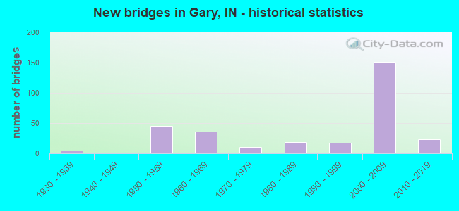
- New bridges - historical statistics
- 11920-1929
- 51930-1939
- 451950-1959
- 361960-1969
- 111970-1979
- 191980-1989
- 181990-1999
- 1512000-2009
- 232010-2019
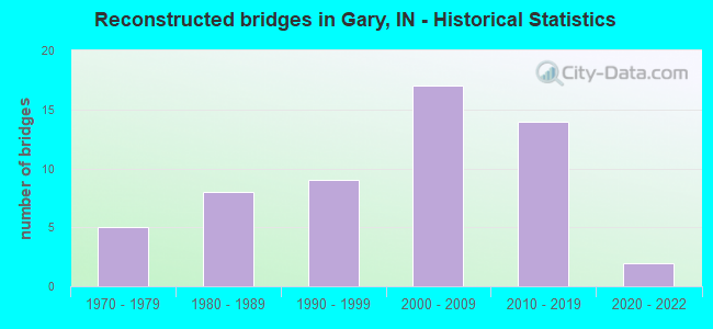
- Reconstructed bridges - Historical Statistics
- 51970-1979
- 81980-1989
- 91990-1999
- 172000-2009
- 142010-2019
- 22020-2022
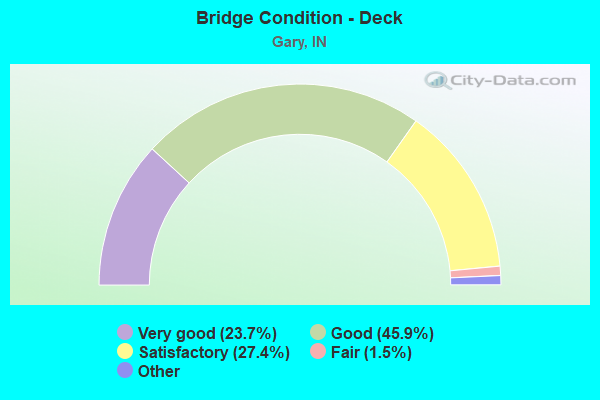
- Bridge Condition - Deck
- 23.7%Very good
- 45.9%Good
- 27.4%Satisfactory
- 1.5%Fair
- 1.5%Poor
- 0.7%Serious
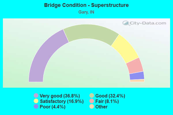
- Bridge Condition - Superstructure
- 36.8%Excellent
- 32.4%Very good
- 16.9%Good
- 8.1%Satisfactory
- 4.4%Fair
- 1.5%Poor
- 0.7%Serious
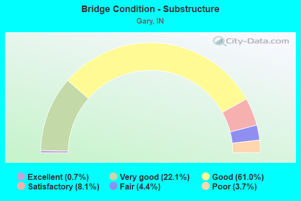
- Bridge Condition - Substructure
- 0.7%Excellent
- 22.1%Very good
- 61.0%Good
- 8.1%Satisfactory
- 4.4%Fair
- 3.7%Poor
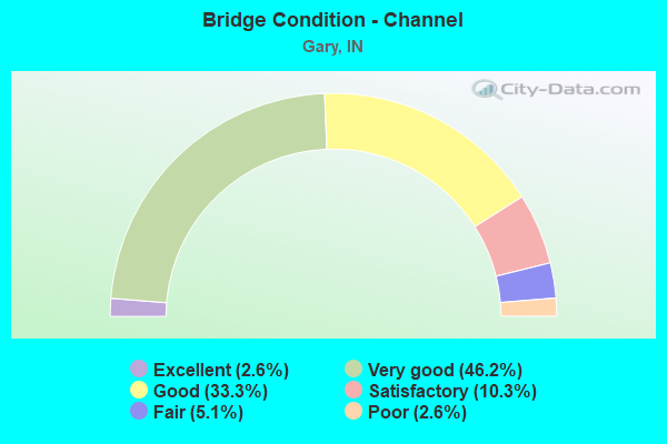
- Bridge Condition - Channel
- 2.6%Excellent
- 46.2%Very good
- 33.3%Good
- 10.3%Satisfactory
- 5.1%Fair
- 2.6%Poor
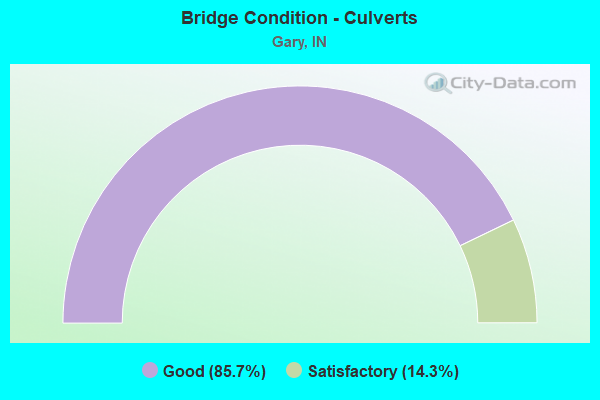
- Bridge Condition - Culverts
- 85.7%Good
- 14.3%Satisfactory
Find on map >> Show street view
Structure Number: 4669, Location: 00.36 E SR 51 (Lat: 41.592689, Lng: -87.232544), Route carried "under" structure: Ramp Interstate 90, Year Built: 1956, Structure Length: 0. m, Average Daily Traffic: 34,670 (year 2014), Truck Traffic: 14%, Features Intersected: I-90 WB
Minimum Vertical Clearance: 9.48m (31.10ft), Kilometerpoint: 33.249, Lanes on structure: 1, Lanes under structure: 5, Toll: On toll road, Material/Design: Steel continuous, Design/Construction: Stringer/Multi-beam, Length of Maximum Span: 19.2m (63.0ft)
Find on map >> Show street view
Structure Number: 4669, Location: 00.36 E SR 51 (Lat: 41.592689, Lng: -87.232544), Route carried "under" structure: Ramp Interstate 90, Year Built: 2015, Structure Length: 0. m, Average Daily Traffic: 5,780 (year 2014), Truck Traffic: 14%, Features Intersected: I-90 RAMP D
Minimum Vertical Clearance: 5.24m (17.19ft), Kilometerpoint: 33.249, Lanes on structure: 1, Lanes under structure: 5, Toll: On toll road, Material/Design: Steel continuous, Design/Construction: Stringer/Multi-beam, Length of Maximum Span: 19.2m (63.0ft)
Find on map >> Show street view
Structure Number: 467, Location: 00.38 E SR 51 (Lat: 41.593031, Lng: -87.233361), Route carried "under" structure: Interstate 90, Year Built: 1956, Structure Length: 0. m, Average Daily Traffic: 34,670 (year 2014), Truck Traffic: 14%, Features Intersected: I-90 EB
Minimum Vertical Clearance: 6.25m (20.51ft), Kilometerpoint: 33.281, Lanes on structure: 1, Lanes under structure: 4, Toll: On toll road, Material/Design: Steel continuous, Design/Construction: Stringer/Multi-beam, Length of Maximum Span: 19.4m (63.6ft)
Find on map >> Show street view
Structure Number: 467, Location: 00.38 E SR 51 (Lat: 41.593031, Lng: -87.233361), Route carried "under" structure: Interstate 90, Year Built: 1956, Structure Length: 0. m, Average Daily Traffic: 34,670 (year 2014), Truck Traffic: 14%, Features Intersected: I-90 WB
Minimum Vertical Clearance: 6.25m (20.51ft), Kilometerpoint: 33.281, Lanes on structure: 1, Lanes under structure: 4, Toll: On toll road, Material/Design: Steel continuous, Design/Construction: Stringer/Multi-beam, Length of Maximum Span: 19.4m (63.6ft)
Find on map >> Show street view
Structure Number: 76504, Location: 01.75 E US-12 (Lat: 41.609131, Lng: -87.360292), Route carried "under" structure: Interstate 90, Year Built: 2008, Structure Length: 0. m, Average Daily Traffic: 40,730 (year 2015), Truck Traffic: 10%, Features Intersected: I-90 EBL (ITR)
Minimum Vertical Clearance: 5.13m (16.83ft), Kilometerpoint: 21.404, Lanes on structure: 2, Lanes under structure: 7, Toll: On toll road, Material/Design: Prestressed concrete continuous, Design/Construction: Tee Beam, Length of Maximum Span: 24.8m (81.4ft)
Find on map >> Show street view
Structure Number: 76504, Location: 01.75 E US-12 (Lat: 41.609131, Lng: -87.360292), Route carried "under" structure: Interstate 90, Year Built: 2008, Structure Length: 0. m, Average Daily Traffic: 40,730 (year 2015), Truck Traffic: 10%, Features Intersected: I-90 WBL (ITR)
Minimum Vertical Clearance: 5.51m (18.08ft), Kilometerpoint: 21.404, Lanes on structure: 2, Lanes under structure: 7, Toll: On toll road, Material/Design: Prestressed concrete continuous, Design/Construction: Tee Beam, Length of Maximum Span: 24.8m (81.4ft)
Find on map >> Show street view
Structure Number: 76506, Location: 00.22 E I-65 (Lat: 41.570019, Lng: -87.296411), Route carried "under" structure: Ramp Interstate 80, Year Built: 2009, Structure Length: 0. m, Average Daily Traffic: 51,070 (year 2010), Truck Traffic: 32%, Features Intersected: RAMPS NED, EB-CD, Facility Carried by Structure: COLORADO STREET
Minimum Vertical Clearance: 5.03m (16.50ft), Kilometerpoint: 19.264, Lanes on structure: 2, Lanes under structure: 13, Material/Design: Steel continuous, Design/Construction: Stringer/Multi-beam, Length of Maximum Span: 48.8m (160.1ft)
Find on map >> Show street view
Structure Number: 76506, Location: 00.22 E I-65 (Lat: 41.570019, Lng: -87.296411), Route carried "under" structure: Ramp Interstate 80, Year Built: 2009, Structure Length: 0. m, Average Daily Traffic: 51,070 (year 2010), Truck Traffic: 32%, Features Intersected: RAMPS WSDIR, WNF, Facility Carried by Structure: COLORADO STREET
Minimum Vertical Clearance: 5.03m (16.50ft), Kilometerpoint: 19.264, Lanes on structure: 2, Lanes under structure: 13, Material/Design: Steel continuous, Design/Construction: Stringer/Multi-beam, Length of Maximum Span: 48.8m (160.1ft)
Find on map >> Show street view
Structure Number: 76506, Location: 00.22 E I-65 (Lat: 41.570019, Lng: -87.296411), Route carried "under" structure: Interstate 80, Year Built: 2009, Structure Length: 0. m, Average Daily Traffic: 51,070 (year 2006), Truck Traffic: 32%, Features Intersected: I-80 MAINLINE WBL, Facility Carried by Structure: COLORADO STREET
Minimum Vertical Clearance: 5.03m (16.50ft), Kilometerpoint: 19.264, Lanes on structure: 2, Lanes under structure: 13, Material/Design: Steel continuous, Design/Construction: Stringer/Multi-beam, Length of Maximum Span: 48.8m (160.1ft)
Find on map >> Show street view
Structure Number: 76516, Location: 00.93 E SR-53 (Lat: 41.567369, Lng: -87.318603), Route carried "under" structure: Interstate 80, Year Built: 2004, Structure Length: 0. m, Average Daily Traffic: 51,933 (year 2004), Truck Traffic: 25%, Features Intersected: I-80 EBL, Facility Carried by Structure: MARTIN LUTHER KING
Minimum Vertical Clearance: 5.03m (16.50ft), Kilometerpoint: 17.413, Lanes on structure: 4, Lanes under structure: 12, Material/Design: Prestressed concrete continuous, Design/Construction: Tee Beam, Length of Maximum Span: 46.9m (153.9ft)
Find on map >> Show street view
Structure Number: 76516, Location: 00.93 E SR-53 (Lat: 41.567369, Lng: -87.318603), Route carried "under" structure: Interstate 80, Year Built: 2004, Structure Length: 0. m, Average Daily Traffic: 51,933 (year 2004), Truck Traffic: 25%, Features Intersected: I-80 WBL, Facility Carried by Structure: MARTIN LUTHER KING
Minimum Vertical Clearance: 5.69m (18.67ft), Kilometerpoint: 17.413, Lanes on structure: 4, Lanes under structure: 12, Material/Design: Prestressed concrete continuous, Design/Construction: Tee Beam, Length of Maximum Span: 46.9m (153.9ft)
Find on map >> Show street view
Structure Number: 76516, Location: 00.93 E SR-53 (Lat: 41.567369, Lng: -87.318603), Route carried "under" structure: Ramp Interstate 80, Year Built: 2004, Structure Length: 0. m, Average Daily Traffic: 30,000 (year 2004), Truck Traffic: 25%, Features Intersected: I-80 WBL Ramp from I-65, Facility Carried by Structure: MARTIN LUTHER KING
Minimum Vertical Clearance: 5.69m (18.67ft), Kilometerpoint: 17.413, Lanes on structure: 4, Lanes under structure: 12, Material/Design: Prestressed concrete continuous, Design/Construction: Tee Beam, Length of Maximum Span: 46.9m (153.9ft)
Find on map >> Show street view
Structure Number: 76518, Location: 01.00 W SR-53 (Lat: 41.569031, Lng: -87.356103), Route carried "under" structure: Interstate 80, Year Built: 2004, Structure Length: 0. m, Average Daily Traffic: 96,221 (year 2004), Truck Traffic: 37%, Features Intersected: I80 (I94) WBL, Facility Carried by Structure: GRANT STREET
Minimum Vertical Clearance: 5.08m (16.67ft), Kilometerpoint: 14.307, Lanes on structure: 6, Lanes under structure: 10, Material/Design: Prestressed concrete continuous, Design/Construction: Tee Beam, Length of Maximum Span: 39.4m (129.3ft)
Find on map >> Show street view
Structure Number: 76518, Location: 01.00 W SR-53 (Lat: 41.569031, Lng: -87.356103), Route carried "under" structure: Ramp Interstate 80, Year Built: 2004, Structure Length: 0. m, Average Daily Traffic: 20,000 (year 2004), Truck Traffic: 37%, Features Intersected: I-80 (I-94) EBL C/D, Facility Carried by Structure: GRANT STREET
Minimum Vertical Clearance: 5.08m (16.67ft), Kilometerpoint: 14.307, Lanes on structure: 6, Lanes under structure: 10, Material/Design: Prestressed concrete continuous, Design/Construction: Tee Beam, Length of Maximum Span: 39.4m (129.3ft)
Find on map >> Show street view
Structure Number: 76518, Location: 01.00 W SR-53 (Lat: 41.569031, Lng: -87.356103), Route carried "under" structure: Ramp Interstate 80, Year Built: 2004, Structure Length: 0. m, Average Daily Traffic: 20,000 (year 2004), Truck Traffic: 37%, Features Intersected: I-80 (I-94) WBL C/D, Facility Carried by Structure: GRANT STREET
Minimum Vertical Clearance: 5.08m (16.67ft), Kilometerpoint: 14.307, Lanes on structure: 6, Lanes under structure: 10, Material/Design: Prestressed concrete continuous, Design/Construction: Tee Beam, Length of Maximum Span: 39.4m (129.3ft)
Find on map >> Show street view
Structure Number: 76518, Location: 01.00 W SR-53 (Lat: 41.569031, Lng: -87.356103), Route carried "under" structure: Interstate 80, Year Built: 2004, Structure Length: 0. m, Average Daily Traffic: 96,221 (year 2004), Truck Traffic: 37%, Features Intersected: I80 (I94) EBL, Facility Carried by Structure: GRANT STREET
Minimum Vertical Clearance: 5.21m (17.09ft), Kilometerpoint: 14.307, Lanes on structure: 6, Lanes under structure: 10, Material/Design: Prestressed concrete continuous, Design/Construction: Tee Beam, Length of Maximum Span: 39.4m (129.3ft)
Find on map >> Show street view
Structure Number: 7652, Location: 02.40 S US-12 (Lat: 41.567500, Lng: -87.336686), Route carried "under" structure: Ramp Interstate 80, Year Built: 2004, Structure Length: 0. m, Average Daily Traffic: 25,000 (year 2006), Truck Traffic: 37%, Features Intersected: I-80 (I-94) EBL C/D, Facility Carried by Structure: SR 53
Minimum Vertical Clearance: 5.54m (18.18ft), Kilometerpoint: 15.916, Lanes on structure: 6, Lanes under structure: 10, Material/Design: Prestressed concrete continuous, Design/Construction: Tee Beam, Length of Maximum Span: 38.5m (126.3ft)
Find on map >> Show street view
Structure Number: 7652, Location: 02.40 S US-12 (Lat: 41.567500, Lng: -87.336686), Route carried "under" structure: Ramp Interstate 80, Year Built: 2004, Structure Length: 0. m, Average Daily Traffic: 25,000 (year 2006), Truck Traffic: 37%, Features Intersected: I-80 (I-94) WBL C/D, Facility Carried by Structure: SR 53
Minimum Vertical Clearance: 5.54m (18.18ft), Kilometerpoint: 15.916, Lanes on structure: 6, Lanes under structure: 10, Material/Design: Prestressed concrete continuous, Design/Construction: Tee Beam, Length of Maximum Span: 38.5m (126.3ft)
Find on map >> Show street view
Structure Number: 7652, Location: 02.40 S US-12 (Lat: 41.567500, Lng: -87.336686), Route carried "under" structure: Interstate 80, Year Built: 2004, Structure Length: 0. m, Average Daily Traffic: 95,330 (year 2006), Truck Traffic: 37%, Features Intersected: I-80 (I-94) WBL, Facility Carried by Structure: SR 53
Minimum Vertical Clearance: 5.54m (18.18ft), Kilometerpoint: 15.916, Lanes on structure: 6, Lanes under structure: 10, Material/Design: Prestressed concrete continuous, Design/Construction: Tee Beam, Length of Maximum Span: 38.5m (126.3ft)
Find on map >> Show street view
Structure Number: 7652, Location: 02.40 S US-12 (Lat: 41.567500, Lng: -87.336686), Route carried "under" structure: Interstate 80, Year Built: 2004, Structure Length: 0. m, Average Daily Traffic: 95,330 (year 2006), Truck Traffic: 37%, Features Intersected: I-80 (I-94) EBL, Facility Carried by Structure: SR 53
Minimum Vertical Clearance: 5.54m (18.18ft), Kilometerpoint: 15.916, Lanes on structure: 6, Lanes under structure: 10, Material/Design: Prestressed concrete continuous, Design/Construction: Tee Beam, Length of Maximum Span: 38.5m (126.3ft)
Find on map >> Show street view
Structure Number: 76746, Location: 06.39 N US-30 (Lat: 41.562231, Lng: -87.307733), Route carried "under" structure: Ramp Interstate 65, Year Built: 2009, Structure Length: 0. m, Average Daily Traffic: 40,000 (year 2008), Truck Traffic: 25%, Features Intersected: RAMP I-80-94 W TO I-65 S
Minimum Vertical Clearance: 5.08m (16.67ft), Kilometerpoint: 18.910, Lanes on structure: 1, Lanes under structure: 2, Material/Design: Steel, Design/Construction: Stringer/Multi-beam, Length of Maximum Span: 45.9m (150.6ft)
Find on map >> Show street view
Structure Number: 7675, Location: 06.45 N US 30 (Lat: 41.562461, Lng: -87.306769), Route carried "under" structure: Ramp Interstate 80, Year Built: 2009, Structure Length: 0. m, Average Daily Traffic: 30,000 (year 2008), Truck Traffic: 24%, Features Intersected: I-65 SBL TO I-80-94 WBL, Facility Carried by Structure: I-65 NB
Minimum Vertical Clearance: 5.33m (17.49ft), Kilometerpoint: 18.910, Lanes on structure: 2, Lanes under structure: 3, Material/Design: Prestressed concrete, Design/Construction: Tee Beam, Length of Maximum Span: 75.7m (248.4ft)
Find on map >> Show street view
Structure Number: 76752, Location: 06.45 N US-30 (Lat: 41.562669, Lng: -87.306847), Route carried "under" structure: Ramp Interstate 80, Year Built: 2009, Structure Length: 0. m, Average Daily Traffic: 30,000 (year 2008), Truck Traffic: 24%, Features Intersected: I-65 NBL TO I-80-94 WBL, Facility Carried by Structure: I-65 SB
Minimum Vertical Clearance: 5.33m (17.49ft), Kilometerpoint: 18.910, Lanes on structure: 3, Lanes under structure: 3, Material/Design: Prestressed concrete, Design/Construction: Tee Beam, Length of Maximum Span: 72.3m (237.2ft)
Find on map >> Show street view
Structure Number: 76754, Location: 01.18 E SR 53 (Lat: 41.567250, Lng: -87.313850), Route carried "under" structure: Ramp Interstate 65, Year Built: 2010, Structure Length: 0. m, Average Daily Traffic: 30,000 (year 2008), Truck Traffic: 30%, Features Intersected: I-65 NB TO I-80 WB, Facility Carried by Structure: I-80/94 EB
Minimum Vertical Clearance: 6.12m (20.08ft), Kilometerpoint: 418.687, Lanes on structure: 4, Lanes under structure: 2, Material/Design: Steel, Design/Construction: Stringer/Multi-beam, Length of Maximum Span: 56.4m (185.0ft)
Find on map >> Show street view
Structure Number: 76756, Location: 01.18 E SR 53 (Lat: 41.567439, Lng: -87.314117), Route carried "under" structure: Ramp Interstate 65, Year Built: 2010, Structure Length: 0. m, Average Daily Traffic: 30,000 (year 2008), Truck Traffic: 30%, Features Intersected: I-65 NB TO I-80 WB, Facility Carried by Structure: I-80/94 WB
Minimum Vertical Clearance: 6.12m (20.08ft), Kilometerpoint: 418.703, Lanes on structure: 4, Lanes under structure: 2, Material/Design: Steel, Design/Construction: Stringer/Multi-beam, Length of Maximum Span: 56.4m (185.0ft)
Find on map >> Show street view
Structure Number: 76766, Location: 00.92 E I-65 (Lat: 41.572250, Lng: -87.283569), Route carried "under" structure: City street , Year Built: 2009, Structure Length: 0. m, Average Daily Traffic: 5,200 (year 2008), Truck Traffic: 12%, Features Intersected: CENTRAL AVENUE, Facility Carried by Structure: I-80 EB
Minimum Vertical Clearance: 7.04m (23.10ft), Kilometerpoint: 0.000, Lanes on structure: 5, Lanes under structure: 4, Material/Design: Steel continuous, Design/Construction: Stringer/Multi-beam, Length of Maximum Span: 46.6m (152.9ft)
Find on map >> Show street view
Structure Number: 76768, Location: 00.92 E I-65 (Lat: 41.572400, Lng: -87.284019), Route carried "under" structure: City street , Year Built: 2010, Structure Length: 0. m, Average Daily Traffic: 5,200 (year 2008), Truck Traffic: 12%, Features Intersected: CENTRAL AVE, Facility Carried by Structure: I-80 WB
Minimum Vertical Clearance: 0.00m, Kilometerpoint: 0.000, Lanes on structure: 6, Lanes under structure: 4, Material/Design: Steel continuous, Design/Construction: Stringer/Multi-beam, Length of Maximum Span: 46.6m (152.9ft)
Find on map >> Show street view
Structure Number: 7677, Location: 01.18 E I-65 (Lat: 41.573169, Lng: -87.278747), Route carried "under" structure: City street , Year Built: 2009, Structure Length: 0. m, Average Daily Traffic: 1,200 (year 2008), Truck Traffic: 10%, Features Intersected: I-80 EB, Facility Carried by Structure: CLAY STREET
Minimum Vertical Clearance: 4.57m (14.99ft), Kilometerpoint: 0.000, Lanes on structure: 4, Lanes under structure: 2, Material/Design: Prestressed concrete, Design/Construction: Stringer/Multi-beam, Length of Maximum Span: 24.4m (80.1ft)
Find on map >> Show street view
Structure Number: 76772, Location: 01.18 E I-65 (Lat: 41.573469, Lng: -87.278778), Route carried "under" structure: City street , Year Built: 2010, Structure Length: 0. m, Average Daily Traffic: 1,200 (year 2008), Truck Traffic: 10%, Features Intersected: I-80 WB, Facility Carried by Structure: CLAY STREET
Minimum Vertical Clearance: 4.57m (14.99ft), Kilometerpoint: 0.000, Lanes on structure: 6, Lanes under structure: 2, Material/Design: Prestressed concrete, Design/Construction: Stringer/Multi-beam, Length of Maximum Span: 24.4m (80.1ft)
Find on map >> Show street view
Structure Number: 76774, Location: 07.00 N US 30 (Lat: 41.569150, Lng: -87.300392), Route carried "under" structure: Interstate 80, Year Built: 2009, Structure Length: 0. m, Average Daily Traffic: 40,000 (year 2008), Truck Traffic: 26%, Features Intersected: I-65 NB RAMP
Minimum Vertical Clearance: 5.16m (16.93ft), Kilometerpoint: 18.926, Lanes on structure: 1, Lanes under structure: 10, Material/Design: Steel continuous, Design/Construction: Girder and Floorbeam System, Length of Maximum Span: 46.6m (152.9ft)
Find on map >> Show street view
Structure Number: 76774, Location: 07.00 N US 30 (Lat: 41.569150, Lng: -87.300392), Route carried "under" structure: Ramp Interstate 80, Year Built: 2009, Structure Length: 0. m, Average Daily Traffic: 10,000 (year 2008), Truck Traffic: 26%, Features Intersected: I-65 NB RAMP
Minimum Vertical Clearance: 5.16m (16.93ft), Kilometerpoint: 18.926, Lanes on structure: 1, Lanes under structure: 10, Material/Design: Steel continuous, Design/Construction: Girder and Floorbeam System, Length of Maximum Span: 46.6m (152.9ft)
Find on map >> Show street view
Structure Number: 76774, Location: 07.00 N US 30 (Lat: 41.569150, Lng: -87.300392), Route carried "under" structure: Interstate 80, Year Built: 2009, Structure Length: 0. m, Average Daily Traffic: 40,000 (year 2008), Truck Traffic: 26%, Features Intersected: I-65 NB RAMP
Minimum Vertical Clearance: 5.16m (16.93ft), Kilometerpoint: 18.926, Lanes on structure: 1, Lanes under structure: 10, Material/Design: Steel continuous, Design/Construction: Girder and Floorbeam System, Length of Maximum Span: 46.6m (152.9ft)
Find on map >> Show street view
Structure Number: 76776, Location: 07.00 N US 30 (Lat: 41.569150, Lng: -87.300736), Route carried "under" structure: Interstate 80, Year Built: 2009, Structure Length: 0. m, Average Daily Traffic: 40,000 (year 2008), Truck Traffic: 28%, Features Intersected: I-65
Minimum Vertical Clearance: 5.26m (17.26ft), Kilometerpoint: 18.910, Lanes on structure: 4, Lanes under structure: 10, Material/Design: Steel continuous, Design/Construction: Stringer/Multi-beam, Length of Maximum Span: 46.6m (152.9ft)
Find on map >> Show street view
Structure Number: 76776, Location: 07.00 N US 30 (Lat: 41.569150, Lng: -87.300736), Route carried "under" structure: Ramp Interstate 80, Year Built: 2009, Structure Length: 0. m, Average Daily Traffic: 12,000 (year 2008), Truck Traffic: 28%, Features Intersected: I-65
Minimum Vertical Clearance: 5.26m (17.26ft), Kilometerpoint: 18.910, Lanes on structure: 4, Lanes under structure: 2, Material/Design: Steel continuous, Design/Construction: Stringer/Multi-beam, Length of Maximum Span: 46.6m (152.9ft)
Find on map >> Show street view
Structure Number: 76776, Location: 07.00 N US 30 (Lat: 41.569150, Lng: -87.300736), Route carried "under" structure: Interstate 80, Year Built: 2009, Structure Length: 0. m, Average Daily Traffic: 40,000 (year 2008), Truck Traffic: 28%, Features Intersected: I-65
Minimum Vertical Clearance: 5.26m (17.26ft), Kilometerpoint: 18.910, Lanes on structure: 4, Lanes under structure: 4, Material/Design: Steel continuous, Design/Construction: Stringer/Multi-beam, Length of Maximum Span: 46.6m (152.9ft)
Find on map >> Show street view
Structure Number: 7678, Location: 07.00 N US 30 (Lat: 41.569111, Lng: -87.301094), Route carried "under" structure: Interstate 80, Year Built: 2009, Structure Length: 0. m, Average Daily Traffic: 40,000 (year 2008), Truck Traffic: 28%, Features Intersected: I-80/94 EBL, Facility Carried by Structure: I-65 SB RAMP
Minimum Vertical Clearance: 5.05m (16.57ft), Kilometerpoint: 18.926, Lanes on structure: 1, Lanes under structure: 10, Material/Design: Steel continuous, Design/Construction: Stringer/Multi-beam, Length of Maximum Span: 46.6m (152.9ft)
Find on map >> Show street view
Structure Number: 7678, Location: 07.00 N US 30 (Lat: 41.569111, Lng: -87.301094), Route carried "under" structure: Interstate 80, Year Built: 2009, Structure Length: 0. m, Average Daily Traffic: 40,000 (year 2008), Truck Traffic: 28%, Features Intersected: I-80/94 WBL, Facility Carried by Structure: I-65 SB RAMP
Minimum Vertical Clearance: 5.05m (16.57ft), Kilometerpoint: 18.926, Lanes on structure: 1, Lanes under structure: 10, Material/Design: Steel continuous, Design/Construction: Stringer/Multi-beam, Length of Maximum Span: 46.6m (152.9ft)
Find on map >> Show street view
Structure Number: 7678, Location: 07.00 N US 30 (Lat: 41.569111, Lng: -87.301094), Route carried "under" structure: Ramp Interstate 80, Year Built: 2009, Structure Length: 0. m, Average Daily Traffic: 12,000 (year 2008), Truck Traffic: 28%, Features Intersected: I-80 EBL COLLECT-DISTRIB, Facility Carried by Structure: I-65 SB RAMP
Minimum Vertical Clearance: 5.05m (16.57ft), Kilometerpoint: 18.926, Lanes on structure: 1, Lanes under structure: 10, Material/Design: Steel continuous, Design/Construction: Stringer/Multi-beam, Length of Maximum Span: 46.6m (152.9ft)
Find on map >> Show street view
Structure Number: 76782, Location: 06.91 N US 30 (Lat: 41.568739, Lng: -87.302764), Route carried "under" structure: Ramp Interstate 80, Year Built: 2009, Structure Length: 0. m, Average Daily Traffic: 12,000 (year 2008), Truck Traffic: 28%, Features Intersected: I-80 EBL RAMP SEC, Facility Carried by Structure: I-65 SB RAMP WSDIR
Minimum Vertical Clearance: 5.89m (19.32ft), Kilometerpoint: 18.733, Lanes on structure: 1, Lanes under structure: 2, Material/Design: Steel continuous, Design/Construction: Stringer/Multi-beam, Length of Maximum Span: 57.6m (189.0ft)
Find on map >> Show street view
Structure Number: 76782, Location: 06.91 N US 30 (Lat: 41.568739, Lng: -87.302764), Route carried "under" structure: Ramp Interstate 80, Year Built: 2009, Structure Length: 0. m, Average Daily Traffic: 3,300 (year 2008), Truck Traffic: 10%, Features Intersected: I-80/94 WB RAMP SW, Facility Carried by Structure: I-65 SB RAMP WSDIR
Minimum Vertical Clearance: 5.05m (16.57ft), Kilometerpoint: 18.733, Lanes on structure: 1, Lanes under structure: 1, Material/Design: Steel continuous, Design/Construction: Stringer/Multi-beam, Length of Maximum Span: 57.6m (189.0ft)
Find on map >> Show street view
Structure Number: 76782, Location: 06.91 N US 30 (Lat: 41.568739, Lng: -87.302764), Route carried "under" structure: Interstate 80, Year Built: 2009, Structure Length: 0. m, Average Daily Traffic: 44,620 (year 2014), Truck Traffic: 28%, Features Intersected: I-80/94 EB, Facility Carried by Structure: I-65 SB RAMP WSDIR
Minimum Vertical Clearance: 7.24m (23.75ft), Kilometerpoint: 18.733, Lanes on structure: 1, Lanes under structure: 3, Material/Design: Steel continuous, Design/Construction: Stringer/Multi-beam, Length of Maximum Span: 57.6m (189.0ft)
Find on map >> Show street view
Structure Number: 76782, Location: 06.91 N US 30 (Lat: 41.568739, Lng: -87.302764), Route carried "under" structure: Interstate 80, Year Built: 2009, Structure Length: 0. m, Average Daily Traffic: 44,620 (year 2014), Truck Traffic: 28%, Features Intersected: I-80/94 WB, Facility Carried by Structure: I-65 SB RAMP WSDIR
Minimum Vertical Clearance: 6.93m (22.74ft), Kilometerpoint: 18.733, Lanes on structure: 1, Lanes under structure: 3, Material/Design: Steel continuous, Design/Construction: Stringer/Multi-beam, Length of Maximum Span: 57.6m (189.0ft)
Find on map >> Show street view
Structure Number: 76782, Location: 06.91 N US 30 (Lat: 41.568739, Lng: -87.302764), Route carried "under" structure: Ramp Interstate 80, Year Built: 2009, Structure Length: 0. m, Average Daily Traffic: 5,000 (year 2000), Truck Traffic: 28%, Features Intersected: I-80/94 EB-CD RAMP, Facility Carried by Structure: I-65 SB RAMP WSDIR
Minimum Vertical Clearance: 7.62m (25.00ft), Kilometerpoint: 18.733, Lanes on structure: 1, Lanes under structure: 2, Material/Design: Steel continuous, Design/Construction: Stringer/Multi-beam, Length of Maximum Span: 57.6m (189.0ft)
Find on map >> Show street view
Structure Number: 76784, Location: 07.10 N US 30 (Lat: 41.570269, Lng: -87.299706), Route carried "under" structure: Ramp Interstate 65, Year Built: 2009, Structure Length: 0. m, Average Daily Traffic: 13,000 (year 2008), Truck Traffic: 9%, Features Intersected: I80 WBL TO I65 SBL RAMP
Minimum Vertical Clearance: 5.08m (16.67ft), Kilometerpoint: 18.910, Lanes on structure: 7, Lanes under structure: 2, Material/Design: Prestressed concrete, Design/Construction: Tee Beam, Length of Maximum Span: 32.9m (107.9ft)
Find on map >> Show street view
Structure Number: 769, Location: 00.50 E SR 53 (Lat: 41.567419, Lng: -87.327081), Route carried "under" structure: Interstate 80, Year Built: 2003, Structure Length: 0. m, Average Daily Traffic: 80,363 (year 2014), Truck Traffic: 35%, Features Intersected: I-80 WB, Facility Carried by Structure: GEORGIA STREET
Minimum Vertical Clearance: 5.03m (16.50ft), Kilometerpoint: 16.721, Lanes on structure: 4, Lanes under structure: 5, Toll: On toll road, Material/Design: Prestressed concrete continuous, Design/Construction: Tee Beam, Length of Maximum Span: 33.8m (110.9ft)
Find on map >> Show street view
Structure Number: 769, Location: 00.50 E SR 53 (Lat: 41.567419, Lng: -87.327081), Route carried "under" structure: Interstate 80, Year Built: 2003, Structure Length: 0. m, Average Daily Traffic: 80,363 (year 2014), Truck Traffic: 35%, Features Intersected: I-80 EB, Facility Carried by Structure: GEORGIA STREET
Minimum Vertical Clearance: 5.03m (16.50ft), Kilometerpoint: 16.721, Lanes on structure: 4, Lanes under structure: 5, Toll: On toll road, Material/Design: Prestressed concrete continuous, Design/Construction: Tee Beam, Length of Maximum Span: 33.8m (110.9ft)
Find on map >> Show street view
Structure Number: 76948, Location: 02.03 W SR 53 (Lat: 41.569719, Lng: -87.375817), Route carried "under" structure: Interstate 80, Year Built: 2003, Structure Length: 0. m, Average Daily Traffic: 88,412 (year 2015), Truck Traffic: 28%, Features Intersected: I-80/94 EB, Facility Carried by Structure: CHASE STREET
Minimum Vertical Clearance: 5.31m (17.42ft), Kilometerpoint: 12.649, Lanes on structure: 4, Lanes under structure: 5, Toll: On toll road, Material/Design: Prestressed concrete continuous, Design/Construction: Tee Beam, Length of Maximum Span: 33.5m (109.9ft)
Find on map >> Show street view
Structure Number: 76948, Location: 02.03 W SR 53 (Lat: 41.569719, Lng: -87.375817), Route carried "under" structure: Interstate 80, Year Built: 2003, Structure Length: 0. m, Average Daily Traffic: 88,412 (year 2015), Truck Traffic: 28%, Features Intersected: I-80/94 WB, Facility Carried by Structure: CHASE STREET
Minimum Vertical Clearance: 5.27m (17.29ft), Kilometerpoint: 12.649, Lanes on structure: 4, Lanes under structure: 5, Toll: On toll road, Material/Design: Prestressed concrete continuous, Design/Construction: Tee Beam, Length of Maximum Span: 33.5m (109.9ft)
Find on map >> Show street view
Structure Number: 4500158, Location: 00.30 N US 12 (Lat: 41.614161, Lng: -87.222550), Route carried "under" structure: ServiceFederal lands road , Year Built: 1992, Structure Length: 0. m, Average Daily Traffic: 2,251 (year 2012), Truck Traffic: 5%, Features Intersected: NATIONAL PARK ROAD, Facility Carried by Structure: COUNTY LINE RD
Minimum Vertical Clearance: 4.75m (15.58ft), Kilometerpoint: 0.000, Lanes on structure: 3, Lanes under structure: 2, Material/Design: Concrete, Design/Construction: Slab, Length of Maximum Span: 27.4m (89.9ft)
Find on map >> Show street view
Structure Number: 4500209, Location: 00.70 E. of SR 912 (Lat: 41.639169, Lng: -87.418556), Route carried "under" structure: ServiceOther road , Year Built: 2007, Structure Length: 0. m, Average Daily Traffic: 20 (year 2010), Truck Traffic: 2%, Features Intersected: ACCESS ROAD, Facility Carried by Structure: BUFFINGTON HRBR DR
Minimum Vertical Clearance: 5.87m (19.26ft), Kilometerpoint: 0.000, Lanes on structure: 2, Lanes under structure: 2, Material/Design: Steel continuous, Design/Construction: Stringer/Multi-beam, Length of Maximum Span: 42.7m (140.1ft)
Find on map >> Show street view
Structure Number: 450021, Location: 00.70 E. of SR 912 (Lat: 41.639419, Lng: -87.418944), Route carried "under" structure: Alternate City street , Year Built: 2005, Structure Length: 0. m, Average Daily Traffic: 200 (year 2010), Truck Traffic: 2%, Features Intersected: ACCESS ROAD, Facility Carried by Structure: ACCESS ROAD RAMP
Minimum Vertical Clearance: 7.44m (24.41ft), Kilometerpoint: 0.000, Lanes on structure: 3, Lanes under structure: 2, Material/Design: Prestressed concrete continuous, Design/Construction: Tee Beam, Length of Maximum Span: 29.6m (97.1ft)