Bridge Statistics for Gates, New York (NY)
Condition, Traffic, Stress, Structural Evaluation, Project Costs
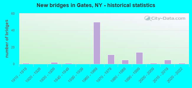
- New bridges - historical statistics
- 11910-1919
- 21930-1939
- 11940-1949
- 501960-1969
- 111970-1979
- 51980-1989
- 141990-1999
- 12000-2009
- 52010-2019
- 12020-2022
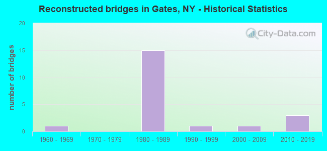
- Reconstructed bridges - Historical Statistics
- 11960-1969
- 01970-1979
- 151980-1989
- 11990-1999
- 12000-2009
- 32010-2019
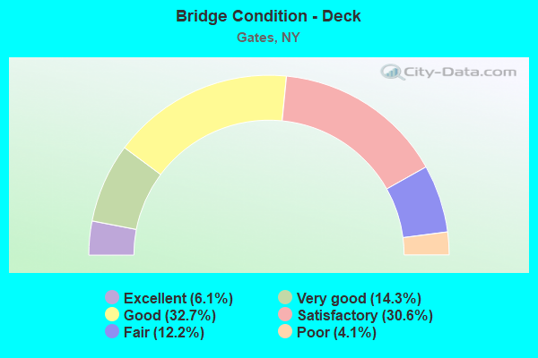
- Bridge Condition - Deck
- 6.1%Excellent
- 14.3%Very good
- 32.7%Good
- 30.6%Satisfactory
- 12.2%Fair
- 4.1%Poor
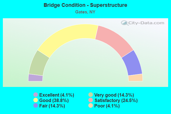
- Bridge Condition - Superstructure
- 4.1%Excellent
- 14.3%Very good
- 38.8%Good
- 24.5%Satisfactory
- 14.3%Fair
- 4.1%Poor
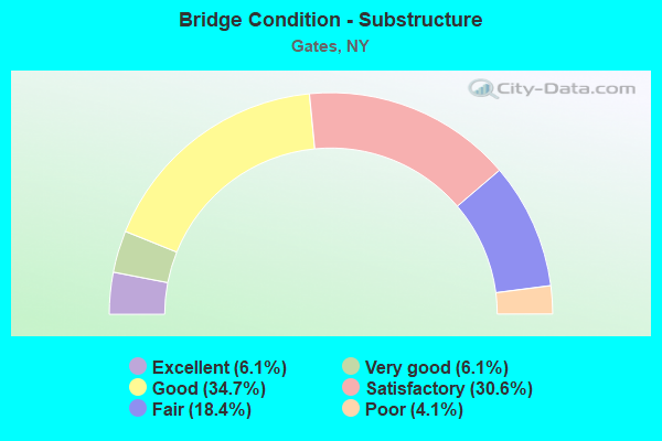
- Bridge Condition - Substructure
- 6.1%Excellent
- 6.1%Very good
- 34.7%Good
- 30.6%Satisfactory
- 18.4%Fair
- 4.1%Poor
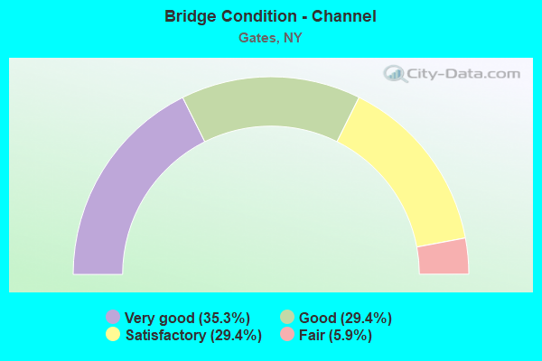
- Bridge Condition - Channel
- 35.3%Very good
- 29.4%Good
- 29.4%Satisfactory
- 5.9%Fair
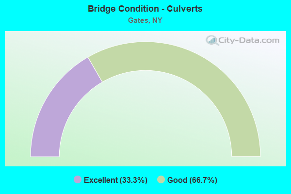
- Bridge Condition - Culverts
- 33.3%Excellent
- 66.7%Good
Find on map >> Show street view
Structure Number: 1021589, Location: JCT RTS31+47 LYELL AVE (Lat: 43.164697, Lng: -77.683044), Route carried "on" structure: State highway 31, Year Built: 2018, Status: Open, Structure Length: 6.89m (22.60ft), Average Daily Traffic: 23,224 (year 2019), Truck Traffic: 4%, Average Future Daily Traffic: 28,212 (year 2040), Design Load: HL 93, Features Intersected: 390 390 43011005, RTE 39
Minimum Vertical Clearance: 30+ m (98+ ft), Kilometerpoint: 28.946, Lanes on structure: 6, Lanes under structure: 9, Base Highway Network: Yes, Owner: State Highway Agency, Approaching Roadway Width: 27.7m (90.9ft), Skew: 20 degrees, Material/Design: Steel, Design/Construction: Stringer/Multi-beam, Number Of Spans In Main Unit: 2, Length of Maximum Span: 33.5m (109.9ft), Curb or Sidewalk Widths: Left: 1.5m (4.9ft), Right: 1.5m (4.9ft), Curb-To-Curb Width: 27.7m (90.9ft), Out-to-Out Width: 32.1m (105.3ft)
Condition: Deck: Very good, Superstructure: Excellent, Substructure: Excellent, Inventory Rating: 62.6 metric tons, Method Used To Determine Inventory Rating: Load Factor (LF), Structural Evaluation: Superior to present desirable criteria, Deck Geometry: Equal to present desirable criteria, Underclear: High priority of corrective action, Approach Roadway Alignment: Equal to present desirable criteria, Length Of Structure Improvement: 6.88m (22.57ft), Designated Inspection Frequency: Every 24 months, Inspection Date: October 2020, Bridge Improvement Cost: $5,898,000, Roadway Improvement Cost: $3,454,000, Total Project Cost: $9,352,000 ( Estimate for 2021), Deck Structure Type: Concrete Cast-file-Place, Wearing Surface/Protective System: Wearing Surface: Integral Concrete
Find on map >> Show street view
Structure Number: 1023021, Location: JCT RTS I490SB+33 GATES (Lat: 43.145269, Lng: -77.717972), Route carried "on" structure: Interstate 490, Year Built: 1963, Year Reconstructed: 1991, Status: Open, Structure Length: 5.70m (18.70ft), Average Daily Traffic: 25,670 (year 2015), Truck Traffic: 9%, Design Load: HS 20+Mod, Features Intersected: 33 33 43031117 WB, RTE
Minimum Vertical Clearance: 30+ m (98+ ft), Kilometerpoint: 24.457, Lanes on structure: 4, Lanes under structure: 6, Base Highway Network: Yes, Owner: State Highway Agency, Approaching Roadway Width: 18.3m (60.0ft), Skew: 2 degrees, Material/Design: Steel, Design/Construction: Stringer/Multi-beam, Number Of Spans In Main Unit: 4, Length of Maximum Span: 18.2m (59.7ft), Curb-To-Curb Width: 18.0m (59.1ft), Out-to-Out Width: 18.9m (62.0ft)
Condition: Deck: Very good, Superstructure: Good, Substructure: Satisfactory, Operating Rating: 67.1 metric tons, Method Used To Determine Operating Rating: Load Factor (LF), Inventory Rating: 40.8 metric tons, Method Used To Determine Inventory Rating: Load Factor (LF), Structural Evaluation: Equal to present minimum criteria, Deck Geometry: Meets minimum limits, Underclear: Meets minimum limits, Approach Roadway Alignment: Equal to present minimum criteria, Length Of Structure Improvement: 5.69m (18.67ft), Designated Inspection Frequency: Every 24 months, Inspection Date: March 2021, Bridge Improvement Cost: $2,509,000, Roadway Improvement Cost: $1,469,000, Total Project Cost: $3,978,000 ( Estimate for 2021), Deck Structure Type: Concrete Cast-file-Place, Wearing Surface/Protective System: Wearing Surface: Integral Concrete, Deck Protection: Epoxy Coated Reinforcing
Find on map >> Show street view
Structure Number: 1023022, Location: JCT RTS I490NB+33 GATES (Lat: 43.145478, Lng: -77.717283), Route carried "on" structure: Interstate 490, Year Built: 1963, Year Reconstructed: 1991, Status: Open, Structure Length: 5.61m (18.41ft), Average Daily Traffic: 17,655 (year 2020), Truck Traffic: 9%, Average Future Daily Traffic: 24,553 (year 2040), Design Load: HS 20+Mod, Features Intersected: 33 33 43031117 WB, RTE
Minimum Vertical Clearance: 30+ m (98+ ft), Kilometerpoint: 24.457, Lanes on structure: 4, Lanes under structure: 6, Base Highway Network: Yes, Owner: State Highway Agency, Approaching Roadway Width: 18.3m (60.0ft), Skew: 2 degrees, Material/Design: Steel, Design/Construction: Stringer/Multi-beam, Number Of Spans In Main Unit: 4, Length of Maximum Span: 18.2m (59.7ft), Curb-To-Curb Width: 18.0m (59.1ft), Out-to-Out Width: 18.9m (62.0ft)
Condition: Deck: Satisfactory, Superstructure: Good, Substructure: Satisfactory, Operating Rating: 67.1 metric tons, Method Used To Determine Operating Rating: Load Factor (LF), Inventory Rating: 40.8 metric tons, Method Used To Determine Inventory Rating: Load Factor (LF), Structural Evaluation: Equal to present minimum criteria, Deck Geometry: Meets minimum limits, Underclear: Meets minimum limits, Approach Roadway Alignment: Equal to present minimum criteria, Length Of Structure Improvement: 5.60m (18.37ft), Designated Inspection Frequency: Every 24 months, Inspection Date: March 2021, Bridge Improvement Cost: $2,473,000, Roadway Improvement Cost: $1,448,000, Total Project Cost: $3,921,000 ( Estimate for 2021), Deck Structure Type: Concrete Cast-file-Place, Wearing Surface/Protective System: Wearing Surface: Integral Concrete, Deck Protection: Epoxy Coated Reinforcing
Find on map >> Show street view
Structure Number: 102303, Location: 3.0MI E JCT RTS 33+251 (Lat: 43.149967, Lng: -77.678633), Route carried "on" structure: State highway 33, Year Built: 2021, Status: Open, Structure Length: 5.76m (18.90ft), Average Daily Traffic: 8,973 (year 2019), Truck Traffic: 6%, Average Future Daily Traffic: 10,900 (year 2040), Design Load: HL 93, Features Intersected: 390I390I43037016 NB, 390
Minimum Vertical Clearance: 32.69m (107.25ft), Kilometerpoint: 22.108, Lanes on structure: 2, Lanes under structure: 7, Owner: State Highway Agency, Approaching Roadway Width: 12.2m (40.0ft), Skew: 2 degrees, Material/Design: Steel, Design/Construction: Stringer/Multi-beam, Number Of Spans In Main Unit: 2, Length of Maximum Span: 30.8m (101.0ft), Curb-To-Curb Width: 12.2m (40.0ft), Out-to-Out Width: 13.5m (44.3ft)
Condition: Deck: Excellent, Superstructure: Excellent, Substructure: Excellent, Inventory Rating: 60.8 metric tons, Method Used To Determine Inventory Rating: Load Factor (LF), Structural Evaluation: Superior to present desirable criteria, Deck Geometry: Somewhat better than minimum adequacy, Underclear: Somewhat better than minimum adequacy, Approach Roadway Alignment: Equal to present desirable criteria, Designated Inspection Frequency: Every 24 months, Inspection Date: November 2021, Deck Structure Type: Concrete Cast-file-Place, Wearing Surface/Protective System: Wearing Surface: Integral Concrete, Deck Protection: Epoxy Coated Reinforcing
Find on map >> Show street view
Structure Number: 1023099, Location: 1.3 MI SW JCT I390 & 33A (Lat: 43.130408, Lng: -77.692217), Route carried "on" structure: Alternate State highway 33A, Year Built: 2001, Status: Open, Structure Length: 0.94m (3.08ft), Average Daily Traffic: 15,290 (year 2018), Truck Traffic: 5%, Average Future Daily Traffic: 15,361 (year 2040), Design Load: HS 25 or greater, Features Intersected: LITTLE BLACK CRK
Minimum Vertical Clearance: 30+ m (98+ ft), Kilometerpoint: 22.092, Lanes on structure: 4, Base Highway Network: Yes, Owner: State Highway Agency, Approaching Roadway Width: 21.0m (68.9ft), Skew: 21 degrees, Material/Design: Concrete, Design/Construction: Culvert, Number Of Spans In Main Unit: 1, Length of Maximum Span: 9.1m (29.9ft), Curb or Sidewalk Widths: Left: 1.5m (4.9ft), Right: 1.5m (4.9ft), Curb-To-Curb Width: 21.0m (68.9ft), Out-to-Out Width: 24.9m (81.7ft)
Condition: Channel: Good, Culverts: Excellent, Operating Rating: 79.1 metric tons, Method Used To Determine Operating Rating: Field evaluation and documented engineering judgment, Inventory Rating: 40.8 metric tons, Method Used To Determine Inventory Rating: Field evaluation and documented engineering judgment, Structural Evaluation: Superior to present desirable criteria, Deck Geometry: Superior to present desirable criteria, Waterway Adequacy: Equal to present minimum criteria, Approach Roadway Alignment: Equal to present desirable criteria, Length Of Structure Improvement: 0.94m (3.08ft), Designated Inspection Frequency: Every 24 months, Inspection Date: July 2021, Bridge Improvement Cost: $1,155,000, Roadway Improvement Cost: $676,000, Total Project Cost: $1,831,000 ( Estimate for 2021)
Find on map >> Show street view
Structure Number: 1023101, Location: JCT.ROCH.OUT.LOOP NB& 33A (Lat: 43.139511, Lng: -77.668025), Route carried "on" structure: Interstate 390, Year Built: 1979, Status: Open, Structure Length: 4.51m (14.80ft), Average Daily Traffic: 36,993 (year 2020), Truck Traffic: 7%, Average Future Daily Traffic: 51,445 (year 2040), Design Load: HS 20, Features Intersected: RTE 33A
Minimum Vertical Clearance: 30+ m (98+ ft), Kilometerpoint: 28.495, Lanes on structure: 4, Lanes under structure: 4, Base Highway Network: Yes, Owner: State Highway Agency, Approaching Roadway Width: 18.3m (60.0ft), Skew: 1 degrees, Material/Design: Steel, Design/Construction: Stringer/Multi-beam, Number Of Spans In Main Unit: 1, Length of Maximum Span: 43.6m (143.0ft), Curb-To-Curb Width: 18.1m (59.4ft), Out-to-Out Width: 19.1m (62.7ft)
Condition: Deck: Satisfactory, Superstructure: Good, Substructure: Good, Operating Rating: 89.8 metric tons, Method Used To Determine Operating Rating: Load Factor (LF), Inventory Rating: 51.7 metric tons, Method Used To Determine Inventory Rating: Load Factor (LF), Structural Evaluation: Better than present minimum criteria, Deck Geometry: Meets minimum limits, Underclear: High priority of corrective action, Approach Roadway Alignment: Equal to present desirable criteria, Length Of Structure Improvement: 4.51m (14.80ft), Designated Inspection Frequency: Every 24 months, Inspection Date: June 2021, Bridge Improvement Cost: $2,250,000, Roadway Improvement Cost: $1,318,000, Total Project Cost: $3,567,000 ( Estimate for 2021), Deck Structure Type: Concrete Cast-file-Place, Wearing Surface/Protective System: Wearing Surface: Integral Concrete, Deck Protection: Epoxy Coated Reinforcing
Find on map >> Show street view
Structure Number: 1023102, Location: JCT.ROCH.OUT.LOOP SB& 33A (Lat: 43.139411, Lng: -77.668319), Route carried "on" structure: Interstate 390, Year Built: 1979, Status: Open, Structure Length: 4.51m (14.80ft), Average Daily Traffic: 43,379 (year 2012), Truck Traffic: 6%, Design Load: HS 20, Features Intersected: RTE 33A
Minimum Vertical Clearance: 30+ m (98+ ft), Kilometerpoint: 1.126, Lanes on structure: 4, Lanes under structure: 4, Base Highway Network: Yes, Owner: State Highway Agency, Approaching Roadway Width: 18.3m (60.0ft), Skew: 1 degrees, Material/Design: Steel, Design/Construction: Stringer/Multi-beam, Number Of Spans In Main Unit: 1, Length of Maximum Span: 43.5m (142.7ft), Curb-To-Curb Width: 18.1m (59.4ft), Out-to-Out Width: 19.1m (62.7ft)
Condition: Deck: Satisfactory, Superstructure: Good, Substructure: Good, Operating Rating: 89.8 metric tons, Method Used To Determine Operating Rating: Load Factor (LF), Inventory Rating: 51.7 metric tons, Method Used To Determine Inventory Rating: Load Factor (LF), Structural Evaluation: Better than present minimum criteria, Deck Geometry: Meets minimum limits, Underclear: High priority of corrective action, Approach Roadway Alignment: Equal to present desirable criteria, Length Of Structure Improvement: 4.51m (14.80ft), Designated Inspection Frequency: Every 24 months, Inspection Date: June 2021, Bridge Improvement Cost: $2,225,000, Roadway Improvement Cost: $1,303,000, Total Project Cost: $3,528,000 ( Estimate for 2021), Deck Structure Type: Concrete Cast-file-Place, Wearing Surface/Protective System: Wearing Surface: Integral Concrete, Deck Protection: Epoxy Coated Reinforcing
Find on map >> Show street view
Structure Number: 1025811, Location: JCT RTSI490WB+47SB GATES (Lat: 43.158367, Lng: -77.682183), Route carried "on" structure: Interstate 490, Year Built: 1961, Year Reconstructed: 1993, Status: Open, Structure Length: 4.21m (13.81ft), Average Daily Traffic: 6,078 (year 2018), Truck Traffic: 5%, Average Future Daily Traffic: 8,716 (year 2039), Design Load: HS 20+Mod, Features Intersected: RTE 390, I490EB TO 390 N
Minimum Vertical Clearance: 4.47m (14.67ft), Kilometerpoint: 0.386, Lanes on structure: 3, Lanes under structure: 4, Owner: State Highway Agency, Approaching Roadway Width: 14.0m (45.9ft), Material/Design: Steel, Design/Construction: Stringer/Multi-beam, Number Of Spans In Main Unit: 3, Length of Maximum Span: 17.6m (57.7ft), Curb-To-Curb Width: 14.1m (46.3ft), Out-to-Out Width: 15.0m (49.2ft)
Condition: Deck: Very good, Superstructure: Satisfactory, Substructure: Good, Operating Rating: 54.8 metric tons, Method Used To Determine Operating Rating: Load and Resistance Factor Rating (LRFR) rating reported by rating factor(RF) method using HL-93 loadings, Inventory Rating: 42.1 metric tons, Method Used To Determine Inventory Rating: Load and Resistance Factor Rating (LRFR) rating reported by rating factor(RF) method using HL-93 loadings, Structural Evaluation: Equal to present minimum criteria, Deck Geometry: High priority of corrective action, Underclear: High priority of corrective action, Approach Roadway Alignment: Equal to present minimum criteria, Length Of Structure Improvement: 4.20m (13.78ft), Designated Inspection Frequency: Every 24 months, Inspection Date: November 2021, Bridge Improvement Cost: $1,552,000, Roadway Improvement Cost: $909,000, Total Project Cost: $2,461,000 ( Estimate for 2021), Deck Structure Type: Concrete Cast-file-Place, Wearing Surface/Protective System: Wearing Surface: Bituminous, Deck Protection: Epoxy Coated Reinforcing
Find on map >> Show street view
Structure Number: 1025812, Location: JCT RTSI490EB+47SB GATES (Lat: 43.156306, Lng: -77.681778), Route carried "on" structure: Interstate 490, Year Built: 1963, Year Reconstructed: 1993, Status: Open, Structure Length: 4.05m (13.29ft), Average Daily Traffic: 37,687 (year 2020), Truck Traffic: 7%, Average Future Daily Traffic: 52,410 (year 2040), Design Load: HS 20+Mod, Features Intersected: RTE I390
Minimum Vertical Clearance: 32.69m (107.25ft), Kilometerpoint: 28.415, Lanes on structure: 2, Lanes under structure: 2, Base Highway Network: Yes, Owner: State Highway Agency, Approaching Roadway Width: 11.6m (38.1ft), Skew: 1 degrees, Material/Design: Steel, Design/Construction: Stringer/Multi-beam, Number Of Spans In Main Unit: 3, Length of Maximum Span: 13.7m (44.9ft), Curb or Sidewalk Widths: Left: 0.3m (1.0ft), Right: 0.3m (1.0ft), Curb-To-Curb Width: 9.5m (31.2ft), Out-to-Out Width: 10.4m (34.1ft)
Condition: Deck: Good, Superstructure: Satisfactory, Substructure: Good, Operating Rating: 45.7 metric tons, Method Used To Determine Operating Rating: Load and Resistance Factor Rating (LRFR) rating reported by rating factor(RF) method using HL-93 loadings, Inventory Rating: 35.0 metric tons, Method Used To Determine Inventory Rating: Load and Resistance Factor Rating (LRFR) rating reported by rating factor(RF) method using HL-93 loadings, Structural Evaluation: Equal to present minimum criteria, Deck Geometry: High priority of replacement, Underclear: High priority of corrective action, Approach Roadway Alignment: Equal to present minimum criteria, Length Of Structure Improvement: 4.05m (13.29ft), Designated Inspection Frequency: Every 24 months, Inspection Date: August 2021, Bridge Improvement Cost: $1,025,000, Roadway Improvement Cost: $600,000, Total Project Cost: $1,624,000 ( Estimate for 2021), Deck Structure Type: Concrete Cast-file-Place, Wearing Surface/Protective System: Wearing Surface: Bituminous, Deck Protection: Epoxy Coated Reinforcing
Find on map >> Show street view
Structure Number: 102582, Location: JCT RTSI490WB+47NB GATES (Lat: 43.156403, Lng: -77.679094), Route carried "on" structure: Interstate 490, Year Built: 1963, Year Reconstructed: 1991, Status: Open, Structure Length: 6.49m (21.29ft), Average Daily Traffic: 75,373 (year 2020), Truck Traffic: 7%, Average Future Daily Traffic: 104,821 (year 2040), Design Load: HS 20, Features Intersected: RTE I390, RTE I490
Minimum Vertical Clearance: 4.69m (15.39ft), Kilometerpoint: 28.624, Lanes on structure: 4, Lanes under structure: 5, Base Highway Network: Yes, Owner: State Highway Agency, Approaching Roadway Width: 17.1m (56.1ft), Skew: 5 degrees, Material/Design: Steel, Design/Construction: Stringer/Multi-beam, Number Of Spans In Main Unit: 3, Length of Maximum Span: 22.2m (72.8ft), Curb-To-Curb Width: 17.6m (57.7ft), Out-to-Out Width: 18.5m (60.7ft)
Condition: Deck: Good, Superstructure: Fair, Substructure: Good, Operating Rating: 69.9 metric tons, Method Used To Determine Operating Rating: Load Factor (LF), Inventory Rating: 36.3 metric tons, Method Used To Determine Inventory Rating: Load Factor (LF), Structural Evaluation: Somewhat better than minimum adequacy, Deck Geometry: High priority of corrective action, Underclear: High priority of corrective action, Approach Roadway Alignment: Equal to present minimum criteria, Length Of Structure Improvement: 6.49m (21.29ft), Designated Inspection Frequency: Every 24 months, Inspection Date: September 2020, Bridge Improvement Cost: $3,103,000, Roadway Improvement Cost: $1,817,000, Total Project Cost: $4,920,000 ( Estimate for 2021), Deck Structure Type: Concrete Cast-file-Place, Wearing Surface/Protective System: Wearing Surface: Bituminous, Deck Protection: Epoxy Coated Reinforcing
Find on map >> Show street view
Structure Number: 1025841, Location: .2 M SW JCT SH33A & I390 (Lat: 43.138300, Lng: -77.666675), Route carried "on" structure: Interstate 390, Year Built: 1998, Status: Open, Structure Length: 6.31m (20.70ft), Average Daily Traffic: 32,315 (year 2020), Truck Traffic: 7%, Average Future Daily Traffic: 44,940 (year 2040), Design Load: HS 25 or greater, Features Intersected: ROCH & SOUTHERN R
Minimum Vertical Clearance: 30+ m (98+ ft), Kilometerpoint: 28.302, Lanes on structure: 4, Base Highway Network: Yes, Owner: State Highway Agency, Approaching Roadway Width: 18.3m (60.0ft), Skew: 1 degrees, Material/Design: Steel continuous, Design/Construction: Stringer/Multi-beam, Number Of Spans In Main Unit: 4, Length of Maximum Span: 17.0m (55.8ft), Curb-To-Curb Width: 15.7m (51.5ft), Out-to-Out Width: 16.6m (54.5ft)
Condition: Deck: Good, Superstructure: Good, Substructure: Good, Operating Rating: 74.4 metric tons, Method Used To Determine Operating Rating: Load Factor (LF), Inventory Rating: 44.5 metric tons, Method Used To Determine Inventory Rating: Load Factor (LF), Structural Evaluation: Better than present minimum criteria, Deck Geometry: Meets minimum limits, Underclear: Meets minimum limits, Approach Roadway Alignment: Equal to present desirable criteria, Length Of Structure Improvement: 6.30m (20.67ft), Designated Inspection Frequency: Every 24 months, Inspection Date: December 2020, Bridge Improvement Cost: $2,440,000, Roadway Improvement Cost: $1,429,000, Total Project Cost: $3,869,000 ( Estimate for 2021), Deck Structure Type: Concrete Cast-file-Place, Wearing Surface/Protective System: Wearing Surface: Integral Concrete, Deck Protection: Epoxy Coated Reinforcing
Find on map >> Show street view
Structure Number: 1025842, Location: .2 MI SE JCT SH33A & I390 (Lat: 43.138178, Lng: -77.666947), Route carried "on" structure: Interstate 390, Year Built: 1996, Status: Open, Structure Length: 6.46m (21.19ft), Average Daily Traffic: 41,407 (year 2012), Truck Traffic: 6%, Design Load: HS 25 or greater, Features Intersected: ROCH & SOUTHERN
Minimum Vertical Clearance: 30+ m (98+ ft), Kilometerpoint: 28.383, Lanes on structure: 4, Base Highway Network: Yes, Owner: State Highway Agency, Approaching Roadway Width: 18.3m (60.0ft), Skew: 1 degrees, Material/Design: Steel continuous, Design/Construction: Stringer/Multi-beam, Number Of Spans In Main Unit: 4, Length of Maximum Span: 18.8m (61.7ft), Curb-To-Curb Width: 18.1m (59.4ft), Out-to-Out Width: 19.1m (62.7ft)
Condition: Deck: Good, Superstructure: Good, Substructure: Good, Operating Rating: 70.8 metric tons, Method Used To Determine Operating Rating: Load Factor (LF), Inventory Rating: 42.6 metric tons, Method Used To Determine Inventory Rating: Load Factor (LF), Structural Evaluation: Better than present minimum criteria, Deck Geometry: Meets minimum limits, Underclear: High priority of corrective action, Approach Roadway Alignment: Equal to present desirable criteria, Length Of Structure Improvement: 6.46m (21.19ft), Designated Inspection Frequency: Every 24 months, Inspection Date: December 2020, Bridge Improvement Cost: $2,858,000, Roadway Improvement Cost: $1,674,000, Total Project Cost: $4,531,000 ( Estimate for 2021), Deck Structure Type: Concrete Cast-file-Place, Wearing Surface/Protective System: Wearing Surface: Integral Concrete, Deck Protection: Epoxy Coated Reinforcing
Find on map >> Show street view
Structure Number: 1025851, Location: .2 M SW JCT RT 33A&390I N (Lat: 43.137650, Lng: -77.665964), Route carried "on" structure: Interstate 390, Year Built: 1997, Status: Open, Structure Length: 6.95m (22.80ft), Average Daily Traffic: 32,315 (year 2020), Truck Traffic: 7%, Average Future Daily Traffic: 44,940 (year 2040), Design Load: HS 25 or greater, Features Intersected: BUELL ROAD
Minimum Vertical Clearance: 30+ m (98+ ft), Kilometerpoint: 28.206, Lanes on structure: 4, Lanes under structure: 2, Base Highway Network: Yes, Owner: State Highway Agency, Approaching Roadway Width: 15.8m (51.8ft), Skew: 5 degrees, Material/Design: Steel continuous, Design/Construction: Stringer/Multi-beam, Number Of Spans In Main Unit: 3, Length of Maximum Span: 28.3m (92.8ft), Curb-To-Curb Width: 18.3m (60.0ft), Out-to-Out Width: 19.1m (62.7ft)
Condition: Deck: Good, Superstructure: Good, Substructure: Good, Operating Rating: 78.9 metric tons, Method Used To Determine Operating Rating: Load Factor (LF), Inventory Rating: 47.2 metric tons, Method Used To Determine Inventory Rating: Load Factor (LF), Structural Evaluation: Better than present minimum criteria, Deck Geometry: Meets minimum limits, Underclear: Meets minimum limits, Approach Roadway Alignment: Equal to present desirable criteria, Length Of Structure Improvement: 6.94m (22.77ft), Designated Inspection Frequency: Every 24 months, Inspection Date: July 2021, Bridge Improvement Cost: $3,909,000, Roadway Improvement Cost: $2,289,000, Total Project Cost: $6,198,000 ( Estimate for 2021), Deck Structure Type: Concrete Cast-file-Place, Wearing Surface/Protective System: Wearing Surface: Integral Concrete, Deck Protection: Epoxy Coated Reinforcing
Find on map >> Show street view
Structure Number: 1025852, Location: .2 M SW JCT 33A & 390I SB (Lat: 43.137256, Lng: -77.665947), Route carried "on" structure: Interstate 390, Year Built: 1997, Status: Open, Structure Length: 7.28m (23.88ft), Average Daily Traffic: 41,407 (year 2012), Truck Traffic: 6%, Design Load: HS 25 or greater, Features Intersected: Buell Road
Minimum Vertical Clearance: 30+ m (98+ ft), Kilometerpoint: 28.270, Lanes on structure: 4, Lanes under structure: 2, Base Highway Network: Yes, Owner: State Highway Agency, Approaching Roadway Width: 18.3m (60.0ft), Skew: 5 degrees, Material/Design: Steel continuous, Design/Construction: Stringer/Multi-beam, Number Of Spans In Main Unit: 3, Length of Maximum Span: 29.8m (97.8ft), Curb-To-Curb Width: 18.3m (60.0ft), Out-to-Out Width: 19.1m (62.7ft)
Condition: Deck: Good, Superstructure: Good, Substructure: Good, Operating Rating: 46.3 metric tons, Method Used To Determine Operating Rating: Load and Resistance Factor Rating (LRFR) rating reported by rating factor(RF) method using HL-93 loadings, Inventory Rating: 35.6 metric tons, Method Used To Determine Inventory Rating: Load and Resistance Factor Rating (LRFR) rating reported by rating factor(RF) method using HL-93 loadings, Structural Evaluation: Better than present minimum criteria, Deck Geometry: Meets minimum limits, Underclear: Meets minimum limits, Approach Roadway Alignment: Equal to present desirable criteria, Length Of Structure Improvement: 7.28m (23.88ft), Designated Inspection Frequency: Every 24 months, Inspection Date: July 2021, Bridge Improvement Cost: $3,844,000, Roadway Improvement Cost: $2,251,000, Total Project Cost: $6,095,000 ( Estimate for 2021), Deck Structure Type: Concrete Cast-file-Place, Wearing Surface/Protective System: Wearing Surface: Integral Concrete, Deck Protection: Epoxy Coated Reinforcing
Find on map >> Show street view
Structure Number: 1025869, Location: 0.6MI SE JCT RTS47+33A (Lat: 43.130850, Lng: -77.661194), Route carried "on" structure: State highway 204, Year Built: 1963, Status: Open, Structure Length: 9.11m (29.89ft), Average Daily Traffic: 21,315 (year 2019), Truck Traffic: 4%, Average Future Daily Traffic: 21,415 (year 2040), Design Load: HS 20, Features Intersected: 390I390I43037000 NB, RTE
Minimum Vertical Clearance: 30+ m (98+ ft), Kilometerpoint: 5.084, Lanes on structure: 6, Lanes under structure: 8, Base Highway Network: Yes, Owner: State Highway Agency, Approaching Roadway Width: 25.0m (82.0ft), Skew: 22 degrees, Material/Design: Steel, Design/Construction: Stringer/Multi-beam, Number Of Spans In Main Unit: 5, Length of Maximum Span: 23.1m (75.8ft), Curb or Sidewalk Widths: Left: 1.6m (5.2ft), Right: 1.6m (5.2ft), Curb-To-Curb Width: 25.0m (82.0ft), Out-to-Out Width: 28.7m (94.2ft)
Condition: Deck: Satisfactory, Superstructure: Satisfactory, Substructure: Fair, Operating Rating: 57.2 metric tons, Method Used To Determine Operating Rating: Load Factor (LF), Inventory Rating: 34.5 metric tons, Method Used To Determine Inventory Rating: Load Factor (LF), Structural Evaluation: Somewhat better than minimum adequacy, Deck Geometry: Somewhat better than minimum adequacy, Underclear: High priority of corrective action, Approach Roadway Alignment: Equal to present desirable criteria, Length Of Structure Improvement: 9.11m (29.89ft), Designated Inspection Frequency: Every 24 months, Inspection Date: November 2021, Bridge Improvement Cost: $6,280,000, Roadway Improvement Cost: $3,677,000, Total Project Cost: $9,957,000 ( Estimate for 2021), Deck Structure Type: Concrete Cast-file-Place, Wearing Surface/Protective System: Wearing Surface: Latex Concrete
Find on map >> Show street view
Structure Number: 1040261, Location: 1.6 MI NE JCT I490S&SH251 (Lat: 43.133953, Lng: -77.720042), Route carried "on" structure: Interstate 490, Year Built: 1963, Year Reconstructed: 2013, Status: Open, Structure Length: 6.19m (20.31ft), Average Daily Traffic: 18,709 (year 2015), Truck Traffic: 9%, Design Load: HS 20+Mod, Features Intersected: 204 204 43011000WB, RTE
Minimum Vertical Clearance: 30+ m (98+ ft), Kilometerpoint: 23.121, Lanes on structure: 3, Lanes under structure: 4, Base Highway Network: Yes, Owner: State Highway Agency, Approaching Roadway Width: 13.1m (43.0ft), Skew: 2 degrees, Material/Design: Steel, Design/Construction: Stringer/Multi-beam, Number Of Spans In Main Unit: 4, Length of Maximum Span: 16.8m (55.1ft), Curb-To-Curb Width: 12.8m (42.0ft), Out-to-Out Width: 13.8m (45.3ft)
Condition: Deck: Very good, Superstructure: Satisfactory, Substructure: Fair, Operating Rating: 87.1 metric tons, Method Used To Determine Operating Rating: Load Factor (LF), Inventory Rating: 51.7 metric tons, Method Used To Determine Inventory Rating: Load Factor (LF), Structural Evaluation: Somewhat better than minimum adequacy, Deck Geometry: Meets minimum limits, Underclear: Meets minimum limits, Approach Roadway Alignment: Equal to present desirable criteria, Length Of Structure Improvement: 6.18m (20.28ft), Designated Inspection Frequency: Every 24 months, Inspection Date: June 2021, Bridge Improvement Cost: $2,067,000, Roadway Improvement Cost: $1,210,000, Total Project Cost: $3,277,000 ( Estimate for 2021), Deck Structure Type: Concrete Cast-file-Place, Wearing Surface/Protective System: Wearing Surface: Integral Concrete, Deck Protection: Other Coated Reinforcing
Find on map >> Show street view
Structure Number: 1040262, Location: 1.6 MI NE JCT I490N&SH251 (Lat: 43.133894, Lng: -77.719361), Route carried "on" structure: Interstate 490, Year Built: 1963, Year Reconstructed: 1993, Status: Open, Structure Length: 5.91m (19.39ft), Average Daily Traffic: 13,711 (year 2019), Truck Traffic: 8%, Average Future Daily Traffic: 19,067 (year 2040), Design Load: HS 20+Mod, Features Intersected: 204 204 43011000WB, RTE
Minimum Vertical Clearance: 30+ m (98+ ft), Kilometerpoint: 23.121, Lanes on structure: 2, Lanes under structure: 4, Base Highway Network: Yes, Owner: State Highway Agency, Approaching Roadway Width: 13.1m (43.0ft), Skew: 2 degrees, Material/Design: Steel, Design/Construction: Stringer/Multi-beam, Number Of Spans In Main Unit: 4, Length of Maximum Span: 15.8m (51.8ft), Curb-To-Curb Width: 13.4m (44.0ft), Out-to-Out Width: 14.3m (46.9ft)
Condition: Deck: Good, Superstructure: Satisfactory, Substructure: Fair, Operating Rating: 78.0 metric tons, Method Used To Determine Operating Rating: Load Factor (LF), Inventory Rating: 46.3 metric tons, Method Used To Determine Inventory Rating: Load Factor (LF), Structural Evaluation: Somewhat better than minimum adequacy, Deck Geometry: Superior to present desirable criteria, Underclear: High priority of corrective action, Approach Roadway Alignment: Equal to present desirable criteria, Length Of Structure Improvement: 5.91m (19.39ft), Designated Inspection Frequency: Every 24 months, Inspection Date: June 2021, Bridge Improvement Cost: $2,048,000, Roadway Improvement Cost: $1,200,000, Total Project Cost: $3,248,000 ( Estimate for 2021), Deck Structure Type: Concrete Cast-file-Place, Wearing Surface/Protective System: Wearing Surface: Integral Concrete, Deck Protection: Other Coated Reinforcing
Find on map >> Show street view
Structure Number: 104027, Location: EXIT 6 OF I490 (Lat: 43.130625, Lng: -77.724364), Route carried "on" structure: Ramp Interstate 204, Year Built: 1963, Status: Open, Structure Length: 0.70m (2.30ft), Average Daily Traffic: 971 (year 2017), Truck Traffic: 13%, Average Future Daily Traffic: 1,350 (year 2040), Design Load: HS 20+Mod, Features Intersected: LITTLE BLACK CRK
Minimum Vertical Clearance: 30+ m (98+ ft), Kilometerpoint: 0.129, Lanes on structure: 2, Owner: State Highway Agency, Approaching Roadway Width: 12.8m (42.0ft), Material/Design: Concrete, Design/Construction: Culvert, Number Of Spans In Main Unit: 2, Length of Maximum Span: 3.0m (9.8ft)
Condition: Channel: Satisfactory, Culverts: Good, Operating Rating: 74.8 metric tons, Method Used To Determine Operating Rating: Field evaluation and documented engineering judgment, Inventory Rating: 32.7 metric tons, Method Used To Determine Inventory Rating: Field evaluation and documented engineering judgment, Structural Evaluation: Better than present minimum criteria, Waterway Adequacy: Equal to present desirable criteria, Approach Roadway Alignment: Equal to present minimum criteria, Length Of Structure Improvement: 0.70m (2.30ft), Designated Inspection Frequency: Every 24 months, Inspection Date: August 2021, Bridge Improvement Cost: $331,000, Roadway Improvement Cost: $194,000, Total Project Cost: $525,000 ( Estimate for 2021)
Find on map >> Show street view
Structure Number: 104028, Location: .5 MI SE JCT SH204 & I490 (Lat: 43.130300, Lng: -77.711556), Route carried "on" structure: State highway 204, Year Built: 1961, Status: Open, Structure Length: 0.70m (2.30ft), Average Daily Traffic: 10,036 (year 2018), Truck Traffic: 8%, Average Future Daily Traffic: 10,468 (year 2040), Design Load: HS 20+Mod, Features Intersected: LITTLE BLACK CRK
Minimum Vertical Clearance: 30+ m (98+ ft), Kilometerpoint: 0.740, Lanes on structure: 4, Base Highway Network: Yes, Owner: State Highway Agency, Approaching Roadway Width: 24.4m (80.1ft), Skew: 20 degrees, Material/Design: Concrete, Design/Construction: Culvert, Number Of Spans In Main Unit: 2, Length of Maximum Span: 3.0m (9.8ft)
Condition: Channel: Satisfactory, Culverts: Good, Operating Rating: 74.8 metric tons, Method Used To Determine Operating Rating: Field evaluation and documented engineering judgment, Inventory Rating: 32.7 metric tons, Method Used To Determine Inventory Rating: Field evaluation and documented engineering judgment, Structural Evaluation: Better than present minimum criteria, Waterway Adequacy: Equal to present desirable criteria, Approach Roadway Alignment: Equal to present minimum criteria, Length Of Structure Improvement: 0.70m (2.30ft), Designated Inspection Frequency: Every 24 months, Inspection Date: August 2021, Bridge Improvement Cost: $626,000, Roadway Improvement Cost: $367,000, Total Project Cost: $993,000 ( Estimate for 2021)
Find on map >> Show street view
Structure Number: 1040291, Location: .5 MI SE JCT RTS 204+I490 (Lat: 43.130031, Lng: -77.710431), Route carried "on" structure: State highway 204, Year Built: 1993, Status: Open, Structure Length: 3.17m (10.40ft), Average Daily Traffic: 5,018 (year 2018), Truck Traffic: 8%, Average Future Daily Traffic: 5,234 (year 2040), Design Load: HS 25 or greater, Features Intersected: PIXLEY ROAD
Minimum Vertical Clearance: 30+ m (98+ ft), Kilometerpoint: 0.837, Lanes on structure: 2, Lanes under structure: 2, Base Highway Network: Yes, Owner: State Highway Agency, Approaching Roadway Width: 12.2m (40.0ft), Material/Design: Steel, Design/Construction: Stringer/Multi-beam, Number Of Spans In Main Unit: 1, Length of Maximum Span: 30.5m (100.1ft), Curb-To-Curb Width: 12.2m (40.0ft), Out-to-Out Width: 13.0m (42.7ft)
Condition: Deck: Satisfactory, Superstructure: Very good, Substructure: Good, Operating Rating: 73.5 metric tons, Method Used To Determine Operating Rating: Load Factor (LF), Inventory Rating: 43.5 metric tons, Method Used To Determine Inventory Rating: Load Factor (LF), Structural Evaluation: Better than present minimum criteria, Deck Geometry: Better than present minimum criteria, Underclear: Somewhat better than minimum adequacy, Approach Roadway Alignment: Equal to present desirable criteria, Length Of Structure Improvement: 3.16m (10.37ft), Designated Inspection Frequency: Every 24 months, Inspection Date: April 2020, Bridge Improvement Cost: $1,298,000, Roadway Improvement Cost: $760,000, Total Project Cost: $2,058,000 ( Estimate for 2021), Deck Structure Type: Concrete Cast-file-Place, Wearing Surface/Protective System: Wearing Surface: Integral Concrete, Deck Protection: Epoxy Coated Reinforcing
Find on map >> Show street view
Structure Number: 1040292, Location: .5 MI SE JCT RTS 204+I490 (Lat: 43.129819, Lng: -77.710567), Route carried "on" structure: State highway 204, Year Built: 1993, Status: Open, Structure Length: 3.17m (10.40ft), Average Daily Traffic: 5,018 (year 2018), Truck Traffic: 8%, Average Future Daily Traffic: 5,234 (year 2040), Design Load: HS 25 or greater, Features Intersected: PIXLEY ROAD
Minimum Vertical Clearance: 30+ m (98+ ft), Kilometerpoint: 0.837, Lanes on structure: 2, Lanes under structure: 2, Base Highway Network: Yes, Owner: State Highway Agency, Approaching Roadway Width: 12.2m (40.0ft), Material/Design: Steel, Design/Construction: Stringer/Multi-beam, Number Of Spans In Main Unit: 1, Length of Maximum Span: 30.4m (99.7ft), Curb-To-Curb Width: 12.2m (40.0ft), Out-to-Out Width: 13.0m (42.7ft)
Condition: Deck: Satisfactory, Superstructure: Very good, Substructure: Good, Operating Rating: 73.5 metric tons, Method Used To Determine Operating Rating: Load Factor (LF), Inventory Rating: 43.5 metric tons, Method Used To Determine Inventory Rating: Load Factor (LF), Structural Evaluation: Better than present minimum criteria, Deck Geometry: Better than present minimum criteria, Underclear: Equal to present minimum criteria, Approach Roadway Alignment: Equal to present desirable criteria, Length Of Structure Improvement: 3.16m (10.37ft), Designated Inspection Frequency: Every 24 months, Inspection Date: April 2020, Bridge Improvement Cost: $1,331,000, Roadway Improvement Cost: $780,000, Total Project Cost: $2,111,000 ( Estimate for 2021), Deck Structure Type: Concrete Cast-file-Place, Wearing Surface/Protective System: Wearing Surface: Integral Concrete, Deck Protection: Epoxy Coated Reinforcing
Find on map >> Show street view
Structure Number: 104331, Location: .7 MI S JCT SH 251 & SH33 (Lat: 43.132011, Lng: -77.735917), Route carried "on" structure: State highway 386, Year Built: 2017, Status: Open, Structure Length: 0.98m (3.22ft), Average Daily Traffic: 5,218 (year 2020), Truck Traffic: 5%, Average Future Daily Traffic: 6,456 (year 2040), Features Intersected: LITTLE BLACK CREEK
Minimum Vertical Clearance: 30+ m (98+ ft), Kilometerpoint: 15.495, Lanes on structure: 2, Base Highway Network: Yes, Owner: County Highway Agency, Approaching Roadway Width: 10.4m (34.1ft), Material/Design: Concrete, Design/Construction: Frame, Number Of Spans In Main Unit: 1, Length of Maximum Span: 9.1m (29.9ft), Curb-To-Curb Width: 10.5m (34.4ft), Out-to-Out Width: 11.4m (37.4ft)
Condition: Deck: Excellent, Superstructure: Very good, Substructure: Excellent, Channel: Good, Operating Rating: 79.1 metric tons, Method Used To Determine Operating Rating: Field evaluation and documented engineering judgment, Inventory Rating: 40.8 metric tons, Method Used To Determine Inventory Rating: Field evaluation and documented engineering judgment, Structural Evaluation: Equal to present desirable criteria, Deck Geometry: Meets minimum limits, Waterway Adequacy: Equal to present desirable criteria, Approach Roadway Alignment: Equal to present minimum criteria, Length Of Structure Improvement: 0.97m (3.18ft), Designated Inspection Frequency: Every 24 months, Inspection Date: May 2020, Bridge Improvement Cost: $275,000, Roadway Improvement Cost: $161,000, Total Project Cost: $436,000 ( Estimate for 2021), Deck Structure Type: Concrete Cast-file-Place, Wearing Surface/Protective System: Wearing Surface: Bituminous
Find on map >> Show street view
Structure Number: 104862, Location: 1.5MI S JCT RTS I490 + 33 (Lat: 43.125506, Lng: -77.729994), Route carried "on" structure: County highway , Year Built: 1963, Status: Open, Structure Length: 13.17m (43.21ft), Average Daily Traffic: 4,446 (year 2020), Truck Traffic: 3%, Average Future Daily Traffic: 5,501 (year 2040), Design Load: HS 20, Features Intersected: 490I490I43021137 EB, RTE, Facility Carried by Structure: W SIDE DRIVE
Minimum Vertical Clearance: 30+ m (98+ ft), Kilometerpoint: 10.877, Lanes on structure: 2, Lanes under structure: 4, Owner: State Highway Agency, Approaching Roadway Width: 9.8m (32.2ft), Skew: 4 degrees, Material/Design: Steel, Design/Construction: Stringer/Multi-beam, Number Of Spans In Main Unit: 6, Length of Maximum Span: 25.6m (84.0ft), Curb or Sidewalk Widths: Left: 1.2m (3.9ft), Right: 1.2m (3.9ft), Curb-To-Curb Width: 7.3m (24.0ft), Out-to-Out Width: 10.4m (34.1ft)
Condition: Deck: Satisfactory, Superstructure: Fair, Substructure: Fair, Operating Rating: 80.7 metric tons, Method Used To Determine Operating Rating: Load Factor (LF), Inventory Rating: 48.1 metric tons, Method Used To Determine Inventory Rating: Load Factor (LF), Structural Evaluation: Somewhat better than minimum adequacy, Deck Geometry: High priority of replacement, Underclear: High priority of corrective action, Approach Roadway Alignment: Equal to present minimum criteria, Length Of Structure Improvement: 13.16m (43.18ft), Designated Inspection Frequency: Every 24 months, Inspection Date: December 2020, Bridge Improvement Cost: $3,052,000, Roadway Improvement Cost: $1,787,000, Total Project Cost: $4,840,000 ( Estimate for 2021), Deck Structure Type: Concrete Cast-file-Place, Wearing Surface/Protective System: Wearing Surface: Integral Concrete
Find on map >> Show street view
Structure Number: 1048631, Location: 1 MI S JCT I490WB & SH33 (Lat: 43.130461, Lng: -77.723917), Route carried "on" structure: Interstate 490, Year Built: 1963, Status: Open, Structure Length: 0.70m (2.30ft), Average Daily Traffic: 18,709 (year 2014), Truck Traffic: 8%, Design Load: HS 20, Features Intersected: LITTLE BLACK CRK
Minimum Vertical Clearance: 30+ m (98+ ft), Kilometerpoint: 22.639, Lanes on structure: 2, Base Highway Network: Yes, Owner: State Highway Agency, Approaching Roadway Width: 12.2m (40.0ft), Skew: 1 degrees, Material/Design: Concrete, Design/Construction: Culvert, Number Of Spans In Main Unit: 2, Length of Maximum Span: 3.0m (9.8ft)
Condition: Channel: Satisfactory, Culverts: Good, Operating Rating: 74.8 metric tons, Method Used To Determine Operating Rating: Field evaluation and documented engineering judgment, Inventory Rating: 32.7 metric tons, Method Used To Determine Inventory Rating: Field evaluation and documented engineering judgment, Structural Evaluation: Better than present minimum criteria, Waterway Adequacy: Equal to present desirable criteria, Approach Roadway Alignment: Equal to present minimum criteria, Length Of Structure Improvement: 0.70m (2.30ft), Designated Inspection Frequency: Every 24 months, Inspection Date: August 2021, Bridge Improvement Cost: $320,000, Roadway Improvement Cost: $188,000, Total Project Cost: $508,000 ( Estimate for 2021)
Find on map >> Show street view
Structure Number: 1048632, Location: 1 MI S JCT I490EB & SH 33 (Lat: 43.130272, Lng: -77.723325), Route carried "on" structure: Interstate 490, Year Built: 1963, Status: Open, Structure Length: 0.70m (2.30ft), Average Daily Traffic: 11,882 (year 2019), Truck Traffic: 8%, Average Future Daily Traffic: 16,523 (year 2040), Design Load: HS 20, Features Intersected: LITTLE BLACK CRK
Minimum Vertical Clearance: 30+ m (98+ ft), Kilometerpoint: 22.639, Lanes on structure: 2, Base Highway Network: Yes, Owner: State Highway Agency, Approaching Roadway Width: 12.2m (40.0ft), Skew: 1 degrees, Material/Design: Concrete, Design/Construction: Culvert, Number Of Spans In Main Unit: 2, Length of Maximum Span: 3.0m (9.8ft)
Condition: Channel: Satisfactory, Culverts: Good, Operating Rating: 74.8 metric tons, Method Used To Determine Operating Rating: Field evaluation and documented engineering judgment, Inventory Rating: 32.7 metric tons, Method Used To Determine Inventory Rating: Field evaluation and documented engineering judgment, Structural Evaluation: Better than present minimum criteria, Waterway Adequacy: Equal to present desirable criteria, Approach Roadway Alignment: Equal to present minimum criteria, Length Of Structure Improvement: 0.70m (2.30ft), Designated Inspection Frequency: Every 24 months, Inspection Date: August 2021, Bridge Improvement Cost: $320,000, Roadway Improvement Cost: $188,000, Total Project Cost: $508,000 ( Estimate for 2021)
Find on map >> Show street view
Structure Number: 1048641, Location: 0.6MI S JCT RTS I490WB+33 (Lat: 43.135664, Lng: -77.718917), Route carried "on" structure: Interstate 490, Year Built: 1963, Year Reconstructed: 1993, Status: Open, Structure Length: 7.86m (25.79ft), Average Daily Traffic: 17,756 (year 2015), Truck Traffic: 9%, Design Load: HS 20+Mod, Features Intersected: CSX TRANS/AMTRAK
Minimum Vertical Clearance: 30+ m (98+ ft), Kilometerpoint: 23.379, Lanes on structure: 3, Base Highway Network: Yes, Owner: State Highway Agency, Approaching Roadway Width: 13.1m (43.0ft), Skew: 4 degrees, Material/Design: Steel continuous, Design/Construction: Stringer/Multi-beam, Number Of Spans In Main Unit: 3, Length of Maximum Span: 32.9m (107.9ft), Curb-To-Curb Width: 12.8m (42.0ft), Out-to-Out Width: 13.8m (45.3ft)
Condition: Deck: Satisfactory, Superstructure: Satisfactory, Substructure: Satisfactory, Operating Rating: 56.2 metric tons, Method Used To Determine Operating Rating: Load Factor (LF), Inventory Rating: 33.6 metric tons, Method Used To Determine Inventory Rating: Load Factor (LF), Structural Evaluation: Equal to present minimum criteria, Deck Geometry: Meets minimum limits, Underclear: Somewhat better than minimum adequacy, Approach Roadway Alignment: Equal to present minimum criteria, Length Of Structure Improvement: 7.86m (25.79ft), Designated Inspection Frequency: Every 24 months, Inspection Date: August 2021, Bridge Improvement Cost: $2,581,000, Roadway Improvement Cost: $1,511,000, Total Project Cost: $4,092,000 ( Estimate for 2021), Deck Structure Type: Concrete Cast-file-Place, Wearing Surface/Protective System: Wearing Surface: Monolithic Concrete
Find on map >> Show street view
Structure Number: 1048642, Location: 0.6MI S JCT RTS I490EB+33 (Lat: 43.135972, Lng: -77.718069), Route carried "on" structure: Interstate 490, Year Built: 1963, Status: Open, Structure Length: 7.59m (24.90ft), Average Daily Traffic: 13,711 (year 2018), Truck Traffic: 7%, Average Future Daily Traffic: 19,067 (year 2040), Design Load: HS 20+Mod, Features Intersected: CSX TRANS/AMTRAK
Minimum Vertical Clearance: 30+ m (98+ ft), Kilometerpoint: 23.395, Lanes on structure: 3, Base Highway Network: Yes, Owner: State Highway Agency, Approaching Roadway Width: 16.8m (55.1ft), Skew: 4 degrees, Material/Design: Steel continuous, Design/Construction: Stringer/Multi-beam, Number Of Spans In Main Unit: 3, Length of Maximum Span: 31.7m (104.0ft), Curb-To-Curb Width: 16.5m (54.1ft), Out-to-Out Width: 17.5m (57.4ft)
Condition: Deck: Fair, Superstructure: Satisfactory, Substructure: Fair, Operating Rating: 56.2 metric tons, Method Used To Determine Operating Rating: Load Factor (LF), Inventory Rating: 33.6 metric tons, Method Used To Determine Inventory Rating: Load Factor (LF), Structural Evaluation: Somewhat better than minimum adequacy, Deck Geometry: Equal to present minimum criteria, Underclear: Somewhat better than minimum adequacy, Approach Roadway Alignment: Equal to present minimum criteria, Length Of Structure Improvement: 7.58m (24.87ft), Designated Inspection Frequency: Every 24 months, Inspection Date: August 2021, Bridge Improvement Cost: $3,147,000, Roadway Improvement Cost: $1,843,000, Total Project Cost: $4,989,000 ( Estimate for 2021), Deck Structure Type: Concrete Cast-file-Place, Wearing Surface/Protective System: Wearing Surface: Monolithic Concrete
Find on map >> Show street view
Structure Number: 104865, Location: 0.6MI N JCT I490+33 RAMP (Lat: 43.153911, Lng: -77.716419), Route carried "on" structure: Ramp City street , Year Built: 1963, Year Reconstructed: 1991, Status: Open, Structure Length: 5.21m (17.09ft), Average Daily Traffic: 3,838 (year 2020), Truck Traffic: 7%, Average Future Daily Traffic: 5,337 (year 2040), Design Load: HS 20+Mod, Features Intersected: RTE I490, Facility Carried by Structure: RAMP D TO 531 WB
Minimum Vertical Clearance: 30+ m (98+ ft), Kilometerpoint: 0.917, Lanes on structure: 2, Lanes under structure: 2, Owner: State Highway Agency, Approaching Roadway Width: 10.1m (33.1ft), Skew: 3 degrees, Material/Design: Steel continuous, Design/Construction: Stringer/Multi-beam, Number Of Spans In Main Unit: 3, Length of Maximum Span: 21.0m (68.9ft), Curb-To-Curb Width: 9.1m (29.9ft), Out-to-Out Width: 11.0m (36.1ft)
Condition: Deck: Good, Superstructure: Good, Substructure: Satisfactory, Operating Rating: 65.3 metric tons, Method Used To Determine Operating Rating: Load Factor (LF), Inventory Rating: 40.8 metric tons, Method Used To Determine Inventory Rating: Load Factor (LF), Structural Evaluation: Equal to present minimum criteria, Deck Geometry: Meets minimum limits, Underclear: High priority of corrective action, Approach Roadway Alignment: Equal to present minimum criteria, Length Of Structure Improvement: 5.21m (17.09ft), Designated Inspection Frequency: Every 24 months, Inspection Date: April 2021, Bridge Improvement Cost: $1,372,000, Roadway Improvement Cost: $804,000, Total Project Cost: $2,176,000 ( Estimate for 2021), Deck Structure Type: Concrete Cast-file-Place, Wearing Surface/Protective System: Wearing Surface: Integral Concrete, Deck Protection: Epoxy Coated Reinforcing
Find on map >> Show street view
Structure Number: 104866, Location: 0.6MI N JCT I490+33 EB (Lat: 43.156050, Lng: -77.716289), Route carried "on" structure: State highway 531, Year Built: 1963, Year Reconstructed: 1991, Status: Open, Structure Length: 5.97m (19.59ft), Average Daily Traffic: 19,039 (year 2020), Truck Traffic: 11%, Average Future Daily Traffic: 26,477 (year 2040), Design Load: HS 20+Mod, Features Intersected: RTE I490
Minimum Vertical Clearance: 30+ m (98+ ft), Kilometerpoint: 0.386, Lanes on structure: 2, Lanes under structure: 2, Owner: State Highway Agency, Approaching Roadway Width: 13.4m (44.0ft), Skew: 4 degrees, Material/Design: Steel, Design/Construction: Stringer/Multi-beam, Number Of Spans In Main Unit: 3, Length of Maximum Span: 23.7m (77.8ft), Curb-To-Curb Width: 8.5m (27.9ft), Out-to-Out Width: 10.4m (34.1ft)
Condition: Deck: Good, Superstructure: Good, Substructure: Satisfactory, Operating Rating: 57.2 metric tons, Method Used To Determine Operating Rating: Load Factor (LF), Inventory Rating: 31.8 metric tons, Method Used To Determine Inventory Rating: Load Factor (LF), Structural Evaluation: Equal to present minimum criteria, Deck Geometry: High priority of replacement, Underclear: High priority of corrective action, Approach Roadway Alignment: Equal to present minimum criteria, Length Of Structure Improvement: 5.97m (19.59ft), Designated Inspection Frequency: Every 24 months, Inspection Date: March 2021, Bridge Improvement Cost: $1,588,000, Roadway Improvement Cost: $930,000, Total Project Cost: $2,518,000 ( Estimate for 2021), Deck Structure Type: Concrete Cast-file-Place, Wearing Surface/Protective System: Wearing Surface: Epoxy Overlay, Deck Protection: Epoxy Coated Reinforcing
Find on map >> Show street view
Structure Number: 104867, Location: 1.1MI E JCT I490EXT+386 (Lat: 43.157275, Lng: -77.711461), Route carried "on" structure: County highway , Year Built: 1963, Status: Open, Structure Length: 4.85m (15.91ft), Average Daily Traffic: 8,627 (year 2018), Truck Traffic: 2%, Average Future Daily Traffic: 10,674 (year 2040), Design Load: HS 20+Mod, Features Intersected: RTE I490, Facility Carried by Structure: WEGMAN ROAD
Minimum Vertical Clearance: 30+ m (98+ ft), Kilometerpoint: 1.191, Lanes on structure: 2, Lanes under structure: 3, Owner: State Highway Agency, Approaching Roadway Width: 10.4m (34.1ft), Skew: 1 degrees, Material/Design: Steel, Design/Construction: Stringer/Multi-beam, Number Of Spans In Main Unit: 3, Length of Maximum Span: 21.3m (69.9ft), Curb or Sidewalk Widths: Left: 1.2m (3.9ft), Right: 1.2m (3.9ft), Curb-To-Curb Width: 7.3m (24.0ft), Out-to-Out Width: 10.4m (34.1ft)
Condition: Deck: Poor, Superstructure: Fair, Substructure: Poor, Operating Rating: 60.8 metric tons, Method Used To Determine Operating Rating: Load Factor (LF), Inventory Rating: 36.3 metric tons, Method Used To Determine Inventory Rating: Load Factor (LF), Structural Evaluation: Meets minimum limits, Deck Geometry: High priority of replacement, Underclear: High priority of corrective action, Approach Roadway Alignment: Equal to present minimum criteria, Length Of Structure Improvement: 4.84m (15.88ft), Designated Inspection Frequency: Every 24 months, Inspection Date: April 2021, Bridge Improvement Cost: $1,260,000, Roadway Improvement Cost: $738,000, Total Project Cost: $1,998,000 ( Estimate for 2021), Deck Structure Type: Concrete Cast-file-Place, Wearing Surface/Protective System: Wearing Surface: Monolithic Concrete
Find on map >> Show street view
Structure Number: 104868, Location: 2.1 MI E JCT 490EXT & 386 (Lat: 43.157233, Lng: -77.691064), Route carried "on" structure: State highway 940L, Year Built: 1991, Status: Open, Structure Length: 6.16m (20.21ft), Average Daily Traffic: 12,047 (year 2019), Truck Traffic: 2%, Average Future Daily Traffic: 14,905 (year 2040), Design Load: HS 20, Features Intersected: 490I490I43021172 WB, RTE
Minimum Vertical Clearance: 30+ m (98+ ft), Kilometerpoint: 2.944, Lanes on structure: 2, Lanes under structure: 6, Base Highway Network: Yes, Owner: State Highway Agency, Approaching Roadway Width: 12.2m (40.0ft), Material/Design: Steel continuous, Design/Construction: Stringer/Multi-beam, Number Of Spans In Main Unit: 2, Length of Maximum Span: 30.1m (98.8ft), Curb or Sidewalk Widths: Left: 1.5m (4.9ft), Right: 1.5m (4.9ft), Curb-To-Curb Width: 12.2m (40.0ft), Out-to-Out Width: 15.8m (51.8ft)
Condition: Deck: Good, Superstructure: Good, Substructure: Satisfactory, Inventory Rating: 60.8 metric tons, Method Used To Determine Inventory Rating: Load Factor (LF), Structural Evaluation: Equal to present minimum criteria, Deck Geometry: Somewhat better than minimum adequacy, Underclear: High priority of corrective action, Approach Roadway Alignment: Equal to present desirable criteria, Length Of Structure Improvement: 6.15m (20.18ft), Designated Inspection Frequency: Every 24 months, Inspection Date: April 2021, Bridge Improvement Cost: $2,571,000, Roadway Improvement Cost: $1,505,000, Total Project Cost: $4,076,000 ( Estimate for 2021), Deck Structure Type: Concrete Cast-file-Place, Wearing Surface/Protective System: Wearing Surface: Integral Concrete, Deck Protection: Epoxy Coated Reinforcing
Find on map >> Show street view
Structure Number: 10498, Location: 1 MI SW JCT I390 & I490 (Lat: 43.144700, Lng: -77.691017), Route carried "on" structure: State highway 940L, Year Built: 1936, Year Reconstructed: 1980, Status: Open, Structure Length: 3.08m (10.10ft), Average Daily Traffic: 11,705 (year 2018), Truck Traffic: 4%, Average Future Daily Traffic: 14,482 (year 2040), Design Load: HS 20, Features Intersected: CSX TRANS/AMTRAK
Minimum Vertical Clearance: 30+ m (98+ ft), Kilometerpoint: 1.561, Lanes on structure: 2, Base Highway Network: Yes, Owner: State Highway Agency, Approaching Roadway Width: 10.4m (34.1ft), Material/Design: Steel, Design/Construction: Girder and Floorbeam System, Number Of Spans In Main Unit: 1, Length of Maximum Span: 29.8m (97.8ft), Curb or Sidewalk Widths: Left: 0.0m, Right: 1.5m (4.9ft), Curb-To-Curb Width: 9.1m (29.9ft), Out-to-Out Width: 10.2m (33.5ft)
Condition: Deck: Satisfactory, Superstructure: Fair, Substructure: Satisfactory, Operating Rating: 78.0 metric tons, Method Used To Determine Operating Rating: Load Factor (LF), Inventory Rating: 46.3 metric tons, Method Used To Determine Inventory Rating: Load Factor (LF), Structural Evaluation: Somewhat better than minimum adequacy, Deck Geometry: High priority of corrective action, Underclear: Somewhat better than minimum adequacy, Approach Roadway Alignment: Equal to present minimum criteria, Length Of Structure Improvement: 3.07m (10.07ft), Designated Inspection Frequency: Every 24 months, Critical Feature Inspection Frequency: Every 24 months, Inspection Date: September 2020, Critical Feature Inspection Date: September 2020, Bridge Improvement Cost: $1,688,000, Roadway Improvement Cost: $988,000, Total Project Cost: $2,676,000 ( Estimate for 2021), Deck Structure Type: Concrete Cast-file-Place, Wearing Surface/Protective System: Wearing Surface: Integral Concrete, Deck Protection: Epoxy Coated Reinforcing
Find on map >> Show street view
Structure Number: 105039, Location: 0.7MI E I490EXT + RTE 386 (Lat: 43.156106, Lng: -77.718156), Route carried "on" structure: State highway 531, Year Built: 1963, Year Reconstructed: 1991, Status: Open, Structure Length: 6.04m (19.82ft), Average Daily Traffic: 2,871 (year 2020), Truck Traffic: 7%, Average Future Daily Traffic: 3,992 (year 2040), Design Load: HS 20+Mod, Features Intersected: 490I EB TO 531 WB
Minimum Vertical Clearance: 30+ m (98+ ft), Kilometerpoint: 0.225, Lanes on structure: 2, Lanes under structure: 2, Owner: State Highway Agency, Approaching Roadway Width: 13.4m (44.0ft), Skew: 4 degrees, Material/Design: Steel, Design/Construction: Stringer/Multi-beam, Number Of Spans In Main Unit: 3, Length of Maximum Span: 22.3m (73.2ft), Curb-To-Curb Width: 10.1m (33.1ft), Out-to-Out Width: 11.0m (36.1ft)
Condition: Deck: Good, Superstructure: Good, Substructure: Satisfactory, Operating Rating: 62.6 metric tons, Method Used To Determine Operating Rating: Load Factor (LF), Inventory Rating: 33.6 metric tons, Method Used To Determine Inventory Rating: Load Factor (LF), Structural Evaluation: Equal to present minimum criteria, Deck Geometry: Meets minimum limits, Underclear: High priority of corrective action, Approach Roadway Alignment: Equal to present minimum criteria, Length Of Structure Improvement: 6.03m (19.78ft), Designated Inspection Frequency: Every 24 months, Inspection Date: April 2021, Bridge Improvement Cost: $1,658,000, Roadway Improvement Cost: $971,000, Total Project Cost: $2,630,000 ( Estimate for 2021), Deck Structure Type: Concrete Cast-file-Place, Wearing Surface/Protective System: Wearing Surface: Integral Concrete, Deck Protection: Epoxy Coated Reinforcing
Find on map >> Show street view
Structure Number: 105228, Location: EBI490 WEST TO ROCH OUT L (Lat: 43.158389, Lng: -77.682347), Route carried "on" structure: Ramp Interstate , Year Built: 1961, Status: Open, Structure Length: 8.81m (28.90ft), Average Daily Traffic: 9,825 (year 2020), Truck Traffic: 11%, Average Future Daily Traffic: 13,663 (year 2040), Design Load: HS 20+Mod, Features Intersected: RTE I390, RTE I490, Facility Carried by Structure: RAMP490IEBTO390NB
Minimum Vertical Clearance: 30+ m (98+ ft), Kilometerpoint: 0.676, Lanes on structure: 1, Lanes under structure: 6, Owner: State Highway Agency, Approaching Roadway Width: 9.4m (30.8ft), Material/Design: Steel, Design/Construction: Stringer/Multi-beam, Number Of Spans In Main Unit: 3, Length of Maximum Span: 33.5m (109.9ft), Curb-To-Curb Width: 9.4m (30.8ft), Out-to-Out Width: 10.1m (33.1ft)
Condition: Deck: Satisfactory, Superstructure: Fair, Substructure: Fair, Operating Rating: 64.4 metric tons, Method Used To Determine Operating Rating: Load Factor (LF), Inventory Rating: 33.6 metric tons, Method Used To Determine Inventory Rating: Load Factor (LF), Structural Evaluation: Somewhat better than minimum adequacy, Deck Geometry: Superior to present desirable criteria, Underclear: High priority of corrective action, Approach Roadway Alignment: Equal to present minimum criteria, Length Of Structure Improvement: 8.80m (28.87ft), Designated Inspection Frequency: Every 24 months, Inspection Date: November 2020, Bridge Improvement Cost: $2,009,000, Roadway Improvement Cost: $1,177,000, Total Project Cost: $3,186,000 ( Estimate for 2021), Deck Structure Type: Concrete Cast-file-Place, Wearing Surface/Protective System: Wearing Surface: Integral Concrete
Find on map >> Show street view
Structure Number: 105229, Location: OUTER LOOP NB +I490WB JCT (Lat: 43.158253, Lng: -77.679458), Route carried "on" structure: Interstate 390, Year Built: 1963, Year Reconstructed: 2017, Status: Open, Structure Length: 4.69m (15.39ft), Average Daily Traffic: 70,554 (year 2009), Truck Traffic: 6%, Average Future Daily Traffic: 73,594 (year 2040), Design Load: HS 20+Mod, Features Intersected: RTE I490
Minimum Vertical Clearance: 30+ m (98+ ft), Kilometerpoint: 0.161, Lanes on structure: 3, Lanes under structure: 2, Base Highway Network: Yes, Owner: State Highway Agency, Approaching Roadway Width: 9.8m (32.2ft), Skew: 2 degrees, Material/Design: Steel, Design/Construction: Stringer/Multi-beam, Number Of Spans In Main Unit: 3, Length of Maximum Span: 17.1m (56.1ft), Curb-To-Curb Width: 15.2m (49.9ft), Out-to-Out Width: 16.2m (53.1ft)
Condition: Deck: Good, Superstructure: Good, Substructure: Good, Operating Rating: 89.8 metric tons, Method Used To Determine Operating Rating: Load Factor (LF), Inventory Rating: 51.7 metric tons, Method Used To Determine Inventory Rating: Load Factor (LF), Structural Evaluation: Better than present minimum criteria, Deck Geometry: Meets minimum limits, Underclear: High priority of corrective action, Approach Roadway Alignment: Equal to present minimum criteria, Length Of Structure Improvement: 4.69m (15.39ft), Designated Inspection Frequency: Every 24 months, Inspection Date: November 2020, Bridge Improvement Cost: $1,891,000, Roadway Improvement Cost: $1,107,000, Total Project Cost: $2,998,000 ( Estimate for 2021), Deck Structure Type: Concrete Cast-file-Place, Wearing Surface/Protective System: Wearing Surface: Integral Concrete, Deck Protection: Epoxy Coated Reinforcing
Find on map >> Show street view
Structure Number: 1062521, Location: 2.0MI S JCT ROL SB + 104 (Lat: 43.178664, Lng: -77.683731), Route carried "on" structure: State highway 390, Year Built: 1971, Status: Open, Structure Length: 2.87m (9.42ft), Average Daily Traffic: 42,459 (year 2019), Truck Traffic: 3%, Average Future Daily Traffic: 44,289 (year 2040), Design Load: HS 20, Features Intersected: LEXINGTON AVENUE
Minimum Vertical Clearance: 30+ m (98+ ft), Kilometerpoint: 2.510, Lanes on structure: 4, Lanes under structure: 4, Base Highway Network: Yes, Owner: State Highway Agency, Approaching Roadway Width: 16.5m (54.1ft), Skew: 1 degrees, Material/Design: Steel, Design/Construction: Stringer/Multi-beam, Number Of Spans In Main Unit: 1, Length of Maximum Span: 27.4m (89.9ft), Curb-To-Curb Width: 17.5m (57.4ft), Out-to-Out Width: 18.5m (60.7ft)
Condition: Deck: Fair, Superstructure: Good, Substructure: Satisfactory, Operating Rating: 38.9 metric tons, Method Used To Determine Operating Rating: Load and Resistance Factor Rating (LRFR) rating reported by rating factor(RF) method using HL-93 loadings, Inventory Rating: 30.1 metric tons, Method Used To Determine Inventory Rating: Load and Resistance Factor Rating (LRFR) rating reported by rating factor(RF) method using HL-93 loadings, Structural Evaluation: Equal to present minimum criteria, Deck Geometry: Meets minimum limits, Underclear: High priority of corrective action, Approach Roadway Alignment: Equal to present desirable criteria, Length Of Structure Improvement: 2.86m (9.38ft), Designated Inspection Frequency: Every 24 months, Inspection Date: May 2021, Bridge Improvement Cost: $1,850,000, Roadway Improvement Cost: $1,084,000, Total Project Cost: $2,934,000 ( Estimate for 2021), Deck Structure Type: Concrete Cast-file-Place, Wearing Surface/Protective System: Wearing Surface: Bituminous
Find on map >> Show street view
Structure Number: 1062522, Location: 2.0MI S JCT ROL NB + 104 (Lat: 43.178744, Lng: -77.683389), Route carried "on" structure: State highway 390, Year Built: 1971, Status: Open, Structure Length: 2.87m (9.42ft), Average Daily Traffic: 42,459 (year 2019), Truck Traffic: 3%, Average Future Daily Traffic: 44,289 (year 2040), Design Load: HS 20, Features Intersected: LEXINGTON AVENUE
Minimum Vertical Clearance: 30+ m (98+ ft), Kilometerpoint: 2.510, Lanes on structure: 3, Lanes under structure: 4, Base Highway Network: Yes, Owner: State Highway Agency, Approaching Roadway Width: 15.8m (51.8ft), Skew: 1 degrees, Material/Design: Steel, Design/Construction: Stringer/Multi-beam, Number Of Spans In Main Unit: 1, Length of Maximum Span: 27.4m (89.9ft), Curb-To-Curb Width: 15.5m (50.9ft), Out-to-Out Width: 16.6m (54.5ft)
Condition: Deck: Fair, Superstructure: Satisfactory, Substructure: Satisfactory, Operating Rating: 54.4 metric tons, Method Used To Determine Operating Rating: Load Factor (LF), Inventory Rating: 32.7 metric tons, Method Used To Determine Inventory Rating: Load Factor (LF), Structural Evaluation: Equal to present minimum criteria, Deck Geometry: Somewhat better than minimum adequacy, Underclear: High priority of corrective action, Approach Roadway Alignment: Equal to present desirable criteria, Length Of Structure Improvement: 2.86m (9.38ft), Designated Inspection Frequency: Every 24 months, Inspection Date: May 2021, Bridge Improvement Cost: $1,617,000, Roadway Improvement Cost: $947,000, Total Project Cost: $2,564,000 ( Estimate for 2021), Deck Structure Type: Concrete Cast-file-Place, Wearing Surface/Protective System: Wearing Surface: Bituminous
Find on map >> Show street view
Structure Number: 106254, Location: 2.5MI S JCT ROL SB + 104 (Lat: 43.171631, Lng: -77.683208), Route carried "on" structure: State highway 390, Year Built: 2018, Status: Open, Structure Length: 1.65m (5.41ft), Average Daily Traffic: 69,923 (year 2020), Truck Traffic: 5%, Average Future Daily Traffic: 72,936 (year 2040), Design Load: HL 93, Features Intersected: TROLLEY BOULEVARD
Minimum Vertical Clearance: 32.69m (107.25ft), Kilometerpoint: 1.689, Lanes on structure: 8, Lanes under structure: 2, Owner: State Highway Agency, Approaching Roadway Width: 39.0m (128.0ft), Skew: 31 degrees, Material/Design: Concrete, Design/Construction: Culvert, Number Of Spans In Main Unit: 1, Length of Maximum Span: 15.2m (49.9ft)
Condition: Culverts: Excellent, Operating Rating: 83.5 metric tons, Method Used To Determine Operating Rating: Field evaluation and documented engineering judgment, Inventory Rating: 40.8 metric tons, Method Used To Determine Inventory Rating: Field evaluation and documented engineering judgment, Structural Evaluation: Superior to present desirable criteria, Underclear: Equal to present minimum criteria, Approach Roadway Alignment: Equal to present desirable criteria, Length Of Structure Improvement: 1.64m (5.38ft), Designated Inspection Frequency: Every 24 months, Inspection Date: July 2020, Bridge Improvement Cost: $2,432,000, Roadway Improvement Cost: $1,424,000, Total Project Cost: $3,856,000 ( Estimate for 2021), Wearing Surface/Protective System: Wearing Surface: Bituminous