Bridge Statistics for Gates, New York (NY)
Condition, Traffic, Stress, Structural Evaluation, Project Costs
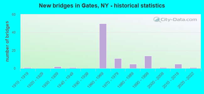
- New bridges - historical statistics
- 11910-1919
- 21930-1939
- 11940-1949
- 501960-1969
- 111970-1979
- 51980-1989
- 141990-1999
- 12000-2009
- 52010-2019
- 12020-2022
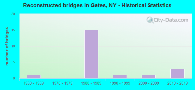
- Reconstructed bridges - Historical Statistics
- 11960-1969
- 01970-1979
- 151980-1989
- 11990-1999
- 12000-2009
- 32010-2019
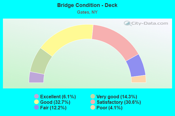
- Bridge Condition - Deck
- 6.1%Excellent
- 14.3%Very good
- 32.7%Good
- 30.6%Satisfactory
- 12.2%Fair
- 4.1%Poor
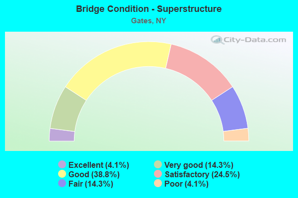
- Bridge Condition - Superstructure
- 4.1%Excellent
- 14.3%Very good
- 38.8%Good
- 24.5%Satisfactory
- 14.3%Fair
- 4.1%Poor
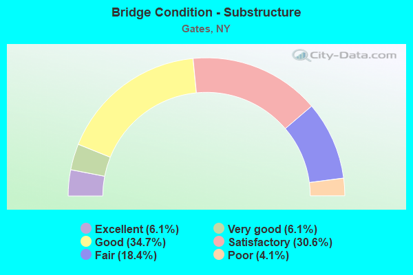
- Bridge Condition - Substructure
- 6.1%Excellent
- 6.1%Very good
- 34.7%Good
- 30.6%Satisfactory
- 18.4%Fair
- 4.1%Poor
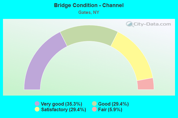
- Bridge Condition - Channel
- 35.3%Very good
- 29.4%Good
- 29.4%Satisfactory
- 5.9%Fair
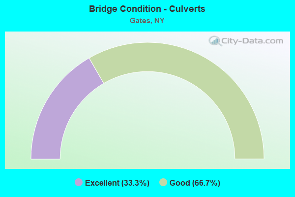
- Bridge Condition - Culverts
- 33.3%Excellent
- 66.7%Good
Find on map >> Show street view
Structure Number: 106395, Location: JCT RTS I490 WB + I590 SB (Lat: 43.156436, Lng: -77.678922), Route carried "on" structure: Interstate 390, Year Built: 1963, Year Reconstructed: 1991, Status: Open, Structure Length: 8.50m (27.89ft), Average Daily Traffic: 73,985 (year 2020), Truck Traffic: 6%, Average Future Daily Traffic: 102,890 (year 2040), Design Load: HS 20, Features Intersected: RTE I490, RAMPRAMP WB TO
Minimum Vertical Clearance: 30+ m (98+ ft), Kilometerpoint: 30.635, Lanes on structure: 3, Lanes under structure: 6, Base Highway Network: Yes, Owner: State Highway Agency, Approaching Roadway Width: 13.1m (43.0ft), Skew: 4 degrees, Material/Design: Steel, Design/Construction: Stringer/Multi-beam, Number Of Spans In Main Unit: 3, Length of Maximum Span: 31.0m (101.7ft), Curb-To-Curb Width: 12.2m (40.0ft), Out-to-Out Width: 13.2m (43.3ft)
Condition: Deck: Satisfactory, Superstructure: Fair, Substructure: Good, Operating Rating: 84.4 metric tons, Method Used To Determine Operating Rating: Load Factor (LF), Inventory Rating: 50.8 metric tons, Method Used To Determine Inventory Rating: Load Factor (LF), Structural Evaluation: Somewhat better than minimum adequacy, Deck Geometry: High priority of corrective action, Underclear: High priority of corrective action, Approach Roadway Alignment: Equal to present minimum criteria, Length Of Structure Improvement: 8.50m (27.89ft), Designated Inspection Frequency: Every 24 months, Inspection Date: December 2021, Bridge Improvement Cost: $2,704,000, Roadway Improvement Cost: $1,583,000, Total Project Cost: $4,287,000 ( Estimate for 2021), Deck Structure Type: Concrete Cast-file-Place, Wearing Surface/Protective System: Wearing Surface: Epoxy Overlay
Find on map >> Show street view
Structure Number: 107317, Location: RTE 386 OVER 490I - GATES (Lat: 43.158444, Lng: -77.732389), Route carried "on" structure: State highway 386, Year Built: 1986, Status: Open, Structure Length: 8.53m (27.99ft), Average Daily Traffic: 17,152 (year 2020), Truck Traffic: 4%, Average Future Daily Traffic: 20,836 (year 2040), Design Load: HS 20, Features Intersected: 531 531 43011011 WB, RTE
Minimum Vertical Clearance: 30+ m (98+ ft), Kilometerpoint: 18.632, Lanes on structure: 5, Lanes under structure: 6, Base Highway Network: Yes, Owner: State Highway Agency, Approaching Roadway Width: 21.9m (71.9ft), Skew: 21 degrees, Material/Design: Steel continuous, Design/Construction: Stringer/Multi-beam, Number Of Spans In Main Unit: 2, Length of Maximum Span: 42.3m (138.8ft), Curb-To-Curb Width: 20.7m (67.9ft), Out-to-Out Width: 21.6m (70.9ft)
Condition: Deck: Satisfactory, Superstructure: Satisfactory, Substructure: Fair, Operating Rating: 78.9 metric tons, Method Used To Determine Operating Rating: Load Factor (LF), Inventory Rating: 47.2 metric tons, Method Used To Determine Inventory Rating: Load Factor (LF), Structural Evaluation: Somewhat better than minimum adequacy, Deck Geometry: Somewhat better than minimum adequacy, Underclear: Meets minimum limits, Approach Roadway Alignment: Equal to present desirable criteria, Length Of Structure Improvement: 8.53m (27.99ft), Designated Inspection Frequency: Every 24 months, Inspection Date: March 2021, Bridge Improvement Cost: $4,467,000, Roadway Improvement Cost: $2,616,000, Total Project Cost: $7,082,000 ( Estimate for 2021), Deck Structure Type: Concrete Cast-file-Place, Wearing Surface/Protective System: Wearing Surface: Integral Concrete, Deck Protection: Epoxy Coated Reinforcing
Find on map >> Show street view
Structure Number: 107318, Location: MANITOU RD TO ELMGROVE RD (Lat: 43.160133, Lng: -77.744422), Route carried "on" structure: Ramp Other road , Year Built: 1986, Status: Open, Structure Length: 6.64m (21.78ft), Average Daily Traffic: 1,346 (year 2017), Truck Traffic: 10%, Average Future Daily Traffic: 1,404 (year 2040), Design Load: HS 20, Features Intersected: 531 531 43011004, RTE 53, Facility Carried by Structure: HAREK ROAD
Minimum Vertical Clearance: 30+ m (98+ ft), Kilometerpoint: 1.046, Lanes on structure: 2, Lanes under structure: 4, Owner: State Highway Agency, Approaching Roadway Width: 14.3m (46.9ft), Material/Design: Steel continuous, Design/Construction: Stringer/Multi-beam, Number Of Spans In Main Unit: 2, Length of Maximum Span: 32.0m (105.0ft), Curb-To-Curb Width: 14.0m (45.9ft), Out-to-Out Width: 14.9m (48.9ft)
Condition: Deck: Fair, Superstructure: Good, Substructure: Satisfactory, Operating Rating: 55.4 metric tons, Method Used To Determine Operating Rating: Load and Resistance Factor Rating (LRFR) rating reported by rating factor(RF) method using HL-93 loadings, Inventory Rating: 42.8 metric tons, Method Used To Determine Inventory Rating: Load and Resistance Factor Rating (LRFR) rating reported by rating factor(RF) method using HL-93 loadings, Structural Evaluation: Equal to present minimum criteria, Deck Geometry: Superior to present desirable criteria, Underclear: High priority of corrective action, Approach Roadway Alignment: Equal to present desirable criteria, Length Of Structure Improvement: 6.64m (21.78ft), Designated Inspection Frequency: Every 24 months, Inspection Date: July 2020, Bridge Improvement Cost: $2,459,000, Roadway Improvement Cost: $1,440,000, Total Project Cost: $3,898,000 ( Estimate for 2021), Deck Structure Type: Concrete Cast-file-Place, Wearing Surface/Protective System: Wearing Surface: Integral Concrete, Deck Protection: Epoxy Coated Reinforcing
Find on map >> Show street view
Structure Number: 10799, Location: South of Lyell Ave. (Lat: 43.159622, Lng: -77.679892), Route carried "on" structure: Ramp State highway , Year Built: 2019, Status: Open, Structure Length: 5.88m (19.29ft), Average Daily Traffic: 4,450 (year 2020), Average Future Daily Traffic: 4,641 (year 2040), Design Load: HL 93, Features Intersected: Drainage Culvert, Ramp E, Facility Carried by Structure: Ramp A
Minimum Vertical Clearance: 32.69m (107.25ft), Kilometerpoint: 0.145, Lanes on structure: 1, Lanes under structure: 2, Owner: State Highway Agency, Approaching Roadway Width: 7.6m (24.9ft), Skew: 3 degrees, Material/Design: Steel, Design/Construction: Stringer/Multi-beam, Number Of Spans In Main Unit: 1, Length of Maximum Span: 56.4m (185.0ft), Curb-To-Curb Width: 7.3m (24.0ft), Out-to-Out Width: 8.5m (27.9ft)
Condition: Deck: Very good, Superstructure: Very good, Substructure: Very good, Operating Rating: 61.9 metric tons, Method Used To Determine Operating Rating: Load and Resistance Factor Rating (LRFR) rating reported by rating factor(RF) method using HL-93 loadings, Inventory Rating: 47.6 metric tons, Method Used To Determine Inventory Rating: Load and Resistance Factor Rating (LRFR) rating reported by rating factor(RF) method using HL-93 loadings, Structural Evaluation: Equal to present desirable criteria, Deck Geometry: Better than present minimum criteria, Underclear: Meets minimum limits, Waterway Adequacy: Superior to present desirable criteria, Approach Roadway Alignment: Equal to present minimum criteria, Length Of Structure Improvement: 5.88m (19.29ft), Designated Inspection Frequency: Every 24 months, Inspection Date: September 2021, Bridge Improvement Cost: $1,567,000, Roadway Improvement Cost: $917,000, Total Project Cost: $2,484,000 ( Estimate for 2021), Deck Structure Type: Concrete Cast-file-Place, Wearing Surface/Protective System: Wearing Surface: Integral Concrete, Deck Protection: Epoxy Coated Reinforcing
Find on map >> Show street view
Structure Number: 109556, Location: JCT WBI490EXT+I490WB RAMP (Lat: 43.154958, Lng: -77.717203), Route carried "on" structure: Ramp State highway , Year Built: 1963, Year Reconstructed: 1993, Status: Open, Structure Length: 5.46m (17.91ft), Average Daily Traffic: 3,838 (year 2020), Truck Traffic: 7%, Average Future Daily Traffic: 5,337 (year 2040), Design Load: HS 20+Mod, Features Intersected: RTE I490, Facility Carried by Structure: RAMP D
Minimum Vertical Clearance: 30+ m (98+ ft), Kilometerpoint: 1.046, Lanes on structure: 2, Lanes under structure: 2, Owner: State Highway Agency, Approaching Roadway Width: 10.7m (35.1ft), Skew: 3 degrees, Material/Design: Steel, Design/Construction: Stringer/Multi-beam, Number Of Spans In Main Unit: 3, Length of Maximum Span: 21.0m (68.9ft), Curb-To-Curb Width: 9.1m (29.9ft), Out-to-Out Width: 11.0m (36.1ft)
Condition: Deck: Good, Superstructure: Good, Substructure: Satisfactory, Operating Rating: 80.7 metric tons, Method Used To Determine Operating Rating: Load Factor (LF), Inventory Rating: 48.1 metric tons, Method Used To Determine Inventory Rating: Load Factor (LF), Structural Evaluation: Equal to present minimum criteria, Deck Geometry: Meets minimum limits, Underclear: High priority of corrective action, Approach Roadway Alignment: Equal to present minimum criteria, Length Of Structure Improvement: 5.45m (17.88ft), Designated Inspection Frequency: Every 24 months, Inspection Date: March 2021, Bridge Improvement Cost: $1,428,000, Roadway Improvement Cost: $837,000, Total Project Cost: $2,265,000 ( Estimate for 2021), Deck Structure Type: Concrete Cast-file-Place, Wearing Surface/Protective System: Wearing Surface: Integral Concrete, Deck Protection: Epoxy Coated Reinforcing
Find on map >> Show street view
Structure Number: 109557, Location: 1.1MI E JCT I490EXT+386 (Lat: 43.157972, Lng: -77.711464), Route carried "on" structure: County highway , Year Built: 1963, Status: Open, Structure Length: 4.05m (13.29ft), Average Daily Traffic: 8,627 (year 2018), Truck Traffic: 2%, Average Future Daily Traffic: 10,674 (year 2040), Design Load: HS 20+Mod, Features Intersected: RTE I490, Facility Carried by Structure: WEGMAN ROAD
Minimum Vertical Clearance: 30+ m (98+ ft), Kilometerpoint: 1.062, Lanes on structure: 2, Lanes under structure: 3, Owner: State Highway Agency, Approaching Roadway Width: 9.8m (32.2ft), Material/Design: Steel, Design/Construction: Stringer/Multi-beam, Number Of Spans In Main Unit: 3, Length of Maximum Span: 16.7m (54.8ft), Curb or Sidewalk Widths: Left: 1.2m (3.9ft), Right: 1.2m (3.9ft), Curb-To-Curb Width: 7.3m (24.0ft), Out-to-Out Width: 10.4m (34.1ft)
Condition: Deck: Poor, Superstructure: Satisfactory, Substructure: Poor, Operating Rating: 80.7 metric tons, Method Used To Determine Operating Rating: Load Factor (LF), Inventory Rating: 48.1 metric tons, Method Used To Determine Inventory Rating: Load Factor (LF), Structural Evaluation: Meets minimum limits, Deck Geometry: High priority of replacement, Underclear: High priority of corrective action, Approach Roadway Alignment: Equal to present minimum criteria, Length Of Structure Improvement: 4.05m (13.29ft), Designated Inspection Frequency: Every 24 months, Inspection Date: April 2021, Bridge Improvement Cost: $1,025,000, Roadway Improvement Cost: $601,000, Total Project Cost: $1,626,000 ( Estimate for 2021), Deck Structure Type: Concrete Cast-file-Place, Wearing Surface/Protective System: Wearing Surface: Integral Concrete
Find on map >> Show street view
Structure Number: 225785, Location: 2 MI SW OF GATES CENTER (Lat: 43.129589, Lng: -77.715317), Route carried "on" structure: Other road , Year Built: 1973, Status: Open, Structure Length: 1.10m (3.61ft), Average Daily Traffic: 369 (year 2016), Truck Traffic: 3%, Average Future Daily Traffic: 517 (year 2036), Design Load: H 20, Features Intersected: LITTL BLACK CREEK, Facility Carried by Structure: HARPINGTON DRIVE
Minimum Vertical Clearance: 30+ m (98+ ft), Kilometerpoint: 0.434, Lanes on structure: 2, Owner: Town or Township Highway Agency, Approaching Roadway Width: 7.3m (24.0ft), Material/Design: Concrete, Design/Construction: Slab, Number Of Spans In Main Unit: 1, Length of Maximum Span: 10.3m (33.8ft), Curb or Sidewalk Widths: Left: 0.7m (2.3ft), Right: 0.7m (2.3ft), Curb-To-Curb Width: 7.3m (24.0ft), Out-to-Out Width: 9.2m (30.2ft)
Condition: Deck: Satisfactory, Superstructure: Satisfactory, Substructure: Satisfactory, Channel: Fair, Operating Rating: 49.9 metric tons, Method Used To Determine Operating Rating: Load Factor (LF), Inventory Rating: 29.9 metric tons, Method Used To Determine Inventory Rating: Load Factor (LF), Structural Evaluation: Equal to present minimum criteria, Deck Geometry: Somewhat better than minimum adequacy, Waterway Adequacy: Equal to present desirable criteria, Approach Roadway Alignment: Equal to present minimum criteria, Length Of Structure Improvement: 1.09m (3.58ft), Designated Inspection Frequency: Every 24 months, Inspection Date: May 2020, Bridge Improvement Cost: $296,000, Roadway Improvement Cost: $173,000, Total Project Cost: $469,000 ( Estimate for 2021), Wearing Surface/Protective System: Wearing Surface: Bituminous
Find on map >> Show street view
Structure Number: 331704, Location: 2 MILES SW OF GATES (Lat: 43.133253, Lng: -77.707572), Route carried "on" structure: County highway , Year Built: 1990, Status: Open, Structure Length: 0.88m (2.89ft), Average Daily Traffic: 4,603 (year 2020), Truck Traffic: 3%, Average Future Daily Traffic: 5,695 (year 2040), Design Load: HS 20, Features Intersected: LITTLE BLACK CREEK, Facility Carried by Structure: PIXLEY ROAD
Minimum Vertical Clearance: 30+ m (98+ ft), Kilometerpoint: 1.287, Lanes on structure: 2, Owner: County Highway Agency, Approaching Roadway Width: 11.0m (36.1ft), Skew: 2 degrees, Material/Design: Prestressed concrete, Design/Construction: Box Beam or Girders - Multiple, Number Of Spans In Main Unit: 1, Length of Maximum Span: 8.5m (27.9ft), Curb-To-Curb Width: 11.7m (38.4ft), Out-to-Out Width: 12.3m (40.4ft)
Condition: Deck: Good, Superstructure: Very good, Substructure: Good, Channel: Good, Operating Rating: 78.0 metric tons, Method Used To Determine Operating Rating: Load Factor (LF), Inventory Rating: 46.3 metric tons, Method Used To Determine Inventory Rating: Load Factor (LF), Structural Evaluation: Better than present minimum criteria, Deck Geometry: Somewhat better than minimum adequacy, Waterway Adequacy: Equal to present desirable criteria, Approach Roadway Alignment: Better than present minimum criteria, Length Of Structure Improvement: 0.88m (2.89ft), Designated Inspection Frequency: Every 24 months, Inspection Date: April 2020, Bridge Improvement Cost: $425,000, Roadway Improvement Cost: $249,000, Total Project Cost: $674,000 ( Estimate for 2021), Wearing Surface/Protective System: Wearing Surface: Bituminous, Membrane: Other
Find on map >> Show street view
Structure Number: 331749, Location: 2.5 MI SE OF GATES (Lat: 43.130853, Lng: -77.725731), Route carried "on" structure: Other road , Year Built: 1966, Year Reconstructed: 1995, Status: Open, Structure Length: 0.91m (2.99ft), Average Daily Traffic: 1,812 (year 2019), Truck Traffic: 6%, Average Future Daily Traffic: 2,537 (year 2039), Design Load: HS 25 or greater, Features Intersected: LITTLE BLACK CREEK, Facility Carried by Structure: TRABOLD ROAD
Minimum Vertical Clearance: 30+ m (98+ ft), Kilometerpoint: 1.496, Lanes on structure: 2, Owner: County Highway Agency, Approaching Roadway Width: 8.8m (28.9ft), Material/Design: Prestressed concrete, Design/Construction: Box Beam or Girders - Multiple, Number Of Spans In Main Unit: 1, Length of Maximum Span: 8.8m (28.9ft), Curb-To-Curb Width: 8.8m (28.9ft), Out-to-Out Width: 9.4m (30.8ft)
Condition: Deck: Satisfactory, Superstructure: Good, Substructure: Good, Channel: Satisfactory, Operating Rating: 32.1 metric tons, Method Used To Determine Operating Rating: Load and Resistance Factor Rating (LRFR) rating reported by rating factor(RF) method using HL-93 loadings, Inventory Rating: 23.7 metric tons, Method Used To Determine Inventory Rating: Load and Resistance Factor Rating (LRFR) rating reported by rating factor(RF) method using HL-93 loadings, Structural Evaluation: Equal to present minimum criteria, Deck Geometry: Somewhat better than minimum adequacy, Waterway Adequacy: Better than present minimum criteria, Approach Roadway Alignment: Better than present minimum criteria, Length Of Structure Improvement: 0.91m (2.99ft), Designated Inspection Frequency: Every 24 months, Inspection Date: March 2021, Bridge Improvement Cost: $254,000, Roadway Improvement Cost: $149,000, Total Project Cost: $402,000 ( Estimate for 2021), Wearing Surface/Protective System: Wearing Surface: Bituminous
Find on map >> Show street view
Structure Number: 4062531, Location: JCT ST BARGE C + RTE 47SB (Lat: 43.173594, Lng: -77.683419), Route carried "on" structure: State highway 390, Year Built: 1971, Year Reconstructed: 2019, Status: Open, Structure Length: 6.16m (20.21ft), Average Daily Traffic: 34,962 (year 2020), Truck Traffic: 5%, Average Future Daily Traffic: 36,468 (year 2040), Design Load: HS 20, Features Intersected: Canal Trailway, ERIE CAN
Minimum Vertical Clearance: 30+ m (98+ ft), Kilometerpoint: 1.931, Lanes on structure: 4, Base Highway Network: Yes, Owner: State Highway Agency, Approaching Roadway Width: 18.9m (62.0ft), Skew: 3 degrees, Navigation Control: Yes ( Vertical Clearance: 999.9m (3,280.5ft), Horizontal Clearance: 28.6m (93.8ft)), Material/Design: Steel, Design/Construction: Stringer/Multi-beam, Number Of Spans In Main Unit: 1, Length of Maximum Span: 59.7m (195.9ft), Curb-To-Curb Width: 19.1m (62.7ft), Out-to-Out Width: 20.0m (65.6ft)
Condition: Deck: Very good, Superstructure: Good, Substructure: Very good, Channel: Very good, Operating Rating: 75.3 metric tons, Method Used To Determine Operating Rating: Load Factor (LF), Inventory Rating: 45.4 metric tons, Method Used To Determine Inventory Rating: Load Factor (LF), Structural Evaluation: Better than present minimum criteria, Deck Geometry: Somewhat better than minimum adequacy, Waterway Adequacy: Superior to present desirable criteria, Approach Roadway Alignment: Equal to present desirable criteria, Length Of Structure Improvement: 6.15m (20.18ft), Designated Inspection Frequency: Every 24 months, Inspection Date: September 2021, Bridge Improvement Cost: $3,640,000, Roadway Improvement Cost: $2,132,000, Total Project Cost: $5,772,000 ( Estimate for 2021), Deck Structure Type: Concrete Cast-file-Place, Wearing Surface/Protective System: Wearing Surface: Integral Concrete, Deck Protection: Epoxy Coated Reinforcing
Find on map >> Show street view
Structure Number: 4062532, Location: JCT ST BARGE C + RTE 47NB (Lat: 43.173800, Lng: -77.683164), Route carried "on" structure: State highway 390, Year Built: 1971, Year Reconstructed: 2019, Status: Open, Structure Length: 6.16m (20.21ft), Average Daily Traffic: 34,962 (year 2020), Truck Traffic: 5%, Average Future Daily Traffic: 36,468 (year 2040), Design Load: HS 20, Features Intersected: Canal Trailway, ERIE CAN
Minimum Vertical Clearance: 30+ m (98+ ft), Kilometerpoint: 1.931, Lanes on structure: 4, Base Highway Network: Yes, Owner: State Highway Agency, Approaching Roadway Width: 19.5m (64.0ft), Skew: 3 degrees, Navigation Control: Yes ( Vertical Clearance: 999.9m (3,280.5ft), Horizontal Clearance: 28.6m (93.8ft)), Material/Design: Steel, Design/Construction: Stringer/Multi-beam, Number Of Spans In Main Unit: 1, Length of Maximum Span: 59.7m (195.9ft), Curb-To-Curb Width: 19.5m (64.0ft), Out-to-Out Width: 20.4m (66.9ft)
Condition: Deck: Excellent, Superstructure: Good, Substructure: Very good, Channel: Very good, Operating Rating: 69.9 metric tons, Method Used To Determine Operating Rating: Load Factor (LF), Inventory Rating: 32.7 metric tons, Method Used To Determine Inventory Rating: Load Factor (LF), Structural Evaluation: Better than present minimum criteria, Deck Geometry: Somewhat better than minimum adequacy, Waterway Adequacy: Superior to present desirable criteria, Approach Roadway Alignment: Equal to present desirable criteria, Length Of Structure Improvement: 6.15m (20.18ft), Designated Inspection Frequency: Every 24 months, Inspection Date: September 2021, Bridge Improvement Cost: $3,856,000, Roadway Improvement Cost: $2,258,000, Total Project Cost: $6,114,000 ( Estimate for 2021), Deck Structure Type: Concrete Cast-file-Place, Wearing Surface/Protective System: Wearing Surface: Integral Concrete, Deck Protection: Epoxy Coated Reinforcing
Find on map >> Show street view
Structure Number: 444311, Location: 0.6MI NW JCT ERIE C. + 31 (Lat: 43.172453, Lng: -77.680686), Route carried "on" structure: County highway , Year Built: 1990, Status: Open, Structure Length: 6.64m (21.78ft), Average Daily Traffic: 16,342 (year 2019), Truck Traffic: 4%, Average Future Daily Traffic: 19,852 (year 2040), Design Load: HS 20, Features Intersected: ERIE CANAL, BIKEWAY, Facility Carried by Structure: LEE ROAD
Minimum Vertical Clearance: 30+ m (98+ ft), Kilometerpoint: 0.772, Lanes on structure: 4, Owner: State Highway Agency, Approaching Roadway Width: 15.2m (49.9ft), Skew: 4 degrees, Navigation Control: Yes ( Vertical Clearance: 4.5m (14.8ft), Horizontal Clearance: 28.6m (93.8ft)), Material/Design: Steel, Design/Construction: Stringer/Multi-beam, Number Of Spans In Main Unit: 1, Length of Maximum Span: 64.3m (211.0ft), Curb or Sidewalk Widths: Left: 0.0m, Right: 1.5m (4.9ft), Curb-To-Curb Width: 15.2m (49.9ft), Out-to-Out Width: 17.5m (57.4ft)
Condition: Deck: Very good, Superstructure: Very good, Substructure: Good, Channel: Very good, Operating Rating: 89.8 metric tons, Method Used To Determine Operating Rating: Load Factor (LF), Inventory Rating: 60.8 metric tons, Method Used To Determine Inventory Rating: Load Factor (LF), Structural Evaluation: Better than present minimum criteria, Deck Geometry: High priority of corrective action, Waterway Adequacy: Superior to present desirable criteria, Approach Roadway Alignment: Equal to present desirable criteria, Length Of Structure Improvement: 6.64m (21.78ft), Designated Inspection Frequency: Every 24 months, Inspection Date: July 2020, Bridge Improvement Cost: $3,294,000, Roadway Improvement Cost: $1,929,000, Total Project Cost: $5,223,000 ( Estimate for 2021), Deck Structure Type: Concrete Cast-file-Place, Wearing Surface/Protective System: Wearing Surface: Integral Concrete, Deck Protection: Epoxy Coated Reinforcing
Find on map >> Show street view
Structure Number: 444334, Location: JCT BARGE C + RTE 33A (Lat: 43.140175, Lng: -77.666094), Route carried "on" structure: Alternate State highway 33A, Year Built: 1940, Year Reconstructed: 1966, Status: Posted for load-capacity, Structure Length: 4.69m (15.39ft), Average Daily Traffic: 14,319 (year 2019), Truck Traffic: 3%, Average Future Daily Traffic: 17,394 (year 2040), Design Load: HS 20+Mod, Features Intersected: ERIE CANAL
Minimum Vertical Clearance: 4.65m (15.26ft), Kilometerpoint: 24.521, Lanes on structure: 4, Base Highway Network: Yes, Owner: State Highway Agency, Approaching Roadway Width: 12.8m (42.0ft), Navigation Control: Yes ( Vertical Clearance: 999.9m (3,280.5ft), Horizontal Clearance: 28.6m (93.8ft)), Material/Design: Steel, Design/Construction: Truss - Thru, Number Of Spans In Main Unit: 1, Length of Maximum Span: 45.1m (148.0ft), Curb or Sidewalk Widths: Left: 1.9m (6.2ft), Right: 1.9m (6.2ft), Curb-To-Curb Width: 12.8m (42.0ft), Out-to-Out Width: 13.5m (44.3ft)
Condition: Deck: Fair, Superstructure: Poor, Substructure: Good, Channel: Good, Operating Rating: 41.7 metric tons, Method Used To Determine Operating Rating: Load Factor (LF), Inventory Rating: 24.5 metric tons, Method Used To Determine Inventory Rating: Load Factor (LF), Structural Evaluation: Meets minimum limits, Deck Geometry: High priority of replacement, Waterway Adequacy: Equal to present minimum criteria, Approach Roadway Alignment: Equal to present minimum criteria, Length Of Structure Improvement: 4.69m (15.39ft), Designated Inspection Frequency: Every 24 months, Critical Feature Inspection Frequency: Every 12 months, Inspection Date: September 2021, Critical Feature Inspection Date: September 2021, Bridge Improvement Cost: $4,868,000, Roadway Improvement Cost: $2,850,000, Total Project Cost: $7,718,000 ( Estimate for 2021), Deck Structure Type: Concrete Cast-file-Place, Wearing Surface/Protective System: Wearing Surface: Latex Concrete
Find on map >> Show street view
Structure Number: 4443361, Location: JCT BARGE C + RTE I490 WB (Lat: 43.157758, Lng: -77.673989), Route carried "on" structure: Interstate 490, Year Built: 1963, Year Reconstructed: 1991, Status: Open, Structure Length: 4.63m (15.19ft), Average Daily Traffic: 7,633 (year 2020), Truck Traffic: 11%, Average Future Daily Traffic: 10,615 (year 2040), Design Load: HS 20, Features Intersected: Pathway, ERIE CANAL
Minimum Vertical Clearance: 30+ m (98+ ft), Kilometerpoint: 0.241, Lanes on structure: 4, Owner: State Highway Agency, Approaching Roadway Width: 18.6m (61.0ft), Skew: 1 degrees, Navigation Control: Yes ( Vertical Clearance: 4.5m (14.8ft), Horizontal Clearance: 28.6m (93.8ft)), Material/Design: Steel, Design/Construction: Stringer/Multi-beam, Number Of Spans In Main Unit: 1, Length of Maximum Span: 45.7m (149.9ft), Curb-To-Curb Width: 18.6m (61.0ft), Out-to-Out Width: 19.2m (63.0ft)
Condition: Deck: Satisfactory, Superstructure: Fair, Substructure: Fair, Channel: Very good, Operating Rating: 84.4 metric tons, Method Used To Determine Operating Rating: Load Factor (LF), Inventory Rating: 43.5 metric tons, Method Used To Determine Inventory Rating: Load Factor (LF), Structural Evaluation: Somewhat better than minimum adequacy, Deck Geometry: Meets minimum limits, Waterway Adequacy: Equal to present minimum criteria, Approach Roadway Alignment: Equal to present minimum criteria, Length Of Structure Improvement: 4.63m (15.19ft), Designated Inspection Frequency: Every 24 months, Inspection Date: November 2020, Bridge Improvement Cost: $2,595,000, Roadway Improvement Cost: $1,519,000, Total Project Cost: $4,114,000 ( Estimate for 2021), Deck Structure Type: Concrete Cast-file-Place, Wearing Surface/Protective System: Wearing Surface: Integral Concrete, Deck Protection: Epoxy Coated Reinforcing
Find on map >> Show street view
Structure Number: 4443362, Location: JCT BARGE C + RTE I490 EB (Lat: 43.157119, Lng: -77.673919), Route carried "on" structure: Interstate 490, Year Built: 1963, Year Reconstructed: 1991, Status: Open, Structure Length: 4.63m (15.19ft), Average Daily Traffic: 31,445 (year 2018), Truck Traffic: 5%, Average Future Daily Traffic: 43,730 (year 2040), Design Load: HS 20, Features Intersected: Pathway, ERIE CANAL
Minimum Vertical Clearance: 30+ m (98+ ft), Kilometerpoint: 29.059, Lanes on structure: 5, Base Highway Network: Yes, Owner: State Highway Agency, Approaching Roadway Width: 20.4m (66.9ft), Navigation Control: Yes ( Vertical Clearance: 4.5m (14.8ft), Horizontal Clearance: 28.6m (93.8ft)), Material/Design: Steel, Design/Construction: Stringer/Multi-beam, Number Of Spans In Main Unit: 1, Length of Maximum Span: 45.7m (149.9ft), Curb-To-Curb Width: 22.3m (73.2ft), Out-to-Out Width: 22.9m (75.1ft)
Condition: Deck: Good, Superstructure: Satisfactory, Substructure: Satisfactory, Channel: Very good, Operating Rating: 84.4 metric tons, Method Used To Determine Operating Rating: Load Factor (LF), Inventory Rating: 43.5 metric tons, Method Used To Determine Inventory Rating: Load Factor (LF), Structural Evaluation: Equal to present minimum criteria, Deck Geometry: Meets minimum limits, Waterway Adequacy: Superior to present desirable criteria, Approach Roadway Alignment: Equal to present minimum criteria, Length Of Structure Improvement: 4.63m (15.19ft), Designated Inspection Frequency: Every 24 months, Inspection Date: November 2020, Bridge Improvement Cost: $3,181,000, Roadway Improvement Cost: $1,863,000, Total Project Cost: $5,044,000 ( Estimate for 2021), Deck Structure Type: Concrete Cast-file-Place, Wearing Surface/Protective System: Wearing Surface: Integral Concrete, Deck Protection: Epoxy Coated Reinforcing
Find on map >> Show street view
Structure Number: 444338, Location: JCT BARGEC+31 W SIDE ROCH (Lat: 43.164700, Lng: -77.676456), Route carried "on" structure: State highway 31, Year Built: 1937, Status: Open, Structure Length: 3.60m (11.81ft), Average Daily Traffic: 12,139 (year 2019), Truck Traffic: 10%, Average Future Daily Traffic: 14,746 (year 2040), Design Load: HS 20, Features Intersected: ERIE CANAL
Minimum Vertical Clearance: 30+ m (98+ ft), Kilometerpoint: 29.493, Lanes on structure: 2, Base Highway Network: Yes, Owner: State Highway Agency, Approaching Roadway Width: 12.2m (40.0ft), Skew: 1 degrees, Navigation Control: Yes ( Vertical Clearance: 5.5m (18.0ft), Horizontal Clearance: 25.6m (84.0ft)), Material/Design: Steel, Design/Construction: Truss - Thru, Number Of Spans In Main Unit: 1, Length of Maximum Span: 34.4m (112.9ft), Curb or Sidewalk Widths: Left: 1.8m (5.9ft), Right: 1.8m (5.9ft), Curb-To-Curb Width: 12.2m (40.0ft), Out-to-Out Width: 12.9m (42.3ft)
Condition: Deck: Fair, Superstructure: Poor, Substructure: Fair, Channel: Good, Operating Rating: 97.2 metric tons, Method Used To Determine Operating Rating: Field evaluation and documented engineering judgment, Inventory Rating: 32.7 metric tons, Method Used To Determine Inventory Rating: Field evaluation and documented engineering judgment, Structural Evaluation: Meets minimum limits, Deck Geometry: Somewhat better than minimum adequacy, Waterway Adequacy: Equal to present minimum criteria, Approach Roadway Alignment: Equal to present minimum criteria, Length Of Structure Improvement: 3.59m (11.78ft), Designated Inspection Frequency: Every 24 months, Critical Feature Inspection Frequency: Every 12 months, Inspection Date: August 2021, Critical Feature Inspection Date: August 2021, Bridge Improvement Cost: $4,605,000, Roadway Improvement Cost: $2,697,000, Total Project Cost: $7,302,000 ( Estimate for 2021), Deck Structure Type: Concrete Cast-file-Place, Wearing Surface/Protective System: Wearing Surface: Monolithic Concrete
Find on map >> Show street view
Structure Number: 444341, Location: JCT NYS BARGE C + RTE 204 (Lat: 43.130875, Lng: -77.658417), Route carried "on" structure: State highway 204, Year Built: 1989, Status: Open, Structure Length: 8.99m (29.49ft), Average Daily Traffic: 12,290 (year 2019), Truck Traffic: 3%, Average Future Daily Traffic: 14,929 (year 2040), Design Load: HS 20, Features Intersected: Erie Canalway Trail, Eri
Minimum Vertical Clearance: 30+ m (98+ ft), Kilometerpoint: 5.326, Lanes on structure: 4, Base Highway Network: Yes, Owner: State Highway Agency, Approaching Roadway Width: 16.5m (54.1ft), Skew: 3 degrees, Navigation Control: Yes ( Vertical Clearance: 10.3m (33.8ft), Horizontal Clearance: 28.6m (93.8ft)), Material/Design: Steel continuous, Design/Construction: Frame, Number Of Spans In Main Unit: 3, Length of Maximum Span: 34.1m (111.9ft), Curb or Sidewalk Widths: Left: 1.5m (4.9ft), Right: 1.5m (4.9ft), Curb-To-Curb Width: 16.5m (54.1ft), Out-to-Out Width: 20.1m (65.9ft)
Condition: Deck: Good, Superstructure: Very good, Substructure: Satisfactory, Channel: Very good, Operating Rating: 91.7 metric tons, Method Used To Determine Operating Rating: Field evaluation and documented engineering judgment, Inventory Rating: 32.7 metric tons, Method Used To Determine Inventory Rating: Field evaluation and documented engineering judgment, Structural Evaluation: Equal to present minimum criteria, Deck Geometry: Meets minimum limits, Waterway Adequacy: Superior to present desirable criteria, Approach Roadway Alignment: Equal to present desirable criteria, Length Of Structure Improvement: 8.99m (29.49ft), Designated Inspection Frequency: Every 24 months, Inspection Date: July 2021, Bridge Improvement Cost: $4,557,000, Roadway Improvement Cost: $2,669,000, Total Project Cost: $7,226,000 ( Estimate for 2021), Deck Structure Type: Concrete Cast-file-Place, Wearing Surface/Protective System: Wearing Surface: Integral Concrete, Deck Protection: Epoxy Coated Reinforcing
Find on map >> Show street view
Structure Number: 1021589, Location: JCT RTS31+47 LYELL AVE (Lat: 43.164697, Lng: -77.683044), Route carried "under" structure: Interstate 390, Year Built: 2018, Structure Length: 0. m, Average Daily Traffic: 97,604 (year 2015), Features Intersected: 390 390 43011005, RTE 39, Facility Carried by Structure: RTE 31
Minimum Vertical Clearance: 4.42m (14.50ft), Kilometerpoint: 0.805, Lanes on structure: 6, Lanes under structure: 4, Material/Design: Steel, Design/Construction: Stringer/Multi-beam, Length of Maximum Span: 33.5m (109.9ft)
Find on map >> Show street view
Structure Number: 1023021, Location: JCT RTS I490SB+33 GATES (Lat: 43.145269, Lng: -77.717972), Route carried "under" structure: State highway 33, Year Built: 1963, Structure Length: 0. m, Average Daily Traffic: 15,490 (year 1999), Features Intersected: 33 33 43031117 WB, RTE, Facility Carried by Structure: RTE I490
Minimum Vertical Clearance: 4.45m (14.60ft), Kilometerpoint: 18.890, Lanes on structure: 4, Lanes under structure: 3, Material/Design: Steel, Design/Construction: Stringer/Multi-beam, Length of Maximum Span: 18.2m (59.7ft)
Find on map >> Show street view
Structure Number: 1023022, Location: JCT RTS I490NB+33 GATES (Lat: 43.145478, Lng: -77.717283), Route carried "under" structure: State highway 33, Year Built: 1963, Structure Length: 0. m, Average Daily Traffic: 15,490 (year 1999), Features Intersected: 33 33 43031117 WB, RTE, Facility Carried by Structure: RTE I490
Minimum Vertical Clearance: 4.60m (15.09ft), Kilometerpoint: 18.890, Lanes on structure: 4, Lanes under structure: 3, Material/Design: Steel, Design/Construction: Stringer/Multi-beam, Length of Maximum Span: 18.2m (59.7ft)
Find on map >> Show street view
Structure Number: 1023101, Location: JCT.ROCH.OUT.LOOP NB& 33A (Lat: 43.139511, Lng: -77.668025), Route carried "under" structure: Alternate State highway 33A, Year Built: 1979, Structure Length: 0. m, Average Daily Traffic: 13,120 (year 1998), Features Intersected: RTE 33A, Facility Carried by Structure: RTE I390
Minimum Vertical Clearance: 5.05m (16.57ft), Kilometerpoint: 24.425, Lanes on structure: 4, Lanes under structure: 4, Material/Design: Steel, Design/Construction: Stringer/Multi-beam, Length of Maximum Span: 43.6m (143.0ft)
Find on map >> Show street view
Structure Number: 1023102, Location: JCT.ROCH.OUT.LOOP SB& 33A (Lat: 43.139411, Lng: -77.668319), Route carried "under" structure: Alternate State highway 33A, Year Built: 1979, Structure Length: 0. m, Average Daily Traffic: 13,120 (year 1998), Features Intersected: RTE 33A, Facility Carried by Structure: RTE I390
Minimum Vertical Clearance: 4.90m (16.08ft), Kilometerpoint: 24.425, Lanes on structure: 4, Lanes under structure: 4, Material/Design: Steel, Design/Construction: Stringer/Multi-beam, Length of Maximum Span: 43.5m (142.7ft)
Find on map >> Show street view
Structure Number: 1025811, Location: JCT RTSI490WB+47SB GATES (Lat: 43.158367, Lng: -77.682183), Route carried "under" structure: Interstate 390, Year Built: 1961, Structure Length: 0. m, Average Daily Traffic: 10,864 (year 2002), Features Intersected: RTE 390, I490EB TO 390 N, Facility Carried by Structure: RTE I490
Minimum Vertical Clearance: 4.60m (15.09ft), Kilometerpoint: 6.919, Lanes on structure: 3, Lanes under structure: 2, Material/Design: Steel, Design/Construction: Stringer/Multi-beam, Length of Maximum Span: 17.6m (57.7ft)
Find on map >> Show street view
Structure Number: 1025811, Location: JCT RTSI490WB+47SB GATES (Lat: 43.158367, Lng: -77.682183), Route carried "under" structure: Other road , Year Built: 1961, Structure Length: 0. m, Average Daily Traffic: 100 (year 2021), Features Intersected: RTE 390, I490EB TO 390 N, Facility Carried by Structure: RTE I490
Minimum Vertical Clearance: 30+ m (98+ ft), Kilometerpoint: 0.000, Lanes on structure: 3, Lanes under structure: 2, Material/Design: Steel, Design/Construction: Stringer/Multi-beam, Length of Maximum Span: 17.6m (57.7ft)
Find on map >> Show street view
Structure Number: 1025812, Location: JCT RTSI490EB+47SB GATES (Lat: 43.156306, Lng: -77.681778), Route carried "under" structure: Interstate 390, Year Built: 1963, Structure Length: 0. m, Average Daily Traffic: 44,485 (year 2015), Features Intersected: RTE I390, Facility Carried by Structure: RTE I490
Minimum Vertical Clearance: 4.65m (15.26ft), Kilometerpoint: 125.019, Lanes on structure: 2, Lanes under structure: 2, Material/Design: Steel, Design/Construction: Stringer/Multi-beam, Length of Maximum Span: 13.7m (44.9ft)
Find on map >> Show street view
Structure Number: 102582, Location: JCT RTSI490WB+47NB GATES (Lat: 43.156403, Lng: -77.679094), Route carried "under" structure: Interstate 390, Year Built: 1963, Structure Length: 0. m, Average Daily Traffic: 105,390 (year 1990), Features Intersected: RTE I390, RTE I490, Facility Carried by Structure: RTE I490
Minimum Vertical Clearance: 30+ m (98+ ft), Kilometerpoint: 0.000, Lanes on structure: 4, Lanes under structure: 3, Material/Design: Steel, Design/Construction: Stringer/Multi-beam, Length of Maximum Span: 22.2m (72.8ft)
Find on map >> Show street view
Structure Number: 102582, Location: JCT RTSI490WB+47NB GATES (Lat: 43.156403, Lng: -77.679094), Route carried "under" structure: Ramp Interstate 490, Year Built: 1963, Structure Length: 0. m, Average Daily Traffic: 8,855 (year 2009), Features Intersected: RTE I390, RTE I490
Minimum Vertical Clearance: 4.67m (15.32ft), Kilometerpoint: 0.000, Lanes on structure: 4, Lanes under structure: 2, Material/Design: Steel, Design/Construction: Stringer/Multi-beam, Length of Maximum Span: 22.2m (72.8ft)
Find on map >> Show street view
Structure Number: 1025851, Location: .2 M SW JCT RT 33A&390I N (Lat: 43.137650, Lng: -77.665964), Route carried "under" structure: County highway , Year Built: 1997, Structure Length: 0. m, Average Daily Traffic: 1,219 (year 2019), Truck Traffic: 4%, Features Intersected: BUELL ROAD, Facility Carried by Structure: RTE I390
Minimum Vertical Clearance: 4.78m (15.68ft), Kilometerpoint: 0.724, Lanes on structure: 4, Lanes under structure: 2, Material/Design: Steel continuous, Design/Construction: Stringer/Multi-beam, Length of Maximum Span: 28.3m (92.8ft)
Find on map >> Show street view
Structure Number: 1025852, Location: .2 M SW JCT 33A & 390I SB (Lat: 43.137256, Lng: -77.665947), Route carried "under" structure: County highway , Year Built: 1997, Structure Length: 0. m, Average Daily Traffic: 1,219 (year 2019), Truck Traffic: 4%, Features Intersected: Buell Road, Facility Carried by Structure: RTE I390
Minimum Vertical Clearance: 4.78m (15.68ft), Kilometerpoint: 0.145, Lanes on structure: 4, Lanes under structure: 2, Material/Design: Steel continuous, Design/Construction: Stringer/Multi-beam, Length of Maximum Span: 29.8m (97.8ft)
Find on map >> Show street view
Structure Number: 1025869, Location: 0.6MI SE JCT RTS47+33A (Lat: 43.130850, Lng: -77.661194), Route carried "under" structure: Interstate 390, Year Built: 1963, Structure Length: 0. m, Average Daily Traffic: 27,100 (year 1971), Features Intersected: 390I390I43037000 NB, RTE, Facility Carried by Structure: RTE 204
Minimum Vertical Clearance: 4.72m (15.49ft), Kilometerpoint: 27.514, Lanes on structure: 6, Lanes under structure: 4, Material/Design: Steel, Design/Construction: Stringer/Multi-beam, Length of Maximum Span: 23.1m (75.8ft)
Find on map >> Show street view
Structure Number: 1040261, Location: 1.6 MI NE JCT I490S&SH251 (Lat: 43.133953, Lng: -77.720042), Route carried "under" structure: State highway 204, Year Built: 1963, Structure Length: 0. m, Average Daily Traffic: 9,053 (year 2002), Features Intersected: 204 204 43011000WB, RTE, Facility Carried by Structure: RTE I490
Minimum Vertical Clearance: 4.44m (14.57ft), Kilometerpoint: 0.000, Lanes on structure: 3, Lanes under structure: 2, Material/Design: Steel, Design/Construction: Stringer/Multi-beam, Length of Maximum Span: 16.8m (55.1ft)
Find on map >> Show street view
Structure Number: 1040262, Location: 1.6 MI NE JCT I490N&SH251 (Lat: 43.133894, Lng: -77.719361), Route carried "under" structure: State highway 204, Year Built: 1963, Structure Length: 0. m, Average Daily Traffic: 6,484 (year 2015), Features Intersected: 204 204 43011000WB, RTE, Facility Carried by Structure: RTE I490
Minimum Vertical Clearance: 4.57m (14.99ft), Kilometerpoint: 0.161, Lanes on structure: 2, Lanes under structure: 2, Material/Design: Steel, Design/Construction: Stringer/Multi-beam, Length of Maximum Span: 15.8m (51.8ft)
Find on map >> Show street view
Structure Number: 1040291, Location: .5 MI SE JCT RTS 204+I490 (Lat: 43.130031, Lng: -77.710431), Route carried "under" structure: County highway , Year Built: 1993, Structure Length: 0. m, Average Daily Traffic: 2,302 (year 2020), Truck Traffic: 3%, Features Intersected: PIXLEY ROAD, Facility Carried by Structure: RTE 204
Minimum Vertical Clearance: 4.62m (15.16ft), Kilometerpoint: 0.805, Lanes on structure: 2, Lanes under structure: 2, Material/Design: Steel, Design/Construction: Stringer/Multi-beam, Length of Maximum Span: 30.5m (100.1ft)
Find on map >> Show street view
Structure Number: 1040292, Location: .5 MI SE JCT RTS 204+I490 (Lat: 43.129819, Lng: -77.710567), Route carried "under" structure: County highway , Year Built: 1993, Structure Length: 0. m, Average Daily Traffic: 2,302 (year 2020), Truck Traffic: 3%, Features Intersected: PIXLEY ROAD, Facility Carried by Structure: RTE 204
Minimum Vertical Clearance: 4.95m (16.24ft), Kilometerpoint: 0.692, Lanes on structure: 2, Lanes under structure: 2, Material/Design: Steel, Design/Construction: Stringer/Multi-beam, Length of Maximum Span: 30.4m (99.7ft)
Find on map >> Show street view
Structure Number: 104862, Location: 1.5MI S JCT RTS I490 + 33 (Lat: 43.125506, Lng: -77.729994), Route carried "under" structure: Interstate 490, Year Built: 1963, Structure Length: 0. m, Average Daily Traffic: 37,417 (year 2014), Features Intersected: 490I490I43021137 EB, RTE, Facility Carried by Structure: W SIDE DRIVE
Minimum Vertical Clearance: 4.39m (14.40ft), Kilometerpoint: 22.043, Lanes on structure: 2, Lanes under structure: 2, Material/Design: Steel, Design/Construction: Stringer/Multi-beam, Length of Maximum Span: 25.6m (84.0ft)
Find on map >> Show street view
Structure Number: 104865, Location: 0.6MI N JCT I490+33 RAMP (Lat: 43.153911, Lng: -77.716419), Route carried "under" structure: Interstate 490, Year Built: 1963, Structure Length: 0. m, Average Daily Traffic: 57,111 (year 2009), Features Intersected: RTE I490, Facility Carried by Structure: RAMP D TO 531 WB
Minimum Vertical Clearance: 4.78m (15.68ft), Kilometerpoint: 25.277, Lanes on structure: 2, Lanes under structure: 2, Material/Design: Steel continuous, Design/Construction: Stringer/Multi-beam, Length of Maximum Span: 21.0m (68.9ft)
Find on map >> Show street view
Structure Number: 104866, Location: 0.6MI N JCT I490+33 EB (Lat: 43.156050, Lng: -77.716289), Route carried "under" structure: Interstate 490, Year Built: 1963, Structure Length: 0. m, Average Daily Traffic: 89,284 (year 2002), Features Intersected: RTE I490, Facility Carried by Structure: RTE 531
Minimum Vertical Clearance: 4.52m (14.83ft), Kilometerpoint: 25.615, Lanes on structure: 2, Lanes under structure: 2, Material/Design: Steel, Design/Construction: Stringer/Multi-beam, Length of Maximum Span: 23.7m (77.8ft)
Find on map >> Show street view
Structure Number: 104867, Location: 1.1MI E JCT I490EXT+386 (Lat: 43.157275, Lng: -77.711461), Route carried "under" structure: Interstate 490, Year Built: 1963, Structure Length: 0. m, Average Daily Traffic: 89,284 (year 2002), Features Intersected: RTE I490, Facility Carried by Structure: WEGMAN ROAD
Minimum Vertical Clearance: 5.25m (17.22ft), Kilometerpoint: 27.498, Lanes on structure: 2, Lanes under structure: 3, Material/Design: Steel, Design/Construction: Stringer/Multi-beam, Length of Maximum Span: 21.3m (69.9ft)
Find on map >> Show street view
Structure Number: 104868, Location: 2.1 MI E JCT 490EXT & 386 (Lat: 43.157233, Lng: -77.691064), Route carried "under" structure: Interstate 490, Year Built: 1991, Structure Length: 0. m, Average Daily Traffic: 89,284 (year 2002), Features Intersected: 490I490I43021172 WB, RTE, Facility Carried by Structure: RTE 940L
Minimum Vertical Clearance: 4.57m (14.99ft), Kilometerpoint: 27.691, Lanes on structure: 2, Lanes under structure: 3, Material/Design: Steel continuous, Design/Construction: Stringer/Multi-beam, Length of Maximum Span: 30.1m (98.8ft)
Find on map >> Show street view
Structure Number: 105039, Location: 0.7MI E I490EXT + RTE 386 (Lat: 43.156106, Lng: -77.718156), Route carried "under" structure: Ramp Interstate , Year Built: 1963, Structure Length: 0. m, Average Daily Traffic: 2,500 (year 1975), Features Intersected: 490I EB TO 531 WB, Facility Carried by Structure: RTE 531
Minimum Vertical Clearance: 4.95m (16.24ft), Kilometerpoint: 27.627, Lanes on structure: 2, Lanes under structure: 2, Material/Design: Steel, Design/Construction: Stringer/Multi-beam, Length of Maximum Span: 22.3m (73.2ft)
Find on map >> Show street view
Structure Number: 105228, Location: EBI490 WEST TO ROCH OUT L (Lat: 43.158389, Lng: -77.682347), Route carried "under" structure: Interstate 390, Year Built: 1961, Structure Length: 0. m, Average Daily Traffic: 44,485 (year 2015), Features Intersected: RTE I390, RTE I490
Minimum Vertical Clearance: 4.62m (15.16ft), Kilometerpoint: 0.032, Lanes on structure: 1, Lanes under structure: 3, Material/Design: Steel, Design/Construction: Stringer/Multi-beam, Length of Maximum Span: 33.5m (109.9ft)
Find on map >> Show street view
Structure Number: 105228, Location: EBI490 WEST TO ROCH OUT L (Lat: 43.158389, Lng: -77.682347), Route carried "under" structure: Interstate 490, Year Built: 1961, Structure Length: 0. m, Average Daily Traffic: 60,235 (year 2015), Features Intersected: RTE I390, RTE I490
Minimum Vertical Clearance: 4.32m (14.17ft), Kilometerpoint: 28.479, Lanes on structure: 1, Lanes under structure: 3, Material/Design: Steel, Design/Construction: Stringer/Multi-beam, Length of Maximum Span: 33.5m (109.9ft)
Find on map >> Show street view
Structure Number: 105229, Location: OUTER LOOP NB +I490WB JCT (Lat: 43.158253, Lng: -77.679458), Route carried "under" structure: Interstate 490, Year Built: 1963, Structure Length: 0. m, Average Daily Traffic: 101,844 (year 2015), Features Intersected: RTE I490, Facility Carried by Structure: RTE 390
Minimum Vertical Clearance: 4.85m (15.91ft), Kilometerpoint: 28.688, Lanes on structure: 3, Lanes under structure: 2, Material/Design: Steel, Design/Construction: Stringer/Multi-beam, Length of Maximum Span: 17.1m (56.1ft)
Find on map >> Show street view
Structure Number: 1062521, Location: 2.0MI S JCT ROL SB + 104 (Lat: 43.178664, Lng: -77.683731), Route carried "under" structure: City street , Year Built: 1971, Structure Length: 0. m, Average Daily Traffic: 3,000 (year 1976), Features Intersected: LEXINGTON AVENUE, Facility Carried by Structure: RTE 390
Minimum Vertical Clearance: 4.50m (14.76ft), Kilometerpoint: 0.000, Lanes on structure: 4, Lanes under structure: 4, Material/Design: Steel, Design/Construction: Stringer/Multi-beam, Length of Maximum Span: 27.4m (89.9ft)
Find on map >> Show street view
Structure Number: 1062522, Location: 2.0MI S JCT ROL NB + 104 (Lat: 43.178744, Lng: -77.683389), Route carried "under" structure: City street , Year Built: 1971, Structure Length: 0. m, Average Daily Traffic: 3,000 (year 1976), Features Intersected: LEXINGTON AVENUE, Facility Carried by Structure: RTE 390
Minimum Vertical Clearance: 4.52m (14.83ft), Kilometerpoint: 0.000, Lanes on structure: 3, Lanes under structure: 4, Material/Design: Steel, Design/Construction: Stringer/Multi-beam, Length of Maximum Span: 27.4m (89.9ft)
Find on map >> Show street view
Structure Number: 106395, Location: JCT RTS I490 WB + I590 SB (Lat: 43.156436, Lng: -77.678922), Route carried "under" structure: Ramp Interstate 490, Year Built: 1963, Structure Length: 0. m, Average Daily Traffic: 99,619 (year 2002), Features Intersected: RTE I490, RAMPRAMP WB TO, Facility Carried by Structure: RTE I390
Minimum Vertical Clearance: 4.44m (14.57ft), Kilometerpoint: 28.801, Lanes on structure: 3, Lanes under structure: 4, Material/Design: Steel, Design/Construction: Stringer/Multi-beam, Length of Maximum Span: 31.0m (101.7ft)
Find on map >> Show street view
Structure Number: 106395, Location: JCT RTS I490 WB + I590 SB (Lat: 43.156436, Lng: -77.678922), Route carried "under" structure: Ramp Interstate , Year Built: 1963, Structure Length: 0. m, Average Daily Traffic: 10,721 (year 1975), Features Intersected: RTE I490, RAMPRAMP WB TO, Facility Carried by Structure: RTE I390
Minimum Vertical Clearance: 4.62m (15.16ft), Kilometerpoint: 28.801, Lanes on structure: 3, Lanes under structure: 2, Material/Design: Steel, Design/Construction: Stringer/Multi-beam, Length of Maximum Span: 31.0m (101.7ft)
Find on map >> Show street view
Structure Number: 107317, Location: RTE 386 OVER 490I - GATES (Lat: 43.158444, Lng: -77.732389), Route carried "under" structure: Interstate 531, Year Built: 1986, Structure Length: 0. m, Average Daily Traffic: 18,854 (year 2002), Features Intersected: 531 531 43011011 WB, RTE, Facility Carried by Structure: RTE 386
Minimum Vertical Clearance: 4.75m (15.58ft), Kilometerpoint: 1.770, Lanes on structure: 5, Lanes under structure: 3, Material/Design: Steel continuous, Design/Construction: Stringer/Multi-beam, Length of Maximum Span: 42.3m (138.8ft)
Find on map >> Show street view
Structure Number: 107318, Location: MANITOU RD TO ELMGROVE RD (Lat: 43.160133, Lng: -77.744422), Route carried "under" structure: State highway 531, Year Built: 1986, Structure Length: 0. m, Average Daily Traffic: 18,854 (year 2002), Features Intersected: 531 531 43011004, RTE 53, Facility Carried by Structure: HAREK ROAD
Minimum Vertical Clearance: 4.57m (14.99ft), Kilometerpoint: 0.660, Lanes on structure: 2, Lanes under structure: 2, Material/Design: Steel continuous, Design/Construction: Stringer/Multi-beam, Length of Maximum Span: 32.0m (105.0ft)
Find on map >> Show street view
Structure Number: 109556, Location: JCT WBI490EXT+I490WB RAMP (Lat: 43.154958, Lng: -77.717203), Route carried "under" structure: Interstate 490, Year Built: 1963, Structure Length: 0. m, Average Daily Traffic: 38,400 (year 2009), Features Intersected: RTE I490, Facility Carried by Structure: RAMP D
Minimum Vertical Clearance: 4.83m (15.85ft), Kilometerpoint: 25.277, Lanes on structure: 2, Lanes under structure: 2, Material/Design: Steel, Design/Construction: Stringer/Multi-beam, Length of Maximum Span: 21.0m (68.9ft)
Find on map >> Show street view
Structure Number: 109557, Location: 1.1MI E JCT I490EXT+386 (Lat: 43.157972, Lng: -77.711464), Route carried "under" structure: Interstate 490, Year Built: 1963, Structure Length: 0. m, Average Daily Traffic: 89,284 (year 2002), Features Intersected: RTE I490, Facility Carried by Structure: WEGMAN ROAD
Minimum Vertical Clearance: 5.05m (16.57ft), Kilometerpoint: 27.498, Lanes on structure: 2, Lanes under structure: 3, Material/Design: Steel, Design/Construction: Stringer/Multi-beam, Length of Maximum Span: 16.7m (54.8ft)
Find on map >> Show street view
Structure Number: 702583, Location: .2 MI S INT SH33 & 390I (Lat: 43.147256, Lng: -77.676617), Route carried "under" structure: Interstate 390, Year Built: 1963, Structure Length: 0. m, Average Daily Traffic: 27,100 (year 1971), Features Intersected: RTE I390, Facility Carried by Structure: CSX TRANSPRTATION
Minimum Vertical Clearance: 4.72m (15.49ft), Kilometerpoint: 0.000, Lanes under structure: 4, Material/Design: Steel, Design/Construction: Girder and Floorbeam System, Length of Maximum Span: 21.9m (71.9ft)
Find on map >> Show street view
Structure Number: 70403, Location: 0.8MI W JCT 204+BARGE C (Lat: 43.130739, Lng: -77.673267), Route carried "under" structure: State highway 204, Year Built: 1913, Structure Length: 0. m, Average Daily Traffic: 18,183 (year 2002), Features Intersected: RTE 204, Facility Carried by Structure: ROCHESTER & SO
Minimum Vertical Clearance: 4.47m (14.67ft), Kilometerpoint: 4.232, Lanes under structure: 2, Material/Design: Steel, Design/Construction: Stringer/Multi-beam, Length of Maximum Span: 11.2m (36.7ft)