Bridge Statistics for Glen Allen, Virginia (VA)
Condition, Traffic, Stress, Structural Evaluation, Project Costs
- National Bridge Inventory (NBI) Statistics
- 81Number of bridges
- 1,037ft / 316mTotal length
- $2,153,000Total costs
- 2,704,177Total average daily traffic
- 238,200Total average daily truck traffic
- National Bridge Inventory (NBI) Registered Bridges for Glen Allen
- No street view available for this location
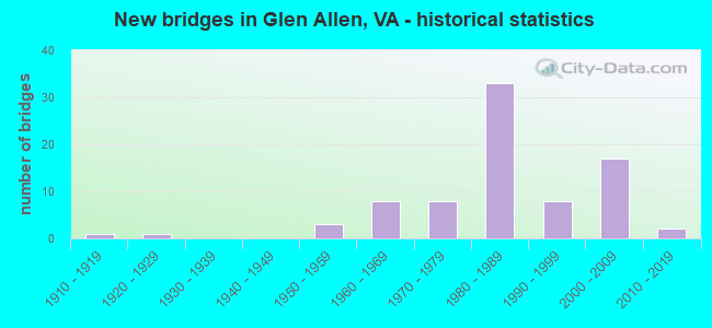
- New bridges - historical statistics
- 11910-1919
- 11920-1929
- 31950-1959
- 81960-1969
- 81970-1979
- 331980-1989
- 81990-1999
- 172000-2009
- 22010-2019
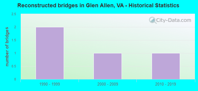
- Reconstructed bridges - Historical Statistics
- 21990-1999
- 12000-2009
- 12010-2019
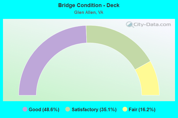
- Bridge Condition - Deck
- 48.6%Good
- 35.1%Satisfactory
- 16.2%Fair
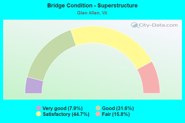
- Bridge Condition - Superstructure
- 7.9%Very good
- 31.6%Good
- 44.7%Satisfactory
- 15.8%Fair
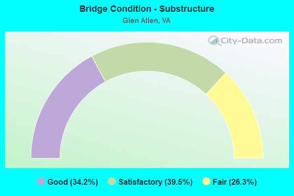
- Bridge Condition - Substructure
- 34.2%Good
- 39.5%Satisfactory
- 26.3%Fair
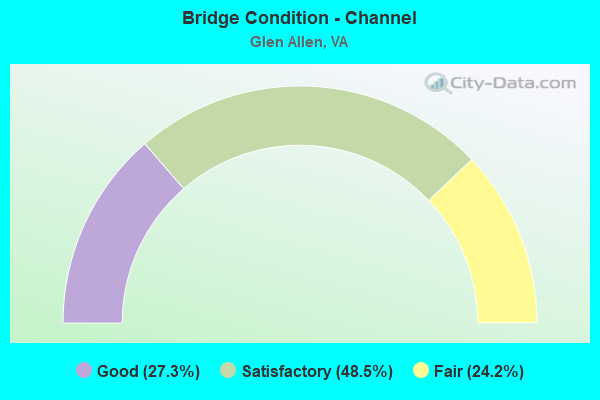
- Bridge Condition - Channel
- 27.3%Good
- 48.5%Satisfactory
- 24.2%Fair
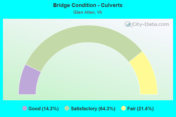
- Bridge Condition - Culverts
- 14.3%Good
- 64.3%Satisfactory
- 21.4%Fair
Find on map >> Show street view
Structure Number: 3602, Location: 1.11 FR 623 & .47 TO 644 (Lat: 36.723911, Lng: -77.934447), Route carried "on" structure: US 58, Year Built: 1966, Status: Open, Structure Length: 10.12m (33.20ft), Average Daily Traffic: 3,967 (year 2020), Truck Traffic: 19%, Average Future Daily Traffic: 5,555 (year 2040), Design Load: HS 20+Mod, Features Intersected: MEHERRIN RIVER, Facility Carried by Structure: GOV.HARRISON PKWY
Minimum Vertical Clearance: 30+ m (98+ ft), Kilometerpoint: 619.188, Lanes on structure: 2, Base Highway Network: Yes, Owner: State Highway Agency, Approaching Roadway Width: 10.4m (34.1ft), Skew: 2 degrees, Material/Design: Steel, Design/Construction: Stringer/Multi-beam, Number Of Spans In Main Unit: 3, Length of Maximum Span: 33.5m (109.9ft), Curb or Sidewalk Widths: Left: 0.2m (0.7ft), Right: 0.2m (0.7ft), Curb-To-Curb Width: 10.0m (32.8ft), Out-to-Out Width: 10.9m (35.8ft)
Condition: Deck: Fair, Superstructure: Fair, Substructure: Satisfactory, Channel: Satisfactory, Operating Rating: 65.3 metric tons, Method Used To Determine Operating Rating: Load and Resistance Factor (LRFR), Inventory Rating: 49.9 metric tons, Method Used To Determine Inventory Rating: Load and Resistance Factor (LRFR), Structural Evaluation: Somewhat better than minimum adequacy, Deck Geometry: Meets minimum limits, Waterway Adequacy: Equal to present minimum criteria, Approach Roadway Alignment: Equal to present desirable criteria, Length Of Structure Improvement: 12.65m (41.50ft), Designated Inspection Frequency: Every 24 months, Underwater Inspection Frequency: Every 60 months, Inspection Date: June 2021, Underwater Inspection Date: May 2021, Bridge Improvement Cost: $498,000, Roadway Improvement Cost: $200,000, Total Project Cost: $700,000, Deck Structure Type: Concrete Cast-file-Place
Find on map >> Show street view
Structure Number: 9364, Location: 0.36 fr 661 & 0.06 to 719 (Lat: 37.695772, Lng: -77.463333), Route carried "on" structure: US 1, Year Built: 1923, Year Reconstructed: 2006, Status: Open, Structure Length: 0.99m (3.25ft), Average Daily Traffic: 13,221 (year 2020), Truck Traffic: 2%, Average Future Daily Traffic: 13,863 (year 2040), Design Load: H 15, Features Intersected: STONEY RUN, Facility Carried by Structure: WASHINGTON HIGHWAY
Minimum Vertical Clearance: 30+ m (98+ ft), Kilometerpoint: 167.632, Lanes on structure: 4, Owner: State Highway Agency, Approaching Roadway Width: 13.1m (43.0ft), Material/Design: Concrete, Design/Construction: Tee Beam, Number Of Spans In Main Unit: 1, Length of Maximum Span: 9.6m (31.5ft), Curb-To-Curb Width: 13.4m (44.0ft), Out-to-Out Width: 14.2m (46.6ft)
Condition: Deck: Satisfactory, Superstructure: Fair, Substructure: Fair, Channel: Satisfactory, Operating Rating: 42.6 metric tons, Method Used To Determine Operating Rating: Load and Resistance Factor (LRFR), Inventory Rating: 32.9 metric tons, Method Used To Determine Inventory Rating: Load and Resistance Factor (LRFR), Structural Evaluation: Somewhat better than minimum adequacy, Deck Geometry: High priority of replacement, Waterway Adequacy: Better than present minimum criteria, Approach Roadway Alignment: Equal to present desirable criteria, Length Of Structure Improvement: 0.03m (0.10ft), Designated Inspection Frequency: Every 24 months, Inspection Date: April 2021, Bridge Improvement Cost: $20,000, Roadway Improvement Cost: $2,000, Total Project Cost: $27,000, Deck Structure Type: Concrete Cast-file-Place, Wearing Surface/Protective System: Wearing Surface: Bituminous
Find on map >> Show street view
Structure Number: 9398, Location: 0.99 Fr 835 & 1.65 To 802 (Lat: 37.698472, Lng: -77.449300), Route carried "on" structure: Interstate 95, Year Built: 1959, Status: Open, Structure Length: 0.72m (2.36ft), Average Daily Traffic: 53,485 (year 2020), Truck Traffic: 12%, Average Future Daily Traffic: 74,879 (year 2040), Design Load: HS 20, Features Intersected: LICKINGHOLE CREEK
Minimum Vertical Clearance: 30+ m (98+ ft), Kilometerpoint: 141.238, Lanes on structure: 3, Base Highway Network: Yes, Owner: State Highway Agency, Approaching Roadway Width: 16.8m (55.1ft), Skew: 4 degrees, Material/Design: Concrete, Design/Construction: Culvert, Number Of Spans In Main Unit: 2, Length of Maximum Span: 3.4m (11.2ft)
Condition: Channel: Satisfactory, Culverts: Satisfactory, Operating Rating: 54.4 metric tons, Method Used To Determine Operating Rating: Field evaluation and documented engineering judgment, Inventory Rating: 32.7 metric tons, Method Used To Determine Inventory Rating: Field evaluation and documented engineering judgment, Structural Evaluation: Equal to present minimum criteria, Waterway Adequacy: Better than present minimum criteria, Approach Roadway Alignment: Equal to present desirable criteria, Designated Inspection Frequency: Every 24 months, Inspection Date: January 2021
Find on map >> Show street view
Structure Number: 9399, Location: 0.97 Fr 835 & 1.67 To 802 (Lat: 37.697319, Lng: -77.448608), Route carried "on" structure: Interstate 95, Year Built: 1959, Year Reconstructed: 2003, Status: Open, Structure Length: 0.72m (2.36ft), Average Daily Traffic: 71,407 (year 2020), Truck Traffic: 12%, Average Future Daily Traffic: 99,970 (year 2040), Design Load: HS 20, Features Intersected: LICKINGHOLE CREEK
Minimum Vertical Clearance: 30+ m (98+ ft), Kilometerpoint: 141.206, Lanes on structure: 4, Base Highway Network: Yes, Owner: State Highway Agency, Approaching Roadway Width: 20.7m (67.9ft), Skew: 4 degrees, Material/Design: Concrete, Design/Construction: Culvert, Number Of Spans In Main Unit: 2, Length of Maximum Span: 3.4m (11.2ft)
Condition: Channel: Satisfactory, Culverts: Satisfactory, Operating Rating: 89.8 metric tons, Method Used To Determine Operating Rating: Field evaluation and documented engineering judgment, Inventory Rating: 89.8 metric tons, Method Used To Determine Inventory Rating: Field evaluation and documented engineering judgment, Structural Evaluation: Equal to present minimum criteria, Waterway Adequacy: Better than present minimum criteria, Approach Roadway Alignment: Equal to present desirable criteria, Designated Inspection Frequency: Every 24 months, Inspection Date: January 2021
Find on map >> Show street view
Structure Number: 94, Location: 0.18 Fr 835 & 2.46 To 802 (Lat: 37.686394, Lng: -77.451975), Route carried "on" structure: Interstate 95, Year Built: 1959, Status: Open, Structure Length: 0.78m (2.56ft), Average Daily Traffic: 115,136 (year 2020), Truck Traffic: 13%, Average Future Daily Traffic: 161,190 (year 2040), Design Load: HS 20, Features Intersected: STONY RUN
Minimum Vertical Clearance: 30+ m (98+ ft), Kilometerpoint: 139.919, Lanes on structure: 7, Base Highway Network: Yes, Owner: State Highway Agency, Approaching Roadway Width: 31.7m (104.0ft), Skew: 20 degrees, Material/Design: Concrete, Design/Construction: Culvert, Number Of Spans In Main Unit: 3, Length of Maximum Span: 2.4m (7.9ft)
Condition: Channel: Satisfactory, Culverts: Satisfactory, Operating Rating: 54.4 metric tons, Method Used To Determine Operating Rating: Field evaluation and documented engineering judgment, Inventory Rating: 32.7 metric tons, Method Used To Determine Inventory Rating: Field evaluation and documented engineering judgment, Structural Evaluation: Equal to present minimum criteria, Waterway Adequacy: Equal to present desirable criteria, Approach Roadway Alignment: Equal to present desirable criteria, Designated Inspection Frequency: Every 24 months, Inspection Date: January 2021
Find on map >> Show street view
Structure Number: 9502, Location: 0.0 TO HENRICO CO LINE (Lat: 37.694097, Lng: -77.491453), Route carried "on" structure: County highway 626, Year Built: 1983, Status: Open, Structure Length: 4.19m (13.75ft), Average Daily Traffic: 2,577 (year 2020), Truck Traffic: 1%, Average Future Daily Traffic: 3,608 (year 2040), Design Load: HS 20+Mod, Features Intersected: CHICKAHOMINY RIVER, Facility Carried by Structure: OLD WASHINGTON HWY
Minimum Vertical Clearance: 30+ m (98+ ft), Kilometerpoint: 0.016, Lanes on structure: 2, Owner: State Highway Agency, Approaching Roadway Width: 9.1m (29.9ft), Material/Design: Steel, Design/Construction: Stringer/Multi-beam, Number Of Spans In Main Unit: 3, Length of Maximum Span: 16.4m (53.8ft), Curb-To-Curb Width: 8.7m (28.5ft), Out-to-Out Width: 9.7m (31.8ft)
Condition: Deck: Fair, Superstructure: Fair, Substructure: Satisfactory, Channel: Fair, Operating Rating: 72.6 metric tons, Method Used To Determine Operating Rating: Load and Resistance Factor (LRFR), Inventory Rating: 56.2 metric tons, Method Used To Determine Inventory Rating: Load and Resistance Factor (LRFR), Structural Evaluation: Somewhat better than minimum adequacy, Deck Geometry: Meets minimum limits, Waterway Adequacy: Equal to present desirable criteria, Approach Roadway Alignment: Equal to present desirable criteria, Designated Inspection Frequency: Every 24 months, Inspection Date: Febuary 2022, Deck Structure Type: Concrete Cast-file-Place, Wearing Surface/Protective System: Deck Protection: Epoxy Coated Reinforcing
Find on map >> Show street view
Structure Number: 9532, Location: 0.10 FR 95 & 0.78 TO 637 (Lat: 37.684719, Lng: -77.449150), Route carried "on" structure: County highway 835, Year Built: 1960, Status: Open, Structure Length: 1.22m (4.00ft), Average Daily Traffic: 5,216 (year 2020), Truck Traffic: 2%, Average Future Daily Traffic: 5,738 (year 2040), Design Load: HS 20, Features Intersected: STONY RUN CREEK, Facility Carried by Structure: King's Charter Dr.
Minimum Vertical Clearance: 30+ m (98+ ft), Kilometerpoint: 1.014, Lanes on structure: 2, Owner: State Highway Agency, Approaching Roadway Width: 12.2m (40.0ft), Skew: 1 degrees, Material/Design: Concrete, Design/Construction: Culvert, Number Of Spans In Main Unit: 4, Length of Maximum Span: 2.4m (7.9ft)
Condition: Channel: Fair, Culverts: Satisfactory, Operating Rating: 54.4 metric tons, Method Used To Determine Operating Rating: Field evaluation and documented engineering judgment, Inventory Rating: 32.7 metric tons, Method Used To Determine Inventory Rating: Field evaluation and documented engineering judgment, Structural Evaluation: Equal to present minimum criteria, Waterway Adequacy: Equal to present desirable criteria, Approach Roadway Alignment: Equal to present desirable criteria, Designated Inspection Frequency: Every 24 months, Inspection Date: December 2020
Find on map >> Show street view
Structure Number: 954, Location: 1.10 TO 33 & 0.60 TO 625 (Lat: 37.705106, Lng: -77.537306), Route carried "on" structure: County highway 660, Year Built: 1970, Year Reconstructed: 2015, Status: Open, Structure Length: 0.77m (2.53ft), Average Daily Traffic: 907 (year 2020), Truck Traffic: 1%, Average Future Daily Traffic: 1,136 (year 2040), Design Load: HS 20+Mod, Features Intersected: GRASSY SWAMP CREEK, Facility Carried by Structure: WINNS CHURCH ROAD
Minimum Vertical Clearance: 30+ m (98+ ft), Kilometerpoint: 1.765, Lanes on structure: 2, Owner: State Highway Agency, Approaching Roadway Width: 7.0m (23.0ft), Material/Design: Steel, Design/Construction: Culvert, Number Of Spans In Main Unit: 1, Number Of Approach Spans: 2, Length of Maximum Span: 1.9m (6.2ft)
Condition: Channel: Fair, Culverts: Fair, Operating Rating: 44.5 metric tons, Method Used To Determine Operating Rating: Field evaluation and documented engineering judgment, Inventory Rating: 32.7 metric tons, Method Used To Determine Inventory Rating: Field evaluation and documented engineering judgment, Structural Evaluation: Somewhat better than minimum adequacy, Waterway Adequacy: Equal to present desirable criteria, Approach Roadway Alignment: Equal to present desirable criteria, Designated Inspection Frequency: Every 24 months, Inspection Date: June 2021
Find on map >> Show street view
Structure Number: 9541, Location: 0.20 fr DEAD END (Lat: 37.692936, Lng: -77.459869), Route carried "on" structure: County highway 661, Year Built: 1919, Status: Posted for load, Structure Length: 1.34m (4.40ft), Average Daily Traffic: 127 (year 2020), Average Future Daily Traffic: 178 (year 2040), Design Load: H 10, Features Intersected: STONY RUN, Facility Carried by Structure: OLD TELEGRAPH ROAD
Minimum Vertical Clearance: 30+ m (98+ ft), Kilometerpoint: 0.550, Lanes on structure: 1, Owner: State Highway Agency, Approaching Roadway Width: 4.9m (16.1ft), Material/Design: Concrete, Design/Construction: Slab, Number Of Spans In Main Unit: 2, Length of Maximum Span: 6.7m (22.0ft), Curb-To-Curb Width: 3.6m (11.8ft), Out-to-Out Width: 4.8m (15.7ft)
Condition: Deck: Satisfactory, Superstructure: Satisfactory, Substructure: Fair, Channel: Fair, Operating Rating: 40.9 metric tons, Method Used To Determine Operating Rating: Load Factor (LF), Inventory Rating: 24.5 metric tons, Method Used To Determine Inventory Rating: Load Factor (LF), Structural Evaluation: Somewhat better than minimum adequacy, Deck Geometry: High priority of replacement, Waterway Adequacy: Equal to present minimum criteria, Approach Roadway Alignment: Better than present minimum criteria, Length Of Structure Improvement: 2.29m (7.51ft), Designated Inspection Frequency: Every 24 months, Inspection Date: June 2021, Bridge Improvement Cost: $244,000, Roadway Improvement Cost: $130,000, Total Project Cost: $430,000, Deck Structure Type: Concrete Cast-file-Place, Wearing Surface/Protective System: Wearing Surface: Bituminous
Find on map >> Show street view
Structure Number: 9622, Location: 0.04TELEGR RD0.17F-110 (Lat: 37.663711, Lng: -77.449519), Route carried "on" structure: County highway , Year Built: 1980, Status: Open, Structure Length: 22.46m (73.69ft), Average Daily Traffic: 3,605 (year 2020), Average Future Daily Traffic: 3,966 (year 2040), Design Load: HS 20+Mod, Features Intersected: I-95 & I-95 CONN, Facility Carried by Structure: VA CENTER PARKWAY
Minimum Vertical Clearance: 30+ m (98+ ft), Kilometerpoint: 0.000, Lanes on structure: 4, Lanes under structure: 11, Owner: State Highway Agency, Approaching Roadway Width: 21.0m (68.9ft), Skew: 21 degrees, Material/Design: Steel continuous, Design/Construction: Stringer/Multi-beam, Number Of Spans In Main Unit: 4, Number Of Approach Spans: 2, Length of Maximum Span: 45.7m (149.9ft), Curb-To-Curb Width: 24.9m (81.7ft), Out-to-Out Width: 26.2m (86.0ft)
Condition: Deck: Satisfactory, Superstructure: Satisfactory, Substructure: Fair, Operating Rating: 36.3 metric tons, Method Used To Determine Operating Rating: Load and Resistance Factor (LRFR), Inventory Rating: 28.1 metric tons, Method Used To Determine Inventory Rating: Load and Resistance Factor (LRFR), Structural Evaluation: Somewhat better than minimum adequacy, Deck Geometry: Superior to present desirable criteria, Underclear: Equal to present minimum criteria, Approach Roadway Alignment: Meets minimum limits, Designated Inspection Frequency: Every 24 months, Inspection Date: March 2021, Deck Structure Type: Concrete Cast-file-Place, Wearing Surface/Protective System: Deck Protection: Epoxy Coated Reinforcing
Find on map >> Show street view
Structure Number: 963, Location: 0.40 FR 1 & 1.30 MAG PKWY (Lat: 37.640142, Lng: -77.452831), Route carried "on" structure: County highway , Year Built: 1962, Status: Posted for load, Structure Length: 8.08m (26.51ft), Average Daily Traffic: 550 (year 1987), Truck Traffic: 2%, Average Future Daily Traffic: 770 (year 2025), Design Load: H 20, Features Intersected: I 95, Facility Carried by Structure: SCOTT ROAD
Minimum Vertical Clearance: 30+ m (98+ ft), Kilometerpoint: 0.000, Lanes on structure: 2, Lanes under structure: 8, Owner: State Highway Agency, Approaching Roadway Width: 7.6m (24.9ft), Skew: 2 degrees, Material/Design: Steel, Design/Construction: Stringer/Multi-beam, Number Of Spans In Main Unit: 4, Length of Maximum Span: 24.8m (81.4ft), Curb or Sidewalk Widths: Left: 0.5m (1.6ft), Right: 0.5m (1.6ft), Curb-To-Curb Width: 7.3m (24.0ft), Out-to-Out Width: 8.2m (26.9ft)
Condition: Deck: Fair, Superstructure: Fair, Substructure: Fair, Operating Rating: 26.2 metric tons, Method Used To Determine Operating Rating: Load and Resistance Factor (LRFR), Inventory Rating: 20.2 metric tons, Method Used To Determine Inventory Rating: Load and Resistance Factor (LRFR), Structural Evaluation: Somewhat better than minimum adequacy, Deck Geometry: Meets minimum limits, Underclear: High priority of corrective action, Approach Roadway Alignment: Equal to present minimum criteria, Length Of Structure Improvement: 8.08m (26.51ft), Designated Inspection Frequency: Every 12 months, Inspection Date: April 2021, Bridge Improvement Cost: $100,000, Roadway Improvement Cost: $10,000, Total Project Cost: $120,000, Deck Structure Type: Concrete Cast-file-Place
Find on map >> Show street view
Structure Number: 9682, Location: .55 MTN RD/1.13 OLD WASH (Lat: 37.681183, Lng: -77.522581), Route carried "on" structure: County highway , Year Built: 1980, Status: Open, Structure Length: 12.64m (41.47ft), Average Daily Traffic: 2,285 (year 2020), Truck Traffic: 2%, Average Future Daily Traffic: 3,199 (year 2040), Design Load: HS 20+Mod, Features Intersected: I-295, Facility Carried by Structure: MILL ROAD
Minimum Vertical Clearance: 30+ m (98+ ft), Kilometerpoint: 0.644, Lanes on structure: 4, Lanes under structure: 6, Owner: State Highway Agency, Approaching Roadway Width: 19.5m (64.0ft), Skew: 22 degrees, Material/Design: Steel continuous, Design/Construction: Stringer/Multi-beam, Number Of Spans In Main Unit: 3, Number Of Approach Spans: 2, Length of Maximum Span: 33.5m (109.9ft), Curb-To-Curb Width: 25.5m (83.7ft), Out-to-Out Width: 26.8m (87.9ft)
Condition: Deck: Good, Superstructure: Satisfactory, Substructure: Fair, Operating Rating: 56.9 metric tons, Method Used To Determine Operating Rating: Load and Resistance Factor (LRFR), Inventory Rating: 43.8 metric tons, Method Used To Determine Inventory Rating: Load and Resistance Factor (LRFR), Structural Evaluation: Somewhat better than minimum adequacy, Deck Geometry: Superior to present desirable criteria, Underclear: Somewhat better than minimum adequacy, Approach Roadway Alignment: Equal to present desirable criteria, Designated Inspection Frequency: Every 24 months, Inspection Date: September 2021, Deck Structure Type: Concrete Cast-file-Place, Wearing Surface/Protective System: Deck Protection: Epoxy Coated Reinforcing
Find on map >> Show street view
Structure Number: 9688, Location: .25frMNT & .35 to 625 (Lat: 37.666728, Lng: -77.484847), Route carried "on" structure: County highway 7663, Year Built: 1980, Status: Open, Structure Length: 11.30m (37.07ft), Average Daily Traffic: 7,177 (year 2020), Truck Traffic: 2%, Average Future Daily Traffic: 9,234 (year 2040), Design Load: HS 20+Mod, Features Intersected: ROUTE I-295, Facility Carried by Structure: WOODMAN ROAD
Minimum Vertical Clearance: 30.18m (99.02ft), Kilometerpoint: 7.916, Lanes on structure: 6, Lanes under structure: 8, Owner: State Highway Agency, Approaching Roadway Width: 26.8m (87.9ft), Skew: 21 degrees, Material/Design: Steel continuous, Design/Construction: Stringer/Multi-beam, Number Of Spans In Main Unit: 3, Length of Maximum Span: 39.4m (129.3ft), Curb-To-Curb Width: 31.0m (101.7ft), Out-to-Out Width: 32.3m (106.0ft)
Condition: Deck: Satisfactory, Superstructure: Satisfactory, Substructure: Satisfactory, Operating Rating: 57.2 metric tons, Method Used To Determine Operating Rating: Load and Resistance Factor (LRFR), Inventory Rating: 43.5 metric tons, Method Used To Determine Inventory Rating: Load and Resistance Factor (LRFR), Structural Evaluation: Equal to present minimum criteria, Deck Geometry: Superior to present desirable criteria, Underclear: Somewhat better than minimum adequacy, Approach Roadway Alignment: Equal to present desirable criteria, Designated Inspection Frequency: Every 24 months, Inspection Date: June 2021, Deck Structure Type: Concrete Cast-file-Place, Wearing Surface/Protective System: Deck Protection: Epoxy Coated Reinforcing
Find on map >> Show street view
Structure Number: 9698, Location: 0.62 TO WOODMAN ROAD (Lat: 37.665000, Lng: -77.497500), Route carried "on" structure: County highway , Year Built: 1987, Status: Open, Structure Length: 1.80m (5.91ft), Average Daily Traffic: 7,751 (year 2020), Truck Traffic: 2%, Average Future Daily Traffic: 10,033 (year 2040), Design Load: HS 20+Mod, Features Intersected: NORTH RUN CREEK, Facility Carried by Structure: MOUNTAIN ROAD
Minimum Vertical Clearance: 30+ m (98+ ft), Kilometerpoint: 4.088, Lanes on structure: 2, Owner: County Highway Agency, Approaching Roadway Width: 7.3m (24.0ft), Skew: 4 degrees, Material/Design: Concrete, Design/Construction: Culvert, Number Of Spans In Main Unit: 4, Length of Maximum Span: 4.3m (14.1ft)
Condition: Channel: Good, Culverts: Good, Operating Rating: 54.4 metric tons, Method Used To Determine Operating Rating: Load Factor (LF), Inventory Rating: 32.7 metric tons, Method Used To Determine Inventory Rating: Load Factor (LF), Structural Evaluation: Better than present minimum criteria, Waterway Adequacy: Equal to present desirable criteria, Approach Roadway Alignment: Equal to present desirable criteria, Designated Inspection Frequency: Every 24 months, Inspection Date: January 2022
Find on map >> Show street view
Structure Number: 9828, Location: 0.44 RTE 1 & 1.9 RTE 301 (Lat: 37.636089, Lng: -77.452097), Route carried "on" structure: State highway 73, Year Built: 1978, Status: Open, Structure Length: 6.23m (20.44ft), Average Daily Traffic: 14,380 (year 2020), Truck Traffic: 1%, Average Future Daily Traffic: 20,133 (year 2040), Design Load: HS 20+Mod, Features Intersected: ROUTE I-95, Facility Carried by Structure: WBL PARHAM ROAD
Minimum Vertical Clearance: 30+ m (98+ ft), Kilometerpoint: 0.647, Lanes on structure: 3, Lanes under structure: 8, Base Highway Network: Yes, Owner: State Highway Agency, Approaching Roadway Width: 16.2m (53.1ft), Material/Design: Steel continuous, Design/Construction: Stringer/Multi-beam, Number Of Spans In Main Unit: 2, Length of Maximum Span: 30.7m (100.7ft), Curb-To-Curb Width: 15.2m (49.9ft), Out-to-Out Width: 16.4m (53.8ft)
Condition: Deck: Satisfactory, Superstructure: Fair, Substructure: Fair, Operating Rating: 77.7 metric tons, Method Used To Determine Operating Rating: Load and Resistance Factor (LRFR), Inventory Rating: 59.9 metric tons, Method Used To Determine Inventory Rating: Load and Resistance Factor (LRFR), Structural Evaluation: Somewhat better than minimum adequacy, Deck Geometry: Equal to present minimum criteria, Underclear: High priority of corrective action, Approach Roadway Alignment: Equal to present desirable criteria, Length Of Structure Improvement: 6.22m (20.41ft), Designated Inspection Frequency: Every 24 months, Inspection Date: January 2021, Bridge Improvement Cost: $275,000, Roadway Improvement Cost: $90,000, Total Project Cost: $438,000, Deck Structure Type: Concrete Cast-file-Place, Wearing Surface/Protective System: Deck Protection: Epoxy Coated Reinforcing
Find on map >> Show street view
Structure Number: 983, Location: .44 FR RT 1/.84 TO RT 301 (Lat: 37.635725, Lng: -77.452011), Route carried "on" structure: State highway 73, Year Built: 1962, Status: Open, Structure Length: 6.87m (22.54ft), Average Daily Traffic: 14,380 (year 2020), Truck Traffic: 1%, Average Future Daily Traffic: 20,133 (year 2040), Design Load: HS 20+Mod, Features Intersected: ROUTE I-95, Facility Carried by Structure: EBL PARHAM ROAD
Minimum Vertical Clearance: 30+ m (98+ ft), Kilometerpoint: 0.640, Lanes on structure: 3, Lanes under structure: 8, Base Highway Network: Yes, Owner: State Highway Agency, Approaching Roadway Width: 13.1m (43.0ft), Material/Design: Steel, Design/Construction: Stringer/Multi-beam, Number Of Spans In Main Unit: 4, Length of Maximum Span: 25.3m (83.0ft), Curb-To-Curb Width: 11.9m (39.0ft), Out-to-Out Width: 13.1m (43.0ft)
Condition: Deck: Fair, Superstructure: Fair, Substructure: Fair, Operating Rating: 59.6 metric tons, Method Used To Determine Operating Rating: Load and Resistance Factor (LRFR), Inventory Rating: 46.0 metric tons, Method Used To Determine Inventory Rating: Load and Resistance Factor (LRFR), Structural Evaluation: Somewhat better than minimum adequacy, Deck Geometry: High priority of corrective action, Underclear: High priority of corrective action, Approach Roadway Alignment: Equal to present desirable criteria, Length Of Structure Improvement: 6.86m (22.51ft), Designated Inspection Frequency: Every 24 months, Inspection Date: January 2021, Bridge Improvement Cost: $275,000, Roadway Improvement Cost: $90,000, Total Project Cost: $438,000, Deck Structure Type: Concrete Cast-file-Place, Wearing Surface/Protective System: Wearing Surface: Latex Concrete
Find on map >> Show street view
Structure Number: 9839, Location: Henrico Hanover Cty Line (Lat: 37.680036, Lng: -77.450792), Route carried "on" structure: Interstate 95, Year Built: 1961, Year Reconstructed: 2004, Status: Open, Structure Length: 6.19m (20.31ft), Average Daily Traffic: 115,136 (year 2020), Truck Traffic: 13%, Average Future Daily Traffic: 161,190 (year 2040), Design Load: HS 20+Mod, Features Intersected: CHICKAHOMINY RIVER
Minimum Vertical Clearance: 30+ m (98+ ft), Kilometerpoint: 139.211, Lanes on structure: 11, Base Highway Network: Yes, Owner: State Highway Agency, Approaching Roadway Width: 60.7m (199.1ft), Skew: 33 degrees, Material/Design: Steel, Design/Construction: Stringer/Multi-beam, Number Of Spans In Main Unit: 3, Length of Maximum Span: 19.9m (65.3ft), Curb-To-Curb Width: 60.8m (199.5ft), Out-to-Out Width: 62.6m (205.4ft)
Condition: Deck: Satisfactory, Superstructure: Satisfactory, Substructure: Good, Channel: Fair, Operating Rating: 80.0 metric tons, Method Used To Determine Operating Rating: Load and Resistance Factor (LRFR), Inventory Rating: 61.7 metric tons, Method Used To Determine Inventory Rating: Load and Resistance Factor (LRFR), Structural Evaluation: Equal to present minimum criteria, Deck Geometry: Superior to present desirable criteria, Waterway Adequacy: Better than present minimum criteria, Approach Roadway Alignment: Equal to present desirable criteria, Designated Inspection Frequency: Every 24 months, Inspection Date: August 2020, Deck Structure Type: Concrete Cast-file-Place, Wearing Surface/Protective System: Deck Protection: Epoxy Coated Reinforcing
Find on map >> Show street view
Structure Number: 984, Location: 1.4 TO 295W & .3 HANOVER (Lat: 37.677453, Lng: -77.449694), Route carried "on" structure: Interstate 95, Year Built: 1962, Status: Open, Structure Length: 0.73m (2.40ft), Average Daily Traffic: 115,136 (year 2020), Truck Traffic: 12%, Average Future Daily Traffic: 161,190 (year 2040), Design Load: HS 20, Features Intersected: BRANCH
Minimum Vertical Clearance: 30+ m (98+ ft), Kilometerpoint: 138.857, Lanes on structure: 7, Base Highway Network: Yes, Owner: State Highway Agency, Approaching Roadway Width: 33.8m (110.9ft), Skew: 21 degrees, Material/Design: Concrete, Design/Construction: Culvert, Number Of Spans In Main Unit: 3, Length of Maximum Span: 2.2m (7.2ft)
Condition: Channel: Fair, Culverts: Satisfactory, Operating Rating: 54.4 metric tons, Method Used To Determine Operating Rating: Field evaluation and documented engineering judgment, Inventory Rating: 32.7 metric tons, Method Used To Determine Inventory Rating: Field evaluation and documented engineering judgment, Structural Evaluation: Equal to present minimum criteria, Waterway Adequacy: Better than present minimum criteria, Approach Roadway Alignment: Equal to present desirable criteria, Designated Inspection Frequency: Every 24 months, Inspection Date: December 2020
Find on map >> Show street view
Structure Number: 9846, Location: 0.36I-295 & 1.31HANOV CO (Lat: 37.662886, Lng: -77.448431), Route carried "on" structure: Interstate 95, Year Built: 1980, Status: Open, Structure Length: 18.65m (61.19ft), Average Daily Traffic: 52,116 (year 2020), Truck Traffic: 13%, Average Future Daily Traffic: 72,962 (year 2040), Design Load: HS 20+Mod, Features Intersected: ROUTE 0095 CONNECTIONS
Minimum Vertical Clearance: 6.04m (19.82ft), Kilometerpoint: 136.845, Lanes on structure: 3, Lanes under structure: 7, Base Highway Network: Yes, Owner: State Highway Agency, Approaching Roadway Width: 18.6m (61.0ft), Skew: 5 degrees, Material/Design: Steel continuous, Design/Construction: Stringer/Multi-beam, Number Of Spans In Main Unit: 2, Number Of Approach Spans: 2, Length of Maximum Span: 68.3m (224.1ft), Curb-To-Curb Width: 17.9m (58.7ft), Out-to-Out Width: 18.9m (62.0ft)
Condition: Deck: Satisfactory, Superstructure: Good, Substructure: Fair, Operating Rating: 89.8 metric tons, Method Used To Determine Operating Rating: Load and Resistance Factor (LRFR), Inventory Rating: 76.2 metric tons, Method Used To Determine Inventory Rating: Load and Resistance Factor (LRFR), Structural Evaluation: Somewhat better than minimum adequacy, Deck Geometry: Better than present minimum criteria, Underclear: Superior to present desirable criteria, Approach Roadway Alignment: Equal to present desirable criteria, Designated Inspection Frequency: Every 24 months, Inspection Date: Febuary 2021, Deck Structure Type: Concrete Cast-file-Place, Wearing Surface/Protective System: Deck Protection: Epoxy Coated Reinforcing
Find on map >> Show street view
Structure Number: 9848, Location: 0.70I-95 SBL 0.70I-295 EB (Lat: 37.657594, Lng: -77.445578), Route carried "on" structure: Ramp Interstate 95, Year Built: 1980, Status: Open, Structure Length: 7.80m (25.59ft), Average Daily Traffic: 20,466 (year 2020), Truck Traffic: 4%, Average Future Daily Traffic: 28,652 (year 2040), Design Load: HS 20+Mod, Features Intersected: WBL ROUTE 0295
Minimum Vertical Clearance: 30+ m (98+ ft), Kilometerpoint: 1.126, Lanes on structure: 3, Lanes under structure: 3, Base Highway Network: Yes, Owner: State Highway Agency, Approaching Roadway Width: 18.0m (59.1ft), Skew: 4 degrees, Material/Design: Steel continuous, Design/Construction: Stringer/Multi-beam, Number Of Spans In Main Unit: 3, Length of Maximum Span: 37.5m (123.0ft), Curb-To-Curb Width: 17.6m (57.7ft), Out-to-Out Width: 18.8m (61.7ft)
Condition: Deck: Good, Superstructure: Satisfactory, Substructure: Satisfactory, Operating Rating: 88.5 metric tons, Method Used To Determine Operating Rating: Load and Resistance Factor (LRFR), Inventory Rating: 69.2 metric tons, Method Used To Determine Inventory Rating: Load and Resistance Factor (LRFR), Structural Evaluation: Equal to present minimum criteria, Deck Geometry: Superior to present desirable criteria, Approach Roadway Alignment: Equal to present desirable criteria, Designated Inspection Frequency: Every 24 months, Inspection Date: November 2020, Deck Structure Type: Concrete Cast-file-Place, Wearing Surface/Protective System: Deck Protection: Epoxy Coated Reinforcing
Find on map >> Show street view
Structure Number: 985, Location: 0.60I-295 WBL0.80I-95 NBL (Lat: 37.656897, Lng: -77.443803), Route carried "on" structure: Ramp Interstate 95, Year Built: 1980, Status: Open, Structure Length: 8.42m (27.62ft), Average Daily Traffic: 20,455 (year 2020), Average Future Daily Traffic: 28,637 (year 2040), Design Load: HS 20+Mod, Features Intersected: WBL ROUTE 0295
Minimum Vertical Clearance: 21.28m (69.82ft), Kilometerpoint: 1.014, Lanes on structure: 2, Lanes under structure: 3, Base Highway Network: Yes, Owner: State Highway Agency, Approaching Roadway Width: 21.9m (71.9ft), Skew: 5 degrees, Material/Design: Steel continuous, Design/Construction: Stringer/Multi-beam, Number Of Spans In Main Unit: 3, Length of Maximum Span: 41.5m (136.2ft), Curb-To-Curb Width: 21.3m (69.9ft), Out-to-Out Width: 22.5m (73.8ft)
Condition: Deck: Satisfactory, Superstructure: Satisfactory, Substructure: Satisfactory, Inventory Rating: 90.5 metric tons, Method Used To Determine Inventory Rating: Load and Resistance Factor (LRFR), Structural Evaluation: Equal to present minimum criteria, Deck Geometry: Superior to present desirable criteria, Underclear: Somewhat better than minimum adequacy, Approach Roadway Alignment: Equal to present desirable criteria, Designated Inspection Frequency: Every 24 months, Inspection Date: November 2020, Deck Structure Type: Concrete Cast-file-Place, Wearing Surface/Protective System: Deck Protection: Epoxy Coated Reinforcing
Find on map >> Show street view
Structure Number: 9852, Location: 0.6 FR I-95 & 0.8TO I-295 (Lat: 37.659100, Lng: -77.445892), Route carried "on" structure: Ramp Interstate 95, Year Built: 1979, Status: Open, Structure Length: 0.94m (3.08ft), Average Daily Traffic: 20,455 (year 2020), Average Future Daily Traffic: 28,637 (year 2040), Design Load: HS 20+Mod, Features Intersected: TURNER RUN
Minimum Vertical Clearance: 30+ m (98+ ft), Kilometerpoint: 0.000, Lanes on structure: 5, Base Highway Network: Yes, Owner: State Highway Agency, Approaching Roadway Width: 43.9m (144.0ft), Skew: 23 degrees, Material/Design: Concrete, Design/Construction: Culvert, Number Of Spans In Main Unit: 4, Length of Maximum Span: 2.1m (6.9ft)
Condition: Channel: Fair, Culverts: Satisfactory, Operating Rating: 89.8 metric tons, Method Used To Determine Operating Rating: Field evaluation and documented engineering judgment, Inventory Rating: 89.8 metric tons, Method Used To Determine Inventory Rating: Field evaluation and documented engineering judgment, Structural Evaluation: Equal to present minimum criteria, Waterway Adequacy: Equal to present desirable criteria, Approach Roadway Alignment: Equal to present desirable criteria, Designated Inspection Frequency: Every 24 months, Inspection Date: November 2020
Find on map >> Show street view
Structure Number: 9896, Location: 2.07 TO 33 & 1.23 TO WDMN (Lat: 37.676647, Lng: -77.503392), Route carried "on" structure: Interstate 295, Year Built: 1979, Status: Open, Structure Length: 10.31m (33.83ft), Average Daily Traffic: 27,534 (year 2020), Truck Traffic: 6%, Average Future Daily Traffic: 38,548 (year 2040), Design Load: HS 20+Mod, Features Intersected: OLD WASH HWY & CSX TRANS
Minimum Vertical Clearance: 30+ m (98+ ft), Kilometerpoint: 9.895, Lanes on structure: 3, Lanes under structure: 2, Base Highway Network: Yes, Owner: State Highway Agency, Approaching Roadway Width: 18.3m (60.0ft), Skew: 1 degrees, Material/Design: Steel, Design/Construction: Stringer/Multi-beam, Number Of Spans In Main Unit: 5, Length of Maximum Span: 25.4m (83.3ft), Curb-To-Curb Width: 17.8m (58.4ft), Out-to-Out Width: 18.8m (61.7ft)
Condition: Deck: Satisfactory, Superstructure: Satisfactory, Substructure: Fair, Operating Rating: 59.0 metric tons, Method Used To Determine Operating Rating: Load and Resistance Factor (LRFR), Inventory Rating: 45.4 metric tons, Method Used To Determine Inventory Rating: Load and Resistance Factor (LRFR), Structural Evaluation: Somewhat better than minimum adequacy, Deck Geometry: Better than present minimum criteria, Underclear: Equal to present minimum criteria, Approach Roadway Alignment: Equal to present desirable criteria, Designated Inspection Frequency: Every 24 months, Inspection Date: November 2021, Deck Structure Type: Concrete Cast-file-Place, Wearing Surface/Protective System: Deck Protection: Epoxy Coated Reinforcing
Find on map >> Show street view
Structure Number: 9917, Location: 0.77 TO WOODMAN ROAD (Lat: 37.660625, Lng: -77.473381), Route carried "on" structure: Interstate 295, Year Built: 1980, Status: Open, Structure Length: 4.91m (16.11ft), Average Daily Traffic: 30,682 (year 2020), Truck Traffic: 6%, Average Future Daily Traffic: 42,955 (year 2040), Design Load: HS 20+Mod, Features Intersected: GREENWOOD ROAD
Minimum Vertical Clearance: 30+ m (98+ ft), Kilometerpoint: 13.113, Lanes on structure: 3, Lanes under structure: 2, Base Highway Network: Yes, Owner: State Highway Agency, Approaching Roadway Width: 18.0m (59.1ft), Skew: 2 degrees, Material/Design: Steel, Design/Construction: Stringer/Multi-beam, Number Of Spans In Main Unit: 3, Length of Maximum Span: 28.5m (93.5ft), Curb-To-Curb Width: 17.8m (58.4ft), Out-to-Out Width: 18.8m (61.7ft)
Condition: Deck: Fair, Superstructure: Satisfactory, Substructure: Satisfactory, Operating Rating: 67.1 metric tons, Method Used To Determine Operating Rating: Load and Resistance Factor (LRFR), Inventory Rating: 51.7 metric tons, Method Used To Determine Inventory Rating: Load and Resistance Factor (LRFR), Structural Evaluation: Equal to present minimum criteria, Deck Geometry: Better than present minimum criteria, Underclear: Better than present minimum criteria, Approach Roadway Alignment: Equal to present desirable criteria, Designated Inspection Frequency: Every 24 months, Inspection Date: Febuary 2022, Deck Structure Type: Concrete Cast-file-Place, Wearing Surface/Protective System: Deck Protection: Epoxy Coated Reinforcing
Find on map >> Show street view
Structure Number: 9919, Location: 0.75 TO WOODMAN ROAD (Lat: 37.661336, Lng: -77.473575), Route carried "on" structure: Interstate 295, Year Built: 1980, Status: Open, Structure Length: 4.92m (16.14ft), Average Daily Traffic: 30,190 (year 2020), Truck Traffic: 6%, Average Future Daily Traffic: 42,266 (year 2040), Design Load: HS 20+Mod, Features Intersected: GREENWOOD ROAD
Minimum Vertical Clearance: 30+ m (98+ ft), Kilometerpoint: 13.081, Lanes on structure: 3, Lanes under structure: 2, Base Highway Network: Yes, Owner: State Highway Agency, Approaching Roadway Width: 18.0m (59.1ft), Skew: 2 degrees, Material/Design: Steel, Design/Construction: Stringer/Multi-beam, Number Of Spans In Main Unit: 3, Length of Maximum Span: 28.5m (93.5ft), Curb-To-Curb Width: 17.8m (58.4ft), Out-to-Out Width: 18.8m (61.7ft)
Condition: Deck: Fair, Superstructure: Satisfactory, Substructure: Satisfactory, Operating Rating: 65.3 metric tons, Method Used To Determine Operating Rating: Load and Resistance Factor (LRFR), Inventory Rating: 49.9 metric tons, Method Used To Determine Inventory Rating: Load and Resistance Factor (LRFR), Structural Evaluation: Equal to present minimum criteria, Deck Geometry: Better than present minimum criteria, Underclear: Better than present minimum criteria, Approach Roadway Alignment: Equal to present desirable criteria, Designated Inspection Frequency: Every 24 months, Inspection Date: Febuary 2022, Deck Structure Type: Concrete Cast-file-Place, Wearing Surface/Protective System: Deck Protection: Epoxy Coated Reinforcing
Find on map >> Show street view
Structure Number: 9921, Location: 2.32 TO NUCKOLS RD (Lat: 37.680225, Lng: -77.540619), Route carried "on" structure: Interstate 295, Year Built: 1981, Status: Open, Structure Length: 6.34m (20.80ft), Average Daily Traffic: 27,330 (year 2020), Truck Traffic: 6%, Average Future Daily Traffic: 38,262 (year 2040), Design Load: HS 20+Mod, Features Intersected: ROUTE 33
Minimum Vertical Clearance: 30+ m (98+ ft), Kilometerpoint: 6.533, Lanes on structure: 4, Lanes under structure: 6, Base Highway Network: Yes, Owner: State Highway Agency, Approaching Roadway Width: 22.3m (73.2ft), Material/Design: Steel continuous, Design/Construction: Stringer/Multi-beam, Number Of Spans In Main Unit: 2, Length of Maximum Span: 31.1m (102.0ft), Curb-To-Curb Width: 21.5m (70.5ft), Out-to-Out Width: 22.5m (73.8ft)
Condition: Deck: Satisfactory, Superstructure: Satisfactory, Substructure: Fair, Operating Rating: 78.9 metric tons, Method Used To Determine Operating Rating: Load and Resistance Factor (LRFR), Inventory Rating: 60.8 metric tons, Method Used To Determine Inventory Rating: Load and Resistance Factor (LRFR), Structural Evaluation: Somewhat better than minimum adequacy, Deck Geometry: Better than present minimum criteria, Underclear: Better than present minimum criteria, Approach Roadway Alignment: Equal to present desirable criteria, Designated Inspection Frequency: Every 24 months, Inspection Date: October 2021, Deck Structure Type: Concrete Cast-file-Place, Wearing Surface/Protective System: Deck Protection: Epoxy Coated Reinforcing
Find on map >> Show street view
Structure Number: 9923, Location: 2.32 TO 695 (Lat: 37.680972, Lng: -77.540744), Route carried "on" structure: Interstate 295, Year Built: 1981, Status: Open, Structure Length: 6.34m (20.80ft), Average Daily Traffic: 26,579 (year 2020), Truck Traffic: 7%, Average Future Daily Traffic: 37,211 (year 2040), Design Load: HS 20+Mod, Features Intersected: ROUTE 33
Minimum Vertical Clearance: 30+ m (98+ ft), Kilometerpoint: 6.533, Lanes on structure: 4, Lanes under structure: 6, Base Highway Network: Yes, Owner: State Highway Agency, Approaching Roadway Width: 22.3m (73.2ft), Material/Design: Steel continuous, Design/Construction: Stringer/Multi-beam, Number Of Spans In Main Unit: 2, Length of Maximum Span: 31.1m (102.0ft), Curb-To-Curb Width: 21.5m (70.5ft), Out-to-Out Width: 22.5m (73.8ft)
Condition: Deck: Satisfactory, Superstructure: Satisfactory, Substructure: Satisfactory, Operating Rating: 67.1 metric tons, Method Used To Determine Operating Rating: Load and Resistance Factor (LRFR), Inventory Rating: 51.7 metric tons, Method Used To Determine Inventory Rating: Load and Resistance Factor (LRFR), Structural Evaluation: Equal to present minimum criteria, Deck Geometry: Better than present minimum criteria, Underclear: Better than present minimum criteria, Approach Roadway Alignment: Equal to present desirable criteria, Designated Inspection Frequency: Every 24 months, Inspection Date: October 2021, Deck Structure Type: Concrete Cast-file-Place, Wearing Surface/Protective System: Deck Protection: Epoxy Coated Reinforcing
Find on map >> Show street view
Structure Number: 9925, Location: 0.51 FR 1 & 1.18 TO HCL (Lat: 37.657111, Lng: -77.451039), Route carried "on" structure: Interstate 295, Year Built: 1981, Status: Open, Structure Length: 7.25m (23.79ft), Average Daily Traffic: 20,000 (year 2019), Truck Traffic: 2%, Average Future Daily Traffic: 43,000 (year 2020), Design Load: HS 20+Mod, Features Intersected: I-95
Minimum Vertical Clearance: 30+ m (98+ ft), Kilometerpoint: 15.213, Lanes on structure: 2, Lanes under structure: 8, Base Highway Network: Yes, Owner: State Highway Agency, Approaching Roadway Width: 11.9m (39.0ft), Material/Design: Steel continuous, Design/Construction: Stringer/Multi-beam, Number Of Spans In Main Unit: 2, Length of Maximum Span: 35.7m (117.1ft), Curb-To-Curb Width: 11.7m (38.4ft), Out-to-Out Width: 12.7m (41.7ft)
Condition: Deck: Good, Superstructure: Satisfactory, Substructure: Satisfactory, Inventory Rating: 68.9 metric tons, Method Used To Determine Inventory Rating: Load and Resistance Factor (LRFR), Structural Evaluation: Equal to present minimum criteria, Deck Geometry: Equal to present minimum criteria, Underclear: Somewhat better than minimum adequacy, Approach Roadway Alignment: Equal to present desirable criteria, Designated Inspection Frequency: Every 24 months, Inspection Date: May 2020, Deck Structure Type: Concrete Cast-file-Place, Wearing Surface/Protective System: Wearing Surface: Latex Concrete
Find on map >> Show street view
Structure Number: 9927, Location: 0.51 TO 1 & 1.18 TO HCL (Lat: 37.658314, Lng: -77.450872), Route carried "on" structure: Interstate 295, Year Built: 1981, Status: Open, Structure Length: 7.25m (23.79ft), Average Daily Traffic: 22,000 (year 2019), Truck Traffic: 8%, Average Future Daily Traffic: 39,500 (year 2022), Design Load: HS 20+Mod, Features Intersected: ROUTE 0095
Minimum Vertical Clearance: 30+ m (98+ ft), Kilometerpoint: 15.213, Lanes on structure: 2, Lanes under structure: 8, Base Highway Network: Yes, Owner: State Highway Agency, Approaching Roadway Width: 11.9m (39.0ft), Material/Design: Steel continuous, Design/Construction: Stringer/Multi-beam, Number Of Spans In Main Unit: 2, Length of Maximum Span: 35.7m (117.1ft), Curb-To-Curb Width: 11.7m (38.4ft), Out-to-Out Width: 12.7m (41.7ft)
Condition: Deck: Good, Superstructure: Satisfactory, Substructure: Satisfactory, Operating Rating: 95.4 metric tons, Method Used To Determine Operating Rating: Load and Resistance Factor (LRFR), Inventory Rating: 70.5 metric tons, Method Used To Determine Inventory Rating: Load and Resistance Factor (LRFR), Structural Evaluation: Equal to present minimum criteria, Deck Geometry: Equal to present minimum criteria, Underclear: Equal to present minimum criteria, Approach Roadway Alignment: Equal to present desirable criteria, Designated Inspection Frequency: Every 24 months, Inspection Date: May 2020, Deck Structure Type: Concrete Cast-file-Place, Wearing Surface/Protective System: Wearing Surface: Latex Concrete
Find on map >> Show street view
Structure Number: 9929, Location: 0.51 FR 1 TO 1.18 HAN CL (Lat: 37.657442, Lng: -77.450989), Route carried "on" structure: Interstate 295, Year Built: 1981, Status: Open, Structure Length: 7.25m (23.79ft), Average Daily Traffic: 16,236 (year 2020), Truck Traffic: 5%, Average Future Daily Traffic: 22,730 (year 2040), Design Load: HS 20+Mod, Features Intersected: RTE I 95
Minimum Vertical Clearance: 30+ m (98+ ft), Kilometerpoint: 15.213, Lanes on structure: 2, Lanes under structure: 8, Base Highway Network: Yes, Owner: State Highway Agency, Approaching Roadway Width: 12.5m (41.0ft), Material/Design: Steel continuous, Design/Construction: Stringer/Multi-beam, Number Of Spans In Main Unit: 2, Length of Maximum Span: 36.3m (119.1ft), Curb-To-Curb Width: 12.3m (40.4ft), Out-to-Out Width: 13.4m (44.0ft)
Condition: Deck: Good, Superstructure: Good, Substructure: Satisfactory, Operating Rating: 70.8 metric tons, Method Used To Determine Operating Rating: Load and Resistance Factor (LRFR), Inventory Rating: 54.4 metric tons, Method Used To Determine Inventory Rating: Load and Resistance Factor (LRFR), Structural Evaluation: Equal to present minimum criteria, Deck Geometry: Better than present minimum criteria, Underclear: Somewhat better than minimum adequacy, Approach Roadway Alignment: Equal to present desirable criteria, Designated Inspection Frequency: Every 24 months, Inspection Date: May 2020, Deck Structure Type: Concrete Cast-file-Place, Wearing Surface/Protective System: Wearing Surface: Latex Concrete
Find on map >> Show street view
Structure Number: 9931, Location: 0.51 FR 1 TO 1.18 H AN CL (Lat: 37.657986, Lng: -77.450931), Route carried "on" structure: Interstate 295, Year Built: 1981, Status: Open, Structure Length: 7.25m (23.79ft), Average Daily Traffic: 16,905 (year 2020), Truck Traffic: 6%, Average Future Daily Traffic: 23,667 (year 2040), Design Load: HS 20+Mod, Features Intersected: RTE I 95
Minimum Vertical Clearance: 30+ m (98+ ft), Kilometerpoint: 15.213, Lanes on structure: 2, Lanes under structure: 8, Base Highway Network: Yes, Owner: State Highway Agency, Approaching Roadway Width: 12.5m (41.0ft), Material/Design: Steel continuous, Design/Construction: Stringer/Multi-beam, Number Of Spans In Main Unit: 2, Length of Maximum Span: 36.0m (118.1ft), Curb-To-Curb Width: 12.3m (40.4ft), Out-to-Out Width: 13.4m (44.0ft)
Condition: Deck: Good, Superstructure: Satisfactory, Substructure: Satisfactory, Operating Rating: 70.0 metric tons, Method Used To Determine Operating Rating: Load and Resistance Factor (LRFR), Inventory Rating: 54.0 metric tons, Method Used To Determine Inventory Rating: Load and Resistance Factor (LRFR), Structural Evaluation: Equal to present minimum criteria, Deck Geometry: Better than present minimum criteria, Underclear: Somewhat better than minimum adequacy, Approach Roadway Alignment: Equal to present desirable criteria, Designated Inspection Frequency: Every 24 months, Inspection Date: May 2020, Deck Structure Type: Concrete Cast-file-Place, Wearing Surface/Protective System: Wearing Surface: Latex Concrete
Find on map >> Show street view
Structure Number: 9943, Location: 0.18 FR 1 & 0.34 TO I-95 (Lat: 37.658675, Lng: -77.456603), Route carried "on" structure: Interstate 295, Year Built: 1979, Status: Open, Structure Length: 0.82m (2.69ft), Average Daily Traffic: 16,905 (year 2020), Average Future Daily Traffic: 23,667 (year 2040), Design Load: HS 20+Mod, Features Intersected: UNNAMED TRIBUTARY
Minimum Vertical Clearance: 30+ m (98+ ft), Kilometerpoint: 14.618, Lanes on structure: 4, Base Highway Network: Yes, Owner: State Highway Agency, Approaching Roadway Width: 23.2m (76.1ft), Skew: 22 degrees, Material/Design: Concrete, Design/Construction: Culvert, Number Of Spans In Main Unit: 3, Length of Maximum Span: 2.7m (8.9ft)
Condition: Channel: Fair, Culverts: Fair, Operating Rating: 89.8 metric tons, Method Used To Determine Operating Rating: Field evaluation and documented engineering judgment, Inventory Rating: 89.8 metric tons, Method Used To Determine Inventory Rating: Field evaluation and documented engineering judgment, Structural Evaluation: Somewhat better than minimum adequacy, Waterway Adequacy: Somewhat better than minimum adequacy, Approach Roadway Alignment: Equal to present desirable criteria, Designated Inspection Frequency: Every 24 months, Inspection Date: July 2020
Find on map >> Show street view
Structure Number: 23185, Location: 1.1 FR 295 & .3 TO HANOVR (Lat: 37.676525, Lng: -77.461078), Route carried "on" structure: US 1, Year Built: 1991, Status: Open, Structure Length: 1.19m (3.90ft), Average Daily Traffic: 18,282 (year 2020), Truck Traffic: 2%, Average Future Daily Traffic: 22,311 (year 2040), Design Load: HS 20+Mod, Features Intersected: UNNAMED TRIBUTARY, Facility Carried by Structure: BROOK ROAD
Minimum Vertical Clearance: 30+ m (98+ ft), Kilometerpoint: 165.449, Lanes on structure: 5, Base Highway Network: Yes, Owner: State Highway Agency, Approaching Roadway Width: 26.2m (86.0ft), Skew: 20 degrees, Material/Design: Concrete, Design/Construction: Culvert, Number Of Spans In Main Unit: 4, Length of Maximum Span: 2.7m (8.9ft)
Condition: Channel: Satisfactory, Culverts: Satisfactory, Operating Rating: 54.4 metric tons, Method Used To Determine Operating Rating: Field evaluation and documented engineering judgment, Inventory Rating: 32.7 metric tons, Method Used To Determine Inventory Rating: Field evaluation and documented engineering judgment, Structural Evaluation: Equal to present minimum criteria, Waterway Adequacy: Equal to present minimum criteria, Approach Roadway Alignment: Equal to present desirable criteria, Designated Inspection Frequency: Every 24 months, Inspection Date: March 2021
Find on map >> Show street view
Structure Number: 24622, Location: 0.21 FR 782 & 0.85 TO 637 (Lat: 37.683544, Lng: -77.452606), Route carried "on" structure: County highway 835, Year Built: 1996, Status: Open, Structure Length: 9.51m (31.20ft), Average Daily Traffic: 5,216 (year 2020), Truck Traffic: 2%, Average Future Daily Traffic: 5,738 (year 2040), Design Load: HS 20+Mod, Features Intersected: ROUTE I-95, Facility Carried by Structure: KINGS ACRE ROAD
Minimum Vertical Clearance: 30+ m (98+ ft), Kilometerpoint: 0.853, Lanes on structure: 2, Lanes under structure: 11, Owner: State Highway Agency, Approaching Roadway Width: 13.4m (44.0ft), Skew: 1 degrees, Material/Design: Steel continuous, Design/Construction: Stringer/Multi-beam, Number Of Spans In Main Unit: 2, Length of Maximum Span: 46.9m (153.9ft), Curb-To-Curb Width: 13.4m (44.0ft), Out-to-Out Width: 14.4m (47.2ft)
Condition: Deck: Good, Superstructure: Good, Substructure: Satisfactory, Operating Rating: 65.3 metric tons, Method Used To Determine Operating Rating: Load and Resistance Factor (LRFR), Inventory Rating: 49.9 metric tons, Method Used To Determine Inventory Rating: Load and Resistance Factor (LRFR), Structural Evaluation: Equal to present minimum criteria, Deck Geometry: Equal to present minimum criteria, Underclear: Equal to present desirable criteria, Approach Roadway Alignment: Equal to present desirable criteria, Designated Inspection Frequency: Every 24 months, Inspection Date: April 2020, Deck Structure Type: Concrete Cast-file-Place, Wearing Surface/Protective System: Deck Protection: Epoxy Coated Reinforcing
Find on map >> Show street view
Structure Number: 24633, Location: 0.01 TO RTE 1 (Lat: 37.651744, Lng: -77.459447), Route carried "on" structure: County highway , Year Built: 1996, Status: Open, Structure Length: 0.88m (2.89ft), Average Daily Traffic: 300 (year 1996), Average Future Daily Traffic: 500 (year 2026), Design Load: HS 20+Mod, Features Intersected: STREAM, Facility Carried by Structure: NEW YORK AVE
Minimum Vertical Clearance: 30+ m (98+ ft), Kilometerpoint: 0.000, Lanes on structure: 2, Owner: State Highway Agency, Approaching Roadway Width: 11.0m (36.1ft), Skew: 1 degrees, Material/Design: Concrete, Design/Construction: Culvert, Number Of Spans In Main Unit: 3, Length of Maximum Span: 2.8m (9.2ft)
Condition: Channel: Satisfactory, Culverts: Satisfactory, Operating Rating: 54.4 metric tons, Method Used To Determine Operating Rating: Field evaluation and documented engineering judgment, Inventory Rating: 32.7 metric tons, Method Used To Determine Inventory Rating: Field evaluation and documented engineering judgment, Structural Evaluation: Equal to present minimum criteria, Waterway Adequacy: Equal to present desirable criteria, Approach Roadway Alignment: Equal to present desirable criteria, Designated Inspection Frequency: Every 24 months, Inspection Date: December 2021
Find on map >> Show street view
Structure Number: 24634, Location: 0.00 TO PENNSYLANIA AVE (Lat: 37.650800, Lng: -77.459642), Route carried "on" structure: US 1, Year Built: 1996, Status: Open, Structure Length: 0.61m (2.00ft), Average Daily Traffic: 20,692 (year 2020), Truck Traffic: 2%, Average Future Daily Traffic: 21,006 (year 2040), Design Load: HS 20+Mod, Features Intersected: UNNAMED TRIBUTARY, Facility Carried by Structure: BROOK ROAD
Minimum Vertical Clearance: 30+ m (98+ ft), Kilometerpoint: 162.606, Lanes on structure: 7, Base Highway Network: Yes, Owner: State Highway Agency, Approaching Roadway Width: 28.7m (94.2ft), Skew: 4 degrees, Material/Design: Concrete, Design/Construction: Culvert, Number Of Spans In Main Unit: 2, Length of Maximum Span: 3.0m (9.8ft)
Condition: Channel: Good, Culverts: Satisfactory, Operating Rating: 54.4 metric tons, Method Used To Determine Operating Rating: Field evaluation and documented engineering judgment, Inventory Rating: 32.7 metric tons, Method Used To Determine Inventory Rating: Field evaluation and documented engineering judgment, Structural Evaluation: Equal to present minimum criteria, Waterway Adequacy: Equal to present desirable criteria, Approach Roadway Alignment: Equal to present desirable criteria, Designated Inspection Frequency: Every 24 months, Inspection Date: November 2021
Find on map >> Show street view
Structure Number: 24636, Location: 0.00 TO GEORGIA AVE (Lat: 37.647475, Lng: -77.459792), Route carried "on" structure: US 1, Year Built: 1996, Status: Open, Structure Length: 0.65m (2.13ft), Average Daily Traffic: 20,692 (year 2020), Truck Traffic: 2%, Average Future Daily Traffic: 21,006 (year 2040), Design Load: HS 20+Mod, Features Intersected: STREAM, Facility Carried by Structure: BROOK ROAD
Minimum Vertical Clearance: 30+ m (98+ ft), Kilometerpoint: 162.268, Lanes on structure: 7, Base Highway Network: Yes, Owner: State Highway Agency, Approaching Roadway Width: 28.7m (94.2ft), Skew: 24 degrees, Material/Design: Concrete, Design/Construction: Culvert, Number Of Spans In Main Unit: 2, Length of Maximum Span: 2.1m (6.9ft)
Condition: Channel: Satisfactory, Culverts: Fair, Operating Rating: 54.4 metric tons, Method Used To Determine Operating Rating: Field evaluation and documented engineering judgment, Inventory Rating: 32.7 metric tons, Method Used To Determine Inventory Rating: Field evaluation and documented engineering judgment, Structural Evaluation: Somewhat better than minimum adequacy, Waterway Adequacy: Equal to present desirable criteria, Approach Roadway Alignment: Equal to present desirable criteria, Designated Inspection Frequency: Every 24 months, Inspection Date: November 2021
Find on map >> Show street view
Structure Number: 24904, Location: 0.0 HANOVE CO 0.0HENRIC C (Lat: 37.680108, Lng: -77.461536), Route carried "on" structure: US 1, Year Built: 1997, Status: Open, Structure Length: 4.27m (14.01ft), Average Daily Traffic: 18,282 (year 2020), Truck Traffic: 3%, Average Future Daily Traffic: 22,311 (year 2040), Design Load: HS 20+Mod, Features Intersected: CHICKAHOMINY RIVER, Facility Carried by Structure: WASHINGTON HIGHWAY
Minimum Vertical Clearance: 30+ m (98+ ft), Kilometerpoint: 165.872, Lanes on structure: 6, Base Highway Network: Yes, Owner: State Highway Agency, Approaching Roadway Width: 28.7m (94.2ft), Skew: 20 degrees, Material/Design: Prestressed concrete continuous, Design/Construction: Stringer/Multi-beam, Number Of Spans In Main Unit: 2, Length of Maximum Span: 20.2m (66.3ft), Curb or Sidewalk Widths: Left: 2.4m (7.9ft), Right: 2.4m (7.9ft), Curb-To-Curb Width: 23.8m (78.1ft), Out-to-Out Width: 34.4m (112.9ft)
Condition: Deck: Satisfactory, Superstructure: Satisfactory, Substructure: Good, Channel: Good, Operating Rating: 69.9 metric tons, Method Used To Determine Operating Rating: Load and Resistance Factor (LRFR), Inventory Rating: 53.5 metric tons, Method Used To Determine Inventory Rating: Load and Resistance Factor (LRFR), Structural Evaluation: Equal to present minimum criteria, Deck Geometry: Somewhat better than minimum adequacy, Waterway Adequacy: Equal to present desirable criteria, Approach Roadway Alignment: Equal to present desirable criteria, Designated Inspection Frequency: Every 24 months, Inspection Date: September 2020, Deck Structure Type: Concrete Cast-file-Place, Wearing Surface/Protective System: Deck Protection: Epoxy Coated Reinforcing
Find on map >> Show street view
Structure Number: 2636, Location: 0.35 FR 623 & 0.80 TO 637 (Lat: 37.688064, Lng: -77.452428), Route carried "on" structure: County highway 656, Year Built: 2004, Status: Open, Structure Length: 13.48m (44.23ft), Average Daily Traffic: 26,645 (year 2020), Truck Traffic: 5%, Average Future Daily Traffic: 37,303 (year 2040), Design Load: HS 20+Mod, Features Intersected: RTE 95 & LICKINGHOLE CK
Minimum Vertical Clearance: 30+ m (98+ ft), Kilometerpoint: 0.965, Lanes on structure: 6, Lanes under structure: 9, Base Highway Network: Yes, Owner: State Highway Agency, Approaching Roadway Width: 29.9m (98.1ft), Skew: 31 degrees, Material/Design: Steel continuous, Design/Construction: Stringer/Multi-beam, Number Of Spans In Main Unit: 3, Length of Maximum Span: 48.8m (160.1ft), Curb-To-Curb Width: 28.7m (94.2ft), Out-to-Out Width: 30.9m (101.4ft)
Condition: Deck: Good, Superstructure: Satisfactory, Substructure: Satisfactory, Channel: Good, Operating Rating: 65.3 metric tons, Method Used To Determine Operating Rating: Load and Resistance Factor (LRFR), Inventory Rating: 49.9 metric tons, Method Used To Determine Inventory Rating: Load and Resistance Factor (LRFR), Structural Evaluation: Equal to present minimum criteria, Deck Geometry: Superior to present desirable criteria, Underclear: Better than present minimum criteria, Waterway Adequacy: Superior to present desirable criteria, Approach Roadway Alignment: Equal to present desirable criteria, Designated Inspection Frequency: Every 24 months, Inspection Date: April 2021, Deck Structure Type: Concrete Cast-file-Place, Wearing Surface/Protective System: Deck Protection: Epoxy Coated Reinforcing
Find on map >> Show street view
Structure Number: 26361, Location: 0.20 FR 782 & 1.00 TO 637 (Lat: 37.687489, Lng: -77.456789), Route carried "on" structure: County highway 656, Year Built: 2004, Status: Open, Structure Length: 19.78m (64.90ft), Average Daily Traffic: 1,093 (year 2020), Truck Traffic: 4%, Average Future Daily Traffic: 1,530 (year 2040), Design Load: HS 20+Mod, Features Intersected: RAMP E1 & STONY RUN CK
Minimum Vertical Clearance: 30+ m (98+ ft), Kilometerpoint: 0.563, Lanes on structure: 6, Lanes under structure: 1, Owner: State Highway Agency, Approaching Roadway Width: 32.0m (105.0ft), Skew: 30 degrees, Material/Design: Steel continuous, Design/Construction: Stringer/Multi-beam, Number Of Spans In Main Unit: 16, Length of Maximum Span: 41.1m (134.8ft), Curb-To-Curb Width: 31.1m (102.0ft), Out-to-Out Width: 33.3m (109.3ft)
Condition: Deck: Good, Superstructure: Good, Substructure: Good, Channel: Good, Operating Rating: 38.7 metric tons, Method Used To Determine Operating Rating: Load and Resistance Factor (LRFR), Inventory Rating: 29.9 metric tons, Method Used To Determine Inventory Rating: Load and Resistance Factor (LRFR), Structural Evaluation: Better than present minimum criteria, Deck Geometry: Superior to present desirable criteria, Underclear: Superior to present desirable criteria, Waterway Adequacy: Superior to present desirable criteria, Approach Roadway Alignment: Equal to present desirable criteria, Designated Inspection Frequency: Every 24 months, Inspection Date: April 2021, Deck Structure Type: Concrete Cast-file-Place, Wearing Surface/Protective System: Deck Protection: Epoxy Coated Reinforcing
Find on map >> Show street view
Structure Number: 26362, Location: .20 656 WBL & .80 95 SBL (Lat: 37.690631, Lng: -77.449753), Route carried "on" structure: Ramp County highway 656, Year Built: 2004, Status: Open, Structure Length: 18.23m (59.81ft), Average Daily Traffic: 8,158 (year 2020), Average Future Daily Traffic: 11,421 (year 2040), Design Load: HS 20+Mod, Features Intersected: RTE 95 & LICKINGHOLE CK
Minimum Vertical Clearance: 30+ m (98+ ft), Kilometerpoint: 0.000, Lanes on structure: 1, Lanes under structure: 10, Base Highway Network: Yes, Owner: State Highway Agency, Approaching Roadway Width: 9.1m (29.9ft), Skew: 2 degrees, Material/Design: Steel continuous, Design/Construction: Stringer/Multi-beam, Number Of Spans In Main Unit: 3, Length of Maximum Span: 67.7m (222.1ft), Curb-To-Curb Width: 9.1m (29.9ft), Out-to-Out Width: 10.2m (33.5ft)
Condition: Deck: Good, Superstructure: Good, Substructure: Good, Channel: Good, Operating Rating: 53.3 metric tons, Method Used To Determine Operating Rating: Load and Resistance Factor (LRFR), Inventory Rating: 41.2 metric tons, Method Used To Determine Inventory Rating: Load and Resistance Factor (LRFR), Structural Evaluation: Better than present minimum criteria, Deck Geometry: Superior to present desirable criteria, Underclear: Somewhat better than minimum adequacy, Waterway Adequacy: Better than present minimum criteria, Approach Roadway Alignment: Equal to present minimum criteria, Designated Inspection Frequency: Every 24 months, Inspection Date: April 2021, Deck Structure Type: Concrete Cast-file-Place, Wearing Surface/Protective System: Deck Protection: Epoxy Coated Reinforcing
Find on map >> Show street view
Structure Number: 26363, Location: .85 656 WBL & .15 95 SBL (Lat: 37.686017, Lng: -77.453919), Route carried "on" structure: Ramp County highway 656, Year Built: 2004, Status: Open, Structure Length: 5.57m (18.27ft), Average Daily Traffic: 6,470 (year 2020), Truck Traffic: 4%, Average Future Daily Traffic: 9,059 (year 2040), Design Load: HS 20+Mod, Features Intersected: STONY RUN CREEK
Minimum Vertical Clearance: 30+ m (98+ ft), Kilometerpoint: 0.000, Lanes on structure: 2, Base Highway Network: Yes, Owner: State Highway Agency, Approaching Roadway Width: 11.6m (38.1ft), Skew: 1 degrees, Material/Design: Steel continuous, Design/Construction: Stringer/Multi-beam, Number Of Spans In Main Unit: 2, Length of Maximum Span: 27.9m (91.5ft), Curb-To-Curb Width: 11.6m (38.1ft), Out-to-Out Width: 12.6m (41.3ft)
Condition: Deck: Good, Superstructure: Good, Substructure: Good, Channel: Good, Operating Rating: 55.3 metric tons, Method Used To Determine Operating Rating: Load and Resistance Factor (LRFR), Inventory Rating: 42.6 metric tons, Method Used To Determine Inventory Rating: Load and Resistance Factor (LRFR), Structural Evaluation: Better than present minimum criteria, Deck Geometry: Superior to present desirable criteria, Waterway Adequacy: Equal to present desirable criteria, Approach Roadway Alignment: Equal to present desirable criteria, Designated Inspection Frequency: Every 24 months, Inspection Date: April 2021, Deck Structure Type: Concrete Cast-file-Place, Wearing Surface/Protective System: Deck Protection: Epoxy Coated Reinforcing