Bridge Statistics for Glen Allen, Virginia (VA)
Condition, Traffic, Stress, Structural Evaluation, Project Costs
- National Bridge Inventory (NBI) Statistics
- 81Number of bridges
- 1,037ft / 316mTotal length
- $2,153,000Total costs
- 2,704,177Total average daily traffic
- 238,200Total average daily truck traffic
- National Bridge Inventory (NBI) Registered Bridges for Glen Allen
- No street view available for this location
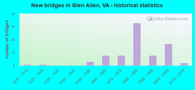
- New bridges - historical statistics
- 11910-1919
- 11920-1929
- 31950-1959
- 81960-1969
- 81970-1979
- 331980-1989
- 81990-1999
- 172000-2009
- 22010-2019
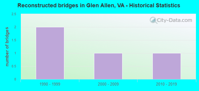
- Reconstructed bridges - Historical Statistics
- 21990-1999
- 12000-2009
- 12010-2019
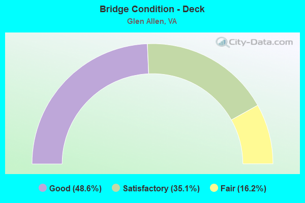
- Bridge Condition - Deck
- 48.6%Good
- 35.1%Satisfactory
- 16.2%Fair
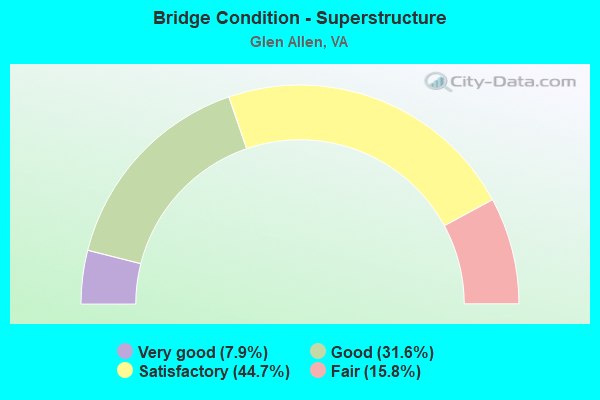
- Bridge Condition - Superstructure
- 7.9%Very good
- 31.6%Good
- 44.7%Satisfactory
- 15.8%Fair
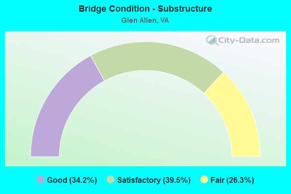
- Bridge Condition - Substructure
- 34.2%Good
- 39.5%Satisfactory
- 26.3%Fair
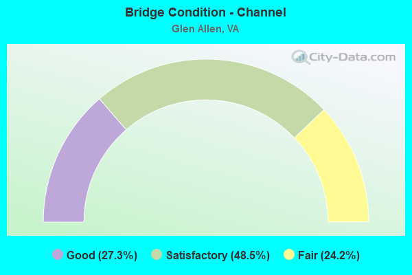
- Bridge Condition - Channel
- 27.3%Good
- 48.5%Satisfactory
- 24.2%Fair
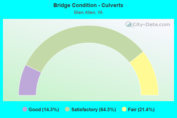
- Bridge Condition - Culverts
- 14.3%Good
- 64.3%Satisfactory
- 21.4%Fair
Find on map >> Show street view
Structure Number: 26365, Location: .10 656 EBL & .05 95 NBL (Lat: 37.686797, Lng: -77.451019), Route carried "on" structure: Ramp County highway 656, Year Built: 2004, Status: Open, Structure Length: 5.57m (18.27ft), Average Daily Traffic: 1,316 (year 2020), Average Future Daily Traffic: 1,842 (year 2040), Design Load: HS 20+Mod, Features Intersected: LICKINGHOLE CREEK
Minimum Vertical Clearance: 30+ m (98+ ft), Kilometerpoint: 0.000, Lanes on structure: 1, Base Highway Network: Yes, Owner: State Highway Agency, Approaching Roadway Width: 9.1m (29.9ft), Skew: 3 degrees, Material/Design: Steel continuous, Design/Construction: Stringer/Multi-beam, Number Of Spans In Main Unit: 3, Length of Maximum Span: 21.3m (69.9ft), Curb-To-Curb Width: 9.1m (29.9ft), Out-to-Out Width: 10.2m (33.5ft)
Condition: Deck: Good, Superstructure: Good, Substructure: Satisfactory, Channel: Satisfactory, Operating Rating: 56.8 metric tons, Method Used To Determine Operating Rating: Load and Resistance Factor (LRFR), Inventory Rating: 43.7 metric tons, Method Used To Determine Inventory Rating: Load and Resistance Factor (LRFR), Structural Evaluation: Equal to present minimum criteria, Deck Geometry: Superior to present desirable criteria, Waterway Adequacy: Equal to present desirable criteria, Approach Roadway Alignment: Equal to present desirable criteria, Designated Inspection Frequency: Every 24 months, Inspection Date: April 2021, Deck Structure Type: Concrete Cast-file-Place, Wearing Surface/Protective System: Deck Protection: Epoxy Coated Reinforcing
Find on map >> Show street view
Structure Number: 26366, Location: .20 656 WBL & .05 95 NBL (Lat: 37.690867, Lng: -77.449250), Route carried "on" structure: Ramp County highway 656, Year Built: 2004, Status: Open, Structure Length: 8.90m (29.20ft), Average Daily Traffic: 1,303 (year 2020), Average Future Daily Traffic: 1,615 (year 2040), Design Load: HS 20+Mod, Features Intersected: LICKINGHOLE CREEK
Minimum Vertical Clearance: 30+ m (98+ ft), Kilometerpoint: 0.000, Lanes on structure: 1, Base Highway Network: Yes, Owner: State Highway Agency, Approaching Roadway Width: 10.1m (33.1ft), Skew: 2 degrees, Material/Design: Steel continuous, Design/Construction: Stringer/Multi-beam, Number Of Spans In Main Unit: 3, Length of Maximum Span: 33.5m (109.9ft), Curb-To-Curb Width: 9.1m (29.9ft), Out-to-Out Width: 10.2m (33.5ft)
Condition: Deck: Satisfactory, Superstructure: Good, Substructure: Good, Channel: Good, Operating Rating: 72.8 metric tons, Method Used To Determine Operating Rating: Load and Resistance Factor (LRFR), Inventory Rating: 56.2 metric tons, Method Used To Determine Inventory Rating: Load and Resistance Factor (LRFR), Structural Evaluation: Better than present minimum criteria, Deck Geometry: Superior to present desirable criteria, Waterway Adequacy: Superior to present desirable criteria, Approach Roadway Alignment: Equal to present desirable criteria, Designated Inspection Frequency: Every 24 months, Inspection Date: April 2021, Deck Structure Type: Concrete Cast-file-Place, Wearing Surface/Protective System: Deck Protection: Epoxy Coated Reinforcing
Find on map >> Show street view
Structure Number: 26368, Location: .10 95 NBL & .30 656 EBL (Lat: 37.685700, Lng: -77.451164), Route carried "on" structure: Ramp Interstate 95, Year Built: 2004, Status: Open, Structure Length: 5.76m (18.90ft), Average Daily Traffic: 8,854 (year 2020), Truck Traffic: 14%, Average Future Daily Traffic: 12,396 (year 2040), Design Load: HS 20+Mod, Features Intersected: STONY RUN CREEK
Minimum Vertical Clearance: 30+ m (98+ ft), Kilometerpoint: 0.000, Lanes on structure: 1, Base Highway Network: Yes, Owner: State Highway Agency, Approaching Roadway Width: 9.1m (29.9ft), Material/Design: Prestressed concrete continuous, Design/Construction: Stringer/Multi-beam, Number Of Spans In Main Unit: 3, Length of Maximum Span: 19.2m (63.0ft), Curb or Sidewalk Widths: Left: 0.5m (1.6ft), Right: 0.5m (1.6ft), Curb-To-Curb Width: 9.1m (29.9ft), Out-to-Out Width: 10.2m (33.5ft)
Condition: Deck: Good, Superstructure: Very good, Substructure: Good, Channel: Satisfactory, Operating Rating: 89.8 metric tons, Method Used To Determine Operating Rating: Load and Resistance Factor (LRFR), Inventory Rating: 79.8 metric tons, Method Used To Determine Inventory Rating: Load and Resistance Factor (LRFR), Structural Evaluation: Better than present minimum criteria, Deck Geometry: Superior to present desirable criteria, Waterway Adequacy: Superior to present desirable criteria, Approach Roadway Alignment: Equal to present desirable criteria, Designated Inspection Frequency: Every 24 months, Inspection Date: March 2021, Deck Structure Type: Concrete Cast-file-Place, Wearing Surface/Protective System: Deck Protection: Epoxy Coated Reinforcing
Find on map >> Show street view
Structure Number: 26369, Location: .10 95 NBL & .20 656 WBL (Lat: 37.690167, Lng: -77.450547), Route carried "on" structure: Ramp Interstate 95, Year Built: 2004, Status: Open, Structure Length: 7.63m (25.03ft), Average Daily Traffic: 4,043 (year 2020), Average Future Daily Traffic: 5,660 (year 2040), Design Load: HS 20+Mod, Features Intersected: LICKINGHOLE CREEK
Minimum Vertical Clearance: 30+ m (98+ ft), Kilometerpoint: 0.000, Lanes on structure: 1, Base Highway Network: Yes, Owner: State Highway Agency, Approaching Roadway Width: 9.1m (29.9ft), Skew: 1 degrees, Material/Design: Steel continuous, Design/Construction: Stringer/Multi-beam, Number Of Spans In Main Unit: 3, Length of Maximum Span: 29.9m (98.1ft), Curb-To-Curb Width: 9.1m (29.9ft), Out-to-Out Width: 10.2m (33.5ft)
Condition: Deck: Good, Superstructure: Good, Substructure: Good, Channel: Satisfactory, Operating Rating: 53.5 metric tons, Method Used To Determine Operating Rating: Load and Resistance Factor (LRFR), Inventory Rating: 40.8 metric tons, Method Used To Determine Inventory Rating: Load and Resistance Factor (LRFR), Structural Evaluation: Better than present minimum criteria, Deck Geometry: Superior to present desirable criteria, Waterway Adequacy: Superior to present desirable criteria, Approach Roadway Alignment: Equal to present desirable criteria, Designated Inspection Frequency: Every 24 months, Inspection Date: April 2021, Deck Structure Type: Concrete Cast-file-Place, Wearing Surface/Protective System: Deck Protection: Epoxy Coated Reinforcing
Find on map >> Show street view
Structure Number: 26371, Location: .20 fr 656 & 2.4 to 802 (Lat: 37.689811, Lng: -77.460108), Route carried "on" structure: County highway 782, Year Built: 2002, Status: Open, Structure Length: 5.43m (17.81ft), Average Daily Traffic: 6,448 (year 2008), Average Future Daily Traffic: 7,480 (year 2040), Design Load: HS 20+Mod, Features Intersected: STONY RUN CREEK, Facility Carried by Structure: LAKERIDGE PARKWAY
Minimum Vertical Clearance: 30+ m (98+ ft), Kilometerpoint: 0.000, Lanes on structure: 2, Owner: State Highway Agency, Approaching Roadway Width: 15.8m (51.8ft), Material/Design: Steel continuous, Design/Construction: Stringer/Multi-beam, Number Of Spans In Main Unit: 3, Length of Maximum Span: 23.2m (76.1ft), Curb or Sidewalk Widths: Left: 0.2m (0.7ft), Right: 0.2m (0.7ft), Curb-To-Curb Width: 15.8m (51.8ft), Out-to-Out Width: 16.9m (55.4ft)
Condition: Deck: Good, Superstructure: Very good, Substructure: Good, Channel: Good, Operating Rating: 53.9 metric tons, Method Used To Determine Operating Rating: Load and Resistance Factor (LRFR), Inventory Rating: 41.8 metric tons, Method Used To Determine Inventory Rating: Load and Resistance Factor (LRFR), Structural Evaluation: Better than present minimum criteria, Deck Geometry: Superior to present desirable criteria, Waterway Adequacy: Equal to present desirable criteria, Approach Roadway Alignment: Equal to present desirable criteria, Designated Inspection Frequency: Every 24 months, Inspection Date: March 2021, Deck Structure Type: Concrete Cast-file-Place, Wearing Surface/Protective System: Deck Protection: Epoxy Coated Reinforcing
Find on map >> Show street view
Structure Number: 27369, Location: .0 HANOV CL & .0 HENRI CL (Lat: 37.680003, Lng: -77.454569), Route carried "on" structure: County highway 782, Year Built: 2002, Status: Open, Structure Length: 5.80m (19.03ft), Average Daily Traffic: 4,800 (year 2019), Average Future Daily Traffic: 4,296 (year 2025), Design Load: HS 20+Mod, Features Intersected: CHICKAHOMINY RIVER, Facility Carried by Structure: Lakeridge Parkway
Minimum Vertical Clearance: 30+ m (98+ ft), Kilometerpoint: 20.161, Lanes on structure: 4, Owner: State Highway Agency, Approaching Roadway Width: 16.5m (54.1ft), Skew: 20 degrees, Material/Design: Prestressed concrete continuous, Design/Construction: Stringer/Multi-beam, Number Of Spans In Main Unit: 3, Length of Maximum Span: 18.4m (60.4ft), Curb-To-Curb Width: 16.5m (54.1ft), Out-to-Out Width: 21.7m (71.2ft)
Condition: Deck: Good, Superstructure: Good, Substructure: Good, Channel: Satisfactory, Operating Rating: 78.7 metric tons, Method Used To Determine Operating Rating: Load and Resistance Factor (LRFR), Inventory Rating: 49.9 metric tons, Method Used To Determine Inventory Rating: Load and Resistance Factor (LRFR), Structural Evaluation: Better than present minimum criteria, Deck Geometry: Meets minimum limits, Waterway Adequacy: Equal to present desirable criteria, Approach Roadway Alignment: Equal to present desirable criteria, Designated Inspection Frequency: Every 24 months, Inspection Date: September 2020, Deck Structure Type: Concrete Cast-file-Place, Wearing Surface/Protective System: Deck Protection: Epoxy Coated Reinforcing
Find on map >> Show street view
Structure Number: 2843, Location: 0.30 FR HUNTON PARK LANE (Lat: 37.685417, Lng: -77.531278), Route carried "on" structure: County highway , Year Built: 2004, Status: Open, Structure Length: 0.73m (2.40ft), Average Daily Traffic: 4,398 (year 2013), Truck Traffic: 3%, Average Future Daily Traffic: 10,000 (year 2035), Design Load: HS 20, Features Intersected: HOLLADAY BRANCH, Facility Carried by Structure: HUNTON PARK BLVD
Minimum Vertical Clearance: 30+ m (98+ ft), Kilometerpoint: 0.000, Lanes on structure: 4, Owner: County Highway Agency, Approaching Roadway Width: 7.9m (25.9ft), Skew: 23 degrees, Material/Design: Concrete, Design/Construction: Culvert, Number Of Spans In Main Unit: 2, Length of Maximum Span: 3.0m (9.8ft), Curb or Sidewalk Widths: Left: 1.5m (4.9ft), Right: 1.5m (4.9ft)
Condition: Channel: Satisfactory, Culverts: Good, Operating Rating: 89.8 metric tons, Method Used To Determine Operating Rating: Field evaluation and documented engineering judgment, Inventory Rating: 89.8 metric tons, Method Used To Determine Inventory Rating: Field evaluation and documented engineering judgment, Structural Evaluation: Better than present minimum criteria, Waterway Adequacy: Equal to present desirable criteria, Approach Roadway Alignment: Equal to present desirable criteria, Designated Inspection Frequency: Every 24 months, Inspection Date: September 2020
Find on map >> Show street view
Structure Number: 29164, Location: 1.40 FR 656 & 1.20 TO 802 (Lat: 37.704492, Lng: -77.452661), Route carried "on" structure: County highway 782, Year Built: 2008, Status: Open, Structure Length: 2.26m (7.41ft), Average Daily Traffic: 2,188 (year 2020), Truck Traffic: 3%, Average Future Daily Traffic: 3,000 (year 2040), Design Load: HS 20+Mod, Features Intersected: LICKINGHOLE CREEK, Facility Carried by Structure: LAKERIDGE PARKWAY
Minimum Vertical Clearance: 30+ m (98+ ft), Kilometerpoint: 0.000, Lanes on structure: 4, Owner: State Highway Agency, Approaching Roadway Width: 16.5m (54.1ft), Skew: 2 degrees, Material/Design: Prestressed concrete, Design/Construction: Box Beam or Girders - Multiple, Number Of Spans In Main Unit: 1, Length of Maximum Span: 21.6m (70.9ft), Curb or Sidewalk Widths: Left: 1.9m (6.2ft), Right: 1.9m (6.2ft), Curb-To-Curb Width: 17.9m (58.7ft), Out-to-Out Width: 21.0m (68.9ft)
Condition: Deck: Good, Superstructure: Good, Substructure: Good, Channel: Satisfactory, Operating Rating: 73.4 metric tons, Method Used To Determine Operating Rating: Load and Resistance Factor (LRFR), Inventory Rating: 56.6 metric tons, Method Used To Determine Inventory Rating: Load and Resistance Factor (LRFR), Structural Evaluation: Better than present minimum criteria, Deck Geometry: Somewhat better than minimum adequacy, Waterway Adequacy: Better than present minimum criteria, Approach Roadway Alignment: Equal to present desirable criteria, Designated Inspection Frequency: Every 24 months, Inspection Date: June 2021, Deck Structure Type: Concrete Cast-file-Place, Wearing Surface/Protective System: Deck Protection: Epoxy Coated Reinforcing
Find on map >> Show street view
Structure Number: 29485, Location: 0.00 Hanover/Henrico CL (Lat: 37.700722, Lng: -77.512861), Route carried "on" structure: County highway 625, Year Built: 2017, Status: Open, Structure Length: 2.87m (9.42ft), Average Daily Traffic: 862 (year 2020), Truck Traffic: 1%, Average Future Daily Traffic: 948 (year 2040), Design Load: HL 93, Features Intersected: CHICKAHOMINY RIVER, Facility Carried by Structure: GREENWOOD ROAD
Minimum Vertical Clearance: 30.45m (99.90ft), Kilometerpoint: 0.000, Lanes on structure: 2, Owner: State Highway Agency, Approaching Roadway Width: 7.5m (24.6ft), Material/Design: Steel, Design/Construction: Stringer/Multi-beam, Number Of Spans In Main Unit: 1, Length of Maximum Span: 27.3m (89.6ft), Curb-To-Curb Width: 8.5m (27.9ft), Out-to-Out Width: 9.0m (29.5ft)
Condition: Deck: Good, Superstructure: Very good, Substructure: Good, Channel: Satisfactory, Operating Rating: 65.3 metric tons, Method Used To Determine Operating Rating: Load and Resistance Factor (LRFR), Inventory Rating: 49.9 metric tons, Method Used To Determine Inventory Rating: Load and Resistance Factor (LRFR), Structural Evaluation: Better than present minimum criteria, Deck Geometry: Somewhat better than minimum adequacy, Waterway Adequacy: Equal to present minimum criteria, Approach Roadway Alignment: Equal to present desirable criteria, Designated Inspection Frequency: Every 24 months, Inspection Date: January 2022, Deck Structure Type: Concrete Cast-file-Place, Wearing Surface/Protective System: Wearing Surface: Monolithic Concrete, Deck Protection: Other Coated Reinforcing
Find on map >> Show street view
Structure Number: 31518, Location: .13frMtnRd .11toParkGreen (Lat: 37.662778, Lng: -77.493667), Route carried "on" structure: County highway , Year Built: 2017, Status: Open, Structure Length: 1.19m (3.90ft), Average Daily Traffic: 100 (year 2017), Average Future Daily Traffic: 118 (year 2038), Design Load: HS 20, Features Intersected: North Run, Facility Carried by Structure: Mount Glen Parkway
Minimum Vertical Clearance: 30+ m (98+ ft), Kilometerpoint: 0.000, Lanes on structure: 2, Owner: County Highway Agency, Approaching Roadway Width: 7.3m (24.0ft), Skew: 24 degrees, Material/Design: Steel, Design/Construction: Arch - Deck, Number Of Spans In Main Unit: 2, Length of Maximum Span: 5.5m (18.0ft), Curb-To-Curb Width: 7.3m (24.0ft), Out-to-Out Width: 7.3m (24.0ft)
Condition: Superstructure: Good, Substructure: Good, Channel: Satisfactory, Operating Rating: 54.5 metric tons, Method Used To Determine Operating Rating: Field evaluation and documented engineering judgment, Inventory Rating: 32.7 metric tons, Method Used To Determine Inventory Rating: Field evaluation and documented engineering judgment, Structural Evaluation: Better than present minimum criteria, Deck Geometry: Equal to present minimum criteria, Waterway Adequacy: Equal to present minimum criteria, Approach Roadway Alignment: Equal to present desirable criteria, Designated Inspection Frequency: Every 24 months, Inspection Date: March 2021
Find on map >> Show street view
Structure Number: 9622, Location: 0.04TELEGR RD0.17F-110 (Lat: 37.663711, Lng: -77.449519), Route carried "under" structure: Interstate 95, Year Built: 1980, Structure Length: 0. m, Average Daily Traffic: 67,560 (year 1994), Features Intersected: I-95 & I-95 CONN, Facility Carried by Structure: VA CENTER PARKWAY
Minimum Vertical Clearance: 5.97m (19.59ft), Kilometerpoint: 137.328, Lanes on structure: 4, Lanes under structure: 11, Material/Design: Steel continuous, Design/Construction: Stringer/Multi-beam, Length of Maximum Span: 45.7m (149.9ft)
Find on map >> Show street view
Structure Number: 963, Location: 0.40 FR 1 & 1.30 MAG PKWY (Lat: 37.640142, Lng: -77.452831), Route carried "under" structure: Interstate 95, Year Built: 1962, Structure Length: 0. m, Average Daily Traffic: 91,667 (year 2008), Truck Traffic: 4%, Features Intersected: I 95, Facility Carried by Structure: SCOTT ROAD
Minimum Vertical Clearance: 4.57m (14.99ft), Kilometerpoint: 134.899, Lanes on structure: 2, Lanes under structure: 8, Material/Design: Steel, Design/Construction: Stringer/Multi-beam, Length of Maximum Span: 24.8m (81.4ft)
Find on map >> Show street view
Structure Number: 9682, Location: .55 MTN RD/1.13 OLD WASH (Lat: 37.681183, Lng: -77.522581), Route carried "under" structure: Interstate 295, Year Built: 1980, Structure Length: 0. m, Average Daily Traffic: 55,000 (year 2020), Truck Traffic: 7%, Features Intersected: I-295, Facility Carried by Structure: MILL ROAD
Minimum Vertical Clearance: 6.93m (22.74ft), Kilometerpoint: 8.142, Lanes on structure: 4, Lanes under structure: 6, Material/Design: Steel continuous, Design/Construction: Stringer/Multi-beam, Length of Maximum Span: 33.5m (109.9ft)
Find on map >> Show street view
Structure Number: 9688, Location: .25frMNT & .35 to 625 (Lat: 37.666728, Lng: -77.484847), Route carried "under" structure: Interstate 295, Year Built: 1980, Structure Length: 0. m, Average Daily Traffic: 59,000 (year 2008), Truck Traffic: 7%, Features Intersected: ROUTE I-295, Facility Carried by Structure: WOODMAN ROAD
Minimum Vertical Clearance: 5.33m (17.49ft), Kilometerpoint: 11.858, Lanes on structure: 6, Lanes under structure: 8, Material/Design: Steel continuous, Design/Construction: Stringer/Multi-beam, Length of Maximum Span: 39.4m (129.3ft)
Find on map >> Show street view
Structure Number: 972, Location: 1.3 fr 73 & 1.54toHanoCo (Lat: 37.658036, Lng: -77.459953), Route carried "under" structure: Ramp Interstate 295, Year Built: 1981, Structure Length: 0. m, Average Daily Traffic: 2,000 (year 1997), Features Intersected: RTE 0295 & COLL DIST RDS, Facility Carried by Structure: BROOK ROAD
Minimum Vertical Clearance: 5.71m (18.73ft), Kilometerpoint: 0.000, Lanes on structure: 8, Lanes under structure: 2, Material/Design: Steel continuous, Design/Construction: Stringer/Multi-beam, Length of Maximum Span: 35.1m (115.2ft)
Find on map >> Show street view
Structure Number: 972, Location: 1.3 fr 73 & 1.54toHanoCo (Lat: 37.658036, Lng: -77.459953), Route carried "under" structure: Ramp Interstate 295, Year Built: 1981, Structure Length: 0. m, Average Daily Traffic: 2,000 (year 1997), Features Intersected: RTE 0295 & COLL DIST RDS, Facility Carried by Structure: BROOK ROAD
Minimum Vertical Clearance: 5.11m (16.77ft), Kilometerpoint: 0.000, Lanes on structure: 8, Lanes under structure: 2, Material/Design: Steel continuous, Design/Construction: Stringer/Multi-beam, Length of Maximum Span: 35.1m (115.2ft)
Find on map >> Show street view
Structure Number: 972, Location: 1.3 fr 73 & 1.54toHanoCo (Lat: 37.658036, Lng: -77.459953), Route carried "under" structure: Interstate 295, Year Built: 1981, Structure Length: 0. m, Average Daily Traffic: 32,515 (year 2008), Truck Traffic: 2%, Features Intersected: RTE 0295 & COLL DIST RDS, Facility Carried by Structure: BROOK ROAD
Minimum Vertical Clearance: 5.74m (18.83ft), Kilometerpoint: 14.690, Lanes on structure: 8, Lanes under structure: 4, Material/Design: Steel continuous, Design/Construction: Stringer/Multi-beam, Length of Maximum Span: 35.1m (115.2ft)
Find on map >> Show street view
Structure Number: 9828, Location: 0.44 RTE 1 & 1.9 RTE 301 (Lat: 37.636089, Lng: -77.452097), Route carried "under" structure: Interstate 95, Year Built: 1978, Structure Length: 0. m, Average Daily Traffic: 102,000 (year 2019), Truck Traffic: 8%, Features Intersected: ROUTE I-95, Facility Carried by Structure: WBL PARHAM ROAD
Minimum Vertical Clearance: 4.78m (15.68ft), Kilometerpoint: 134.175, Lanes on structure: 3, Lanes under structure: 8, Material/Design: Steel continuous, Design/Construction: Stringer/Multi-beam, Length of Maximum Span: 30.7m (100.7ft)
Find on map >> Show street view
Structure Number: 983, Location: .44 FR RT 1/.84 TO RT 301 (Lat: 37.635725, Lng: -77.452011), Route carried "under" structure: Interstate 95, Year Built: 1962, Structure Length: 0. m, Average Daily Traffic: 103,000 (year 2019), Truck Traffic: 8%, Features Intersected: ROUTE I-95, Facility Carried by Structure: EBL PARHAM ROAD
Minimum Vertical Clearance: 4.67m (15.32ft), Kilometerpoint: 134.158, Lanes on structure: 3, Lanes under structure: 8, Material/Design: Steel, Design/Construction: Stringer/Multi-beam, Length of Maximum Span: 25.3m (83.0ft)
Find on map >> Show street view
Structure Number: 9846, Location: 0.36I-295 & 1.31HANOV CO (Lat: 37.662886, Lng: -77.448431), Route carried "under" structure: Ramp Interstate 95, Year Built: 1980, Structure Length: 0. m, Average Daily Traffic: 8,000 (year 1994), Features Intersected: ROUTE 0095 CONNECTIONS
Minimum Vertical Clearance: 5.89m (19.32ft), Kilometerpoint: 0.000, Lanes on structure: 3, Lanes under structure: 5, Material/Design: Steel continuous, Design/Construction: Stringer/Multi-beam, Length of Maximum Span: 68.3m (224.1ft)
Find on map >> Show street view
Structure Number: 9848, Location: 0.70I-95 SBL 0.70I-295 EB (Lat: 37.657594, Lng: -77.445578), Route carried "under" structure: Interstate 295, Year Built: 1980, Structure Length: 0. m, Average Daily Traffic: 59,000 (year 1994), Truck Traffic: 8%, Features Intersected: WBL ROUTE 0295, Facility Carried by Structure: SBL ROUTE 0095CONN
Minimum Vertical Clearance: 5.38m (17.65ft), Kilometerpoint: 15.623, Lanes on structure: 3, Lanes under structure: 3, Material/Design: Steel continuous, Design/Construction: Stringer/Multi-beam, Length of Maximum Span: 37.5m (123.0ft)
Find on map >> Show street view
Structure Number: 985, Location: 0.60I-295 WBL0.80I-95 NBL (Lat: 37.656897, Lng: -77.443803), Route carried "under" structure: Interstate 295, Year Built: 1980, Structure Length: 0. m, Average Daily Traffic: 54,000 (year 2017), Truck Traffic: 9%, Features Intersected: WBL ROUTE 0295, Facility Carried by Structure: NBL ROUTE 0095CONN
Minimum Vertical Clearance: 5.33m (17.49ft), Kilometerpoint: 15.656, Lanes on structure: 2, Lanes under structure: 3, Material/Design: Steel continuous, Design/Construction: Stringer/Multi-beam, Length of Maximum Span: 41.5m (136.2ft)
Find on map >> Show street view
Structure Number: 9896, Location: 2.07 TO 33 & 1.23 TO WDMN (Lat: 37.676647, Lng: -77.503392), Route carried "under" structure: County highway , Year Built: 1979, Structure Length: 0. m, Average Daily Traffic: 1,100 (year 1994), Features Intersected: OLD WASH HWY & CSX TRANS, Facility Carried by Structure: EBL ROUTE 0295
Minimum Vertical Clearance: 8.33m (27.33ft), Kilometerpoint: 9.895, Lanes on structure: 3, Lanes under structure: 2, Material/Design: Steel, Design/Construction: Stringer/Multi-beam, Length of Maximum Span: 25.4m (83.3ft)
Find on map >> Show street view
Structure Number: 9898, Location: 2.07 TO 33 & 1.24 TO WDMN (Lat: 37.677056, Lng: -77.503389), Route carried "under" structure: County highway , Year Built: 1979, Structure Length: 0. m, Average Daily Traffic: 1,100 (year 1994), Features Intersected: OLD WASH HWY & CSX TRANS, Facility Carried by Structure: WBL ROUTE 0295
Minimum Vertical Clearance: 8.33m (27.33ft), Kilometerpoint: 9.879, Lanes on structure: 3, Lanes under structure: 2, Material/Design: Steel, Design/Construction: Stringer/Multi-beam, Length of Maximum Span: 25.8m (84.6ft)
Find on map >> Show street view
Structure Number: 9917, Location: 0.77 TO WOODMAN ROAD (Lat: 37.660625, Lng: -77.473381), Route carried "under" structure: County highway , Year Built: 1980, Structure Length: 0. m, Average Daily Traffic: 3,500 (year 2018), Truck Traffic: 1%, Features Intersected: GREENWOOD ROAD, Facility Carried by Structure: SBL ROUTE 0295
Minimum Vertical Clearance: 4.72m (15.49ft), Kilometerpoint: 1.126, Lanes on structure: 3, Lanes under structure: 2, Material/Design: Steel, Design/Construction: Stringer/Multi-beam, Length of Maximum Span: 28.5m (93.5ft)
Find on map >> Show street view
Structure Number: 9919, Location: 0.75 TO WOODMAN ROAD (Lat: 37.661336, Lng: -77.473575), Route carried "under" structure: County highway , Year Built: 1980, Structure Length: 0. m, Average Daily Traffic: 3,500 (year 2018), Truck Traffic: 1%, Features Intersected: GREENWOOD ROAD, Facility Carried by Structure: NBL I-295
Minimum Vertical Clearance: 4.93m (16.17ft), Kilometerpoint: 1.175, Lanes on structure: 3, Lanes under structure: 2, Material/Design: Steel, Design/Construction: Stringer/Multi-beam, Length of Maximum Span: 28.5m (93.5ft)
Find on map >> Show street view
Structure Number: 9921, Location: 2.32 TO NUCKOLS RD (Lat: 37.680225, Lng: -77.540619), Route carried "under" structure: US 33, Year Built: 1981, Structure Length: 0. m, Average Daily Traffic: 18,000 (year 2020), Truck Traffic: 1%, Features Intersected: ROUTE 33, Facility Carried by Structure: EBL I-295
Minimum Vertical Clearance: 5.36m (17.59ft), Kilometerpoint: 200.610, Lanes on structure: 4, Lanes under structure: 6, Material/Design: Steel continuous, Design/Construction: Stringer/Multi-beam, Length of Maximum Span: 31.1m (102.0ft)
Find on map >> Show street view
Structure Number: 9923, Location: 2.32 TO 695 (Lat: 37.680972, Lng: -77.540744), Route carried "under" structure: US 33, Year Built: 1981, Structure Length: 0. m, Average Daily Traffic: 17,000 (year 2020), Truck Traffic: 3%, Features Intersected: ROUTE 33, Facility Carried by Structure: NBL I-295
Minimum Vertical Clearance: 5.56m (18.24ft), Kilometerpoint: 200.530, Lanes on structure: 4, Lanes under structure: 6, Material/Design: Steel continuous, Design/Construction: Stringer/Multi-beam, Length of Maximum Span: 31.1m (102.0ft)
Find on map >> Show street view
Structure Number: 9925, Location: 0.51 FR 1 & 1.18 TO HCL (Lat: 37.657111, Lng: -77.451039), Route carried "under" structure: Interstate 95, Year Built: 1981, Structure Length: 0. m, Average Daily Traffic: 136,000 (year 2019), Truck Traffic: 13%, Features Intersected: I-95
Minimum Vertical Clearance: 5.08m (16.67ft), Kilometerpoint: 136.556, Lanes on structure: 2, Lanes under structure: 8, Material/Design: Steel continuous, Design/Construction: Stringer/Multi-beam, Length of Maximum Span: 35.7m (117.1ft)
Find on map >> Show street view
Structure Number: 9927, Location: 0.51 TO 1 & 1.18 TO HCL (Lat: 37.658314, Lng: -77.450872), Route carried "under" structure: Interstate 95, Year Built: 1981, Structure Length: 0. m, Average Daily Traffic: 136,000 (year 2019), Truck Traffic: 13%, Features Intersected: ROUTE 0095
Minimum Vertical Clearance: 5.51m (18.08ft), Kilometerpoint: 136.620, Lanes on structure: 2, Lanes under structure: 8, Material/Design: Steel continuous, Design/Construction: Stringer/Multi-beam, Length of Maximum Span: 35.7m (117.1ft)
Find on map >> Show street view
Structure Number: 9929, Location: 0.51 FR 1 TO 1.18 HAN CL (Lat: 37.657442, Lng: -77.450989), Route carried "under" structure: Interstate 95, Year Built: 1981, Structure Length: 0. m, Average Daily Traffic: 136,000 (year 2019), Truck Traffic: 13%, Features Intersected: RTE I 95
Minimum Vertical Clearance: 5.56m (18.24ft), Kilometerpoint: 136.572, Lanes on structure: 2, Lanes under structure: 8, Material/Design: Steel continuous, Design/Construction: Stringer/Multi-beam, Length of Maximum Span: 36.3m (119.1ft)
Find on map >> Show street view
Structure Number: 9931, Location: 0.51 FR 1 TO 1.18 H AN CL (Lat: 37.657986, Lng: -77.450931), Route carried "under" structure: Interstate 95, Year Built: 1981, Structure Length: 0. m, Average Daily Traffic: 136,000 (year 2019), Truck Traffic: 13%, Features Intersected: RTE I 95
Minimum Vertical Clearance: 5.26m (17.26ft), Kilometerpoint: 136.604, Lanes on structure: 2, Lanes under structure: 8, Material/Design: Steel continuous, Design/Construction: Stringer/Multi-beam, Length of Maximum Span: 36.0m (118.1ft)
Find on map >> Show street view
Structure Number: 24622, Location: 0.21 FR 782 & 0.85 TO 637 (Lat: 37.683544, Lng: -77.452606), Route carried "under" structure: Interstate 95, Year Built: 1996, Structure Length: 0. m, Average Daily Traffic: 128,497 (year 2008), Truck Traffic: 6%, Features Intersected: ROUTE I-95, Facility Carried by Structure: KINGS ACRE ROAD
Minimum Vertical Clearance: 5.69m (18.67ft), Kilometerpoint: 139.645, Lanes on structure: 2, Lanes under structure: 9, Material/Design: Steel continuous, Design/Construction: Stringer/Multi-beam, Length of Maximum Span: 46.9m (153.9ft)
Find on map >> Show street view
Structure Number: 24622, Location: 0.21 FR 782 & 0.85 TO 637 (Lat: 37.683544, Lng: -77.452606), Route carried "under" structure: Ramp Interstate 95, Year Built: 1996, Structure Length: 0. m, Average Daily Traffic: 5,000 (year 2003), Features Intersected: ROUTE I-95, Facility Carried by Structure: KINGS ACRE ROAD
Minimum Vertical Clearance: 5.54m (18.18ft), Kilometerpoint: 0.000, Lanes on structure: 2, Lanes under structure: 2, Material/Design: Steel continuous, Design/Construction: Stringer/Multi-beam, Length of Maximum Span: 46.9m (153.9ft)
Find on map >> Show street view
Structure Number: 2636, Location: 0.35 FR 623 & 0.80 TO 637 (Lat: 37.688064, Lng: -77.452428), Route carried "under" structure: Interstate 95, Year Built: 2004, Structure Length: 0. m, Average Daily Traffic: 134,500 (year 2019), Truck Traffic: 13%, Features Intersected: RTE 95 & LICKINGHOLE CK, Facility Carried by Structure: RELOCATED RTE 656
Minimum Vertical Clearance: 5.51m (18.08ft), Kilometerpoint: 140.160, Lanes on structure: 6, Lanes under structure: 7, Material/Design: Steel continuous, Design/Construction: Stringer/Multi-beam, Length of Maximum Span: 48.8m (160.1ft)
Find on map >> Show street view
Structure Number: 2636, Location: 0.35 FR 623 & 0.80 TO 637 (Lat: 37.688064, Lng: -77.452428), Route carried "under" structure: Ramp Interstate 95, Year Built: 2004, Structure Length: 0. m, Average Daily Traffic: 6,200 (year 2019), Features Intersected: RTE 95 & LICKINGHOLE CK, Facility Carried by Structure: RELOCATED RTE 656
Minimum Vertical Clearance: 5.79m (19.00ft), Kilometerpoint: 0.000, Lanes on structure: 6, Lanes under structure: 2, Material/Design: Steel continuous, Design/Construction: Stringer/Multi-beam, Length of Maximum Span: 48.8m (160.1ft)
Find on map >> Show street view
Structure Number: 26361, Location: 0.20 FR 782 & 1.00 TO 637 (Lat: 37.687489, Lng: -77.456789), Route carried "under" structure: Ramp County highway 656, Year Built: 2004, Structure Length: 0. m, Average Daily Traffic: 16,000 (year 2019), Features Intersected: RAMP E1 & STONY RUN CK
Minimum Vertical Clearance: 5.54m (18.18ft), Kilometerpoint: 0.000, Lanes on structure: 6, Lanes under structure: 1, Material/Design: Steel continuous, Design/Construction: Stringer/Multi-beam, Length of Maximum Span: 41.1m (134.8ft)
Find on map >> Show street view
Structure Number: 26362, Location: .20 656 WBL & .80 95 SBL (Lat: 37.690631, Lng: -77.449753), Route carried "under" structure: Interstate 95, Year Built: 2004, Structure Length: 0. m, Average Daily Traffic: 134,000 (year 2019), Truck Traffic: 13%, Features Intersected: RTE 95 & LICKINGHOLE CK, Facility Carried by Structure: ROUTE 656 RAMP E1
Minimum Vertical Clearance: 5.82m (19.09ft), Kilometerpoint: 140.434, Lanes on structure: 1, Lanes under structure: 9, Material/Design: Steel continuous, Design/Construction: Stringer/Multi-beam, Length of Maximum Span: 67.7m (222.1ft)
Find on map >> Show street view
Structure Number: 26362, Location: .20 656 WBL & .80 95 SBL (Lat: 37.690631, Lng: -77.449753), Route carried "under" structure: Ramp Interstate 95, Year Built: 2004, Structure Length: 0. m, Average Daily Traffic: 1,600 (year 2019), Features Intersected: RTE 95 & LICKINGHOLE CK, Facility Carried by Structure: ROUTE 656 RAMP E1
Minimum Vertical Clearance: 5.03m (16.50ft), Kilometerpoint: 0.000, Lanes on structure: 1, Lanes under structure: 1, Material/Design: Steel continuous, Design/Construction: Stringer/Multi-beam, Length of Maximum Span: 67.7m (222.1ft)