Bridge Statistics for Gonzales, Louisiana (LA)
Condition, Traffic, Stress, Structural Evaluation, Project Costs
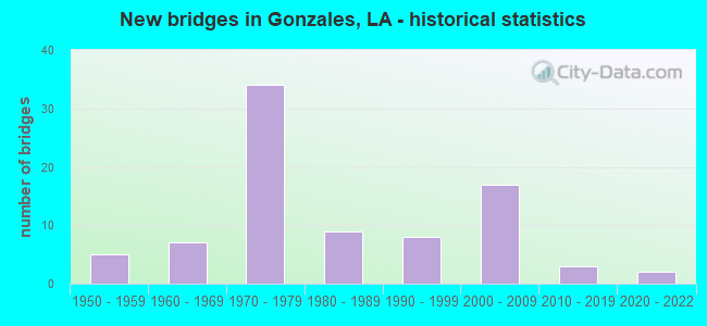
- New bridges - historical statistics
- 51950-1959
- 71960-1969
- 341970-1979
- 91980-1989
- 81990-1999
- 172000-2009
- 32010-2019
- 22020-2022
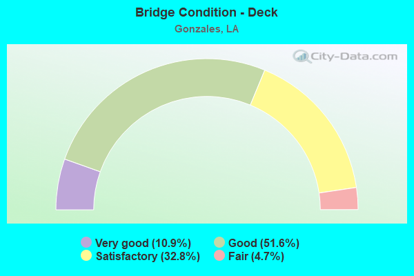
- Bridge Condition - Deck
- 10.9%Very good
- 51.6%Good
- 32.8%Satisfactory
- 4.7%Fair
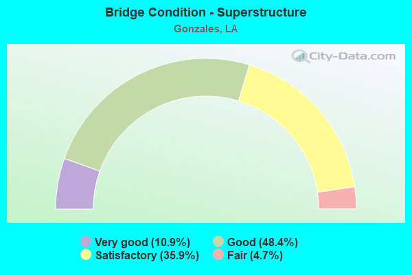
- Bridge Condition - Superstructure
- 10.9%Very good
- 48.4%Good
- 35.9%Satisfactory
- 4.7%Fair
- Bridge Condition - Substructure
- 9.4%Very good
- 45.3%Good
- 29.7%Satisfactory
- 9.4%Fair
- 3.1%Poor
- 3.1%Serious
- Bridge Condition - Channel
- 29.1%Very good
- 39.2%Good
- 29.1%Satisfactory
- 2.5%Fair
- Bridge Condition - Culverts
- 5.3%Very good
- 73.7%Good
- 21.1%Satisfactory
Find on map >> Show street view
Structure Number: 610300000610175, Location: 1.5 MILES WEST OF LA 44 (Lat: 30.225381, Lng: -90.945919), Route carried "on" structure: County highway , Year Built: 2007, Status: Posted for load, Structure Length: 1.83m (6.00ft), Average Daily Traffic: 120 (year 2019), Average Future Daily Traffic: 1,207 (year 2036), Design Load: HS 20, Features Intersected: BAYOU FRANCOIS TRIB., Facility Carried by Structure: W Worthy Rd
Minimum Vertical Clearance: 30+ m (98+ ft), Kilometerpoint: 0.000, Lanes on structure: 2, Owner: County Highway Agency, Approaching Roadway Width: 7.3m (24.0ft), Skew: 36 degrees, Material/Design: Concrete, Design/Construction: Slab, Number Of Spans In Main Unit: 3, Length of Maximum Span: 6.1m (20.0ft), Curb-To-Curb Width: 7.1m (23.3ft), Out-to-Out Width: 8.1m (26.6ft)
Condition: Deck: Very good, Superstructure: Very good, Substructure: Good, Channel: Very good, Operating Rating: 36.3 metric tons, Method Used To Determine Operating Rating: Load and Resistance Factor Rating (LRFR) rating reported by rating factor(RF) method using HL-93 loadings, Inventory Rating: 28.2 metric tons, Method Used To Determine Inventory Rating: Load and Resistance Factor Rating (LRFR) rating reported by rating factor(RF) method using HL-93 loadings, Structural Evaluation: Better than present minimum criteria, Deck Geometry: Meets minimum limits, Waterway Adequacy: Equal to present desirable criteria, Approach Roadway Alignment: Equal to present desirable criteria, Designated Inspection Frequency: Every 24 months, Inspection Date: January 2021, Deck Structure Type: Concrete Precast Panels, Wearing Surface/Protective System: Wearing Surface: Monolithic Concrete
Find on map >> Show street view
Structure Number: 610300000610183, Location: 0.01 Mi E of LA 429 (Lat: 30.235700, Lng: -90.963219), Route carried "on" structure: County highway , Year Built: 2000, Status: Posted for load, Structure Length: 1.92m (6.30ft), Average Daily Traffic: 10 (year 2019), Design Load: H 15, Features Intersected: New River, Facility Carried by Structure: Moise Rd
Minimum Vertical Clearance: 30+ m (98+ ft), Kilometerpoint: 0.000, Lanes on structure: 1, Owner: County Highway Agency, Approaching Roadway Width: 4.6m (15.1ft), Skew: 30 degrees, Material/Design: Wood or Timber, Design/Construction: Stringer/Multi-beam, Number Of Spans In Main Unit: 5, Length of Maximum Span: 3.7m (12.1ft), Curb-To-Curb Width: 4.7m (15.4ft), Out-to-Out Width: 5.0m (16.4ft)
Condition: Deck: Satisfactory, Superstructure: Satisfactory, Substructure: Satisfactory, Channel: Good, Operating Rating: 22.7 metric tons, Method Used To Determine Operating Rating: Allowable Stress (AS), Inventory Rating: 16.3 metric tons, Method Used To Determine Inventory Rating: Allowable Stress (AS), Structural Evaluation: Somewhat better than minimum adequacy, Deck Geometry: Better than present minimum criteria, Waterway Adequacy: Equal to present desirable criteria, Approach Roadway Alignment: Somewhat better than minimum adequacy, Bridge Posting: Required (Relationship of Operating Rating to Maximum Legal Load: 0.1 - 9.9% below), Designated Inspection Frequency: Every 24 months, Inspection Date: January 2021, Deck Structure Type: Wood or Timber, Wearing Surface/Protective System: Wearing Surface: Wood or Timber
Find on map >> Show street view
Structure Number: 610300000610279, Location: 0.3 MILES NORTH OF JCT LA (Lat: 30.273661, Lng: -90.904361), Route carried "on" structure: County highway , Year Built: 2009, Status: Posted for load, Structure Length: 1.04m (3.41ft), Average Daily Traffic: 1,200 (year 2019), Design Load: HS 20, Features Intersected: BERT ALLEN DITCH, Facility Carried by Structure: Roddy Rd
Minimum Vertical Clearance: 30+ m (98+ ft), Kilometerpoint: 0.000, Lanes on structure: 2, Owner: Town or Township Highway Agency, Approaching Roadway Width: 7.3m (24.0ft), Skew: 30 degrees, Material/Design: Concrete, Design/Construction: Culvert, Number Of Spans In Main Unit: 3, Length of Maximum Span: 3.0m (9.8ft)
Condition: Channel: Satisfactory, Culverts: Good, Operating Rating: 27.5 metric tons, Method Used To Determine Operating Rating: Load and Resistance Factor Rating (LRFR) rating reported by rating factor(RF) method using HL-93 loadings, Inventory Rating: 21.4 metric tons, Method Used To Determine Inventory Rating: Load and Resistance Factor Rating (LRFR) rating reported by rating factor(RF) method using HL-93 loadings, Structural Evaluation: Somewhat better than minimum adequacy, Waterway Adequacy: Equal to present desirable criteria, Approach Roadway Alignment: Equal to present desirable criteria, Bridge Posting: Required (Relationship of Operating Rating to Maximum Legal Load: 20.0 - 29.9% below), Designated Inspection Frequency: Every 24 months, Inspection Date: April 2021, Deck Structure Type: Concrete Precast Panels
Find on map >> Show street view
Structure Number: 610300000610288, Location: 0.7 Mi. E of LA 933 (Lat: 30.338231, Lng: -90.861689), Route carried "on" structure: State highway 42, Year Built: 2011, Status: Open, Structure Length: 7.32m (24.02ft), Average Daily Traffic: 9,200 (year 2016), Truck Traffic: 7%, Average Future Daily Traffic: 15,470 (year 2036), Design Load: HS 20, Features Intersected: AMITE RIVER RELIEF
Minimum Vertical Clearance: 30+ m (98+ ft), Kilometerpoint: 12.213, Lanes on structure: 2, Owner: State Highway Agency, Approaching Roadway Width: 7.3m (24.0ft), Skew: 30 degrees, Material/Design: Prestressed concrete continuous, Design/Construction: Stringer/Multi-beam, Number Of Spans In Main Unit: 6, Length of Maximum Span: 12.2m (40.0ft), Curb-To-Curb Width: 12.2m (40.0ft), Out-to-Out Width: 13.0m (42.7ft)
Condition: Deck: Very good, Superstructure: Very good, Substructure: Good, Channel: Very good, Operating Rating: 55.1 metric tons, Method Used To Determine Operating Rating: Load and Resistance Factor Rating (LRFR) rating reported by rating factor(RF) method using HL-93 loadings, Inventory Rating: 37.3 metric tons, Method Used To Determine Inventory Rating: Load and Resistance Factor Rating (LRFR) rating reported by rating factor(RF) method using HL-93 loadings, Structural Evaluation: Better than present minimum criteria, Deck Geometry: Somewhat better than minimum adequacy, Waterway Adequacy: Better than present minimum criteria, Approach Roadway Alignment: Better than present minimum criteria, Designated Inspection Frequency: Every 24 months, Inspection Date: October 2020, Deck Structure Type: Concrete Cast-file-Place, Wearing Surface/Protective System: Wearing Surface: Monolithic Concrete
Find on map >> Show street view
Structure Number: 610300000610318, Location: 0.4 MI W of US 61 (Lat: 30.262189, Lng: -90.940000), Route carried "on" structure: County highway , Year Built: 2020, Status: Open, Structure Length: 1.86m (6.10ft), Average Daily Traffic: 2,640 (year 2020), Truck Traffic: 10%, Average Future Daily Traffic: 3,150 (year 2038), Design Load: Greater than HL93, Features Intersected: Bayou Narcisse, Facility Carried by Structure: Babin Rd
Minimum Vertical Clearance: 30+ m (98+ ft), Kilometerpoint: 3.121, Lanes on structure: 2, Owner: County Highway Agency, Approaching Roadway Width: 8.5m (27.9ft), Skew: 4 degrees, Material/Design: Concrete, Design/Construction: Slab, Number Of Spans In Main Unit: 3, Length of Maximum Span: 6.1m (20.0ft), Curb-To-Curb Width: 8.5m (27.9ft), Out-to-Out Width: 9.4m (30.8ft)
Condition: Deck: Very good, Superstructure: Very good, Substructure: Very good, Channel: Good, Operating Rating: 57.3 metric tons, Method Used To Determine Operating Rating: Assigned ratings based on Load and Resistance Factor Design (LRFD) reported by rating factor (RF) using HL93 loadings, Inventory Rating: 44.1 metric tons, Method Used To Determine Inventory Rating: Assigned ratings based on Load and Resistance Factor Design (LRFD) reported by rating factor (RF) using HL93 loadings, Structural Evaluation: Equal to present desirable criteria, Deck Geometry: Meets minimum limits, Waterway Adequacy: Equal to present desirable criteria, Approach Roadway Alignment: Equal to present desirable criteria, Designated Inspection Frequency: Every 24 months, Inspection Date: April 2021, Deck Structure Type: Concrete Cast-file-Place
Find on map >> Show street view
Structure Number: 610300000610362, Location: 0.26 MILES NORTH OF LA.30 (Lat: 30.214381, Lng: -90.971011), Route carried "on" structure: County highway , Year Built: 2016, Status: Open, Structure Length: 0.67m (2.20ft), Average Daily Traffic: 120 (year 2019), Average Future Daily Traffic: 70 (year 2036), Design Load: HS 20, Features Intersected: DRAINAGE BAYOU, Facility Carried by Structure: W Robert Wilson Rd
Minimum Vertical Clearance: 30+ m (98+ ft), Kilometerpoint: 0.430, Lanes on structure: 2, Owner: County Highway Agency, Approaching Roadway Width: 7.6m (24.9ft), Material/Design: Concrete, Design/Construction: Culvert, Number Of Spans In Main Unit: 2, Length of Maximum Span: 3.0m (9.8ft), Curb-To-Curb Width: 7.6m (24.9ft), Out-to-Out Width: 9.8m (32.2ft)
Condition: Channel: Good, Culverts: Good, Operating Rating: 39.2 metric tons, Method Used To Determine Operating Rating: Load and Resistance Factor Rating (LRFR) rating reported by rating factor(RF) method using HL-93 loadings, Inventory Rating: 30.1 metric tons, Method Used To Determine Inventory Rating: Load and Resistance Factor Rating (LRFR) rating reported by rating factor(RF) method using HL-93 loadings, Structural Evaluation: Better than present minimum criteria, Deck Geometry: Somewhat better than minimum adequacy, Waterway Adequacy: Equal to present desirable criteria, Approach Roadway Alignment: Equal to present desirable criteria, Designated Inspection Frequency: Every 24 months, Inspection Date: January 2021, Deck Structure Type: Concrete Precast Panels
Find on map >> Show street view
Structure Number: 610300000610374, Location: 0.1 MI EAST OF LA 44 (Lat: 30.247350, Lng: -90.918411), Route carried "on" structure: State highway 935, Year Built: 2018, Status: Open, Structure Length: 2.44m (8.01ft), Average Daily Traffic: 4,000 (year 2017), Average Future Daily Traffic: 4,400 (year 2037), Design Load: Greater than HL93, Features Intersected: NARCISSE BAYOU
Minimum Vertical Clearance: 30+ m (98+ ft), Kilometerpoint: 0.240, Lanes on structure: 2, Owner: State Highway Agency, Approaching Roadway Width: 7.9m (25.9ft), Material/Design: Concrete, Design/Construction: Slab, Number Of Spans In Main Unit: 4, Length of Maximum Span: 6.1m (20.0ft), Curb-To-Curb Width: 8.5m (27.9ft), Out-to-Out Width: 9.1m (29.9ft)
Condition: Deck: Very good, Superstructure: Very good, Substructure: Very good, Channel: Good, Operating Rating: 71.3 metric tons, Method Used To Determine Operating Rating: Load and Resistance Factor Rating (LRFR) rating reported by rating factor(RF) method using HL-93 loadings, Inventory Rating: 55.1 metric tons, Method Used To Determine Inventory Rating: Load and Resistance Factor Rating (LRFR) rating reported by rating factor(RF) method using HL-93 loadings, Structural Evaluation: Equal to present desirable criteria, Deck Geometry: Meets minimum limits, Waterway Adequacy: Equal to present minimum criteria, Approach Roadway Alignment: Equal to present desirable criteria, Designated Inspection Frequency: Every 24 months, Inspection Date: April 2020, Deck Structure Type: Concrete Precast Panels
Find on map >> Show street view
Structure Number: 610300000610404, Location: 0.85 M SE of LA 426 (Lat: 30.227281, Lng: -90.901981), Route carried "on" structure: US 61, Year Built: 2020, Status: Open, Structure Length: 3.05m (10.01ft), Average Daily Traffic: 16,385 (year 2020), Truck Traffic: 14%, Average Future Daily Traffic: 20,000 (year 2040), Design Load: Greater than HL93, Features Intersected: Bayou Francois
Minimum Vertical Clearance: 30+ m (98+ ft), Kilometerpoint: 15.632, Lanes on structure: 2, Owner: State Highway Agency, Approaching Roadway Width: 10.4m (34.1ft), Material/Design: Concrete, Design/Construction: Slab, Number Of Spans In Main Unit: 5, Length of Maximum Span: 6.1m (20.0ft), Curb-To-Curb Width: 11.0m (36.1ft), Out-to-Out Width: 11.7m (38.4ft)
Condition: Deck: Very good, Superstructure: Very good, Substructure: Very good, Channel: Very good, Operating Rating: 69.7 metric tons, Method Used To Determine Operating Rating: Load and Resistance Factor Rating (LRFR) rating reported by rating factor(RF) method using HL-93 loadings, Inventory Rating: 53.8 metric tons, Method Used To Determine Inventory Rating: Load and Resistance Factor Rating (LRFR) rating reported by rating factor(RF) method using HL-93 loadings, Structural Evaluation: Equal to present desirable criteria, Deck Geometry: Equal to present minimum criteria, Waterway Adequacy: Equal to present desirable criteria, Approach Roadway Alignment: Equal to present desirable criteria, Designated Inspection Frequency: Every 24 months, Inspection Date: March 2021, Deck Structure Type: Concrete Cast-file-Place
Find on map >> Show street view
Structure Number: 610300000610406, Location: 0.1 Mi W of US 61 (Lat: 30.255969, Lng: -90.932831), Route carried "on" structure: State highway 74, Year Built: 2007, Status: Open, Structure Length: 0.70m (2.30ft), Average Daily Traffic: 10,765 (year 2021), Average Future Daily Traffic: 11,842 (year 2041), Design Load: Greater than HL93, Features Intersected: Narcisse Bayou
Minimum Vertical Clearance: 30+ m (98+ ft), Kilometerpoint: 5.448, Lanes on structure: 2, Owner: State Highway Agency, Approaching Roadway Width: 6.6m (21.7ft), Material/Design: Steel, Design/Construction: Culvert, Number Of Spans In Main Unit: 1, Length of Maximum Span: 7.0m (23.0ft), Out-to-Out Width: 16.8m (55.1ft)
Condition: Channel: Very good, Culverts: Good, Operating Rating: 25.9 metric tons, Method Used To Determine Operating Rating: Load and Resistance Factor Rating (LRFR) rating reported by rating factor(RF) method using HL-93 loadings, Inventory Rating: 19.4 metric tons, Method Used To Determine Inventory Rating: Load and Resistance Factor Rating (LRFR) rating reported by rating factor(RF) method using HL-93 loadings, Structural Evaluation: Meets minimum limits, Waterway Adequacy: Better than present minimum criteria, Approach Roadway Alignment: Equal to present desirable criteria, Designated Inspection Frequency: Every 24 months, Inspection Date: April 2021
Find on map >> Show street view
Structure Number: 610300070702401, Location: 0.23 M NW of US 61&LA 431 (Lat: 30.213911, Lng: -90.884289), Route carried "on" structure: US 61, Year Built: 1956, Status: Open, Structure Length: 1.04m (3.41ft), Average Daily Traffic: 10,200 (year 2016), Truck Traffic: 9%, Average Future Daily Traffic: 20,400 (year 2036), Design Load: HS 20, Features Intersected: CANAL
Minimum Vertical Clearance: 30+ m (98+ ft), Kilometerpoint: 3.843, Lanes on structure: 2, Base Highway Network: Yes (Inventory Route: 7-07-1, Subroute: 10), Owner: State Highway Agency, Approaching Roadway Width: 25.0m (82.0ft), Skew: 10 degrees, Material/Design: Concrete, Design/Construction: Culvert, Number Of Spans In Main Unit: 6, Length of Maximum Span: 1.5m (4.9ft), Curb-To-Curb Width: 7.3m (24.0ft), Out-to-Out Width: 31.7m (104.0ft)
Condition: Channel: Good, Culverts: Good, Operating Rating: 42.1 metric tons, Method Used To Determine Operating Rating: Load and Resistance Factor Rating (LRFR) rating reported by rating factor(RF) method using HL-93 loadings, Inventory Rating: 32.4 metric tons, Method Used To Determine Inventory Rating: Load and Resistance Factor Rating (LRFR) rating reported by rating factor(RF) method using HL-93 loadings, Structural Evaluation: Better than present minimum criteria, Deck Geometry: High priority of replacement, Waterway Adequacy: Better than present minimum criteria, Approach Roadway Alignment: Equal to present desirable criteria, Length Of Structure Improvement: 1.68m (5.51ft), Designated Inspection Frequency: Every 24 months, Inspection Date: May 2020, Bridge Improvement Cost: $143,000, Total Project Cost: $214,000 ( Estimate for 2016), Deck Structure Type: Concrete Cast-file-Place
Find on map >> Show street view
Structure Number: 610300070703001, Location: 3 MI N INTER US 61 &LA22 (Lat: 30.220131, Lng: -90.892389), Route carried "on" structure: US 61, Year Built: 1982, Status: Open, Structure Length: 1.04m (3.41ft), Average Daily Traffic: 20,400 (year 2016), Truck Traffic: 9%, Average Future Daily Traffic: 34,000 (year 2036), Design Load: HS 20, Features Intersected: CANAL DRAIN
Minimum Vertical Clearance: 30+ m (98+ ft), Kilometerpoint: 16.856, Lanes on structure: 4, Base Highway Network: Yes (Inventory Route: 7-07-2, Subroute: 10), Owner: State Highway Agency, Approaching Roadway Width: 11.0m (36.1ft), Skew: 10 degrees, Material/Design: Concrete, Design/Construction: Culvert, Number Of Spans In Main Unit: 4, Length of Maximum Span: 2.4m (7.9ft), Curb-To-Curb Width: 21.9m (71.9ft), Out-to-Out Width: 42.7m (140.1ft)
Condition: Channel: Satisfactory, Culverts: Good, Operating Rating: 42.1 metric tons, Method Used To Determine Operating Rating: Load and Resistance Factor Rating (LRFR) rating reported by rating factor(RF) method using HL-93 loadings, Inventory Rating: 32.4 metric tons, Method Used To Determine Inventory Rating: Load and Resistance Factor Rating (LRFR) rating reported by rating factor(RF) method using HL-93 loadings, Structural Evaluation: Better than present minimum criteria, Deck Geometry: Superior to present desirable criteria, Waterway Adequacy: Equal to present desirable criteria, Approach Roadway Alignment: Equal to present desirable criteria, Designated Inspection Frequency: Every 24 months, Inspection Date: May 2020, Deck Structure Type: Other
Find on map >> Show street view
Structure Number: 610300070703801, Location: 0.85 M SE of US 61&LA 429 (Lat: 30.227411, Lng: -90.901889), Route carried "on" structure: US 61, Year Built: 1976, Status: Open, Structure Length: 2.44m (8.01ft), Average Daily Traffic: 10,200 (year 2016), Truck Traffic: 9%, Average Future Daily Traffic: 20,400 (year 2036), Design Load: HS 20, Features Intersected: BAYOU FRANCOIS
Minimum Vertical Clearance: 30+ m (98+ ft), Kilometerpoint: 6.119, Lanes on structure: 2, Base Highway Network: Yes (Inventory Route: 7-07-1, Subroute: 10), Owner: State Highway Agency, Approaching Roadway Width: 11.0m (36.1ft), Skew: 10 degrees, Material/Design: Concrete, Design/Construction: Slab, Number Of Spans In Main Unit: 4, Length of Maximum Span: 6.1m (20.0ft), Curb-To-Curb Width: 12.2m (40.0ft), Out-to-Out Width: 13.2m (43.3ft)
Condition: Deck: Good, Superstructure: Good, Substructure: Good, Channel: Good, Operating Rating: 58.0 metric tons, Method Used To Determine Operating Rating: Load Factor (LF), Inventory Rating: 34.5 metric tons, Method Used To Determine Inventory Rating: Load Factor (LF), Structural Evaluation: Better than present minimum criteria, Deck Geometry: Better than present minimum criteria, Waterway Adequacy: Equal to present minimum criteria, Approach Roadway Alignment: Equal to present desirable criteria, Designated Inspection Frequency: Every 24 months, Underwater Inspection Frequency: Every 60 months, Inspection Date: May 2020, Underwater Inspection Date: June 2021, Deck Structure Type: Concrete Cast-file-Place, Wearing Surface/Protective System: Wearing Surface: Monolithic Concrete
Find on map >> Show street view
Structure Number: 610300070704691, Location: 0.03 M NW of US 61&LA 429 (Lat: 30.236711, Lng: -90.912069), Route carried "on" structure: US 61, Year Built: 1976, Status: Open, Structure Length: 3.66m (12.01ft), Average Daily Traffic: 10,200 (year 2016), Truck Traffic: 9%, Average Future Daily Traffic: 20,400 (year 2036), Design Load: HS 20, Features Intersected: NEW RIVER
Minimum Vertical Clearance: 30+ m (98+ ft), Kilometerpoint: 7.538, Lanes on structure: 2, Base Highway Network: Yes (Inventory Route: 7-07-1, Subroute: 10), Owner: State Highway Agency, Approaching Roadway Width: 11.0m (36.1ft), Skew: 14 degrees, Material/Design: Concrete, Design/Construction: Slab, Number Of Spans In Main Unit: 6, Length of Maximum Span: 6.1m (20.0ft), Curb-To-Curb Width: 12.2m (40.0ft), Out-to-Out Width: 13.2m (43.3ft)
Condition: Deck: Good, Superstructure: Good, Substructure: Good, Channel: Satisfactory, Operating Rating: 58.0 metric tons, Method Used To Determine Operating Rating: Load Factor (LF), Inventory Rating: 34.5 metric tons, Method Used To Determine Inventory Rating: Load Factor (LF), Structural Evaluation: Better than present minimum criteria, Deck Geometry: Better than present minimum criteria, Waterway Adequacy: Better than present minimum criteria, Approach Roadway Alignment: Equal to present desirable criteria, Designated Inspection Frequency: Every 24 months, Inspection Date: May 2020, Deck Structure Type: Concrete Cast-file-Place
Find on map >> Show street view
Structure Number: 610300070704692, Location: US0061 (Lat: 30.236711, Lng: -90.912269), Route carried "on" structure: US 61, Year Built: 1956, Status: Open, Structure Length: 3.66m (12.01ft), Average Daily Traffic: 10,200 (year 2016), Truck Traffic: 9%, Average Future Daily Traffic: 20,400 (year 2036), Design Load: HS 20, Features Intersected: NEW RIVER
Minimum Vertical Clearance: 30+ m (98+ ft), Kilometerpoint: 14.172, Lanes on structure: 2, Base Highway Network: Yes (Inventory Route: 7-07-2, Subroute: 10), Owner: State Highway Agency, Approaching Roadway Width: 12.2m (40.0ft), Skew: 14 degrees, Material/Design: Concrete, Design/Construction: Slab, Number Of Spans In Main Unit: 6, Length of Maximum Span: 6.1m (20.0ft), Curb-To-Curb Width: 12.2m (40.0ft), Out-to-Out Width: 13.9m (45.6ft)
Condition: Deck: Fair, Superstructure: Fair, Substructure: Fair, Channel: Satisfactory, Operating Rating: 23.3 metric tons, Method Used To Determine Operating Rating: Load and Resistance Factor Rating (LRFR) rating reported by rating factor(RF) method using HL-93 loadings, Inventory Rating: 18.1 metric tons, Method Used To Determine Inventory Rating: Load and Resistance Factor Rating (LRFR) rating reported by rating factor(RF) method using HL-93 loadings, Structural Evaluation: Meets minimum limits, Deck Geometry: Better than present minimum criteria, Waterway Adequacy: Equal to present desirable criteria, Approach Roadway Alignment: Equal to present desirable criteria, Designated Inspection Frequency: Every 24 months, Inspection Date: April 2021, Deck Structure Type: Concrete Cast-file-Place, Wearing Surface/Protective System: Wearing Surface: Monolithic Concrete
Find on map >> Show street view
Structure Number: 610300773001151, Location: LA0429 (Lat: 30.240661, Lng: -90.970019), Route carried "on" structure: State highway 429, Year Built: 1957, Status: Open, Structure Length: 3.05m (10.01ft), Average Daily Traffic: 5,400 (year 2016), Truck Traffic: 11%, Average Future Daily Traffic: 7,310 (year 2036), Design Load: H 15, Features Intersected: NEW RIVER
Minimum Vertical Clearance: 30+ m (98+ ft), Kilometerpoint: 1.835, Lanes on structure: 2, Owner: State Highway Agency, Approaching Roadway Width: 10.1m (33.1ft), Material/Design: Concrete, Design/Construction: Slab, Number Of Spans In Main Unit: 5, Length of Maximum Span: 6.1m (20.0ft), Curb-To-Curb Width: 7.4m (24.3ft), Out-to-Out Width: 8.8m (28.9ft)
Condition: Deck: Good, Superstructure: Good, Substructure: Satisfactory, Channel: Satisfactory, Operating Rating: 31.7 metric tons, Method Used To Determine Operating Rating: Load Factor (LF), Inventory Rating: 19.0 metric tons, Method Used To Determine Inventory Rating: Load Factor (LF), Structural Evaluation: Meets minimum limits, Deck Geometry: High priority of replacement, Waterway Adequacy: Equal to present desirable criteria, Approach Roadway Alignment: Equal to present desirable criteria, Length Of Structure Improvement: 3.90m (12.80ft), Designated Inspection Frequency: Every 24 months, Inspection Date: May 2020, Bridge Improvement Cost: $332,000, Total Project Cost: $498,000 ( Estimate for 2016), Deck Structure Type: Concrete Cast-file-Place
Find on map >> Show street view
Structure Number: 610300773003031, Location: 1.6 M W of LA 44&LA 429 (Lat: 30.232661, Lng: -90.947119), Route carried "on" structure: State highway 429, Year Built: 1969, Status: Open, Structure Length: 2.93m (9.61ft), Average Daily Traffic: 5,400 (year 2016), Truck Traffic: 11%, Average Future Daily Traffic: 7,310 (year 2036), Design Load: HS 20, Features Intersected: SMITH BAYOU
Minimum Vertical Clearance: 30+ m (98+ ft), Kilometerpoint: 4.834, Lanes on structure: 2, Owner: State Highway Agency, Approaching Roadway Width: 10.7m (35.1ft), Material/Design: Concrete, Design/Construction: Slab, Number Of Spans In Main Unit: 5, Length of Maximum Span: 5.8m (19.0ft), Curb-To-Curb Width: 7.3m (24.0ft), Out-to-Out Width: 8.7m (28.5ft)
Condition: Deck: Satisfactory, Superstructure: Satisfactory, Substructure: Satisfactory, Channel: Good, Operating Rating: 24.3 metric tons, Method Used To Determine Operating Rating: Load and Resistance Factor Rating (LRFR) rating reported by rating factor(RF) method using HL-93 loadings, Inventory Rating: 18.8 metric tons, Method Used To Determine Inventory Rating: Load and Resistance Factor Rating (LRFR) rating reported by rating factor(RF) method using HL-93 loadings, Structural Evaluation: Meets minimum limits, Deck Geometry: High priority of replacement, Waterway Adequacy: Equal to present minimum criteria, Approach Roadway Alignment: Equal to present desirable criteria, Length Of Structure Improvement: 3.75m (12.30ft), Designated Inspection Frequency: Every 24 months, Inspection Date: October 2020, Bridge Improvement Cost: $319,000, Total Project Cost: $478,000 ( Estimate for 2016), Deck Structure Type: Concrete Precast Panels, Wearing Surface/Protective System: Wearing Surface: Bituminous
Find on map >> Show street view
Structure Number: 610302650102371, Location: APPROX. 2.0 MI. SOUTH OF (Lat: 30.170819, Lng: -90.918711), Route carried "on" structure: State highway 44, Year Built: 2008, Status: Open, Structure Length: 3.05m (10.01ft), Average Daily Traffic: 14,800 (year 2016), Truck Traffic: 11%, Average Future Daily Traffic: 13,056 (year 2036), Design Load: HS 20, Features Intersected: PANAMA CANAL
Minimum Vertical Clearance: 30+ m (98+ ft), Kilometerpoint: 3.737, Lanes on structure: 2, Owner: State Highway Agency, Approaching Roadway Width: 11.9m (39.0ft), Skew: 30 degrees, Material/Design: Concrete, Design/Construction: Slab, Number Of Spans In Main Unit: 5, Length of Maximum Span: 6.1m (20.0ft), Curb-To-Curb Width: 12.1m (39.7ft), Out-to-Out Width: 12.7m (41.7ft)
Condition: Deck: Good, Superstructure: Good, Substructure: Good, Channel: Very good, Operating Rating: 51.5 metric tons, Method Used To Determine Operating Rating: Load and Resistance Factor Rating (LRFR) rating reported by rating factor(RF) method using HL-93 loadings, Inventory Rating: 39.9 metric tons, Method Used To Determine Inventory Rating: Load and Resistance Factor Rating (LRFR) rating reported by rating factor(RF) method using HL-93 loadings, Structural Evaluation: Better than present minimum criteria, Deck Geometry: Somewhat better than minimum adequacy, Waterway Adequacy: Equal to present minimum criteria, Approach Roadway Alignment: Equal to present desirable criteria, Designated Inspection Frequency: Every 24 months, Inspection Date: December 2020, Deck Structure Type: Concrete Cast-file-Place, Wearing Surface/Protective System: Wearing Surface: Monolithic Concrete
Find on map >> Show street view
Structure Number: 610302650103661, Location: LA 44 @ I-10 (Lat: 30.188781, Lng: -90.920089), Route carried "on" structure: State highway 44, Year Built: 1974, Status: Open, Structure Length: 3.81m (12.50ft), Average Daily Traffic: 5,250 (year 2016), Truck Traffic: 9%, Average Future Daily Traffic: 13,974 (year 2036), Design Load: HS 20, Features Intersected: CONWAY BAYOU
Minimum Vertical Clearance: 30+ m (98+ ft), Kilometerpoint: 5.752, Lanes on structure: 2, Base Highway Network: Yes (Inventory Route: 265-01-1, Subroute: 10), Owner: State Highway Agency, Approaching Roadway Width: 12.2m (40.0ft), Skew: 10 degrees, Material/Design: Concrete, Design/Construction: Slab, Number Of Spans In Main Unit: 5, Length of Maximum Span: 7.6m (24.9ft), Curb-To-Curb Width: 11.9m (39.0ft), Out-to-Out Width: 13.0m (42.7ft)
Condition: Deck: Good, Superstructure: Good, Substructure: Good, Channel: Good, Operating Rating: 69.8 metric tons, Method Used To Determine Operating Rating: Load Factor (LF), Inventory Rating: 41.7 metric tons, Method Used To Determine Inventory Rating: Load Factor (LF), Structural Evaluation: Better than present minimum criteria, Deck Geometry: Better than present minimum criteria, Waterway Adequacy: Equal to present desirable criteria, Approach Roadway Alignment: Equal to present desirable criteria, Designated Inspection Frequency: Every 24 months, Inspection Date: Febuary 2021, Deck Structure Type: Concrete Cast-file-Place, Wearing Surface/Protective System: Wearing Surface: Monolithic Concrete
Find on map >> Show street view
Structure Number: 610302650103662, Location: LA 44 @ I-10 (Lat: 30.188681, Lng: -90.920289), Route carried "on" structure: State highway 44, Year Built: 1978, Status: Open, Structure Length: 3.81m (12.50ft), Average Daily Traffic: 5,250 (year 2016), Truck Traffic: 9%, Average Future Daily Traffic: 13,974 (year 2036), Design Load: HS 20, Features Intersected: CONWAY BAYOU
Minimum Vertical Clearance: 30+ m (98+ ft), Kilometerpoint: 6.365, Lanes on structure: 2, Base Highway Network: Yes (Inventory Route: 265-01-2, Subroute: 10), Owner: State Highway Agency, Approaching Roadway Width: 12.2m (40.0ft), Skew: 10 degrees, Material/Design: Concrete, Design/Construction: Slab, Number Of Spans In Main Unit: 5, Length of Maximum Span: 7.6m (24.9ft), Curb-To-Curb Width: 11.9m (39.0ft), Out-to-Out Width: 13.0m (42.7ft)
Condition: Deck: Good, Superstructure: Good, Substructure: Good, Channel: Good, Operating Rating: 69.8 metric tons, Method Used To Determine Operating Rating: Load Factor (LF), Inventory Rating: 41.7 metric tons, Method Used To Determine Inventory Rating: Load Factor (LF), Structural Evaluation: Better than present minimum criteria, Deck Geometry: Better than present minimum criteria, Waterway Adequacy: Equal to present desirable criteria, Approach Roadway Alignment: Equal to present desirable criteria, Designated Inspection Frequency: Every 24 months, Inspection Date: Febuary 2021, Deck Structure Type: Concrete Cast-file-Place, Wearing Surface/Protective System: Wearing Surface: Monolithic Concrete
Find on map >> Show street view
Structure Number: 610302650104311, Location: 1.00 MI N JCT I-10 (Lat: 30.198469, Lng: -90.920331), Route carried "on" structure: State highway 44, Year Built: 1980, Status: Open, Structure Length: 0.64m (2.10ft), Average Daily Traffic: 10,500 (year 2016), Truck Traffic: 9%, Average Future Daily Traffic: 23,290 (year 2036), Design Load: HS 20, Features Intersected: BOYLE BAYOU
Minimum Vertical Clearance: 30+ m (98+ ft), Kilometerpoint: 6.832, Lanes on structure: 4, Base Highway Network: Yes (Inventory Route: 265-01-1, Subroute: 10), Owner: State Highway Agency, Approaching Roadway Width: 13.4m (44.0ft), Skew: 30 degrees, Material/Design: Concrete, Design/Construction: Culvert, Number Of Spans In Main Unit: 2, Length of Maximum Span: 3.0m (9.8ft)
Condition: Channel: Satisfactory, Culverts: Good, Operating Rating: 42.1 metric tons, Method Used To Determine Operating Rating: Load and Resistance Factor Rating (LRFR) rating reported by rating factor(RF) method using HL-93 loadings, Inventory Rating: 32.4 metric tons, Method Used To Determine Inventory Rating: Load and Resistance Factor Rating (LRFR) rating reported by rating factor(RF) method using HL-93 loadings, Structural Evaluation: Better than present minimum criteria, Waterway Adequacy: Equal to present desirable criteria, Approach Roadway Alignment: Equal to present desirable criteria, Designated Inspection Frequency: Every 24 months, Inspection Date: September 2021, Deck Structure Type: Concrete Cast-file-Place
Find on map >> Show street view
Structure Number: 610302650106221, Location: LA0044 (Lat: 30.226319, Lng: -90.920661), Route carried "on" structure: State highway 44, Year Built: 1976, Status: Open, Structure Length: 2.44m (8.01ft), Average Daily Traffic: 15,700 (year 2016), Truck Traffic: 9%, Average Future Daily Traffic: 24,820 (year 2036), Design Load: HS 20, Features Intersected: BAYOU FRANCOIS
Minimum Vertical Clearance: 30+ m (98+ ft), Kilometerpoint: 9.915, Lanes on structure: 4, Base Highway Network: Yes (Inventory Route: 265-01-1, Subroute: 10), Owner: State Highway Agency, Approaching Roadway Width: 16.2m (53.1ft), Skew: 20 degrees, Material/Design: Concrete, Design/Construction: Slab, Number Of Spans In Main Unit: 4, Length of Maximum Span: 6.1m (20.0ft), Curb or Sidewalk Widths: Left: 1.6m (5.2ft), Right: 1.6m (5.2ft), Curb-To-Curb Width: 16.2m (53.1ft), Out-to-Out Width: 20.0m (65.6ft)
Condition: Deck: Good, Superstructure: Good, Substructure: Very good, Channel: Satisfactory, Operating Rating: 71.7 metric tons, Method Used To Determine Operating Rating: Load Factor (LF), Inventory Rating: 42.6 metric tons, Method Used To Determine Inventory Rating: Load Factor (LF), Structural Evaluation: Better than present minimum criteria, Deck Geometry: Meets minimum limits, Waterway Adequacy: Equal to present desirable criteria, Approach Roadway Alignment: Equal to present desirable criteria, Designated Inspection Frequency: Every 24 months, Inspection Date: May 2020, Deck Structure Type: Concrete Cast-file-Place, Wearing Surface/Protective System: Wearing Surface: Monolithic Concrete
Find on map >> Show street view
Structure Number: 610302650107151, Location: 0.4 MI S OF US 61 (Lat: 30.239619, Lng: -90.920750), Route carried "on" structure: City street , Year Built: 1976, Status: Open, Structure Length: 2.44m (8.01ft), Average Daily Traffic: 1,500 (year 2019), Truck Traffic: 9%, Average Future Daily Traffic: 24,820 (year 2036), Design Load: HS 20, Features Intersected: NEW RIVER, Facility Carried by Structure: N Burnside Ave
Minimum Vertical Clearance: 30+ m (98+ ft), Kilometerpoint: 11.391, Lanes on structure: 4, Base Highway Network: Yes, Owner: City or Municipal Highway Agency, Approaching Roadway Width: 13.7m (44.9ft), Skew: 20 degrees, Material/Design: Concrete, Design/Construction: Slab, Number Of Spans In Main Unit: 4, Length of Maximum Span: 6.1m (20.0ft), Curb or Sidewalk Widths: Left: 1.6m (5.2ft), Right: 1.6m (5.2ft), Curb-To-Curb Width: 16.2m (53.1ft), Out-to-Out Width: 20.0m (65.6ft)
Condition: Deck: Good, Superstructure: Good, Substructure: Good, Channel: Good, Operating Rating: 50.5 metric tons, Method Used To Determine Operating Rating: Load and Resistance Factor Rating (LRFR) rating reported by rating factor(RF) method using HL-93 loadings, Inventory Rating: 38.9 metric tons, Method Used To Determine Inventory Rating: Load and Resistance Factor Rating (LRFR) rating reported by rating factor(RF) method using HL-93 loadings, Structural Evaluation: Better than present minimum criteria, Deck Geometry: Meets minimum limits, Waterway Adequacy: Equal to present desirable criteria, Approach Roadway Alignment: Equal to present desirable criteria, Designated Inspection Frequency: Every 24 months, Inspection Date: Febuary 2021, Deck Structure Type: Concrete Cast-file-Place, Wearing Surface/Protective System: Wearing Surface: Monolithic Concrete
Find on map >> Show street view
Structure Number: 610302650200141, Location: 700 FT. N. JCT. US 61 (Lat: 30.248389, Lng: -90.920869), Route carried "on" structure: State highway 44, Year Built: 1985, Status: Open, Structure Length: 1.83m (6.00ft), Average Daily Traffic: 17,100 (year 2016), Truck Traffic: 9%, Average Future Daily Traffic: 29,240 (year 2036), Design Load: HS 20, Features Intersected: BAYOU NARCISSE
Minimum Vertical Clearance: 30+ m (98+ ft), Kilometerpoint: 0.219, Lanes on structure: 4, Base Highway Network: Yes (Inventory Route: 265-02-1, Subroute: 10), Owner: State Highway Agency, Approaching Roadway Width: 16.2m (53.1ft), Skew: 20 degrees, Material/Design: Concrete, Design/Construction: Slab, Number Of Spans In Main Unit: 3, Length of Maximum Span: 6.1m (20.0ft), Curb or Sidewalk Widths: Left: 1.3m (4.3ft), Right: 1.3m (4.3ft), Curb-To-Curb Width: 16.2m (53.1ft), Out-to-Out Width: 19.3m (63.3ft)
Condition: Deck: Satisfactory, Superstructure: Satisfactory, Substructure: Good, Channel: Satisfactory, Operating Rating: 68.0 metric tons, Method Used To Determine Operating Rating: Load Factor (LF), Inventory Rating: 40.8 metric tons, Method Used To Determine Inventory Rating: Load Factor (LF), Structural Evaluation: Equal to present minimum criteria, Deck Geometry: Meets minimum limits, Waterway Adequacy: Equal to present desirable criteria, Approach Roadway Alignment: Equal to present desirable criteria, Designated Inspection Frequency: Every 24 months, Inspection Date: May 2020, Deck Structure Type: Concrete Cast-file-Place, Wearing Surface/Protective System: Wearing Surface: Monolithic Concrete
Find on map >> Show street view
Structure Number: 610302650201401, Location: 500 FT. S. JCT. LA 621 (Lat: 30.268031, Lng: -90.921181), Route carried "on" structure: State highway 44, Year Built: 1985, Status: Open, Structure Length: 1.83m (6.00ft), Average Daily Traffic: 17,100 (year 2016), Truck Traffic: 9%, Average Future Daily Traffic: 29,240 (year 2036), Design Load: HS 20, Features Intersected: BAYOU CALBASSE
Minimum Vertical Clearance: 30+ m (98+ ft), Kilometerpoint: 2.396, Lanes on structure: 4, Base Highway Network: Yes (Inventory Route: 265-02-1, Subroute: 10), Owner: State Highway Agency, Approaching Roadway Width: 16.2m (53.1ft), Skew: 20 degrees, Material/Design: Concrete, Design/Construction: Slab, Number Of Spans In Main Unit: 3, Length of Maximum Span: 6.1m (20.0ft), Curb or Sidewalk Widths: Left: 1.3m (4.3ft), Right: 1.3m (4.3ft), Curb-To-Curb Width: 16.2m (53.1ft), Out-to-Out Width: 19.3m (63.3ft)
Condition: Deck: Satisfactory, Superstructure: Satisfactory, Substructure: Satisfactory, Channel: Satisfactory, Operating Rating: 68.0 metric tons, Method Used To Determine Operating Rating: Load Factor (LF), Inventory Rating: 40.8 metric tons, Method Used To Determine Inventory Rating: Load Factor (LF), Structural Evaluation: Equal to present minimum criteria, Deck Geometry: Meets minimum limits, Waterway Adequacy: Equal to present desirable criteria, Approach Roadway Alignment: Equal to present desirable criteria, Designated Inspection Frequency: Every 24 months, Inspection Date: May 2020, Deck Structure Type: Concrete Cast-file-Place, Wearing Surface/Protective System: Wearing Surface: Monolithic Concrete
Find on map >> Show street view
Structure Number: 610304140304711, Location: 1.2 M W of LA 30&LA 3251 (Lat: 30.210361, Lng: -90.981319), Route carried "on" structure: State highway 30, Year Built: 1968, Status: Open, Structure Length: 1.10m (3.61ft), Average Daily Traffic: 9,700 (year 2016), Truck Traffic: 9%, Average Future Daily Traffic: 15,640 (year 2036), Design Load: HS 20, Features Intersected: CREEK
Minimum Vertical Clearance: 30+ m (98+ ft), Kilometerpoint: 7.646, Lanes on structure: 2, Base Highway Network: Yes (Inventory Route: 414-03-1, Subroute: 10), Owner: State Highway Agency, Approaching Roadway Width: 13.4m (44.0ft), Skew: 4 degrees, Material/Design: Concrete, Design/Construction: Culvert, Number Of Spans In Main Unit: 3, Length of Maximum Span: 3.0m (9.8ft), Curb-To-Curb Width: 13.4m (44.0ft), Out-to-Out Width: 17.5m (57.4ft)
Condition: Channel: Good, Culverts: Good, Operating Rating: 42.1 metric tons, Method Used To Determine Operating Rating: Load and Resistance Factor Rating (LRFR) rating reported by rating factor(RF) method using HL-93 loadings, Inventory Rating: 32.4 metric tons, Method Used To Determine Inventory Rating: Load and Resistance Factor Rating (LRFR) rating reported by rating factor(RF) method using HL-93 loadings, Structural Evaluation: Better than present minimum criteria, Deck Geometry: Equal to present minimum criteria, Waterway Adequacy: Equal to present desirable criteria, Approach Roadway Alignment: Equal to present desirable criteria, Designated Inspection Frequency: Every 24 months, Inspection Date: May 2020, Deck Structure Type: Concrete Cast-file-Place
Find on map >> Show street view
Structure Number: 610304140305511, Location: 0.4 M W of LA 30&LA 3251 (Lat: 30.210461, Lng: -90.968911), Route carried "on" structure: State highway 30, Year Built: 1968, Status: Open, Structure Length: 0.98m (3.22ft), Average Daily Traffic: 13,100 (year 2016), Truck Traffic: 9%, Average Future Daily Traffic: 22,610 (year 2036), Design Load: HS 20, Features Intersected: STREAM
Minimum Vertical Clearance: 30+ m (98+ ft), Kilometerpoint: 8.867, Lanes on structure: 2, Base Highway Network: Yes (Inventory Route: 414-03-1, Subroute: 10), Owner: State Highway Agency, Approaching Roadway Width: 13.4m (44.0ft), Material/Design: Concrete, Design/Construction: Culvert, Number Of Spans In Main Unit: 2, Length of Maximum Span: 3.0m (9.8ft), Curb-To-Curb Width: 13.4m (44.0ft), Out-to-Out Width: 26.4m (86.6ft)
Condition: Channel: Satisfactory, Culverts: Satisfactory, Operating Rating: 42.1 metric tons, Method Used To Determine Operating Rating: Load and Resistance Factor Rating (LRFR) rating reported by rating factor(RF) method using HL-93 loadings, Inventory Rating: 32.4 metric tons, Method Used To Determine Inventory Rating: Load and Resistance Factor Rating (LRFR) rating reported by rating factor(RF) method using HL-93 loadings, Structural Evaluation: Equal to present minimum criteria, Deck Geometry: Equal to present minimum criteria, Waterway Adequacy: Equal to present desirable criteria, Approach Roadway Alignment: Equal to present desirable criteria, Designated Inspection Frequency: Every 24 months, Inspection Date: May 2020, Deck Structure Type: Concrete Cast-file-Place
Find on map >> Show street view
Structure Number: 610304501106811, Location: 2.2 Mi. E. of LA 73 (Lat: 30.240989, Lng: -90.970139), Route carried "on" structure: Interstate 10, Year Built: 1975, Status: Open, Structure Length: 9.05m (29.69ft), Average Daily Traffic: 40,350 (year 2016), Truck Traffic: 9%, Average Future Daily Traffic: 74,358 (year 2036), Design Load: HS 20, Features Intersected: LA429/Cornerview Rd
Minimum Vertical Clearance: 30+ m (98+ ft), Kilometerpoint: 10.973, Lanes on structure: 2, Lanes under structure: 2, Base Highway Network: Yes (Inventory Route: 450-11-1, Subroute: 10), Owner: State Highway Agency, Approaching Roadway Width: 20.1m (65.9ft), Skew: 10 degrees, Material/Design: Prestressed concrete, Design/Construction: Stringer/Multi-beam, Number Of Spans In Main Unit: 4, Length of Maximum Span: 24.4m (80.1ft), Curb-To-Curb Width: 12.2m (40.0ft), Out-to-Out Width: 13.1m (43.0ft)
Condition: Deck: Satisfactory, Superstructure: Satisfactory, Substructure: Fair, Channel: Very good, Operating Rating: 88.9 metric tons, Method Used To Determine Operating Rating: Load Factor (LF), Inventory Rating: 39.0 metric tons, Method Used To Determine Inventory Rating: Load Factor (LF), Structural Evaluation: Somewhat better than minimum adequacy, Deck Geometry: Better than present minimum criteria, Underclear: High priority of replacement, Waterway Adequacy: Equal to present desirable criteria, Approach Roadway Alignment: Equal to present desirable criteria, Length Of Structure Improvement: 9.97m (32.71ft), Designated Inspection Frequency: Every 24 months, Inspection Date: June 2020, Bridge Improvement Cost: $850,000, Total Project Cost: $1,275,000 ( Estimate for 2016), Deck Structure Type: Concrete Cast-file-Place, Wearing Surface/Protective System: Wearing Surface: Monolithic Concrete
Find on map >> Show street view
Structure Number: 610304501106812, Location: I0010 (Lat: 30.240250, Lng: -90.969389), Route carried "on" structure: Interstate 10, Year Built: 1975, Year Reconstructed: 1998, Status: Open, Structure Length: 8.90m (29.20ft), Average Daily Traffic: 40,350 (year 2016), Truck Traffic: 9%, Average Future Daily Traffic: 74,358 (year 2036), Design Load: HS 20, Features Intersected: I-10 OVER LA429/NEW RIVE
Minimum Vertical Clearance: 30+ m (98+ ft), Kilometerpoint: 23.812, Lanes on structure: 2, Lanes under structure: 2, Base Highway Network: Yes (Inventory Route: 450-11-2, Subroute: 10), Owner: State Highway Agency, Approaching Roadway Width: 15.9m (52.2ft), Skew: 10 degrees, Material/Design: Prestressed concrete, Design/Construction: Stringer/Multi-beam, Number Of Spans In Main Unit: 4, Length of Maximum Span: 19.8m (65.0ft), Curb-To-Curb Width: 12.2m (40.0ft), Out-to-Out Width: 13.1m (43.0ft)
Condition: Deck: Satisfactory, Superstructure: Satisfactory, Substructure: Good, Channel: Very good, Operating Rating: 89.8 metric tons, Method Used To Determine Operating Rating: Load Factor (LF), Inventory Rating: 44.4 metric tons, Method Used To Determine Inventory Rating: Load Factor (LF), Structural Evaluation: Equal to present minimum criteria, Deck Geometry: Better than present minimum criteria, Underclear: High priority of replacement, Waterway Adequacy: Equal to present desirable criteria, Approach Roadway Alignment: Equal to present desirable criteria, Length Of Structure Improvement: 9.81m (32.19ft), Designated Inspection Frequency: Every 24 months, Inspection Date: June 2020, Bridge Improvement Cost: $837,000, Total Project Cost: $1,255,000 ( Estimate for 2016), Deck Structure Type: Concrete Cast-file-Place, Wearing Surface/Protective System: Wearing Surface: Monolithic Concrete
Find on map >> Show street view
Structure Number: 610304501106853, Location: 1.6 M N of I-10&LA 30 (Lat: 30.240231, Lng: -90.970211), Route carried "on" structure: ServiceInterstate 10, Year Built: 1975, Status: Open, Structure Length: 4.57m (14.99ft), Average Daily Traffic: 8,070 (year 2016), Truck Traffic: 11%, Average Future Daily Traffic: 12,393 (year 2036), Design Load: HS 20, Features Intersected: NEW RIVER
Minimum Vertical Clearance: 30+ m (98+ ft), Kilometerpoint: 0.053, Lanes on structure: 2, Owner: State Highway Agency, Approaching Roadway Width: 10.1m (33.1ft), Material/Design: Concrete, Design/Construction: Slab, Number Of Spans In Main Unit: 6, Length of Maximum Span: 7.6m (24.9ft), Curb-To-Curb Width: 7.9m (25.9ft), Out-to-Out Width: 9.1m (29.9ft)
Condition: Deck: Good, Superstructure: Good, Substructure: Good, Channel: Very good, Operating Rating: 59.0 metric tons, Method Used To Determine Operating Rating: Load Factor (LF), Inventory Rating: 35.4 metric tons, Method Used To Determine Inventory Rating: Load Factor (LF), Structural Evaluation: Better than present minimum criteria, Deck Geometry: High priority of replacement, Waterway Adequacy: Equal to present desirable criteria, Approach Roadway Alignment: Equal to present desirable criteria, Length Of Structure Improvement: 5.49m (18.01ft), Designated Inspection Frequency: Every 24 months, Inspection Date: June 2020, Bridge Improvement Cost: $468,000, Total Project Cost: $702,000 ( Estimate for 2016), Deck Structure Type: Concrete Cast-file-Place, Wearing Surface/Protective System: Wearing Surface: Monolithic Concrete
Find on map >> Show street view
Structure Number: 610304501107841, Location: 1.4 M N of I-10&LA 30 (Lat: 30.227561, Lng: -90.961711), Route carried "on" structure: Interstate 10, Year Built: 1975, Status: Open, Structure Length: 0.73m (2.40ft), Average Daily Traffic: 40,350 (year 2016), Truck Traffic: 9%, Average Future Daily Traffic: 74,358 (year 2036), Design Load: HS 20, Features Intersected: DRAIN
Minimum Vertical Clearance: 30+ m (98+ ft), Kilometerpoint: 12.661, Lanes on structure: 2, Base Highway Network: Yes (Inventory Route: 450-11-1, Subroute: 10), Owner: State Highway Agency, Approaching Roadway Width: 20.1m (65.9ft), Skew: 10 degrees, Material/Design: Concrete, Design/Construction: Culvert, Number Of Spans In Main Unit: 4, Length of Maximum Span: 1.5m (4.9ft), Curb-To-Curb Width: 11.6m (38.1ft), Out-to-Out Width: 20.1m (65.9ft)
Condition: Channel: Good, Culverts: Good, Operating Rating: 42.1 metric tons, Method Used To Determine Operating Rating: Load and Resistance Factor Rating (LRFR) rating reported by rating factor(RF) method using HL-93 loadings, Inventory Rating: 32.4 metric tons, Method Used To Determine Inventory Rating: Load and Resistance Factor Rating (LRFR) rating reported by rating factor(RF) method using HL-93 loadings, Structural Evaluation: Better than present minimum criteria, Deck Geometry: Equal to present minimum criteria, Waterway Adequacy: Equal to present desirable criteria, Approach Roadway Alignment: Equal to present desirable criteria, Designated Inspection Frequency: Every 24 months, Inspection Date: November 2020, Deck Structure Type: Concrete Cast-file-Place
Find on map >> Show street view
Structure Number: 610304501107842, Location: 1.4 M N of I-10&LA 30 (Lat: 30.227881, Lng: -90.961111), Route carried "on" structure: Interstate 10, Year Built: 1975, Status: Open, Structure Length: 0.73m (2.40ft), Average Daily Traffic: 40,350 (year 2016), Truck Traffic: 9%, Average Future Daily Traffic: 74,358 (year 2036), Design Load: HS 20, Features Intersected: DRAIN
Minimum Vertical Clearance: 30+ m (98+ ft), Kilometerpoint: 22.190, Lanes on structure: 2, Base Highway Network: Yes (Inventory Route: 450-11-2, Subroute: 10), Owner: State Highway Agency, Approaching Roadway Width: 20.1m (65.9ft), Skew: 10 degrees, Material/Design: Concrete, Design/Construction: Culvert, Number Of Spans In Main Unit: 4, Length of Maximum Span: 1.5m (4.9ft), Curb-To-Curb Width: 11.6m (38.1ft), Out-to-Out Width: 20.1m (65.9ft)
Condition: Channel: Good, Culverts: Good, Operating Rating: 42.1 metric tons, Method Used To Determine Operating Rating: Load and Resistance Factor Rating (LRFR) rating reported by rating factor(RF) method using HL-93 loadings, Inventory Rating: 32.4 metric tons, Method Used To Determine Inventory Rating: Load and Resistance Factor Rating (LRFR) rating reported by rating factor(RF) method using HL-93 loadings, Structural Evaluation: Better than present minimum criteria, Deck Geometry: Equal to present minimum criteria, Waterway Adequacy: Equal to present desirable criteria, Approach Roadway Alignment: Equal to present desirable criteria, Designated Inspection Frequency: Every 24 months, Inspection Date: November 2020, Deck Structure Type: Concrete Cast-file-Place
Find on map >> Show street view
Structure Number: 610304501108081, Location: I0010 (Lat: 30.224581, Lng: -90.959250), Route carried "on" structure: Interstate 10, Year Built: 1975, Status: Open, Structure Length: 3.66m (12.01ft), Average Daily Traffic: 40,350 (year 2016), Truck Traffic: 9%, Average Future Daily Traffic: 74,358 (year 2036), Design Load: HS 20, Features Intersected: SMITH BAYOU
Minimum Vertical Clearance: 30+ m (98+ ft), Kilometerpoint: 13.061, Lanes on structure: 2, Base Highway Network: Yes (Inventory Route: 450-11-1, Subroute: 10), Owner: State Highway Agency, Approaching Roadway Width: 13.7m (44.9ft), Skew: 10 degrees, Material/Design: Concrete, Design/Construction: Slab, Number Of Spans In Main Unit: 6, Length of Maximum Span: 6.1m (20.0ft), Curb-To-Curb Width: 12.2m (40.0ft), Out-to-Out Width: 13.1m (43.0ft)
Condition: Deck: Satisfactory, Superstructure: Satisfactory, Substructure: Satisfactory, Channel: Very good, Operating Rating: 40.5 metric tons, Method Used To Determine Operating Rating: Load and Resistance Factor Rating (LRFR) rating reported by rating factor(RF) method using HL-93 loadings, Inventory Rating: 31.1 metric tons, Method Used To Determine Inventory Rating: Load and Resistance Factor Rating (LRFR) rating reported by rating factor(RF) method using HL-93 loadings, Structural Evaluation: Equal to present minimum criteria, Deck Geometry: Better than present minimum criteria, Waterway Adequacy: Equal to present desirable criteria, Approach Roadway Alignment: Equal to present desirable criteria, Designated Inspection Frequency: Every 24 months, Inspection Date: June 2020, Deck Structure Type: Concrete Cast-file-Place, Wearing Surface/Protective System: Wearing Surface: Monolithic Concrete
Find on map >> Show street view
Structure Number: 610304501108082, Location: I0010 (Lat: 30.224939, Lng: -90.958681), Route carried "on" structure: Interstate 10, Year Built: 1975, Year Reconstructed: 1998, Status: Open, Structure Length: 3.66m (12.01ft), Average Daily Traffic: 40,350 (year 2016), Truck Traffic: 9%, Average Future Daily Traffic: 74,358 (year 2036), Design Load: HS 20, Features Intersected: SMITH BAYOU
Minimum Vertical Clearance: 30+ m (98+ ft), Kilometerpoint: 21.770, Lanes on structure: 2, Base Highway Network: Yes (Inventory Route: 450-11-2, Subroute: 10), Owner: State Highway Agency, Approaching Roadway Width: 13.7m (44.9ft), Skew: 10 degrees, Material/Design: Concrete, Design/Construction: Slab, Number Of Spans In Main Unit: 6, Length of Maximum Span: 6.1m (20.0ft), Curb-To-Curb Width: 12.2m (40.0ft), Out-to-Out Width: 13.1m (43.0ft)
Condition: Deck: Satisfactory, Superstructure: Satisfactory, Substructure: Satisfactory, Channel: Very good, Operating Rating: 40.5 metric tons, Method Used To Determine Operating Rating: Load and Resistance Factor Rating (LRFR) rating reported by rating factor(RF) method using HL-93 loadings, Inventory Rating: 31.1 metric tons, Method Used To Determine Inventory Rating: Load and Resistance Factor Rating (LRFR) rating reported by rating factor(RF) method using HL-93 loadings, Structural Evaluation: Equal to present minimum criteria, Deck Geometry: Better than present minimum criteria, Waterway Adequacy: Equal to present desirable criteria, Approach Roadway Alignment: Equal to present desirable criteria, Designated Inspection Frequency: Every 24 months, Inspection Date: June 2020, Deck Structure Type: Concrete Cast-file-Place, Wearing Surface/Protective System: Wearing Surface: Monolithic Concrete
Find on map >> Show street view
Structure Number: 610304501109271, Location: I0010 (Lat: 30.211011, Lng: -90.948050), Route carried "on" structure: Interstate 10, Year Built: 1975, Year Reconstructed: 1998, Status: Open, Structure Length: 9.36m (30.71ft), Average Daily Traffic: 40,350 (year 2016), Truck Traffic: 9%, Average Future Daily Traffic: 74,358 (year 2036), Design Load: HS 20, Features Intersected: I-10 OVER LA 30
Minimum Vertical Clearance: 30+ m (98+ ft), Kilometerpoint: 14.919, Lanes on structure: 2, Lanes under structure: 5, Base Highway Network: Yes (Inventory Route: 450-11-1, Subroute: 10), Owner: State Highway Agency, Approaching Roadway Width: 20.1m (65.9ft), Skew: 10 degrees, Material/Design: Prestressed concrete, Design/Construction: Stringer/Multi-beam, Number Of Spans In Main Unit: 4, Length of Maximum Span: 27.4m (89.9ft), Curb-To-Curb Width: 12.2m (40.0ft), Out-to-Out Width: 13.1m (43.0ft)
Condition: Deck: Good, Superstructure: Satisfactory, Substructure: Satisfactory, Operating Rating: 67.7 metric tons, Method Used To Determine Operating Rating: Load and Resistance Factor Rating (LRFR) rating reported by rating factor(RF) method using HL-93 loadings, Inventory Rating: 40.5 metric tons, Method Used To Determine Inventory Rating: Load and Resistance Factor Rating (LRFR) rating reported by rating factor(RF) method using HL-93 loadings, Structural Evaluation: Equal to present minimum criteria, Deck Geometry: Better than present minimum criteria, Underclear: High priority of corrective action, Approach Roadway Alignment: Equal to present desirable criteria, Designated Inspection Frequency: Every 24 months, Inspection Date: June 2020, Deck Structure Type: Concrete Cast-file-Place, Wearing Surface/Protective System: Wearing Surface: Monolithic Concrete
Find on map >> Show street view
Structure Number: 610304501109272, Location: I0010 (Lat: 30.211019, Lng: -90.947169), Route carried "on" structure: Interstate 10, Year Built: 1975, Status: Open, Structure Length: 9.36m (30.71ft), Average Daily Traffic: 40,350 (year 2016), Truck Traffic: 9%, Average Future Daily Traffic: 74,358 (year 2036), Design Load: HS 20, Features Intersected: I-10 OVER LA 30
Minimum Vertical Clearance: 30+ m (98+ ft), Kilometerpoint: 19.813, Lanes on structure: 2, Lanes under structure: 5, Base Highway Network: Yes (Inventory Route: 450-11-2, Subroute: 10), Owner: State Highway Agency, Approaching Roadway Width: 15.9m (52.2ft), Skew: 10 degrees, Material/Design: Prestressed concrete, Design/Construction: Stringer/Multi-beam, Number Of Spans In Main Unit: 4, Length of Maximum Span: 27.4m (89.9ft), Curb-To-Curb Width: 12.2m (40.0ft), Out-to-Out Width: 13.1m (43.0ft)
Condition: Deck: Good, Superstructure: Good, Substructure: Satisfactory, Operating Rating: 67.7 metric tons, Method Used To Determine Operating Rating: Load and Resistance Factor Rating (LRFR) rating reported by rating factor(RF) method using HL-93 loadings, Inventory Rating: 40.5 metric tons, Method Used To Determine Inventory Rating: Load and Resistance Factor Rating (LRFR) rating reported by rating factor(RF) method using HL-93 loadings, Structural Evaluation: Equal to present minimum criteria, Deck Geometry: Better than present minimum criteria, Underclear: Equal to present minimum criteria, Approach Roadway Alignment: Equal to present desirable criteria, Designated Inspection Frequency: Every 24 months, Inspection Date: June 2020, Deck Structure Type: Concrete Cast-file-Place, Wearing Surface/Protective System: Wearing Surface: Monolithic Concrete
Find on map >> Show street view
Structure Number: 610304501109851, Location: 0.6 M S of I-10&LA 30 (Lat: 30.203381, Lng: -90.941050), Route carried "on" structure: Interstate 10, Year Built: 1975, Status: Open, Structure Length: 0.73m (2.40ft), Average Daily Traffic: 35,950 (year 2016), Truck Traffic: 9%, Average Future Daily Traffic: 63,444 (year 2036), Design Load: HS 20, Features Intersected: DRAIN
Minimum Vertical Clearance: 30+ m (98+ ft), Kilometerpoint: 15.989, Lanes on structure: 2, Base Highway Network: Yes (Inventory Route: 450-11-1, Subroute: 10), Owner: State Highway Agency, Approaching Roadway Width: 20.1m (65.9ft), Skew: 10 degrees, Material/Design: Concrete, Design/Construction: Culvert, Number Of Spans In Main Unit: 4, Length of Maximum Span: 1.2m (3.9ft), Curb-To-Curb Width: 11.6m (38.1ft), Out-to-Out Width: 20.1m (65.9ft)
Condition: Channel: Good, Culverts: Good, Operating Rating: 42.1 metric tons, Method Used To Determine Operating Rating: Load and Resistance Factor Rating (LRFR) rating reported by rating factor(RF) method using HL-93 loadings, Inventory Rating: 32.4 metric tons, Method Used To Determine Inventory Rating: Load and Resistance Factor Rating (LRFR) rating reported by rating factor(RF) method using HL-93 loadings, Structural Evaluation: Better than present minimum criteria, Deck Geometry: Equal to present minimum criteria, Waterway Adequacy: Equal to present desirable criteria, Approach Roadway Alignment: Equal to present desirable criteria, Designated Inspection Frequency: Every 24 months, Inspection Date: November 2020, Deck Structure Type: Concrete Cast-file-Place
Find on map >> Show street view
Structure Number: 610304501109852, Location: 0.6 M S of I-10&LA 30 (Lat: 30.204331, Lng: -90.941111), Route carried "on" structure: Interstate 10, Year Built: 1975, Status: Open, Structure Length: 1.52m (4.99ft), Average Daily Traffic: 35,950 (year 2016), Truck Traffic: 9%, Average Future Daily Traffic: 63,444 (year 2036), Design Load: HS 20, Features Intersected: CANAL
Minimum Vertical Clearance: 30+ m (98+ ft), Kilometerpoint: 18.937, Lanes on structure: 2, Base Highway Network: Yes (Inventory Route: 450-11-2, Subroute: 10), Owner: State Highway Agency, Approaching Roadway Width: 11.6m (38.1ft), Skew: 16 degrees, Material/Design: Concrete, Design/Construction: Culvert, Length of Maximum Span: 0.0m, Curb-To-Curb Width: 11.6m (38.1ft), Out-to-Out Width: 20.1m (65.9ft)
Condition: Channel: Good, Culverts: Good, Operating Rating: 42.1 metric tons, Method Used To Determine Operating Rating: Load and Resistance Factor Rating (LRFR) rating reported by rating factor(RF) method using HL-93 loadings, Inventory Rating: 32.4 metric tons, Method Used To Determine Inventory Rating: Load and Resistance Factor Rating (LRFR) rating reported by rating factor(RF) method using HL-93 loadings, Structural Evaluation: Better than present minimum criteria, Deck Geometry: Equal to present minimum criteria, Waterway Adequacy: Equal to present desirable criteria, Approach Roadway Alignment: Equal to present desirable criteria, Designated Inspection Frequency: Every 24 months, Inspection Date: November 2020, Deck Structure Type: Concrete Cast-file-Place
Find on map >> Show street view
Structure Number: 610304501110591, Location: 1.3 M S of I-10&LA 30 (Lat: 30.197661, Lng: -90.931761), Route carried "on" structure: Interstate 10, Year Built: 1979, Status: Open, Structure Length: 1.13m (3.71ft), Average Daily Traffic: 71,900 (year 2016), Truck Traffic: 9%, Average Future Daily Traffic: 105,740 (year 2036), Design Load: HS 20, Features Intersected: BOYLE BAYOU
Minimum Vertical Clearance: 30+ m (98+ ft), Kilometerpoint: 17.111, Lanes on structure: 2, Base Highway Network: Yes (Inventory Route: 450-11-1, Subroute: 10), Owner: State Highway Agency, Approaching Roadway Width: 11.6m (38.1ft), Skew: 10 degrees, Material/Design: Concrete, Design/Construction: Culvert, Number Of Spans In Main Unit: 3, Length of Maximum Span: 2.4m (7.9ft)
Condition: Channel: Satisfactory, Culverts: Satisfactory, Operating Rating: 42.1 metric tons, Method Used To Determine Operating Rating: Load and Resistance Factor Rating (LRFR) rating reported by rating factor(RF) method using HL-93 loadings, Inventory Rating: 32.4 metric tons, Method Used To Determine Inventory Rating: Load and Resistance Factor Rating (LRFR) rating reported by rating factor(RF) method using HL-93 loadings, Structural Evaluation: Equal to present minimum criteria, Waterway Adequacy: Equal to present desirable criteria, Approach Roadway Alignment: Equal to present desirable criteria, Designated Inspection Frequency: Every 24 months, Inspection Date: January 2021, Deck Structure Type: Concrete Cast-file-Place
Find on map >> Show street view
Structure Number: 610304501111321, Location: JCT LA 44 & I-10 (Lat: 30.192261, Lng: -90.920619), Route carried "on" structure: Interstate 10, Year Built: 1979, Status: Open, Structure Length: 8.72m (28.61ft), Average Daily Traffic: 35,950 (year 2016), Truck Traffic: 9%, Average Future Daily Traffic: 63,444 (year 2036), Design Load: HS 20, Features Intersected: I-10 OVER LA 44
Minimum Vertical Clearance: 30+ m (98+ ft), Kilometerpoint: 18.326, Lanes on structure: 2, Lanes under structure: 4, Base Highway Network: Yes (Inventory Route: 450-11-1, Subroute: 10), Owner: State Highway Agency, Approaching Roadway Width: 16.8m (55.1ft), Skew: 16 degrees, Material/Design: Prestressed concrete, Design/Construction: Stringer/Multi-beam, Number Of Spans In Main Unit: 4, Length of Maximum Span: 25.9m (85.0ft), Curb-To-Curb Width: 12.2m (40.0ft), Out-to-Out Width: 13.0m (42.7ft)
Condition: Deck: Satisfactory, Superstructure: Satisfactory, Substructure: Satisfactory, Operating Rating: 49.2 metric tons, Method Used To Determine Operating Rating: Load and Resistance Factor Rating (LRFR) rating reported by rating factor(RF) method using HL-93 loadings, Inventory Rating: 24.0 metric tons, Method Used To Determine Inventory Rating: Load and Resistance Factor Rating (LRFR) rating reported by rating factor(RF) method using HL-93 loadings, Structural Evaluation: Somewhat better than minimum adequacy, Deck Geometry: Better than present minimum criteria, Underclear: Meets minimum limits, Approach Roadway Alignment: Equal to present desirable criteria, Designated Inspection Frequency: Every 24 months, Inspection Date: November 2020, Deck Structure Type: Concrete Cast-file-Place
Find on map >> Show street view
Structure Number: 610304501111322, Location: JCT LA 44 & I-10 (Lat: 30.192969, Lng: -90.920631), Route carried "on" structure: Interstate 10, Year Built: 1979, Status: Open, Structure Length: 8.72m (28.61ft), Average Daily Traffic: 35,950 (year 2016), Truck Traffic: 9%, Average Future Daily Traffic: 63,444 (year 2036), Design Load: HS 20, Features Intersected: I-10 OVER LA 44
Minimum Vertical Clearance: 30+ m (98+ ft), Kilometerpoint: 16.525, Lanes on structure: 2, Lanes under structure: 4, Base Highway Network: Yes (Inventory Route: 450-11-2, Subroute: 10), Owner: State Highway Agency, Approaching Roadway Width: 16.8m (55.1ft), Skew: 16 degrees, Material/Design: Prestressed concrete, Design/Construction: Stringer/Multi-beam, Number Of Spans In Main Unit: 4, Length of Maximum Span: 25.9m (85.0ft), Curb-To-Curb Width: 12.2m (40.0ft), Out-to-Out Width: 13.0m (42.7ft)
Condition: Deck: Good, Superstructure: Satisfactory, Substructure: Satisfactory, Operating Rating: 49.2 metric tons, Method Used To Determine Operating Rating: Load and Resistance Factor Rating (LRFR) rating reported by rating factor(RF) method using HL-93 loadings, Inventory Rating: 24.0 metric tons, Method Used To Determine Inventory Rating: Load and Resistance Factor Rating (LRFR) rating reported by rating factor(RF) method using HL-93 loadings, Structural Evaluation: Somewhat better than minimum adequacy, Deck Geometry: Better than present minimum criteria, Underclear: Meets minimum limits, Approach Roadway Alignment: Equal to present desirable criteria, Designated Inspection Frequency: Every 24 months, Inspection Date: November 2020, Deck Structure Type: Concrete Cast-file-Place