Bridge Statistics for Gonzales, Louisiana (LA)
Condition, Traffic, Stress, Structural Evaluation, Project Costs
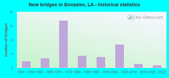
- New bridges - historical statistics
- 51950-1959
- 71960-1969
- 341970-1979
- 91980-1989
- 81990-1999
- 172000-2009
- 32010-2019
- 22020-2022
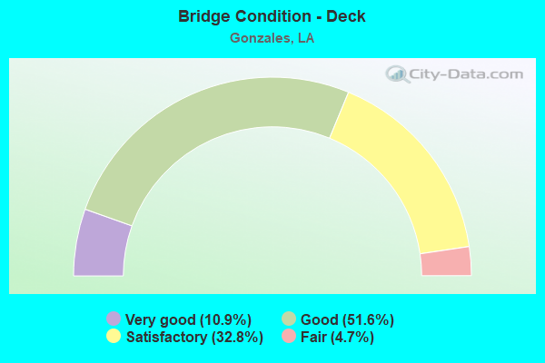
- Bridge Condition - Deck
- 10.9%Very good
- 51.6%Good
- 32.8%Satisfactory
- 4.7%Fair
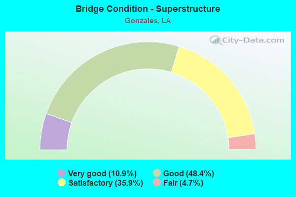
- Bridge Condition - Superstructure
- 10.9%Very good
- 48.4%Good
- 35.9%Satisfactory
- 4.7%Fair
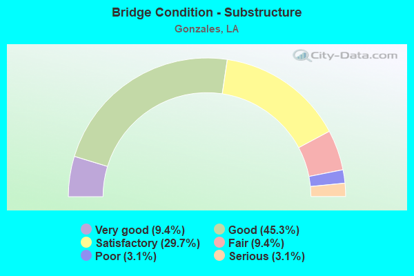
- Bridge Condition - Substructure
- 9.4%Very good
- 45.3%Good
- 29.7%Satisfactory
- 9.4%Fair
- 3.1%Poor
- 3.1%Serious
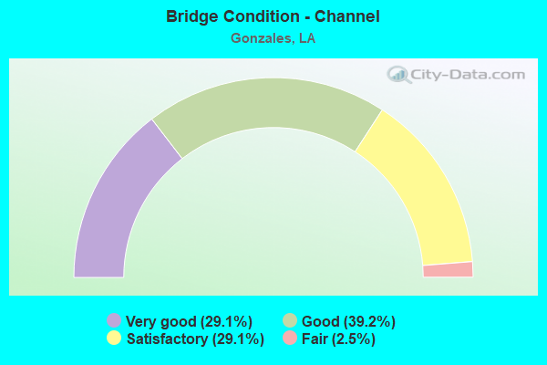
- Bridge Condition - Channel
- 29.1%Very good
- 39.2%Good
- 29.1%Satisfactory
- 2.5%Fair
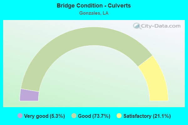
- Bridge Condition - Culverts
- 5.3%Very good
- 73.7%Good
- 21.1%Satisfactory
Find on map >> Show street view
Structure Number: 610330176905431, Location: 0.7 MI. SE OF LA 44 (Lat: 30.298981, Lng: -90.910389), Route carried "on" structure: County highway , Year Built: 2006, Status: Open, Structure Length: 1.07m (3.51ft), Average Daily Traffic: 250 (year 2019), Design Load: HS 20, Features Intersected: DRAIN BAYOU, Facility Carried by Structure: Merritt Evans Rd
Minimum Vertical Clearance: 30+ m (98+ ft), Kilometerpoint: 0.000, Lanes on structure: 2, Base Highway Network: Yes, Owner: County Highway Agency, Approaching Roadway Width: 5.5m (18.0ft), Skew: 3 degrees, Material/Design: Concrete, Design/Construction: Culvert, Number Of Spans In Main Unit: 2, Length of Maximum Span: 3.0m (9.8ft), Curb-To-Curb Width: 9.8m (32.2ft), Out-to-Out Width: 10.2m (33.5ft)
Condition: Channel: Good, Culverts: Very good, Operating Rating: 42.1 metric tons, Method Used To Determine Operating Rating: Load and Resistance Factor Rating (LRFR) rating reported by rating factor(RF) method using HL-93 loadings, Inventory Rating: 32.4 metric tons, Method Used To Determine Inventory Rating: Load and Resistance Factor Rating (LRFR) rating reported by rating factor(RF) method using HL-93 loadings, Structural Evaluation: Equal to present desirable criteria, Deck Geometry: Better than present minimum criteria, Waterway Adequacy: Equal to present desirable criteria, Approach Roadway Alignment: Equal to present desirable criteria, Designated Inspection Frequency: Every 24 months, Inspection Date: January 2021, Deck Structure Type: Concrete Cast-file-Place
Find on map >> Show street view
Structure Number: 610330181905111, Location: 0.1 MI SE OF ASCEN. 929 (Lat: 30.304461, Lng: -90.937139), Route carried "on" structure: County highway , Year Built: 1965, Status: Open, Structure Length: 0.70m (2.30ft), Average Daily Traffic: 20 (year 2019), Design Load: HS 20, Features Intersected: BLACK BAYOU, Facility Carried by Structure: Patty Jo Ln
Minimum Vertical Clearance: 30+ m (98+ ft), Kilometerpoint: 0.000, Lanes on structure: 1, Base Highway Network: Yes, Owner: County Highway Agency, Approaching Roadway Width: 4.6m (15.1ft), Material/Design: Concrete, Design/Construction: Culvert, Number Of Spans In Main Unit: 3, Length of Maximum Span: 2.4m (7.9ft), Curb-To-Curb Width: 5.8m (19.0ft), Out-to-Out Width: 7.6m (24.9ft)
Condition: Channel: Satisfactory, Culverts: Satisfactory, Operating Rating: 39.2 metric tons, Method Used To Determine Operating Rating: Load and Resistance Factor Rating (LRFR) rating reported by rating factor(RF) method using HL-93 loadings, Inventory Rating: 30.1 metric tons, Method Used To Determine Inventory Rating: Load and Resistance Factor Rating (LRFR) rating reported by rating factor(RF) method using HL-93 loadings, Structural Evaluation: Equal to present minimum criteria, Deck Geometry: Meets minimum limits, Waterway Adequacy: Better than present minimum criteria, Approach Roadway Alignment: Better than present minimum criteria, Designated Inspection Frequency: Every 24 months, Inspection Date: January 2021, Deck Structure Type: Concrete Cast-file-Place
Find on map >> Show street view
Structure Number: 610330313911141, Location: .08 MI S INTER CANNON RD (Lat: 30.262711, Lng: -90.912581), Route carried "on" structure: County highway , Year Built: 1977, Year Reconstructed: 2001, Status: Posted for load, Structure Length: 1.77m (5.81ft), Average Daily Traffic: 20 (year 2019), Design Load: HS 20, Features Intersected: BAYOU BLACK, Facility Carried by Structure: Ott Ln
Minimum Vertical Clearance: 30+ m (98+ ft), Kilometerpoint: 0.000, Lanes on structure: 2, Base Highway Network: Yes, Owner: County Highway Agency, Approaching Roadway Width: 7.3m (24.0ft), Material/Design: Concrete, Design/Construction: Slab, Number Of Spans In Main Unit: 2, Length of Maximum Span: 5.8m (19.0ft), Curb-To-Curb Width: 7.3m (24.0ft), Out-to-Out Width: 8.3m (27.2ft)
Condition: Deck: Fair, Superstructure: Fair, Substructure: Satisfactory, Channel: Good, Operating Rating: 24.3 metric tons, Method Used To Determine Operating Rating: Load and Resistance Factor Rating (LRFR) rating reported by rating factor(RF) method using HL-93 loadings, Inventory Rating: 18.8 metric tons, Method Used To Determine Inventory Rating: Load and Resistance Factor Rating (LRFR) rating reported by rating factor(RF) method using HL-93 loadings, Structural Evaluation: Somewhat better than minimum adequacy, Deck Geometry: Equal to present minimum criteria, Waterway Adequacy: Equal to present desirable criteria, Approach Roadway Alignment: Equal to present desirable criteria, Designated Inspection Frequency: Every 24 months, Inspection Date: January 2021, Deck Structure Type: Concrete Precast Panels, Wearing Surface/Protective System: Wearing Surface: Monolithic Concrete
Find on map >> Show street view
Structure Number: 610304501106811, Location: 1.1 MI. E. OF LA 73 (Lat: 30.240661, Lng: -90.969539), Route carried "under" structure: State highway 429, Year Built: 1957, Structure Length: 0. m, Average Daily Traffic: 6,587 (year 2021), Truck Traffic: 1%, Features Intersected: LA 429 UNDER I-10 E
Minimum Vertical Clearance: 4.72m (15.49ft), Kilometerpoint: 1.873, Lanes on structure: 2, Material/Design: Concrete, Design/Construction: Slab, Length of Maximum Span: 13.1m (43.0ft)
Find on map >> Show street view
Structure Number: 610304501106811, Location: 3.4 Mi W. of LA 44 (Lat: 30.240669, Lng: -90.969800), Route carried "under" structure: State highway 429, Structure Length: 0. m, Average Daily Traffic: 6,587 (year 2021), Features Intersected: I-10 East Bound
Minimum Vertical Clearance: 4.72m (15.49ft), Kilometerpoint: 6.703, Lanes on structure: 2, Length of Maximum Span: 13.1m (43.0ft)
Find on map >> Show street view
Structure Number: 610304501106812, Location: 1.1 MI. S. OF LA 73 (Lat: 30.240631, Lng: -90.970000), Route carried "under" structure: State highway 429, Year Built: 1957, Structure Length: 0. m, Average Daily Traffic: 4,300 (year 2015), Truck Traffic: 1%, Features Intersected: LA 429 UNDER I-10 E
Minimum Vertical Clearance: 4.69m (15.39ft), Kilometerpoint: 1.828, Lanes on structure: 2, Material/Design: Concrete, Design/Construction: Slab, Length of Maximum Span: 6.1m (20.0ft)
Find on map >> Show street view
Structure Number: 610304501109271, Location: 3.9 MI. W. OF US 61 (Lat: 30.210731, Lng: -90.947700), Route carried "under" structure: State highway 30, Structure Length: 0. m, Average Daily Traffic: 13,300 (year 2016), Features Intersected: LA 30 W. UNDER I-10 E.
Minimum Vertical Clearance: 5.24m (17.19ft), Kilometerpoint: 10.903, Lanes on structure: 2, Length of Maximum Span: 0.0m
Find on map >> Show street view
Structure Number: 610304501109271, Location: 3.9 MI. W. OF US 61 (Lat: 30.210589, Lng: -90.947781), Route carried "under" structure: State highway 30, Structure Length: 0. m, Average Daily Traffic: 9,200 (year 0000), Features Intersected: LA 30 E. UNDER I-10 E.
Minimum Vertical Clearance: 5.33m (17.49ft), Kilometerpoint: 6.294, Lanes on structure: 2, Length of Maximum Span: 0.0m
Find on map >> Show street view
Structure Number: 610304501109272, Location: 3.9 MI. W. OF US 61 (Lat: 30.210600, Lng: -90.946931), Route carried "under" structure: State highway 30, Structure Length: 0. m, Average Daily Traffic: 13,300 (year 2016), Features Intersected: LA 30 W. UNDER I-10 W.
Minimum Vertical Clearance: 5.33m (17.49ft), Kilometerpoint: 10.977, Lanes on structure: 2, Length of Maximum Span: 0.0m
Find on map >> Show street view
Structure Number: 610304501109272, Location: 3.9 MI. W. OF US 61 (Lat: 30.210781, Lng: -90.946919), Route carried "under" structure: State highway 30, Structure Length: 0. m, Average Daily Traffic: 9,200 (year 2016), Features Intersected: LA 30 E. UNDER I-10 W.
Minimum Vertical Clearance: 5.24m (17.19ft), Kilometerpoint: 6.299, Lanes on structure: 2, Length of Maximum Span: 0.0m
Find on map >> Show street view
Structure Number: 610304501111321, Location: 1.3 MI. E. OF LA 30 (Lat: 30.192169, Lng: -90.920300), Route carried "under" structure: State highway 44, Structure Length: 0. m, Average Daily Traffic: 13,700 (year 2015), Features Intersected: LA 44 E. UNDER I-10 E.
Minimum Vertical Clearance: 5.24m (17.19ft), Kilometerpoint: 6.016, Lanes on structure: 2, Length of Maximum Span: 0.0m
Find on map >> Show street view
Structure Number: 610304501111321, Location: 1.3 MI. E. OF LA 30 (Lat: 30.191939, Lng: -90.920089), Route carried "under" structure: State highway 44, Structure Length: 0. m, Average Daily Traffic: 13,700 (year 2015), Features Intersected: LA 44 W. UNDER I-10 E.
Minimum Vertical Clearance: 5.18m (16.99ft), Kilometerpoint: 6.104, Lanes on structure: 2, Length of Maximum Span: 0.0m
Find on map >> Show street view
Structure Number: 610304501111322, Location: 1.3 MI. E. OF LA 30 (Lat: 30.192889, Lng: -90.920311), Route carried "under" structure: State highway 44, Structure Length: 0. m, Average Daily Traffic: 13,700 (year 2015), Features Intersected: LA 44 E. UNDER I-10 W.
Minimum Vertical Clearance: 5.15m (16.90ft), Kilometerpoint: 5.937, Lanes on structure: 2, Length of Maximum Span: 0.0m
Find on map >> Show street view
Structure Number: 610304501111322, Location: 1.3 MI. E. OF LA 30 (Lat: 30.192650, Lng: -90.920100), Route carried "under" structure: State highway 44, Structure Length: 0. m, Average Daily Traffic: 13,700 (year 2015), Features Intersected: LA 44 W. UNDER I-10 W.
Minimum Vertical Clearance: 5.21m (17.09ft), Kilometerpoint: 6.181, Lanes on structure: 2, Length of Maximum Span: 0.0m