Bridge Statistics for Great Bend, Kansas (KS)
Condition, Traffic, Stress, Structural Evaluation, Project Costs
- National Bridge Inventory (NBI) Statistics
- 67Number of bridges
- 715ft / 218mTotal length
- $800,000Total costs
- 95,799Total average daily traffic
- 14,816Total average daily truck traffic
- 110,932Total future (year 2041) average daily traffic
- National Bridge Inventory (NBI) Registered Bridges for Great Bend
- No street view available for this location
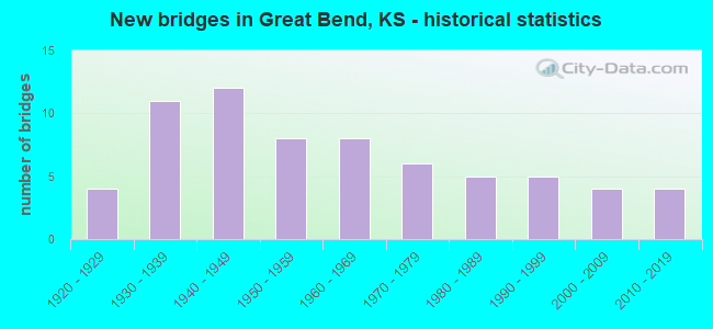
- New bridges - historical statistics
- 41920-1929
- 111930-1939
- 121940-1949
- 81950-1959
- 81960-1969
- 61970-1979
- 51980-1989
- 51990-1999
- 42000-2009
- 42010-2019
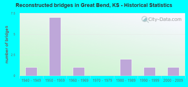
- Reconstructed bridges - Historical Statistics
- 11940-1949
- 71950-1959
- 11960-1969
- 01970-1979
- 21980-1989
- 11990-1999
- 12000-2009
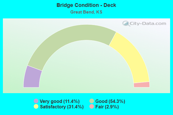
- Bridge Condition - Deck
- 11.4%Very good
- 54.3%Good
- 31.4%Satisfactory
- 2.9%Fair
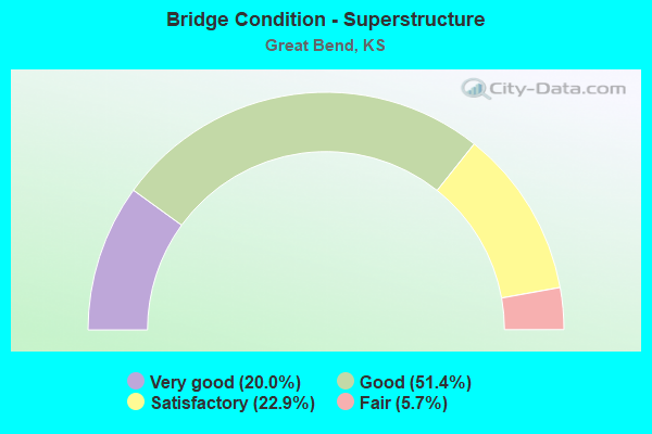
- Bridge Condition - Superstructure
- 20.0%Very good
- 51.4%Good
- 22.9%Satisfactory
- 5.7%Fair
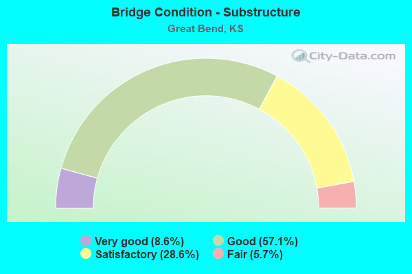
- Bridge Condition - Substructure
- 8.6%Very good
- 57.1%Good
- 28.6%Satisfactory
- 5.7%Fair
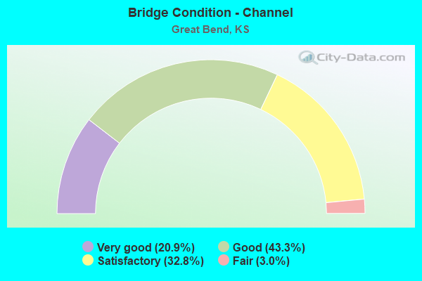
- Bridge Condition - Channel
- 20.9%Very good
- 43.3%Good
- 32.8%Satisfactory
- 3.0%Fair
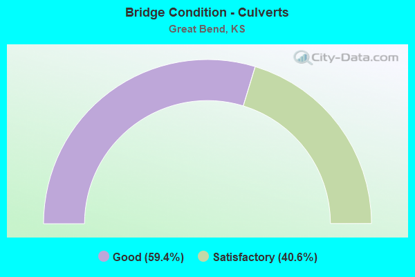
- Bridge Condition - Culverts
- 59.4%Good
- 40.6%Satisfactory
Find on map >> Show street view
Structure Number: 410900051614667, Location: 24TH. ST. AND FREY (Lat: 38.376361, Lng: -98.755861), Route carried "on" structure: City street 1614, Year Built: 1983, Status: Open, Structure Length: 1.25m (4.10ft), Average Daily Traffic: 650 (year 2018), Truck Traffic: 5%, Average Future Daily Traffic: 675 (year 2041), Design Load: HS 20, Features Intersected: LISCHESKY DRAINAGE DITCH, Facility Carried by Structure: 24TH. STREET
Minimum Vertical Clearance: 30.47m (99.97ft), Kilometerpoint: 0.000, Lanes on structure: 2, Owner: City or Municipal Highway Agency, Approaching Roadway Width: 12.4m (40.7ft), Material/Design: Concrete, Design/Construction: Culvert, Number Of Spans In Main Unit: 2, Length of Maximum Span: 6.1m (20.0ft), Curb or Sidewalk Widths: Left: 1.5m (4.9ft), Right: 1.5m (4.9ft), Curb-To-Curb Width: 12.5m (41.0ft), Out-to-Out Width: 16.2m (53.1ft)
Condition: Channel: Good, Culverts: Satisfactory, Operating Rating: 28.2 metric tons, Method Used To Determine Operating Rating: Load Factor (LF), Inventory Rating: 16.9 metric tons, Method Used To Determine Inventory Rating: Load Factor (LF), Structural Evaluation: Meets minimum limits, Deck Geometry: Superior to present desirable criteria, Waterway Adequacy: Better than present minimum criteria, Approach Roadway Alignment: Better than present minimum criteria, Designated Inspection Frequency: Every 24 months, Inspection Date: March 2021, Deck Structure Type: Concrete Cast-file-Place, Wearing Surface/Protective System: Wearing Surface: Monolithic Concrete
Find on map >> Show street view
Structure Number: 410900051615665, Location: 21ST. ST. AND FREY (Lat: 38.372556, Lng: -98.755806), Route carried "on" structure: City street 1615, Year Built: 1988, Status: Open, Structure Length: 1.25m (4.10ft), Average Daily Traffic: 600 (year 2018), Truck Traffic: 5%, Average Future Daily Traffic: 650 (year 2041), Design Load: HS 20, Features Intersected: LISCHESKY DRAINAGE DITCH, Facility Carried by Structure: FREY STREET
Minimum Vertical Clearance: 30.47m (99.97ft), Kilometerpoint: 0.000, Lanes on structure: 2, Owner: City or Municipal Highway Agency, Approaching Roadway Width: 6.7m (22.0ft), Material/Design: Concrete, Design/Construction: Culvert, Number Of Spans In Main Unit: 2, Length of Maximum Span: 6.1m (20.0ft), Curb-To-Curb Width: 9.1m (29.9ft), Out-to-Out Width: 9.8m (32.2ft)
Condition: Channel: Good, Culverts: Satisfactory, Operating Rating: 29.6 metric tons, Method Used To Determine Operating Rating: Load Factor (LF), Inventory Rating: 17.7 metric tons, Method Used To Determine Inventory Rating: Load Factor (LF), Structural Evaluation: Meets minimum limits, Deck Geometry: Equal to present minimum criteria, Waterway Adequacy: Better than present minimum criteria, Approach Roadway Alignment: Better than present minimum criteria, Designated Inspection Frequency: Every 24 months, Inspection Date: March 2021, Deck Structure Type: Concrete Cast-file-Place, Wearing Surface/Protective System: Wearing Surface: Monolithic Concrete
Find on map >> Show street view
Structure Number: 410900051617001, Location: 800 FT. N. OF 10TH. ST. (Lat: 38.363750, Lng: -98.752944), Route carried "on" structure: City street 1617, Year Built: 1949, Status: Open, Structure Length: 0.65m (2.13ft), Average Daily Traffic: 3,922 (year 2018), Truck Traffic: 10%, Average Future Daily Traffic: 4,707 (year 2041), Design Load: HS 20, Features Intersected: 11TH. ST. DRAINAGE DTCH., Facility Carried by Structure: 281 BYPASS
Minimum Vertical Clearance: 30.47m (99.97ft), Kilometerpoint: 0.000, Lanes on structure: 1, Owner: City or Municipal Highway Agency, Approaching Roadway Width: 9.7m (31.8ft), Skew: 2 degrees, Material/Design: Concrete, Design/Construction: Culvert, Number Of Spans In Main Unit: 2, Length of Maximum Span: 3.1m (10.2ft)
Condition: Channel: Satisfactory, Culverts: Satisfactory, Operating Rating: 32.6 metric tons, Method Used To Determine Operating Rating: Load Factor (LF), Inventory Rating: 19.5 metric tons, Method Used To Determine Inventory Rating: Load Factor (LF), Structural Evaluation: Somewhat better than minimum adequacy, Waterway Adequacy: Better than present minimum criteria, Approach Roadway Alignment: Better than present minimum criteria, Designated Inspection Frequency: Every 24 months, Inspection Date: March 2021, Deck Structure Type: Concrete Cast-file-Place, Wearing Surface/Protective System: Wearing Surface: Bituminous
Find on map >> Show street view
Structure Number: 510900050000001, Location: Rock Bridge Road (Lat: 38.379250, Lng: -98.798750), Route carried "on" structure: City street , Year Built: 1976, Status: Open, Structure Length: 0.62m (2.03ft), Average Daily Traffic: 205 (year 2018), Average Future Daily Traffic: 246 (year 2041), Design Load: HS 20, Features Intersected: DRAINAGE DITCH, Facility Carried by Structure: Rock Bridge Road
Minimum Vertical Clearance: 30.47m (99.97ft), Kilometerpoint: 0.000, Lanes on structure: 2, Owner: City or Municipal Highway Agency, Approaching Roadway Width: 9.1m (29.9ft), Material/Design: Concrete, Design/Construction: Culvert, Number Of Spans In Main Unit: 1, Length of Maximum Span: 6.2m (20.3ft), Curb or Sidewalk Widths: Left: 1.5m (4.9ft), Right: 1.5m (4.9ft), Curb-To-Curb Width: 9.1m (29.9ft), Out-to-Out Width: 13.4m (44.0ft)
Condition: Channel: Very good, Culverts: Good, Operating Rating: 43.2 metric tons, Method Used To Determine Operating Rating: Load Factor (LF), Inventory Rating: 25.4 metric tons, Method Used To Determine Inventory Rating: Load Factor (LF), Structural Evaluation: Equal to present minimum criteria, Deck Geometry: Equal to present minimum criteria, Waterway Adequacy: Equal to present desirable criteria, Approach Roadway Alignment: Better than present minimum criteria, Designated Inspection Frequency: Every 24 months, Underwater Inspection Frequency: Every 60 months, Inspection Date: March 2021, Underwater Inspection Date: September 2021, Wearing Surface/Protective System: Wearing Surface: Bituminous
Find on map >> Show street view
Structure Number: 999905600050041, Location: 0.57 MI E K156 (Lat: 38.364722, Lng: -98.685000), Route carried "on" structure: US 56, Year Built: 1931, Year Reconstructed: 1986, Status: Open, Structure Length: 1.34m (4.40ft), Average Daily Traffic: 4,429 (year 2020), Truck Traffic: 19%, Average Future Daily Traffic: 5,404 (year 2041), Design Load: H 15, Features Intersected: ARKANSAS RIVER DRAINAGE
Minimum Vertical Clearance: 30.47m (99.97ft), Kilometerpoint: 30.864, Lanes on structure: 2, Base Highway Network: Yes, Owner: State Highway Agency, Approaching Roadway Width: 13.4m (44.0ft), Material/Design: Concrete, Design/Construction: Culvert, Number Of Spans In Main Unit: 5, Length of Maximum Span: 2.4m (7.9ft), Curb-To-Curb Width: 13.5m (44.3ft), Out-to-Out Width: 14.1m (46.3ft)
Condition: Channel: Good, Culverts: Satisfactory, Operating Rating: 31.4 metric tons, Method Used To Determine Operating Rating: Load Factor (LF), Inventory Rating: 18.8 metric tons, Method Used To Determine Inventory Rating: Load Factor (LF), Structural Evaluation: Somewhat better than minimum adequacy, Deck Geometry: Superior to present desirable criteria, Waterway Adequacy: Better than present minimum criteria, Approach Roadway Alignment: Equal to present desirable criteria, Length Of Structure Improvement: 4.38m (14.37ft), Designated Inspection Frequency: Every 24 months, Inspection Date: September 2020, Deck Structure Type: Concrete Cast-file-Place, Wearing Surface/Protective System: Wearing Surface: Bituminous
Find on map >> Show street view
Structure Number: 999905600050771, Location: 1.82 MI E US281 ALT (Lat: 38.365000, Lng: -98.718056), Route carried "on" structure: US 56, Year Built: 1985, Status: Open, Structure Length: 3.43m (11.25ft), Average Daily Traffic: 8,093 (year 2020), Truck Traffic: 21%, Average Future Daily Traffic: 9,875 (year 2041), Design Load: HS 20, Features Intersected: WALNUT CR. DRAINAGE
Minimum Vertical Clearance: 30.47m (99.97ft), Kilometerpoint: 27.972, Lanes on structure: 2, Base Highway Network: Yes, Owner: State Highway Agency, Approaching Roadway Width: 13.4m (44.0ft), Material/Design: Concrete continuous, Design/Construction: Slab, Number Of Spans In Main Unit: 3, Length of Maximum Span: 13.4m (44.0ft), Curb-To-Curb Width: 13.4m (44.0ft), Out-to-Out Width: 14.0m (45.9ft)
Condition: Deck: Good, Superstructure: Good, Substructure: Very good, Channel: Good, Operating Rating: 64.4 metric tons, Method Used To Determine Operating Rating: Load Factor (LF), Inventory Rating: 38.1 metric tons, Method Used To Determine Inventory Rating: Load Factor (LF), Structural Evaluation: Better than present minimum criteria, Deck Geometry: Equal to present minimum criteria, Waterway Adequacy: Equal to present desirable criteria, Approach Roadway Alignment: Equal to present desirable criteria, Length Of Structure Improvement: 11.25m (36.91ft), Designated Inspection Frequency: Every 24 months, Inspection Date: September 2020, Wearing Surface/Protective System: Wearing Surface: Low Slump Concrete, Deck Protection: Epoxy Coated Reinforcing
Find on map >> Show street view
Structure Number: 999905600050781, Location: 2.13 MI E US281 ALT (Lat: 38.365000, Lng: -98.712500), Route carried "on" structure: US 56, Year Built: 1985, Status: Open, Structure Length: 5.26m (17.26ft), Average Daily Traffic: 8,093 (year 2020), Truck Traffic: 21%, Average Future Daily Traffic: 9,875 (year 2041), Design Load: HS 20, Features Intersected: WALNUT CREEK
Minimum Vertical Clearance: 30.47m (99.97ft), Kilometerpoint: 28.463, Lanes on structure: 2, Base Highway Network: Yes, Owner: State Highway Agency, Approaching Roadway Width: 13.4m (44.0ft), Material/Design: Steel continuous, Design/Construction: Stringer/Multi-beam, Number Of Spans In Main Unit: 3, Length of Maximum Span: 21.3m (69.9ft), Curb-To-Curb Width: 13.4m (44.0ft), Out-to-Out Width: 14.0m (45.9ft)
Condition: Deck: Good, Superstructure: Very good, Substructure: Good, Channel: Good, Operating Rating: 64.6 metric tons, Method Used To Determine Operating Rating: Load Factor (LF), Inventory Rating: 38.6 metric tons, Method Used To Determine Inventory Rating: Load Factor (LF), Structural Evaluation: Better than present minimum criteria, Deck Geometry: Equal to present minimum criteria, Waterway Adequacy: Equal to present minimum criteria, Approach Roadway Alignment: Equal to present desirable criteria, Length Of Structure Improvement: 17.25m (56.59ft), Designated Inspection Frequency: Every 24 months, Inspection Date: September 2020, Wearing Surface/Protective System: Wearing Surface: Low Slump Concrete, Deck Protection: Epoxy Coated Reinforcing
Find on map >> Show street view
Structure Number: 999905600050831, Location: 10.90 MI NE PAWNEE COLN (Lat: 38.343056, Lng: -98.817500), Route carried "on" structure: US 56, Year Built: 1992, Status: Open, Structure Length: 10.74m (35.24ft), Average Daily Traffic: 4,929 (year 2020), Truck Traffic: 20%, Average Future Daily Traffic: 5,781 (year 2041), Design Load: HS 20, Features Intersected: DIVRSION CL AND PED PASS
Minimum Vertical Clearance: 30.47m (99.97ft), Kilometerpoint: 17.457, Lanes on structure: 2, Base Highway Network: Yes, Owner: State Highway Agency, Approaching Roadway Width: 13.4m (44.0ft), Material/Design: Prestressed concrete continuous, Design/Construction: Stringer/Multi-beam, Number Of Spans In Main Unit: 5, Length of Maximum Span: 21.3m (69.9ft), Curb-To-Curb Width: 13.4m (44.0ft), Out-to-Out Width: 14.0m (45.9ft)
Condition: Deck: Good, Superstructure: Good, Substructure: Good, Channel: Very good, Operating Rating: 63.2 metric tons, Method Used To Determine Operating Rating: Load Factor (LF), Inventory Rating: 30.7 metric tons, Method Used To Determine Inventory Rating: Load Factor (LF), Structural Evaluation: Better than present minimum criteria, Deck Geometry: Better than present minimum criteria, Waterway Adequacy: Equal to present desirable criteria, Approach Roadway Alignment: Equal to present desirable criteria, Length Of Structure Improvement: 35.25m (115.65ft), Designated Inspection Frequency: Every 24 months, Inspection Date: October 2020, Wearing Surface/Protective System: Wearing Surface: Monolithic Concrete, Deck Protection: Epoxy Coated Reinforcing
Find on map >> Show street view
Structure Number: 999909600050561, Location: 8.88 MI E RUSH COLN (Lat: 38.417222, Lng: -98.879722), Route carried "on" structure: State highway 96, Year Built: 1946, Year Reconstructed: 1964, Status: Open, Structure Length: 1.65m (5.41ft), Average Daily Traffic: 2,286 (year 2020), Truck Traffic: 17%, Average Future Daily Traffic: 2,577 (year 2041), Design Load: H 15, Features Intersected: DRY WALNUT CREEK DR
Minimum Vertical Clearance: 30.47m (99.97ft), Kilometerpoint: 14.288, Lanes on structure: 2, Base Highway Network: Yes, Owner: State Highway Agency, Approaching Roadway Width: 9.1m (29.9ft), Material/Design: Concrete, Design/Construction: Culvert, Number Of Spans In Main Unit: 5, Length of Maximum Span: 3.0m (9.8ft), Curb-To-Curb Width: 13.4m (44.0ft), Out-to-Out Width: 14.2m (46.6ft)
Condition: Channel: Very good, Culverts: Good, Operating Rating: 28.2 metric tons, Method Used To Determine Operating Rating: Load Factor (LF), Inventory Rating: 16.9 metric tons, Method Used To Determine Inventory Rating: Load Factor (LF), Structural Evaluation: Meets minimum limits, Deck Geometry: Better than present minimum criteria, Waterway Adequacy: Equal to present desirable criteria, Approach Roadway Alignment: Better than present minimum criteria, Length Of Structure Improvement: 5.42m (17.78ft), Designated Inspection Frequency: Every 24 months, Inspection Date: October 2020, Deck Structure Type: Concrete Cast-file-Place, Wearing Surface/Protective System: Wearing Surface: Bituminous
Find on map >> Show street view
Structure Number: 999909600050571, Location: 9.42 MI E RUSH COLN (Lat: 38.413333, Lng: -98.871111), Route carried "on" structure: State highway 96, Year Built: 1946, Year Reconstructed: 1964, Status: Open, Structure Length: 0.78m (2.56ft), Average Daily Traffic: 2,286 (year 2020), Truck Traffic: 17%, Average Future Daily Traffic: 2,577 (year 2041), Design Load: H 15, Features Intersected: DRY WALNUT CREEK DR
Minimum Vertical Clearance: 30.47m (99.97ft), Kilometerpoint: 15.158, Lanes on structure: 2, Base Highway Network: Yes, Owner: State Highway Agency, Approaching Roadway Width: 9.1m (29.9ft), Material/Design: Concrete, Design/Construction: Culvert, Number Of Spans In Main Unit: 3, Length of Maximum Span: 2.4m (7.9ft), Curb-To-Curb Width: 13.4m (44.0ft), Out-to-Out Width: 14.2m (46.6ft)
Condition: Channel: Good, Culverts: Satisfactory, Operating Rating: 32.9 metric tons, Method Used To Determine Operating Rating: Load Factor (LF), Inventory Rating: 19.8 metric tons, Method Used To Determine Inventory Rating: Load Factor (LF), Structural Evaluation: Somewhat better than minimum adequacy, Deck Geometry: Better than present minimum criteria, Waterway Adequacy: Equal to present desirable criteria, Approach Roadway Alignment: Better than present minimum criteria, Length Of Structure Improvement: 2.55m (8.37ft), Designated Inspection Frequency: Every 24 months, Inspection Date: October 2020, Deck Structure Type: Concrete Cast-file-Place, Wearing Surface/Protective System: Wearing Surface: Bituminous
Find on map >> Show street view
Structure Number: 999909600050581, Location: 9.60 MI E RUSH COLN (Lat: 38.412222, Lng: -98.868056), Route carried "on" structure: State highway 96, Year Built: 1946, Year Reconstructed: 1964, Status: Open, Structure Length: 1.20m (3.94ft), Average Daily Traffic: 2,286 (year 2020), Truck Traffic: 17%, Average Future Daily Traffic: 2,577 (year 2041), Design Load: H 15, Features Intersected: DRY WALNUT CREEK DR
Minimum Vertical Clearance: 30.47m (99.97ft), Kilometerpoint: 15.453, Lanes on structure: 2, Base Highway Network: Yes, Owner: State Highway Agency, Approaching Roadway Width: 9.1m (29.9ft), Material/Design: Concrete, Design/Construction: Culvert, Number Of Spans In Main Unit: 4, Length of Maximum Span: 2.7m (8.9ft), Curb-To-Curb Width: 13.4m (44.0ft), Out-to-Out Width: 14.2m (46.6ft)
Condition: Channel: Very good, Culverts: Good, Operating Rating: 32.3 metric tons, Method Used To Determine Operating Rating: Load Factor (LF), Inventory Rating: 19.3 metric tons, Method Used To Determine Inventory Rating: Load Factor (LF), Structural Evaluation: Somewhat better than minimum adequacy, Deck Geometry: Better than present minimum criteria, Waterway Adequacy: Equal to present desirable criteria, Approach Roadway Alignment: Better than present minimum criteria, Length Of Structure Improvement: 3.92m (12.86ft), Designated Inspection Frequency: Every 24 months, Inspection Date: October 2020, Deck Structure Type: Concrete Cast-file-Place, Wearing Surface/Protective System: Wearing Surface: Bituminous
Find on map >> Show street view
Structure Number: 999909600050591, Location: 10.41 MI E RUSH COLN (Lat: 38.405000, Lng: -98.856111), Route carried "on" structure: State highway 96, Year Built: 1946, Year Reconstructed: 1964, Status: Open, Structure Length: 1.20m (3.94ft), Average Daily Traffic: 2,286 (year 2020), Truck Traffic: 17%, Average Future Daily Traffic: 2,577 (year 2041), Design Load: H 15, Features Intersected: DRY WALNUT CREEK DR
Minimum Vertical Clearance: 30.47m (99.97ft), Kilometerpoint: 16.748, Lanes on structure: 2, Base Highway Network: Yes, Owner: State Highway Agency, Approaching Roadway Width: 9.1m (29.9ft), Material/Design: Concrete, Design/Construction: Culvert, Number Of Spans In Main Unit: 4, Length of Maximum Span: 2.7m (8.9ft), Curb-To-Curb Width: 13.4m (44.0ft), Out-to-Out Width: 14.2m (46.6ft)
Condition: Channel: Very good, Culverts: Good, Operating Rating: 32.3 metric tons, Method Used To Determine Operating Rating: Load Factor (LF), Inventory Rating: 19.3 metric tons, Method Used To Determine Inventory Rating: Load Factor (LF), Structural Evaluation: Somewhat better than minimum adequacy, Deck Geometry: Better than present minimum criteria, Waterway Adequacy: Equal to present desirable criteria, Approach Roadway Alignment: Better than present minimum criteria, Length Of Structure Improvement: 3.92m (12.86ft), Designated Inspection Frequency: Every 24 months, Inspection Date: October 2020, Deck Structure Type: Concrete Cast-file-Place, Wearing Surface/Protective System: Wearing Surface: Bituminous
Find on map >> Show street view
Structure Number: 999909600050601, Location: 10.70 MI E RUSH COLN (Lat: 38.402500, Lng: -98.851944), Route carried "on" structure: State highway 96, Year Built: 1946, Year Reconstructed: 1964, Status: Open, Structure Length: 1.65m (5.41ft), Average Daily Traffic: 2,286 (year 2020), Truck Traffic: 17%, Average Future Daily Traffic: 2,577 (year 2041), Design Load: H 15, Features Intersected: DRY WALNUT CREEK DR
Minimum Vertical Clearance: 30.47m (99.97ft), Kilometerpoint: 17.220, Lanes on structure: 2, Base Highway Network: Yes, Owner: State Highway Agency, Approaching Roadway Width: 9.1m (29.9ft), Material/Design: Concrete, Design/Construction: Culvert, Number Of Spans In Main Unit: 5, Length of Maximum Span: 3.0m (9.8ft), Curb-To-Curb Width: 13.4m (44.0ft), Out-to-Out Width: 14.2m (46.6ft)
Condition: Channel: Very good, Culverts: Good, Operating Rating: 28.8 metric tons, Method Used To Determine Operating Rating: Load Factor (LF), Inventory Rating: 17.2 metric tons, Method Used To Determine Inventory Rating: Load Factor (LF), Structural Evaluation: Meets minimum limits, Deck Geometry: Better than present minimum criteria, Waterway Adequacy: Equal to present desirable criteria, Approach Roadway Alignment: Better than present minimum criteria, Length Of Structure Improvement: 5.42m (17.78ft), Designated Inspection Frequency: Every 24 months, Inspection Date: October 2020, Deck Structure Type: Concrete Cast-file-Place, Wearing Surface/Protective System: Wearing Surface: Bituminous
Find on map >> Show street view
Structure Number: 999909600050611, Location: 11.44 MI E RUSH COLN (Lat: 38.395833, Lng: -98.841111), Route carried "on" structure: State highway 96, Year Built: 1946, Year Reconstructed: 1964, Status: Open, Structure Length: 1.98m (6.50ft), Average Daily Traffic: 2,286 (year 2020), Truck Traffic: 17%, Average Future Daily Traffic: 2,577 (year 2041), Design Load: H 15, Features Intersected: DRY WALNUT CREEK DR
Minimum Vertical Clearance: 30.47m (99.97ft), Kilometerpoint: 18.404, Lanes on structure: 2, Base Highway Network: Yes, Owner: State Highway Agency, Approaching Roadway Width: 9.1m (29.9ft), Material/Design: Concrete, Design/Construction: Culvert, Number Of Spans In Main Unit: 6, Length of Maximum Span: 3.0m (9.8ft), Curb-To-Curb Width: 13.4m (44.0ft), Out-to-Out Width: 14.2m (46.6ft)
Condition: Channel: Good, Culverts: Good, Operating Rating: 28.9 metric tons, Method Used To Determine Operating Rating: Load Factor (LF), Inventory Rating: 17.3 metric tons, Method Used To Determine Inventory Rating: Load Factor (LF), Structural Evaluation: Meets minimum limits, Deck Geometry: Better than present minimum criteria, Waterway Adequacy: Equal to present desirable criteria, Approach Roadway Alignment: Better than present minimum criteria, Length Of Structure Improvement: 6.50m (21.33ft), Designated Inspection Frequency: Every 24 months, Inspection Date: October 2020, Deck Structure Type: Concrete Cast-file-Place, Wearing Surface/Protective System: Wearing Surface: Bituminous
Find on map >> Show street view
Structure Number: 999909600050621, Location: 12.66 MI E RUSH COLN (Lat: 38.385278, Lng: -98.823333), Route carried "on" structure: State highway 96, Year Built: 1946, Year Reconstructed: 1964, Status: Open, Structure Length: 1.32m (4.33ft), Average Daily Traffic: 3,042 (year 2020), Truck Traffic: 12%, Average Future Daily Traffic: 3,429 (year 2041), Design Load: H 15, Features Intersected: LITTLE WALNUT CREEK DRG.
Minimum Vertical Clearance: 30.47m (99.97ft), Kilometerpoint: 20.376, Lanes on structure: 2, Base Highway Network: Yes, Owner: State Highway Agency, Approaching Roadway Width: 9.1m (29.9ft), Material/Design: Concrete, Design/Construction: Culvert, Number Of Spans In Main Unit: 4, Length of Maximum Span: 3.0m (9.8ft), Curb-To-Curb Width: 13.4m (44.0ft), Out-to-Out Width: 14.2m (46.6ft)
Condition: Channel: Very good, Culverts: Good, Operating Rating: 31.0 metric tons, Method Used To Determine Operating Rating: Load Factor (LF), Inventory Rating: 18.6 metric tons, Method Used To Determine Inventory Rating: Load Factor (LF), Structural Evaluation: Somewhat better than minimum adequacy, Deck Geometry: Better than present minimum criteria, Waterway Adequacy: Equal to present desirable criteria, Approach Roadway Alignment: Better than present minimum criteria, Length Of Structure Improvement: 4.33m (14.21ft), Designated Inspection Frequency: Every 24 months, Inspection Date: October 2020, Deck Structure Type: Concrete Cast-file-Place, Wearing Surface/Protective System: Wearing Surface: Bituminous
Find on map >> Show street view
Structure Number: 999909600050631, Location: 13.19 MI E RUSH COLN (Lat: 38.380000, Lng: -98.816667), Route carried "on" structure: State highway 96, Year Built: 1947, Year Reconstructed: 1994, Status: Open, Structure Length: 5.66m (18.57ft), Average Daily Traffic: 3,042 (year 2020), Truck Traffic: 12%, Average Future Daily Traffic: 3,429 (year 2041), Design Load: H 15, Features Intersected: LITTLE WALNUT CREEK
Minimum Vertical Clearance: 30.47m (99.97ft), Kilometerpoint: 21.210, Lanes on structure: 2, Base Highway Network: Yes, Owner: State Highway Agency, Approaching Roadway Width: 9.1m (29.9ft), Material/Design: Steel continuous, Design/Construction: Stringer/Multi-beam, Number Of Spans In Main Unit: 3, Length of Maximum Span: 19.8m (65.0ft), Curb-To-Curb Width: 13.4m (44.0ft), Out-to-Out Width: 14.0m (45.9ft)
Condition: Deck: Good, Superstructure: Good, Substructure: Good, Channel: Very good, Operating Rating: 57.5 metric tons, Method Used To Determine Operating Rating: Load Factor (LF), Inventory Rating: 34.5 metric tons, Method Used To Determine Inventory Rating: Load Factor (LF), Structural Evaluation: Better than present minimum criteria, Deck Geometry: Better than present minimum criteria, Waterway Adequacy: Equal to present minimum criteria, Approach Roadway Alignment: Better than present minimum criteria, Length Of Structure Improvement: 18.58m (60.96ft), Designated Inspection Frequency: Every 24 months, Inspection Date: October 2020, Wearing Surface/Protective System: Wearing Surface: Monolithic Concrete, Deck Protection: Epoxy Coated Reinforcing
Find on map >> Show street view
Structure Number: 999909600050821, Location: 11.12 MI E RUSH COLN (Lat: 38.398611, Lng: -98.845833), Route carried "on" structure: State highway 96, Year Built: 1992, Status: Open, Structure Length: 10.74m (35.24ft), Average Daily Traffic: 2,286 (year 2020), Truck Traffic: 17%, Average Future Daily Traffic: 2,577 (year 2041), Design Load: HS 20, Features Intersected: DIVERSION CHANNEL
Minimum Vertical Clearance: 30.47m (99.97ft), Kilometerpoint: 17.881, Lanes on structure: 2, Base Highway Network: Yes, Owner: State Highway Agency, Approaching Roadway Width: 9.1m (29.9ft), Material/Design: Prestressed concrete continuous, Design/Construction: Stringer/Multi-beam, Number Of Spans In Main Unit: 5, Length of Maximum Span: 21.3m (69.9ft), Curb-To-Curb Width: 13.4m (44.0ft), Out-to-Out Width: 14.0m (45.9ft)
Condition: Deck: Good, Superstructure: Very good, Substructure: Good, Channel: Very good, Operating Rating: 63.2 metric tons, Method Used To Determine Operating Rating: Load Factor (LF), Inventory Rating: 30.7 metric tons, Method Used To Determine Inventory Rating: Load Factor (LF), Structural Evaluation: Better than present minimum criteria, Deck Geometry: Better than present minimum criteria, Waterway Adequacy: Equal to present desirable criteria, Approach Roadway Alignment: Better than present minimum criteria, Length Of Structure Improvement: 35.25m (115.65ft), Designated Inspection Frequency: Every 24 months, Inspection Date: October 2020, Wearing Surface/Protective System: Wearing Surface: Monolithic Concrete, Deck Protection: Epoxy Coated Reinforcing
Find on map >> Show street view
Structure Number: 999915600050061, Location: 0.29 MI NE US56 (Lat: 38.368333, Lng: -98.693056), Route carried "on" structure: State highway 156, Year Built: 1962, Year Reconstructed: 2000, Status: Open, Structure Length: 1.30m (4.27ft), Average Daily Traffic: 2,888 (year 2020), Truck Traffic: 33%, Average Future Daily Traffic: 3,666 (year 2041), Design Load: H 20, Features Intersected: ARKANSAS RIVER DRAINAGE
Minimum Vertical Clearance: 30.47m (99.97ft), Kilometerpoint: 30.404, Lanes on structure: 2, Base Highway Network: Yes, Owner: State Highway Agency, Approaching Roadway Width: 13.4m (44.0ft), Material/Design: Concrete, Design/Construction: Culvert, Number Of Spans In Main Unit: 4, Length of Maximum Span: 3.0m (9.8ft), Curb-To-Curb Width: 13.4m (44.0ft), Out-to-Out Width: 25.5m (83.7ft)
Condition: Channel: Very good, Culverts: Good, Operating Rating: 32.0 metric tons, Method Used To Determine Operating Rating: Load Factor (LF), Inventory Rating: 19.1 metric tons, Method Used To Determine Inventory Rating: Load Factor (LF), Structural Evaluation: Somewhat better than minimum adequacy, Deck Geometry: Better than present minimum criteria, Waterway Adequacy: Equal to present desirable criteria, Approach Roadway Alignment: Somewhat better than minimum adequacy, Length Of Structure Improvement: 4.27m (14.01ft), Designated Inspection Frequency: Every 24 months, Inspection Date: September 2020, Deck Structure Type: Concrete Cast-file-Place, Wearing Surface/Protective System: Wearing Surface: Bituminous
Find on map >> Show street view
Structure Number: 999915600050071, Location: 1.17 MI NE US56 (Lat: 38.379444, Lng: -98.685000), Route carried "on" structure: State highway 156, Year Built: 1962, Status: Open, Structure Length: 4.34m (14.24ft), Average Daily Traffic: 2,888 (year 2020), Truck Traffic: 33%, Average Future Daily Traffic: 3,666 (year 2041), Design Load: H 20, Features Intersected: WALNUT CREEK DRAINAGE
Minimum Vertical Clearance: 30.47m (99.97ft), Kilometerpoint: 31.831, Lanes on structure: 2, Base Highway Network: Yes, Owner: State Highway Agency, Approaching Roadway Width: 13.4m (44.0ft), Material/Design: Concrete continuous, Design/Construction: Slab, Number Of Spans In Main Unit: 4, Length of Maximum Span: 12.2m (40.0ft), Curb-To-Curb Width: 13.4m (44.0ft), Out-to-Out Width: 14.0m (45.9ft)
Condition: Deck: Good, Superstructure: Good, Substructure: Good, Channel: Very good, Operating Rating: 50.8 metric tons, Method Used To Determine Operating Rating: Load Factor (LF), Inventory Rating: 29.9 metric tons, Method Used To Determine Inventory Rating: Load Factor (LF), Structural Evaluation: Better than present minimum criteria, Deck Geometry: Better than present minimum criteria, Waterway Adequacy: Equal to present desirable criteria, Approach Roadway Alignment: Equal to present desirable criteria, Length Of Structure Improvement: 14.25m (46.75ft), Designated Inspection Frequency: Every 24 months, Inspection Date: September 2020, Deck Structure Type: Concrete Cast-file-Place, Wearing Surface/Protective System: Wearing Surface: Low Slump Concrete
Find on map >> Show street view
Structure Number: 999928100050141, Location: 1.26 MI N US56/K156/K96 (Lat: 38.379444, Lng: -98.765000), Route carried "on" structure: US 281, Year Built: 1920, Year Reconstructed: 1949, Status: Open, Structure Length: 0.78m (2.56ft), Average Daily Traffic: 5,878 (year 2020), Truck Traffic: 10%, Average Future Daily Traffic: 6,118 (year 2041), Design Load: H 15, Features Intersected: LITTLE WALNUT CREEK DRG
Minimum Vertical Clearance: 30.47m (99.97ft), Kilometerpoint: 13.602, Lanes on structure: 2, Owner: State Highway Agency, Approaching Roadway Width: 11.0m (36.1ft), Material/Design: Concrete, Design/Construction: Culvert, Number Of Spans In Main Unit: 3, Length of Maximum Span: 2.4m (7.9ft), Curb-To-Curb Width: 12.2m (40.0ft), Out-to-Out Width: 13.0m (42.7ft)
Condition: Channel: Good, Culverts: Good, Operating Rating: 33.2 metric tons, Method Used To Determine Operating Rating: Load Factor (LF), Inventory Rating: 19.9 metric tons, Method Used To Determine Inventory Rating: Load Factor (LF), Structural Evaluation: Somewhat better than minimum adequacy, Deck Geometry: Somewhat better than minimum adequacy, Waterway Adequacy: Equal to present desirable criteria, Approach Roadway Alignment: Meets minimum limits, Length Of Structure Improvement: 2.55m (8.37ft), Designated Inspection Frequency: Every 24 months, Inspection Date: September 2020, Deck Structure Type: Concrete Cast-file-Place, Wearing Surface/Protective System: Wearing Surface: Monolithic Concrete
Find on map >> Show street view
Structure Number: 999928100050171, Location: 3.82 MI N US56/K156/K96 (Lat: 38.415833, Lng: -98.771111), Route carried "on" structure: US 281, Year Built: 1950, Status: Open, Structure Length: 1.32m (4.33ft), Average Daily Traffic: 3,730 (year 2020), Truck Traffic: 11%, Average Future Daily Traffic: 4,374 (year 2041), Design Load: H 20, Features Intersected: WALNUT CREEK DRAINAGE
Minimum Vertical Clearance: 30.47m (99.97ft), Kilometerpoint: 17.709, Lanes on structure: 2, Base Highway Network: Yes, Owner: State Highway Agency, Approaching Roadway Width: 11.0m (36.1ft), Material/Design: Concrete, Design/Construction: Culvert, Number Of Spans In Main Unit: 4, Length of Maximum Span: 3.0m (9.8ft), Curb-To-Curb Width: 13.4m (44.0ft), Out-to-Out Width: 13.4m (44.0ft)
Condition: Channel: Good, Culverts: Good, Operating Rating: 30.1 metric tons, Method Used To Determine Operating Rating: Load Factor (LF), Inventory Rating: 18.1 metric tons, Method Used To Determine Inventory Rating: Load Factor (LF), Structural Evaluation: Somewhat better than minimum adequacy, Deck Geometry: Better than present minimum criteria, Waterway Adequacy: Equal to present desirable criteria, Approach Roadway Alignment: Better than present minimum criteria, Length Of Structure Improvement: 4.33m (14.21ft), Designated Inspection Frequency: Every 24 months, Inspection Date: September 2020, Deck Structure Type: Concrete Cast-file-Place, Wearing Surface/Protective System: Wearing Surface: Bituminous
Find on map >> Show street view
Structure Number: 999928100050181, Location: 4.14 MI N US56/K156/K96 (Lat: 38.420278, Lng: -98.771944), Route carried "on" structure: US 281, Year Built: 1950, Status: Open, Structure Length: 6.16m (20.21ft), Average Daily Traffic: 3,730 (year 2020), Truck Traffic: 11%, Average Future Daily Traffic: 4,374 (year 2041), Design Load: H 20, Features Intersected: WALNUT CREEK
Minimum Vertical Clearance: 30.47m (99.97ft), Kilometerpoint: 18.234, Lanes on structure: 2, Base Highway Network: Yes, Owner: State Highway Agency, Approaching Roadway Width: 13.4m (44.0ft), Material/Design: Concrete continuous, Design/Construction: Tee Beam, Number Of Spans In Main Unit: 5, Length of Maximum Span: 13.7m (44.9ft), Curb-To-Curb Width: 7.9m (25.9ft), Out-to-Out Width: 8.3m (27.2ft)
Condition: Deck: Satisfactory, Superstructure: Satisfactory, Substructure: Good, Channel: Good, Operating Rating: 50.1 metric tons, Method Used To Determine Operating Rating: Load Factor (LF), Inventory Rating: 30.1 metric tons, Method Used To Determine Inventory Rating: Load Factor (LF), Structural Evaluation: Equal to present minimum criteria, Deck Geometry: High priority of corrective action, Waterway Adequacy: Equal to present minimum criteria, Approach Roadway Alignment: Equal to present minimum criteria, Length Of Structure Improvement: 20.21m (66.31ft), Designated Inspection Frequency: Every 24 months, Inspection Date: September 2020, Deck Structure Type: Concrete Cast-file-Place, Wearing Surface/Protective System: Wearing Surface: Low Slump Concrete
Find on map >> Show street view
Structure Number: 999928100050711, Location: 0.65 MI S US56 (Lat: 38.351944, Lng: -98.765000), Route carried "on" structure: US 281, Year Built: 1977, Status: Open, Structure Length: 24.95m (81.86ft), Average Daily Traffic: 6,458 (year 2020), Truck Traffic: 10%, Average Future Daily Traffic: 6,857 (year 2041), Design Load: HS 20, Features Intersected: ARKANSAS RIVER
Minimum Vertical Clearance: 30.47m (99.97ft), Kilometerpoint: 10.525, Lanes on structure: 4, Base Highway Network: Yes, Owner: State Highway Agency, Approaching Roadway Width: 15.7m (51.5ft), Skew: 2 degrees, Material/Design: Concrete continuous, Design/Construction: Tee Beam, Number Of Spans In Main Unit: 16, Length of Maximum Span: 21.6m (70.9ft), Curb or Sidewalk Widths: Left: 1.2m (3.9ft), Right: 1.2m (3.9ft), Curb-To-Curb Width: 15.7m (51.5ft), Out-to-Out Width: 20.1m (65.9ft)
Condition: Deck: Very good, Superstructure: Good, Substructure: Satisfactory, Channel: Satisfactory, Operating Rating: 47.2 metric tons, Method Used To Determine Operating Rating: Load Factor (LF), Inventory Rating: 28.1 metric tons, Method Used To Determine Inventory Rating: Load Factor (LF), Structural Evaluation: Equal to present minimum criteria, Deck Geometry: Meets minimum limits, Waterway Adequacy: Equal to present minimum criteria, Approach Roadway Alignment: Meets minimum limits, Length Of Structure Improvement: 81.84m (268.50ft), Designated Inspection Frequency: Every 24 months, Inspection Date: September 2020, Deck Structure Type: Concrete Cast-file-Place, Wearing Surface/Protective System: Wearing Surface: Epoxy Overlay
Find on map >> Show street view
Structure Number: 999928100051001, Location: 1.52 MI N US56/K156/K96 (Lat: 38.383333, Lng: -98.765278), Route carried "on" structure: US 281, Year Built: 2014, Status: Open, Structure Length: 4.34m (14.24ft), Average Daily Traffic: 5,033 (year 2020), Truck Traffic: 8%, Average Future Daily Traffic: 5,238 (year 2041), Design Load: HL 93, Features Intersected: DRY WALNUT CREEK
Minimum Vertical Clearance: 30.47m (99.97ft), Kilometerpoint: 14.021, Lanes on structure: 2, Owner: State Highway Agency, Approaching Roadway Width: 13.4m (44.0ft), Material/Design: Concrete continuous, Design/Construction: Slab, Number Of Spans In Main Unit: 3, Length of Maximum Span: 17.1m (56.1ft), Curb-To-Curb Width: 13.4m (44.0ft), Out-to-Out Width: 14.0m (45.9ft)
Condition: Deck: Very good, Superstructure: Very good, Substructure: Very good, Channel: Very good, Operating Rating: 65.4 metric tons, Method Used To Determine Operating Rating: Load and Resistance Factor Rating (LRFR) rating reported by rating factor(RF) method using HL-93 loadings, Inventory Rating: 50.5 metric tons, Method Used To Determine Inventory Rating: Load and Resistance Factor Rating (LRFR) rating reported by rating factor(RF) method using HL-93 loadings, Structural Evaluation: Equal to present desirable criteria, Deck Geometry: Equal to present minimum criteria, Waterway Adequacy: Equal to present desirable criteria, Approach Roadway Alignment: Meets minimum limits, Length Of Structure Improvement: 14.25m (46.75ft), Designated Inspection Frequency: Every 24 months, Inspection Date: September 2020, Wearing Surface/Protective System: Wearing Surface: Monolithic Concrete, Deck Protection: Epoxy Coated Reinforcing
Find on map >> Show street view
Structure Number: 999990000050934, Location: CHEYENNE BOTTOMS W.A. (Lat: 38.419167, Lng: -98.765000), Route carried "on" structure: ServiceCounty highway 560, Year Built: 1965, Status: Open, Structure Length: 0.88m (2.89ft), Average Daily Traffic: 29 (year 2020), Average Future Daily Traffic: 14 (year 2041), Features Intersected: Walnut Creek, Facility Carried by Structure: K900 PARKS ROUTE
Minimum Vertical Clearance: 30.47m (99.97ft), Kilometerpoint: 0.837, Lanes on structure: 2, Owner: State Park, Forest, or Reservation Agency, Maintenance Responsibility: State Highway Agency, Approaching Roadway Width: 8.5m (27.9ft), Material/Design: Concrete, Design/Construction: Culvert, Number Of Spans In Main Unit: 3, Length of Maximum Span: 2.7m (8.9ft), Curb-To-Curb Width: 6.4m (21.0ft), Out-to-Out Width: 7.2m (23.6ft)
Condition: Channel: Good, Culverts: Good, Operating Rating: 55.3 metric tons, Method Used To Determine Operating Rating: Load Factor (LF), Inventory Rating: 32.7 metric tons, Method Used To Determine Inventory Rating: Load Factor (LF), Structural Evaluation: Better than present minimum criteria, Deck Geometry: Somewhat better than minimum adequacy, Waterway Adequacy: Better than present minimum criteria, Approach Roadway Alignment: Somewhat better than minimum adequacy, Length Of Structure Improvement: 2.90m (9.51ft), Designated Inspection Frequency: Every 24 months, Inspection Date: September 2020, Deck Structure Type: Concrete Cast-file-Place, Wearing Surface/Protective System: Wearing Surface: Gravel