Bridge Statistics for Hays, Kansas (KS)
Condition, Traffic, Stress, Structural Evaluation, Project Costs
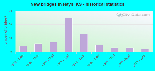
- New bridges - historical statistics
- 41930-1939
- 61940-1949
- 71950-1959
- 251960-1969
- 131970-1979
- 51980-1989
- 31990-1999
- 32000-2009
- 22010-2019
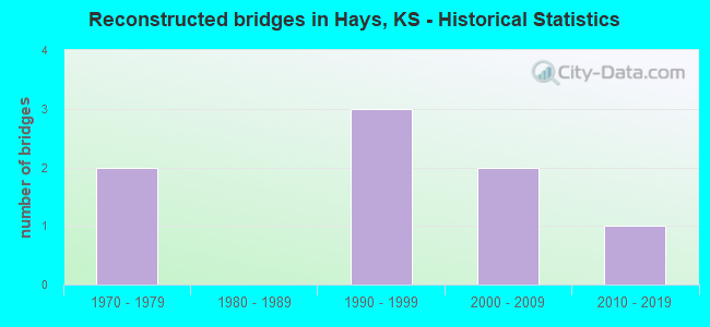
- Reconstructed bridges - Historical Statistics
- 21970-1979
- 01980-1989
- 31990-1999
- 22000-2009
- 12010-2019
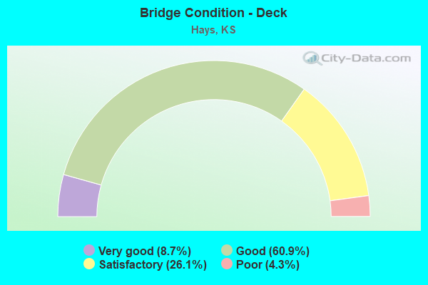
- Bridge Condition - Deck
- 8.7%Very good
- 60.9%Good
- 26.1%Satisfactory
- 4.3%Poor
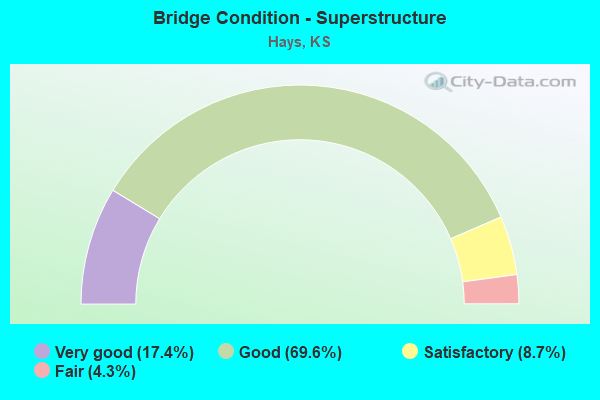
- Bridge Condition - Superstructure
- 17.4%Very good
- 69.6%Good
- 8.7%Satisfactory
- 4.3%Fair
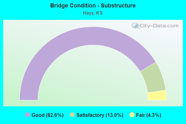
- Bridge Condition - Substructure
- 82.6%Good
- 13.0%Satisfactory
- 4.3%Fair
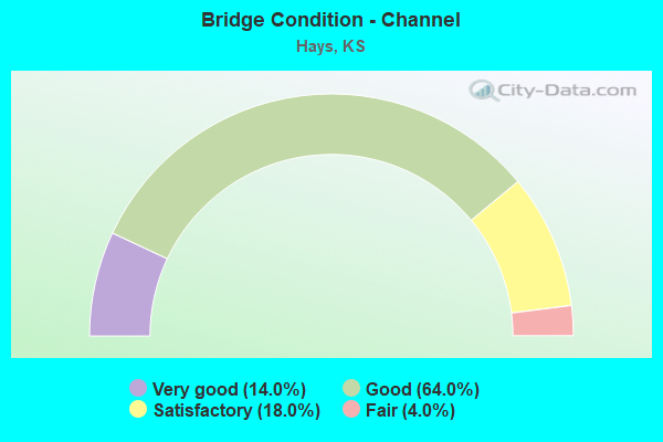
- Bridge Condition - Channel
- 14.0%Very good
- 64.0%Good
- 18.0%Satisfactory
- 4.0%Fair
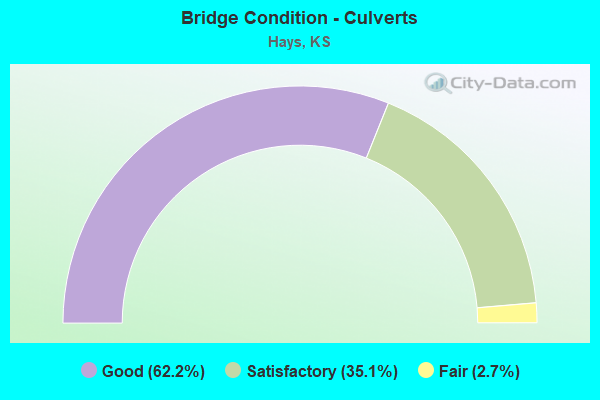
- Bridge Condition - Culverts
- 62.2%Good
- 35.1%Satisfactory
- 2.7%Fair
Find on map >> Show street view
Structure Number: 260595, Location: E. 27th Street (Lat: 38.885556, Lng: -99.295000), Route carried "on" structure: County highway 234, Year Built: 1965, Status: Open, Structure Length: 0.96m (3.15ft), Average Daily Traffic: 2,000 (year 2014), Truck Traffic: 10%, Average Future Daily Traffic: 2,200 (year 2040), Design Load: H 15, Features Intersected: STREAM, Facility Carried by Structure: E. 27th Street
Minimum Vertical Clearance: 30.47m (99.97ft), Kilometerpoint: 0.000, Lanes on structure: 2, Owner: County Highway Agency, Approaching Roadway Width: 6.7m (22.0ft), Material/Design: Concrete, Design/Construction: Culvert, Number Of Spans In Main Unit: 3, Length of Maximum Span: 3.0m (9.8ft), Curb-To-Curb Width: 9.8m (32.2ft), Out-to-Out Width: 10.4m (34.1ft)
Condition: Channel: Good, Culverts: Satisfactory, Operating Rating: 41.7 metric tons, Method Used To Determine Operating Rating: Load Factor (LF), Inventory Rating: 24.9 metric tons, Method Used To Determine Inventory Rating: Load Factor (LF), Structural Evaluation: Equal to present minimum criteria, Deck Geometry: Somewhat better than minimum adequacy, Waterway Adequacy: Better than present minimum criteria, Approach Roadway Alignment: Equal to present desirable criteria, Designated Inspection Frequency: Every 24 months, Inspection Date: December 2020, Wearing Surface/Protective System: Wearing Surface: Bituminous
Find on map >> Show street view
Structure Number: 26066, Location: 0.3S 4.5E OF HAYS (Lat: 38.874100, Lng: -99.243833), Route carried "on" structure: County highway 1877, Year Built: 1979, Status: Open, Structure Length: 0.98m (3.22ft), Average Daily Traffic: 725 (year 2014), Truck Traffic: 10%, Average Future Daily Traffic: 870 (year 2040), Design Load: H 20, Features Intersected: BIG CREEK TRIBUTARY, Facility Carried by Structure: Toulon Avenue
Minimum Vertical Clearance: 30.47m (99.97ft), Kilometerpoint: 0.000, Lanes on structure: 2, Owner: County Highway Agency, Approaching Roadway Width: 7.3m (24.0ft), Material/Design: Concrete, Design/Construction: Culvert, Number Of Spans In Main Unit: 3, Length of Maximum Span: 3.0m (9.8ft), Curb-To-Curb Width: 10.4m (34.1ft), Out-to-Out Width: 10.8m (35.4ft)
Condition: Channel: Good, Culverts: Satisfactory, Operating Rating: 24.3 metric tons, Method Used To Determine Operating Rating: Allowable Stress (AS), Inventory Rating: 19.8 metric tons, Method Used To Determine Inventory Rating: Allowable Stress (AS), Structural Evaluation: Somewhat better than minimum adequacy, Deck Geometry: Equal to present minimum criteria, Waterway Adequacy: Equal to present minimum criteria, Approach Roadway Alignment: Equal to present desirable criteria, Designated Inspection Frequency: Every 24 months, Inspection Date: December 2020, Wearing Surface/Protective System: Wearing Surface: Bituminous
Find on map >> Show street view
Structure Number: 26067, Location: 1.4S 2.0E OF HAYS (Lat: 38.857778, Lng: -99.290278), Route carried "on" structure: County highway 1910, Year Built: 1931, Status: Open, Structure Length: 1.04m (3.41ft), Average Daily Traffic: 3,695 (year 2014), Truck Traffic: 10%, Average Future Daily Traffic: 3,800 (year 2040), Design Load: H 15, Features Intersected: BIG CREEK TRIBUTARY, Facility Carried by Structure: Old Highway 40
Minimum Vertical Clearance: 30.47m (99.97ft), Kilometerpoint: 0.000, Lanes on structure: 2, Owner: County Highway Agency, Approaching Roadway Width: 7.3m (24.0ft), Material/Design: Concrete, Design/Construction: Culvert, Number Of Spans In Main Unit: 3, Length of Maximum Span: 3.0m (9.8ft), Curb-To-Curb Width: 8.2m (26.9ft), Out-to-Out Width: 9.0m (29.5ft)
Condition: Channel: Good, Culverts: Good, Operating Rating: 24.3 metric tons, Method Used To Determine Operating Rating: Allowable Stress (AS), Inventory Rating: 19.8 metric tons, Method Used To Determine Inventory Rating: Allowable Stress (AS), Structural Evaluation: Somewhat better than minimum adequacy, Deck Geometry: High priority of corrective action, Waterway Adequacy: Equal to present minimum criteria, Approach Roadway Alignment: Equal to present desirable criteria, Length Of Structure Improvement: 1.22m (4.00ft), Designated Inspection Frequency: Every 24 months, Inspection Date: December 2020, Bridge Improvement Cost: $162,000, Roadway Improvement Cost: $18,000, Total Project Cost: $180,000 ( Estimate for 2016), Wearing Surface/Protective System: Wearing Surface: Bituminous
Find on map >> Show street view
Structure Number: 26068, Location: 1.7S 4.0E OF HAYS (Lat: 38.852222, Lng: -99.247222), Route carried "on" structure: County highway 1910, Year Built: 1931, Status: Posted for load, Structure Length: 1.37m (4.49ft), Average Daily Traffic: 3,070 (year 2014), Truck Traffic: 10%, Average Future Daily Traffic: 3,200 (year 2040), Design Load: H 15, Features Intersected: BIG CREEK TRIBUTARY, Facility Carried by Structure: Old Highway 40
Minimum Vertical Clearance: 30.47m (99.97ft), Kilometerpoint: 0.000, Lanes on structure: 2, Owner: County Highway Agency, Approaching Roadway Width: 7.3m (24.0ft), Material/Design: Concrete, Design/Construction: Culvert, Number Of Spans In Main Unit: 4, Length of Maximum Span: 3.0m (9.8ft), Curb-To-Curb Width: 8.2m (26.9ft), Out-to-Out Width: 9.0m (29.5ft)
Condition: Channel: Good, Culverts: Fair, Operating Rating: 19.8 metric tons, Method Used To Determine Operating Rating: Allowable Stress (AS), Inventory Rating: 18.0 metric tons, Method Used To Determine Inventory Rating: Allowable Stress (AS), Structural Evaluation: Somewhat better than minimum adequacy, Deck Geometry: High priority of corrective action, Waterway Adequacy: Equal to present minimum criteria, Approach Roadway Alignment: Equal to present desirable criteria, Bridge Posting: Required (Relationship of Operating Rating to Maximum Legal Load: 0.1 - 9.9% below), Length Of Structure Improvement: 1.52m (4.99ft), Designated Inspection Frequency: Every 24 months, Inspection Date: December 2020, Bridge Improvement Cost: $225,000, Roadway Improvement Cost: $23,000, Total Project Cost: $203,000 ( Estimate for 2016), Wearing Surface/Protective System: Wearing Surface: Bituminous
Find on map >> Show street view
Structure Number: 26076, Location: 2.7N 4.2W OF HAYS (Lat: 38.903611, Lng: -99.404167), Route carried "on" structure: County highway 1977, Year Built: 1950, Status: Open, Structure Length: 0.76m (2.49ft), Average Daily Traffic: 1,585 (year 2014), Truck Traffic: 10%, Average Future Daily Traffic: 1,680 (year 2040), Design Load: HS 20, Features Intersected: BIG CREEK TRIBUTARY, Facility Carried by Structure: Old Highway 40
Minimum Vertical Clearance: 30.47m (99.97ft), Kilometerpoint: 0.000, Lanes on structure: 2, Owner: County Highway Agency, Approaching Roadway Width: 7.3m (24.0ft), Material/Design: Concrete, Design/Construction: Culvert, Number Of Spans In Main Unit: 1, Length of Maximum Span: 7.6m (24.9ft), Curb-To-Curb Width: 17.1m (56.1ft), Out-to-Out Width: 17.8m (58.4ft)
Condition: Channel: Good, Culverts: Good, Operating Rating: 24.3 metric tons, Method Used To Determine Operating Rating: Allowable Stress (AS), Inventory Rating: 19.8 metric tons, Method Used To Determine Inventory Rating: Allowable Stress (AS), Structural Evaluation: Somewhat better than minimum adequacy, Deck Geometry: Superior to present desirable criteria, Waterway Adequacy: Better than present minimum criteria, Approach Roadway Alignment: Equal to present desirable criteria, Designated Inspection Frequency: Every 24 months, Inspection Date: November 2020, Wearing Surface/Protective System: Wearing Surface: Bituminous
Find on map >> Show street view
Structure Number: 26077, Location: 1.2N 3.0W OF HAYS (Lat: 38.895800, Lng: -99.381533), Route carried "on" structure: County highway 1977, Year Built: 1951, Status: Open, Structure Length: 0.78m (2.56ft), Average Daily Traffic: 1,705 (year 2014), Truck Traffic: 10%, Average Future Daily Traffic: 1,800 (year 2040), Design Load: H 20, Features Intersected: BIG CREEK TRIBUTARY, Facility Carried by Structure: Old Highway 40
Minimum Vertical Clearance: 30.47m (99.97ft), Kilometerpoint: 0.000, Lanes on structure: 2, Owner: County Highway Agency, Approaching Roadway Width: 7.3m (24.0ft), Material/Design: Concrete, Design/Construction: Culvert, Number Of Spans In Main Unit: 3, Length of Maximum Span: 2.4m (7.9ft)
Condition: Channel: Good, Culverts: Good, Operating Rating: 57.2 metric tons, Method Used To Determine Operating Rating: Load Factor (LF), Inventory Rating: 34.2 metric tons, Method Used To Determine Inventory Rating: Load Factor (LF), Structural Evaluation: Better than present minimum criteria, Waterway Adequacy: Equal to present minimum criteria, Approach Roadway Alignment: Equal to present desirable criteria, Designated Inspection Frequency: Every 24 months, Inspection Date: November 2020, Other Special Inspection Date: November 2020, Wearing Surface/Protective System: Wearing Surface: Bituminous
Find on map >> Show street view
Structure Number: 26078, Location: 1.0W OF HAYS (Lat: 38.876983, Lng: -99.344850), Route carried "on" structure: County highway 1977, Year Built: 1951, Year Reconstructed: 2009, Status: Open, Structure Length: 7.16m (23.49ft), Average Daily Traffic: 2,270 (year 2014), Truck Traffic: 10%, Average Future Daily Traffic: 2,470 (year 2040), Design Load: HS 20, Features Intersected: BIG CREEK, Facility Carried by Structure: W. 8th Street
Minimum Vertical Clearance: 30.47m (99.97ft), Kilometerpoint: 0.000, Lanes on structure: 2, Base Highway Network: Yes, Owner: County Highway Agency, Approaching Roadway Width: 7.3m (24.0ft), Material/Design: Steel continuous, Design/Construction: Stringer/Multi-beam, Number Of Spans In Main Unit: 4, Length of Maximum Span: 19.8m (65.0ft), Curb or Sidewalk Widths: Left: 0.3m (1.0ft), Right: 0.3m (1.0ft), Curb-To-Curb Width: 8.5m (27.9ft), Out-to-Out Width: 9.1m (29.9ft)
Condition: Deck: Very good, Superstructure: Very good, Substructure: Good, Channel: Fair, Operating Rating: 63.2 metric tons, Method Used To Determine Operating Rating: Load Factor (LF), Inventory Rating: 37.8 metric tons, Method Used To Determine Inventory Rating: Load Factor (LF), Structural Evaluation: Better than present minimum criteria, Deck Geometry: Meets minimum limits, Waterway Adequacy: Better than present minimum criteria, Approach Roadway Alignment: Equal to present desirable criteria, Designated Inspection Frequency: Every 24 months, Inspection Date: November 2020, Other Special Inspection Date: November 2020, Deck Structure Type: Concrete Cast-file-Place, Wearing Surface/Protective System: Wearing Surface: Monolithic Concrete
Find on map >> Show street view
Structure Number: 2608, Location: 3.7S OF HAYS (Lat: 38.824444, Lng: -99.337222), Route carried "on" structure: County highway 2009, Year Built: 1930, Status: Open, Structure Length: 0.97m (3.18ft), Average Daily Traffic: 470 (year 2014), Truck Traffic: 10%, Average Future Daily Traffic: 565 (year 2040), Features Intersected: BIG CREEK TRIBUTARY, Facility Carried by Structure: 240th Avenue
Minimum Vertical Clearance: 30.47m (99.97ft), Kilometerpoint: 0.000, Lanes on structure: 2, Owner: County Highway Agency, Approaching Roadway Width: 7.3m (24.0ft), Material/Design: Concrete, Design/Construction: Culvert, Number Of Spans In Main Unit: 3, Length of Maximum Span: 3.0m (9.8ft), Curb-To-Curb Width: 10.0m (32.8ft), Out-to-Out Width: 10.5m (34.4ft)
Condition: Channel: Good, Culverts: Satisfactory, Operating Rating: 56.2 metric tons, Method Used To Determine Operating Rating: Load Factor (LF), Inventory Rating: 33.6 metric tons, Method Used To Determine Inventory Rating: Load Factor (LF), Structural Evaluation: Equal to present minimum criteria, Deck Geometry: Equal to present minimum criteria, Waterway Adequacy: Equal to present desirable criteria, Approach Roadway Alignment: Equal to present desirable criteria, Designated Inspection Frequency: Every 24 months, Inspection Date: November 2020, Other Special Inspection Date: November 2020, Wearing Surface/Protective System: Wearing Surface: Bituminous
Find on map >> Show street view
Structure Number: 26082, Location: 1.0W OF HAYS (Lat: 38.877778, Lng: -99.342867), Route carried "on" structure: County highway 2010, Year Built: 1940, Status: Open, Structure Length: 7.08m (23.23ft), Average Daily Traffic: 650 (year 2014), Truck Traffic: 10%, Average Future Daily Traffic: 800 (year 2040), Features Intersected: BIG CREEK, Facility Carried by Structure: W. 12th Street
Minimum Vertical Clearance: 30.47m (99.97ft), Kilometerpoint: 0.000, Lanes on structure: 2, Owner: County Highway Agency, Approaching Roadway Width: 7.3m (24.0ft), Material/Design: Steel continuous, Design/Construction: Stringer/Multi-beam, Number Of Spans In Main Unit: 4, Length of Maximum Span: 18.9m (62.0ft), Curb-To-Curb Width: 7.3m (24.0ft), Out-to-Out Width: 7.9m (25.9ft)
Condition: Deck: Poor, Superstructure: Fair, Substructure: Satisfactory, Channel: Satisfactory, Operating Rating: 36.2 metric tons, Method Used To Determine Operating Rating: Load Factor (LF), Inventory Rating: 21.7 metric tons, Method Used To Determine Inventory Rating: Load Factor (LF), Structural Evaluation: Somewhat better than minimum adequacy, Deck Geometry: Meets minimum limits, Waterway Adequacy: Equal to present desirable criteria, Approach Roadway Alignment: Equal to present desirable criteria, Length Of Structure Improvement: 7.62m (25.00ft), Designated Inspection Frequency: Every 24 months, Inspection Date: November 2020, Bridge Improvement Cost: $1,000, Roadway Improvement Cost: $113,000, Total Project Cost: $1,000 ( Estimate for 2014), Deck Structure Type: Concrete Cast-file-Place, Wearing Surface/Protective System: Wearing Surface: Monolithic Concrete
Find on map >> Show street view
Structure Number: 2605971045, Location: 2.5N 4.4W OF HAYS (Lat: 38.914444, Lng: -99.408333), Route carried "on" structure: County highway , Year Built: 2002, Status: Open, Structure Length: 5.10m (16.73ft), Average Daily Traffic: 45 (year 2007), Truck Traffic: 5%, Average Future Daily Traffic: 55 (year 2040), Design Load: HS 20, Features Intersected: TRIB. TO BIG CREEK, Facility Carried by Structure: Fairground Road
Minimum Vertical Clearance: 30.47m (99.97ft), Kilometerpoint: 0.000, Lanes on structure: 2, Owner: County Highway Agency, Approaching Roadway Width: 7.3m (24.0ft), Skew: 4 degrees, Material/Design: Concrete continuous, Design/Construction: Slab, Number Of Spans In Main Unit: 3, Length of Maximum Span: 20.0m (65.6ft), Curb-To-Curb Width: 8.6m (28.2ft), Out-to-Out Width: 9.2m (30.2ft)
Condition: Deck: Very good, Superstructure: Very good, Substructure: Good, Channel: Good, Operating Rating: 72.0 metric tons, Method Used To Determine Operating Rating: Load Factor (LF), Inventory Rating: 43.1 metric tons, Method Used To Determine Inventory Rating: Load Factor (LF), Structural Evaluation: Better than present minimum criteria, Deck Geometry: Better than present minimum criteria, Waterway Adequacy: Equal to present desirable criteria, Approach Roadway Alignment: Equal to present desirable criteria, Designated Inspection Frequency: Every 24 months, Inspection Date: November 2020, Other Special Inspection Date: November 2020, Deck Structure Type: Concrete Cast-file-Place, Wearing Surface/Protective System: Wearing Surface: Monolithic Concrete
Find on map >> Show street view
Structure Number: 2605979045, Location: 2.5N 3.6W OF HAYS (Lat: 38.914467, Lng: -99.396217), Route carried "on" structure: County highway , Year Built: 2002, Status: Open, Structure Length: 1.00m (3.28ft), Average Daily Traffic: 45 (year 2007), Truck Traffic: 5%, Average Future Daily Traffic: 55 (year 2040), Design Load: HS 20, Features Intersected: TRIB. TO BIG CREEK, Facility Carried by Structure: Fairground Road
Minimum Vertical Clearance: 30.47m (99.97ft), Kilometerpoint: 0.000, Lanes on structure: 2, Owner: County Highway Agency, Approaching Roadway Width: 6.7m (22.0ft), Material/Design: Concrete, Design/Construction: Culvert, Number Of Spans In Main Unit: 2, Length of Maximum Span: 4.9m (16.1ft), Curb-To-Curb Width: 8.6m (28.2ft), Out-to-Out Width: 17.2m (56.4ft)
Condition: Channel: Good, Culverts: Good, Operating Rating: 78.9 metric tons, Method Used To Determine Operating Rating: Load Factor (LF), Inventory Rating: 47.3 metric tons, Method Used To Determine Inventory Rating: Load Factor (LF), Structural Evaluation: Better than present minimum criteria, Deck Geometry: Better than present minimum criteria, Waterway Adequacy: Equal to present desirable criteria, Approach Roadway Alignment: Equal to present desirable criteria, Designated Inspection Frequency: Every 24 months, Inspection Date: November 2020, Other Special Inspection Date: November 2020, Wearing Surface/Protective System: Wearing Surface: Gravel
Find on map >> Show street view
Structure Number: 260599004505, Location: 4.0W 2.0N OF HAYS (Lat: 38.906944, Lng: -99.391389), Route carried "on" structure: County highway , Year Built: 1984, Status: Open, Structure Length: 7.22m (23.69ft), Average Daily Traffic: 40 (year 2007), Truck Traffic: 5%, Average Future Daily Traffic: 50 (year 2040), Design Load: H 20, Features Intersected: BIG CREEK, Facility Carried by Structure: 210th Avenue
Minimum Vertical Clearance: 30.47m (99.97ft), Kilometerpoint: 0.000, Lanes on structure: 2, Owner: County Highway Agency, Approaching Roadway Width: 7.3m (24.0ft), Skew: 3 degrees, Material/Design: Concrete continuous, Design/Construction: Slab, Number Of Spans In Main Unit: 5, Length of Maximum Span: 15.8m (51.8ft), Curb-To-Curb Width: 7.9m (25.9ft), Out-to-Out Width: 8.5m (27.9ft)
Condition: Deck: Good, Superstructure: Good, Substructure: Good, Channel: Fair, Operating Rating: 47.6 metric tons, Method Used To Determine Operating Rating: Load Factor (LF), Inventory Rating: 28.6 metric tons, Method Used To Determine Inventory Rating: Load Factor (LF), Structural Evaluation: Better than present minimum criteria, Deck Geometry: Equal to present minimum criteria, Waterway Adequacy: Equal to present minimum criteria, Approach Roadway Alignment: Equal to present desirable criteria, Designated Inspection Frequency: Every 24 months, Inspection Date: November 2020, Other Special Inspection Date: November 2020, Deck Structure Type: Concrete Cast-file-Place, Wearing Surface/Protective System: Wearing Surface: Monolithic Concrete
Find on map >> Show street view
Structure Number: 260601004507, Location: 3.0W 1.5N OF HAYS (Lat: 38.903056, Lng: -99.373056), Route carried "on" structure: County highway , Year Built: 1984, Status: Open, Structure Length: 5.01m (16.44ft), Average Daily Traffic: 40 (year 2007), Truck Traffic: 5%, Average Future Daily Traffic: 50 (year 2040), Design Load: H 20, Features Intersected: BIG CREEK, Facility Carried by Structure: 220th Avenue
Minimum Vertical Clearance: 30.47m (99.97ft), Kilometerpoint: 0.000, Lanes on structure: 2, Owner: County Highway Agency, Approaching Roadway Width: 7.3m (24.0ft), Material/Design: Concrete continuous, Design/Construction: Slab, Number Of Spans In Main Unit: 4, Length of Maximum Span: 13.7m (44.9ft), Curb-To-Curb Width: 7.9m (25.9ft), Out-to-Out Width: 8.5m (27.9ft)
Condition: Deck: Good, Superstructure: Good, Substructure: Good, Channel: Satisfactory, Operating Rating: 47.0 metric tons, Method Used To Determine Operating Rating: Load Factor (LF), Inventory Rating: 28.1 metric tons, Method Used To Determine Inventory Rating: Load Factor (LF), Structural Evaluation: Better than present minimum criteria, Deck Geometry: Equal to present minimum criteria, Waterway Adequacy: Equal to present desirable criteria, Approach Roadway Alignment: Equal to present desirable criteria, Designated Inspection Frequency: Every 24 months, Inspection Date: November 2020, Other Special Inspection Date: November 2020, Deck Structure Type: Concrete Cast-file-Place, Wearing Surface/Protective System: Wearing Surface: Monolithic Concrete
Find on map >> Show street view
Structure Number: 2606037045, Location: 2.5N 1.0W OF HAYS (Lat: 38.914483, Lng: -99.342350), Route carried "on" structure: County highway , Year Built: 1976, Status: Open, Structure Length: 1.33m (4.36ft), Average Daily Traffic: 110 (year 2007), Truck Traffic: 5%, Average Future Daily Traffic: 130 (year 2040), Features Intersected: STREAM, Facility Carried by Structure: Fairgrounds Road
Minimum Vertical Clearance: 30.47m (99.97ft), Kilometerpoint: 0.000, Lanes on structure: 2, Owner: County Highway Agency, Approaching Roadway Width: 7.9m (25.9ft), Material/Design: Steel, Design/Construction: Culvert, Number Of Spans In Main Unit: 4, Length of Maximum Span: 2.4m (7.9ft), Curb-To-Curb Width: 9.6m (31.5ft), Out-to-Out Width: 9.8m (32.2ft)
Condition: Channel: Good, Culverts: Good, Operating Rating: 90.5 metric tons, Method Used To Determine Operating Rating: Load Factor (LF), Inventory Rating: 90.5 metric tons, Method Used To Determine Inventory Rating: Load Factor (LF), Structural Evaluation: Better than present minimum criteria, Deck Geometry: Equal to present minimum criteria, Waterway Adequacy: Equal to present desirable criteria, Approach Roadway Alignment: Equal to present desirable criteria, Designated Inspection Frequency: Every 24 months, Inspection Date: November 2020, Wearing Surface/Protective System: Wearing Surface: Bituminous
Find on map >> Show street view
Structure Number: 26060740462, Location: 3.5S 0.9E OF HAYS (Lat: 38.827517, Lng: -99.311367), Route carried "on" structure: County highway , Year Built: 1950, Status: Posted for load, Structure Length: 0.79m (2.59ft), Average Daily Traffic: 55 (year 2007), Truck Traffic: 5%, Average Future Daily Traffic: 65 (year 2040), Features Intersected: STREAM, Facility Carried by Structure: Mount Pleasant Rd
Minimum Vertical Clearance: 30.47m (99.97ft), Kilometerpoint: 0.000, Lanes on structure: 2, Owner: County Highway Agency, Approaching Roadway Width: 6.4m (21.0ft), Skew: 1 degrees, Material/Design: Steel, Design/Construction: Stringer/Multi-beam, Number Of Spans In Main Unit: 1, Length of Maximum Span: 7.6m (24.9ft), Curb-To-Curb Width: 7.0m (23.0ft), Out-to-Out Width: 7.0m (23.0ft)
Condition: Deck: Good, Superstructure: Satisfactory, Substructure: Satisfactory, Channel: Good, Operating Rating: 20.5 metric tons, Method Used To Determine Operating Rating: Load Factor (LF), Inventory Rating: 12.2 metric tons, Method Used To Determine Inventory Rating: Load Factor (LF), Structural Evaluation: Meets minimum limits, Deck Geometry: Somewhat better than minimum adequacy, Waterway Adequacy: Somewhat better than minimum adequacy, Approach Roadway Alignment: Equal to present desirable criteria, Bridge Posting: Required (Relationship of Operating Rating to Maximum Legal Load: 20.0 - 29.9% below), Length Of Structure Improvement: 0.91m (2.99ft), Designated Inspection Frequency: Every 24 months, Inspection Date: December 2020, Bridge Improvement Cost: $122,000, Roadway Improvement Cost: $14,000, Total Project Cost: $135,000 ( Estimate for 2016), Deck Structure Type: Concrete Cast-file-Place, Wearing Surface/Protective System: Wearing Surface: Gravel
Find on map >> Show street view
Structure Number: 26060950456, Location: 1.5E OF HAYS (Lat: 38.871111, Lng: -99.290000), Route carried "on" structure: County highway 2608, Year Built: 1965, Status: Open, Structure Length: 0.64m (2.10ft), Average Daily Traffic: 800 (year 2007), Truck Traffic: 5%, Average Future Daily Traffic: 900 (year 2040), Design Load: H 15, Features Intersected: BIG CREEK TRIB., Facility Carried by Structure: East 13th Street
Minimum Vertical Clearance: 30.47m (99.97ft), Kilometerpoint: 0.000, Lanes on structure: 2, Owner: County Highway Agency, Approaching Roadway Width: 7.3m (24.0ft), Material/Design: Concrete, Design/Construction: Culvert, Number Of Spans In Main Unit: 2, Length of Maximum Span: 3.0m (9.8ft), Curb-To-Curb Width: 10.6m (34.8ft), Out-to-Out Width: 11.0m (36.1ft)
Condition: Channel: Good, Culverts: Good, Operating Rating: 36.0 metric tons, Method Used To Determine Operating Rating: Allowable Stress (AS), Inventory Rating: 21.6 metric tons, Method Used To Determine Inventory Rating: Allowable Stress (AS), Structural Evaluation: Somewhat better than minimum adequacy, Deck Geometry: Equal to present minimum criteria, Waterway Adequacy: Better than present minimum criteria, Approach Roadway Alignment: Equal to present desirable criteria, Designated Inspection Frequency: Every 24 months, Inspection Date: December 2020, Wearing Surface/Protective System: Wearing Surface: Bituminous
Find on map >> Show street view
Structure Number: 26061390456, Location: 4.5E OF HAYS (Lat: 38.871100, Lng: -99.244900), Route carried "on" structure: County highway 2608, Year Built: 1974, Status: Posted for load, Structure Length: 1.29m (4.23ft), Average Daily Traffic: 65 (year 2007), Truck Traffic: 5%, Average Future Daily Traffic: 75 (year 2040), Design Load: H 20, Features Intersected: STREAM, Facility Carried by Structure: Victoria Road
Minimum Vertical Clearance: 30.47m (99.97ft), Kilometerpoint: 0.000, Lanes on structure: 2, Owner: County Highway Agency, Approaching Roadway Width: 6.4m (21.0ft), Material/Design: Concrete, Design/Construction: Culvert, Number Of Spans In Main Unit: 4, Length of Maximum Span: 3.0m (9.8ft), Curb-To-Curb Width: 8.0m (26.2ft), Out-to-Out Width: 8.9m (29.2ft)
Condition: Channel: Good, Culverts: Good, Operating Rating: 33.2 metric tons, Method Used To Determine Operating Rating: Load Factor (LF), Inventory Rating: 19.9 metric tons, Method Used To Determine Inventory Rating: Load Factor (LF), Structural Evaluation: Somewhat better than minimum adequacy, Deck Geometry: Equal to present minimum criteria, Waterway Adequacy: Better than present minimum criteria, Approach Roadway Alignment: Equal to present desirable criteria, Bridge Posting: Required (Relationship of Operating Rating to Maximum Legal Load: 10.0 - 19.9% below), Designated Inspection Frequency: Every 24 months, Inspection Date: December 2020, Wearing Surface/Protective System: Wearing Surface: Bituminous
Find on map >> Show street view
Structure Number: 412100261700012, Location: OLD 40 BY-PASS (Lat: 38.860300, Lng: -99.308717), Route carried "on" structure: City street 1700, Year Built: 1945, Status: Open, Structure Length: 1.34m (4.40ft), Average Daily Traffic: 4,755 (year 2014), Truck Traffic: 6%, Average Future Daily Traffic: 5,705 (year 2040), Design Load: H 20, Features Intersected: CHETOLAH CREEK, Facility Carried by Structure: OLD 40 BY-PASS
Minimum Vertical Clearance: 30.47m (99.97ft), Kilometerpoint: 0.000, Lanes on structure: 2, Base Highway Network: Yes, Owner: City or Municipal Highway Agency, Approaching Roadway Width: 6.7m (22.0ft), Material/Design: Concrete, Design/Construction: Culvert, Number Of Spans In Main Unit: 3, Length of Maximum Span: 4.3m (14.1ft), Curb-To-Curb Width: 13.1m (43.0ft), Out-to-Out Width: 13.7m (44.9ft)
Condition: Channel: Satisfactory, Culverts: Satisfactory, Operating Rating: 84.6 metric tons, Method Used To Determine Operating Rating: Allowable Stress (AS), Inventory Rating: 58.5 metric tons, Method Used To Determine Inventory Rating: Allowable Stress (AS), Structural Evaluation: Equal to present minimum criteria, Deck Geometry: Equal to present minimum criteria, Waterway Adequacy: Equal to present minimum criteria, Approach Roadway Alignment: Equal to present desirable criteria, Designated Inspection Frequency: Every 24 months, Inspection Date: December 2020, Bridge Improvement Cost: $20,000, Total Project Cost: $30,000, Wearing Surface/Protective System: Wearing Surface: Integral Concrete
Find on map >> Show street view
Structure Number: 412100261702001, Location: E 8TH STREET IN HAYS (Lat: 38.861467, Lng: -99.308367), Route carried "on" structure: City street 1702, Year Built: 1945, Status: Open, Structure Length: 1.34m (4.40ft), Average Daily Traffic: 5,850 (year 2014), Truck Traffic: 6%, Average Future Daily Traffic: 7,020 (year 2040), Design Load: H 20, Features Intersected: CHETOLAH CREEK, Facility Carried by Structure: E 8TH STREET
Minimum Vertical Clearance: 30.47m (99.97ft), Kilometerpoint: 0.000, Lanes on structure: 2, Owner: City or Municipal Highway Agency, Approaching Roadway Width: 13.7m (44.9ft), Skew: 20 degrees, Material/Design: Concrete, Design/Construction: Culvert, Number Of Spans In Main Unit: 3, Length of Maximum Span: 4.3m (14.1ft), Curb-To-Curb Width: 19.0m (62.3ft), Out-to-Out Width: 19.7m (64.6ft)
Condition: Channel: Good, Culverts: Satisfactory, Operating Rating: 32.7 metric tons, Method Used To Determine Operating Rating: Field evaluation and documented engineering judgment, Inventory Rating: 32.7 metric tons, Method Used To Determine Inventory Rating: Field evaluation and documented engineering judgment, Structural Evaluation: Equal to present minimum criteria, Deck Geometry: Superior to present desirable criteria, Waterway Adequacy: Equal to present minimum criteria, Approach Roadway Alignment: Equal to present desirable criteria, Designated Inspection Frequency: Every 24 months, Inspection Date: December 2020, Other Special Inspection Date: December 2020, Bridge Improvement Cost: $20,000, Total Project Cost: $30,000, Deck Structure Type: Concrete Cast-file-Place, Wearing Surface/Protective System: Wearing Surface: Monolithic Concrete
Find on map >> Show street view
Structure Number: 41210026170201, Location: E. 8TH ST. IN HAYS (Lat: 38.867222, Lng: -99.323611), Route carried "on" structure: City street 1702, Year Built: 1947, Status: Posted for load, Structure Length: 1.30m (4.27ft), Average Daily Traffic: 5,830 (year 2014), Truck Traffic: 6%, Average Future Daily Traffic: 7,000 (year 2040), Design Load: H 20, Features Intersected: MONTGOMERY STREET DITCH, Facility Carried by Structure: E 8TH ST.
Minimum Vertical Clearance: 30.47m (99.97ft), Kilometerpoint: 0.000, Lanes on structure: 3, Owner: City or Municipal Highway Agency, Approaching Roadway Width: 13.1m (43.0ft), Material/Design: Concrete, Design/Construction: Culvert, Number Of Spans In Main Unit: 4, Length of Maximum Span: 3.0m (9.8ft), Curb or Sidewalk Widths: Left: 2.0m (6.6ft), Right: 2.0m (6.6ft), Curb-To-Curb Width: 13.1m (43.0ft), Out-to-Out Width: 17.8m (58.4ft)
Condition: Channel: Good, Culverts: Satisfactory, Operating Rating: 25.1 metric tons, Method Used To Determine Operating Rating: Load Factor (LF), Inventory Rating: 15.1 metric tons, Method Used To Determine Inventory Rating: Load Factor (LF), Structural Evaluation: High priority of corrective action, Deck Geometry: Meets minimum limits, Waterway Adequacy: Equal to present minimum criteria, Approach Roadway Alignment: Equal to present desirable criteria, Bridge Posting: Required (Relationship of Operating Rating to Maximum Legal Load: 20.0 - 29.9% below), Designated Inspection Frequency: Every 24 months, Inspection Date: December 2020, Bridge Improvement Cost: $30,000, Total Project Cost: $40,000, Deck Structure Type: Concrete Cast-file-Place, Wearing Surface/Protective System: Wearing Surface: Epoxy Overlay
Find on map >> Show street view
Structure Number: 412100261706002, Location: E 13TH STREET IN HAYS (Lat: 38.870950, Lng: -99.313250), Route carried "on" structure: City street 1706, Year Built: 1945, Year Reconstructed: 1981, Status: Open, Structure Length: 1.34m (4.40ft), Average Daily Traffic: 9,315 (year 2014), Truck Traffic: 6%, Average Future Daily Traffic: 11,178 (year 2040), Features Intersected: CHETOLAH CREEK, Facility Carried by Structure: E 13TH STREET
Minimum Vertical Clearance: 30.47m (99.97ft), Kilometerpoint: 0.000, Lanes on structure: 2, Owner: City or Municipal Highway Agency, Approaching Roadway Width: 15.8m (51.8ft), Material/Design: Concrete, Design/Construction: Culvert, Number Of Spans In Main Unit: 3, Length of Maximum Span: 4.3m (14.1ft), Curb or Sidewalk Widths: Left: 1.8m (5.9ft), Right: 1.8m (5.9ft), Curb-To-Curb Width: 15.8m (51.8ft), Out-to-Out Width: 19.5m (64.0ft)
Condition: Channel: Satisfactory, Culverts: Satisfactory, Operating Rating: 36.8 metric tons, Method Used To Determine Operating Rating: Load Factor (LF), Inventory Rating: 21.8 metric tons, Method Used To Determine Inventory Rating: Load Factor (LF), Structural Evaluation: Somewhat better than minimum adequacy, Deck Geometry: Superior to present desirable criteria, Waterway Adequacy: Equal to present desirable criteria, Approach Roadway Alignment: Equal to present desirable criteria, Length Of Structure Improvement: 1.40m (4.59ft), Designated Inspection Frequency: Every 24 months, Inspection Date: December 2020, Other Special Inspection Date: December 2020, Bridge Improvement Cost: $15,000, Total Project Cost: $20,000, Wearing Surface/Protective System: Wearing Surface: Bituminous
Find on map >> Show street view
Structure Number: 412100261707023, Location: MAIN ST. IN HAYS (Lat: 38.864056, Lng: -99.335972), Route carried "on" structure: City street 1707, Year Built: 1935, Status: Open, Structure Length: 6.89m (22.60ft), Average Daily Traffic: 2,600 (year 2014), Truck Traffic: 5%, Average Future Daily Traffic: 3,120 (year 2040), Features Intersected: BIG CREEK, Facility Carried by Structure: MAIN ST.
Minimum Vertical Clearance: 30.47m (99.97ft), Kilometerpoint: 0.000, Lanes on structure: 2, Owner: City or Municipal Highway Agency, Approaching Roadway Width: 7.3m (24.0ft), Material/Design: Steel continuous, Design/Construction: Stringer/Multi-beam, Number Of Spans In Main Unit: 3, Length of Maximum Span: 22.9m (75.1ft), Curb or Sidewalk Widths: Left: 1.2m (3.9ft), Right: 1.2m (3.9ft), Curb-To-Curb Width: 7.3m (24.0ft), Out-to-Out Width: 11.4m (37.4ft)
Condition: Deck: Satisfactory, Superstructure: Satisfactory, Substructure: Fair, Channel: Good, Operating Rating: 48.4 metric tons, Method Used To Determine Operating Rating: Load Factor (LF), Inventory Rating: 28.9 metric tons, Method Used To Determine Inventory Rating: Load Factor (LF), Structural Evaluation: Somewhat better than minimum adequacy, Deck Geometry: High priority of replacement, Waterway Adequacy: Equal to present desirable criteria, Approach Roadway Alignment: Equal to present minimum criteria, Length Of Structure Improvement: 7.62m (25.00ft), Designated Inspection Frequency: Every 24 months, Inspection Date: December 2020, Other Special Inspection Date: April 2021, Bridge Improvement Cost: $800,000, Roadway Improvement Cost: $75,000, Total Project Cost: $875,000 ( Estimate for 2016), Deck Structure Type: Concrete Cast-file-Place
Find on map >> Show street view
Structure Number: 412100261712003, Location: E. 22ND. ST. IN HAYS (Lat: 38.878233, Lng: -99.313611), Route carried "on" structure: City street 1712, Year Built: 1945, Status: Open, Structure Length: 0.79m (2.59ft), Average Daily Traffic: 6,470 (year 2014), Truck Traffic: 6%, Average Future Daily Traffic: 7,765 (year 2040), Features Intersected: CHETOLAH CREEK, Facility Carried by Structure: E. 22ND. ST.
Minimum Vertical Clearance: 30.47m (99.97ft), Kilometerpoint: 0.000, Lanes on structure: 2, Owner: City or Municipal Highway Agency, Approaching Roadway Width: 11.8m (38.7ft), Material/Design: Concrete, Design/Construction: Culvert, Number Of Spans In Main Unit: 2, Length of Maximum Span: 3.8m (12.5ft), Curb or Sidewalk Widths: Left: 1.5m (4.9ft), Right: 1.5m (4.9ft), Curb-To-Curb Width: 11.9m (39.0ft), Out-to-Out Width: 14.9m (48.9ft)
Condition: Channel: Good, Culverts: Satisfactory, Operating Rating: 37.8 metric tons, Method Used To Determine Operating Rating: Allowable Stress (AS), Inventory Rating: 25.2 metric tons, Method Used To Determine Inventory Rating: Allowable Stress (AS), Structural Evaluation: Equal to present minimum criteria, Deck Geometry: Somewhat better than minimum adequacy, Waterway Adequacy: Equal to present minimum criteria, Approach Roadway Alignment: Equal to present desirable criteria, Designated Inspection Frequency: Every 24 months, Inspection Date: December 2020, Bridge Improvement Cost: $15,000, Total Project Cost: $20,000, Deck Structure Type: Concrete Cast-file-Place, Wearing Surface/Protective System: Wearing Surface: Bituminous
Find on map >> Show street view
Structure Number: 412100261712026, Location: E. 22ND ST. IN HAYS (Lat: 38.878250, Lng: -99.292778), Route carried "on" structure: City street 1712, Year Built: 2010, Status: Open, Structure Length: 1.49m (4.89ft), Average Daily Traffic: 3,425 (year 2014), Truck Traffic: 2%, Average Future Daily Traffic: 4,110 (year 2040), Design Load: HS 20, Features Intersected: TRIB. TO BIG CREEK, Facility Carried by Structure: E. 22ND ST.
Minimum Vertical Clearance: 30.47m (99.97ft), Kilometerpoint: 0.000, Lanes on structure: 2, Owner: City or Municipal Highway Agency, Approaching Roadway Width: 13.4m (44.0ft), Skew: 3 degrees, Material/Design: Concrete, Design/Construction: Culvert, Number Of Spans In Main Unit: 4, Length of Maximum Span: 3.5m (11.5ft), Curb-To-Curb Width: 13.4m (44.0ft), Out-to-Out Width: 23.8m (78.1ft)
Condition: Channel: Good, Culverts: Good, Operating Rating: 55.3 metric tons, Method Used To Determine Operating Rating: Load Factor (LF), Inventory Rating: 33.1 metric tons, Method Used To Determine Inventory Rating: Load Factor (LF), Structural Evaluation: Better than present minimum criteria, Deck Geometry: Better than present minimum criteria, Waterway Adequacy: Equal to present desirable criteria, Approach Roadway Alignment: Equal to present desirable criteria, Designated Inspection Frequency: Every 24 months, Inspection Date: December 2020, Wearing Surface/Protective System: Wearing Surface: Integral Concrete
Find on map >> Show street view
Structure Number: 412100261712027, Location: E. 22ND ST. IN HAYS (Lat: 38.878250, Lng: -99.283944), Route carried "on" structure: City street 1712, Year Built: 2010, Status: Open, Structure Length: 1.49m (4.89ft), Average Daily Traffic: 3,425 (year 2014), Truck Traffic: 2%, Average Future Daily Traffic: 4,110 (year 2040), Design Load: HS 20, Features Intersected: TRIB. TO BIG CREEK, Facility Carried by Structure: E. 22ND ST.
Minimum Vertical Clearance: 30.47m (99.97ft), Kilometerpoint: 0.000, Lanes on structure: 2, Owner: City or Municipal Highway Agency, Approaching Roadway Width: 13.4m (44.0ft), Skew: 3 degrees, Material/Design: Concrete, Design/Construction: Culvert, Number Of Spans In Main Unit: 4, Length of Maximum Span: 3.5m (11.5ft), Curb-To-Curb Width: 13.4m (44.0ft), Out-to-Out Width: 23.8m (78.1ft)
Condition: Channel: Good, Culverts: Good, Operating Rating: 55.8 metric tons, Method Used To Determine Operating Rating: Load Factor (LF), Inventory Rating: 33.5 metric tons, Method Used To Determine Inventory Rating: Load Factor (LF), Structural Evaluation: Better than present minimum criteria, Deck Geometry: Better than present minimum criteria, Waterway Adequacy: Better than present minimum criteria, Approach Roadway Alignment: Equal to present desirable criteria, Designated Inspection Frequency: Every 24 months, Inspection Date: December 2020, Wearing Surface/Protective System: Wearing Surface: Integral Concrete
Find on map >> Show street view
Structure Number: 412100261713005, Location: INDIAN TRAIL IN HAYS (Lat: 38.884267, Lng: -99.308700), Route carried "on" structure: City street 1713, Year Built: 1977, Status: Open, Structure Length: 1.31m (4.30ft), Average Daily Traffic: 11,600 (year 2014), Truck Traffic: 6%, Average Future Daily Traffic: 13,920 (year 2040), Design Load: H 20, Features Intersected: CHETOLAH CREEK, Facility Carried by Structure: INDIAN TRAIL
Minimum Vertical Clearance: 30.47m (99.97ft), Kilometerpoint: 0.000, Lanes on structure: 2, Owner: City or Municipal Highway Agency, Approaching Roadway Width: 13.4m (44.0ft), Material/Design: Concrete, Design/Construction: Culvert, Number Of Spans In Main Unit: 4, Length of Maximum Span: 3.0m (9.8ft), Curb or Sidewalk Widths: Left: 1.5m (4.9ft), Right: 1.5m (4.9ft), Curb-To-Curb Width: 13.4m (44.0ft), Out-to-Out Width: 17.0m (55.8ft)
Condition: Channel: Satisfactory, Culverts: Good, Operating Rating: 44.1 metric tons, Method Used To Determine Operating Rating: Allowable Stress (AS), Inventory Rating: 30.6 metric tons, Method Used To Determine Inventory Rating: Allowable Stress (AS), Structural Evaluation: Better than present minimum criteria, Deck Geometry: Equal to present minimum criteria, Waterway Adequacy: Better than present minimum criteria, Approach Roadway Alignment: Equal to present minimum criteria, Designated Inspection Frequency: Every 24 months, Inspection Date: December 2020, Bridge Improvement Cost: $15,000, Total Project Cost: $20,000, Wearing Surface/Protective System: Wearing Surface: Monolithic Concrete
Find on map >> Show street view
Structure Number: 412100261714006, Location: E. 27TH. ST. IN HAYS (Lat: 38.885472, Lng: -99.305556), Route carried "on" structure: City street 1714, Year Built: 1955, Year Reconstructed: 1984, Status: Posted for load, Structure Length: 0.86m (2.82ft), Average Daily Traffic: 9,800 (year 2014), Truck Traffic: 6%, Average Future Daily Traffic: 11,760 (year 2040), Design Load: HS 15, Features Intersected: CHETOLAH CREEK, Facility Carried by Structure: E. 27TH. ST.
Minimum Vertical Clearance: 30.47m (99.97ft), Kilometerpoint: 0.000, Lanes on structure: 2, Owner: City or Municipal Highway Agency, Approaching Roadway Width: 15.8m (51.8ft), Material/Design: Concrete, Design/Construction: Culvert, Number Of Spans In Main Unit: 3, Length of Maximum Span: 2.7m (8.9ft), Curb or Sidewalk Widths: Left: 1.8m (5.9ft), Right: 1.8m (5.9ft), Curb-To-Curb Width: 15.8m (51.8ft), Out-to-Out Width: 19.5m (64.0ft)
Condition: Channel: Good, Culverts: Good, Operating Rating: 29.6 metric tons, Method Used To Determine Operating Rating: Load Factor (LF), Inventory Rating: 17.7 metric tons, Method Used To Determine Inventory Rating: Load Factor (LF), Structural Evaluation: Meets minimum limits, Deck Geometry: Superior to present desirable criteria, Waterway Adequacy: Better than present minimum criteria, Approach Roadway Alignment: Equal to present desirable criteria, Bridge Posting: Required (Relationship of Operating Rating to Maximum Legal Load: 10.0 - 19.9% below), Length Of Structure Improvement: 1.07m (3.51ft), Designated Inspection Frequency: Every 24 months, Inspection Date: December 2020, Other Special Inspection Date: December 2020, Bridge Improvement Cost: $140,000, Roadway Improvement Cost: $18,000, Total Project Cost: $158,000 ( Estimate for 2016), Wearing Surface/Protective System: Wearing Surface: Bituminous
Find on map >> Show street view
Structure Number: 41210026171602, Location: W 33RD STREET IN HAYS (Lat: 38.892733, Lng: -99.328600), Route carried "on" structure: City street 1716, Year Built: 1975, Status: Open, Structure Length: 0.88m (2.89ft), Average Daily Traffic: 3,330 (year 2014), Truck Traffic: 6%, Average Future Daily Traffic: 4,000 (year 2040), Design Load: H 15, Features Intersected: LINCOLN DRAW, Facility Carried by Structure: W 33RD STREET
Minimum Vertical Clearance: 30.47m (99.97ft), Kilometerpoint: 0.000, Lanes on structure: 2, Owner: City or Municipal Highway Agency, Approaching Roadway Width: 13.7m (44.9ft), Skew: 1 degrees, Material/Design: Concrete, Design/Construction: Culvert, Number Of Spans In Main Unit: 3, Length of Maximum Span: 2.8m (9.2ft), Curb or Sidewalk Widths: Left: 1.5m (4.9ft), Right: 1.5m (4.9ft), Curb-To-Curb Width: 13.7m (44.9ft), Out-to-Out Width: 17.3m (56.8ft)
Condition: Channel: Good, Culverts: Satisfactory, Operating Rating: 36.0 metric tons, Method Used To Determine Operating Rating: Allowable Stress (AS), Inventory Rating: 27.0 metric tons, Method Used To Determine Inventory Rating: Allowable Stress (AS), Structural Evaluation: Equal to present minimum criteria, Deck Geometry: Superior to present desirable criteria, Waterway Adequacy: Equal to present minimum criteria, Approach Roadway Alignment: Equal to present desirable criteria, Designated Inspection Frequency: Every 24 months, Inspection Date: December 2020, Bridge Improvement Cost: $10,000, Total Project Cost: $15,000, Deck Structure Type: Concrete Cast-file-Place, Wearing Surface/Protective System: Wearing Surface: Bituminous
Find on map >> Show street view
Structure Number: 412100262166024, Location: COMMERCE PARKWAY (Lat: 38.859433, Lng: -99.280900), Route carried "on" structure: City street 2166, Year Built: 1998, Status: Open, Structure Length: 1.10m (3.61ft), Average Daily Traffic: 1,560 (year 2014), Truck Traffic: 5%, Average Future Daily Traffic: 1,870 (year 2040), Design Load: HS 20, Features Intersected: BIG CREEK TRIB., Facility Carried by Structure: Commerce Parkway
Minimum Vertical Clearance: 30.47m (99.97ft), Kilometerpoint: 0.000, Lanes on structure: 2, Owner: City or Municipal Highway Agency, Approaching Roadway Width: 13.4m (44.0ft), Skew: 3 degrees, Material/Design: Concrete, Design/Construction: Culvert, Number Of Spans In Main Unit: 3, Length of Maximum Span: 3.5m (11.5ft), Curb-To-Curb Width: 17.6m (57.7ft), Out-to-Out Width: 21.9m (71.9ft)
Condition: Channel: Good, Culverts: Good, Operating Rating: 32.7 metric tons, Method Used To Determine Operating Rating: Field evaluation and documented engineering judgment, Inventory Rating: 32.7 metric tons, Method Used To Determine Inventory Rating: Field evaluation and documented engineering judgment, Structural Evaluation: Better than present minimum criteria, Deck Geometry: Superior to present desirable criteria, Waterway Adequacy: Equal to present desirable criteria, Approach Roadway Alignment: Equal to present desirable criteria, Designated Inspection Frequency: Every 24 months, Inspection Date: December 2020, Other Special Inspection Date: December 2020, Wearing Surface/Protective System: Wearing Surface: Integral Concrete
Find on map >> Show street view
Structure Number: 512100260000004, Location: CENTENNIAL BLVD IN HAYS (Lat: 38.880950, Lng: -99.311417), Route carried "on" structure: City street , Year Built: 1974, Status: Open, Structure Length: 2.06m (6.76ft), Average Daily Traffic: 2,830 (year 2014), Truck Traffic: 5%, Average Future Daily Traffic: 3,400 (year 2040), Design Load: H 20, Features Intersected: CHETOLAH CREEK, Facility Carried by Structure: CENTENNIAL BLVD
Minimum Vertical Clearance: 30.47m (99.97ft), Kilometerpoint: 0.000, Lanes on structure: 2, Owner: City or Municipal Highway Agency, Approaching Roadway Width: 14.9m (48.9ft), Material/Design: Concrete continuous, Design/Construction: Slab, Number Of Spans In Main Unit: 3, Length of Maximum Span: 7.6m (24.9ft), Curb or Sidewalk Widths: Left: 1.5m (4.9ft), Right: 1.5m (4.9ft), Curb-To-Curb Width: 14.9m (48.9ft), Out-to-Out Width: 18.6m (61.0ft)
Condition: Deck: Good, Superstructure: Good, Substructure: Good, Channel: Good, Operating Rating: 56.0 metric tons, Method Used To Determine Operating Rating: Load Factor (LF), Inventory Rating: 33.5 metric tons, Method Used To Determine Inventory Rating: Load Factor (LF), Structural Evaluation: Better than present minimum criteria, Deck Geometry: Superior to present desirable criteria, Waterway Adequacy: Equal to present desirable criteria, Approach Roadway Alignment: Equal to present minimum criteria, Designated Inspection Frequency: Every 24 months, Inspection Date: December 2020, Other Special Inspection Date: December 2020, Bridge Improvement Cost: $15,000, Total Project Cost: $20,000, Deck Structure Type: Concrete Cast-file-Place
Find on map >> Show street view
Structure Number: 512100260000007, Location: E. 17TH. ST. IN HAYS (Lat: 38.874028, Lng: -99.291361), Route carried "on" structure: City street , Year Built: 1985, Status: Open, Structure Length: 0.98m (3.22ft), Average Daily Traffic: 500 (year 2014), Truck Traffic: 1%, Average Future Daily Traffic: 600 (year 2040), Design Load: H 20, Features Intersected: BIG CREEK TRIB., Facility Carried by Structure: E. 17TH. ST.
Minimum Vertical Clearance: 30.47m (99.97ft), Kilometerpoint: 0.000, Lanes on structure: 2, Owner: City or Municipal Highway Agency, Approaching Roadway Width: 11.8m (38.7ft), Material/Design: Concrete, Design/Construction: Culvert, Number Of Spans In Main Unit: 3, Length of Maximum Span: 3.0m (9.8ft), Curb or Sidewalk Widths: Left: 1.5m (4.9ft), Right: 1.5m (4.9ft), Curb-To-Curb Width: 11.9m (39.0ft), Out-to-Out Width: 15.5m (50.9ft)
Condition: Channel: Good, Culverts: Good, Operating Rating: 47.7 metric tons, Method Used To Determine Operating Rating: Allowable Stress (AS), Inventory Rating: 31.5 metric tons, Method Used To Determine Inventory Rating: Allowable Stress (AS), Structural Evaluation: Better than present minimum criteria, Deck Geometry: Better than present minimum criteria, Waterway Adequacy: Equal to present minimum criteria, Approach Roadway Alignment: Equal to present minimum criteria, Designated Inspection Frequency: Every 24 months, Inspection Date: December 2020, Bridge Improvement Cost: $10,000, Total Project Cost: $15,000, Wearing Surface/Protective System: Wearing Surface: Monolithic Concrete
Find on map >> Show street view
Structure Number: 512100260000008, Location: E. 6TH. ST. IN HAYS (Lat: 38.865542, Lng: -99.324472), Route carried "on" structure: City street , Year Built: 1950, Status: Open, Structure Length: 0.76m (2.49ft), Average Daily Traffic: 1,600 (year 2014), Truck Traffic: 6%, Average Future Daily Traffic: 1,920 (year 2040), Features Intersected: MONTGOMERY STREET DITCH, Facility Carried by Structure: E. 6TH. ST.
Minimum Vertical Clearance: 30.47m (99.97ft), Kilometerpoint: 0.000, Lanes on structure: 1, Owner: City or Municipal Highway Agency, Approaching Roadway Width: 8.9m (29.2ft), Material/Design: Concrete, Design/Construction: Culvert, Number Of Spans In Main Unit: 2, Length of Maximum Span: 3.7m (12.1ft), Curb or Sidewalk Widths: Left: 1.5m (4.9ft), Right: 1.5m (4.9ft), Curb-To-Curb Width: 8.9m (29.2ft), Out-to-Out Width: 12.5m (41.0ft)
Condition: Channel: Satisfactory, Culverts: Satisfactory, Operating Rating: 20.4 metric tons, Method Used To Determine Operating Rating: Allowable Stress (AS), Inventory Rating: 16.2 metric tons, Method Used To Determine Inventory Rating: Allowable Stress (AS), Structural Evaluation: Meets minimum limits, Deck Geometry: Somewhat better than minimum adequacy, Waterway Adequacy: Equal to present minimum criteria, Approach Roadway Alignment: Equal to present desirable criteria, Length Of Structure Improvement: 0.79m (2.59ft), Designated Inspection Frequency: Every 24 months, Inspection Date: December 2020, Bridge Improvement Cost: $20,000, Total Project Cost: $30,000 ( Estimate for 2014), Deck Structure Type: Concrete Cast-file-Place, Wearing Surface/Protective System: Wearing Surface: Monolithic Concrete
Find on map >> Show street view
Structure Number: 512100260000009, Location: E. 7TH. ST. IN HAYS (Lat: 38.866472, Lng: -99.324139), Route carried "on" structure: City street , Year Built: 1977, Status: Open, Structure Length: 0.76m (2.49ft), Average Daily Traffic: 1,370 (year 2014), Truck Traffic: 6%, Average Future Daily Traffic: 1,645 (year 2040), Features Intersected: MONTGOMERY STREET DITCH, Facility Carried by Structure: E. 7TH. ST.
Minimum Vertical Clearance: 30.47m (99.97ft), Kilometerpoint: 0.000, Lanes on structure: 1, Owner: City or Municipal Highway Agency, Approaching Roadway Width: 11.8m (38.7ft), Material/Design: Concrete, Design/Construction: Culvert, Number Of Spans In Main Unit: 2, Length of Maximum Span: 3.7m (12.1ft), Curb or Sidewalk Widths: Left: 1.5m (4.9ft), Right: 1.5m (4.9ft), Curb-To-Curb Width: 11.9m (39.0ft), Out-to-Out Width: 15.2m (49.9ft)
Condition: Channel: Satisfactory, Culverts: Satisfactory, Operating Rating: 24.3 metric tons, Method Used To Determine Operating Rating: Allowable Stress (AS), Inventory Rating: 19.8 metric tons, Method Used To Determine Inventory Rating: Allowable Stress (AS), Structural Evaluation: Somewhat better than minimum adequacy, Deck Geometry: Equal to present minimum criteria, Waterway Adequacy: Equal to present minimum criteria, Approach Roadway Alignment: Equal to present desirable criteria, Designated Inspection Frequency: Every 24 months, Inspection Date: December 2020, Bridge Improvement Cost: $20,000, Total Project Cost: $30,000, Deck Structure Type: Concrete Cast-file-Place, Wearing Surface/Protective System: Wearing Surface: Monolithic Concrete
Find on map >> Show street view
Structure Number: 512100260000017, Location: ASH STREET IN HAYS (Lat: 38.891250, Lng: -99.323833), Route carried "on" structure: City street , Year Built: 1968, Status: Open, Structure Length: 0.67m (2.20ft), Average Daily Traffic: 180 (year 2014), Truck Traffic: 5%, Average Future Daily Traffic: 216 (year 2040), Design Load: H 15, Features Intersected: SKYLINE DRAW, Facility Carried by Structure: ASH STREET
Minimum Vertical Clearance: 30.47m (99.97ft), Kilometerpoint: 0.000, Lanes on structure: 2, Owner: City or Municipal Highway Agency, Approaching Roadway Width: 11.9m (39.0ft), Material/Design: Concrete, Design/Construction: Culvert, Number Of Spans In Main Unit: 3, Length of Maximum Span: 2.1m (6.9ft), Curb or Sidewalk Widths: Left: 1.7m (5.6ft), Right: 1.7m (5.6ft), Curb-To-Curb Width: 11.9m (39.0ft), Out-to-Out Width: 15.5m (50.9ft)
Condition: Channel: Good, Culverts: Satisfactory, Operating Rating: 31.5 metric tons, Method Used To Determine Operating Rating: Allowable Stress (AS), Inventory Rating: 21.6 metric tons, Method Used To Determine Inventory Rating: Allowable Stress (AS), Structural Evaluation: Equal to present minimum criteria, Deck Geometry: Superior to present desirable criteria, Waterway Adequacy: Equal to present minimum criteria, Approach Roadway Alignment: Equal to present minimum criteria, Designated Inspection Frequency: Every 24 months, Inspection Date: December 2020, Bridge Improvement Cost: $10,000, Total Project Cost: $15,000, Deck Structure Type: Concrete Cast-file-Place, Wearing Surface/Protective System: Wearing Surface: Monolithic Concrete
Find on map >> Show street view
Structure Number: 512100260000019, Location: W. 32ND. ST. IN HAYS (Lat: 38.891817, Lng: -99.328400), Route carried "on" structure: City street , Year Built: 1986, Status: Open, Structure Length: 0.85m (2.79ft), Average Daily Traffic: 200 (year 2007), Truck Traffic: 5%, Average Future Daily Traffic: 240 (year 2040), Design Load: HS 20, Features Intersected: LINCOLN DRAW, Facility Carried by Structure: W. 32ND. ST.
Minimum Vertical Clearance: 30.47m (99.97ft), Kilometerpoint: 0.000, Lanes on structure: 2, Owner: City or Municipal Highway Agency, Approaching Roadway Width: 11.8m (38.7ft), Material/Design: Concrete, Design/Construction: Culvert, Number Of Spans In Main Unit: 3, Length of Maximum Span: 2.8m (9.2ft), Curb or Sidewalk Widths: Left: 1.5m (4.9ft), Right: 1.5m (4.9ft), Curb-To-Curb Width: 11.9m (39.0ft), Out-to-Out Width: 15.7m (51.5ft)
Condition: Channel: Satisfactory, Culverts: Good, Operating Rating: 36.0 metric tons, Method Used To Determine Operating Rating: Allowable Stress (AS), Inventory Rating: 27.0 metric tons, Method Used To Determine Inventory Rating: Allowable Stress (AS), Structural Evaluation: Equal to present minimum criteria, Deck Geometry: Superior to present desirable criteria, Waterway Adequacy: Equal to present minimum criteria, Approach Roadway Alignment: Equal to present desirable criteria, Designated Inspection Frequency: Every 24 months, Inspection Date: December 2020, Bridge Improvement Cost: $10,000, Total Project Cost: $15,000, Deck Structure Type: Concrete Cast-file-Place, Wearing Surface/Protective System: Wearing Surface: Monolithic Concrete
Find on map >> Show street view
Structure Number: 512100260000021, Location: W. 37TH. ST. IN HAYS (Lat: 38.896367, Lng: -99.330750), Route carried "on" structure: City street , Year Built: 1977, Status: Open, Structure Length: 0.88m (2.89ft), Average Daily Traffic: 300 (year 2014), Truck Traffic: 1%, Average Future Daily Traffic: 330 (year 2040), Design Load: H 20, Features Intersected: LINCOLN DRAW, Facility Carried by Structure: W. 37TH. ST.
Minimum Vertical Clearance: 30.47m (99.97ft), Kilometerpoint: 0.000, Lanes on structure: 2, Owner: City or Municipal Highway Agency, Approaching Roadway Width: 11.8m (38.7ft), Skew: 1 degrees, Material/Design: Concrete, Design/Construction: Culvert, Number Of Spans In Main Unit: 3, Length of Maximum Span: 2.8m (9.2ft), Curb or Sidewalk Widths: Left: 1.5m (4.9ft), Right: 1.5m (4.9ft), Curb-To-Curb Width: 11.9m (39.0ft), Out-to-Out Width: 15.5m (50.9ft)
Condition: Channel: Good, Culverts: Good, Operating Rating: 36.0 metric tons, Method Used To Determine Operating Rating: Allowable Stress (AS), Inventory Rating: 27.0 metric tons, Method Used To Determine Inventory Rating: Allowable Stress (AS), Structural Evaluation: Equal to present minimum criteria, Deck Geometry: Superior to present desirable criteria, Waterway Adequacy: Equal to present minimum criteria, Approach Roadway Alignment: Equal to present desirable criteria, Designated Inspection Frequency: Every 24 months, Inspection Date: December 2020, Deck Structure Type: Concrete Cast-file-Place, Wearing Surface/Protective System: Wearing Surface: Monolithic Concrete
Find on map >> Show street view
Structure Number: 512100260000022, Location: E. 21ST. ST. IN HAYS (Lat: 38.877117, Lng: -99.293383), Route carried "on" structure: City street , Year Built: 1984, Status: Open, Structure Length: 0.95m (3.12ft), Average Daily Traffic: 200 (year 2014), Truck Traffic: 1%, Average Future Daily Traffic: 240 (year 2040), Design Load: H 20, Features Intersected: BIG CREEK TRIBUTARY, Facility Carried by Structure: E. 21ST. ST.
Minimum Vertical Clearance: 30.47m (99.97ft), Kilometerpoint: 0.000, Lanes on structure: 2, Owner: City or Municipal Highway Agency, Approaching Roadway Width: 11.8m (38.7ft), Material/Design: Concrete, Design/Construction: Culvert, Number Of Spans In Main Unit: 3, Length of Maximum Span: 3.0m (9.8ft), Curb or Sidewalk Widths: Left: 1.5m (4.9ft), Right: 1.5m (4.9ft), Curb-To-Curb Width: 11.9m (39.0ft), Out-to-Out Width: 15.5m (50.9ft)
Condition: Channel: Very good, Culverts: Good, Operating Rating: 50.3 metric tons, Method Used To Determine Operating Rating: Load Factor (LF), Inventory Rating: 30.1 metric tons, Method Used To Determine Inventory Rating: Load Factor (LF), Structural Evaluation: Better than present minimum criteria, Deck Geometry: Superior to present desirable criteria, Waterway Adequacy: Equal to present minimum criteria, Approach Roadway Alignment: Equal to present desirable criteria, Designated Inspection Frequency: Every 24 months, Inspection Date: December 2020, Bridge Improvement Cost: $10,000, Total Project Cost: $15,000, Deck Structure Type: Concrete Cast-file-Place, Wearing Surface/Protective System: Wearing Surface: Monolithic Concrete
Find on map >> Show street view
Structure Number: 512100260000024, Location: Gustad Drive In Hays (Lat: 38.873150, Lng: -99.346433), Route carried "on" structure: City street , Year Built: 2002, Status: Open, Structure Length: 1.37m (4.49ft), Average Daily Traffic: 1,560 (year 2014), Truck Traffic: 5%, Average Future Daily Traffic: 1,870 (year 2040), Design Load: HS 20, Features Intersected: BIG CREEK, Facility Carried by Structure: GUSTAD DRIVE
Minimum Vertical Clearance: 30.47m (99.97ft), Kilometerpoint: 0.000, Lanes on structure: 2, Owner: City or Municipal Highway Agency, Approaching Roadway Width: 8.5m (27.9ft), Material/Design: Concrete, Design/Construction: Culvert, Number Of Spans In Main Unit: 3, Length of Maximum Span: 4.3m (14.1ft), Curb or Sidewalk Widths: Left: 2.4m (7.9ft), Right: 2.4m (7.9ft), Curb-To-Curb Width: 8.6m (28.2ft), Out-to-Out Width: 14.6m (47.9ft)
Condition: Channel: Good, Culverts: Good, Operating Rating: 44.1 metric tons, Method Used To Determine Operating Rating: Load Factor (LF), Inventory Rating: 32.4 metric tons, Method Used To Determine Inventory Rating: Load Factor (LF), Structural Evaluation: Better than present minimum criteria, Deck Geometry: Somewhat better than minimum adequacy, Waterway Adequacy: Equal to present minimum criteria, Approach Roadway Alignment: Better than present minimum criteria, Designated Inspection Frequency: Every 24 months, Inspection Date: December 2020, Deck Structure Type: Concrete Cast-file-Place, Wearing Surface/Protective System: Wearing Surface: Monolithic Concrete, Deck Protection: Epoxy Coated Reinforcing
Find on map >> Show street view
Structure Number: 999907000260151, Location: 8.25 MI E JT K247, WB (Lat: 38.921667, Lng: -99.413056), Route carried "on" structure: Interstate 70, Year Built: 1965, Status: Open, Structure Length: 3.12m (10.24ft), Average Daily Traffic: 7,475 (year 2020), Truck Traffic: 28%, Average Future Daily Traffic: 10,472 (year 2041), Design Load: HS 20+Mod, Features Intersected: BIG CREEK DRAINAGE
Minimum Vertical Clearance: 30.47m (99.97ft), Kilometerpoint: 16.264, Lanes on structure: 2, Base Highway Network: Yes, Owner: State Highway Agency, Approaching Roadway Width: 12.2m (40.0ft), Material/Design: Concrete continuous, Design/Construction: Slab, Number Of Spans In Main Unit: 3, Length of Maximum Span: 12.2m (40.0ft), Curb-To-Curb Width: 12.2m (40.0ft), Out-to-Out Width: 12.7m (41.7ft)
Condition: Deck: Satisfactory, Superstructure: Good, Substructure: Good, Channel: Good, Operating Rating: 49.9 metric tons, Method Used To Determine Operating Rating: Load Factor (LF), Inventory Rating: 29.9 metric tons, Method Used To Determine Inventory Rating: Load Factor (LF), Structural Evaluation: Better than present minimum criteria, Deck Geometry: Better than present minimum criteria, Waterway Adequacy: Better than present minimum criteria, Approach Roadway Alignment: Equal to present desirable criteria, Length Of Structure Improvement: 10.25m (33.63ft), Designated Inspection Frequency: Every 24 months, Inspection Date: April 2021, Deck Structure Type: Concrete Cast-file-Place, Wearing Surface/Protective System: Wearing Surface: Low Slump Concrete
Find on map >> Show street view
Structure Number: 999907000260161, Location: 8.26 MI E JT K247, EB (Lat: 38.921389, Lng: -99.413056), Route carried "on" structure: Interstate 70, Year Built: 1965, Status: Open, Structure Length: 3.12m (10.24ft), Average Daily Traffic: 7,475 (year 2020), Truck Traffic: 28%, Average Future Daily Traffic: 10,472 (year 2041), Design Load: HS 20+Mod, Features Intersected: BIG CREEK DRAINAGE
Minimum Vertical Clearance: 30.47m (99.97ft), Kilometerpoint: 16.264, Lanes on structure: 2, Base Highway Network: Yes, Owner: State Highway Agency, Approaching Roadway Width: 12.2m (40.0ft), Material/Design: Concrete continuous, Design/Construction: Slab, Number Of Spans In Main Unit: 3, Length of Maximum Span: 12.2m (40.0ft), Curb-To-Curb Width: 12.2m (40.0ft), Out-to-Out Width: 12.7m (41.7ft)
Condition: Deck: Satisfactory, Superstructure: Good, Substructure: Good, Channel: Very good, Operating Rating: 49.9 metric tons, Method Used To Determine Operating Rating: Load Factor (LF), Inventory Rating: 29.9 metric tons, Method Used To Determine Inventory Rating: Load Factor (LF), Structural Evaluation: Better than present minimum criteria, Deck Geometry: Better than present minimum criteria, Waterway Adequacy: Equal to present desirable criteria, Approach Roadway Alignment: Equal to present desirable criteria, Length Of Structure Improvement: 10.25m (33.63ft), Designated Inspection Frequency: Every 24 months, Inspection Date: April 2021, Deck Structure Type: Concrete Cast-file-Place, Wearing Surface/Protective System: Wearing Surface: Low Slump Concrete
Find on map >> Show street view
Structure Number: 999907000260171, Location: 9.01 MI E JT K247 (Lat: 38.921667, Lng: -99.398889), Route carried "on" structure: Interstate 70, Year Built: 1965, Status: Open, Structure Length: 1.00m (3.28ft), Average Daily Traffic: 7,475 (year 2020), Truck Traffic: 28%, Average Future Daily Traffic: 10,472 (year 2041), Design Load: HS 20+Mod, Features Intersected: BIG CREEK DRAINAGE
Minimum Vertical Clearance: 30.47m (99.97ft), Kilometerpoint: 17.484, Lanes on structure: 4, Base Highway Network: Yes, Owner: State Highway Agency, Approaching Roadway Width: 24.4m (80.1ft), Material/Design: Concrete, Design/Construction: Culvert, Number Of Spans In Main Unit: 2, Length of Maximum Span: 4.9m (16.1ft), Curb-To-Curb Width: 24.4m (80.1ft), Out-to-Out Width: 44.3m (145.3ft)
Condition: Channel: Good, Culverts: Good, Operating Rating: 50.3 metric tons, Method Used To Determine Operating Rating: Load Factor (LF), Inventory Rating: 30.1 metric tons, Method Used To Determine Inventory Rating: Load Factor (LF), Structural Evaluation: Better than present minimum criteria, Deck Geometry: Superior to present desirable criteria, Waterway Adequacy: Equal to present desirable criteria, Approach Roadway Alignment: Equal to present desirable criteria, Length Of Structure Improvement: 3.28m (10.76ft), Designated Inspection Frequency: Every 24 months, Inspection Date: April 2021, Deck Structure Type: Concrete Cast-file-Place, Wearing Surface/Protective System: Wearing Surface: Bituminous