Bridge Statistics for Hays, Kansas (KS)
Condition, Traffic, Stress, Structural Evaluation, Project Costs
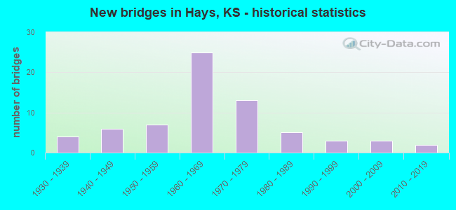
- New bridges - historical statistics
- 41930-1939
- 61940-1949
- 71950-1959
- 251960-1969
- 131970-1979
- 51980-1989
- 31990-1999
- 32000-2009
- 22010-2019
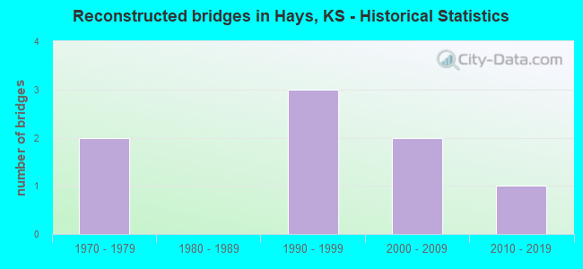
- Reconstructed bridges - Historical Statistics
- 21970-1979
- 01980-1989
- 31990-1999
- 22000-2009
- 12010-2019
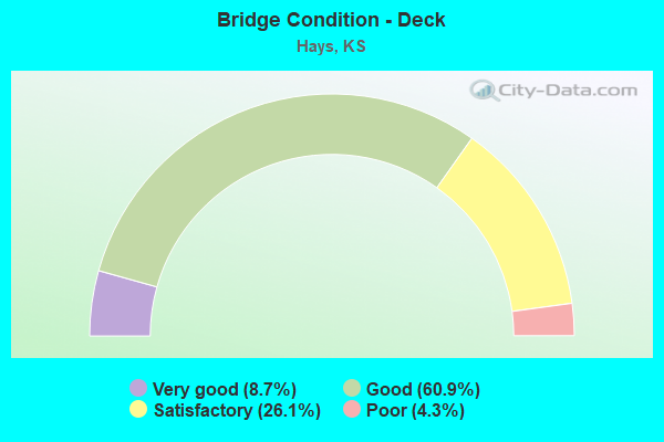
- Bridge Condition - Deck
- 8.7%Very good
- 60.9%Good
- 26.1%Satisfactory
- 4.3%Poor
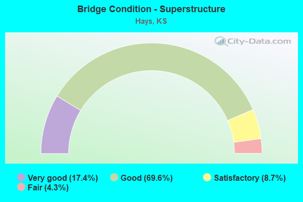
- Bridge Condition - Superstructure
- 17.4%Very good
- 69.6%Good
- 8.7%Satisfactory
- 4.3%Fair
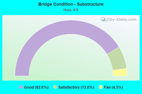
- Bridge Condition - Substructure
- 82.6%Good
- 13.0%Satisfactory
- 4.3%Fair
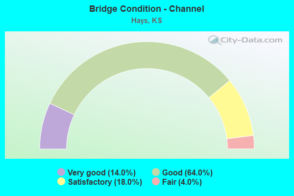
- Bridge Condition - Channel
- 14.0%Very good
- 64.0%Good
- 18.0%Satisfactory
- 4.0%Fair
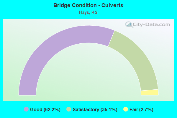
- Bridge Condition - Culverts
- 62.2%Good
- 35.1%Satisfactory
- 2.7%Fair
Find on map >> Show street view
Structure Number: 999907000260181, Location: 9.44 MI E JT K247 (Lat: 38.921667, Lng: -99.391111), Route carried "on" structure: ServiceCounty highway 325, Year Built: 1965, Status: Open, Structure Length: 7.33m (24.05ft), Average Daily Traffic: 42 (year 2020), Average Future Daily Traffic: 9,596 (year 2041), Design Load: H 15, Features Intersected: I70 HWY, NL-SL, Facility Carried by Structure: LOCAL ROAD
Minimum Vertical Clearance: 30.47m (99.97ft), Kilometerpoint: 15.282, Lanes on structure: 2, Lanes under structure: 4, Owner: State Highway Agency, Approaching Roadway Width: 7.3m (24.0ft), Material/Design: Concrete continuous, Design/Construction: Box Beam or Girders - Multiple, Number Of Spans In Main Unit: 4, Length of Maximum Span: 20.7m (67.9ft), Curb-To-Curb Width: 7.3m (24.0ft), Out-to-Out Width: 9.0m (29.5ft)
Condition: Deck: Good, Superstructure: Good, Substructure: Good, Operating Rating: 65.8 metric tons, Method Used To Determine Operating Rating: Load Factor (LF), Inventory Rating: 39.4 metric tons, Method Used To Determine Inventory Rating: Load Factor (LF), Structural Evaluation: Better than present minimum criteria, Deck Geometry: Equal to present minimum criteria, Underclear: Somewhat better than minimum adequacy, Approach Roadway Alignment: Somewhat better than minimum adequacy, Length Of Structure Improvement: 24.05m (78.90ft), Designated Inspection Frequency: Every 24 months, Inspection Date: April 2021, Deck Structure Type: Concrete Cast-file-Place, Wearing Surface/Protective System: Wearing Surface: Monolithic Concrete
Find on map >> Show street view
Structure Number: 999907000260201, Location: 1.10 MI E JT U183 ALT (Lat: 38.905556, Lng: -99.335833), Route carried "on" structure: County highway 1701, Year Built: 1964, Status: Open, Structure Length: 8.18m (26.84ft), Average Daily Traffic: 3,575 (year 2020), Average Future Daily Traffic: 5,312 (year 2041), Design Load: H 20, Features Intersected: I70 HWY, NL-SL, Facility Carried by Structure: LOCAL ROAD
Minimum Vertical Clearance: 30.47m (99.97ft), Kilometerpoint: 4.741, Lanes on structure: 2, Lanes under structure: 4, Owner: State Highway Agency, Approaching Roadway Width: 7.3m (24.0ft), Material/Design: Concrete continuous, Design/Construction: Box Beam or Girders - Multiple, Number Of Spans In Main Unit: 4, Length of Maximum Span: 23.2m (76.1ft), Curb-To-Curb Width: 8.5m (27.9ft), Out-to-Out Width: 10.2m (33.5ft)
Condition: Deck: Satisfactory, Superstructure: Good, Substructure: Good, Operating Rating: 69.9 metric tons, Method Used To Determine Operating Rating: Load Factor (LF), Inventory Rating: 41.9 metric tons, Method Used To Determine Inventory Rating: Load Factor (LF), Structural Evaluation: Better than present minimum criteria, Deck Geometry: Meets minimum limits, Underclear: Somewhat better than minimum adequacy, Approach Roadway Alignment: Meets minimum limits, Length Of Structure Improvement: 26.85m (88.09ft), Designated Inspection Frequency: Every 24 months, Inspection Date: April 2021, Deck Structure Type: Concrete Cast-file-Place, Wearing Surface/Protective System: Wearing Surface: Monolithic Concrete
Find on map >> Show street view
Structure Number: 999907000260211, Location: JCT U183/I70, WB (Lat: 38.898333, Lng: -99.317778), Route carried "on" structure: Interstate 70, Year Built: 1964, Year Reconstructed: 2019, Status: Open, Structure Length: 6.06m (19.88ft), Average Daily Traffic: 9,112 (year 2020), Truck Traffic: 24%, Average Future Daily Traffic: 12,765 (year 2041), Design Load: HS 20+Mod, Features Intersected: US183 HWY
Minimum Vertical Clearance: 30.47m (99.97ft), Kilometerpoint: 25.101, Lanes on structure: 2, Lanes under structure: 6, Base Highway Network: Yes, Owner: State Highway Agency, Approaching Roadway Width: 12.2m (40.0ft), Skew: 3 degrees, Material/Design: Concrete continuous, Design/Construction: Slab, Number Of Spans In Main Unit: 4, Length of Maximum Span: 17.1m (56.1ft), Curb-To-Curb Width: 12.2m (40.0ft), Out-to-Out Width: 12.8m (42.0ft)
Condition: Deck: Good, Superstructure: Good, Substructure: Good, Operating Rating: 62.6 metric tons, Method Used To Determine Operating Rating: Load Factor (LF), Inventory Rating: 37.2 metric tons, Method Used To Determine Inventory Rating: Load Factor (LF), Structural Evaluation: Better than present minimum criteria, Deck Geometry: Better than present minimum criteria, Underclear: Equal to present minimum criteria, Approach Roadway Alignment: Equal to present desirable criteria, Length Of Structure Improvement: 19.89m (65.26ft), Designated Inspection Frequency: Every 24 months, Inspection Date: April 2021, Deck Structure Type: Concrete Cast-file-Place, Wearing Surface/Protective System: Wearing Surface: Low Slump Concrete
Find on map >> Show street view
Structure Number: 999907000260221, Location: JCT U183/I70, EB (Lat: 38.898056, Lng: -99.317778), Route carried "on" structure: Interstate 70, Year Built: 1964, Status: Open, Structure Length: 6.06m (19.88ft), Average Daily Traffic: 9,112 (year 2020), Truck Traffic: 24%, Average Future Daily Traffic: 12,765 (year 2041), Design Load: HS 20+Mod, Features Intersected: US183 HWY
Minimum Vertical Clearance: 30.47m (99.97ft), Kilometerpoint: 25.104, Lanes on structure: 2, Lanes under structure: 4, Base Highway Network: Yes, Owner: State Highway Agency, Approaching Roadway Width: 12.2m (40.0ft), Skew: 3 degrees, Material/Design: Concrete continuous, Design/Construction: Slab, Number Of Spans In Main Unit: 4, Length of Maximum Span: 17.1m (56.1ft), Curb-To-Curb Width: 12.2m (40.0ft), Out-to-Out Width: 12.8m (42.0ft)
Condition: Deck: Good, Superstructure: Good, Substructure: Good, Operating Rating: 62.6 metric tons, Method Used To Determine Operating Rating: Load Factor (LF), Inventory Rating: 37.2 metric tons, Method Used To Determine Inventory Rating: Load Factor (LF), Structural Evaluation: Better than present minimum criteria, Deck Geometry: Better than present minimum criteria, Underclear: Equal to present minimum criteria, Approach Roadway Alignment: Equal to present desirable criteria, Length Of Structure Improvement: 19.89m (65.26ft), Designated Inspection Frequency: Every 24 months, Inspection Date: April 2021, Deck Structure Type: Concrete Cast-file-Place, Wearing Surface/Protective System: Wearing Surface: Low Slump Concrete
Find on map >> Show street view
Structure Number: 999907000260231, Location: 1.74 MI E JT U183 (Lat: 38.885833, Lng: -99.289722), Route carried "on" structure: County highway 1714, Year Built: 1964, Status: Open, Structure Length: 10.74m (35.24ft), Average Daily Traffic: 1,980 (year 2020), Average Future Daily Traffic: 2,942 (year 2041), Design Load: H 20, Features Intersected: I70 HWY, NL-SL, Facility Carried by Structure: E 27TH ST
Minimum Vertical Clearance: 30.47m (99.97ft), Kilometerpoint: 5.673, Lanes on structure: 2, Lanes under structure: 4, Owner: State Highway Agency, Approaching Roadway Width: 11.0m (36.1ft), Material/Design: Concrete continuous, Design/Construction: Box Beam or Girders - Multiple, Number Of Spans In Main Unit: 4, Length of Maximum Span: 30.5m (100.1ft), Curb-To-Curb Width: 8.5m (27.9ft), Out-to-Out Width: 10.2m (33.5ft)
Condition: Deck: Good, Superstructure: Good, Substructure: Good, Operating Rating: 64.6 metric tons, Method Used To Determine Operating Rating: Load Factor (LF), Inventory Rating: 38.6 metric tons, Method Used To Determine Inventory Rating: Load Factor (LF), Structural Evaluation: Better than present minimum criteria, Deck Geometry: Somewhat better than minimum adequacy, Underclear: Somewhat better than minimum adequacy, Approach Roadway Alignment: Meets minimum limits, Length Of Structure Improvement: 35.25m (115.65ft), Designated Inspection Frequency: Every 24 months, Inspection Date: April 2021, Deck Structure Type: Concrete Cast-file-Place, Wearing Surface/Protective System: Wearing Surface: Monolithic Concrete
Find on map >> Show street view
Structure Number: 999907000260241, Location: 4.35 MI E JT U183 (Lat: 38.878333, Lng: -99.243611), Route carried "on" structure: County highway 1877, Year Built: 1965, Status: Open, Structure Length: 7.33m (24.05ft), Average Daily Traffic: 780 (year 2020), Average Future Daily Traffic: 10,297 (year 2041), Design Load: H 20, Features Intersected: I70 HWY, NL-SL, Facility Carried by Structure: TOULON AVE
Minimum Vertical Clearance: 30.47m (99.97ft), Kilometerpoint: 2.964, Lanes on structure: 2, Lanes under structure: 4, Owner: State Highway Agency, Approaching Roadway Width: 11.0m (36.1ft), Material/Design: Concrete continuous, Design/Construction: Box Beam or Girders - Multiple, Number Of Spans In Main Unit: 4, Length of Maximum Span: 20.7m (67.9ft), Curb-To-Curb Width: 8.5m (27.9ft), Out-to-Out Width: 8.9m (29.2ft)
Condition: Deck: Satisfactory, Superstructure: Good, Substructure: Good, Operating Rating: 69.9 metric tons, Method Used To Determine Operating Rating: Load Factor (LF), Inventory Rating: 41.7 metric tons, Method Used To Determine Inventory Rating: Load Factor (LF), Structural Evaluation: Better than present minimum criteria, Deck Geometry: Somewhat better than minimum adequacy, Underclear: Somewhat better than minimum adequacy, Approach Roadway Alignment: Meets minimum limits, Length Of Structure Improvement: 24.05m (78.90ft), Designated Inspection Frequency: Every 24 months, Inspection Date: April 2021, Deck Structure Type: Concrete Cast-file-Place, Wearing Surface/Protective System: Wearing Surface: Low Slump Concrete
Find on map >> Show street view
Structure Number: 999907000260251, Location: 4.55 MI E JT U183 (Lat: 38.878333, Lng: -99.240000), Route carried "on" structure: Interstate 70, Year Built: 1965, Status: Open, Structure Length: 1.14m (3.74ft), Average Daily Traffic: 8,020 (year 2020), Truck Traffic: 23%, Average Future Daily Traffic: 11,236 (year 2041), Design Load: HS 20+Mod, Features Intersected: BIG CREEK DRAINAGE
Minimum Vertical Clearance: 30.47m (99.97ft), Kilometerpoint: 32.422, Lanes on structure: 5, Base Highway Network: Yes, Owner: State Highway Agency, Approaching Roadway Width: 24.4m (80.1ft), Skew: 20 degrees, Material/Design: Concrete, Design/Construction: Culvert, Number Of Spans In Main Unit: 3, Length of Maximum Span: 3.7m (12.1ft), Curb-To-Curb Width: 29.0m (95.1ft), Out-to-Out Width: 45.6m (149.6ft)
Condition: Channel: Good, Culverts: Satisfactory, Operating Rating: 39.9 metric tons, Method Used To Determine Operating Rating: Load Factor (LF), Inventory Rating: 23.6 metric tons, Method Used To Determine Inventory Rating: Load Factor (LF), Structural Evaluation: Somewhat better than minimum adequacy, Deck Geometry: Superior to present desirable criteria, Waterway Adequacy: Better than present minimum criteria, Approach Roadway Alignment: Equal to present desirable criteria, Length Of Structure Improvement: 3.75m (12.30ft), Designated Inspection Frequency: Every 24 months, Inspection Date: April 2021, Deck Structure Type: Concrete Cast-file-Place, Wearing Surface/Protective System: Wearing Surface: Bituminous
Find on map >> Show street view
Structure Number: 999907000260581, Location: 2.31 MI E JCT US-183 (Lat: 38.881667, Lng: -99.280556), Route carried "on" structure: County highway 1733, Year Built: 1994, Status: Open, Structure Length: 9.62m (31.56ft), Average Daily Traffic: 2,775 (year 2020), Average Future Daily Traffic: 3,128 (year 2041), Design Load: HS 25 or greater, Features Intersected: I-70 HWY NL-SL, Facility Carried by Structure: COMERCE PWY RD
Minimum Vertical Clearance: 30.47m (99.97ft), Kilometerpoint: 6.033, Lanes on structure: 2, Lanes under structure: 4, Owner: State Highway Agency, Approaching Roadway Width: 13.4m (44.0ft), Skew: 2 degrees, Material/Design: Prestressed concrete continuous, Design/Construction: Stringer/Multi-beam, Number Of Spans In Main Unit: 4, Length of Maximum Span: 31.7m (104.0ft), Curb-To-Curb Width: 12.2m (40.0ft), Out-to-Out Width: 13.0m (42.7ft)
Condition: Deck: Good, Superstructure: Very good, Substructure: Good, Operating Rating: 74.6 metric tons, Method Used To Determine Operating Rating: Load Factor (LF), Inventory Rating: 40.9 metric tons, Method Used To Determine Inventory Rating: Load Factor (LF), Structural Evaluation: Better than present minimum criteria, Deck Geometry: Equal to present minimum criteria, Underclear: Somewhat better than minimum adequacy, Approach Roadway Alignment: Meets minimum limits, Length Of Structure Improvement: 31.55m (103.51ft), Designated Inspection Frequency: Every 24 months, Inspection Date: April 2021, Wearing Surface/Protective System: Wearing Surface: Low Slump Concrete, Deck Protection: Epoxy Coated Reinforcing
Find on map >> Show street view
Structure Number: 999918100530291, Location: 4.03 MI E RUSSELL COLN (Lat: 38.957500, Lng: -98.413333), Route carried "on" structure: State highway 181, Year Built: 1970, Status: Open, Structure Length: 3.12m (10.24ft), Average Daily Traffic: 150 (year 2020), Truck Traffic: 20%, Average Future Daily Traffic: 179 (year 2041), Design Load: H 15, Features Intersected: WEST TWIN CREEK
Minimum Vertical Clearance: 30.47m (99.97ft), Kilometerpoint: 6.383, Lanes on structure: 2, Owner: State Highway Agency, Approaching Roadway Width: 7.3m (24.0ft), Material/Design: Concrete continuous, Design/Construction: Slab, Number Of Spans In Main Unit: 3, Length of Maximum Span: 12.2m (40.0ft), Curb-To-Curb Width: 8.5m (27.9ft), Out-to-Out Width: 9.1m (29.9ft)
Condition: Deck: Good, Superstructure: Good, Substructure: Good, Channel: Very good, Operating Rating: 39.9 metric tons, Method Used To Determine Operating Rating: Load Factor (LF), Inventory Rating: 23.6 metric tons, Method Used To Determine Inventory Rating: Load Factor (LF), Structural Evaluation: Equal to present minimum criteria, Deck Geometry: Equal to present minimum criteria, Waterway Adequacy: Better than present minimum criteria, Approach Roadway Alignment: Better than present minimum criteria, Length Of Structure Improvement: 10.25m (33.63ft), Designated Inspection Frequency: Every 24 months, Inspection Date: April 2020, Deck Structure Type: Concrete Cast-file-Place, Wearing Surface/Protective System: Wearing Surface: Low Slump Concrete
Find on map >> Show street view
Structure Number: 999918300260451, Location: 8.57 MI N RUSH COLN (Lat: 38.820833, Lng: -99.318611), Route carried "on" structure: US 183, Year Built: 1970, Status: Open, Structure Length: 0.76m (2.49ft), Average Daily Traffic: 4,505 (year 2020), Truck Traffic: 15%, Average Future Daily Traffic: 5,949 (year 2041), Design Load: H 20, Features Intersected: BIG CREEK DRAINAGE
Minimum Vertical Clearance: 30.47m (99.97ft), Kilometerpoint: 13.797, Lanes on structure: 2, Base Highway Network: Yes, Owner: State Highway Agency, Approaching Roadway Width: 13.4m (44.0ft), Material/Design: Concrete, Design/Construction: Culvert, Number Of Spans In Main Unit: 2, Length of Maximum Span: 3.7m (12.1ft), Curb-To-Curb Width: 13.4m (44.0ft), Out-to-Out Width: 27.4m (89.9ft)
Condition: Channel: Very good, Culverts: Good, Operating Rating: 58.1 metric tons, Method Used To Determine Operating Rating: Load Factor (LF), Inventory Rating: 35.4 metric tons, Method Used To Determine Inventory Rating: Load Factor (LF), Structural Evaluation: Better than present minimum criteria, Deck Geometry: Better than present minimum criteria, Waterway Adequacy: Equal to present desirable criteria, Approach Roadway Alignment: Equal to present desirable criteria, Length Of Structure Improvement: 2.48m (8.14ft), Designated Inspection Frequency: Every 24 months, Inspection Date: April 2021, Deck Structure Type: Concrete Cast-file-Place, Wearing Surface/Protective System: Wearing Surface: Bituminous
Find on map >> Show street view
Structure Number: 999918300260461, Location: 9.53 MI N RUSH COLN (Lat: 38.834722, Lng: -99.318611), Route carried "on" structure: US 183, Year Built: 1970, Status: Open, Structure Length: 0.95m (3.12ft), Average Daily Traffic: 4,505 (year 2020), Truck Traffic: 15%, Average Future Daily Traffic: 5,949 (year 2041), Design Load: H 20, Features Intersected: BIG CREEK DRAINAGE
Minimum Vertical Clearance: 30.47m (99.97ft), Kilometerpoint: 15.332, Lanes on structure: 2, Base Highway Network: Yes, Owner: State Highway Agency, Approaching Roadway Width: 13.4m (44.0ft), Material/Design: Concrete, Design/Construction: Culvert, Number Of Spans In Main Unit: 3, Length of Maximum Span: 3.0m (9.8ft), Curb-To-Curb Width: 13.4m (44.0ft), Out-to-Out Width: 14.0m (45.9ft)
Condition: Channel: Very good, Culverts: Good, Operating Rating: 29.7 metric tons, Method Used To Determine Operating Rating: Load Factor (LF), Inventory Rating: 17.8 metric tons, Method Used To Determine Inventory Rating: Load Factor (LF), Structural Evaluation: Meets minimum limits, Deck Geometry: Better than present minimum criteria, Waterway Adequacy: Equal to present desirable criteria, Approach Roadway Alignment: Equal to present desirable criteria, Length Of Structure Improvement: 3.13m (10.27ft), Designated Inspection Frequency: Every 24 months, Inspection Date: April 2021, Deck Structure Type: Concrete Cast-file-Place, Wearing Surface/Protective System: Wearing Surface: Bituminous
Find on map >> Show street view
Structure Number: 999918300260471, Location: 10.50 MI N RUSH COLN (Lat: 38.848611, Lng: -99.318333), Route carried "on" structure: US 183, Year Built: 1970, Status: Open, Structure Length: 0.85m (2.79ft), Average Daily Traffic: 5,720 (year 2020), Truck Traffic: 10%, Average Future Daily Traffic: 7,554 (year 2041), Design Load: HS 20, Features Intersected: LOCAL ROAD
Minimum Vertical Clearance: 30.47m (99.97ft), Kilometerpoint: 16.890, Lanes on structure: 2, Lanes under structure: 2, Base Highway Network: Yes, Owner: State Highway Agency, Approaching Roadway Width: 13.4m (44.0ft), Material/Design: Concrete, Design/Construction: Culvert, Number Of Spans In Main Unit: 1, Length of Maximum Span: 8.5m (27.9ft), Curb-To-Curb Width: 13.4m (44.0ft), Out-to-Out Width: 14.0m (45.9ft)
Condition: Culverts: Good, Operating Rating: 60.8 metric tons, Method Used To Determine Operating Rating: Load Factor (LF), Inventory Rating: 36.3 metric tons, Method Used To Determine Inventory Rating: Load Factor (LF), Structural Evaluation: Better than present minimum criteria, Deck Geometry: Equal to present minimum criteria, Underclear: High priority of corrective action, Approach Roadway Alignment: Equal to present desirable criteria, Length Of Structure Improvement: 2.80m (9.19ft), Designated Inspection Frequency: Every 24 months, Inspection Date: April 2021, Deck Structure Type: Concrete Cast-file-Place, Wearing Surface/Protective System: Wearing Surface: Bituminous
Find on map >> Show street view
Structure Number: 999918300260481, Location: 10.76 MI N RUSH COLN (Lat: 38.852500, Lng: -99.318056), Route carried "on" structure: US 183, Year Built: 1970, Status: Open, Structure Length: 9.53m (31.27ft), Average Daily Traffic: 5,720 (year 2020), Truck Traffic: 10%, Average Future Daily Traffic: 7,554 (year 2041), Design Load: HS 20, Features Intersected: BIG CREEK
Minimum Vertical Clearance: 30.47m (99.97ft), Kilometerpoint: 17.323, Lanes on structure: 2, Base Highway Network: Yes, Owner: State Highway Agency, Approaching Roadway Width: 13.4m (44.0ft), Material/Design: Concrete continuous, Design/Construction: Tee Beam, Number Of Spans In Main Unit: 5, Length of Maximum Span: 21.3m (69.9ft), Curb-To-Curb Width: 13.4m (44.0ft), Out-to-Out Width: 14.0m (45.9ft)
Condition: Deck: Good, Superstructure: Good, Substructure: Good, Channel: Good, Operating Rating: 53.1 metric tons, Method Used To Determine Operating Rating: Load Factor (LF), Inventory Rating: 31.8 metric tons, Method Used To Determine Inventory Rating: Load Factor (LF), Structural Evaluation: Better than present minimum criteria, Deck Geometry: Equal to present minimum criteria, Waterway Adequacy: Equal to present desirable criteria, Approach Roadway Alignment: Equal to present desirable criteria, Length Of Structure Improvement: 31.25m (102.53ft), Designated Inspection Frequency: Every 24 months, Inspection Date: April 2021, Deck Structure Type: Concrete Cast-file-Place, Wearing Surface/Protective System: Wearing Surface: Low Slump Concrete
Find on map >> Show street view
Structure Number: 999918300260491, Location: 04.42 MI N JT I70 (Lat: 38.962222, Lng: -99.316667), Route carried "on" structure: US 183, Year Built: 1962, Year Reconstructed: 2008, Status: Open, Structure Length: 0.88m (2.89ft), Average Daily Traffic: 3,650 (year 2020), Truck Traffic: 20%, Average Future Daily Traffic: 5,215 (year 2041), Design Load: H 20, Features Intersected: N FK BIG CREEK
Minimum Vertical Clearance: 30.47m (99.97ft), Kilometerpoint: 29.528, Lanes on structure: 2, Base Highway Network: Yes, Owner: State Highway Agency, Approaching Roadway Width: 13.4m (44.0ft), Material/Design: Concrete, Design/Construction: Culvert, Number Of Spans In Main Unit: 2, Length of Maximum Span: 4.3m (14.1ft), Curb-To-Curb Width: 13.4m (44.0ft), Out-to-Out Width: 23.6m (77.4ft)
Condition: Channel: Very good, Culverts: Good, Operating Rating: 48.1 metric tons, Method Used To Determine Operating Rating: Load Factor (LF), Inventory Rating: 28.1 metric tons, Method Used To Determine Inventory Rating: Load Factor (LF), Structural Evaluation: Better than present minimum criteria, Deck Geometry: Better than present minimum criteria, Waterway Adequacy: Equal to present desirable criteria, Approach Roadway Alignment: Equal to present desirable criteria, Length Of Structure Improvement: 2.88m (9.45ft), Designated Inspection Frequency: Every 24 months, Inspection Date: April 2021, Deck Structure Type: Concrete Cast-file-Place, Wearing Surface/Protective System: Wearing Surface: Bituminous
Find on map >> Show street view
Structure Number: 9999183Y0260191, Location: JT U183Y/I70 (Lat: 38.912222, Lng: -99.354444), Route carried "on" structure: Bypass US 183, Year Built: 1964, Status: Open, Structure Length: 8.18m (26.84ft), Average Daily Traffic: 4,665 (year 2020), Truck Traffic: 12%, Average Future Daily Traffic: 6,283 (year 2041), Design Load: H 20, Features Intersected: I70 HWY, NL-SL
Minimum Vertical Clearance: 30.47m (99.97ft), Kilometerpoint: 0.084, Lanes on structure: 2, Lanes under structure: 4, Base Highway Network: Yes, Owner: State Highway Agency, Approaching Roadway Width: 9.1m (29.9ft), Material/Design: Concrete continuous, Design/Construction: Box Beam or Girders - Multiple, Number Of Spans In Main Unit: 4, Length of Maximum Span: 23.2m (76.1ft), Curb-To-Curb Width: 9.1m (29.9ft), Out-to-Out Width: 9.9m (32.5ft)
Condition: Deck: Satisfactory, Superstructure: Good, Substructure: Good, Operating Rating: 68.3 metric tons, Method Used To Determine Operating Rating: Load Factor (LF), Inventory Rating: 40.9 metric tons, Method Used To Determine Inventory Rating: Load Factor (LF), Structural Evaluation: Better than present minimum criteria, Deck Geometry: Meets minimum limits, Underclear: Somewhat better than minimum adequacy, Approach Roadway Alignment: Meets minimum limits, Length Of Structure Improvement: 26.85m (88.09ft), Designated Inspection Frequency: Every 24 months, Inspection Date: April 2021, Deck Structure Type: Concrete Cast-file-Place, Wearing Surface/Protective System: Wearing Surface: Low Slump Concrete
Find on map >> Show street view
Structure Number: 9999183Y0260531, Location: 0.64 MI W JCT U183/U183Y (Lat: 38.862500, Lng: -99.329722), Route carried "on" structure: Bypass US 183, Year Built: 1953, Year Reconstructed: 1997, Status: Open, Structure Length: 7.35m (24.11ft), Average Daily Traffic: 5,380 (year 2020), Truck Traffic: 10%, Average Future Daily Traffic: 6,565 (year 2041), Design Load: H 20, Features Intersected: BIG CREEK
Minimum Vertical Clearance: 30.47m (99.97ft), Kilometerpoint: 1.025, Lanes on structure: 2, Base Highway Network: Yes, Owner: State Highway Agency, Approaching Roadway Width: 13.4m (44.0ft), Material/Design: Steel continuous, Design/Construction: Stringer/Multi-beam, Number Of Spans In Main Unit: 3, Length of Maximum Span: 28.0m (91.9ft), Curb-To-Curb Width: 13.4m (44.0ft), Out-to-Out Width: 14.0m (45.9ft)
Condition: Deck: Good, Superstructure: Very good, Substructure: Good, Channel: Good, Operating Rating: 48.1 metric tons, Method Used To Determine Operating Rating: Load Factor (LF), Inventory Rating: 29.0 metric tons, Method Used To Determine Inventory Rating: Load Factor (LF), Structural Evaluation: Better than present minimum criteria, Deck Geometry: Equal to present minimum criteria, Waterway Adequacy: Better than present minimum criteria, Approach Roadway Alignment: Equal to present desirable criteria, Length Of Structure Improvement: 24.10m (79.07ft), Designated Inspection Frequency: Every 24 months, Inspection Date: April 2021, Deck Structure Type: Concrete Cast-file-Place, Wearing Surface/Protective System: Wearing Surface: Low Slump Concrete
Find on map >> Show street view
Structure Number: 9999183Y0260541, Location: 2.60 MI NW JCT U183/U183Y (Lat: 38.878889, Lng: -99.353889), Route carried "on" structure: Bypass US 183, Year Built: 1966, Year Reconstructed: 1997, Status: Open, Structure Length: 1.28m (4.20ft), Average Daily Traffic: 4,840 (year 2020), Truck Traffic: 11%, Average Future Daily Traffic: 6,519 (year 2041), Design Load: H 20, Features Intersected: BIG CREEK DRAINAGE
Minimum Vertical Clearance: 30.47m (99.97ft), Kilometerpoint: 3.465, Lanes on structure: 4, Base Highway Network: Yes, Owner: State Highway Agency, Approaching Roadway Width: 13.4m (44.0ft), Skew: 20 degrees, Material/Design: Concrete, Design/Construction: Culvert, Number Of Spans In Main Unit: 5, Length of Maximum Span: 2.4m (7.9ft), Curb-To-Curb Width: 12.8m (42.0ft), Out-to-Out Width: 52.4m (171.9ft)
Condition: Channel: Very good, Culverts: Good, Operating Rating: 89.8 metric tons, Method Used To Determine Operating Rating: Load Factor (LF), Inventory Rating: 89.8 metric tons, Method Used To Determine Inventory Rating: Load Factor (LF), Structural Evaluation: Better than present minimum criteria, Deck Geometry: High priority of replacement, Waterway Adequacy: Equal to present desirable criteria, Approach Roadway Alignment: Meets minimum limits, Length Of Structure Improvement: 4.20m (13.78ft), Designated Inspection Frequency: Every 24 months, Inspection Date: April 2021, Deck Structure Type: Concrete Cast-file-Place, Wearing Surface/Protective System: Wearing Surface: Bituminous
Find on map >> Show street view
Structure Number: 9999183Y0260551, Location: 2.84 MI NW JCT U183/U183Y (Lat: 38.882500, Lng: -99.354444), Route carried "on" structure: Bypass US 183, Year Built: 1966, Year Reconstructed: 1997, Status: Open, Structure Length: 16.62m (54.53ft), Average Daily Traffic: 4,840 (year 2020), Truck Traffic: 11%, Average Future Daily Traffic: 6,519 (year 2041), Design Load: H 20, Features Intersected: RS1977, UP RR, OLD US40
Minimum Vertical Clearance: 30.47m (99.97ft), Kilometerpoint: 4.561, Lanes on structure: 2, Lanes under structure: 4, Base Highway Network: Yes, Owner: State Highway Agency, Approaching Roadway Width: 13.4m (44.0ft), Skew: 3 degrees, Material/Design: Steel continuous, Design/Construction: Stringer/Multi-beam, Number Of Spans In Main Unit: 9, Length of Maximum Span: 19.2m (63.0ft), Curb-To-Curb Width: 13.4m (44.0ft), Out-to-Out Width: 14.0m (45.9ft)
Condition: Deck: Good, Superstructure: Good, Substructure: Good, Operating Rating: 73.5 metric tons, Method Used To Determine Operating Rating: Load Factor (LF), Inventory Rating: 43.5 metric tons, Method Used To Determine Inventory Rating: Load Factor (LF), Structural Evaluation: Better than present minimum criteria, Deck Geometry: Better than present minimum criteria, Underclear: Equal to present minimum criteria, Approach Roadway Alignment: Meets minimum limits, Length Of Structure Improvement: 54.54m (178.94ft), Designated Inspection Frequency: Every 24 months, Inspection Date: April 2021, Wearing Surface/Protective System: Wearing Surface: Low Slump Concrete, Deck Protection: Epoxy Coated Reinforcing
Find on map >> Show street view
Structure Number: 9999183Y0260561, Location: 0.14 MI NW JCT OLD 40 HWY (Lat: 38.885000, Lng: -99.354444), Route carried "on" structure: Bypass US 183, Year Built: 1966, Status: Open, Structure Length: 8.85m (29.04ft), Average Daily Traffic: 4,665 (year 2020), Truck Traffic: 12%, Average Future Daily Traffic: 6,283 (year 2041), Design Load: HS 20, Features Intersected: BIG CREEK
Minimum Vertical Clearance: 30.47m (99.97ft), Kilometerpoint: 4.846, Lanes on structure: 4, Base Highway Network: Yes, Owner: State Highway Agency, Approaching Roadway Width: 13.4m (44.0ft), Material/Design: Concrete continuous, Design/Construction: Tee Beam, Number Of Spans In Main Unit: 4, Length of Maximum Span: 25.6m (84.0ft), Curb-To-Curb Width: 18.3m (60.0ft), Out-to-Out Width: 18.9m (62.0ft)
Condition: Deck: Good, Superstructure: Good, Substructure: Satisfactory, Channel: Satisfactory, Operating Rating: 64.5 metric tons, Method Used To Determine Operating Rating: Load Factor (LF), Inventory Rating: 39.0 metric tons, Method Used To Determine Inventory Rating: Load Factor (LF), Structural Evaluation: Equal to present minimum criteria, Deck Geometry: Somewhat better than minimum adequacy, Waterway Adequacy: Somewhat better than minimum adequacy, Approach Roadway Alignment: Meets minimum limits, Length Of Structure Improvement: 29.05m (95.31ft), Designated Inspection Frequency: Every 24 months, Inspection Date: April 2021, Deck Structure Type: Concrete Cast-file-Place, Wearing Surface/Protective System: Wearing Surface: Low Slump Concrete
Find on map >> Show street view
Structure Number: 999907000260181, Location: 9.44 MI E JT K247 (Lat: 38.921667, Lng: -99.391111), Route carried "under" structure: Interstate 70, Year Built: 1965, Structure Length: 0. m, Average Daily Traffic: 7,475 (year 2020), Truck Traffic: 28%, Features Intersected: I70 HWY, NL-SL, Facility Carried by Structure: LOCAL ROAD
Minimum Vertical Clearance: 4.93m (16.17ft), Kilometerpoint: 18.173, Lanes on structure: 2, Lanes under structure: 4, Material/Design: Concrete continuous, Design/Construction: Box Beam or Girders - Multiple, Length of Maximum Span: 20.7m (67.9ft)
Find on map >> Show street view
Structure Number: 999907000260201, Location: 1.10 MI E JT U183 ALT (Lat: 38.905556, Lng: -99.335833), Route carried "under" structure: Interstate 70, Year Built: 1964, Structure Length: 0. m, Average Daily Traffic: 9,112 (year 2020), Truck Traffic: 24%, Features Intersected: I70 HWY, NL-SL, Facility Carried by Structure: LOCAL ROAD
Minimum Vertical Clearance: 4.93m (16.17ft), Kilometerpoint: 23.327, Lanes on structure: 2, Lanes under structure: 4, Material/Design: Concrete continuous, Design/Construction: Box Beam or Girders - Multiple, Length of Maximum Span: 23.2m (76.1ft)
Find on map >> Show street view
Structure Number: 999907000260211, Location: JCT U183/I70, WB (Lat: 38.898333, Lng: -99.317778), Route carried "under" structure: US 183, Year Built: 1964, Structure Length: 0. m, Average Daily Traffic: 9,405 (year 2020), Truck Traffic: 1%, Features Intersected: US183 HWY, Facility Carried by Structure: I70 HWY, WB
Minimum Vertical Clearance: 4.82m (15.81ft), Kilometerpoint: 22.431, Lanes on structure: 2, Lanes under structure: 6, Material/Design: Concrete continuous, Design/Construction: Slab, Length of Maximum Span: 17.1m (56.1ft)
Find on map >> Show street view
Structure Number: 999907000260221, Location: JCT U183/I70, EB (Lat: 38.898056, Lng: -99.317778), Route carried "under" structure: US 183, Year Built: 1964, Structure Length: 0. m, Average Daily Traffic: 9,405 (year 2020), Truck Traffic: 1%, Features Intersected: US183 HWY, Facility Carried by Structure: I70 HWY, EB
Minimum Vertical Clearance: 4.92m (16.14ft), Kilometerpoint: 22.400, Lanes on structure: 2, Lanes under structure: 4, Material/Design: Concrete continuous, Design/Construction: Slab, Length of Maximum Span: 17.1m (56.1ft)
Find on map >> Show street view
Structure Number: 999907000260231, Location: 1.74 MI E JT U183 (Lat: 38.885833, Lng: -99.289722), Route carried "under" structure: Interstate 70, Year Built: 1964, Structure Length: 0. m, Average Daily Traffic: 9,875 (year 2020), Truck Traffic: 19%, Features Intersected: I70 HWY, NL-SL, Facility Carried by Structure: E 27TH ST
Minimum Vertical Clearance: 4.81m (15.78ft), Kilometerpoint: 27.914, Lanes on structure: 2, Lanes under structure: 4, Material/Design: Concrete continuous, Design/Construction: Box Beam or Girders - Multiple, Length of Maximum Span: 30.5m (100.1ft)
Find on map >> Show street view
Structure Number: 999907000260241, Location: 4.35 MI E JT U183 (Lat: 38.878333, Lng: -99.243611), Route carried "under" structure: Interstate 70, Year Built: 1965, Structure Length: 0. m, Average Daily Traffic: 8,020 (year 2020), Truck Traffic: 23%, Features Intersected: I70 HWY, NL-SL, Facility Carried by Structure: TOULON AVE
Minimum Vertical Clearance: 4.80m (15.75ft), Kilometerpoint: 32.102, Lanes on structure: 2, Lanes under structure: 4, Material/Design: Concrete continuous, Design/Construction: Box Beam or Girders - Multiple, Length of Maximum Span: 20.7m (67.9ft)
Find on map >> Show street view
Structure Number: 999907000260581, Location: 2.31 MI E JCT US-183 (Lat: 38.881667, Lng: -99.280556), Route carried "under" structure: Interstate 70, Year Built: 1994, Structure Length: 0. m, Average Daily Traffic: 9,875 (year 2020), Truck Traffic: 19%, Features Intersected: I-70 HWY NL-SL, Facility Carried by Structure: COMERCE PWY RD
Minimum Vertical Clearance: 4.98m (16.34ft), Kilometerpoint: 28.819, Lanes on structure: 2, Lanes under structure: 4, Material/Design: Prestressed concrete continuous, Design/Construction: Stringer/Multi-beam, Length of Maximum Span: 31.7m (104.0ft)
Find on map >> Show street view
Structure Number: 9999183Y0260191, Location: JT U183Y/I70 (Lat: 38.912222, Lng: -99.354444), Route carried "under" structure: Interstate 70, Year Built: 1964, Structure Length: 0. m, Average Daily Traffic: 7,475 (year 2020), Truck Traffic: 28%, Features Intersected: I70 HWY, NL-SL, Facility Carried by Structure: US183 BYPASS
Minimum Vertical Clearance: 4.90m (16.08ft), Kilometerpoint: 21.556, Lanes on structure: 2, Lanes under structure: 4, Material/Design: Concrete continuous, Design/Construction: Box Beam or Girders - Multiple, Length of Maximum Span: 23.2m (76.1ft)